geo-cradle in support to sdgs implementation in the...
TRANSCRIPT
GEO-CRADLE in support to SDGs implementation in the areas of Adaptation to Climate Change,
Improved Food Security & Water Extremes Management, Access to Raw Materials and Access to Energy
Alexia Tsouni GEO-CRADLE Project Coordination Team
National Observatory of Athens
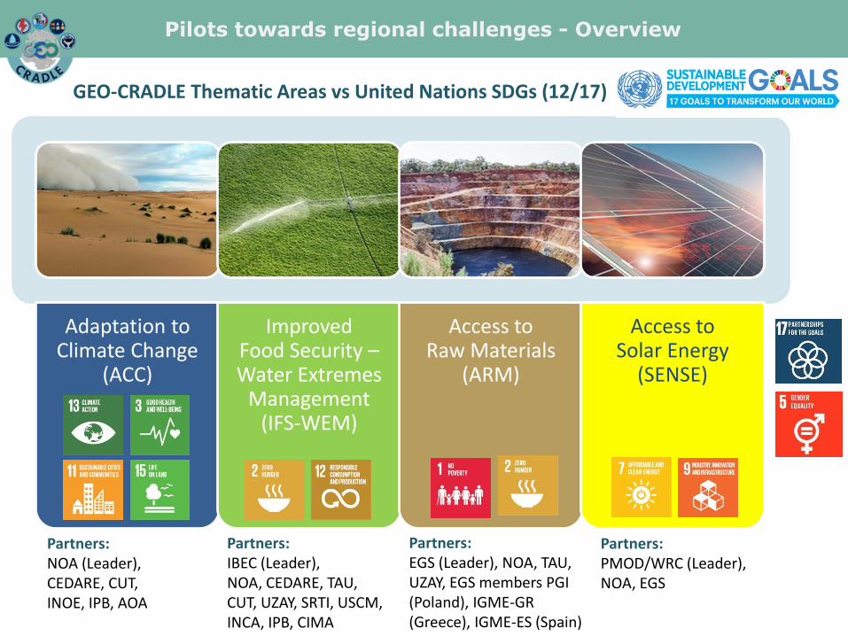
Pilots towards regional challenges - Overview
Adaptation to Climate Change
(ACC)
Improved Food Security – Water Extremes
Management (IFS-WEM)
Access to Raw Materials
(ARM)
Access to Solar Energy
(SENSE)
GEO-CRADLE Thematic Areas vs United Nations SDGs (12/17)
Partners: NOA (Leader), CEDARE, CUT, INOE, IPB, AOA
Partners: IBEC (Leader), NOA, CEDARE, TAU, CUT, UZAY, SRTI, USCM, INCA, IPB, CIMA
Partners: EGS (Leader), NOA, TAU, UZAY, EGS members PGI (Poland), IGME-GR (Greece), IGME-ES (Spain)
Partners: PMOD/WRC (Leader), NOA, EGS
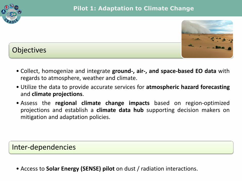
Pilot 1: Adaptation to Climate Change
Objectives
• Collect, homogenize and integrate ground-, air-, and space-based EO data with regards to atmosphere, weather and climate.
• Utilize the data to provide accurate services for atmospheric hazard forecasting and climate projections.
• Assess the regional climate change impacts based on region-optimized projections and establish a climate data hub supporting decision makers on mitigation and adaptation policies.
Inter-dependencies
• Access to Solar Energy (SENSE) pilot on dust / radiation interactions.

Overall, the analysis of the interviews regarding the end-user needs, the maturity status of the countries and partners in the RoI and the potential stakeholders’ synergies, resulted in three ACC services, namely:
i) desert dust services
ii) air quality services
iii) regional climate change projection services.
State-of-the art, progress, achievements, impact
Pilot 1: Adaptation to Climate Change
• For optimal response to the end user requirements, corresponding data have been provided to potential users in order to receive feedback for the further development of the ACC services. E.g. the “Climate Projection” web application was refined, to be more user-friendly and accurately provide past-present-future climate information using Essential Climate Variables (ECVs) and Climate Indices (CI).

i) desert dust services, and ii) air quality services
Lidar atmospheric profiles
PRE-TECT Campaign (desert dust and air quality services)
Pilot 1: Adaptation to Climate Change
* These services are provided by using ground and air measurements of dust properties in conjunction with atmospheric forecasting models over Greece & Cyprus. * An atmospheric experimental campaign dubbed PRE-TECT was conducted between 1st and 30th of April 2017, in Finokalia, in the island of Crete, Greece. A multitude of remote sensing instrumentations are operated at Finokalia station, including sunphotometers, Doppler wind lidars, microwave radiometer, magnetometers and many more.

GEOCLIMA and Climate Projection web tools
Pilot 1: Adaptation to Climate Change
iii) regional climate change projection services
* Development of a climate projection web application which plots timeseries of Essential Climate Variables (ECVs) and Climate Indices (CI), 30 climate simulations for 1950-2100, mean timeseries of historical and future representative concentration pathway scenarios, depicting various moments, etc.

• These open-access information are especially important for the following sectors:
Agriculture Droughts, intense rainfall, frost, evaporation or even
growing season periods for plants.
Tourism Favorable summer and winter
conditions for tourists by combining various Essential
Climate Variables.
Natural Hazards Extreme rainfall, intense wind
velocity and fires.
Energy Potential solar and power
production, as well as estimated energy
requirements of households.
Pilot 1: Adaptation to Climate Change

So far collaboration has been established with the following end-users:
• The Ministry of Agriculture, Rural Development and Environment of Cyprus.
• The University of Belgrade Institute of Meteorology in Serbia.
• Balloonera, a private company in Belgrade, Serbia, developing a radiosounding platform.
• The regional hydrology and water resources Sebou Basin Agency (ABHS) of Morocco.
• The Department of Infrastructure and Rural Development of the School of Rural and Surveying Engineering of the National Technical University of Athens (NTUA), Greece.
• The Centre for the Assessment of Natural Hazards and Proactive Planning (CANaH) of the National Technical University of Athens (NTUA), Greece.
• TEMES S.A., a premier destination developer & operator in the high end tourism and real estate sector in Greece.
Experimental campaigns from which data will be integrated 3
Spin-off and R&D projects built on this GEO-CRADLE pilot 2 (CLAIRE, Invictus)
Pilot 1: Adaptation to Climate Change
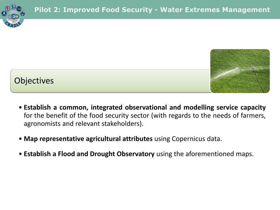
Pilot 2: Improved Food Security - Water Extremes Management
Objectives
• Establish a common, integrated observational and modelling service capacity for the benefit of the food security sector (with regards to the needs of farmers, agronomists and relevant stakeholders).
• Map representative agricultural attributes using Copernicus data.
• Establish a Flood and Drought Observatory using the aforementioned maps.

Generation of a Regional Soil Spectral Library
(IFS pilot)
Creation of the soil moisture
and clay content maps applying the models on a pixel by pixel
basis on Sentinel -2 reflectance
data
Prediction of soil moisture and clay content using spectral based models
Application of the thematic maps into the Flood
Forecast Model (WEM pilot)
Pilot 2: Improved Food Security - Water Extremes Management
Continuum hydrological model
Resampling of the models into Sentinel-2 spectral configuration

More than 2,000 soil samples collected.
Regional Soil Samples Libraries built for Greece, FYROM, Israel, Serbia, Cyprus, Turkey, Bulgaria and Albania.
2 training days and 2 webinars hosted.
Initial maps for the Drin river basin in Albania.
Base of the myDEWETRA platform completed.
The publicly available soil spectral data of the RoI will increase by 400% in the end of the project.
State-of-the art, progress, achievements, impact
Pilot 2: Improved Food Security - Water Extremes Management
soil clay content map
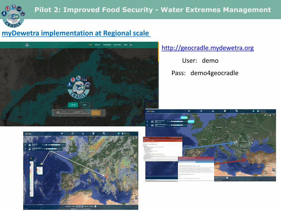
myDewetra implementation at Regional scale
User: demo
Pass: demo4geocradle
http://geocradle.mydewetra.org
Pilot 2: Improved Food Security - Water Extremes Management
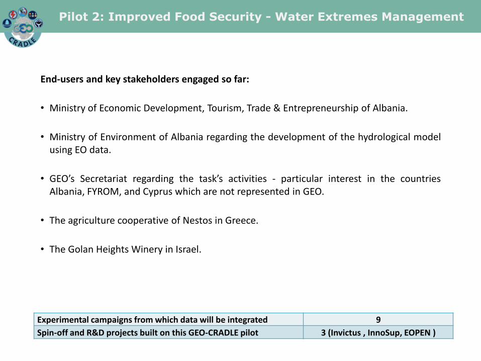
End-users and key stakeholders engaged so far:
• Ministry of Economic Development, Tourism, Trade & Entrepreneurship of Albania.
• Ministry of Environment of Albania regarding the development of the hydrological model using EO data.
• GEO’s Secretariat regarding the task’s activities - particular interest in the countries Albania, FYROM, and Cyprus which are not represented in GEO.
• The agriculture cooperative of Nestos in Greece.
• The Golan Heights Winery in Israel.
Experimental campaigns from which data will be integrated 9
Spin-off and R&D projects built on this GEO-CRADLE pilot 3 (Invictus , InnoSup, EOPEN )
Pilot 2: Improved Food Security - Water Extremes Management

Pilot 3: Access to Raw Materials
Use of existing regional capacities and skills
Mapping of waste materials in abandoned mines
Monitoring of ground deformation during/after
mining
Development of protocol for evaluating the level of
impact
Identification, collection, assessment and use of EO-
based and in-situ data
Objectives
• Establishing a roadmap for long-term monitoring, mapping, and management of mineral deposits in a severely under-explored ROI.

Pilot 3: Access to Raw Materials
State-of-the art, progress, achievements, impact
Mining or post-mining test sites were selected in Greece, Cyprus and Turkey.

Pilot 3: Access to Raw Materials
Change analysis monitoring (Sentinel-2) was implemented from 2015 to 2017 for all quarries of Attica region and Kefalonia island.
Kefalonia island - all quarries
Attica region - Xsirorema area
2015 2016
2017
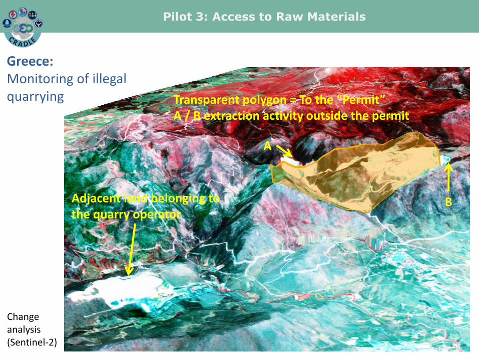
Greece: Monitoring of illegal quarrying
Mitigation of illegal quarrying activities by developing a Monitoring System with the use of EO data to track any detectable potential changes of surface morphology, land use, etc.
Validation of the status of quarrying
activities with available data by the respective authorities.
Pilot 3: Access to Raw Materials
2015 2016
2017
Transparent polygon = To the “Permit” A / B extraction activity outside the permit
A
B Adjacent land belonging to the quarry operator
Greece: Monitoring of illegal quarrying
Change analysis (Sentinel-2)

Pilot 3: Access to Raw Materials
World View 1 m resolution + 3D mapping Greece: Monitoring of illegal quarrying
Aspects of certain “quarry inspection cases” have to be based on high resolution data: Satellite or UAV.
Acquisition of 3D data may also be required using satellite or UAV airborne photogrammetry.

Pilot 3: Access to Raw Materials
Greece: Monitoring of illegal quarrying
Image classification: Sizes of extraction activity can be quantified
EO tools assist in mapping & monitoring surface quarrying activity.
Pilot 3: Access to Raw Materials
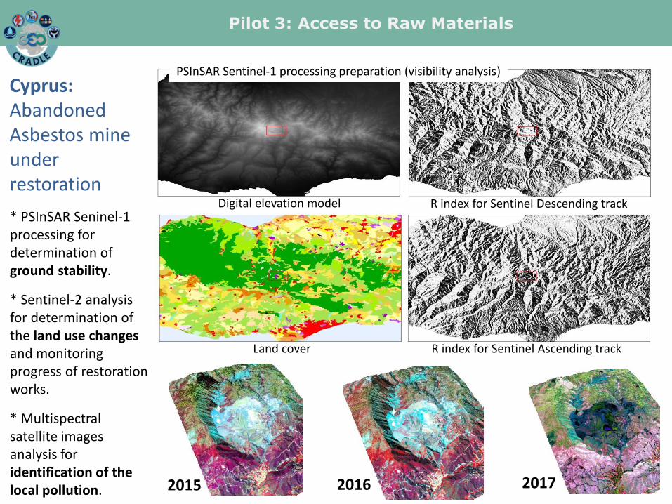
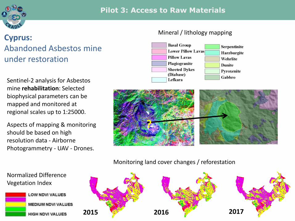
Cyprus: Abandoned Asbestos mine under restoration
Digital elevation model R index for Sentinel Descending track
R index for Sentinel Ascending track Land cover
PSInSAR Sentinel-1 processing preparation (visibility analysis)
2015 2017 2016
* PSInSAR Seninel-1 processing for determination of ground stability.
* Sentinel-2 analysis for determination of the land use changes and monitoring progress of restoration works.
* Multispectral satellite images analysis for identification of the local pollution.
Pilot 3: Access to Raw Materials
Cyprus: Abandoned Asbestos mine under restoration
Sentinel-2 analysis for Asbestos mine rehabilitation: Selected biophysical parameters can be mapped and monitored at regional scales up to 1:25000.
Aspects of mapping & monitoring should be based on high resolution data - Airborne Photogrammetry - UAV - Drones.
2015 2017 2016
Monitoring land cover changes / reforestation
D ?
Mineral / lithology mapping
Normalized Difference Vegetation Index

Pilot 3: Access to Raw Materials
Turkey 1: Iron-oxide mineralization
For iron-oxide mineralization district multispectral satellite images are used (Landsat 7 ETM+, Landsat 8 OLI, Sentinel 2) to differentiate and identify the presence of OH-FeOx anomalies and potential iron zones and other polymetallic mineralization, specific alteration minerals, often indicators of mineralization in subsurface, which in turn helps mining companies to focus on areas for further exploration (prior to expensive conventional methods such as trenching and drilling), thereby reducing fieldwork and minimizing environmental impact.

Pilot 3: Access to Raw Materials
Turkey 1: Iron-oxide mineralization
2015
Different image products are evaluated in terms of: 1. Contribution to geologic mapping 2. Mapping of the various mining sites 3. Monitoring the mining areas
2017
Enhanced images can be viewed as stereo using Anaglyph 3D Glasses
Multi-temporal mapping of changes in the Kirikkale mining area
Pilot 3: Access to Raw Materials
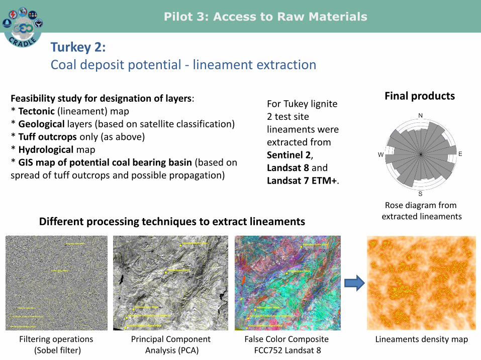
Turkey 2: Coal deposit potential - lineament extraction
Feasibility study for designation of layers: * Tectonic (lineament) map * Geological layers (based on satellite classification) * Tuff outcrops only (as above) * Hydrological map * GIS map of potential coal bearing basin (based on spread of tuff outcrops and possible propagation)
Filtering operations (Sobel filter)
Principal Component Analysis (PCA)
False Color Composite FCC752 Landsat 8
Lineaments density map
Rose diagram from extracted lineaments Different processing techniques to extract lineaments
Final products For Tukey lignite 2 test site lineaments were extracted from Sentinel 2, Landsat 8 and Landsat 7 ETM+.

Closer collaboration was established with the following end-users so far:
• Ministry of Environment and Energy of Greece: a close collaboration has started in order to implement the pilot project on mitigation of illegal quarrying.
• GSD-FD-Ministry of Agriculture, Rural Development and Environment of Cyprus: the scope of the feasibility study for monitoring of ground deformation and stability in the Asbestos Mine under restoration was established.
• Hellenic Copper Mines Ltd and Ministry of Agriculture, Rural Development and Environment of Cyprus: the exchange of information on environmental monitoring before the closure of the mine and the possible use of EO data for Skourriotissa Village area can lead to future collaboration with the Geological Survey of Cyprus.
Experimental campaigns from which data will be integrated 2
Pilot 3: Access to Raw Materials

Pilot 4: Access to Solar Energy
Objectives
• Coordination of regional EO capacities & research activities (including Copernicus Space & Service Segment initiatives) for an operational, satellite-driven, real-time system for solar energy now-cast.
• Long term solar energy atlases for various areas with high temporal and spatial detail.
• Solar radiation related products (real time and forecasts) related with: health (UV Index - melanoma, DNA damage, cataract, Vitamin D efficiency), agriculture (photosynthesis), scientific…

Pilot 4: Access to Solar Energy
SENSE inputs Satellite Data Copernicus Atmospheric Monitoring Service Radiative Transfer models Neural networks, Multilinear functions, machine learning
SENSE: a Solar Energy Nowcasting and forecasting SystEm + solar energy long-term analysis
SENSE products use

Pilot 4: Access to Solar Energy
State-of-the art, progress, achievements, impact
• Egyptian Ministry of Electricity and Renewable Energy: a common website was developed in which the real-time and climatological solar energy products of SENSE are disseminated. Αn analytical Egyptian solar atlas was presented in the regional workshop in Cairo (May 2017).

Pilot 4: Access to Solar Energy
• Greek Independent Power Transmission Operator: a close collaboration in order to update their nowcasting and forecasting power systems with the SENSE's state-of-the-art methods. They exploit the real-time solar energy maps and data (60K pixels/integrated energy values every 15-minutes) by comparing them with real solar farms and controlling the local energy demands.

Pilot 4: Access to Solar Energy
• Pre-tect international campaign: the solar energy maps of Crete were provided in real-time for the purposes of the campaign (April 2017) and spectral comparisons with a high precision solar spectroradiometer (PSR) are made to further validate the SENSE under high-aerosol loads.

Pilot 4: Access to Solar Energy
• Attica group with Bluestar and superfast ferries, Greece: for the pilot period they attract relevant ads in order to efficiently advertise the real-time UV-index service from SENSE through the monitors of their ships with routes to the Aegean and the Adriatic seas.
Pilot 4: Access to Solar Energy
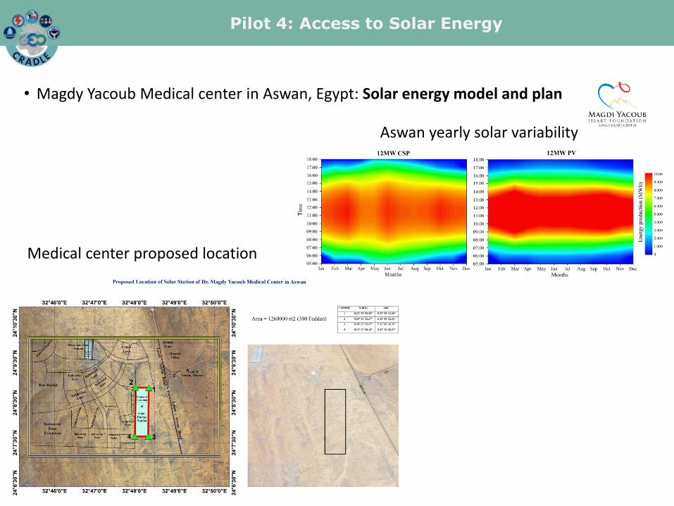
• Magdy Yacoub Medical center in Aswan, Egypt: Solar energy model and plan
Aswan yearly solar variability
Medical center proposed location
Pilot 4: Access to Solar Energy
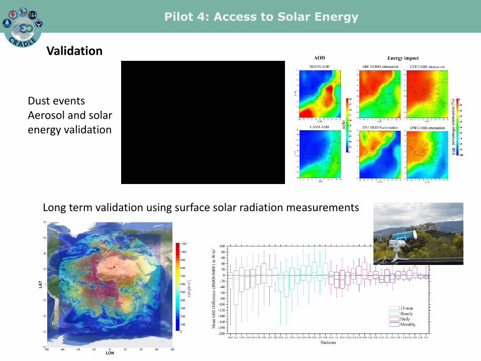
Dust events Aerosol and solar energy validation
Long term validation using surface solar radiation measurements
Validation
Pilot 4: Access to Solar Energy
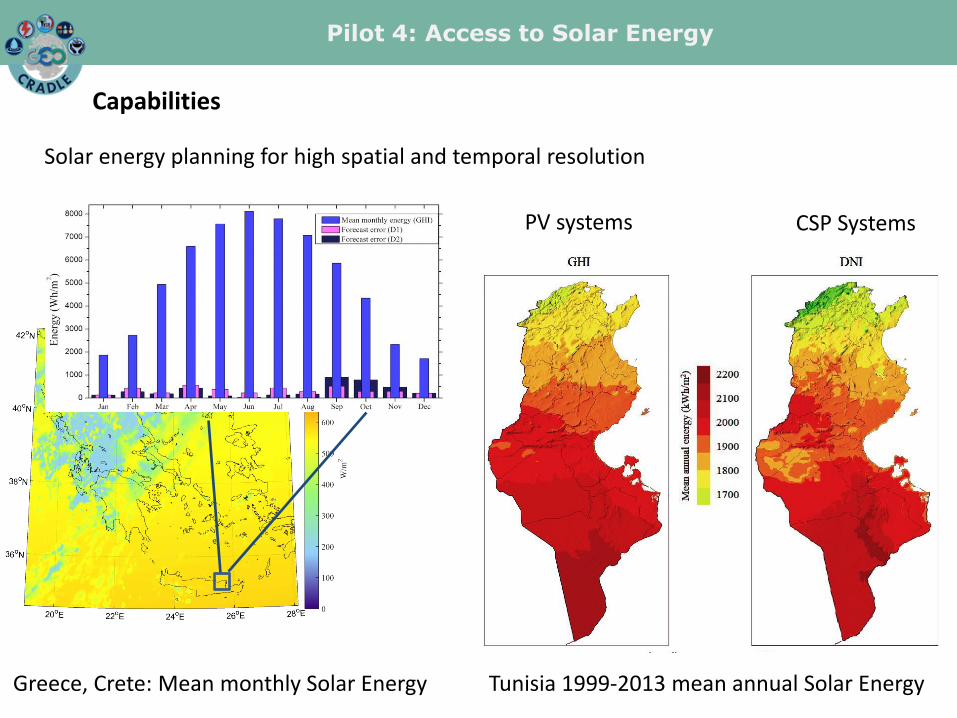
Capabilities
Solar energy planning for high spatial and temporal resolution
Tunisia 1999-2013 mean annual Solar Energy
PV systems CSP Systems
Greece, Crete: Mean monthly Solar Energy

Pilot 4: Access to Solar Energy
Capabilities
Solar energy planning for high spatial and temporal resolution SENSE can be implemented anywhere - tailored products • Identify common calls for projects (e.g. GMES in Africa, AfriGEOSS, and
future EuroGEOSS)
• Capacity building
• Continuation of the collaboration with Mediterranean countries
Forecasting solar variability Energy storage Production distribution Demand management

Collaboration and extensive cooperation with the following end-users so far:
• Egyptian Ministry of Electricity and Renewable Energy.
• Greek Independent Power Transmission Operator.
• Pre-tect international campaign.
• Attica group with Bluestar and superfast ferries, Greece.
• Magdy Yacoub Medical center in Aswan, Egypt.
Experimental campaigns from which data will be integrated 2
Spin-off and R&D projects built on this GEO-CRADLE pilot 2 (EOENABLER, Solea)
Pilot 4: Access to Solar Energy
