geo-hydrological study of watershed gv-41, shivana … · · 2016-09-09swati g bainade1, soham n...
TRANSCRIPT
International Journal of Scientific & Engineering Research, Volume 4, Issue 12, December-2013 ISSN 2229-5518
IJSER © 2013
http://www.ijser.org
Geo-Hydrological Study of Watershed GV-41, Shivana River Basin Using Remote
Sensing and GIS Techniques Swati G Bainade1, Soham N Davhale2, Ashok V. Tejankar3
ABSTRACT - As we know that Deccan Trap having the multiaquifer system and heterogeneous in nature of basalts. In an effort to maintain
the water table condition in balance, artificial recharge schemes are being implemented in various parts of the world. The selection of sites
for artificial recharge is a very important task in recharge studies. The occurrence and movement of groundwater in hard-rock terrain are
controlled by secondary porosities developed through weathering and fracturing. Groundwater occurs in the weathered residual under
unconfined conditions and circulates through fractures and fissures below. Here the aquifers are characteristically discontinuous. The
presence of buried pediments and palaeochannels offer good sources of water with lineaments. The present study aims at siting artificial
recharge structures in the hard-rock terrain of the Shivna river basin in the Aurangbad district of Maharashtra, India, where the average
annual rainfall is 650mm. In this investigation, integrated remote sensing and GIS techniques were used. Various parameters l ike lithology,
structure, landcover /landuse, aspects of drainage, basins, landforms and other parameters were extracted from visual interpretation of
IRS_P6 Satellite data and Survey of India (SOI) topographical sheets, aided by field checks. The depth of weathered material, water table
conditions, and rainfall data were been considered. All the thematic information layers were digitized and analyzed in a ArcGIS environment
and the composite maps produced show suitable sites for construction of artificial recharge structures.
Key words: Artificial recharge, GIS, Hard-rock, Remote sensing, Water table .
—————————— ——————————
1.0 Introduction:
roundwater is a dynamic and replenishable natural resource, but in hard rock terrains availability of
groundwater is of limited extent. Occurrence of groundwater in such rocks is essentially confined to fractured and weathered horizons. In Maharashtra, 83 per cent of the total geographical area is covered by hard rock formations with low porosity (less than 5 per cent) and very low (10-1 to 10-5 m/day) permeability.. Therefore, efficient management and planning of groundwater in these areas is of the utmost importance. Proper scientific planning and management require immense data to make predictions of water availability. The groundwater scenario in Maharashtra, which receives a substantial amount of annual rainfall, is not very encouraging primarily due to the imbalance between recharge and groundwater exploitation. A large amount of rain water is lost through runoff, a problem compounded by the lack of rainwater harvesting practices. Exploitation of subsurface water from deep aquifers, also deplenish resources that have taken large time span to accumulate and on which the current annual rainfall has no immediate effect. Few sustained efforts have been made to identify zones where artificial-recharge techniques can be implemented to conserve groundwater. The Deccan basalt is one such region, which faces acute shortage of
groundwater inspite of receiving high annual rainfall. Conventional hydrogeological studies would not sufficient in studying the surficial parameters of a large area to identify suitable sites for artificial-recharge because there are many controlling parameters that must be independently derived and integrated. Modern remote sensing techniques facilitate demarcation of suitable areas for groundwater replenishment by taking into account the diversity of factors that control groundwater recharge. Remote sensing has emerged as a useful tool for watershed characterization, conservation, planning and management in recent times. In the present study, the objective is to identify site-specific mechanisms for augmenting groundwater recharge in the Shivna river basins watershed GV-41 in the Aurangabad district of Maharashtra.
2.0 Materials and Methods:
2.1 Study area
The study area Fig. 1 is bounded by 74055’00”E to 75010’00”E & 19045’00”N to 20000’00”N The annual precipitation in this region is about 600mm and the post-monsoon availability of water is plentiful. The top soil cover together with the underlying weathered rock forms the upper unconfined aquifer in the area. The rain water accumulates in the unconfined aquifers with gentle to moderately sloping grounds, then it flows downstream. The available water is sufficient during the early part of the winter season (till December); later, the water table declines , and by March, many of the shallow wells tapping the upper unconfined aquifers either become dry or do not adequately meet the requirement. Thus, although there is an abundance of surface
G
————————————————
1,2 Department of Geology, Deogiri College, Aurangabad, Maharashtra, India .
3Prof. & Head, Department of Geology, Deogiri College, Aurangabad.
Maharashtra, India - 431005
Corresponding author :[email protected]
125
IJSER

International Journal of Scientific & Engineering Research, Volume 4, Issue 12, December-2013 ISSN 2229-5518
IJSER © 2013
http://www.ijser.org
water, there is still an acute shortage of water in summer. Hence, there is a need to identify regions where site-specific artificial-recharge methods can be adopted to augment water supply.
2.2 Geology
The study area comprises of volcanic rock with alternating layers of compact massive basalts and vesicular amygdaloidal basalts. Most of the region is covered with soil with an average thickness of 3m. Hence, very few rock exposures are found and these are predominantly at road cuttings and along river banks. The typical soil type observed is the medium-black-cotton variety.
Four major types of flows constitute in study area Viz. Compact Basalt Amygdaloidal Basalt Vesicular Basalt Techlytic Basalt (Red bole)
2.3 Thematic map generation:
DEM Map: Digital Elevetion Model map (refer Fig. No. 1) has been
prepared with the help of Arc-GIS 10 software. Which shows the elevation of study area having max. height of 558m in North Easterm part of study area and lowest height having 480m in southern part.
2.4 Drainage
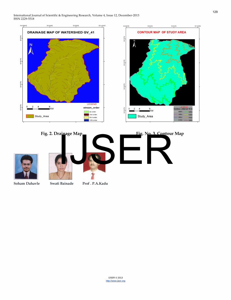
The major drainage Fig. No. 2 in the study area comprises of the NE–SW flowing and tributaries respectively. The dominant drainage pattern is parallel. The parallel drainage is due to the major fractures.. Strahler’s system of stream ordering (Strahler 1957) is used, in which the smallest finger-tip tributaries are designated as order 1st and when two 1st order channels join, a channel segment of order 2 is formed (and so on). The highest-order stream in a basin defines the order of that watershed and found to be 4th order .
2.5 Lineaments:
Lineaments in this watershed shows trend of NE-SW, which coincides with the present drainage flowing in watershed.
2.6 Contour Map:
Contour map Fig. No. 3 shows same elevation lines in study area having elevation difference of 88m from lowest to highest.
3.0 Results and discussions:
Occurrence of groundwater is governed by multiple parameters. Hence in the present study, using remote sensing data, surface and ground truth data, subsurface features were mapped. The derived map was validated with the available water level data and the same shows that as the potentiality decreases, the water level also decreases. Hence it is evident that modern tools like remote sensing and GIS can be effectively used in targeting artificial groundwater recharge sites.
3.1 Recommended recharge structures
Artificial techniques for recharge would be effective in study area & they are chosen in accordance with the specific site conditions. In the present study, suitable recharge structures such as percolation ponds, check dams are recommended based on the drainage morphology in the areas demarcated as favourable for artificial-recharge for watershed GV-41.
4.0 Conclusion:
As Remote Sensing and GIS has proven their credibility beyond out in natural resources. An attempt has made to identify artificial recharge sites of the study area. An integrated maps has been derived showing artificial recharge sites which were reclassified into Most Suitable, Good Suitable, Moderately Suitable, Poor & Not Suitable.
Detailed image interpretation was carried out and various
thematic maps were prepared. Satellite image were georeferenced and rectified using IGIS 1.1 and other thematic maps were prepared by using ArcGIS 10. In spite of the fact that the study area is dominated by hard rock basalts, which are generally known to be poor aquifers, the moderate to high degree of weathering, moderate density of joints, fractures and flow contacts are the favorable sites for groundwater occurrences.
The study has shown that the integrated spatial
information analysis using parameters of geology, geomorphology, soil, landuse and landcover, slope, drainage and lineament density, frequency and intersections along with remotely sensed data has great promise and potential for identifying and delineating the favorable zones for exploration and artificial recharges.
References :
1. Tewodros Rango Godebo, 2005 ‘Application of remote sensing and GIS for geological investigation and groundwater potential zone identification, south eastern Ethiopian pleatue, Bale mountains and surrounding areas’ report submitted to Addis Ababa University, Ethiopia.
2. Akram Javed et al., 2009 ‘Delineation of groundwater potential zones in Kakund watershed, eastern Rajasthan, using remote sensing and GIS technique’, Journal of geological society of India, Vol. 73, p. 229-236.
3. Dr. A.V.Tejankar, Soham N Davhale, Dr. N. S. Jain ‘analysis of groundwater potential with remote sensing and gis in south west part of buldhana district, maharashtra, india.’ 5th IGWC, India.
4. Dr. A.V.Tejankar, Soham N Davhale , Swati G Bainade ‘Utilisation of remote sensing and GIS for geological mapping in kurnool area, a. p., ICPCCS, Pune.
126
IJSER
International Journal of Scientific & Engineering Research, Volume 4, Issue 12, December-2013 ISSN 2229-5518
IJSER © 2013
http://www.ijser.org
5. Dr. A.V.Tejankar, Soham N Davhale , Swati G Bainade ‘Integrated approach using remote sensing and gis for delineating hydrogeomorphic features for
feature prospecting & groundwater development – a case study’ National Conference, Aurangabad.
6. Dr. Ashok V. Tejankar & Narendra S. Jain, 2012. ‘ Remote Sensing and GIS study of Geohydrological characters in landslide hazard zonation’, in International Journal, ‘Interlink Research Analysis’, ISSN 0976-0377, Vol.I, issue: V.
7. Narendra S. Jain, Dr. Ashok V. Tejankar, 2009. ‘Remote Sensing and GIS study of Geohydrological characters in landslide hazard zonation’, National conference on Groundwater auditing.
8. Deshmukh, B., Bahuguna, A., Nayak, S.R., Dhargalkar, V.K. and Jagtap, T.G.(2001) Eco, ‘geomorphological zonation of Bangaram atoll, Lakshadweep.’ Proc. ‘National Symposium on Advances in Remote Sensing Technology with Special Emphasis on High Resolution Imagery’, ISRS, Ahmedabad, India.
9. Thomas M. Lillesand, Ralph W. Kiefer “Remote Sensing and Image Interpretation” John Wiley & Sons. publication. 2008. p324.
10. Anji Reddy M ‘Textbook of Remote Sensing & Geographical Information Systems’ by B S Publication. 2012. 124-131p.
11. F. J. Pettijohn ‘Sedimentary Rocks’. CBS Publication. 177-227p.
127
IJSER

International Journal of Scientific & Engineering Research, Volume 4, Issue 12, December-2013 ISSN 2229-5518
IJSER © 2013
http://www.ijser.org
Fig. No. 1 Study Area
128
IJSER
International Journal of Scientific & Engineering Research, Volume 4, Issue 12, December-2013 ISSN 2229-5518
IJSER © 2013
http://www.ijser.org
Fig. 2. Drainage Map Fig. No. 3. Contour Map
Soham Dahavle Swati Bainade Prof . P.A.Kadu
129
IJSER