geochemistry island arc in lampung
DESCRIPTION
Geochemistry Island Arc in LampungTRANSCRIPT

TUGAS
PETROLOGI BATUAN KRISTALIN
“Geochemical Evidence of Island-Arc Origin for Sumatra Island;
A New Perspective based on Volcanic Rocks
in Lampung Province, Indonesia”
Oleh :
Rengga Bima
22015005
PROGRAM MAGISTER TEKNIK GEOLOGI
FAKULTAS ILMU DAN TEKNOLOGI KEBUMIAN
INSTITUT TEKNOLOGI BANDUNG
2016

1. INTRODUCTION
All geologists or earth scientists that ever conducted geological researches or tectonic assess-
ments about Sumatra Island in the western part of Indonesia, always classify the island as the margin of
Eurasia continent or it belongs to an active continental margin tectonic setting (Hamilton, 1979; Curray.,
1989; Barber, 2000; Barber and Crow., 2003; Crow, 2005). In Lampung Province, the most southern
province of Sumatra, volcanic products spread from the western side of the island (around Tanggamus
Volcano), through areas around Semangko Bay and continue to the east to Rajabasa Volcano and Plateau
Basalt in Sukadana area. From the above model point of view, volcanic products in this province seem to
represent the occurrences of the trench-side volcanics in the west (Tanggamus Volcano) and back arc-side
volcanic in the east (Rajabasa Volcano). However, although the both volcanoes are of the same age
(Quaternary), the volcanic products around the volcanoes are older than them ranging from Plio-
Pleistocene in the east to Oligo-Miocene in the west (figure 2).

The occurrences of both Quaternary volcanoes in two different places with significant different
distances from the subduction front are found only in Lampung, although distribution of volcanic
products from the west to the east is also recognized in the North Sumatra Province. Meanwhile, other
volcanoes on this island are concentrated only along the west coast of the island that is indicated by the
location of volcanic rock distribution on the island. The aim of this paper is to find out the tectonic setting
of the Sumatra Island based on the geochemical character of the volcanic products distributed in the
Lampung Province (figure 3).
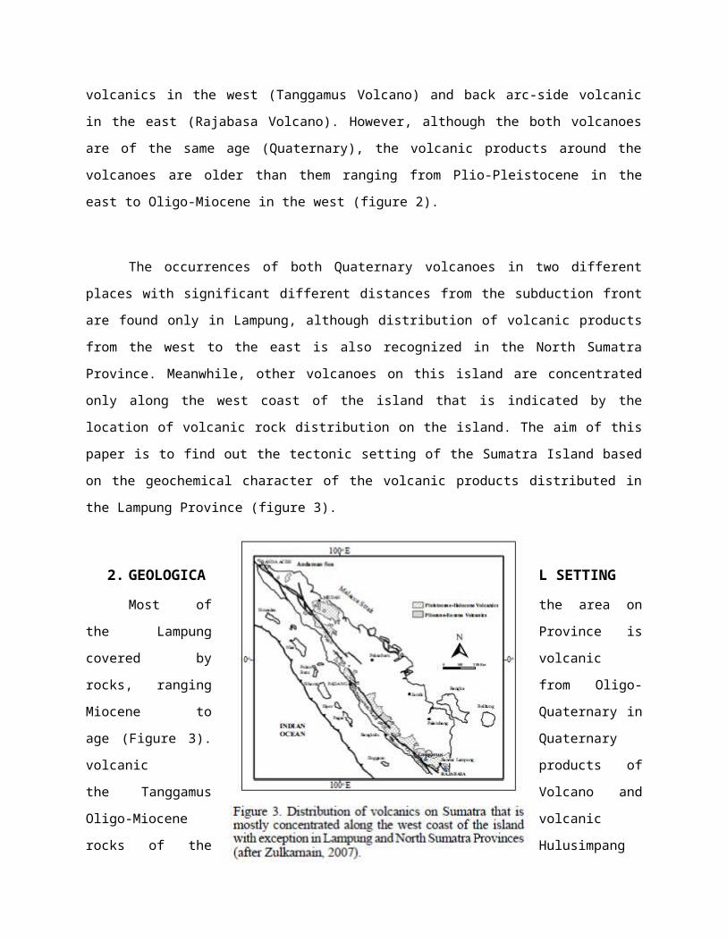
2. 2. GEOLOGICAL SETTING
Most of the area on the
Lampung Province is covered by
volcanic rocks, ranging from Oligo-
Miocene to Quaternary in age (Figure 3).
Quaternary volcanic products of the
Tanggamus Volcano and Oligo-Miocene
volcanic rocks of the Hulusimpang
Formation dominate the western part of the
province up to the central part, while
the Plio-Pleistocene volcanic products
cover almost all areas from the central
part of the province to the east (Gafoer
et.al, 1992). Among the volcanics in the eastern part, there is also Quaternary amygdaloidal basalt
spreading as black boulders throughout a wide area in Sukadana District and Quaternary Rajabasa
Volcano in the south. At certain locations along the border of both volcanic products, there are several
spotted outcrops of older rocks identified as Pre-Carboniferous metamorphic rocks and Cretaceous
intrusion. Besides the above-mentioned lithology, the area is also covered by sediments distributed in the
most western part, parallel to the coast, and in the northern part. The western area is dominated by Mio-
Pliocene tuffaceous sediments, while Plio-Pleistocene terrestrial sediments cover the northern area. In
more detail, the Tanggamus products (Quaternary volcanic rocks) in the west are composed of lava,
breccia, and tuff with basaltic to andesitic composition. Meanwhile, the Hulusimpang Formation (Oligo-
Miocene volcanic rocks) consists generally of green or greenish grey lava, breccia, and tuff with andesitic
to basaltic composition and sometimes shows sandstone intercalations. In some locations, they are
prophyllitized and mineralized. The Plio-Pleistocene volcanic products in the eastern part of the province
are lava, breccia, and tuff ranging from rhyolitic, through dacitic to andesitic in composition. Generally,
they spread with pumice and sometimes they contain carbonaceous material within. The pre-
Carboniferous metamorphic rocks consist of mica-chlorite-quartz-graphite schist, gneiss, phyllite,
quartzite, marble, and slate, while the intrusions are granitic and granodioritic in composition with several
dykes of basalt and aplite. The sediments in the western part occur as tuffaceous sandstone and mudstone,
tuff, and conglomerate containing mollusca, while the terrestrial sediments in the northern area consist of
pumiceous epiclastic sediments, tuff, sandy tuff, and tuffaceous sandstone with silicified plant. Major
geological structures in the province are faults, which belong to the Sumatra Fault System, mainly in the
western part parallel to the coast. Several minor faults are concentrated in the locations where the oldest
rocks crop out.
3. SAMPLE LOCATION AND ANALYTICAL METHOD

Around 40 relatively fresh rock samples were collected from the western and eastern
parts of the Lampung Province and twelve of them were analyzed for their major, trace, and rare
earth elements. The chemical analysis was carried out by Activation Laboratories in Canada
under analysis code 4Litho. They have developed a lithium metaborate/tetraborate fusion ICP
Whole Rock Package and a trace element ICP/MS package that are unique for scope of elements
and detection limits. The two packages are combined for Code 4Litho and Code 4Lithoresearch.
Seven samples were collected from the western area representing the Oligo-Miocene
Hulusimpang Formation and the Tanggamus Quaternary products, while five samples were
collected from the eastern area consisting of two samples from Quaternary Rajabasa Volcano
products and three samples of basalt from Sukadana and Tamiyang areas (Figure 4). The various
ages of the volcanic products in this province reflect that they were derived from different
magmatic activities and it would be used to reveal the history of their tectonic setting.
4. RESULTSa. MAJOR ELEMENTS
It is shown in the Table 1 that the western volcanic rocks contain SiO2 from 51 to
around 65 %weight, while the SiO2 content of eastern volcanic rocks ranges from 51 to
around 57 % weight. Their TiO2 content is almost similar varying from 0.67 to 1.28
%weight, but the western volcanic rocks have a wider range and are richer in Al2O3 than
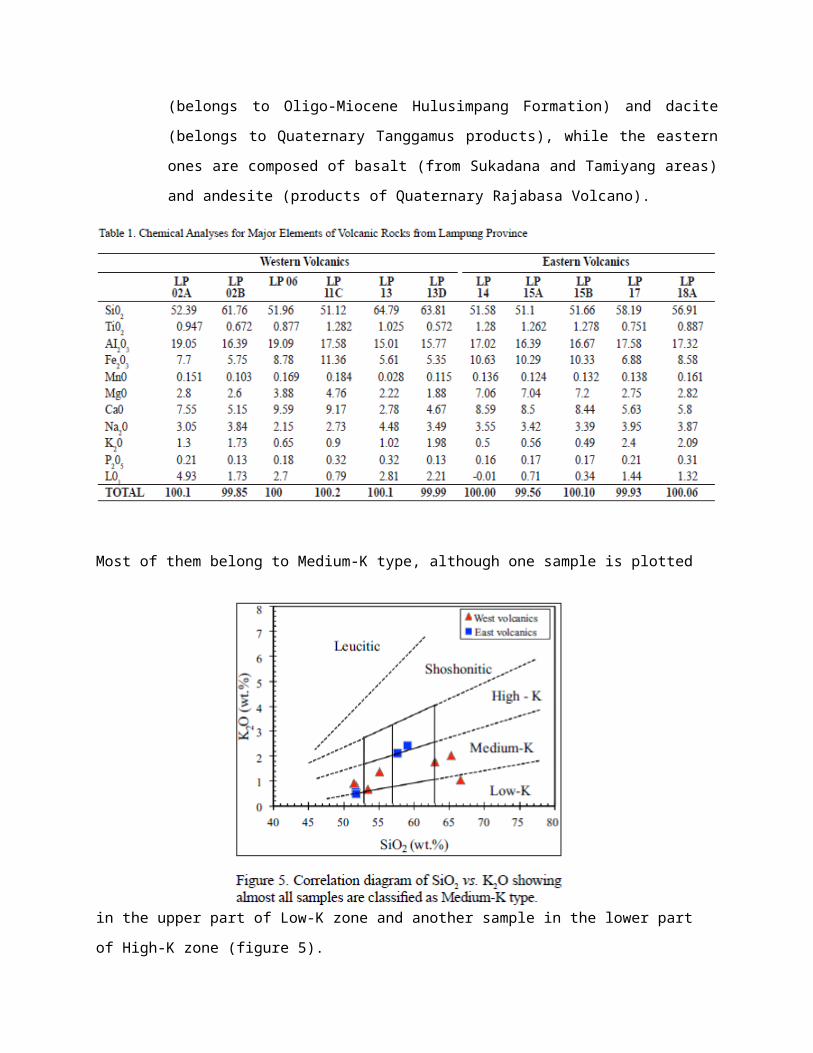
those of eastern part, as well as P2O5 content. Based on their SiO2 content, the western
volcanic rocks are classified as basalt (belongs to Oligo-Miocene Hulusimpang Formation)

and dacite (belongs to Quaternary Tanggamus products), while the eastern ones are composed
of basalt (from Sukadana and Tamiyang areas) and andesite (products of Quaternary Raja-
basa Volcano).
Most of them belong to Medium-K type, although one sample is plotted in the upper part of Low-K zone
and another sample in the lower part of High-K zone (figure 5).
On the above table, it is also seen that basalts from the eastern part (from Sukadana with sample
No. L-15A and 15B, and from Tamiyang with sample No. LP-14) contain high MgO (around 7 %
weight), while the basalts of the western volcanic contain lower MgO (around 4 % weight). However, the

western basaltic rocks show higher CaO content (around 9 % weight), whereas the eastern basalts contain
slightly lower CaO (around 8 % weight). For Fe2O3 content (total Fe is calculated as Fe2O3), basalts
from Sukadana and Tamiyang show consistent Fe2O3 content (about 10.3 % weight), but the western
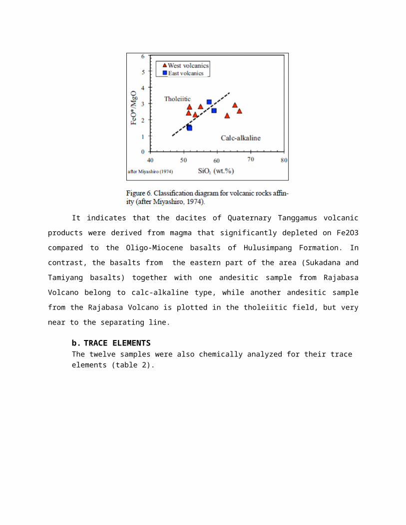
basalts show various Fe2O3 content ranging from 8.7 to 11.3 % weight. Plot of all samples in the
classification diagram of Miyashiro (1974) shows that basalts of western volcanic rocks are classified as
tholeiitic type, while the dacites from this area are plotted in the calc-alkaline field (figure 6).
It indicates that the dacites of Quaternary Tanggamus volcanic products were derived from
magma that significantly depleted on Fe2O3 compared to the Oligo-Miocene basalts of Hulusimpang
Formation. In contrast, the basalts from the eastern part of the area (Sukadana and Tamiyang basalts)
together with one andesitic sample from Rajabasa Volcano belong to calc-alkaline type, while another
andesitic sample from the Rajabasa Volcano is plotted in the tholeiitic field, but very near to the
separating line.
b. TRACE ELEMENTSThe twelve samples were also chemically analyzed for their trace elements (table 2).
The analytical results show that all rocks have higher Ba, Rb, Sr, Th, and K as well as Ti and Ce
relatively compared to MORB. It ranges from 113 to 331 ppm of Ba for the western volcanics and from
95 to 431 ppm for the eastern volcanic rocks. Rb content of the western volcanic is higher, ranging from
26.7 to 74.9 ppm, than the eastern volcanic rocks, varying from 11 to 69.6 ppm. For Sr content, the
western volcanic rocks contain lower Sr, ranging from 200 to 486 ppm, than the eastern volcanic rocks
varying from 393 to 448 ppm. Meanwhile, their Th content is almost similar, ranging from 2 to 8.1 ppm
for the western volcanic and from 1.3 to 9.9 ppm for the eastern volcanic rocks. For Potassium, the
basalts of western volcanic rocks contain higher of K varying from 5394 to 10787 ppm, while those from
eastern volcanic rocks ranging from 4066 to 4646 ppm. The intermediate and acid rocks from both areas
have K content from 8463 to 19915 ppm. In contrast with the K-content, Ti-content as well as Ni-content
of the western basalts are relatively low (5257 to 7684 ppm for Ti and from 0 to 46 ppm for Ni), while the
eastern basalts show higher Ti-content (7564 - 7672 ppm) and Ni content (160 to 170 ppm). The pattern is
found also for Cr and Co where the eastern basalts contain higher Cr and Co compared to the western
ones.

All samples are characterized by selective enrichment of incompatible elements of low ionic
potential (Sr, K, Ba, Rb, and sometimes Th), and low abundances of elements of high ionic potential (Ta,
Nb, Ce, P, Zr, Hf, Sm, Ti, Y, and Yb). All samples are plotted in spider diagrams after normalized the
elements content to MORB according to Pearce (1983). There are three different patterns of the rocks in
spider diagrams. The first pattern is characterized by a significant enrichment on the incompatible
elements (Rb and Th are enriched from around 20 to more than 50 times MORB) and having slightly
lower content on Ta and Nb compared to MORB and then slightly enriched on Ce and P (marked by
trough on Ta and Nb).
The enrichment on Ce and P ranges from 1.5 to 3 times MORB and shows a slightly variation on
other compatible elements (figure 7).
The second pattern seems to be similar with the first one, but they are enriched on incompatible
elements and differ in Ta and P contents. The pattern has higher content of Ta (higher than MORB) and
similar content of P with MORB (figure 8).
This pattern is very similar with spider diagram of Active Continental Margin or ACM (Wilson,
1989). Two dacites of western volcanic rocks (LP-02B from Tanggamus and LP-13D from Hulusimpang
Formation) and two andesites of eastern volcanic rock (LP-17 and LP-18A) belong to this pattern (figure
8 and 9).

The third pattern is characterized by slightly enrichment on incompatible elements (Rb and Th are
enriched up to 8 times of MORB content) and showing flat decreasing towards Ta, Nb, Ce, and P. They
are generally depleted on the compatible elements such as Zr, Hf, Sm, Ti, Y, and Yb (figure 10).
This pattern shows a similarity to spider diagrams of intra-continental plate basalts (Wilson,
1989). All basalt samples of eastern volcanics (from Sukadana and Tamiyang areas) represent this
pattern.

c. RARE EARTH ELEMENTS
Rare earth elements (REE) are also analyzed for the twelve samples from Lampung Province (table 3).
All REE concentrations of the samples are plotted in spider diagrams after normalizing the
contents to chondrite according to Sun & McDonough (1989). Consistently, three different patterns that
found in the spider diagrams of their trace elements are also recognized in the REE spider diagrams of the
samples.

The western volcanic rocks having island-arc character represent the first REE pattern (figure 11)
This pattern is characterized by moderate enrichment on light rare earth elements (LREE), where
La content ranges from 30 to 60 times of chondrite, and shows a relatively constant slope of decreasing
elements content towards heavy rare earth elements (HREE).

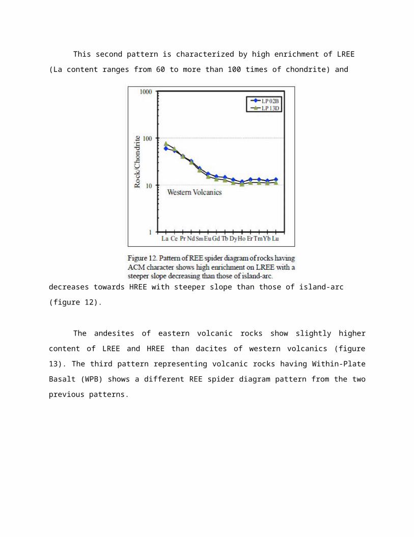
This second pattern is characterized by high enrichment of LREE (La content ranges from 60 to
more than 100 times of chondrite) and decreases towards HREE with steeper slope than those of island-
arc (figure 12).
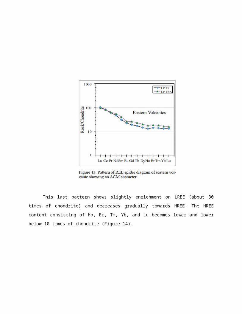
The andesites of eastern volcanic rocks show slightly higher content of LREE and HREE than
dacites of western volcanics (figure 13). The third pattern representing volcanic rocks having Within-
Plate Basalt (WPB) shows a different REE spider diagram pattern from the two previous patterns.

This last pattern shows slightly enrichment on LREE (about 30 times of chondrite) and decreases
gradually towards HREE. The HREE content consisting of Ho, Er, Tm, Yb, and Lu becomes lower and
lower below 10 times of chondrite (Figure 14).
.

5. DISCUSSION
The analyzed samples were collected from two different areas (west and east) in
Lampung Province, in order to find out the changing or variation of tectonic environment of the
volcanic products. The variation of their tectonic environment will reflect the history of the
Sumatra Island itself. In the western areas, the samples were collected from Oligo-Miocene
Hulusimpang Formation and from the Quaternary Tanggamus volcanic products. The
Hulusimpang Formation samples consist of basalt and dacite, while the Tanggamus products are
only dacites. Meanwhile, in the eastern areas, the samples were taken from Quaternary Rajabasa
Volcano products (andesite) and from Sukadana basalt plateau that is also Quaternary in age.
Plot of the volcanic rocks in the SiO2 versus K2O correlation diagram (Le Bas et al.,
1986) classifies most of the rocks as medium K type, although there is one sample is located in
the upper part of Low-K zone and another one is in the lower part of High-K zone (Figure 5).
The trend of the point distribution could not be taken into account, because they have different
age (for western volcanics) and different origin (for eastern volcanics). The unclear trend is
confirmed by plotting the samples on the Miyashiro diagram showing distribution of the western
samples in two different affinities where the basalts are classified as tholeiitic and the dacites
belong to calc alkaline affinity (Figure 6). It indicates that the western volcanic rocks were
derived from two different conditions where the dacites were crystallized from magma depleted
on iron compared to their basalts.
Comparing the composition of the Rajabasa volcanic products with the Tanggamus
products having similar age, it is found that the Rajabasa volcanics has more basic composition
(andesite) than the Tanggamus volcanics (dacite). In term of Tatsumi and Eggin’s model, the fact
indicates that both volcanic activities were derived from the recent subduction system which
places them as trench-side volcanics (Tanggamus) and back-arc volcanics (Rajabasa).
Plot of trace elements of the volcanic rocks from western areas in spider diagrams shows
two different patterns. According to Wilson, 1989, all basalt and one dacite samples show a
pattern that is similar to that of island-arc rocks (Figure 7), while the other two dacites of this
group show another pattern in spider diagram that is similar to that of Active Continental Margin
or ACM (Figure 8). The second pattern is actually not fully fit to the ACM pattern from Wilson
(1989) and it is more as a combined pattern between the pattern of island-arc and the ACM. The

samples still show lower content of Ta and Nb like an island-arc character, but they show
significant decreasing on P like the ACM pattern. However, the ACM pattern is really not a fix
pattern because it is very influenced by how much continental material that mixed into the
magma. Therefore, the second pattern of the western volcanic rocks is believed to be formed
through mixing of the island-arc magma with Eurasia continental crust with low intensity.
Plot of trace elements of the volcanic rocks from eastern areas in spider diagrams results
also in two different patterns. The first pattern shown by the andesites is very similar to the
dacite of western rocks showing a pattern of ACM character, but they have higher content of Ta
and Nb than the western rocks (Figure 9). It probably indicates that the ACM samples of the
eastern group were derived from magma containing more continental material than the western
ones. In an other word, the island-arc magma has been contaminated by more continental
materials during its ascent to the surface. The second pattern represents a pattern that is similar to
the pattern of intra-continental plate or Within-Plate Basalt (WPB). But in this case, the rock
pattern is not fully fixed with the WPB pattern, because the rocks show lower concentration of
all trace elements, except Sr and Sm (Figure 10). This pattern probably represents the rocks were
derived from basaltic magma that is very little influenced by continental materials during its
ascent to the surface.
The three different patterns representing three different tectonic environments during
their generation that are recognized through their trace elements spider diagrams can also be
found in their REE spider diagrams. The island-arc type rocks are characterized by moderate
enrichment of La (up to 60 times of chondrite) and decrease in constant slope to HREE (with Lu
about 10 times of chondrite). The western rocks with island-arc character show different
fractionation stages indicated by constant increasing of their REE ratio to chondrite (Figure 11).
Meanwhile, the western and eastern volcanic rocks having ACM character are characterized by
high enrichment of La (60 to 100 times of chondrite) and decrease with steeper slope than the
island-arc towards Ho and continue to Lu with almost constant ratio with chondrite for Er Tm
and Yb (Figure 12 and 13). The high enrichment of LREE of these rocks indicates that the
magma was mixed with continental materials which were rich on elements of LREE. The ACM
patterns of western and eastern volcanic rocks reveal that the eastern rocks are derived from
more contaminated magma than the western ones. It is indicated by the higher ratio of LREE and
HREE to chondrite of the eastern rocks compared to the western ones. The rocks having WPB
character show also a certain pattern where the rocks are enriched insignificantly on LREE (with
La up to 30 times of chondrite). The LREE decrease almost constantly towards HREE with Ho,
Er, Tm, Yb and Lu less than 10 times of chondrite (Figure 14).
The above results are partly confirmed by plotting all of the rocks in the Ta/Yb versus
Th/Yb diagram (Gorton & Schandl, 2000). The plot of the rocks in the diagram classifies them
into types of oceanic-arc, ACM and Within Plate Volcanic Zone (Figure 15).
Almost all of the western rocks with island-arc character are plotted along the line
separating oceanic-arc and ACM as well as the western and eastern rocks showing ACM
character. It indicates that the diagram cannot be separated clearly between island-arc and ACM
rocks, but it can clearly distinguish between WPB with Within Plate Volcanic Zone (WPVZ).
This classification can explain why the REE spider diagrams pattern of eastern volcanic rocks
does not fix the WPB pattern.
Besides that, the plotting of the rocks in the diagram indicates that the elements Ta, Th,
and Yb are not sensitive enough to be used as variables for discriminating the tectonic
environments.
Based on the similarity and different pattern of the island-arc and ACM characters that
are found on the above spider diagrams, the rocks are plotted in the Ta/Yb versus Ce/P. The
result can be clearly separating the three different tectonic environments (Figure 16).
The island-arc group is characterized by Ta/Yb ratio less than 2.0 and Ce/P less than 1.8.
The ACM group is recognized having Ta/Yb ratio between 2 and 4 with Ce/P more than 1.8,
while the WPVZ group is defined as a group having Ta/Yb more than 6 and Ce/P more than 1.0.
The fact shows that two dacites of western volcanic rock (samples belong to Oligo-
Miocene Hulusimpang Formation and to Quaternary Tanggamus volcanics) are ACM, which
indicates that there was a subduction system that continues from Oligo-Miocene to recent time in
the western part of Sumatra (probably close to the Sumatra Fault System/SFS) as a collision
result between an island-arc fragment with the Eurasia continental margin. However, there is a
basalt sample of the Tanggamus Volcano product that represents an island-arc character. It
indicates that probably the SFS is the zone where the Sumatra island-arc fragment collided with
the Eurasia continental margin. More statistically data from the other volcanic products towards
the north are still needed to confirm that the western part of Sumatra Island does not belong to
Eurasia continental margin, but it is actually an island-arc in origin.

6. CONCLUSIONSThe geochemical analysis using major, trace, and Rare Earth Elements of volcanic
rocks from the Lampung Province gives evidences that the Sumatra Island is not pure
part of Eurasia continental margin. Their geochemical characters reveal that the western
part of the Lampung Province is an island-arc in origin, whereas the eastern part is
definitively showing active continental margin characters. In an other word, the western
part is an island-arc and the eastern part is the margin of the Eurasian Plate. Based on the
distribution of samples with two different tectonic characters around the SFS zone, it is
interpreted that the collision zone between the Sumatra island-arc fragment with the
Eurasia continental margin is probably located along the SFS zone. It is still needed to get
more geochemical characters of the volcanic rocks along the western coast of Sumatra in
order to confirm the island-arc origin of this island.
7. REFERENCES
I Zulkarnain, 2011, Geochemical Evidence of Island-Arc Origin for Sumatra Island; A
New Perspective based on Volcanic Rocks in Lampung Province, Indonesia, Jurnal
Geologi Indonesia, Vol 6 No 4, Puslit Geotek – LIPI, Bandung