geography 12 – integrated resource package (2006) · geography 12 • acknowledgments t his...
TRANSCRIPT
IRP 068
This document represents an updating of the 1998 IRP. This updating has been undertaken for the purpose of• clarifying the Prescribed Learning Outcomes• introducing Suggested Achievement Indicators• addressing content overload
Resources previously recommended for the 1998 version of the curriculum, where still valid, continue to support this updated IRP. (See the Learning Resources section in this IRP for additional information.)
GeoGraphy 12Integrated Resource Package 2006
Library and Archives Canada Cataloguing in Publication DataMain entry under title:Geography 12 : integrated resource package 2006
Also available on the Internet. ISBN 0-7726-5531-6
1. Geography - Study and teaching (Secondary) – British Columbia. 2. Education, Secondary – Curricula – British Columbia. I. British Columbia. Ministry of Education.
G76.5.C3G46 2006 910.71’2711 C2006-960060-0
Copyright © 2006 Ministry of Education, Province of British Columbia.
Copyright NoticeNo part of the content of this document may be reproduced in any form or by any means, including electronic storage, reproduction, execution, or transmission without the prior written permission of the Province.
Proprietary NoticeThis document contains information that is proprietary and confidential to the Province. Any reproduction, disclosure, or other use of this document is expressly prohibited except as the Province may authorize in writing.
Limited Exception to Non-ReproductionPermission to copy and use this publication in part, or in its entirety, for non-profit educational purposes within British Columbia and the Yukon, is granted to (a) all staff of BC school board trustees, including teachers and administrators; organizations comprising the Educational Advisory Council as identified by Ministerial Order; and other parties providing, directly or indirectly, educational programs to entitled students as identified by the School Act, R.S.B.C. 1996, c.412, or the Independent School Act, R.S.B.C. 1996, c.216, and (b) a party providing, directly or indirectly, educational programs under the authority of the Minister of the Department of Education for the Yukon Territory as defined in the Education Act, R.S.Y. 2002, c.61.

GeoGraphy 12 • �
Acknowledgments ........................................................................................................................................................ IIIPreface ............................................................................................................................................................................. V
IntroductIon to GeoGraphy 12
Rationale ................................................................................................................................................................... 3Requirements and Graduation Credits ............................................................................................................... 3Graduation Program Examination ....................................................................................................................... 3Curriculum Organizers ......................................................................................................................................... 4Suggested Timeframe ............................................................................................................................................ 4
consIderatIons for proGram delIvery
Alternative Delivery Policy ................................................................................................................................... 7Addressing Local Contexts ................................................................................................................................... 7Involving Parents and Guardians ........................................................................................................................ 7Safety Considerations ............................................................................................................................................. 8Confidentiality ........................................................................................................................................................ 8Inclusion, Equity, and Accessibility for All Learners ........................................................................................ 8Working with the School and Community ........................................................................................................ 9Working with the Aboriginal Community ......................................................................................................... 9Information and Communications Technology ................................................................................................ 10Copyright and Responsibility .............................................................................................................................. 10Debate ...................................................................................................................................................................... 11Media Analysis ....................................................................................................................................................... 11
prescrIbed learnInG outcomes
Understanding the Prescribed Learning Outcomes .......................................................................................... 15Domains of Learning .............................................................................................................................................. 15Geography 12 Prescribed Learning Outcomes .................................................................................................. 16
student achIevement
Understanding the Key Elements ........................................................................................................................ 21Understanding the Achievement Indicators ....................................................................................................... 21Classroom Assessment and Evaluation ............................................................................................................... 22Geography 12 Key Elements and Suggested Achievement Indicators Themes and Skills ........................................................................................................................................... 25 Tectonic Processes ........................................................................................................................................... 28 Gradational Processes ..................................................................................................................................... 30 Weather and Climate ...................................................................................................................................... 32 Biomes ............................................................................................................................................................... 35 Resources and Environmental Sustainability ............................................................................................. 37
classroom assessment model
Understanding the Classroom Assessment Model ............................................................................................ 41Contents of the Model ........................................................................................................................................... 41Geography 12 Assessment Overview Table ........................................................................................................ 44
table of contents
table of contents
Geography 12 Assessment Units Themes and Skills ........................................................................................................................................... 45 Tectonic Processes ........................................................................................................................................... 55 Gradational Processes ..................................................................................................................................... 58 Weather and Climate ...................................................................................................................................... 63 Biomes ............................................................................................................................................................... 72 Resources and Environmental Sustainability ............................................................................................. 77
learnInG resources
Learning Resources and Geography 12 Grade Collection ................................................................................ 87

GeoGraphy 12 • ���
acknowledGments
This document has been updated from the 1998 IRP to include Suggested Achievement Indicators, a more clear and succinct set of Prescribed Learning Outcomes, a snapshot of the course’s Key Elements, and other minor refinements, while maintaining the original intent and essence of the 1998 curricular content.
Many people contributed their expertise to the Geography 12 IRP. The Project Manager (2005-2006) was Dr. Adrienne Gnidec of the Ministry of Education, working with other ministry personnel and our partners in education. We would like to thank all who participated in this process, including the teams of educators who developed the 1998 Geography 12 IRP, and the following individuals who contributed to the 2005-2006 updating of this document:
Ryan Earl School District No. 44 (North Vancouver)
Robert Griffith School District No. 64 (Gulf Islands)
John Hyland School District No. 57 (Prince George)
Brandi Rusk School District No. 73 (Kamloops-Thompson)
Garry Taylor School District No. 33 (Chilliwack)
Vince Warry School District No. 41 (Burnaby)
GT Publishing Services, Ltd. project coordination, writing, and editing


GeoGraphy 12 • �
preface
This Integrated Resource Package (IRP) provides basic information teachers will require in order to implement Geography 12.
This document supersedes the Geography 12 Integrated Resource Package (1998).
The information contained in this document is also available on the Internet at www.bced.gov.bc.ca/irp/irp.htm
The following paragraphs provide brief descriptions of the components of the IRP.
IntroductIon
The Introduction provides general information about Geography 12, including special features and requirements.
Included in this section are• a rationale for teaching Geography 12 in
BC schools• information about graduation program
requirements• descriptions of the curriculum organizers –
groupings for Prescribed Learning Outcomes that share a common focus
• a suggested timeframe for the course
consIderatIons for proGram delIvery
This section of the IRP contains additional information to help educators develop their school practices and plan their program delivery to meet the needs of all learners.
prescrIbed learnInG outcomes
This section contains the Prescribed Learning Outcomes, the legally required content standards for the provincial education system. The learning outcomes define the required knowledge, skills, and attitudes for each subject. They are statements of what students are expected to know and be able to do by the end of the course.
student achIevement
This section of the IRP contains information about classroom assessment and measuring student achievement, including sets of specific Suggested Achievement Indicators for each Prescribed Learning Outcome. Suggested Achievement Indicators are statements that describe what students should be able to do in order to demonstrate that they fully meet the expectations set out by the Prescribed Learning Outcomes. Suggested Achievement Indicators are not mandatory; they are provided to assist in the assessment of how well students achieve the Prescribed Learning Outcomes.
Also included in this section are Key Elements – descriptions of content that help determine the intended depth and breadth of the Prescribed Learning Outcomes.
classroom assessment model
This section contains a series of classroom units that address clusters of learning outcomes organized by topic or theme. The units, developed by BC educators, are designed to support classroom assessment. These units are suggestions only –teachers may use or modify the units to assist them as they plan for the implementation of this curriculum.
learnInG resources
This section contains general information on learning resources, and provides an Internet link to titles, descriptions, and ordering information for the recommended learning resources in the Geography 12 Grade Collection.


IntroductIonGeography 12

GeoGraphy 12 • �
IntroductIon to GeoGraphy 12
This Integrated Resource Package (IRP) sets out the provincially prescribed curriculum for Geography 12. The development of the
IRP has been guided by the principles of learning:• Learning requires the active participation
of the student.• People learn in a variety of ways and at
different rates.• Learning is both an individual and a group
process.
In addition to these three principles, this document recognizes that British Columbia’s schools include young people of varied backgrounds, interests, abilities, and needs. Wherever appropriate for this curriculum, ways to meet these needs and to ensure equity and access for all learners have been integrated as much as possible into the Prescribed Learning Outcomes, Suggested Achievement Indicators, and Classroom Assessment Model.
This document represents an updating of the 1998 IRP. This updating has been undertaken for the purpose of• clarifying the Prescribed Learning Outcomes• introducing Suggested Achievement Indicators• addressing content overload• providing teachers with additional support for
classroom-based assessment
Resources previously recommended for the 1998 version of the curriculum, where still valid, continue to support this updated IRP. (See the Learning Resources section later in this IRP for additional information.)
Geography 12, in draft form, was available for public review and response from November to December, 2005. Feedback from educators, students, parents, and other educational partners informed the development of this updated IRP.
ratIonale
Geography is a discipline that encompasses information, concepts, and methods from many fields of study. It addresses both the physical and human-created systems of the world through the study of people, places, and environments. As an ever-increasing world population puts more and
more demands on the planet’s resources, there is a need for a society that is geographically literate and therefore able to make informed decisions about the sustainability of the Earth’s resources and the future of the planet.
The geographically literate student is able to interpret the landscape and understand the interconnections between his or her actions and the Earth’s physical systems. This understanding is important in order for students to make informed decisions and take appropriate action to manage the Earth’s resources in a responsible manner. Through the study of geography, students can develop an understanding of how local, regional, and global environments affect them.
The ability to make informed decisions also requires the acquisition of relevant and practical geographic skills. Students need opportunities to analyse the critical interplay of culture, economics, politics, and social considerations when examining the relationship between people and the environment. In order to do this, students need skills in acquiring and accessing databases, in analysing and interpreting data, and in intelligently representing their findings. Because geography is an integrative discipline, these geographic skills can be applied to a wide range of potential careers.
requIrements and GraduatIon credIts
Geography 12 is designated as a four-credit course, and must be reported as such to the Ministry of Education for transcript purposes. Letter grades and percentages must be reported for this course. It is not possible to obtain partial credit for the course.
The course code for Geography 12 is GEO 12. The course is also available in French (Géographie 12; course code GEOF 12).
GraduatIon proGram examInatIon Geography 12 has an optional Graduation Program examination, worth 40% of the final course mark for students who choose to write it. Although students are not required to take this exam to receive credit for the course, they should be advised that some post-secondary institutions require

� • GeoGraphy 12
IntroductIon to GeoGraphy 12
Grade 12 exams to meet entrance requirements, and that writing Grade 12 exams also provides opportunities for provincial scholarships.
currIculum orGanIzers
A curriculum organizer consists of a set of Prescribed Learning Outcomes that share a common focus. The Prescribed Learning Outcomes for Geography 12 are grouped under six curriculum organizers. These organizers have been identified to help clarify the scope of the course and are not intended to suggest a linear delivery of course material.
Themes and SkillsThis organizer focusses on the scope and focus of geography as a discipline, with emphasis on the significance of five important geography themes (location, place, movement, regions, and human and physical interaction) and of the four spheres (atmosphere, biosphere, hydrosphere, lithosphere). It also focusses on skills that are hallmarks of geographic literacy, including representing and interpreting information using maps, various types of graphics, and technically precise language.
Tectonic ProcessesThis organizer provides opportunities for students to examine the features and processes associated with plate tectonics, with a special focus on volcanism and earthquakes and their effects.
Gradational ProcessesThis organizer provides opportunities for students to examine the processes of weathering and mass wasting. Students learn to identify physical features caused by gradation and explain the impact of the processes and features of gradation on humans.
Weather and Climate The focus of this organizer is on the factors that create our weather and shape our major climatic regions. Particular attention is devoted to how human activities affect and are affected by weather and climate.
BiomesThis organizer focusses on characteristics of the world’s major biomes. Particular attention is devoted to climate, soil, and vegetation as factors that determine the nature of biomes and to the relationship between biomes and human activity.
Resources and Environmental Sustainability This organizer provides opportunities for students to explore the considerations involved in making resource-management decisions and to examine the environmental issues associated with various human activities.
suGGested tImeframe
Provincial curricula are developed in accordance with the amount of instructional time recommended by the Ministry of Education for each subject area. Teachers may choose to combine various curricula to enable students to integrate ideas and make meaningful connections.
Geography 12 requires approximately 90 to 110 hours of instructional time. Although a four-credit course is typically equivalent to 120 hours, this timeframe allows for flexibility to address local needs.
Geography 12
Themes and Skills
Tectonic Processes
Gradational Processes
Weather and Climate
BiomesResources and Environmental Sustainability
For more information, refer to the Ministry of Education examinations web site: www.bced.gov.bc.ca/exams/

consIderatIons for proGram delIvery
Geography 12
v


GeoGraphy 12 • �
consIderatIons for proGram delIvery
This section of the IRP contains additional information to help educators develop their school practices and plan their program
delivery to meet the needs of all learners. Included in this section is information about• Alternative Delivery policy• addressing local contexts• involving parents and guardians• safety considerations• confidentiality• inclusion, equity, and accessibility for all learners • working with the school and community• working with the Aboriginal community• information and communications technology• copyright and responsibility• debate• media analysis
alternatIve delIvery polIcy
The Alternative Delivery policy does not apply to Geography 12.
The Alternative Delivery policy outlines how students, and their parents or guardians, in consultation with their local school authority, may choose means other than instruction by a teacher within the regular classroom setting for addressing Prescribed Learning Outcomes contained in the Health curriculum organizer of the following curriculum documents:• Health and Career Education K to 7,
and Personal Planning K to 7 Personal Development curriculum organizer (until September 2008)
• Health and Career Education 8 and 9• Planning 10
The policy recognizes the family as the primary educator in the development of children’s attitudes, standards, and values, but the policy still requires that all Prescribed Learning Outcomes be addressed and assessed in the agreed-upon alternative manner of delivery.
It is important to note the significance of the term “alternative delivery” as it relates to the Alternative Delivery policy. The policy does not permit schools
to omit addressing or assessing any of the Prescribed Learning Outcomes within the health and career education curriculum. Neither does it allow students to be excused from meeting any learning outcomes related to health. It is expected that students who arrange for alternative delivery will address the health-related learning outcomes and will be able to demonstrate their understanding of these learning outcomes.
For more information about policy relating to alternative delivery, refer to www.bced.gov.bc.ca/policy/
addressInG local contexts
Geography 12 includes opportunities for individual teacher and student choice in the selection of topics to meet certain learning outcomes. This flexibility enables educators to plan their programs by using topics and examples that are relevant to their local context and to the particular interests of their students. When selecting topics it may be appropriate to incorporate student input.
Where specific topics have been included in the learning outcomes, the intent is that these important issues will be addressed by all students. Issues of interest to individual school communities may also be addressed in addition to these prescribed topics.
InvolvInG parents and GuardIans
The family is the primary educator in the development of students’ attitudes and values. The school plays a supportive role by focussing on the Prescribed Learning Outcomes in the Geography 12 curriculum. Parents and guardians can support, enrich, and extend the curriculum at home.
Some of the topics dealt with in studying geography may prove sensitive for some students or parents. The topic of resource management, for instance, may elicit conflicting opinions among particular individuals or in particular communities. It is highly recommended that schools inform parents and guardians about the Geography 12

� • GeoGraphy 12
consIderatIons for proGram delIvery
curriculum, and teachers (along with school and district administrators) may choose to do so by• informing parents/guardians and students
of the Prescribed Learning Outcomes for the course
• responding to parent and guardian requests to discuss the course, unit plans, and learning resources
At the same time, being aware of experiences, views, or feelings within the community prior to teaching the course will enable teachers to make appropriate decisions about how to address the topic.
safety consIderatIons
Safety guidelines must be discussed with students. These safety guidelines must support and encourage the investigative approach, while at the same time promoting safety in the classroom and the field.
Field work and field trips require special vigilance with respect to traffic and road safety, safe practices in study areas and when obtaining samples, and an awareness of changes in weather.
Encouraging a positive safety attitude is a responsibility shared among the board, school administrators, teachers, and students in every school district. The co-operation of all these groups helps develop a strong safety consciousness both inside and outside our schools.
confIdentIalIty
The Freedom of Information and Protection of Privacy Act (FOIPPA) applies to students, to school districts, and to all curricula. Teachers, administrators, and district staff should consider the following:• Be aware of district and school guidelines
regarding the provisions of FOIPPA and how it applies to all subjects, including Geography 12.
• Do not use students’ Personal Education Numbers (PENs) on any assignments that students wish to keep confidential.
• Ensure students are aware that if they disclose personal information that indicates they are at risk for harm, then that information cannot be kept confidential.
• Inform students of their rights under FOIPPA, especially the right to have access to their own personal information in their school records. Inform parents of their rights to access their children’s school records.
• Minimize the type and amount of personal information collected, and ensure that it is used only for purposes that relate directly to the reason for which it is collected.
• Inform students that they will be the only ones recording personal information about themselves unless they, or their parents, have consented to teachers collecting that information from other people (including parents).
• Provide students and their parents with the reason(s) they are being asked to provide personal information in the context of the Geography 12 curriculum.
• Inform students and their parents that they can ask the school to correct or annotate any of the personal information held by the school, in accordance with Section 29 of FOIPPA.
• Ensure students are aware that their parents may have access to the schoolwork they create only insofar as it pertains to students’ progress.
• Ensure that any information used in assessing students’ progress is up-to-date, accurate, and complete.
For more information about confidentiality, refer to www.mser.gov.bc.ca/privacyaccess/
InclusIon, equIty, and accessIbIlIty for all learners
British Columbia’s schools include young people of varied backgrounds, interests, and abilities. The Kindergarten to Grade 12 school system focusses on meeting the needs of all students. When selecting specific topics, activities, and resources to support the implementation of Geography 12, teachers are encouraged to ensure that these choices support inclusion, equity, and accessibility for all students. In particular, teachers should ensure that classroom instruction, assessment, and resources reflect sensitivity to diversity and incorporate positive role portrayals, relevant issues, and themes such as inclusion, respect, and acceptance.

GeoGraphy 12 • �
consIderatIons for proGram delIvery
Government policy supports the principles of integration and inclusion of students for whom English is a second language and of students with special needs. Most of the Prescribed Learning Outcomes in this IRP can be met by all students, including those with special needs and/or ESL needs. Some strategies may require adaptations to ensure that those with special and/or ESL needs can successfully achieve the learning outcomes. Where necessary, modifications can be made to the Prescribed Learning Outcomes for students with Individual Education Plans (IEPs).
For more information about resources and support for students with special needs, refer to www.bced.gov.bc.ca/specialed/
For more information about resources and support for ESL students, refer to www.bced.gov.bc.ca/esl/
workInG wIth the school and communIty
This curriculum addresses a wide range of skills and understandings that students are developing in other areas of their lives. It is important to recognize that learning related to this curriculum extends beyond the Geography 12 classroom.
School and district-wide programs and community organizations may support and extend learning in Geography 12 through the provision of locally developed learning resources, guest speakers, workshops, and field studies. Teachers may wish to draw on the expertise of these community organizations and members.
Bringing outside resource people into the classroom is an effective way of reinforcing content, emphasizing and practising listening skills, exposing students to diverse points of view, providing opportunities for discussion and debate, providing a departure point for writing and other activities, and making learning more concrete and relevant. A panel discussion also provides an opportunity for several viewpoints on an issue to be presented at the same time.
To help achieve a successful guest speaker activity, consider the following:• Determine the nature of the presentation (e.g.,
lecture, question-and-answer, debate, response to students’ presentations, facilitating a simulation or case study). Ensure that guest speakers are clear about their purpose, the structure, and the time allotted. The content of the presentation should directly relate to the Prescribed Learning Outcomes. Review any materials speakers may use, especially any handouts, for appropriateness.
• Be aware of any district guidelines for external presenters, and ensure that guests have met these guidelines.
• Where appropriate, have students take responsibility for contacting the speaker(s) beforehand and making any logistical arrangements.
• Provide time for students to prepare for the guest speaker or panel by formulating focus questions.
• Begin the guest speaker presentation with an introduction to the topic and end with a debrief.
workInG wIth the aborIGInal communIty
The Ministry of Education is dedicated to ensuring that the cultures and contributions of Aboriginal peoples in BC are reflected in all provincial curricula. To address these topics in the classroom in a way that is accurate and that respectfully reflects Aboriginal concepts of teaching and learning, teachers are strongly encouraged to seek the advice and support of local Aboriginal communities. Aboriginal communities are diverse in terms of language, culture, and available resources, and each community will have its own unique protocol to gain support for integration of local knowledge and expertise. To begin discussion of possible instructional and assessment activities, teachers should first contact Aboriginal education co-ordinators, teachers, support workers, and counsellors in their district who will be able to facilitate the identification of local resources and contacts such as elders, chiefs, tribal or band councils, Aboriginal cultural centres, Aboriginal Friendship Centres, and Métis or Inuit organizations.

10 • GeoGraphy 12
consIderatIons for proGram delIvery
In addition, teachers may wish to consult the various Ministry of Education publications available, including the “Planning Your Program” section of the resource, Shared Learnings. This resource was developed to help all teachers provide students with knowledge of, and opportunities to share experiences with, Aboriginal peoples in BC.
For more information about these documents, consult the Aboriginal Education web site: www.bced.gov.bc.ca/abed/welcome.htm
InformatIon and communIcatIons technoloGy
The study of information and communications technology is increasingly important in our society. Students need to be able to acquire and analyse information, to reason and communicate, to make informed decisions, and to understand and use information and communications technology for a variety of purposes. Development of these skills is important for students in their education, their future careers, and their everyday lives.
Literacy in the area of information and communications technology can be defined as the ability to obtain and share knowledge through investigation, study, instruction, or transmission of information by means of media technology. Becoming literate in this area involves finding, gathering, assessing, and communicating information using electronic means, as well as developing the knowledge and skills to use and solve problems effectively with the technology. Literacy also involves a critical examination and understanding of the ethical and social issues related to the use of information and communications technology. When planning for instruction and assessment in Geography 12, teachers should provide opportunities for students to develop literacy in relation to information and communications technology sources, and to reflect critically on the role of these technologies in society.
copyrIGht and responsIbIlIty
Copyright is the legal protection of literary, dramatic, artistic, and musical works; sound recordings; performances; and communications signals.
Copyright provides creators with the legal right to be paid for their work and the right to say how their work is to be used. The law permits certain exceptions for schools (i.e., specific things permitted) but these are very limited, such as copying for private study or research. The copyright law determines how resources can be used in the classroom and by students at home.
In order to respect copyright it is necessary to understand the law. It is unlawful to do the following, unless permission has been given by a copyright owner:• photocopy copyrighted material to avoid
purchasing the original resource for any reason• photocopy or perform copyrighted material
beyond a very small part – in some cases the copyright law considers it “fair” to copy whole works, such as an article in a journal or a photograph, for purposes of research and private study, criticism, and review
• show recorded television or radio programs to students in the classroom unless these are cleared for copyright for educational use (there are exceptions such as for news and news commentary taped within one year of broadcast that by law have record-keeping requirements – see the web site at the end of this section for more details)
• photocopy print music, workbooks, instructional materials, instruction manuals, teacher guides, and commercially available tests and examinations
• show videorecordings at schools that are not cleared for public performance
• perform music or do performances of copyrighted material for entertainment (i.e., for purposes other than a specific educational objective)
• copy work from the Internet without an express message that the work can be copied
Permission from or on behalf of the copyright owner must be given in writing. Permission may also be given to copy or use all or some portion of copyrighted work through a licence or agreement. Many creators, publishers, and producers have formed groups or “collectives” to negotiate royalty payments and copying conditions for educational
GeoGraphy 12 • 11
consIderatIons for proGram delIvery
institutions. It is important to know what licences are in place and how these affect the activities schools are involved in. Some licences may also require royalty payments that are determined by the quantity of photocopying or the length of performances. In these cases, it is important to assess the educational value and merits of copying or performing certain works to protect the school’s financial exposure (i.e., only copy or use that portion that is absolutely necessary to meet an educational objective).
It is important for education professionals, parents, and students to respect the value of original thinking and the importance of not plagiarizing the work of others. The works of others should not be used without their permission.
For more information about copyright, refer to www.cmec.ca/copyright/indexe.stm
debate
Formal debate is one of the fundamental activities of democracy and, through various international organizations such as the United Nations, is also a tool for resolution of global problems and issues. Debate provides opportunities for students to integrate knowledge and communication skills, and allows for critical examination of differing viewpoints. Debate can be used at the beginning of a unit of study on a particular topic (to explore students’ pre-existing knowledge and attitudes on the issue), and/or at the end of a unit of study (to summarize and represent learning).
Various forms and forums of debate are appropriate in Geography 12 classes. Examples of relevant debate forms include• informal classroom debate• formal debate styles (e.g., Oxford, Lincoln-
Douglas, Cross-Examination)• model parliaments, model UN• round table discussions• mock trials• town hall forums• online forums
medIa analysIs
Much of the information that the public receives about issues and events is received through media messages – in newspapers and magazines, on television and radio, and on the Internet. Analysis of media messages is a valuable component of Geography 12, and allows students to think critically and independently about issues that affect them.
The following concepts of media education are examples of the ways in which teachers and students can examine a range of media messages relevant to Geography 12:• Purpose: People use media messages to inform,
entertain, and/or persuade for political, commercial, educational, artistic, moral, and/or other purposes.
• Values: Media messages communicate explicit and implicit values.
• Representation: Media messages are constructed; they are only representations of real or imaginary worlds.
• Codes, Conventions, and Characteristics: Each medium has its own set of codes, conventions, and characteristics that affect the way messages are transmitted and understood.
• Production: People who understand the media are better able to make purposeful media messages.
• Interpretation: Audience members bring their knowledge, experience, and values to their interpretation of and emotional response to media messages.
• Influence of Media on Audience: Media messages can influence people’s attitudes, behaviours, and values.
• Influence of Audience on Media: People can influence media institutions and the messages they produce and transmit.
• Control: People who control a society’s dominant institutions have disproportionate influence on the construction and distribution of media messages and the values they contain.
• Scope: Media technologies influence and are influenced by the political, economic, social, and intellectual dimensions of societies.


prescrIbed learnInG outcomes
Geography 12


prescrIbed learnInG outcomes
GeoGraphy 12 • 15
Prescribed Learning Outcomes are content standards for the provincial education system; they are the prescribed curriculum.
Clearly stated and expressed in measurable and observable terms, learning outcomes set out the required knowledge, skills, and attitudes – what students are expected to know and be able to do – by the end of the specified course.
understandInG the prescrIbed learnInG outcomes
Schools have the responsibility to ensure that all Prescribed Learning Outcomes in this curriculum are met; however, schools have flexibility in determining how delivery of the curriculum can best take place.
It is expected that student achievement will vary in relation to the learning outcomes. Evaluation, reporting, and student placement with respect to these outcomes are dependent on the professional judgment and experience of teachers, guided by provincial policy.
Prescribed Learning Outcomes for Geography 12 are presented by curriculum organizer, and are coded alphanumerically for ease of reference; however, this arrangement is not intended to imply a required instructional sequence.
Wording of the Prescribed Learning OutcomesAll learning outcomes complete the stem, “It is expected that students will….”
When used in a Prescribed Learning Outcome, the word “including” indicates that any ensuing item must be addressed. Lists of items introduced by the word “including” represent a set of minimum requirements associated with the general requirement set out by the outcome. The lists are not necessarily exhaustive, however, and teachers may choose to address additional items that also fall under the general requirement set out by the outcome.
domaIns of learnInG
Prescribed Learning Outcomes in BC curricula identify required learning in relation to one or more of the three domains of learning: cognitive, psychomotor, and affective. The following definitions of the three domains are based on Bloom’s taxonomy.
The cognitive domain deals with the recall or recognition of knowledge and the development of intellectual abilities. The cognitive domain can be further specified as including three cognitive levels: knowledge, understanding and application, and higher mental processes. These levels are determined by the verb used in the learning outcome, and illustrate how student learning develops over time.• Knowledge includes those behaviours that
emphasize the recognition or recall of ideas, material, or phenomena.
• Understanding and application represents a comprehension of the literal message contained in a communication, and the ability to apply an appropriate theory, principle, idea, or method to a new situation.
• Higher mental processes include analysis, synthesis, and evaluation. The higher mental processes level subsumes both the knowledge and the understanding and application levels.
The affective domain concerns attitudes, beliefs, and the spectrum of values and value systems.
The psychomotor domain includes those aspects of learning associated with movement and skill demonstration, and integrates the cognitive and affective consequences with physical performances.
Domains of learning and cognitive levels also form the basis of the Assessment Overview Table provided in the Classroom Assessment Model. In addition, domains of learning and, particularly, cognitive levels, inform the design and development of the optional Graduation Program examination for this course.
prescrIbed learnInG outcomes
16 • GeoGraphy 12
Prescribed Learning Outcomes: Geography 12
It is expected that students will:
themes and skIlls
A1 explain the following five themes of geography:− location− place− movement− regions− human and physical interaction
A2 describe the major interactions of the four spheres:− atmosphere− biosphere− hydrosphere− lithosphere
A3 demonstrate geographic literacy through− analysis of geographic data or information to assess reliability and identify trends and
relationships− interpretation of topographic maps and aerial and satellite images− description of the role of geography as a discipline
A4 apply effective written, oral, and graphic communication skills to geography topicsA5 describe the geographic applications of current information and imaging technologies
tectonIc processes
B1 describe the features and processes associated with plate tectonics, including− the Earth’s layers− volcanism− folding and faulting− earthquakes
B2 explain the effects of volcanism and earthquakes
GradatIonal processes
C1 describe the features and processes associated with weathering and mass wastingC2 describe the features and processes associated with
− running water− ground water− glaciers− wind− waves
C3 assess the effects of gradation on humans

prescrIbed learnInG outcomes
GeoGraphy 12 • 1�
Prescribed Learning Outcomes: Geography 12
weather and clImate D1 describe the characteristics and significance of the layers of the atmosphere, including
− troposphere− stratosphere
D2 explain factors affecting temperature, precipitation, pressure, and windD3 analyse specific weather phenomena, including
− fog− local winds− extreme events
D4 interpret information from weather maps and station modelsD5 describe the characteristics of the world’s climate regions, including
− equatorial− tropical wet/dry− Mediterranean− desert− continental interior− humid continental (including humid sub-tropical)− west coast marine− sub-arctic− tundra
D6 explain how climate affects human activityD7 analyse interactions between human activity and the atmosphere, with reference to
− global climate change− ozone depletion− acid precipitation
bIomes
E1 outline characteristics of the Earth’s major biomes, including− tropical rainforest− tropical grasslands/savanna− Mediterranean/schlerophyll− desert− temperate grasslands/prairie/steppe− deciduous/mixed forest− temperate rainforest− coniferous forest/boreal/taiga− tundra
E2 describe how vegetation adapts to environmental conditionsE3 relate soil types to biomesE4 analyse the interactions between human activity and biomes, with reference to
− deforestation− desertification− soil degradation− species depletion
prescrIbed learnInG outcomes
1� • GeoGraphy 12
Prescribed Learning Outcomes: Geography 12
resources and envIronmental sustaInabIlIty
F1 assess the various considerations involved in resource management, including− sustainability− availability− social/cultural consequences− economic consequences− political consequences
F2 assess the environmental impact of human activities, including− energy production and use− forestry− fishing− mining− agriculture− waste disposal− water use

student achIevement
Geography 12


GeoGraphy 12 • 21
student achIevement
This section of the IRP contains information about classroom assessment and student achievement, including specific achievement
indicators to assist in the assessment of student achievement in relation to each Prescribed Learning Outcome. Also included in this section are Key Elements – descriptions of content that help determine the intended depth and breadth of Prescribed Learning Outcomes.
understandInG the key elements
Key Elements provide an overview of content in each curriculum organizer. They can be used to determine the expected depth and breadth of the Prescribed Learning Outcomes.
understandInG the achIevement IndIcators
To support the assessment of provincially prescribed curricula, this IRP includes sets of achievement indicators in relation to each learning outcome. The achievement indicators are arranged by curriculum organizer; however, this order is not intended to imply a required sequence of instruction and assessment.
Achievement indicators define the specific level of knowledge acquired, skills applied, or attitudes demonstrated by the student in relation to a corresponding Prescribed Learning Outcome. They describe what evidence to look for to determine whether or not the student has fully met the intent of the learning outcome. Since each achievement indicator defines only one aspect of the corresponding learning outcome, the entire set of achievement indicators should be considered when determining whether students have fully met the learning outcome.
In some cases, achievement indicators may also include suggestions as to the type of task that would provide evidence of having met the learning outcome (e.g., a constructed response such as a list, comparison, analysis, or chart; a product created and presented such as a report, debate, poster, letter, or model; a particular skill demonstrated such as questioning).
Achievement indicators support the principles of assessment for learning, assessment as learning, and assessment of learning. They provide teachers and parents with tools that can be used to reflect on what students are learning, as well as provide students with a means of self-assessment and ways of defining how they can improve their own achievement.
Achievement indicators are not mandatory; they are suggestions only, provided to assist in the assessment of how well students achieve the Prescribed Learning Outcomes.
Achievement indicators may be useful to provincial examination development teams and inform the development of exam items. However, examination questions, item formats, exemplars, rubrics, or scoring guides will not necessarily be limited to the achievement indicators as outlined in the Integrated Resource Packages.
Specifications for provincial examinations are available online at www.bced.gov.bc.ca/exams/specs/
22 • GeoGraphy 12
student achIevement
classroom assessment and evaluatIon
Assessment is the systematic gathering of information about what students know, are able to do, and are working toward. Assessment evidence can be collected using a wide variety of methods, such as• observation• student self-assessments and peer assessments• quizzes and tests (written, oral, practical)• samples of student work• projects and presentations• oral and written reports• journals and learning logs• performance reviews• portfolio assessments
Assessment of student achievement is based on the information collected through assessment activities. Teachers use their insight, knowledge about learning, and experience with students, along with the specific criteria they establish, to make judgments about student performance in relation to Prescribed Learning Outcomes.
Three major types of assessment can be used in conjunction to support student achievement.• Assessment for learning is assessment for
the purpose of greater learning achievement.• Assessment as learning is assessment as a
process of developing and supporting students’ active participation in their own learning.
• Assessment of learning is assessment for the purpose of providing evidence of achievement for reporting.
Assessment for LearningClassroom assessment for learning provides ways to engage and encourage students to become involved in their own day-to-day assessment – to acquire the skills of thoughtful self-assessment and to promote their own achievement.
This type of assessment serves to answer the following questions:• What do students need to learn to be successful?• What does the evidence of this learning
look like?
Assessment for learning is criterion-referenced, in which a student’s achievement is compared to established criteria rather than to the performance of other students. Criteria are based on Prescribed Learning Outcomes, as well as on Suggested Achievement Indicators or other learning expectations.
Students benefit most when assessment feedback is provided on a regular, ongoing basis. When assessment is seen as an opportunity to promote learning rather than as a final judgment, it shows students their strengths and suggests how they can develop further. Students can use this information to redirect their efforts, make plans, communicate with others (e.g., peers, teachers, parents) about their growth, and set future learning goals.
Assessment for learning also provides an opportunity for teachers to review what their students are learning and what areas need further attention. This information can be used to inform teaching and create a direct link between assessment and instruction. Using assessment as a way of obtaining feedback on instruction supports student achievement by informing teacher planning and classroom practice.
Assessment as LearningAssessment as learning actively involves students in their own learning processes. With support and guidance from their teacher, students take responsibility for their own learning, constructing meaning for themselves. Through a process of continuous self-assessment, students develop the ability to take stock of what they have already learned, determine what they have not yet learned, and decide how they can best improve their own achievement.
Although assessment as learning is student-driven, teachers can play a key role in facilitating how this assessment takes place. By providing regular opportunities for reflection and self-assessment, teachers can help students develop, practise, and become comfortable with critical analysis of their own learning.

GeoGraphy 12 • 2�
student achIevement
Assessment of LearningAssessment of learning can be addressed through summative assessment, including large-scale assessments and teacher assessments. These summative assessments can occur at the end of the year or at periodic stages in the instructional process.
Large-scale assessments, such as Foundation Skills Assessment (FSA) and Graduation Program exams, gather information on student performance throughout the province and provide information for the development and revision of curriculum. These assessments are used to make judgments about students’ achievement in relation to provincial and national standards. The large-scale provincial assessment for Geography 12 is the optional Graduation Program examination, worth 40% of the final course mark for students who choose to write it.
Assessment of learning is also used to inform formal reporting of student achievement.
For Ministry of Education reporting policy, refer to www.bced.gov.bc.ca/policy/policies/ student_reporting.htm
For more information about assessment for, as, and of learning, refer to the following resource developed by the Western and Northern Canadian Protocol (WNCP): Rethinking Assessment with Purpose in Mind.
This resource is available online at www.wncp.ca/
Criterion-Referenced Assessment and EvaluationIn criterion-referenced evaluation, a student’s performance is compared to established criteria rather than to the performance of other students. Evaluation in relation to prescribed curriculum requires that criteria be established based on the learning outcomes.
Assessment for Learning Assessment as Learning Assessment of Learning
Formative assessment isongoing in the classroom
• teacher assessment, student self-assessment, and/or student peer assessment
• criterion-referenced – criteria based on Prescribed Learning Outcomes identified in the provincial curriculum, reflecting performance in relation to a specific learning task
• involves both teacher and student in a process of continual reflection and review about progress
• teachers adjust their plans and engage in corrective teaching in response to formative assessment
Formative assessment isongoing in the classroom
• self-assessment • provides students with
information on their own achievement and prompts them to consider how they can continue to improve their learning
• student-determined criteria based on previous learning and personal learning goals
• students use assessment information to make adaptations to their learning process and to develop new understandings
Summative assessment occurs at end of year or at key stages
• teacher assessment• may be either criterion-
referenced (based on Prescribed Learning Outcomes) or norm-referenced (comparing student achievement to that of others)
• information on student performance can be shared with parents/guardians, school and district staff, and other education professionals (e.g., for the purposes of curriculum development)
• used to make judgments about students’ performance in relation to provincial standards
2� • GeoGraphy 12
student achIevement
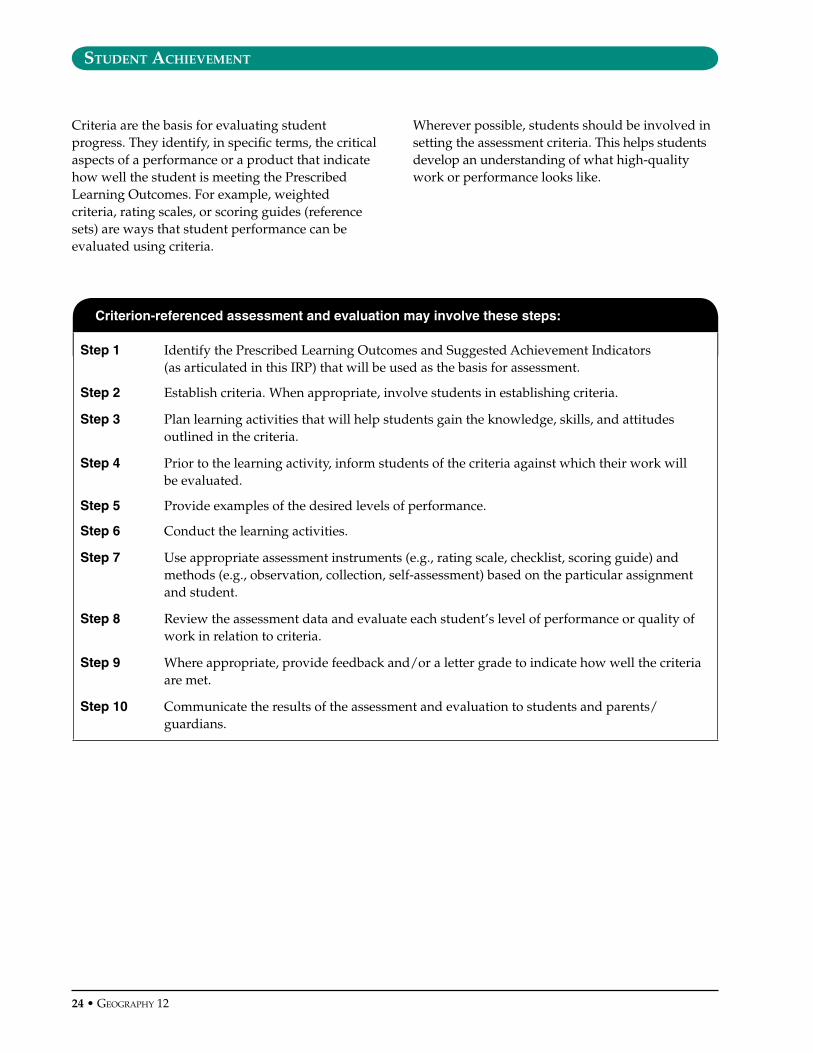
Criteria are the basis for evaluating student progress. They identify, in specific terms, the critical aspects of a performance or a product that indicate how well the student is meeting the Prescribed Learning Outcomes. For example, weighted criteria, rating scales, or scoring guides (reference sets) are ways that student performance can be evaluated using criteria.
Wherever possible, students should be involved in setting the assessment criteria. This helps students develop an understanding of what high-quality work or performance looks like.
Criterion-referenced assessment and evaluation may involve these steps:
Step 1 Identify the Prescribed Learning Outcomes and Suggested Achievement Indicators (as articulated in this IRP) that will be used as the basis for assessment.
Step 2 Establish criteria. When appropriate, involve students in establishing criteria.
Step 3 Plan learning activities that will help students gain the knowledge, skills, and attitudes outlined in the criteria.
Step 4 Prior to the learning activity, inform students of the criteria against which their work will be evaluated.
Step 5 Provide examples of the desired levels of performance.
Step 6 Conduct the learning activities.
Step 7 Use appropriate assessment instruments (e.g., rating scale, checklist, scoring guide) and methods (e.g., observation, collection, self-assessment) based on the particular assignment and student.
Step 8 Review the assessment data and evaluate each student’s level of performance or quality of work in relation to criteria.
Step 9 Where appropriate, provide feedback and/or a letter grade to indicate how well the criteria are met.
Step 10 Communicate the results of the assessment and evaluation to students and parents/guardians.

GeoGraphy 12 • 25
student achIevement • Key Elements
Key Elements: Themes and Skills
Estimated Time: �-10 hours
By the end of the course, students will understand five themes of geography and become proficient in the skills that geographers apply to their discipline.
Vocabulary
absolute location, atmosphere, biosphere, contour lines, cultural feature, GIS, GPS, gradient, hydrosphere, human and physical interaction, latitude, lithosphere, longitude, movement, region, relative location, remote sensing, scale, topographic, UTM grid reference
Knowledge
• themes of Geography: location, place, movement, regions, human and physical interaction• latitude and longitude• UTM grid reference• topographic features• characteristics that make a location unique • patterns of movement within living populations and physical systems of the Earth • types of regions• ways in which humans depend on, adapt to, and modify the environment• major interactions and characteristics of the four spheres (atmosphere, biosphere, hydrosphere,
lithosphere)• how various technologies are used by geographers• uses of GIS, GPS, and remote sensing (e.g., radar, infrared, satellite imaging)• the role of geography as a discipline
Skills and Attitudes
• communicate ideas, opinions, and arguments effectively, orally and in written form• identify main arguments, supporting evidence, and perspectives in a geography-related article or
illustration• provide supporting or refuting information and bias• describe how geographic concepts and technology affect individuals, society, and the environment• identify trends and relationships • use scale, area, distance, gradient, direction, grid references, topographic profiles, contour lines, map
symbols• identify cultural and natural features• interpret topographic maps• read and comprehend visual formats used in geography, including aerial photographs
26 • GeoGraphy 12
student achIevement • Suggested Achievement Indicators
Prescribed Learning Outcomes Suggested Achievement Indicators
It is expected that students will:
The following set of indicators may be used to assess student achievement for each corresponding Prescribed Learning Outcome.
Students who have fully met the Prescribed Learning Outcome are able to:
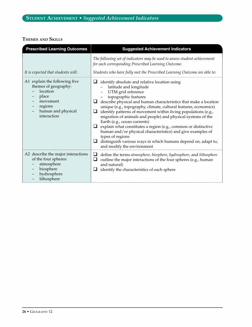
A1 explain the following five themes of geography:– location– place– movement– regions– human and physical
interaction
qidentify absolute and relative location using– latitude and longitude– UTM grid reference– topographic features
q describe physical and human characteristics that make a location unique (e.g., topography, climate, cultural features, economics)
q identify patterns of movement within living populations (e.g., migration of animals and people) and physical systems of the Earth (e.g., ocean currents)
q explain what constitutes a region (e.g., common or distinctive human and/or physical characteristics) and give examples of types of regions
q distinguish various ways in which humans depend on, adapt to, and modify the environment
A2 describe the major interactions of the four spheres:– atmosphere– biosphere– hydrosphere– lithosphere
qdefine the terms atmosphere, biosphere, hydrosphere, and lithosphereq outline the major interactions of the four spheres (e.g., human
and natural)q identify the characteristics of each sphere
themes and skIlls
GeoGraphy 12 • 2�
student achIevement • Suggested Achievement Indicators
Prescribed Learning Outcomes Suggested Achievement Indicators
A3 demonstrate geographic literacy through– analysis of geographic
data or information to assess reliability and identify trends and relationships
– interpretation of topographic maps and aerial and satellite images
– description of the role of geography as a discipline
qidentify the main arguments, supporting evidence, and perspectives in a geography-related article or image
q use given criteria for evaluating evidence and sources of information (e.g., identify supporting or refuting information and bias)
q identify trends and relationships (e.g., correlations, cause and effect) on the basis of image or data analysis
q interpret 1:50 000 topographic maps with reference to scale, area, distance, gradient, direction, grid references, topographic profiles, contour lines, map symbols, and cultural and natural features
q relate aerial photographs to corresponding topographic mapsq read and comprehend visual formats used in geography,
including– climate graphs, comparison graphs– statistical tables– aerial and satellite images– diagrams (e.g., cross-section)– flow charts– cartoons– articles
q explain how geographic concepts and technology affect individuals, society, and the environment
q give examples of possible applications of geographic knowledge, skills, and attitudes (e.g., possible careers)
A4 apply effective written, oral, and graphic communication skills to geography topics
q select a presentation form (e.g., written, oral, graphic) appropriate for the communication purpose
q communicate ideas, opinions, and arguments effectively, orally and in written form (e.g., clearly formulate and support a thesis)
q use geographic terms and concepts accurately in their observations, analyses, and conclusions
A5 describe the geographic applications of current information and imaging technologies
q identify various technologies used by geographersq give examples of how geographers use particular technologies,
including– GIS– GPS– remote sensing (e.g., radar, infrared, satellite imaging)

2� • GeoGraphy 12
student achIevement • Key Elements
Key Elements: Tectonic Processes
Estimated Time: 12-1� hours
By the end of the course, students will understand the features and processes associated with plate tectonics and the effects of volcanism and earthquakes.
Vocabulary
aftershock, anticline, asthenosphere, batholith, caldera, centrosphere, cinder cone, columnar jointing, composite cone, compression, continental plates, convection, convergent, divergent, dyke, epicentre, extrusive, faulting, focus, folding, graben, horst, igneous, intrusive, island arcs, laccolith, lahar, liquefaction, lithosphere, mass wasting, mesosphere, metamorphic, mid-ocean ridges, nuée ardente, oceanic plates, P-wave, pyroclastic flow, Richter scale, rift valleys, sedimentary, seismograph, shearing, shield volcano, sill, strike-slip, subduction, S-wave, syncline, tectonics, tension, transform, tremor, trenches, tsunami, volcanism
Knowledge, Skills, and Attitudes
• centrosphere, mesosphere, asthenosphere, and lithosphere• igneous, sedimentary, and metamorphic rocks• the rock cycle• processes associated with plate tectonics • types of plate boundaries • properties of oceanic and continental plates• volcanoes: types, features, origins, hazards, and effects• folding and faulting • hazards and effects of earthquakes
GeoGraphy 12 • 2�
student achIevement • Suggested Achievement Indicators
Prescribed Learning Outcomes Suggested Achievement Indicators
It is expected that students will:
The following set of indicators may be used to assess student achievement for each corresponding Prescribed Learning Outcome.
Students who have fully met the Prescribed Learning Outcome are able to:
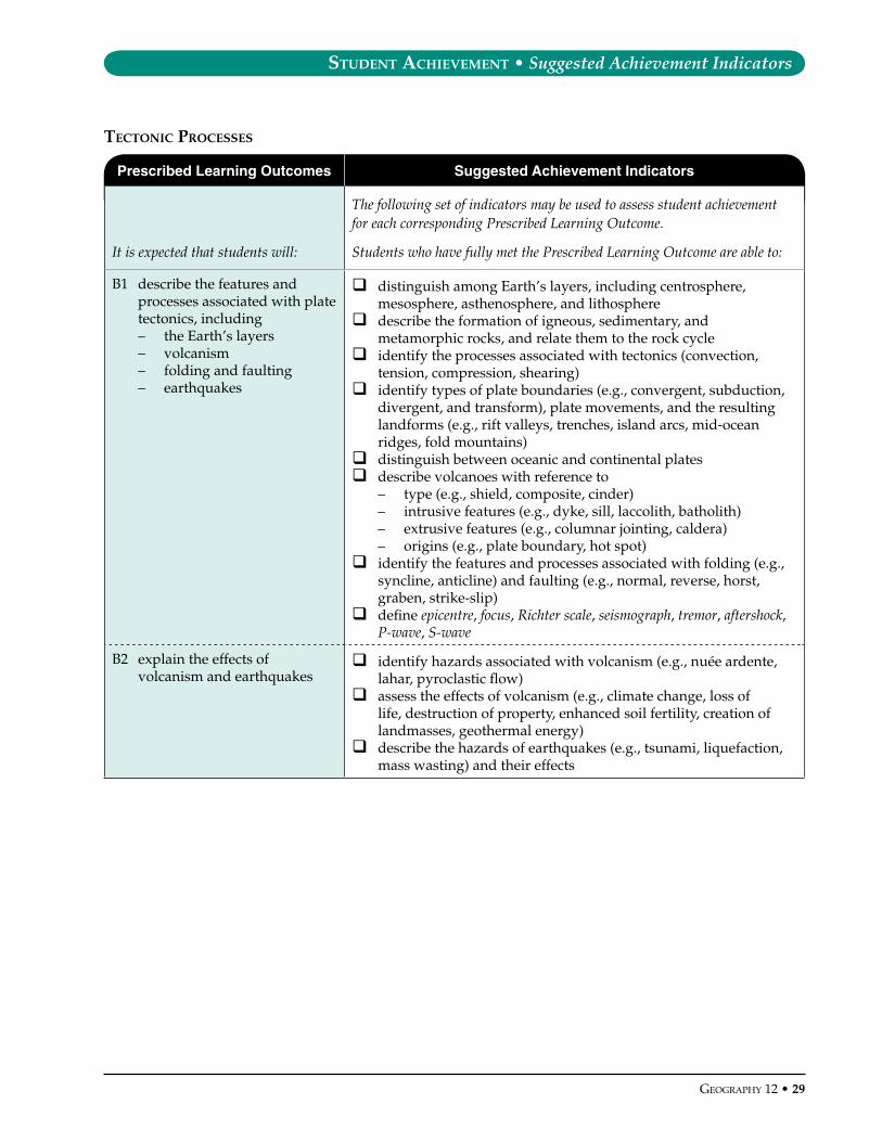
B1 describe the features and processes associated with plate tectonics, including– the Earth’s layers– volcanism– folding and faulting– earthquakes
qdistinguish among Earth’s layers, including centrosphere, mesosphere, asthenosphere, and lithosphere
q describe the formation of igneous, sedimentary, and metamorphic rocks, and relate them to the rock cycle
q identify the processes associated with tectonics (convection, tension, compression, shearing)
q identify types of plate boundaries (e.g., convergent, subduction, divergent, and transform), plate movements, and the resulting landforms (e.g., rift valleys, trenches, island arcs, mid-ocean ridges, fold mountains)
q distinguish between oceanic and continental platesq describe volcanoes with reference to
– type (e.g., shield, composite, cinder)– intrusive features (e.g., dyke, sill, laccolith, batholith) – extrusive features (e.g., columnar jointing, caldera)– origins (e.g., plate boundary, hot spot)
q identify the features and processes associated with folding (e.g., syncline, anticline) and faulting (e.g., normal, reverse, horst, graben, strike-slip)
q define epicentre, focus, Richter scale, seismograph, tremor, aftershock, P-wave, S-wave
B2 explain the effects of volcanism and earthquakes
q identify hazards associated with volcanism (e.g., nuée ardente, lahar, pyroclastic flow)
q assess the effects of volcanism (e.g., climate change, loss of life, destruction of property, enhanced soil fertility, creation of landmasses, geothermal energy)
q describe the hazards of earthquakes (e.g., tsunami, liquefaction, mass wasting) and their effects
tectonIc processes
�0 • GeoGraphy 12
student achIevement • Key Elements
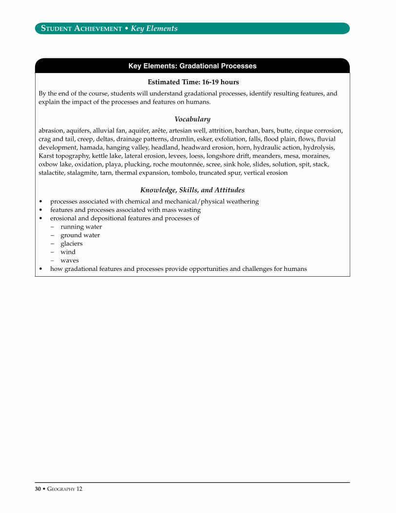
Key Elements: Gradational Processes
Estimated Time: 16-1� hours
By the end of the course, students will understand gradational processes, identify resulting features, and explain the impact of the processes and features on humans.
Vocabulary
abrasion, aquifers, alluvial fan, aquifer, arête, artesian well, attrition, barchan, bars, butte, cirque corrosion, crag and tail, creep, deltas, drainage patterns, drumlin, esker, exfoliation, falls, flood plain, flows, fluvial development, hamada, hanging valley, headland, headward erosion, horn, hydraulic action, hydrolysis, Karst topography, kettle lake, lateral erosion, levees, loess, longshore drift, meanders, mesa, moraines, oxbow lake, oxidation, playa, plucking, roche moutonnée, scree, sink hole, slides, solution, spit, stack, stalactite, stalagmite, tarn, thermal expansion, tombolo, truncated spur, vertical erosion
Knowledge, Skills, and Attitudes
• processes associated with chemical and mechanical/physical weathering • features and processes associated with mass wasting• erosional and depositional features and processes of
− running water− ground water− glaciers− wind− waves
• how gradational features and processes provide opportunities and challenges for humans

GeoGraphy 12 • �1
student achIevement • Suggested Achievement Indicators
Prescribed Learning Outcomes Suggested Achievement Indicators
It is expected that students will:
The following set of indicators may be used to assess student achievement for each corresponding Prescribed Learning Outcome.
Students who have fully met the Prescribed Learning Outcome are able to:
C1 describe the features and processes associated with weathering and mass wasting
qdescribe different processes associated with chemical and mechanical/physical weathering (e.g., hydrolysis, oxidation, exfoliation, thermal expansion, solution)
q describe features and processes associated with mass wasting (e.g., scree, slides, flows, falls, creep)
C2 describe the features and processes associated with– running water– ground water– glaciers– wind– waves
qdistinguish between weathering and erosionq identify the processes associated with
– running water (e.g., stages of fluvial development, methods of sediment transport, abrasion, hydraulic action, vertical erosion, lateral erosion, headward erosion)
– ground water (e.g., solution)– glaciation (e.g., plucking, abrasion)– wind (e.g., deflation, abrasion)– waves (e.g., longshore drift, abrasion, attrition, hydraulic
action, corrosion)q identify the erosional and depositional features associated with
– running water (e.g., meander, oxbow lake, levee, flood plain, delta, drainage pattern, alluvial fan, playa)
– ground water and Karst topography (e.g., sink hole, stalactite, stalagmite, artesian well, aquifer)
– glaciation (e.g., cirque, arête, horn, truncated spur, hanging valley, roche moutonnée, crag and tail, drumlin, kettle lake, moraine, tarn, esker)
– wind (e.g., barchan, loess, mesa, butte, hamada)– waves (e.g., headland, stack, spit, bar, tombolo)
C3 assess the effects of gradation on humans
q explain how gradational features and processes have provided both opportunities and challenges for humans (e.g., transportation, settlement, drinking water, recreational activity)
q explain the effects of gradational processes (e.g., landslides, avalanches, flooding, loss of land, soil erosion, subsidence)
GradatIonal processes

�2 • GeoGraphy 12
student achIevement • Key Elements
Key Elements: Weather and Climate
Estimated Time: 16-1� hours
By the end of the course, students will be able to explain the factors that create our weather, shape our major climatic regions, and affect human activities.
Vocabulary
absorption, advection fog, albedo, altitude, altostratus, anemometer, anticyclone, aspect, barometer, biosphere, chinook, cirrus, cold front, condensation, conduction, continentality, convection, Coriolis effect, cumulonimbus, cumulus, cyclones, dew point, doldrums, evaporation, frontal/cyclonic, hurricanes, hydrologic cycle, infiltration, insolation, jet stream, latitude, monsoons, nimbostratus, occluded, orographic, radiation fog, rainshadow, tornadoes, transpiration, warm front
Knowledge, Skills, and Attitudes
• atmospheric characteristics and processes: pressure, temperature, heating, composition• the hydrologic cycle • significance of cloud types• types of precipitation • characteristics of North American air masses • causes of air movement and global wind and pressure systems • radiation and advection fog • types of local weather phenomena • conditions that create extreme weather • climate controls and conditions• characteristics of the world’s climate regions:
– equatorial– tropical wet/dry– Mediterranean– desert– continental interior– humid continental (including humid sub-tropical)– west coast marine– sub-arctic– tundra
• causes of ozone depletion, global climate change, and acid rain, and possible responses• meteorological instruments • station model data • weather maps
GeoGraphy 12 • ��
student achIevement • Suggested Achievement Indicators
Prescribed Learning Outcomes Suggested Achievement Indicators
It is expected that students will:
The following set of indicators may be used to assess student achievement for each corresponding Prescribed Learning Outcome.
Students who have fully met the Prescribed Learning Outcome are able to:
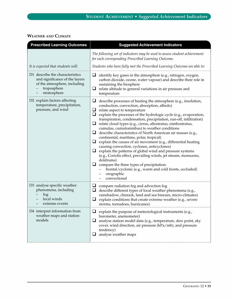
D1 describe the characteristics and significance of the layers of the atmosphere, including– troposphere– stratosphere
qidentify key gases in the atmosphere (e.g., nitrogen, oxygen, carbon dioxide, ozone, water vapour) and describe their role in sustaining the biosphere
q relate altitude to general variations in air pressure and temperature
D2 explain factors affecting temperature, precipitation, pressure, and wind
qdescribe processes of heating the atmosphere (e.g., insolation, conduction, convection, absorption, albedo)
q relate aspect to temperatureq explain the processes of the hydrologic cycle (e.g., evaporation,
transpiration, condensation, precipitation, run-off, infiltration)q relate cloud types (e.g., cirrus, altostratus, nimbostratus,
cumulus, cumulonimbus) to weather conditionsq describe characteristics of North American air masses (e.g.,
continental, maritime, polar, tropical)q explain the causes of air movement (e.g., differential heating
causing convection, cyclones, anticyclones) q explain the patterns of global wind and pressure systems
(e.g., Coriolis effect, prevailing winds, jet stream, monsoons, doldrums)
q compare the three types of precipitation: – frontal/cyclonic (e.g., warm and cold fronts, occluded)– orographic – convectional
D3 analyse specific weather phenomena, including– fog– local winds– extreme events
q compare radiation fog and advection fogq describe different types of local weather phenomena (e.g.,
rainshadow, chinook, land and sea breezes, micro-climates)q explain conditions that create extreme weather (e.g., severe
storms, tornadoes, hurricanes)
D4 interpret information from weather maps and station models
q explain the purpose of meteorological instruments (e.g., barometer, anemometer)
q analyse station model data (e.g., temperature, dew point, sky cover, wind direction, air pressure (kPa/mb), and pressure tendency)
q analyse weather maps
weather and clImate
�� • GeoGraphy 12
student achIevement • Suggested Achievement Indicators
Prescribed Learning Outcomes Suggested Achievement Indicators
D5 describe the characteristics of the world’s climate regions, including– equatorial– tropical wet/dry– Mediterranean– desert– continental interior– humid continental
(including humid sub-tropical)
– west coast marine– sub-arctic– tundra
q distinguish between weather and climateq describe the influence of climate controls, including
– latitude– mountain barriers– altitude– continentality (distance from major bodies of water)– pressure systems– ocean currents– prevailing winds
D6 explain how climate affects human activity
q describe the impact of climatic conditions (e.g., drought, freezing) on human activity (e.g., agriculture, energy generation, movement, settlement)
D7 analyse interactions between human activity and the atmosphere, with reference to– global climate change– ozone depletion– acid precipitation
q give examples of how human activity affects the atmosphere (e.g., types of atmospheric pollution)
q explain causes and possible effects of global climate change, ozone depletion, and acid precipitation
q describe possible responses to global climate change, ozone depletion, and acid precipitation

GeoGraphy 12 • �5
student achIevement • Key Elements
Key Elements: Biomes
Estimated Time: 12-1� hours
By the end of the course, students will be able to identify characteristics of the world’s major biomes with reference to climate, soil, vegetation, and human activity.
Vocabulary
biomes, buttress roots, capillary action, chernozem, deforestation, desertification, dormancy, epiphytes, fauna, flora, humus, hydrophytes, laterite, leaching, parent material, podzol, schlerophyll, sierozem, soil degradation, translocation, xerophytes
Knowledge, Skills, and Attitudes
• significance of limiting factors for biomes • characteristics of Earth’s major biomes:
– tropical rainforest– tropical grasslands/savanna– Mediterranean/schlerophyll– desert– temperate grasslands/prairie/steppe– deciduous/mixed forest– temperate rainforest– coniferous forest/boreal/taiga– tundra
• characteristics of soil and soil-forming features and processes • causes and effects of and possible responses to
– deforestation– desertification– soil degradation– species depletion
• impacts of human activity on flora and fauna, and possible responses• ways in which biomes provide opportunities for and set limitations on human activity
�6 • GeoGraphy 12
student achIevement • Suggested Achievement Indicators
Prescribed Learning Outcomes Suggested Achievement Indicators
It is expected that students will:
The following set of indicators may be used to assess student achievement for each corresponding Prescribed Learning Outcome.
Students who have fully met the Prescribed Learning Outcome are able to:
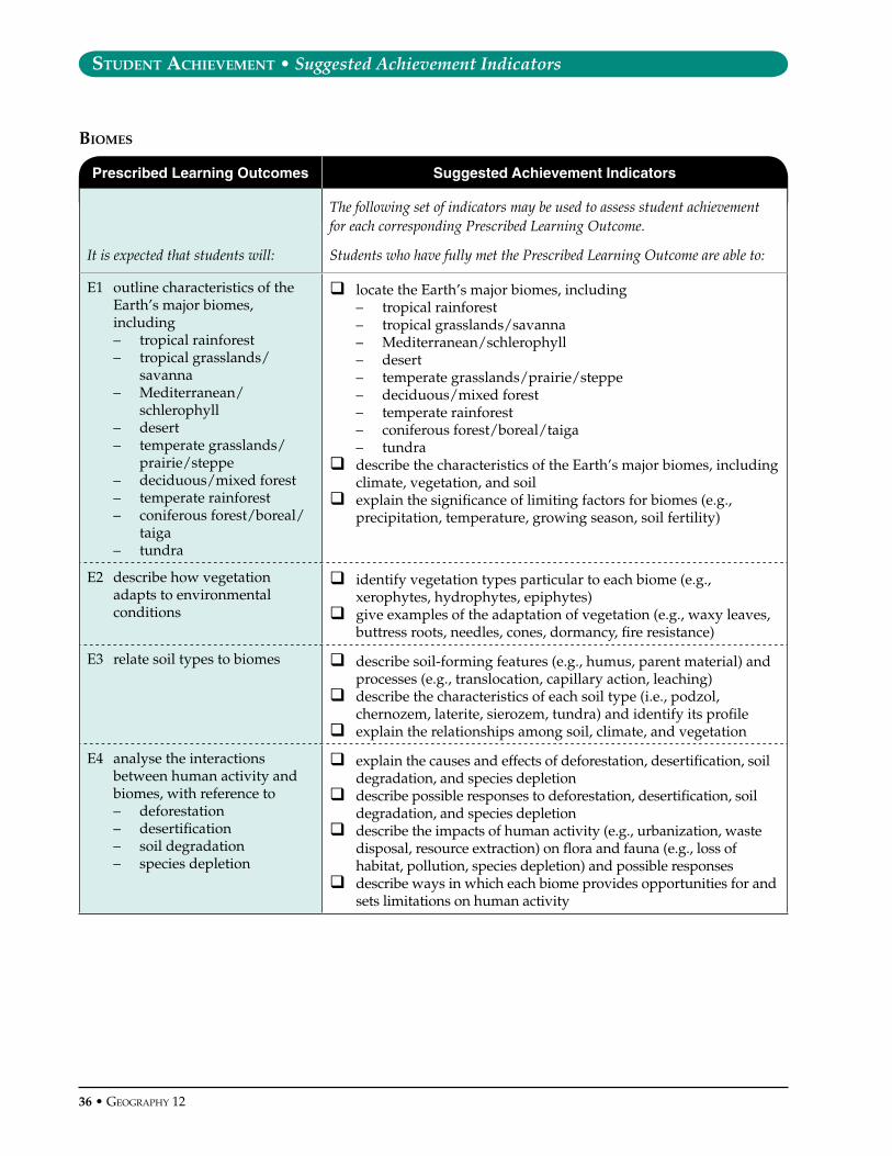
E1 outline characteristics of the Earth’s major biomes, including– tropical rainforest– tropical grasslands/
savanna– Mediterranean/
schlerophyll– desert– temperate grasslands/
prairie/steppe– deciduous/mixed forest– temperate rainforest– coniferous forest/boreal/
taiga– tundra
qlocate the Earth’s major biomes, including– tropical rainforest– tropical grasslands/savanna– Mediterranean/schlerophyll– desert– temperate grasslands/prairie/steppe– deciduous/mixed forest– temperate rainforest– coniferous forest/boreal/taiga– tundra
q describe the characteristics of the Earth’s major biomes, including climate, vegetation, and soil
q explain the significance of limiting factors for biomes (e.g., precipitation, temperature, growing season, soil fertility)
E2 describe how vegetation adapts to environmental conditions
qidentify vegetation types particular to each biome (e.g., xerophytes, hydrophytes, epiphytes)
q give examples of the adaptation of vegetation (e.g., waxy leaves, buttress roots, needles, cones, dormancy, fire resistance)
E3 relate soil types to biomes q describe soil-forming features (e.g., humus, parent material) and processes (e.g., translocation, capillary action, leaching)
q describe the characteristics of each soil type (i.e., podzol, chernozem, laterite, sierozem, tundra) and identify its profile
q explain the relationships among soil, climate, and vegetation
E4 analyse the interactions between human activity and biomes, with reference to– deforestation– desertification– soil degradation– species depletion
q explain the causes and effects of deforestation, desertification, soil degradation, and species depletion
q describe possible responses to deforestation, desertification, soil degradation, and species depletion
q describe the impacts of human activity (e.g., urbanization, waste disposal, resource extraction) on flora and fauna (e.g., loss of habitat, pollution, species depletion) and possible responses
q describe ways in which each biome provides opportunities for and sets limitations on human activity
bIomes
GeoGraphy 12 • ��
student achIevement • Key Elements
Key Elements: Resources and Environmental Sustainability
Estimated Time: 16-1� hours
By the end of the course, students will be able to explain possible consequences of resource management decisions and assess some of the ways that humans use various key resources.
Vocabulary
aquaculture, clearcutting, enhancement, geothermal, monoculture, non-renewable resources, renewable resources, shaft mining, silviculture, strip mining, sustainability
Knowledge, Skills, and Attitudes
• resource sustainability• possible socio-cultural, economic, and political consequences of resource-management solutions • different points of view related to resource management and use• benefits and drawbacks of practices associated with
– energy production and use – forestry – fishing – mining– agriculture – waste disposal – water use

�� • GeoGraphy 12
student achIevement • Suggested Achievement Indicators
Prescribed Learning Outcomes Suggested Achievement Indicators
It is expected that students will:
The following set of indicators may be used to assess student achievement for each corresponding Prescribed Learning Outcome.
Students who have fully met the Prescribed Learning Outcome are able to:
F1 assess the various considerations involved in resource management, including– sustainability– availability– social/cultural
consequences– economic consequences– political consequences
qdefine and give examples of renewable and non-renewable resourcesq define sustainabilityq identify and debate different points of view related to resource
management and use, considering assumptions, priorities, data availability/interpretation, and ethics of resource use
q analyse factors that make proposed resource-management decisions challenging to implement (e.g., social/cultural, economic, political consequences)
F2 assess the environmental impact of human activities, including– energy production and use– forestry– fishing– mining– agriculture– waste disposal– water use
qdescribe the benefits and drawbacks of practices associated with– energy production (e.g., fossil fuels, hydroelectricity, wind,
nuclear, solar, geothermal) and use (e.g., manufacturing, transportation)
– forestry (e.g., clearcutting, selective logging, silviculture)– fishing (e.g., aquaculture, enhancement, over-fishing)– mining (e.g., strip mining, shaft mining)– agriculture (e.g., monoculture, soil-conservation strategies)– waste disposal (e.g., recycling, incineration, landfill)– water use (e.g., domestic, agricultural, and industrial use;
exports)
resources and envIronmental sustaInabIlIty
classroom assessment model
Geography 12


classroom assessment model
GeoGraphy 12 • �1
The Classroom Assessment Model outlines a series of assessment units for Geography 12. These units have been structured according
to the curriculum organizers for this course:• Themes and Skills• Tectonic Processes• Gradational Processes• Weather and Climate• Biomes• Resources and Environmental Sustainability
understandInG the classroom assessment model This organization is not intended to prescribe a particular means of course delivery. Teachers are encouraged to reorder the learning outcomes and to adapt, modify, combine, and organize the units to meet the needs of their students, to respond to local requirements, and to incorporate relevant recommended learning resources as applicable. (See the Learning Resources section later in this IRP for information about the recommended learning resources for this course.)
Classroom Assessment and Evaluation in Geography 12Teachers should consider using a variety of assessment techniques to assess students’ abilities to meet the Prescribed Learning Outcomes. In addition to grading of students’ written output (e.g., essays, tests), tools and techniques for assessment in Geography 12 can include• teacher assessment tools such as observation
checklists, rating scales, and scoring guides• self-assessment tools such as checklists, rating
scales, and scoring guides• peer assessment tools such as checklists, rating
scales, and scoring guides• journals or learning logs• video (to record and critique student
demonstration)• written tests, oral tests (true/false, multiple
choice, short answer)• worksheets• portfolios• student-teacher conferences
Assessment in Geography 12 can also occur while students are engaged in, and based on the product of, activities such as• case studies and simulations• group and class discussions• brainstorms, clusters, webs• research projects• role plays• charts and graphs• posters, collages, models, web sites• oral and multimedia presentations• peer teaching
For more information about student assessment, refer to the section on Student Achievement.
contents of the model
Assessment Overview TableThe Assessment Overview Table provides teachers with suggestions and guidelines for assessment of each aspect of the curriculum. This table identifies the domains of learning and cognitive levels of the learning outcomes, along with a listing of suggested assessment activities and a suggested weight for grading for each curriculum organizer.
Prescribed Learning Outcomes and Suggested Achievement IndicatorsEach set of Prescribed Learning Outcomes identifies the content standards for that unit. The corresponding achievement indicators provide additional information about the expected level or degree of student performance and can be used as the basis for assessment.
Suggested Assessment ActivitiesAssessment activities have been included for each set of Prescribed Learning Outcomes and corresponding achievement indicators. Each assessment activity consists of two parts:• Planning for Assessment – outlines the
background information to explain the classroom context, opportunities for students to gain and practise learning, and suggestions for preparing the students for assessment
classroom assessment model
�2 • GeoGraphy 12
• Assessment Strategies – describes the assessment task, the method of gathering assessment information, and the assessment criteria as defined by the learning outcomes and achievement indicators
These activities are suggestions only, designed to provide guidance for teachers in planning instruction and assessment to meet the Prescribed Learning Outcomes.
Assessment InstrumentsSample assessment instruments have been included at the end of the Classroom Assessment Model, and are provided to help teachers determine the extent to which students are meeting the Prescribed Learning Outcomes. These instruments contain criteria specifically keyed to one or more of the suggested assessment activities contained in the unit.
Classroom assessment Units
Geography 12

Classroom assessment model
44 • GeoGraphy 12
GeoGraphy 12: assessment overview table
The purpose of this table is to provide teachers with suggestions and guidelines for formative and summative classroom-based assessment and grading.
Curriculum Organizers
Suggested Assessment Activities
Suggested Weight for Grading
Suggested Teaching
Time
Number of Outcomes
Number of Outcomes
by Domain*
K U&A HMP
themes and skills
• field studies• data analysis• group work• research, presentations• image analysis • written test• guest speakers
15% 10% 3 1 1 1
teCtoniC proCesses
• image creation and analysis
• surveys• written tests• research, presentations
15% 15% 2 1 1 0
Gradational proCesses
• field studies• image/model creation
and analysis • research, presentations• written tests• data compilation and
analysis• summaries
20% 20% 3 2 0 1
weather and Climate
• field studies• image creation • case studies• simulations• written tests• data analysis • research, presentations• summaries
15% 20% 7 2 4 1
biomes
• image creation and analysis
• research, presentations• labs• written tests• data compilation and
analysis • summaries
15% 15% 4 2 1 1
resourCes and environmental sustainability
• simulations• image creation and
analysis • debates• research, presentations
20% 20% 2 0 0 2
totals 100% 100% 21 8 7 6
* The following abbreviations are used to represent the three levels within the cognitive domain: K = Knowledge; U&A = Understanding and Application; HMP = Higher Mental Processes.
classroom assessment model
GeoGraphy 12 • �5
prescrIbed learnInG outcomes
It is expected that students will:A1 explain the following five themes of geography:
– location– place– movement– regions– human and physical interaction
Planning for Assessment Assessment Strategies
• Place the students into groups of four. Write the two terms absolute location and relative location on the board. Ask the students to each write out in their notebooks what they think each term means. After a minute or two, they are to confer with their partners and develop a consensus within the group as to what they think the terms mean. Ask various groups to present their definitions. Through a class discussion, develop a clear and concise meaning of these two terms.
Assign each group a major settlement from a different region of Canada and tell each group to search through their classroom atlas to identify examples of how each term could be explained through reference to that specific community (e.g., the absolute location of our settlement is _____; five relative locators for our settlement are _____).
• Have each group present their ideas and information on a poster (each poster can be displayed in the classroom). Mark each poster according to a four-point or five-point rubric using criteria such as the following:− title− accuracy of information− relevance of information− clarity of information− visual impact
themes and skIlls
continued next page
classroom assessment model
�6 • GeoGraphy 12
Planning for Assessment Assessment Strategies
• Take the class on a walking field trip of the neighbourhood in which their school is located. Prepare in advance a data collection sheet for students to record observations about key physical and human characteristics of their neighbourhood. Physical characteristics can include topography, vegetation, rock formations, rivers, streams, drainage patterns, wildlife, etc. Human characteristics can include architecture, services, patterns of residential, commercial, or industrial development, communication and transportation infrastructure, etc. Leave space on the data collection sheet for students to explore their own categories of physical and human characteristics. When the students return from the field trip, as a class generate a master data sheet of all the physical and human characteristics that they have observed. From this master data sheet, have each student create a short brochure with a catchy title. In this composition, each student would explain, using observable characteristics, what makes their neighbourhood a distinct place.
As a follow-up, have students (again as a field study) visit other neighbourhoods (i.e., each group visit a different neighbourhood) and complete a second data collection sheet. Each group could then report on the characteristics that make this second neighbourhood different from (and similar to) their home neighbourhood.
• While conducting the tour, observe students’ participation, considering− the number of observations recorded− the accuracy of classifications− the extent to which pertinent new categories
are identified
Assess each brochure using a standard four-point or five-point scale for formal written assignments. Consider how well students− develop a succinct definition of the concept
place− support their claims about their
neighbourhood with appropriate evidence (i.e., characteristics recorded)
− introduce comparative information (e.g., about other neighbourhoods they are familiar with), as appropriate
− present their findings and arguments in writing (e.g., logical sequence, appropriate introduction and conclusion)
− add visual appeal
Themes and Skills (continued)
continued next page
classroom assessment model
GeoGraphy 12 • ��
Planning for Assessment Assessment Strategies
• On the basis of student input, compile a list of the differing ethnic or national backgrounds of class members (this may require going back multiple generations in some cases). On a political/physical wall map of the world, have each student use a piece of string to draw a connection between their home community, and the place of their (or their ancestor’s) homeland. Mark each homeland spot with a pin and a name tag of the nation (e.g., Russia) and/or region (e.g., Siberia). Have each student research their ancestral homeland with a view to answering the question, “What are the historical, political, economic, religious, cultural, (and other?) reasons for the movement that led to me being here now?” Research may be oral (e.g., asking family members) or print/electronic (e.g., obtaining information from cultural centres). Each student will be responsible for creating a short oral presentation demonstrating how their present family is connected with other regions, cultures, and people in the world – both present and past.
• Assess the oral presentation using criteria that highlight the following attributes: organization, content, clarity, effectiveness, and/or impact.
Themes and Skills (continued)
continued next page
classroom assessment model
�� • GeoGraphy 12
Themes and Skills (continued)
Planning for Assessment Assessment Strategies
• Have students trace the evolution of political regions in North America by working in pairs. Provide each pair of students with a large outline map of North America showing key river and lake systems for orientation. Assign each pair one of the following dates: 1500; 1600; 1690; 1713; 1763; 1774; 1784; 1825; 1866; 1867; 1873; 1905; 1912; 1949; 1997. By consulting various atlases, each pair needs to show on their map the political regions that existed at the time (i.e., regions of Canada from 1867 onwards; regions of British North America 1866–1760; regions of New France 1760–1534; regions of native societies prior to 1500). Each group should show its information using standard conventions of mapping (e.g., title; R/f scale; latitude and longitude grid; north direction symbol; legend features; appropriate labelling, border). Once all maps are completed, post them around the classroom in chronological order. Hand out a contemporary political map of Canada, then conduct a discussion around questions such as − Which regions (from each map) still exist as
a political boundary today?− Why have the regions changed over time
(military, economic, religious, diplomatic, cultural reasons)?
− Can you speculate on what might be a political boundary change in the future?
• Assess each pair’s map work with reference to standard mapping conventions, such as− title: accurate and informative− scale: correct calculation of R/f− latitude and longitude: correct location
placed− north direction symbol: placed along a
meridian of longitude− legend box: appropriate use of colours,
symbols, points, etc.− labelling: correct style use for political
labelling− border: neat and accurate
As well, ask each student to self-assess their understanding of the concept of region as a basic unit of geographic study, and of the factors that help explain how regions change over time.
• Divide the class into groups of five. Have each group prepare a poster showing how their home city, town, hamlet, etc. connects to the larger world. Assign each group a category of interactions (e.g., economic, political, cultural, sports, scientific, natural hazards, population migration patterns, educational, weather patterns). Provide students with class time to research their particular interaction (using both print and electronic information sources) and to put the information together in a poster format. Posters should be displayed, and each group should be prepared to make an oral presentation to the class of its findings.
• Mark each poster with reference to criteria such as − appropriateness of title− accuracy of information− relevance of information− clarity of information− impact of information− artistry/neatness of presentation

classroom assessment model
GeoGraphy 12 • ��
prescrIbed learnInG outcomes
It is expected that students will:A2 describe the major interactions of the four spheres:
– atmosphere– biosphere– hydrosphere– lithosphere
Planning for Assessment Assessment Strategies
• Have students complete readings or use other resources to acquire basic definitions of the four spheres and information about the key characteristics of each. Divide the class into groups (e.g., three students per group) and ask them to brainstorm possible interactions that could occur among the spheres (e.g., pollution in the atmosphere can cause acid precipitation within the hydrosphere, which can in turn affect the lithosphere and biosphere; there are many examples of ways in which the activities of humans – part of the biosphere – are affected by the other spheres and in turn affect the rest of the biosphere as well as the other three spheres). Have one student in the group act as a recorder of the ideas. Following some opportunity for discussion and refinement within the groups, have the groups post and share their ideas with the whole class. This will help the class to become aware of the variety of interactions among the spheres.
• Observe students to ensure they are aware of the definitions of the four spheres, and the range of the spheres’ possible interactions. As students present the results of their brainstorming, provide clarifications and correct misconceptions as needed. Summative assessment of the definitions can be carried out at any point using a conventional written test.
• Have students find and present a remote sensing image that gives evidence of an interaction. A good example of this would be NASA’s Terra Earth Observing System (EOS) AM-1. Each student would be responsible for a single sheet presentation that includes a copy of the remote sensing image and a brief description of the interaction that is occurring between two or more spheres. These single-sheet presentations could be posted around the room for other students to view.
• Assess students’ choice of images with reference to criteria such as the following:− completion− relevance/appropriateness of image− clarity of image
Assess the accompanying written portion with reference to criteria such as the following:− correct identification of the spheres involved − correct description of the interaction taking
place− clarity of expression
themes and skIlls

classroom assessment model
50 • GeoGraphy 12
prescrIbed learnInG outcomes
It is expected that students will:A3 demonstrate geographic literacy through
– analysis of geographic data or information to assess reliability and identify trends and relationships
– interpretation of topographic maps and aerial and satellite images– description of the role of geography as a discipline
Planning for Assessment Assessment Strategies
• Discuss the components of geographic literacy and ensure students understand that these will form a basis for the assessment criteria for term assignments such as research essays or projects. Discuss the characteristics of geographic literacy skills such as − research skills− comprehension and analysis of sources− grasp of central course concepts (e.g.,
interdependence, sustainability)
• Criteria for assessing research skills might include looking at the extent to which students− examine a wide range of print, non-print
and electronic sources− identify a range of possible sources of
information− assess sources for relevance, currency,
reliability− cite sources scrupulously and accurately
Criteria for assessing comprehension and analysis of sources might include looking at the extent to which students− clearly identify the main points in any
geography related articles or illustrations that they are using and recognize point of view (e.g., by comparing sources)
− interpret technical terms or conceptual language correctly
− articulate agreement or disagreement with positions presented in sources, identifying bias where evident
Students could also be assessed on their ability to relate their research findings (project work) to what has been covered in class with respect to major course concepts (e.g., renewable resources, limiting factors for biomes, weathering, the themes of geography, the four spheres).
themes and skIlls
continued next page
classroom assessment model
GeoGraphy 12 • 51
Themes and Skills (continued)
Planning for Assessment Assessment Strategies
• Use mapping resources gathered over time (e.g., a collection of topographical map extracts, relevant aerial photographs, and complementary satellite images) to teach− basic calculation of area− understanding concepts of large scale vs.
small scale− the three types of scale (with focus on the
Representative Fraction Scale)− direction (true; grid; magnetic north)− grid references, latitude, and longitude− contour lines, contour intervals,
topographic profile, and gradients map symbols (using the legend that appears on the back of any extract)
By using extracts that show a local environment, the students will be able to relate a real-life experience of that environment to what the map extract is showing them.
If an aerial photograph and topographic extract of the same landscape can be obtained, basic aerial photography skills can be introduced as well (i.e., orientation of the aerial photograph with the topographic map extract; comparison of scales between the map and the photograph; interpretation of shape, size, colour or tone, and texture; identification of cultural and natural features; modification of the landscape over time).
At a more sophisticated level, use comparison of topographic map extracts and aerial photographs (and if possible, satellite imagery) to examine geomorphologic features in the landscape (e.g., alpine and continental glaciation, stages of river development and delta formation, aeolian features such as sand dunes, underground water features such as those found in a Karst landscape, coastal features such as those produced by longshore drift and wave action, extrusive and intrusive volcanic features, landscape features produced by tectonic folding or faulting, and landscapes produced by weathering and mass wasting). Often, a good geographic atlas simplifies this task by bringing the three types of geographic image (topographic maps, aerial photographs, satellite imagery) together in one resource.
• Assesses student work with maps, photographs, and images according to the type of images used. For example, topographic mapping skills that could be assessed include− reading titles− identifying and applying scales− applying the UTM grid to identify location
and place− identifying contour intervals and
interpreting contour lines (including spot heights)
− identifying and understanding symbols (including colours)
− constructing topographic profiles− calculating gradients
Aerial photographic skills assessed could include− orientating the photograph (or aligning it to
a topographic extract)− identifying cardinal directions− comparing scales with topographic extracts− identifying both natural and human-made
features− identifying land use features by interpreting
the use of tone, texture, and shadows (colour)− deducing information about usage from the
features that one has identified
Satellite imagery skills include− ascertaining the position, size, shape, and
distribution of geographic phenomena in the landscape
− interpreting data produced by false colouring (highlighting various landscape phenomena)
− identifying changes that have taken place in a landscape over time
continued next page
classroom assessment model
52 • GeoGraphy 12
Planning for Assessment Assessment Strategies
• Invite a geography professor or professional with a background or professional interest in geography (e.g., land-use planner, environmental advocate) to your class. Alternatively, take your class on a field trip to the geography department of a local college or university. Focus presentations or discussion on the possible applications of geographic knowledge, skills, and attitudes. For example, the guest speaker may talk about possible careers in the geography field, or how, by developing a geographic framework, the students can make good decisions about geographic issues that are affecting them and their community (i.e., local to global). Or simply, why the study and appreciation of geography is an enjoyable pursuit.
• During the presentation, students should be expected to listen carefully and take appropriate notes (perhaps the guest speaker may have talking points prepared in advance) with a view to developing a short composition on the topic of The Relevance of Geography in My Life. Assess this with reference to considerations such as− the establishment of a thesis− support of the thesis through relevant
information and persuasive arguments− insightful conclusions− effectiveness of communication
Themes and Skills (continued)

classroom assessment model
GeoGraphy 12 • 5�
prescrIbed learnInG outcomes
It is expected that students will:A4 apply effective written, oral, and graphic communication skills to geography topics
Planning for Assessment Assessment Strategies
• While having students complete a term assignment (e.g., research essay or project), discuss expectations with respect to communication and presentation of information and ideas. Ensure students understand that these will form part of the basis for the assessment criteria. Assessment could be focussed on categories such as − effective selection and use of presentation
forms (e.g., essay, report, poster, slide show with commentary, video)
− articulation and defence of a thesis− correct and appropriate use of language,
especially geographic terminology
• Criteria for assessing use of presentation forms might include looking at the extent to which students− clarify their purpose and assumptions− achieve an appropriate balance of images,
data charts, and prose text, given their intended purpose
− include an appropriate introduction and conclusion
− remain on-topic− express themselves clearly, avoiding
ambiguity and awkward constructions− provide an appropriate level of detail and
adhere to an appropriate length − use technical terms or conceptual language
correctly, with awareness of audience
Criteria for assessing presentation might include looking at the extent to which students control volume, pacing, and integration of text with imagery to make their presentations clear and appealing to their audience (peers). Criteria for assessing defence of a thesis might include looking at the extent to which students− clearly articulate a thesis− distinguish between their own opinions and
those put forward in the sources they are using
− develop logical, coherent arguments− relate supporting evidence to their main
arguments
themes and skIlls
classroom assessment model
5� • GeoGraphy 12
prescrIbed learnInG outcomes
It is expected that students will:A5 describe the geographic applications of current information and imaging technologies
Planning for Assessment Assessment Strategies
• Invite a geography professor or professional with a background or professional interest in geography (e.g., land-use planner, environmental advocate) to your class. Alternatively, take your class on a field trip to the geography department of a local college or university. Focus presentations or discussion on the use of tools and techniques in geography – how instruments work, why they are used, problems associated with using them, changes in technology that have recently happened or are being implemented.
• During the presentation, students should be expected to listen carefully and take appropriate notes (perhaps the guest speaker may have talking points prepared in advance) with a view to developing a short composition on one or more of the technologies or methods discussed. Have each student develop a methodology-related or technology-related focus question that they will try to find an answer to. Assess the questions that students ask during the presentation (for relevance, insightfulness) and afterward assess their ability to variously− summarize what they have learned
about the use of technology in geography accurately and concisely
− provide a reasonably accurate explanation of how the technology works
− provide specific examples of findings obtained using the technology
− relate findings obtained with the help of technology to a significant insight or significant conclusion drawn
− assess the significance of the technology for the practice of geography
• As an alternative, have students research a particular technology used in the practice of geography (e.g., how it works, why it is significant, what it has allowed geographers to achieve).
• Assess the extent to which students have provided− the identification of a significant technology− an adequate explanation of how it works
(i.e., general principles)− examples of its application− an assessment of its significance
themes and skIlls
classroom assessment model
GeoGraphy 12 • 55
prescrIbed learnInG outcomes
It is expected that students will:B1 describe the features and processes associated with plate tectonics, including
– the Earth’s layers– volcanism– folding and faulting– earthquakes
Planning for Assessment Assessment Strategies
• Provide students with an up-to-date cross-sectional diagram of Earth’s compositional layers, and discuss it with the class.
• This can be assessed using a blank diagram that students are expected to fill in with the correct labels.
• Using rock samples, point out to students the features of each sample (e.g., colour, crystal size, layers) and have them identify the differences between the main rock types. Then, explain the rock cycle to students.
• Give students a blank chart showing the rock cycle. Ask them to label the chart with the appropriate terms and processes.
• Using video resources, introduce students to − the theories of plate tectonics (including the
role of convection)− the three types of plate movement
(convergence, tension, and shearing)− the major boundary types− faulting and folding
As follow-up, have the class identify and map the major tectonic plates on a map you provide.
Have students research the major types of plate boundary. Then provide students with a world map, and have them add or identify major tectonic plates, boundaries, and boundary types, and sketch them. Have students pay particular attention to locations of earthquake focus, epicentre, and volcano development/mountain building.
• Ensure that student research includes references to subduction, convergent, divergent, and transform boundaries. Assess students’ maps and sketches by considering how well they − identify type of plate movement− identify type of volcanic activity− use basic map conventions (e.g., title, scale,
legend, direction)
• Use a matching quiz to verify that students are able to associate plate boundary types with processes and resultant landforms (e.g., continent to continent boundaries caused by converging plates; example: Himalayas).
tectonIc processes
continued next page
classroom assessment model
56 • GeoGraphy 12
Tectonic Processes (continued)
• Have students read resource materials to learn about the distinction between oceanic and continental plates (density).
• Provide a columnar chart showing different types of plate activity (divergent, convergent, transform, hot spot) and ask them to identify, for each type− plate type (oceanic vs. continental)− processes− resulting features− locations− impact on humans
• Outline, using available electronic or slide photos, the three basic types of volcanoes (cinder, shield, and composite). Have students research the size, shape, and composition of each type.
• Have students conduct peer assessments of each others’ completed charts, looking for accuracy and completeness.
• After providing basic information (e.g., on how earthquake epicentres are determined using P-waves and S-waves), have students research a particular earthquake or volcano (provide a list for students to choose from). Students will then give a brief summary of that event to the class, and place a red sticker on the classroom map to mark its location. At the end of the class presentations, the classroom map will make an excellent reference for students to know where these events take place. Use the class map to reinforce student understanding of the relationship between seismic/volcanic events and plate boundaries.
• Assess students’ presentations with reference to− the quality of research (number, variety, and
quality of resources used and correctly cited)− inclusion of information about causes, type
of volcano or earthquake, location, date of occurrence, current status, and impact on humans
• Divide the class into groups and provide each group with a landmark associated with volcanism (e.g., Old Faithful, Shiprock, Crater Lake, Devil’s Tower, Black Tusk, Giant’s Causeway). Have students create a presentation including what it is, how it was formed, how it has changed over time.
• Assess student presentations with respect to− clarity− thoroughness− accuracy− correct use of geographic terminology− creativity
• Use prepared models (commercial or improvised) and corresponding photographs to demonstrate folding and faulting.
• Have students maintain a personal glossary of terms including those related to tectonics.
• A terminology quiz (possibly including illustrations to be recognized) can be used to assess student understanding of terms such as syncline, anticline, normal, reverse, horst, graben, strike-slip epicentre, focus, Richter scale, seismograph, tremor, aftershock, P-wave, and S-wave.

classroom assessment model
GeoGraphy 12 • 5�
prescrIbed learnInG outcomes
It is expected that students will:B2 explain the effects of volcanism and earthquakes
Planning for Assessment Assessment Strategies
• Conduct a classroom discussion on hazards associated with earthquakes and volcanoes.
• Have students create a poster or other visual representation associated with volcanism or earthquakes. Assess the extent to which they include associated hazards, including nuée ardente, lahar, pyroclastic flow, tsunami, liquefaction, mass wasting.
• Describe the problems associated with earthquake prediction, and, using video, show students several examples of earthquake preparation.
• Have students in groups conduct an assessment of earthquake preparedness of the school (school grounds and classrooms) and present their work to the class. Assess the extent to which their presentations− are organized− are thorough− identify potential problems− include recommendations
• Brainstorm a list of possible effects of volcanoes and earthquakes on the physical environment, flora, fauna, and humans. As a class, discuss the problems and opportunities associated with the various items on the list. Have students classify the effects as physical, environmental, economic, political, and/or social/cultural.
• Referring to the brainstormed list, relate volcanoes and earthquakes to changes within the four spheres (atmosphere, biosphere, hydrosphere, lithosphere).
• Assess the extent to which students− include a wide range of effects− identify both problems and opportunities− classify with insight− identify important relationships (e.g.,
between environmental and economic consequences)
tectonIc processes
classroom assessment model
5� • GeoGraphy 12
prescrIbed learnInG outcomes
It is expected that students will:C1 describe the features and processes associated with weathering and mass wasting
Planning for Assessment Assessment Strategies
• Prepare a worksheet for students to define terms and gather information about the cycle of erosion, types of weathering, and factors that influence the amount of weathering. Terms might include− gradation, aggradation, degradation,
base level− weathering, transport, deposition− mechanical/physical weathering, ice
wedging, thermal expansion, exfoliation − chemical weathering, solution, hydrolysis,
oxidation − nature of bedrock, climate, slope and
drainage, human activity− worldwide distribution of dominant
mechanical/physical and chemical weathering
• Have students create a glossary of gradation terms to be maintained throughout the unit. Assess their glossaries, considering− completeness− accuracy of definitions− inclusion of diagrams as appropriate− organization of material (e.g., alphabetical)− inclusion of relevant examples
• Use visuals and direct instruction to introduce students to the main types of mass wasting.
• Have students record the information in a two-column chart according to speed of movement (slowest to fastest) and composition of flow (one column Rock/Ice/Debris and the other Soil). Include the following:− talus creep, slide, avalanche debris
avalanche, fall− soil creep, slump, solifluction, earth flow,
mud flow
GradatIonal processes
classroom assessment model
GeoGraphy 12 • 5�
prescrIbed learnInG outcomes
It is expected that students will:C2 describe the features and processes associated with
– running water– ground water– glaciers– wind– waves
Planning for Assessment Assessment Strategies
• Explain the difference between weathering (the breaking down of material due to mechanical or chemical processes) and erosion (the transport and deposition of weathered material by agents of erosion).
• Have students document weathering and erosion in progress (e.g., by producing photos, video clips, or descriptions). Assess their documentation, considering how well they− clearly show one or other process− correctly identify the process involved− include documentation of location, time
made, and other pertinent information
• Provide students with a simple line diagram of a river system. Have them label features such as the following:− source− mouth− confluence− interfluve− tributary− distributary− delta drainage basin/watershed, divide
• Supply students with topographic maps or aerial photos showing a region large enough to include all of the river features you wish to focus on. Have them each label on the map or photo the features (as per their work on the line diagram). Assess their work for correctness (accuracy). Discuss any common errors.
• Have students define and list examples of− the cycle of erosion (weathering, transport
and deposition)− processes of river erosion (corrasion/
abrasion, hydraulic action, attrition)− river bedload movement (solution,
suspension, saltation and traction)− the stages of a river (youth, maturity, old
age, rejuvenation)
• Have students update glossary of gradation terms.
• Provide students with two or three versions of each of the following types of data set:− descriptions of fluvial landforms− terms relating to processes of river erosion,
transportation, and deposition that are characteristic of a particular stage
− photographs, images, and topographic maps featuring a river
Have students match each given sample to one of the main stages of a river.
GradatIonal processes
continued next page
classroom assessment model
60 • GeoGraphy 12
Planning for Assessment Assessment Strategies
• Have students research and create a map of the world indicating areas of Karst topography and major cave sites.
• Provide students with a diagram of features created by groundwater (e.g., artesian well, spring, stalactites and stalagmites) and have them correctly label the features.
• Use a quiz or other test format to assess student understanding and retention of terminology and related processes.
• Have students define terms associated with aeolian processes (e.g., corrasion/abrasion, attrition, deflation).
• Use a quiz or other test format to assess student understanding and retention of terminology and related processes.
• Have students identify and define terms associated with coastal processes (e.g., corrasion/abrasion, corrosion, hydraulic action, attrition, longshore drift).
• Using topographic maps, charts and aerial photos, have students identify features of emergent coastlines and submergent coastlines.
• Use a quiz or other test format to assess student understanding and retention of terminology and related processes.
• Have students create a chart of opportunities and challenges associated with each type of coastline.
• Through the use of visuals, direct instruction, and a student worksheet introduce the following concepts and terms related to glaciation:− current global locations of ice (high
latitudes – polar ice caps; high altitudes – alpine glaciers)
− conditions required for snow accumulation and transformation to ice
− processes of glacial erosion (plucking and abrasion) and glacial movement
− landforms (erosional and depositional) resulting form alpine and continental glaciation
• Have students use the Internet to collect a photo gallery of glacial landforms. In chart format have students categorize them as − alpine vs. continental− erosional vs. depositional− deposition by ice vs. deposition by
meltwater (glaciofluvial) Assess the extent to which students can classify
all of the given features and the accuracy of their categorizations.
• Through direct instruction and use of maps and visuals explain the causes and locations of the major deserts of the earth:− high pressure – Sahara Desert− cold ocean currents – Atacama Desert− continentality – Gobi Desert− rain shadow – Mojave Desert
• Provide students with a list of desert landforms, and have them label desert landforms on a diagram.
• Use a quiz or other test format to assess student understanding and retention of terminology and related processes.
Gradational Processes (continued)

classroom assessment model
GeoGraphy 12 • 61
prescrIbed learnInG outcomes
It is expected that students will:C3 assess the effects of gradation on humans
Planning for Assessment Assessment Strategies
• Have students research river management issues associated with one of the following:− a hydroelectric dam (e.g., Three Gorges)− a river diversion project (e.g., Aral Sea,
NAWAPA, Garrison Diversion)− a recurring flooding problem (e.g., Red
River, Mississippi) Ask each student to summarize his or her
research in a concise one-page abstract on the instance/issue.
• Students should make class copies of their summaries to share with classmates. Use peer and teacher assessment to determine how well students have addressed each of the following in their summaries:− physical effects of the project− economic effects of the project − environmental effects of the project− political effects of the project− social effects of the project
• Arrange a field trip or have students examine areas close to their homes to learn about mass wasting processes in their local area. Have them take photographs, create block diagrams, and make sketch maps along with accurately labelled diagrams of the sites. Have them also make observations and record the relationship between human activities and the potential for mass wasting.
• As an alternative, have students research examples of mass wasting from around the world (e.g., Aberfan (1966), Nevada de Ruiz (1983), Frank Slide (1903), North Vancouver (2004), Vaiont Dam (1963), Elm (1881), Portuguese Bend (1960s), Sea to Sky Highway (ongoing), North Vancouver (2005). Students should− summarize results of the disaster − outline natural and human causes − suggest possible preventative measures − include topographic maps, aerial photos,
and satellite images Students should present in a format of their choice
(e.g., oral report, written report, multimedia report, electronic slide show, web site).
• Assess student work, looking for the extent to which they − identify causes of mass wasting− apply correct terminology− identify effects on humans of the mass
wasting event (e.g., mortality, subsequent opportunities, challenges)
− identify possible measures that would have prevented the event
− identify after-the-fact measures to limit further negative impacts
GradatIonal processes
continued next page

classroom assessment model
62 • GeoGraphy 12
Planning for Assessment Assessment Strategies
• Have students research the background and problems associated with a specific instance of one of the following:− contamination of groundwater
(e.g., Walkerton Ontario)− land reclamation through diking and/or
drainage (e.g., Florida and the Everglades)− groundwater depletion (e.g., Ogallala
aquifer, Mexico City) Ask each student to summarize his or her
research in a concise one-page abstract on the instance/issue.
• Students should make class copies of their summaries to share with classmates. Use peer and teacher assessment to determine how well students have addressed each of the following in their summaries:− the importance of groundwater− reasons for the emergence of the problem
(e.g., overuse)− physical, environmental, or human effects
of the groundwater situation (e.g., land subsidence, loss of habitat for flora/fauna, human mortality)
• With the class, generate a list of glacier-generated features. Ask students to identify the opportunities and challenges associated with each listed item.
• Assess the creativity and appropriateness of student suggestions with respect to opportunities and challenges associated with glacial features.
Gradational Processes (continued)
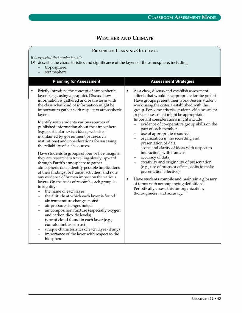
classroom assessment model
GeoGraphy 12 • 6�
prescrIbed learnInG outcomes
It is expected that students will:D1 describe the characteristics and significance of the layers of the atmosphere, including
– troposphere– stratosphere
Planning for Assessment Assessment Strategies
• Briefly introduce the concept of atmospheric layers (e.g., using a graphic). Discuss how information is gathered and brainstorm with the class what kind of information might be important to gather with respect to atmospheric layers.
Identify with students various sources of published information about the atmosphere (e.g., particular texts, videos, web sites maintained by government or research institutions) and considerations for assessing the reliability of such sources.
Have students in groups of four or five imagine they are researchers travelling slowly upward through Earth’s atmosphere to gather atmospheric data, identify possible implications of their findings for human activities, and note any evidence of human impact on the various layers. On the basis of research, each group is to identify− the name of each layer− the altitude at which each layer is found− air temperature changes noted− air pressure changes noted− air composition mixture (especially oxygen
and carbon dioxide levels)− type of cloud found in each layer (e.g.,
cumulonimbus, cirrus)− unique characteristics of each layer (if any)− importance of the layer with respect to the
biosphere
• As a class, discuss and establish assessment criteria that would be appropriate for the project. Have groups present their work. Assess student work using the criteria established with the group. For some criteria, student self-assessment or peer assessment might be appropriate. Important considerations might include− evidence of co-operative group skills on the
part of each member− use of appropriate resources− organization in the recording and
presentation of data− scope and clarity of ideas with respect to
interactions with humans− accuracy of data− creativity and originality of presentation
(e.g., use of props or effects, edits to make presentation effective)
• Have students compile and maintain a glossary of terms with accompanying definitions. Periodically assess this for organization, thoroughness, and accuracy.
weather and clImate
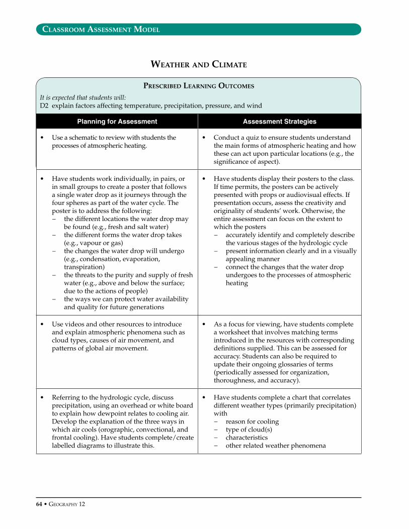
classroom assessment model
6� • GeoGraphy 12
prescrIbed learnInG outcomes
It is expected that students will:D2 explain factors affecting temperature, precipitation, pressure, and wind
Planning for Assessment Assessment Strategies
• Use a schematic to review with students the processes of atmospheric heating.
• Conduct a quiz to ensure students understand the main forms of atmospheric heating and how these can act upon particular locations (e.g., the significance of aspect).
• Have students work individually, in pairs, or in small groups to create a poster that follows a single water drop as it journeys through the four spheres as part of the water cycle. The poster is to address the following:− the different locations the water drop may
be found (e.g., fresh and salt water)− the different forms the water drop takes
(e.g., vapour or gas)− the changes the water drop will undergo
(e.g., condensation, evaporation, transpiration)
− the threats to the purity and supply of fresh water (e.g., above and below the surface; due to the actions of people)
− the ways we can protect water availability and quality for future generations
• Have students display their posters to the class. If time permits, the posters can be actively presented with props or audiovisual effects. If presentation occurs, assess the creativity and originality of students’ work. Otherwise, the entire assessment can focus on the extent to which the posters− accurately identify and completely describe
the various stages of the hydrologic cycle− present information clearly and in a visually
appealing manner− connect the changes that the water drop
undergoes to the processes of atmospheric heating
• Use videos and other resources to introduce and explain atmospheric phenomena such as cloud types, causes of air movement, and patterns of global air movement.
• As a focus for viewing, have students complete a worksheet that involves matching terms introduced in the resources with corresponding definitions supplied. This can be assessed for accuracy. Students can also be required to update their ongoing glossaries of terms (periodically assessed for organization, thoroughness, and accuracy).
• Referring to the hydrologic cycle, discuss precipitation, using an overhead or white board to explain how dewpoint relates to cooling air. Develop the explanation of the three ways in which air cools (orographic, convectional, and frontal cooling). Have students complete/create labelled diagrams to illustrate this.
• Have students complete a chart that correlates different weather types (primarily precipitation) with− reason for cooling− type of cloud(s)− characteristics− other related weather phenomena
weather and clImate

classroom assessment model
GeoGraphy 12 • 65
prescrIbed learnInG outcomes
It is expected that students will:D3 analyse specific weather phenomena, including
– fog– local winds– extreme events
Planning for Assessment Assessment Strategies
• Have students suggest causes of fog. Use their responses to introduce the conditions necessary for formation of radiation fog and advection fog. As a class, complete a labelled diagram to indicate where each type of fog would form.
• Provide map locations that variously refer to places where one or other type of fog would be likely to form. Have students create labelled sketches for each location and provide information on the type of fog that would likely form there (explaining why, if necessary). Assess students’ work for− accuracy of sketches− correct identification of the type of fog that
would form (and explanation)
• Use video resources or readings to introduce the many types of weather phenomena that exist, and their causes and effects.
• Provide students, individually or in groups, with a scenario of two locations in the same vicinity which could be experiencing different weather phenomena within a 24-hour period. Have them account for the differences. Assess their ability to relate weather effects to factors such as− aspect− insolation− lapse rate− air pressure− cloud cover− land and sea breezes− valley and mountain breezes
weather and clImate
continued next page

classroom assessment model
66 • GeoGraphy 12
Planning for Assessment Assessment Strategies
• If resources (thermometers, barometers, anometers, wind vanes, altimeters) are available and the topography of your community is appropriate, the study of different local weather phenomena could be performed outside the classroom. If a field study approach is used, the ideal setting and time would be September or May/June (greatest am/pm temperature differences) and close to water (experience land and sea breezes) which borders a hilly/mountainous terrain (experience mountain and valley breezes). Each half of the class is assigned to a different location, possibly on opposite sides of a lake (experience aspect). From there the two groups are further divided into smaller groups of approximately four each. At specific time intervals, all eight groups record data at each height and move on until data for all locations are recorded.
As two groups are involved, a second teacher may be required for supervision (e.g., the field study for this class could perhaps be combined with the field study for another class such as biology). At the end of the day the two main groups come together and share data. In a follow-up class, students theorize as to the difference in data recordings at different heights taken at the same time intervals.
• For a field study, assess the extent to which students − work co-operatively in groups− carefully and accurately record altimeter
data, anemometer data, barometer data, thermometer data, wind vane readings, and time of readings
− provide plausible explanations of controls responsible for weather data recorded
Weather and Climate (continued)
continued next page

classroom assessment model
GeoGraphy 12 • 6�
Planning for Assessment Assessment Strategies
• Provide a list of location-specific weather phenomena from around the world (e.g., local winds such as Mistral or Sirocco, local cooling or warming due to neighbouring ocean currents). Have students each choose one item from the list, or assign one per student. Students should prepare a report on− nature of the phenomenon (characteristic
or defining features)− causes of the phenomenon− impact on living organisms (as appropriate)− advantages and disadvantages for humans
• Have students share their findings with each other by organizing class presentations or by conducting exchanges within small groups (e.g., jigsaw). Students could provide peer assessments based on criteria such as− clarity of information presented (e.g.,
organization, formulation of findings)− inclusion of maps or other graphics (e.g., a
topological cross-section to explain a rain shadow)
− succinctness− extent to which all required categories have
been covered
As follow-up, conduct a matching quiz (i.e., matching a phenomenon from the original list with the corresponding description or identifying characteristic).
• Select one or two recent extreme weather events that students would be familiar with (e.g., major hurricane, tornado, ice storm, hail storm). As a class, create a chart to analyse these with respect to − location− path followed (e.g., storm track)− air masses involved− intensity and conditions experienced as
the event occurs− scope of damage− economic, social, and/or political
consequences
• Give students a different extreme weather event and have them each independently repeat the analysis undertaken as a class (allow for students to conduct research, if appropriate). Assess the extent to which students− address all aspects of the analysis as per
demonstration− follow the form modelled− provide accurate and complete information
Weather and Climate (continued)
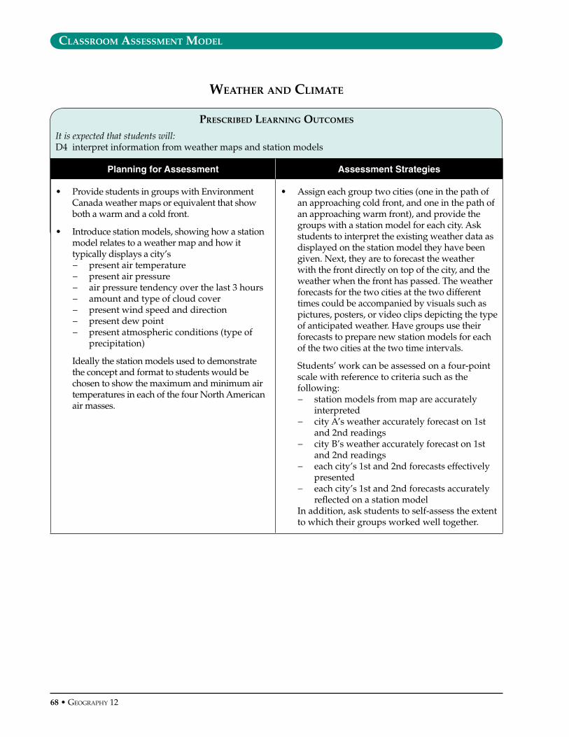
classroom assessment model
6� • GeoGraphy 12
prescrIbed learnInG outcomes
It is expected that students will:D4 interpret information from weather maps and station models
Planning for Assessment Assessment Strategies
• Provide students in groups with Environment Canada weather maps or equivalent that show both a warm and a cold front.
• Introduce station models, showing how a station model relates to a weather map and how it typically displays a city’s− present air temperature− present air pressure− air pressure tendency over the last 3 hours− amount and type of cloud cover− present wind speed and direction− present dew point− present atmospheric conditions (type of
precipitation)
Ideally the station models used to demonstrate the concept and format to students would be chosen to show the maximum and minimum air temperatures in each of the four North American air masses.
• Assign each group two cities (one in the path of an approaching cold front, and one in the path of an approaching warm front), and provide the groups with a station model for each city. Ask students to interpret the existing weather data as displayed on the station model they have been given. Next, they are to forecast the weather with the front directly on top of the city, and the weather when the front has passed. The weather forecasts for the two cities at the two different times could be accompanied by visuals such as pictures, posters, or video clips depicting the type of anticipated weather. Have groups use their forecasts to prepare new station models for each of the two cities at the two time intervals.
Students’ work can be assessed on a four-point scale with reference to criteria such as the following:− station models from map are accurately
interpreted− city A’s weather accurately forecast on 1st
and 2nd readings− city B’s weather accurately forecast on 1st
and 2nd readings− each city’s 1st and 2nd forecasts effectively
presented− each city’s 1st and 2nd forecasts accurately
reflected on a station model In addition, ask students to self-assess the extent
to which their groups worked well together.
weather and clImate
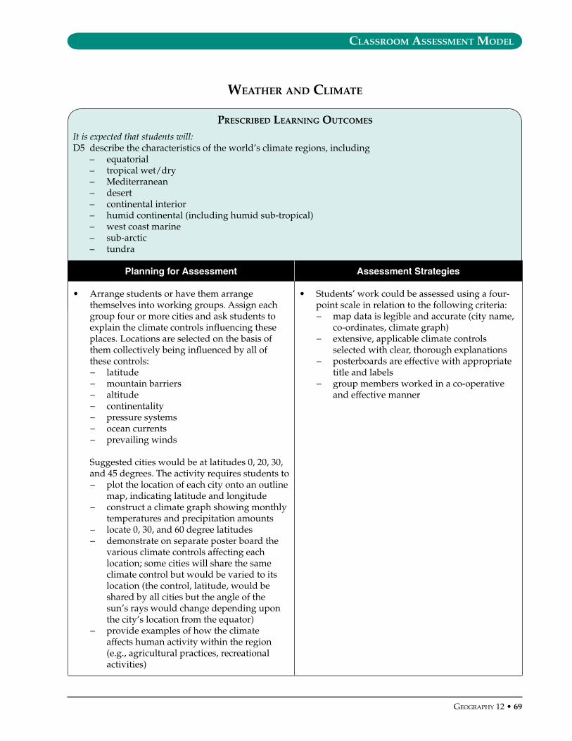
Classroom assessment model
GeoGraphy 12 • 69
PresCribed learning outComes
It is expected that students will:D5 describethecharacteristicsoftheworld’sclimateregions,including
– equatorial– tropicalwet/dry– Mediterranean– desert– continentalinterior– humidcontinental(includinghumidsub-tropical)– westcoastmarine– sub-arctic– tundra
Planning for Assessment Assessment Strategies
• Arrangestudentsorhavethemarrangethemselvesintoworkinggroups.Assigneachgroupfourormorecitiesandaskstudentstoexplaintheclimatecontrolsinfluencingtheseplaces.Locationsareselectedonthebasisofthemcollectivelybeinginfluencedbyallofthesecontrols:− latitude− mountainbarriers− altitude− continentality− pressuresystems− oceancurrents− prevailingwinds
Suggestedcitieswouldbeatlatitudes0,20,30,and45degrees.Theactivityrequiresstudentsto− plotthelocationofeachcityontoanoutline
map,indicatinglatitudeandlongitude− constructaclimategraphshowingmonthly
temperaturesandprecipitationamounts− locate0,30,and60degreelatitudes− demonstrateonseparateposterboardthe
variousclimatecontrolsaffectingeachlocation;somecitieswillsharethesameclimatecontrolbutwouldbevariedtoitslocation(thecontrol,latitude,wouldbesharedbyallcitiesbuttheangleofthesun’srayswouldchangedependinguponthecity’slocationfromtheequator)
− provideexamplesofhowtheclimateaffectshumanactivitywithintheregion(e.g.,agriculturalpractices,recreationalactivities)
• Students’workcouldbeassessedusingafour-pointscaleinrelationtothefollowingcriteria:− mapdataislegibleandaccurate(cityname,
co-ordinates,climategraph)− extensive,applicableclimatecontrols
selectedwithclear,thoroughexplanations− posterboardsareeffectivewithappropriate
titleandlabels− groupmembersworkedinaco-operative
andeffectivemanner
Weather and Climate
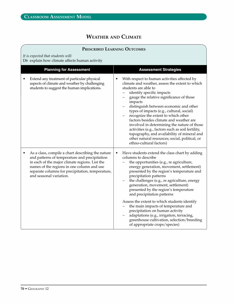
classroom assessment model
�0 • GeoGraphy 12
prescrIbed learnInG outcomes
It is expected that students will:D6 explain how climate affects human activity
Planning for Assessment Assessment Strategies
• Extend any treatment of particular physical aspects of climate and weather by challenging students to suggest the human implications.
• With respect to human activities affected by climate and weather, assess the extent to which students are able to− identify specific impacts− gauge the relative significance of those
impacts− distinguish between economic and other
types of impacts (e.g., cultural, social)− recognize the extent to which other
factors besides climate and weather are involved in determining the nature of those activities (e.g., factors such as soil fertility, topography, and availability of mineral and other natural resources; social, political, or ethno-cultural factors)
• As a class, compile a chart describing the nature and patterns of temperature and precipitation in each of the major climate regions. List the names of the regions in one column and use separate columns for precipitation, temperature, and seasonal variation.
• Have students extend the class chart by adding columns to describe − the opportunities (e.g., re agriculture,
energy generation, movement, settlement) presented by the region’s temperature and precipitation patterns
− the challenges (e.g., re agriculture, energy generation, movement, settlement) presented by the region’s temperature and precipitation patterns
Assess the extent to which students identify− the main impacts of temperature and
precipitation on human activity− adaptations (e.g., irrigation, terracing,
greenhouse cultivation, selection/breeding of appropriate crops/species)
weather and clImate

classroom assessment model
GeoGraphy 12 • �1
prescrIbed learnInG outcomes
It is expected that students will:D7 analyse interactions between human activity and the atmosphere, with reference to
– global climate change– ozone depletion– acid precipitation
Planning for Assessment Assessment Strategies
• Brainstorm ways in which human activity affects the atmosphere (e.g., ozone depletion, acid rain, global warming, smog).
• Assign groups of students an activity such as travelling to the beach for a summer afternoon, going to the ski slopes in the winter, or working at a part-time job. The purpose is to− describe the likely (or possible) impact
that actions associated with their assigned activity will have on the atmosphere and possibly the other three spheres
− suggest ideas to reduce and/or mitigate the impact
− explain why these suggestions are difficult to implement
The scope of the activity could be defined broadly enough to encompass steps taken from the time of waking up to going to bed. Presentation to the class would be by using one or more aids such as posters, video clips, photos, or group acting.
• Students’ work could be assessed using a four-point scale in relation to the following criteria:− all four issues (e.g., ozone depletion, acid
rain, global warming, smog) addressed− short-term impact of actions clearly and
thoroughly described− long-term implications clearly and
thoroughly described− a variety of plausible solutions provided− sound rationale provided as to why
solutions are difficult to implement
weather and clImate
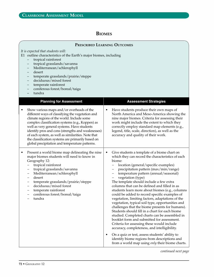
classroom assessment model
�2 • GeoGraphy 12
prescrIbed learnInG outcomes
It is expected that students will:E1 outline characteristics of the Earth’s major biomes, including
– tropical rainforest– tropical grasslands/savanna– Mediterranean/schlerophyll– desert– temperate grasslands/prairie/steppe– deciduous/mixed forest– temperate rainforest– coniferous forest/boreal/taiga– tundra
Planning for Assessment Assessment Strategies
• Show various maps and/or overheads of the different ways of classifying the vegetation and climate regions of the world. Include some complex classification systems (e.g., Koppen) as well as very general systems. Have students identify pros and cons (strengths and weaknesses) of each system, as well as similarities. Note that the classification systems are primarily based on global precipitation and temperature patterns.
• Have students produce their own maps of North America and Meso-America showing the nine major biomes. Criteria for assessing their work might include the extent to which they correctly employ standard map elements (e.g., legend, title, scale, direction), as well as the accuracy and quality of their work.
• Present a world biome map delineating the nine major biomes students will need to know in Geography 12:− tropical rainforest− tropical grasslands/savanna− Mediterranean/schlerophyll− desert− temperate grasslands/prairie/steppe− deciduous/mixed forest− temperate rainforest− coniferous forest/boreal/taiga− tundra
• Give students a template of a biome chart on which they can record the characteristics of each biome:− location (general/specific examples)− precipitation pattern (max/min/range)− temperature pattern (annual/seasonal)− vegetation (type)
The template should include a few extra columns that can be defined and filled in as students learn more about biomes (e.g., columns could be added to record specific examples of vegetation, limiting factors, adaptations of the vegetation, typical soil type, opportunities and challenges that the biome presents for humans). Students should fill in a chart for each biome studied. Completed charts can be assembled in booklet form and submitted for assessment. Criteria for assessing these would include accuracy, completeness, and intelligibility.
• On a quiz or test, assess students’ ability to identify biome regions from descriptions and from a world map using only their biome charts.
bIomes
continued next page
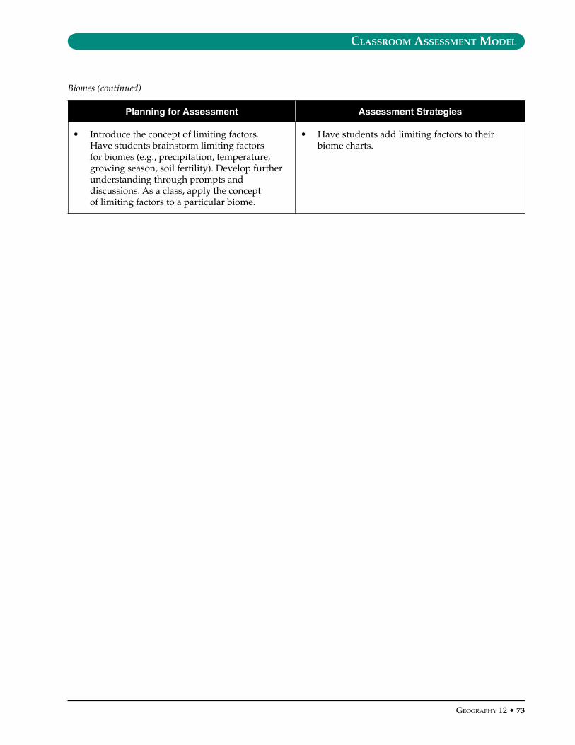
classroom assessment model
GeoGraphy 12 • ��
Planning for Assessment Assessment Strategies
• Introduce the concept of limiting factors. Have students brainstorm limiting factors for biomes (e.g., precipitation, temperature, growing season, soil fertility). Develop further understanding through prompts and discussions. As a class, apply the concept of limiting factors to a particular biome.
• Have students add limiting factors to their biome charts.
Biomes (continued)
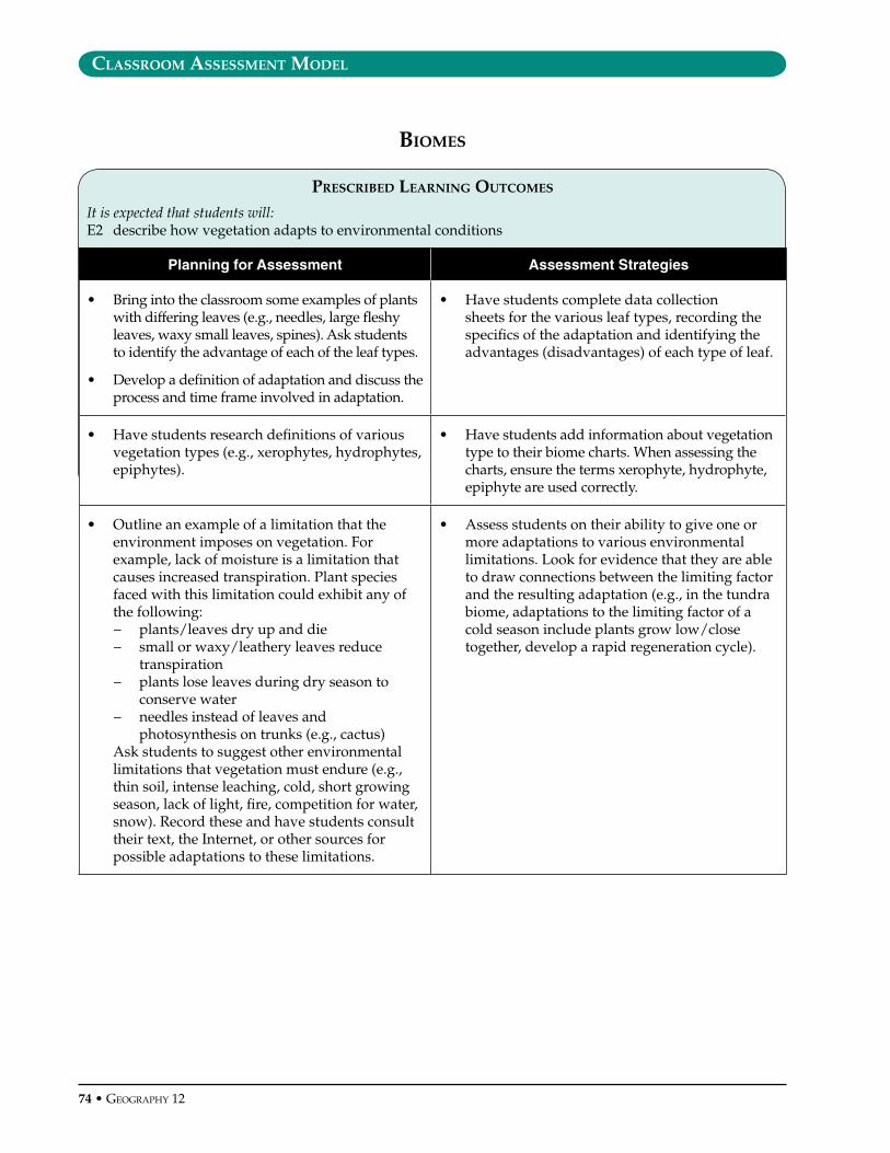
classroom assessment model
�� • GeoGraphy 12
prescrIbed learnInG outcomes
It is expected that students will:E2 describe how vegetation adapts to environmental conditions
Planning for Assessment Assessment Strategies
• Bring into the classroom some examples of plants with differing leaves (e.g., needles, large fleshy leaves, waxy small leaves, spines). Ask students to identify the advantage of each of the leaf types.
• Develop a definition of adaptation and discuss the process and time frame involved in adaptation.
• Have students complete data collection sheets for the various leaf types, recording the specifics of the adaptation and identifying the advantages (disadvantages) of each type of leaf.
• Have students research definitions of various vegetation types (e.g., xerophytes, hydrophytes, epiphytes).
• Have students add information about vegetation type to their biome charts. When assessing the charts, ensure the terms xerophyte, hydrophyte, epiphyte are used correctly.
• Outline an example of a limitation that the environment imposes on vegetation. For example, lack of moisture is a limitation that causes increased transpiration. Plant species faced with this limitation could exhibit any of the following:− plants/leaves dry up and die − small or waxy/leathery leaves reduce
transpiration − plants lose leaves during dry season to
conserve water− needles instead of leaves and
photosynthesis on trunks (e.g., cactus) Ask students to suggest other environmental
limitations that vegetation must endure (e.g., thin soil, intense leaching, cold, short growing season, lack of light, fire, competition for water, snow). Record these and have students consult their text, the Internet, or other sources for possible adaptations to these limitations.
• Assess students on their ability to give one or more adaptations to various environmental limitations. Look for evidence that they are able to draw connections between the limiting factor and the resulting adaptation (e.g., in the tundra biome, adaptations to the limiting factor of a cold season include plants grow low/close together, develop a rapid regeneration cycle).
bIomes

classroom assessment model
GeoGraphy 12 • �5
prescrIbed learnInG outcomes
It is expected that students will:E3 relate soil types to biomes
Planning for Assessment Assessment Strategies
• Outline the components of a soil (e.g., mineral fraction (sand/silt/clay), organic matter, water, air). Introduce the three-axis soil-texture diagram.
• Ask students to identify properties of each soil component and suggest what role each of the inorganic components of a soil (sand/silt/clay) might play.
• Have students determine the sand/silt/clay composition of various soil samples, using a soil-texture diagram and determine which soil is best for agriculture. They should explain their answers. Give feedback on both the accuracy of their analyses and their supporting reasons.
• Give students an outline of a typical well-developed soil profile. Using an overhead (colour) image of the same profile, have students make notes on the characteristics of each horizon in the profile. Define and identify the processes within the profile (leaching, capillary action, translocation).
• Locate an area around the school where several soil profiles can be examined. Take students outdoors to identify the horizons of soil profiles in the field: AO (litter), AE (leached), B (subsoil), C (parent material).
• When introducing processes associated with a soil profile, look for evidence that students are able to relate a soil profile to soil-forming processes they learned about when studying tectonics and gradation (e.g., translocation, capillary action, leaching).
• Assess student participation in the soil profile field activity. Look also for evidence that their work is careful, methodical, well-documented, and complete.
• Use a quiz to assess students’ knowledge of the processes and features associated with a typical soil profile.
• Have students produce diagrams of the five main soil profiles: podzol, chernozem, laterite, sierozem, tundra. A brief description of the composition and relative depth of the horizons as well as colour are useful discriminators. Included below each profile should be the following:− general type of vegetation each soil
supports (e.g., coniferous, xerophyte, tropical rainforest)
− the effects the vegetation has on the soil (e.g., nutrients provided, acidity of litter, root development)
− how climate influences the soil process (e.g., limits production of humus, heavy leaching, shallow/deep roots)
− the limitations of each soil type for vegetation in general and for agriculture in particular (e.g., moisture, depth, acidity, lack of humus)
• Given a simplified soil profile diagram or a description of a particular soil, assess students’ ability to identify the five main soil profiles and relate each to its key characteristics.
• Have students research the type of soil that corresponds to each of the nine biomes and add this information to their biome charts. Again, this should be assessed for accuracy, completeness, and intelligibility.
bIomes
classroom assessment model
�6 • GeoGraphy 12
prescrIbed learnInG outcomes
It is expected that students will:E4 analyse the interactions between human activity and biomes, with reference to
– deforestation– desertification– soil degradation– species depletion
Planning for Assessment Assessment Strategies
• Display the following quote: “Soil is more valuable than oil.” Ask the class if they agree or disagree with this statement. Have each side provide points (e.g., five) to support their particular position. Have each side share their supporting points.
• Give feedback on the validity and pertinence of students’ points. In particular, ensure that students have an appreciation for the value and vulnerability of soil as a renewable resource.
• Use text or video resources to introduce the various causes of soil degradation (e.g., over-cultivation, excessive fertilization, improper irrigation, deforestation), the consequences of each, and possible responses/solutions.
• Have students create a cause-effect flow chart (or cluster diagram) showing the relationships among the factors that contribute to soil degradation (over-cultivation, excessive fertilization, improper irrigation, deforestation), the consequences of each, and possible responses/solutions. Assess their work, looking at how well they have organized information to show important relationships. Accuracy and completeness should also be considered.
• Use text or video resources that highlight the impacts of human activities such as urbanization, waste disposal, and resource extraction on flora and fauna (e.g., loss of habitat, pollution, species depletion) and possible responses.
• As a class, discuss resources that humans need to survive (food, water, air, land, energy) and the sources of these.
• Divide the class into nine groups and assign one biome to each. Have groups brainstorm and research to compile ideas and information about− the opportunities their particular biome
could provide to humans− the limitations of their selected biome
Provide an opportunity for students to present their findings to classmates, who should record some limitations and opportunities for all nine biomes to add to their biome charts. Assess the presentations for pertinence, accuracy, clarity, and appeal (e.g., extent to which information is supported by appropriate visuals). Group members could also be asked to self-assess the functioning of their group and their own contribution to the group’s work.
bIomes

classroom assessment model
GeoGraphy 12 • ��
prescrIbed learnInG outcomes
It is expected that students will:F1 assess the various considerations involved in resource management, including
– sustainability– availability– social/cultural consequences– economic consequences– political consequences
Planning for Assessment Assessment Strategies
• Have students brainstorm types of resources. As a class, looking at the brainstormed list, come up with a definition of what constitutes a resource. Clarify the distinction between renewable and non-renewable resources, and have students sort their list of items into one or other category.
• Provide students with the definitions of sustainability. Have students brainstorm what can be done to sustain our resources.
• Have students add the terms renewable resources, non-renewable resources, and sustainability to an ongoing glossary of geographic terms that is assessed periodically for completeness, accuracy of definitions, and organization (e.g., alphabetical).
• Provide students with examples of articles dealing with an environmental issue or situation. Sources might include Canadian Geographic, National Geographic, Mother Jones, Earth Journal, Equinox, or Discovery. As a class, analyse an article using the following essential questions: − What issue(s) is (are) addressed?− What is the main argument and/or
conclusion?− What evidence is put forward to support
the argument(s) and/or conclusion(s)?− Who is the audience?− What are the article’s biases?− What are the differing points of views
related to the issue?− What side of the issue is not represented?− Why is it difficult to resolve this issue?
• Have students analyse one or more different articles, using the essential questions. Assess the extent to which they− answer all questions fully and coherently− draw reasonable inferences (e.g., concerning
audience, biases)− correctly cite supporting evidence from
the article for each of their answers, as appropriate
− express an opinion about the article that is compatible with the rest of their analysis
resources and envIronmental sustaInabIlIty
continued next page

classroom assessment model
�� • GeoGraphy 12
Planning for Assessment Assessment Strategies
• Have students create an environmental resource scrapbook. Students are to collect at least ten articles concerning a newsworthy environmental event related to the world’s renewable and non-renewable resources. They are to collect clippings from the local newspapers, provincial newspapers, national newspapers, Internet news services, and magazines.
• Assess scrapbooks using criteria such as the following: − a wide range of issues are represented from
a variety of sources− essential questions are answered for each
article− presented in an organized and professional
manner
• Provide students with examples of political cartoons related to resources. As a way of discussing political cartoons, their purposes, and methods, introduce students to the following analytical criteria for editorial cartoons:− What is the event or issue that inspired this
political cartoon? − Are there symbols in the cartoon? What do
they represent? − What kinds of ideas are included in political
cartoons? − Are there people in the cartoon? Who are
they, and what do they represent? − What is the subject of the cartoon? − What is the cartoonist’s point of view on
the subject?− How effective is this political cartoon?
Over a period of several weeks, have students create a cartoon portfolio containing political cartoons on particular resource topics as assigned.
• Have small groups of students each examine a particular cartoon dealing with resources or environmental sustainability, conducting an analysis using the criteria introduced. Then rearrange the groups to have students jigsaw their cartoons (i.e., each student explains to his or her new small group the cartoon’s message and the bias presented). Have students assess each other’s explanations of the cartoons, considering whether the following have been clarified:− the subject and apparent purpose of the
cartoon− the point of view− the assumptions
Students could present their cartoon portfolios orally to the class. Assess the students’ portfolios by considering the extent to which− each cartoon is mounted in a neat and
organized fashion− the cartoons in the portfolios represent the
assigned issues− for each cartoon, students have added a
commentary that identifies the subject, point of view (or bias), apparent objective, and relevant background needed to understand the cartoon, as well as an opinion on the cartoon’s effectiveness
− the students’ opinions on the effectiveness of cartoons reflects insight and are supported by evidence and coherent argument
See also the sample assessment instrument (Cartoon Portfolio) included at the end of this model.
Resources and Environmental Sustainability (continued)
classroom assessment model
GeoGraphy 12 • ��
prescrIbed learnInG outcomes
It is expected that students will:F2 assess the environmental impact of human activities, including
– energy production and use– forestry– fishing– mining– agriculture– waste disposal– water use
Planning for Assessment Assessment Strategies
• Divide the class into six groups and assign each group an energy source (e.g., fossil fuels, hydroelectricity, wind, nuclear, solar, geothermal). Ask them to conduct research and develop an oral presentation that answers the following essential questions:− How is the energy source created/
managed? − Who uses the energy source?− What are its benefits?− What are its drawbacks?
• Have student groups present their findings orally to their classmates. As each group presents, have the other students each take the notes needed to complete a chart on the six energy sources, using the Essential Questions as headings.
When evaluating the student presentations, consider using the sample assessment instrument supplied at the end of the Classroom Assessment Model (Oral Presentations on Sources of Energy). A quiz on energy sources can also be developed.
• Arrange students into teams and assign each team to prepare arguments on one side or the other of particular issues related to the forestry industry. Define the issues in terms of debate resolutions and have students conduct short informal debates on the basis of their preparation. Possible resolutions: − clearcutting is an obsolete harvesting
technique that should be abandoned in favour of selective logging
− threats to forest resources (e.g., fire, insect infestations, deforestation) should be addressed by natural checks and balances rather than managed through interventionist control programs
− private ownership and management of forest resources is a more effective and efficient approach than public ownership
Discuss criteria for a good debate on these resolutions (see Assessment Strategies column) and have the class observe as teams conduct their debates.
• Following each mini-debate, use peer assessment to give feedback to debate teams (this ensures involvement of the whole class on each issue), with reference to the criteria identified beforehand. These might include the extent to which− the rules of the debate are followed (e.g.,
avoiding inappropriate interruptions, sticking to time limits, giving turns to all team members, refraining from personal attacks or distracting behaviour)
− all major benefits and drawbacks of each position are identified (including reference to as many as possible of the considerations involved in resource-management decisions – social, economic, political, sustainability)
− preparation includes research to identify supportive evidence (e.g., facts and statistics, with sources correctly cited)
− arguments are developed coherently− rebuttals are relevant
Monitor how well both the debaters and classmates who give them subsequent feedback apply the criteria.
resources and envIronmental sustaInabIlIty
continued next page
classroom assessment model
�0 • GeoGraphy 12
Planning for Assessment Assessment Strategies
• Collect and display several pieces of garbage (students could be asked to gather these). Have students guess which pieces of garbage can be recycled, incinerated, or placed in a landfill (set induction). Use this to stimulate a class discussion on the topic of waste. Show a video on the subject of waste management.
• Have students create a chart on the benefits and drawbacks of each of the three forms of waste disposal: recycling, incineration, and landfill placement. Look for evidence that students’ charts have clearly identified the benefits and drawbacks of recycling, incineration, and landfill placement.
• Have students research various aspects of fishing (e.g., aquaculture, enhancement, commercial fishing) and create a children’s storybook on the fishing industry.
• Assess students’ work, looking for− understanding of the various forms of
fishing− analysis of the benefits and drawbacks of
each form− creativity with respect to presentation of
ideas
• In preparation for a round table discussion on the subject of mining, provide students with two case studies of potential mine sites: one a strip mine and the other a shaft mine. Divide the class into four groups:− Group 1: pro-strip mining− Group 2: con-strip mining− Group 3: pro-shaft mining− Group 4: con-shaft mining
Each group member could be assigned a particular point of view to keep in mind as they read their material (not all of these points of view need to be represented in each group, and some may be represented by more than one student):− geologist− environmentalist− health care worker− mine owner− member of local First Nation− member of local community− Premier of the province
Have students read the case studies, analyse the possible ramifications of the mine site, and together develop a set of points/arguments in support of their position.
• Reassemble the class and have groups present as follows:− Group 1 members present, for five minutes,
their views on Pro-Strip Mining; then Group 2 members present, for five minutes, their views on Con-Strip Mining; this is followed by a five-minute Question Period
− Group 3 members present, for five minutes, their views on Pro-Shaft Mining; then Group 4 members present, for five minutes, their views on Con-Shaft Mining; this is followed by a five-minute Question Period
Following the presentations, have each student write a final environmental impact assessment report on the development of the two mines. The report should contain the following information:− summary of the strip mine proposal− benefits for developing the strip mine− drawbacks for developing the strip mine− summary of the shaft mine proposal− benefits for developing the shaft mine− drawbacks for developing the shaft mine
Students will be evaluated on their participation in the small group discussion, round table discussion, questions, and environmental impact assessment report.
Resources and Environmental Sustainability (continued)
continued next page
classroom assessment model
GeoGraphy 12 • �1
Planning for Assessment Assessment Strategies
• Invite a local farmer or other agricultural person to class to discuss topics and issues associated with agriculture. Ask students to generate questions to ask the guest speaker. Questions could include the following:− What type of pest management system
do you use? …Why did you choose this method?
− What soil-related issues do you have to deal with (e.g., nutrients, erosion)? What steps do you take to deal with these issues?
− What type of equipment do you use?− What type of irrigation method(s) do you
use?− How do you dispose of agricultural waste?
• Assess the questions students ask (e.g., for insight exhibited, for relevance).
• Have students make notes on the presentation and record the speaker’s responses to questions. Following the presentation, have students analyse what they have heard by identifying the challenges and opportunities associated with the speaker’s agricultural operation and/or the benefits and drawbacks associated with the speaker’s agricultural practices. Assess students’ notes and analyses. How well do they reflect what the speaker said? Do they reflect a sophisticated understanding of the problems and possibilities associated with a particular type of agriculture (or with agriculture in general)?
• Have students each design an informational pamphlet on an aspect of Earth’s fresh water resources and the environmental impact of various human uses of water. The pamphlet should deal with the availability of water (locally or globally), problems, and possible solutions, in relation to one of the following topics: − domestic water use− the impact of agriculture (e.g., irrigation,
runoff)− industrial uses− the export of water (pros/cons)− water pollution− water-borne diseases− water conservation
Ensure that a range of topics is addressed within the class, so students’ pamphlets collectively cover a wide spectrum of issues.
• Have students share their work in a trade show form, so the class can circulate and look at each others’ work (as in a gallery walk). Assess student pamphlets using the sample assessment instrument (Earth’s Water Resources Informational Pamphlet) provided at the end of this Classroom Assessment Model.
Resources and Environmental Sustainability (continued)
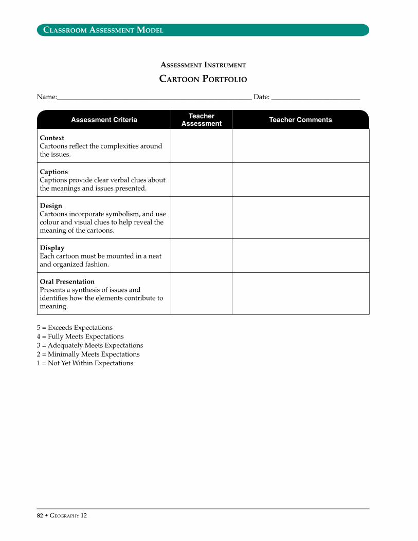
classroom assessment model
�2 • GeoGraphy 12
assessment Instrument
cartoon portfolIo
Name:_________________________________________________________ Date: __________________________
Assessment Criteria Teacher Assessment Teacher Comments
ContextCartoons reflect the complexities around the issues.
CaptionsCaptions provide clear verbal clues about the meanings and issues presented.
DesignCartoons incorporate symbolism, and use colour and visual clues to help reveal the meaning of the cartoons.
DisplayEach cartoon must be mounted in a neat and organized fashion.
Oral PresentationPresents a synthesis of issues and identifies how the elements contribute to meaning.
5 = Exceeds Expectations4 = Fully Meets Expectations3 = Adequately Meets Expectations2 = Minimally Meets Expectations1 = Not Yet Within Expectations

classroom assessment model
GeoGraphy 12 • ��
assessment Instrument
oral presentatIon on sources of enerGy
Energy Source: __________________________________________________________________________________
Presenters: _____________________________________________________________________________________
Assessment Criteria Teacher Assessment Teacher Comments
OrganizationIntroduces the topic with a clearly stated purpose. Sequencing and timing of presentation clear and effective.
DeliveryAppropriate voice and eye contact with audience. Pronunciation of key terms is correct.
�isualsVisual material is used effectively to clarify information presented.
KnowledgeFacts given are accurate, and analysis and insight are conveyed.
Thoroughness Essential questions are answered throughout presentation.
Research Effective use of time given for research.
SummaryMain ideas are summarized. Questions from audience are effectively answered.
5 = Exceeds Expectations4 = Fully Meets Expectations3 = Adequately Meets Expectations2 = Minimally Meets Expectations1 = Not Yet Within Expectations

classroom assessment model
�� • GeoGraphy 12
assessment Instrument
earth’s water resources InformatIon pamphlet
Name:_________________________________________________________ Date: __________________________
Assessment Criteria Teacher Assessment Teacher Comments
�isual �mpactUses colour, headings, diagrams and/or photos to illustrate knowledge of subject matter.
OrganizationInformation is organized in an effective way.
KnowledgeFacts given are accurate, and analysis and insight are conveyed.
Thoroughness Displays an understanding of• the value, uses, and availability of
fresh water• the threats associated with the topic
area• possible solutions to these threats
Research Effective use of time given for research.
5 = Exceeds Expectations4 = Fully Meets Expectations3 = Adequately Meets Expectations2 = Minimally Meets Expectations1 = Not Yet Within Expectations

learnInG resources
Geography 12


learnInG resources
GeoGraphy 12 • ��
This section contains general information on learning resources, and provides an Internet link to the titles, descriptions, and ordering
information for the recommended learning resources in the Geography 12 Grade Collection.
What Are Recommended Learning Resources?Recommended learning resources are resources that have undergone a provincial evaluation process using teacher evaluators and have Minister’s Order granting them provincial recommended status. These resources may include print, video, software and CD-ROMs, games and manipulatives, and other multimedia formats. They are generally materials suitable for student use, but may also include information aimed primarily at teachers.
Information about the recommended resources is organized in the format of a Grade Collection. A Grade Collection can be regarded as a “starter set” of basic resources to deliver the curriculum. In many cases, the Grade Collection provides a choice of more than one resource to support curriculum organizers, enabling teachers to select resources that best suit different teaching and learning styles. Teachers may also wish to supplement Grade Collection resources with locally approved materials.
How Can Teachers Choose Learning Resources to Meet Their Classroom Needs?Teachers must use either:• provincially recommended resources OR• resources that have been evaluated through
a local, board-approved process
Prior to selecting and purchasing new learning resources, an inventory of resources that are already available should be established through consultation with the school and district resource centres. The ministry also works with school districts to negotiate cost-effective access to various learning resources.
What Are the Criteria Used to Evaluate Learning Resources?The Ministry of Education facilitates the evaluation of learning resources that support BC curricula,
and that will be used by teachers and/or students for instructional and assessment purposes. Evaluation criteria focus on content, instructional design, technical considerations, and social considerations.
Additional information concerning the review and selection of learning resources is available from the ministry publication, Evaluating, Selecting and Managing Learning Resources: A Guide (Revised 2002) www.bced.gov.bc.ca/irp/resdocs/esm_guide.pdf
What Funding is Available for Purchasing Learning Resources?As part of the selection process, teachers should be aware of school and district funding policies and procedures to determine how much money is available for their needs. Funding for various purposes, including the purchase of learning resources, is provided to school districts. Learning resource selection should be viewed as an ongoing process that requires a determination of needs, as well as long-term planning to co-ordinate individual goals and local priorities.
What Kinds of Resources Are Found in a Grade Collection?The Grade Collection charts list the recommended learning resources by media format, showing links to the curriculum organizers and suborganizers. Each chart is followed by an annotated bibliography. Teachers should check with suppliers for complete and up-to-date ordering information. Most suppliers maintain web sites that are easy to access.
GeoGraphy 12 Grade collectIon
The Grade Collection for Geography 12 lists the recommended learning resources for this course. Resources previously recommended for the 1998 version of the curriculum, where still valid, continue to support this updated IRP. The ministry updates the Grade Collection on a regular basis as new resources are developed and evaluated.
Please check the following ministry web site for the most current list of recommended learning resources in the Geography 12 Grade Collection: www.bced.gov.bc.ca/irp_resources/lr/resource/gradcoll.htm
