geography curriculum guide (secondary 4-5) · pdf filegeography curriculum guide (secondary...
TRANSCRIPT

SECONDARY SCHOOLS CURRICULUM GUIDE
PERSONAL, SOCIAL AND HUMANITIES EDUCATION
KEY LEARNING AREA
GEOGRAPHY CURRICULUM GUIDE (SECONDARY 4-5)
PREPARED BY
THE CURRICULUM DEVELOPMENT COUNCIL RECOMMENDED FOR USE IN SCHOOLS BY THE EDUCATION AND MANPOWER BUREAU
HKSAR
2003

3
Contents
Page
Membership of the CDC Geography Subject Committee (Secondary) 4
Membership of the CDC Ad hoc Committee on the Review of S4-5 Geography Syllabus
5
Membership of the Joint CDC and HKEA Working Party on the Revision of S4-5 Geography Syllabus
6
Preamble 7
Introduction 8
Aims and Objectives 9
Curriculum Approach and Organization 11
Time Allocation 16
Themes 17
Issues 42
Guidelines for Teachers on Learning, Teaching and Assessment 49
Appendix: Reference and Resources List 85
4
Membership of the CDC Geography Subject Committee (Secondary)
(From September 1998 to August 1999)
Chairperson: Ms. CHAN Siu-chu, Helen
Vice-chairperson: Senior Curriculum Development Officer (Personal, Social and Humanities Education), Education Department (Mr. WONG Wang-fai)
Members: Ms. CHUNG Lai-kit
Dr. KWAN Yim-lin, Tammy
Mr. LAU Chi-hung
Prof. LEE Chi-kin, John
Mr. LI Tak-kun
Ms. LO Po-ling, Eileen
Mr. TO Ka-yan
Ms. WONG May-oi, Esther
Ms. WU Shuk-ting, Connie
Ex-officio Inspector (Geography), Education Department member: (Ms. CHUNG Siu-yee)
Secretary: Curriculum Development Officer (Personal, Social and Humanities Education), Education Department (Mrs. CHAN LEUNG Suk-ching)

5
Membership of the CDC Ad hoc Committee on the Review of the S4-5 Geography Syllabus
(Since March 2000)
Chairperson: Ms. CHAN Siu-chu, Helen
Vice-chairperson: Senior Curriculum Development Officer (Personal, Social and Humanities Education), Education Department (Mr. WONG Wang-fai)
Members: Ms. CHUNG Lai-kit
Dr. KWAN Yim-lin, Tammy
Mr. LAU Chi-hung
Prof. LEE Chi-kin, John
Mr. LI Tak-kun
Ms. LO Po-ling, Eileen
Mr. TO Ka-yan
Ms. WONG May-oi, Esther
Ms. WU Shuk-ting, Connie
Secretary: Curriculum Development Officer (Personal, Social and Humanities Education), Education Department (Mrs. CHAN LEUNG Suk-ching, up to June 2001) (Ms. CHAU Yuk-lin, Eunice, since June 2001)

6
Membership of the Joint CDC and HKEA Working Party on the Revision of S4-5 Geography Syllabus
(Since October 1998)
Chairperson: Mr. CHAN Chin-lee
Members: Ms. CHAN Siu-chu, Helen
Ms. CHUNG Lai-kit (since October 2000)
Mrs. HO AU-YEUNG Wai-yin
Mr. LAI Kwok-chan (up to August 2000)
Mr. LEE Yeung-chun, Eddy (since October 2000)
Mr. LI Tak-kun
Mr. TANG Kwok-cheung (since October 1999)
Mr. TO Ka-yan (up to August 2000)
Mrs. YU AU Man-chong (up to August 1999)
Ms. WU Shuk-ting, Connie
Secretaries: Senior Curriculum Development Officer (PSHE), Education Department (Mr. WONG Wang-fai)
Subject Officer (Geography), Hong Kong Examinations Authority (Mr. LAU Chi-hung, Thomas)

7
Preamble
This Curriculum Guide is one of the series prepared by the Hong Kong Curriculum Development Council for use in secondary schools. The Curriculum Development Council is an advisory body giving recommendations to the Hong Kong Special Administrative Region Government on all matters relating to curriculum development for the school system from kindergarten to sixth form. Its membership includes heads of schools, practising teachers, parents, employers, academics from tertiary institutions, professionals from related fields or related bodies, representatives from the Hong Kong Examinations and Assessment Authority and the Vocational Training Council, as well as officers from the Education and Manpower Bureau. This Curriculum Guide is recommended by the Education and Manpower Bureau for use in secondary schools. The curriculum developed for the senior secondary levels normally lead to appropriate examinations provided by the Hong Kong Examinations and Assessment Authority. The Curriculum Development Council will review the curriculum from time to time in the light of classroom experiences. All comments and suggestions on the Curriculum Guide may be sent to: Chief Curriculum Development Officer (Personal, Social and Humanities Education) Curriculum Development Institute Education and Manpower Bureau 13/F Wu Chung House 213 Queen’s Road East Wanchai Hong Kong

8
Introduction Geography is an indispensable discipline that enables us to understand the Earth we are living in from spatial and ecological perspectives. It provides a systematic framework for inquiry in order to find answers to questions about our surrounding world. Geography contributes significantly to secondary school education. Through the study of people, place and environment, geography provides students with a solid foundation to construct and integrate the knowledge and concepts from the natural sciences and the humanities. Moreover, in view of the new situations of the 21st C., geographical education helps prepare our secondary school graduates to face such challenges as population explosion, environmental pollution, economic transition, globalization, etc. On one hand, geographical education enables students to have a deeper understanding of our new world, new environment and new economy. On the other, it also provides sufficient opportunities for our students to develop generic skills including critical thinking, creativity, communication skills, information processing, interpersonal skills, and so on. In addition, through geographical inquiry, our students will be able to develop important abilities such as making values clarification and value judgement that provide a good foundation for whole-person development. On the whole, through inquiry of issues, geographical education provides students with the essential learning experiences in relation to the individual, the human society and the environment. Secondary school geographical education should aim at the development of basic geographic competency in our students. Apart from helping students to develop basic geographical concepts for further academic pursuit in post-secondary and tertiary education, it also equips the students with fundamental geographic knowledge and skills to tackle problems and challenges in their daily life. It is expected that after completing the secondary geographical education, each and every Secondary Five graduate will become a geographically informed person1 — a person “who sees meaning in the arrangement of things in space; who sees relations between people, places, and environments; who uses geographic skills; and who applies spatial and ecological perspectives to life situations.”
1 National Geography Standards, USA 1994
9
Aims and Objectives Aims
The aims of this curriculum are to enable student:
1. to recognize and understand the arrangement of phenomena and features on Earth as well as the inter-relationship and interaction among people, places and environments from spatial and ecological perspectives;
2. to develop geographical skills and basic competencies for further studies and life situations; and
3. to apply geographical knowledge and skills acquired for the betterment of individuals, the society, the nation and the world.
Objectives
In relation to the above aims, students should, after completing this curriculum, be able to:
Knowledge and Understanding 1. know and understand spatial concepts such as location, distribution, pattern, etc. in
order to analyze the spatial organization of natural and human phenomena and features within a geographical framework;
2. identify and explain the characteristics of the major natural systems of the Earth and to analyze the interactions within and between these systems;
3. identify and explain the characteristics of the major human systems of the Earth in order to achieve a sense of place and region;
4. explain how human activities alter natural environments and how natural systems influence human systems;
5. apply geographical knowledge to interpret the past and the present as well as to plan for the future;

10
Skills
1. master basic geographical skills, for example: 1.1 read and interpret a variety of maps at different scales; 1.2 interpret ground and aerial photographs to extract and analyze geographical
information from them; 1.3 observe, measure and record data (including interview) systematically and
accurately; 1.4 construct and test hypotheses in order to solve geographical problems; 1.5 use appropriate geographical terminology to present materials and arguments;
2. master basic inquiry skills, for example: 2.1 ask and identify questions from a geographical perspective; 2.2 locate and collect appropriate information and data from a variety of sources
(including the Internet); 2.3 select and use appropriate formats, such as texts (reports, tables, summaries, etc.)
and illustrations (diagrams, models, maps, sketches, statistical graphs, climatic graphs, etc.) to organize and present information and data;
2.4 use appropriate methods (e.g. analysis, synthesis, comparison, evaluation) to interpret information and data for making inferences and drawing conclusions;
2.5 evaluate the answers, solutions or conclusions drawn from inquiry;
3. master basic competencies, such as communication, thinking, social and numeracy skills for geographical inquiry and life situations;
Attitudes and Values
1. show interest in various natural and human characteristics;
2. appreciate the beauty of nature and the different living conditions of people;
3. be aware of environmental limitations and problems and take appropriate action to promote sustainable development;
4. cultivate a sense of belonging to their society and nation;
5. show respect for all peoples, their cultures, values and ways of life; and
6. be aware of the increasing global interdependence of peoples and nations, and understand the importance of international solidarity and cooperation.

11
Curriculum Approach and Organization It is proposed that thematic studies approach is to be adopted for structuring the curriculum. This curriculum is comprised of two parts –– themes and issues. The ‘themes’ component of the curriculum will include six themes. The main purpose of this part is to help students acquire and construct basic geographic knowledge and concepts in a systematic way. In turn this can provide students with a solid foundation for further academic study in post-secondary level and equip them with the basic geographic knowledge and skills essential for their daily life situations. The criteria for selecting the themes are as follows:
1. The themes should include all the major geographic knowledge and concepts and provide a balanced coverage of physical and human geography;
2. After completing the study of these themes, students should have acquired basic geographic knowledge, concepts and skills that could be used to meet the need of daily life. At the same time, they should also be provided with a concrete foundation to pursue the more academic post-secondary geography curriculum; AND
3. Each of the themes should be related to at least one of the issues selected for this curriculum.
The ‘issues’ component is comprised of six issues which aims at helping students develop inquiry and thinking skills. It also provides opportunities for students to apply what they have acquired to real life situations. The criteria for selecting the issues are as follows:
1. The issues should include local, national and global-scale case studies;
2. The scope of each issue (both the depth and the breadth of the content) should be approximately the same;
3. The issues should be contemporary ones, capable of drawing persistent public attention for a reasonable period of time;
4. Issues selected should avoid overlapping with those suggested in the junior secondary curriculum; AND
5. Each issue should be related to at least one of the themes selected for this curriculum.

12
Organization of the S4-5 Geography Curriculum
Themes
How we modify our world
Agriculture
City Industry
Landform andEndogenetic
Processes
Landform andExogeneticProcesses
Climate
How nature shapes our world
IssuesIssues arising from people-
environment interaction
The Choiceof Power
NaturalHazards
Food andHunger
TheTrouble of
Water
SustainableCity
ClimaticAnomalies
It is recommended that the themes and issues in this curriculum should be dealt with in
a cohesive and integrative way. Each theme or issue should not be treated as a separated
unit independent of one another. In fact, this curriculum is designed in such a way that
there exists a number of possible ways of integrating various themes and issues into one
single and complete unit of learning. Teachers are thus advised to combine themes and
issues whenever possible so that while students are provided with the opportunities of
learning geographical concepts and knowledge in a systematic way, they can also at the
same time apply what they have acquired into real life situations. It is suggested that
teachers can first guide their students to carry out issue inquiry and in turn help them to
study the related themes during the inquiry. On the other hand, teachers can also begin
with the study of the theme and then guide students to inquire the related issues. As these
two approaches have their own merits and demerits, teachers should not adhere strictly to
any one of them but are advised to select the one that can best suit the interests, needs and
ability of their students.

13
To facilitate teachers in the design of school-based curriculum, two examples showing
the integration of issues and themes in the teaching of this curriculum are given in the
following two pages for teachers’ reference. Teachers should note that the "one issue to
one theme" approach shown in the examples is not the only possible way of combining
issues and themes. It is also advisable for teachers to consider integrating several different
“issues” and “themes” in their plans.

14
From Issue Inquiry to Thematic Study
Guiding Questions
Explanatory Notes on Learning Content
What is happening in Sahel? Are there any other places suffering from the same problem?
♦ Regions frequently affected by famine ♦ Characteristics of regions frequently affected by
famine
What is famine? What are the similarities found in the countries affected by famine?
♦ Definition of famine ♦ Physical and human factors leading to the
occurrence of famine
Where is Sahel? What are the characteristics of its natural environment? How does the natural environment affect agriculture in Sahel?
♦ Location of Sahel ♦ Characteristics of the natural environment in Sahel♦ The main components of an agricultural system
(simple input-output model) ♦ Relationship between physical factors and
agriculture ♦ Characteristics of agriculture in Sahel ♦ Physical factors affecting nomadic herding in Sahel
Where is Southern California? What are the characteristics of its natural environment?
♦ Location of Southern California ♦ Characteristics of the natural environment in
Southern California ♦ Characteristics of irrigation farming in Southern
California ♦ Physical factors affecting agriculture in Southern
California
Why are the characteristics of agriculture in Sahel so different from those in Southern California despite their similar natural environmental settings?
♦ Relationship between human factors and agriculture
♦ Agricultural systems of nomadic herding and irrigation farming
♦ Similarities and differences of agriculture in Sahel and Southern California
♦ Reasons for the differences in agricultural characteristics between Sahel and Southern California
In what ways is technology affecting the agriculture in the two regions? Is technology a panacea for improving agricultural production?
♦ The impact of technology on agriculture in Sahel and Southern California
♦ Positive and negative impacts of technology on agriculture
Why do some regions have surplus food production whereas other regions are suffering from famine? Is famine a natural or man-induced disaster?
♦ Factors determining agricultural productivity ♦ Physical and human factors leading to famine
Can international aids help those countries affected by food shortage and famine effectively? Or are they just doing bad jobs with good motives?
♦ Possible ways in solving the problem of famine ♦ Types of international aids ♦ Problems resulted from international aids
Why should we bother about the famines in other countries or regions?
♦ The impact of famine on the affected region ♦ Global impact of famine ♦ Possible individual actions in helping people in
regions affected by famine

15
From Thematic Study to Issue Inquiry
Guiding Questions
Explanatory Notes on Learning Content
What are the differences between nomadic herding in Sahel and irrigation farming in Southern California?
♦ The main components of an agricultural system (simple input-output model)
♦ The agricultural systems of nomadic herding and irrigation farming
Where is Sahel? Where is Southern California? What are the characteristics of the natural environments in these two regions?
♦ Location of Sahel and Southern California ♦ Characteristics of the natural environments in Sahel
and Southern California
How does the natural environment affect agriculture in these two regions?
♦ Relationship between physical factors and agriculture
♦ Physical factors affecting agriculture in Sahel ♦ Physical factors affecting agriculture in Southern
California
Why do the agricultural characteristics vary in these two regions of similar natural environmental settings?
♦ Similarities and differences of agriculture in Sahel and Southern California
♦ Relationship between human factors and agriculture
♦ Reasons for the differences in agricultural characteristics between Sahel and Southern California
Is technology a panacea for improving agricultural production? What is the negative impact of agricultural technology in these two regions?
♦ Positive and negative impacts of technology on agriculture
♦ Technological impact on agriculture in Sahel and Southern California
Sahel has been frequently affected by famine. How does this problem relate to the local technological level?
♦ Definition of famine ♦ Physical and human factors leading to famine ♦ Factors determining agricultural productivity
What are the other regions that are also frequently affected by famine? What are the similarities that can be found in Sahel and these regions?
♦ Regions frequently affected by famine ♦ Characteristics of regions frequently affected by
famine
Is famine a natural or man-induced disaster? ♦ Reasons for famine to occur frequently
Can international aids help those countries affected by food shortage and famine effectively? Or are they just doing bad jobs with good motives?
♦ Possible ways to solve the problem of famine ♦ Types of international aids ♦ Problems resulted from international aids
Why should we bother about the famines in other countries or regions?
♦ The impact of famine on the affected region ♦ Global impact of famine ♦ Possible individual actions in helping people in
regions affected by famine

16
Time Allocation This curriculum is compiled on the assumption that schools will allocate a minimum of 150 learning periods for geography (at least 4 periods per week). Schools are advised to assign a double lesson to the teaching of geography at least once a week. It is recommended that fourteen periods should be assigned for each theme and nine periods should be assigned for each issue. Students on average would be able to complete the whole curriculum content within 138 teaching periods. Teachers should exercise their own discretion to allocate the remaining time for various purposes, such as catering for the more extensive needs of students, provision of guidance for the academically less able students, carrying out more in-depth inquiry of a particular issue, or employment of a greater variety of learning strategies.

17
Themes

18
Agriculture Introduction The characteristics of different agricultural landscapes in the world have always been
shaped by the interaction among physical and human factors. During the past few decades,
owing to technological advancement, human beings have gained greater control over the
natural environment. Thus, the importance of physical factors affecting agriculture has
been reduced drastically whereas technology is playing a more important role. Using
agricultural technology as the organizing concept, this theme aims at investigating how
different technological inputs produce different agricultural characteristics in two
different areas with similar natural environment. The focus is to examine how human
beings use technology to overcome the agricultural constraints posed by physical and
human factors, how variation in technological level determines agricultural characteristics,
and the positive and negative impacts of agricultural technology on agricultural activities.

19
Organizing Concepts
Theme: Agriculture
Regions with lowtechnology level1. Characteristics of the agricultural system2. Factors affecting agricultural characteristics3. The role and impact of agricultural technology4. Measures to sustain a balance between the use of technology and the environment5. Case study: Nomadic herding in Sahel
Regions with hightechnology level1. Characteristics of the agricultural system2. Factors affecting agricultural characteristics3. The role and impact of agricultural technology4. Measures to sustain a balance between the use of technology and the environment5. Case study: Irrigation farming in Southern California
AgriculturalTechnology

20
TechnologyLess DevelopedRegion -- low
technological level
Irrigationfarming inSouthernCalifornia
Positive and negative impactsof agricultural technology
Measures to sustain a balance betweenthe use of technology and the
environment
Why are theagricultural
characteristics sovaried even withsimilar naturalenvrionmental
settings?
Other factors affectingagricultural characteristics
Nomadicherding in
Sahel
More DevelopedRegion -- high
technological level

21
Key Learning Elements
Knowledge / Concepts
♦ Agricultural system
− The major inputs, processes and outputs of an agricultural system ♦ Physical and human factors affecting agriculture
− The main characteristics of the physical and human inputs of the agricultural systems in Sahel and Southern California
− The reasons for the varying agricultural characteristics in Sahel and Southern California even though the natural environment of the two places are very similar
♦ The use of agricultural technology to overcome agricultural constraints (e.g. lack of water, infertile soils) in Sahel and Southern California
♦ Negative impact of agricultural technology in Sahel and Southern California
− Problems of overusing and misuse of agricultural technology − Measures to sustain a balance between the use of technology and the
environment Skills ♦ Correlate aerial photos with maps and use the evidence to
recognize the main characteristics and patterns of different agricultural activities
♦ Design questionnaire for interviewing local farmers about how the natural environment and technology influence agricultural activities
♦ Select appropriate methods to collect information about nomadic herding and irrigation farming
♦ Select and organize appropriate materials (e.g. graphs, photos, statistical data and video clips) to describe the similarities and differences of nomadic herding and irrigation farming
♦ Summarize the positive and negative impacts of technology on agriculture from the information collected from various sources
Values/ Attitudes ♦ Understand the limitation of agricultural technology
♦ Be aware of the advantages and disadvantages of technology
♦ Show concern about difficulties encountered by people in other areas, and take action to help them
Case Studies Nomadic herding in Sahel and irrigation farming in Southern California Suggested number of periods 14 periods

22
City Introduction The urban population density of Hong Kong is one of the highest in the world. In addition
to the environmental problems brought by such a high density, the city is also facing a
pressing need for additional housing and related infrastructure resulting from the
foreseeable increase in her urban population. The rapid urban growth aroused increasing
attention from the general public and a strong demand for careful urban planning and
design. There is an urge for the government to adopt a sustainable development strategy
for Hong Kong. This theme aims at studying the process and impact of urban
development on Hong Kong, with the emphasis on urban renewal in the inner city and
urban encroachment in the rural areas. Teachers should also help students understand the
extent to which the planning strategies of the Hong Kong government have been
successful in alleviating the problem.

23
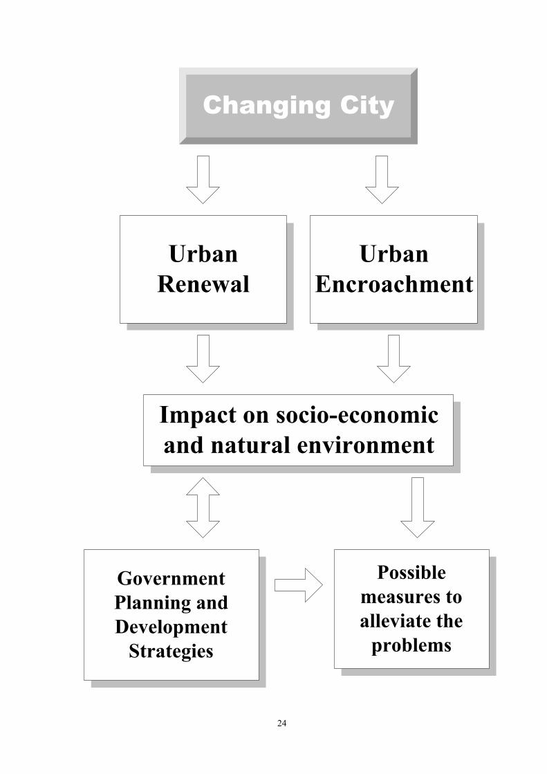
Organizing Concepts
Theme: City
Urban Renewal1. Process2. Impact on socio- economic and natural environment3. Possible strategies to alleviate the problems
UrbanEncroachment1. Process2. Impact on socio- economic and natural environment3. Possible strategies to alleviate the problems
ChangingCity
24
Changing City
UrbanRenewal
UrbanEncroachment
Impact on socio-economicand natural environment
Possiblemeasures toalleviate the
problems
GovernmentPlanning andDevelopment
Strategies

25
Key Learning Elements
Knowledge / Concepts
♦ Urbanization in Hong Kong
− The reasons for people moving into the city − The impact of such process on land use pattern
♦ Changing urban morphology through time
− Changes in the land use pattern of Hong Kong in the past few decades
♦ Urban renewal and urban encroachment in Hong Kong
− Processes and characteristics − Resulting socio-economic and environmental problems − Possible solutions to the above problems
♦ Conflict between environmental conservation and urban development in Hong Kong
− Hong Kong’s urban planning strategies: some basic principles − Measures taken by the Hong Kong government in recent years
Skills ♦ Identify and interpret different types of urban problems with the aids of photos and maps
♦ Conduct questionnaire survey (including questionnaire design and interview) to find out the priority given by people on environmental conservation and urban development and reasons behind their choice
♦ Collect information from different sources concerning Hong Kong’s urban planning and development strategies
♦ Draw land use maps to show the changing land use pattern of a local urban district
♦ Analyze the reasons for supporting and objecting a development project
Values/ Attitudes ♦ Develop sensitivity to the development of the surrounding environment
♦ Show concern for the problems caused by urban development
♦ Develop a sense of responsibility and willingness to take action in protecting and improving urban environment
Case Study Hong Kong Suggested number of periods 14 periods

26
Climate Introduction The atmosphere can be compared to a giant heat engine. The energy required for its
operation comes from the sun. Owing to different angles of incidence, there is an uneven
distribution of insolation on the Earth's surface. With reference to this uneven distribution,
this theme starts with dividing the Earth into two major climatic regions – the low-latitude
region and the middle and high-latitude region. Students will first study the climatic
characteristics of these two regions using the four selected case studies. They will then be
guided to find out the major factors, in addition to insolation, that affect the climates of
these two regions. Subsequently, students will make use of the case studies for each of the
two regions to investigate why climate varies in areas of similar latitudes. The main aim
of this theme is to help students understand the major factors affecting climate and their
complex interrelationship through inquiry learning.

27
Organizing Concepts
Theme: Climate
Low-latitudeRegion:1. Climatic characteristics2. Factors affecting climate3. Case studies: Tropical Humid Climate Tropical Arid Climate
Insolation
Middle and High-latitude Region:1. Climatic characteristics2. Factors affecting climate3. Case studies: Temperate Maritime Climate Temperate Continental Climate

28
Insolation
Climatic CharacteristicsOther major climatic factors in
addition to insolation
Why does climate vary in regions ofsimilar latitudes?
Low-latitude Regions Middle and High-latitude Regions
Uneven Distribution of Insolation
Case Studies:Tropical Humid
ClimateTropical Arid
Climate
Case Studies:Temperate Maritime
ClimateTemperate Continental
Climate

29
Key Learning Elements
Knowledge / Concepts
♦ Distribution pattern of insolation on the Earth’s surface − Global distribution pattern of insolation on the Earth’s surface − Reasons for the latitudinal differences found in the distribution pattern of
insolation ♦ Relationship between insolation and the global distribution pattern of
temperature, precipitation, wind and pressure − Global distribution pattern of temperature, precipitation, pressure and wind − Relationship between insolation and global temperature distribution pattern − Interrelationship among the global distribution pattern of temperature,
precipitation, pressure and wind ♦ Climate of the low-latitude region as well as the middle and
high-latitude region (with reference to the four case studies) − Major factors affecting the climates of the low-latitude region as well as the
middle and high-latitude region − Reasons for climatic variations in areas of similar latitudes
♦ The impact of climate on human beings (on their livelihood and production) − Examples: daily life, population distribution, agriculture
Skills ♦ Identify the climatic characteristics and distribution pattern from climatic maps and graphs
♦ Collect climatic data of Hong Kong by visiting the Hong Kong Observatory Resource Centre and interpret the trend of Hong Kong’s climatic change over a long period of time from the collected data
♦ Locate and select data from different information sources in order to collect appropriate climatic information and data
♦ Plot climatic graphs according to climatic data ♦ Highlight the climatic characteristics, similarities and differences of
two different climatic regions using climatic graphs/maps and other appropriate presentation methods (e.g. text and table)
♦ Compare the global distribution pattern of insolation, temperature, precipitation and pressure and identify the relationship among them
Values/ Attitudes
♦ Show concern for the impact of climatic changes on the global environment and our future generation
Case Studies Low-latitude region: Tropical humid climate and Tropical arid climate (Malaysia; Somalia) Middle and high-latitude region: Temperate maritime climate and Temperate continental climate (Shandong; Xinjiang) Suggested number of periods 14 periods

30
Industry Introduction The study of various factors influencing industrial location has always been a key topic in
geography. The aim of this theme is to study the factors affecting industrial location using
iron and steel industry and information technology industry as examples. Iron and steel
industry is chosen because it serves as a typical example for studying the change of
factors affecting industrial location through time. The location of iron and steel industry
has experienced several major changes as a result of technological breakthrough. These
changes in the location are mainly due to the replacement of one dominating factor by
another although the production is still being concentrated on a particular site
(single-point production). On the other hand, the study of the location of information
technology industry introduces another group of location factors, such as human
resources and research and development, other than the traditional ones like power, raw
materials and market. In general, the location of information technology industry is not
dominated by any particular locational factor and its production site is not confined to a
particular city or region (multi-point production). The industry has been developing
towards a transnational enterprise model characterized by cross-regional or cross-national
production.

31
Organizing Concepts
Theme: Industry
Iron and SteelIndustry1. Heavy industry2. Raw material-oriented to market-oriented3. Single-point production4. Industrial inertia
InformationTechnologyIndustry1. Light industry2. Footloose industry3. Transnational and multi- point production4. Human resources, research and development
ChangingLocational
Factors

32
Changing Locational Factors
Location of Ironand Steel Industry
Impact of industrial relocation andappearance of new production mode
TraditionalFactors
(raw materials andpower)
TechnologicalFactor
New Factors(human resources,
research anddevelopment)
Location ofInformationTechnology
Industry

33
Key Learning Elements
Knowledge / Concepts
♦ Major factors affecting the location of industry − Traditional dominant factors, such as power, raw materials − The role of technology − Other locational factors with increasing significance in recent years, e.g.
human resources, research and development ♦ Location of iron and steel industry
− Factors affecting the location of iron and steel industry − Changing location of iron and steel industry and the role of technology − Industrial inertia in iron and steel industry
♦ Location of information technology industry − Factors affecting the location of information technology industry − Multi-point and transnational production: characteristics and reasons for its
appearance ♦ The impact of industrial relocation and appearance of new production
mode − Examples: urban decay, unemployment, flow of labour
Skills ♦ Draw maps to illustrate the changing location of iron and steel industry and information technology industry
♦ Formulate hypotheses on the impact of industrial relocation on workers and other industries within the industrial area and verify them through questionnaire survey in the field
♦ Collect information on iron and steel industry and information technology industry from various sources (e.g. the Internet)
♦ Contrast the main locational factors of iron and steel industry and information technology industry using various appropriate presentation modes (such as table, graph and computer presentation)
♦ Organize the first-hand and second-hand materials collected in order to analyze the impact of industrial relocation on workers and the society
Values/ Attitudes
♦ Recognize the effort of human beings on the development of modern industry
♦ Appreciate the far-reaching impact of technological development ♦ Recognize the trend of globalization ♦ Understand and show concerns for problems caused by the changes in
industrial location Case Studies Iron and steel industry in China and information technology industry in U.S.A Suggested number of periods 14 periods

34
Landform and Endogenetic Processes Endogenetic processes refer to the processes generated within the interior of the Earth.
They force the Earth’s crust to converge, diverge or shear. These in turn give rise to
folding, faulting and vulcanicity that will occasionally be accompanied by volcanic
eruptions and earthquakes. The major landform features found on the Earth’s surface are
mainly the results of the endogenetic and the exogenetic processes. This theme adopts
plate tectonics as the organizing concept to explain how plate movement resulting from
endogenetic processes creates the mountain systems and other large-scale landform
features in Asia-Pacific Region. Teachers should note that the focus of this topic is to
enable students understand the relationship between plate tectonics and endogenetic
processes (mainly folding, faulting and vulcanicity) from a macro perspective. Students
should be able to acquire basic knowledge on the formation and characteristics of the
major macro-scale landform features formed by the endogenetic processes, such as fold
mountain, island arc, ocean trench, volcano, mid-oceanic ridge and rift valley. Teachers
should help students integrate knowledge acquired in this theme with those in the theme
“Landform and Exogenetic Processes” to develop a complete knowledge framework. In
this way, student can develop an understanding of how the major landform features on the
Earth are formed.

35
Organizing Concepts
Theme: Landform and EndogeneticProcesses
Constructive PlateBoundary1. Major endogenetic processes: faulting, vulcanicity2. Resultant landform features: mid-oceanic ridge, volcano, rift valley
Destructive PlateBoundary1. Major endogenetic processes: folding, faulting, vulcanicity2. Resultant landform features: fold mountain, island arc, volcano, ocean trench
PlateMovement

36
Plate Movement
Plate collision
Convergence
Resultant phenomena: volcanic eruptions, earthquakes, tsunamis
Divergence
Sea-floor Spreading
Continental plate(Eurasian Plate)
+Continental plate(Indo-Australian
Plate)
Continental plate(Eurasian Plate)
+Oceanic plate(Pacific Plate)
Oceanic plate(Nazca Plate)
+Oceanic plate(Pacific Plate)
Fold mountain(The Himalayas)
Island arc(Japan/the
Philippines)
Mid-oceanic ridge(East Pacific Rise)

37
Key Learning Elements
Knowledge / Concepts
♦ Major endogenetic processes
− Folding, faulting, intrusive and extrusive vulcanicity ♦ Plate tectonics in Asia-Pacific Region
− Distribution of continental and oceanic plates − Types of plate boundaries: constructive, destructive and conservative
♦ Resultant landform features of plate convergence and divergence in Asia-Pacific Region
− Formation and characteristics of major landform features found at constructive and destructive plate boundaries, e.g. fold mountain, island arc, ocean trench, volcano, mid-oceanic ridge and rift valley
− The relationship among plate movement, endogenetic processes and resultant landform features
♦ The impact of endogenetic processes on human beings
− Examples: the impact of the distribution of mineral and power resources, natural hazards such as volcanic eruptions, earthquakes and tsunamis
Skills ♦ Identify landform features in contour maps, relief maps and photos
♦ Locate landform features during field study with the aid of maps and photos
♦ Select appropriate maps and information for conducting field study
♦ Describe the formation and characteristics of a designated landform features with the aid of diagrams, photos and other information or data
♦ Carry out a project study on the formation and characteristics of a particular landform feature observed in field trip
Values/ Attitudes
♦ Appreciate the interdependence between human beings and the natural environment
Case Studies Asia-Pacific Region (from Himalayas to Easter Island) Suggested number of periods 14 periods

38
Landform and Exogenetic Processes
Exogenetic processes refer to the processes which occur at or near the surface of the Earth.
They usually involve differential wearing away of rocks and subsequent deposition of the
resulting debris. Erosion is the most significant part of the exogenetic processes in
shaping the landform on the Earth’s surface. Large-scale landform features produced by
erosion can be found on nearly every corner of the Earth. There are four types of erosion,
namely fluvial, glacial, wave and wind erosion, among which fluvial erosion is the most
common. Strictly speaking, any type of erosion, regardless of its erosional agent, can be
further divided into three processes, i.e. breakdown, carriage and removal. Moreover,
when erosion comes to a stop, it will be followed immediately by the process of
deposition. Because of this commonality, this theme adopts ‘fluvial processes’ as the
organizing concept to help students master the basic knowledge of river erosion and
deposition, and understand how they change along the river course from high mountains
to the seashore. A complete conceptual framework can then be composed to explain the
formation and characteristics of resultant landform features at different courses of the
river. With such a framework developed in mind, it is hoped that students will find it
easier to learn the other three types of erosion in the future.

39
Organizing Concepts
Theme: Landform andExogenetic Processes
Erosion1. Processes and characteristics2. Resultant landform features3. Factors affecting erosion4. Erosion at different courses of a river
Transportation1. Processes and characteristics2. Factors affecting transportation
Deposition1. Processes and characteristics2. Resultant landform features3. Factors affecting deposition4. Deposition at different courses of a river
FluvialProcesses
(from high mountainto the sea shore)

40
Fluvial Processes
Characteristicsand variations offluvial processes
at differentcourses of the
river
Where does water come from?
River basin as a system
Impact of riveron humanactivities
Resultant landformfeatures at differentcourses of the river

41
Key Learning Elements
Knowledge / Concepts
♦ Basic operation of water cycle − The major processes of water cycle, e.g. evaporation and
evapotranspiration, condensation, precipitation, surface runoff, infiltration, throughflow
− Brief description of the operation of water cycle ♦ River basin as a system
− The major inputs, processes and outputs of a river basin ♦ Fluvial erosion, transportation and deposition — types, characteristics
and resultant landform features − The major erosional, transportation and depositional processes of a river − The major landform features at the upper, middle and lower courses of
Chang Jiang (e.g. river valley, waterfall, flood plain, delta) ♦ Fluvial erosion and deposition at different courses of the river
− The different characteristics of the erosional and depositional processes at different courses of the river
− The reasons for such differences ♦ The impact of river on human activities
− Examples: the importance of Chang Jiang in irrigation and transportation, and the impact of flooding
Skills
♦ Identify landform features produced by fluvial erosion and deposition in photos and maps
♦ Observe landform features produced by fluvial processes during field trip
♦ Draw diagrams to illustrate the formation and characteristics of one fluvial erosional feature and one fluvial depositional feature with the aid of annotated diagrams, photos and other information or data
♦ Use appropriate forms of presentation (e.g. tables, diagrams, statistical charts) to list and explain the similarities and differences of erosional landform found at different courses of a river based on the velocity and discharge as well as the size and shape of load at the upper, middle and lower courses of the river
♦ Draw longitudinal profiles for different river courses Values/ Attitudes
♦ Appreciate the beauty of nature
Case Study Chang Jiang Suggested number of periods 14 periods

42
Issues

43
Climatic Anomalies
Global warming has been one of the major agenda of the Earth’s Summit for the past
decade. Scientists have been giving warnings on the negative impact of global warming if
the situation fails to improve. It is thus essential to find out the causes of global warming
and in turn initiate international cooperation in tackling the problem. In addition to
understanding more about global warming, it is also hoped that students could appreciate
the importance and be aware of the difficulties in achieving international cooperation.
This issue can be integrated with the theme ‘climate’ and is also related to the study of the
issue ‘the choice of power’.
Key Question: Global warming—who should be responsible?
♦ What is global warming? In what ways are Hong Kong and China affected by global
warming?
♦ What are the causes of global warming? Are industrialized countries the only ones to
blame? What is the role of the individual in causing global warming?
♦ What can be done to alleviate this problem? Why are some countries so reluctant to
cooperate in combating the problem? How can we do?

44
Food and Hunger
The problem of food shortage has been troubling nearly one-third of the world population.
There are varied views on the occurrence of famine, some saying that it is mainly the
result of natural hazards while others stress the human-induced causes. There are also
queries on the effectiveness of international aids to alleviate the problem of famine,
claiming that they are just worsening the situations. Through the study of this issue,
students can understand the existence of contrasting views in many real life situations and
try to make their own judgments based on the information they have collected.
This issue can be integrated with the theme ‘agriculture’ and is also related to the study of
the theme ‘climate’ and the issue ‘natural hazards’.
Key Question: Why are there famines and can international aids really help?
♦ What is “famine”? Where do most famines occur? What are the similarities found in
countries frequently affected by famine?
♦ Why are there some regions having surplus food production whereas other regions
are suffering from famine? Is famine a natural or human-induced disaster?
♦ Can international aids help those countries affected by food shortage and famine
effectively or are they just doing bad jobs with good motives? Why should we bother
about the famines in other countries or regions?

45
Natural Hazards
Natural hazards have been part of the life of many people. However, its impact on human
beings tends to vary greatly at different places. Many people still prefer to live in
hazard-prone areas even though the effect of natural hazards has been catastrophic.
Through investigating earthquakes, volcanic eruptions and tsunamis, students should be
exposed to the complex decision-making process of human beings and be able to
appreciate and respect the rationale behind varied choices made by different people on the
same situation. In addition, students can apply what they have learnt in the theme
‘landform and endogenetic processes’ to real life situations.
This issue can be integrated with the theme “landform and endogenetic processes”.
Key question: Is it a rational choice for the people to live in hazard-prone areas?
♦ Are there any spatial patterns of the occurrence of earthquakes, volcanic eruptions
and tsunamis? Why are there such patterns? ♦ What are the catastrophic effects of the above natural hazards? Why are the less
developed areas more vulnerable to natural hazards than the more developed areas? ♦ Why do people still live in hazard-prone areas? Is their choice rational?
46
Sustainable City
The environmental quality of Hong Kong has aroused increasing public attention in
recent years. One of the discussion foci has been the way to maintain economic prosperity
and vitality of Hong Kong on one hand and to uphold the environmental quality of the
city on the other. Students are expected to gain a better understanding of the concept
“sustainable development” and the possible ways of developing Hong Kong into a
sustainable city through this issue. They should also be aware of the cost of such
development and have an opportunity to make their own value judgment.
This issue can be integrated with the theme “city” and also includes some of the
knowledge and concepts of the theme “climate” and the issue “the choice of power”.
Key question: Can Hong Kong be developed into a sustainable city? ♦ What is a sustainable city? What are the characteristics of such a city? ♦ How can we turn Hong Kong into a sustainable city? What are the roles of individual
citizens and the Hong Kong SAR Government?
♦ What are the costs of developing Hong Kong into a sustainable city? Is
environmental degradation a necessary evil for economic prosperity? How should
we choose?

47
The Choice of Power
Power has been an influential factor in affecting the location of industry in China.
However, the distribution of fossil fuels in China, in general, does not match with the
location of the major industrial zones. In studying this issue, students would be
confronted with the choices of relocating the industries to the major sources of power and
the development of alternative power supply. In reaching their own conclusion, students
would be able to understand more about the power and industrial problems of China and
the pros and cons of developing alternative power supply.
This issue can be integrated with the theme “industry”.
Key question: How can China maintain a balance between the use of power in
industrial development and environmental conservation?
♦ Where are the major supply regions of fossil fuels in China? Where are the major
industrial regions in China? What are the problems caused by such distribution
pattern?
♦ Should China's industry move towards the sources of power supply in the central and
western parts of the country or should alternative power supply be developed in the
south and the east? What are the pros and cons of each of the measures?
♦ What is the impact of using coal, nuclear fission and hydraulic power for the
generation of electricity on the environment? What are the advantages and
disadvantages of thermal power, nuclear power and hydroelectric power?

48
The Trouble of Water
The problem of water has been troubling China for thousands of years. Flooding and
drought are of prime concern to the Chinese government in recent years as the problems
have become more and more serious. A number of solutions have been proposed,
including large-scale projects such as diverting water from the South to the North and
building of large dams and reservoirs, as well as more localized ones like afforestation
and returning the cultivated land to lakes. In studying this issue, students should be able
to gain a deeper understanding of the water problem in China and to develop their own
judgment on what the most acceptable solution to the problem should be.
This issue can be integrated with the theme “landform and exogenetic processes”.
Key question: How can we solve the problem of water in China?
♦ Why are there frequent floods in East China? Why does the flow of Huanghe dry up?
♦ What are the causes of these problems? What consequences do they bring forth?
♦ How can the problems be solved? What are the pros and cons of different solutions
to these problems? Will we create other problems by solving these problems?