geological survey of ireland and issues and the future view. · geological survey of ireland and...
TRANSCRIPT


Geological Survey of Ireland
and
INFOMAR seabed survey,
issues and the future view.
Koen Verbruggen & Ray Scanlon, GSI

Geological Survey of Ireland• Dept of Comms, Energy & Natural Resources
• Ireland’s Geoscience Agency
• Mapping – Geology, Groundwater, Geotechnical...
• INFOMAR - National Marine mapping (with MI)
• Advisory Service/Knowledge Centre
• Projects – Gov, LAs, 3rd Level, EU (interReg, FP7..)
• Data Repository c.100Tb +10Tb p.a.
• Data Delivery, >2,500 web customers > 10tb p.a.
• Free Digital Data Policy - 2007

How does it work & where’s it going?
• How do we generate and store data? X
• How do stakeholders find it?
• How is it delivered?
• How do we justify Free Data?
• What’s new?
• Where is it going?

WebMapping sites
• GSI public viewer
• INFOMAR viewer
• Groundwater viewer
• Geotechnical viewer
• Brefnie viewer
• Mineral “Open Files”
• GeoUrban Dublin viewer
51% of visitors to gsi.ie next click on online mapping tab (Google analytics, 2012)
Most stakeholders prefer a “sectoral viewer”All served from one ArcSDE GSI Mapstore

Link to WMS service

Closer/QuickerMetadata to map

Move to more Open linked Data

Borehole database 250km2 area
Attributed 3D model
Data Map 3D Model

Alluvium
Glacial TillGravels
Volumetric assessment of subsurface.Important for;
• Engineering applications• Resource assessment• Groundwater modelling• Etc.

3D visualisation - cross section under O’Connel Street

• Data Monster!
• 2 x 25 Tb Servers – on boats!
• Huge PC/Processing CPU/time overhead
• Critical – MSFD/EU policy/offshore energy
• Extensive use of web/WMS in applications
• 3D visualisation & 3D processing

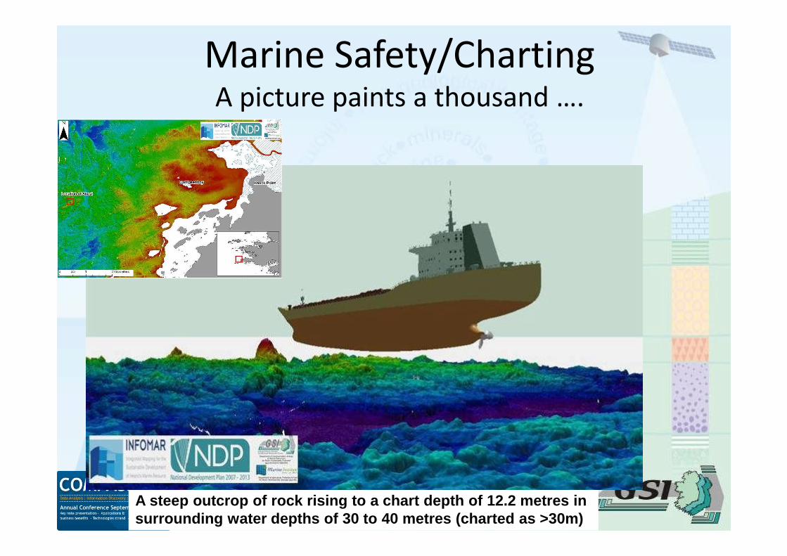
Marine Safety/ChartingA picture paints a thousand ….
A steep outcrop of rock rising to a chart depth of 12.2 metres insurrounding water depths of 30 to 40 metres (charted as >30m)

3D Merged DTMs onshore/offshore

Free Data?
• €100k sales revenue v €1.5m Project revenue
• 250 V 2,500 customers
• CBA on INFOMAR 4-6: 1 (with free data)
• Removes “pay barrier” (excuse for best practice)
• US Model/EC recommendation
• Precedent
• Moral high ground

Future IT Challenges (DCENR)
• Cloud / Virtualisation
reduce costs, space and energy. Productivity gains-high availability and riskmitigation to business operations. But heavy data users need >bandwidth
• HTML.5
Identify applicable services which can utilise HTML5 to meet converged webstandards and interactivity
• IPv6
Align with IPv6 adoption as the next generation protocol for the internet tosupport internet growth and security
• Big Data
Invest in up-to-date database management systems and data analysis toolswith Oracle 11g and SQL Server 2010 to capture and store data in a robustand retrievable manner (& always more storage & back ups!)
GSI Data Challenges
• Ease of consumption V visibility/origin
• Quality Control V Demand for data now
• Standards/data management V ease ofcreation/distribution – still RIRO
• GIS “only a tool” V Expert data managementskills
• N.B. Getting & retaining good IM-GIS people
Next?
• Mobile apps – BGS/ESRI (arcgis.com)
• Subsurface modelling > detail
• 3D > Visualisation to interp
• 4D modelling – Groundwater/Erosion
• 3D web
• > use of gaming technology/physics engines
• > convergence & integration

Better Planning Tools
Marine/Foreshore (MI)

New Generation viewers
3D Web – Landslide Viewer/Render Tool
1:500,000 Bedrock Geology
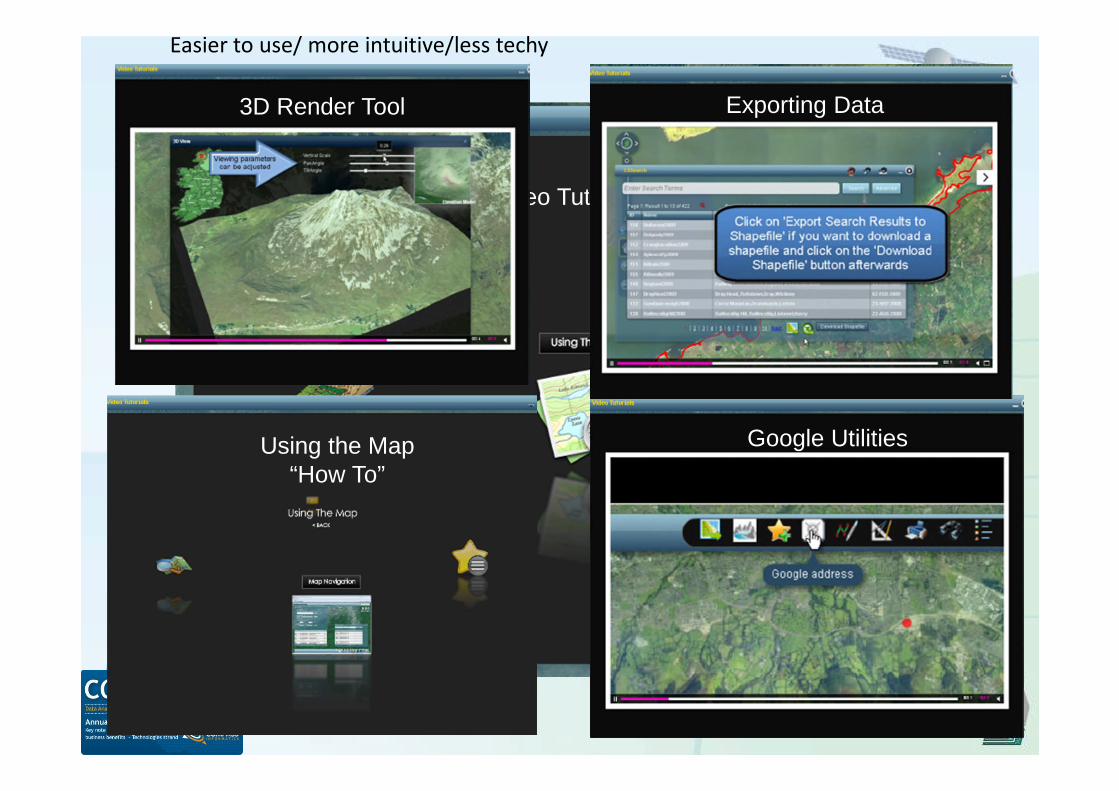
Video Tutorials Tool
Google Utilities
Exporting Data3D Render Tool
Using the Map“How To”
Easier to use/ more intuitive/less techy

Physics Engines/Gaming technologies
Seabed mapping+
Adjustable Turbine properties+
Adjustable weather=
Virtual Test site
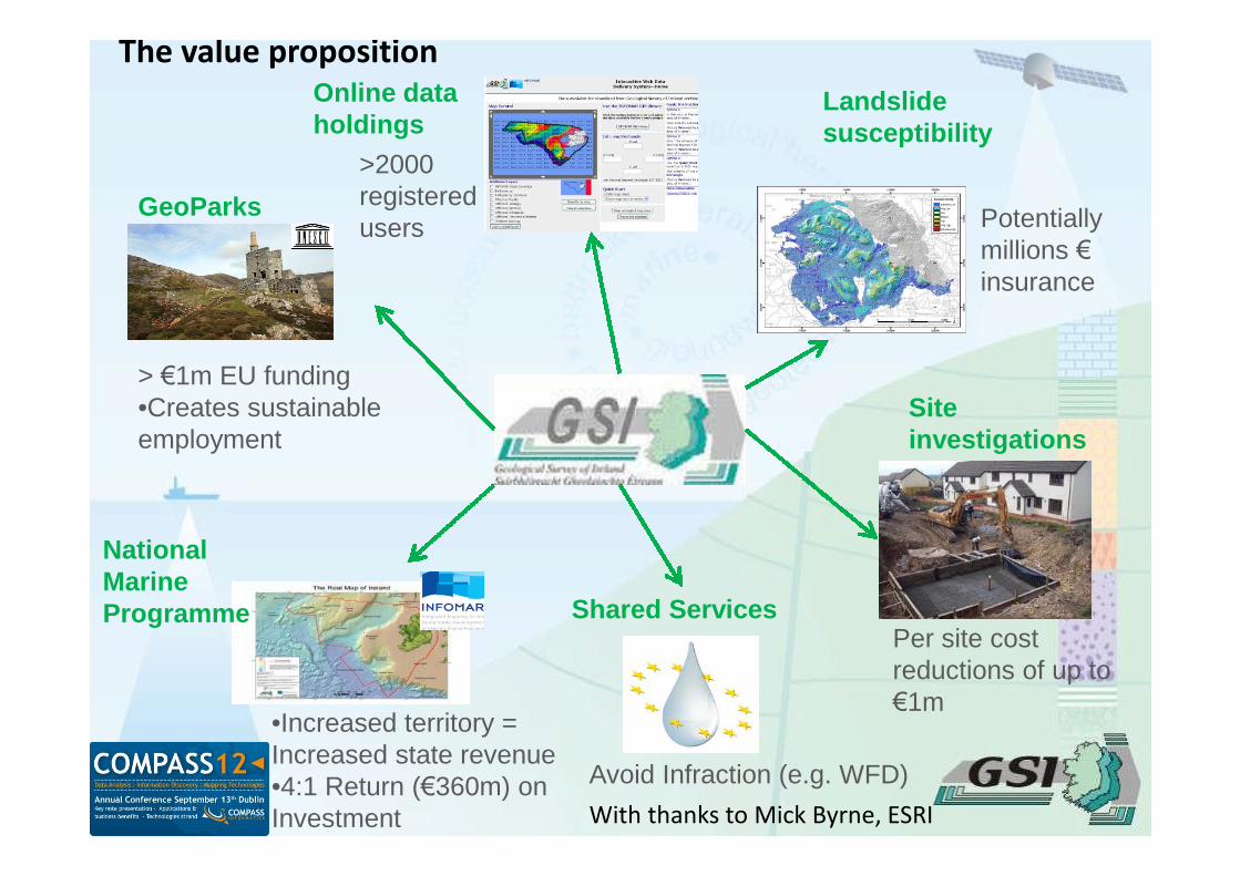
•Increased territory =Increased state revenue•4:1 Return (€360m) onInvestment
NationalMarineProgramme Shared Services
Avoid Infraction (e.g. WFD)
Siteinvestigations
Per site costreductions of up to€1m
GeoParks
> €1m EU funding•Creates sustainableemployment
Landslidesusceptibility
Potentiallymillions €insurance
>2000registeredusers
Online dataholdings
With thanks to Mick Byrne, ESRI
The value proposition