geological survey - usgs comparison of the areas within the first moraine ..... 30 the regions...
TRANSCRIPT

DEPARTMENT OF THE INTEKIOB
BULLETIN
OK THE
UNITED STATES
GEOLOGICAL SURVEY
No. 144
WASHINGTONGOVERNMENT PRINTING OFFICE
' 1896


UNITED STATES GEOLOGICAL SUEYEY
CHARLES D. WALCOTT, DIRECTOR
THE
MORAINES OF THE MISSOURI COTEAU
AND
THEIR ATTENDANT DEPOSITS
BY
JAMES EDWARD TODD
WASHINGTONGOVERNMENT PRINTING OFFICE
1896

CONTENTS.
Page."Letter of transmittal...........................-..--.-......._..........-.-. 9Introduction................................................................ 11CUAPTEH I. The Firsf, Outer, or Altamont moraine, with its attendant deposits. 13
General course of the moraine........................................... 13Detailed description of the moraine ..................................... 15
The Long Lake loop................................................. 15The Blue Lake loop................................................. 16The Antelope Valley loop............................................ 18The Koto Hills...................................................... 20The Blue Blanket loop......... ...........................f ......... 21The Bowdle Hills................................................... 24The Ree Valley loop................................................. 25The Ree Hills....................................................... 27The Boxelder loop .................................................. 28
The deposits connected with the Outer moraine.......................... 30A comparison of the areas within the First moraine ................. 30The regions outside the moraine..................................... 31
CHAPTER II. The Second or Gary moraine, with its deposits.................. 33General location of the moraine......................................... 33Detailed description of the moraine..................................... 34
The Blue Lake loop................................................. 34The Antelope Valley loop............................................ 35The Blue Blanket loop.............................................. 36The Bowdle Hills................................................... 36The Faulkton Hills or Bald Mountains............................... . 37The Ree Valley loop................................................. 38The Boxelder loop .................................................. 38
The region inside the Second moraine ................................... 39The drainage of the First and Second moraines.......................... 41
CHAPTER III. The Third and later moraines................................. 45The Third moraine...................................................... 45
Course of the moraine .............................................. 45Further description................................................. 46
Morainic formations hetween the Third and Fourth moraines............ 47The Fourth moraine..................................................... 48The drainage of the Fourth moraine..................................... 50
CHAPTER IV. Further notes and inferences.................................. 52Lake Dakota............................................................ 52Drumlins............................................................... 53Osars................................................................... 53Strise................................................................... 54Character of howlders .:................................................ 54Ancient soils............................................................ 55Older rocks............................................................. 55
The Fox Hills formation............................................. 55The Pierre formation................................. ............... 56
Pre-Glacial topography................................................... 57Pre-Glacial drainage .................................................... 57Testimony of wells...................................................... 58Lists of elevations...................................................... 61
5


ILLUSTRATIONS.
Page.PLATE I. Map of glacial phenomena in parts of North and South Dakota .... 14
II. Coteau scenery..............---- -..- . ---- ---- -- --- - - 16III. View east of Napoleon ............................................ 18IV. Beaver Lake and gap.............................................. 20V. Gravel tables ..................................................... 22
VI. Outer moraine southeast of Bangor................................ 24VII. Snake Ridge...................................................... 26
VIII. Medicine Hill..................................................... 28I.. Drift-veneered hill from the west.................................. 30X. Drift-veneered hill from the north................................. 32
XI. Ancient channel south of Swan Creek............................. 34XII. Ancient channel northwest of Leola............................... 36
XIII. Osars northwest of Edgely from the south......................... 38XIV. Osars northwest of Edgely from the east.......................... 40XV. Osar north of Bowdle............................................. 42
( Terraces near Le Beau........................................... 44( Spring Lake outlet.............................................. 44
XVII. Bowldery knolls northwest of Swan Lake ......................... 46XVIII. Bowldery terraces on Little Cheyenne............................. 48
XIX. Terraces at Pierre................................................. 50XX. View from the summit of Gravelly Knob, near Canning ............ 52
T ( The Fourth moraine southeast of Sanborn........................ 54\ The Okiodan Hills............................................... 54
FIG. 1. Section west of Medina ........................................... 392. Section east of Medina...............................:............ 403. Sections west of Cleveland........................................ 40
7


LETTER OF TRANSMITTAL,
UNITED STATES GEOLOGICAL SURVEY,GLACIAL DIVISION,
Madison, Wis., December 9,1891.Sm: I have the honor to transmit herewith the manuscript of a
report upon "Tne moraines of the Missouri coteau and their attendant deposits," by Prof. James E. Todd, of this division. The report con tains a large amount of valuable data relating to a region relatively little known.
Very respectfully, yours,T. 0. CHAMBERLIN,
Geologist in Charge. The DIRECTOR UNITED STATES GEOLOGICAL SURVEY.
9


INTRODUCTION.
It seems important that several general facts should be stated for the full understanding of terms used and allusions made in this report. The field considered is the region lying between the Missouri and James rivers, and between the latitudes of Jamestown, N. Dak., and Huron, S. Dak.
1. As has been stated in papers published by Chamberlin, Upham, myself, and others, several more or less distinct moraines have been observed in the Mississippi Valley. It has been found convenient to distinguish the outermost three by special names. President Cham berlin has named them, beginning with the outermost, Altamont, Gary, and Antelope moraines, from localities south of Big Stone Lake, and these names have been quite generally adopted. Upham and others have named them the First, Second, and Third, and as the outermost two are the more prominent, they have also been called the Outer and Inner moraines. Each of these, especially the First and Second, has subordinate divisions, which mark the borders of the different lobes into which the margin of the ice sheet was often divided.
2. It is assumed that the reader is familiar with the generally rec ognized features of drift formations, such as the undulating topography and the series of drift deposits, covering an area with successive layers of till in a manner which might be compared to a nest of spoons of assorted sizes, the smaller lying inside the larger. Of these spoon- shaped deposits, the moraines form the outer rims.
3. As the moraines are the most conspicuous features of the drift formations, we may take them as the basis for dividing the subject. Not only are they the most conspicuous features of the topography, but they mark culminations of glacial activity. We therefore propose reviewing our subject under the following heads:
I. The First moraine'and its attendant deposits.II. The Second moraine and its deposits.III. The Third and succeeding moraines.IV. General notes and inferences.This seems to be the fitting place, also, in which to acknowledge
several important favors received by me while I have been engaged in the work. The Chicago, Milwaukee and St. Paul Railway Company has not only furnished me much free transportation, but its chief engineer has furnished me elevations along its lines whenever requested. Simi lar favors have been shown me by Mr. A. Anderson, chief engineer of the Northern Pacific Railroad, and by Mr. W. W. Rich, chief engineer of the Minneapolis, St. Paul and Sault Ste. Marie Railway Company.
ll


THE MORAINES OF THE MISSOURI COTEAU AND THEIR ATTENDANT DEPOSITS.
By J. E. TODD.
CHAPTER I.
THE FIRST, OUTER, OR ALTAMONT MORAINE, WITH ITS ATTENDANT DEPOSITS.
GENERAL COURSE OF THE MORAINE.
The general course of the moraine may be indicated as follows:It crosses the Northern Pacific Eailr-oad between Sterling and Dris-
coll stations, in the eastern part of Burleigh County; thence it extends eastward to a point south of Geneva Station, then forms a loop extend ing toward the west-southwest, crossing Long Lake and circling into the northeastern corner of Emmons County; thence it runs in a north easterly direction to a point about 9 miles south of Tappen Station. This, for convenience, we shall call the Long Lake loop.
Thence the moraine takes a southerly course, gradually circling toward the east, to a point a little east of the center of the north line of Mclntosh County, forming a curve of less convexity than usual. At the latter point the moraine seems to turn sharply toward the northeast and finally northward nearly to the northeast corner of Logan County. This we have called the Blue Lake loop^ naming it from a small lake situated near the center of the' terminal portion,.in T. 134 JS"., E. 70 W.
From the northeast corner of Logan County the moraine returns to nearly the center of the north line of Mclntosh County, forming a very- long and a complicated interlobular portion. It then continues in a southeasterly direction to the southeast corner of T. 131 N., E 69 W., Where another slender interlobular portion extends toward the north east for several miles; thence it extends directly east to the east side of Mclntosh County; thence east-southeast into the'southwest corner of T. 130 N.,- E. 65 W. This portion we have called the Antelope Yal- ley loop.
Fr&in the last-named point the moraine extends along the crest of the table-land, 400 to 600 fe'et in height above the plain, east, in a direct south-south westerly direction, nearly to the southwest corner of T. 127
13
14 MORAINES OF THE MISSOUEI COTEAU. [BULL. 144.
N., E. 68 W., in the east-central portion of McPherson County. This conspicuous portion I have named the Koto Hills, a name derived from a town in that vicinity, thus also using the name which, with different spelling, is applied to the whole plateau region. Thence the moraine turns sharply toward the west-northwest, becoming gradually less conspicuous nearly to the north corner of McPherson County. From the northern portion of T. 128 1ST., E. 71 W., a sharp loop is thrown out toward the north nearly to the northwest corner of T. 129 N., E. 70 W. The moraine extends then nearly westward and soon northwest to the middle of the west line of Mclntosh County and thence southwest to the northwestern corner of Campbell County. It is quite feebly devel oped in its course through Emmons County. In T. 12,7 E"., E. 77 W., about 12 miles southeast of Lagrace, the moraine is again conspicu ously developed and extends westward and then southeastward, form ing a small loop ending in a very conspicuous promontory looking toward the east near the southwest corner of T. 126 K, E. 77 W.; thence it extends southwest and south along the east bank of the Missouri to the vicinity of Scranton, in the southwestern corner of Walworth County. Here again the moraine is only feebly developed, but arises again into prominence south of Bangor and holds a northeast direction from Swan Creek nearly to the northeast corner of Walworth County. This extended portion we have called the Blue Blanket loop, from the stream which drains the terminal part of the area inclosed by it.
| ; From the southern portion of T. 124 JST., E. 74 W., in the northeast corner of Walworth County, the moraine sweeps east-southeast, then south:southwest, forming a broad interlobular or reversed loop to the southwest corner of Edmunds County, thence south and east of south into the northwest corner of T. 118 N., E. 77 W., about 15 miles east of Gettysburg. This portion we have called the Bowdle Hills, from the town situated in the northern portion of this reversed loop,
i From the prominent portion of the moraine east of Gettysburg it turns again very sharply to the west, forming a slightly convex curve around north of Gettysburg to the vicinity of Forest City, on the Missouri. -Thence it follows along the east bank of the Missouri Eiver, forming a quite regular curve to the vicinity of Pierre, thence east- northeast to Medicine Knoll, 3 or 4 miles southwest of Blunt. This we have called the Eee Valley loop.
From the vicinity of Blunt the moraine turns sharply southward along the east bank of Medicine Creek nearly to the Missouri, when it returns toward the northrformiug a small loop; thence in a nearly due easterly direction through the one hundred and eleventh tier of town-; ships to the west side of Hand County, where it becomes more promi nent and is sharply turned upon itself, forming an interlobular portion locally called the Eee Hills. We would extend the name Eee Hills to include all of this portion just described. From the interlobular por tion south of Eee Heights in western Hand County, the moraine turns

US.GEOLOGICAL SURVEY BULLETIN N° 144. PL.l
- X-^-i.!Lj-?*II5 tSJ**aJ^jM£iZ° j«? ,_6e ^
GLACIAL PHENOMENAIN PARTS OF
XORTHAND SOUTH DAKOTABY
J.E.TODD1891.
Lake Dakota.Ba.siu
Higtier BowldeiyTerraces-fiChanitels ' ;
Margin of the Drift ijjilli Lower Bowldery Terraces ft Channels 1 2 3 & 4- indicate the different moraines in the order of their formation:.
JULIUS B!E M a C

THE LONG LAKE LOOP. 15
sharply to the southwest along the east bank of Boxelder Creek nearly to the southwest corner of Hand County, thence southeast to the vicinity of Gann Yalley, T. 107 1ST., E. 68 W., in the southeastern part of Buffalo County, thence a short distance northeast, then curving northwest and east with a somewhat complex structure into the south eastern corner of Hand County, thence south nearly to Crow Lake in T. 106 N., B. 66 W., thence with a sharp curve to the prominent head land, Turtle Point, near Wessington Springs. From this point the course of the moraine has been described in a previous paper.
DETAILED'DESCRIPTION OF THE OUTER MORAINE.
THE LONG LAKE LOOP.
The portion of Long Lake loop which falls within our field is little more than its southern half. The drift comprising this loop is more sandy than that of portions of Dakota farther south, for the reason that it lies for the most part in a region underlain by the Fox Hills sandstone. Along its axis extends the deep, straight valley of Long Lake, with its associated lakes. This valley is from 150 to 225 feet lower than the crest of the moraine at the south, the moraine being higher toward the east and diminishing gradually in height toward the west. The inner slope of this southern portion of the loop is occupied with numerous morainic lakes, their longer axes being usually parallel with the axis of the valley. A more careful examination shows two or three slight curves in this southern half. North of Long Lake, between it and the Northern Pacific Bailroad, lies a sharp and conspic uous interlobular moraine with traces of knobs and stony hills extend ing as far east as Steel, although it is traversed south of Geneva by a line of depressed lakes extending in a southwesterly direction. About a mile and a half west of Driscoll lies the inner part of the moraine, and passing obliquely across the moraine in a southwesterly direction there is a valley, including a chain of lakes, which opens to the south west into a branch of Apple Creek. West of this gap the hills rise again in a narrow ridge north of Sterling and extend north and north east; how far was not observed. The presence of the Fox Hills sand stone is shown by the capping of a butte encircled by Long Lake, just outside of the moraine j also by the conspicuous outcroppings along Sand Creek, a stream flowing into the lake from the south, and about the borders of the table-land southwest. The same formation is simi larly developed along Long Lake Creek, which, rising near Long Lake, flows southwest in a large valley to the Missouri Eiver near old Fort Eice.
The moraine south of Long Lake broadens toward the east and increases in height, gradually reaching its culmination south of Daw- son. It is traversed by three or four imperfect gaps, crooked, aiid not cutting deeply into the mass of the moraine.

16 MORAINES OF THE MISSOURI COTEAU. [BULL. 144.
The interlobular portion gradually decreases in height toward the northeast, but renders the land undesirable to settlers as far as the center of T. 138 N., E. 71 W. The northern side is more abrupt and rises higher above the inner plain. This interlobe lay between two lobes of ice differing considerably in character. The one upon the north moved more rapidly and in a somewhat deeper valley with less obstruc tion and freer drainage. The one on the east moved upon a rougher and higher plain and was nearer the end of its course, and the drainage was considerably less free. The portion of the moraine formed by the eastern lobe is wider and presents a more confused topography. Little of the material brought forward by the ice was washed away.
Traces of the internal drainage system have been but incompletely noted, but one channel, several rods in width and quite distinct, is occupied by the road from Napoleon to Dawson for 8 or 10 miles. It has not the pronounced character of such channels where the water from the Second moraine has also discharged through them. It shows little trace of terraces and is shallow and not very constant in width or depth. A view of the topography, which is quite typical of the moraine as it is generally developed upon the Missouri Coteau, is shown in PI. II.
THE BLUE LAKE LOOP.
In the Blue Lake loop the moraine has its grandest development. It is really so rough and broad that it presents a formidable barrier to travel. Its slopes are so' steep that wagons are frequently in danger of being upset; it is very stony in some places and marshy in others, and in the region it occupies it is very difficult to keep one's direction, because the view is limited most of the time and there are no reliable landmarks. In fact, there is danger that one conspicuous knob may insidiously substitute itself for another which has been relied upon for guidance, and thus lead the traveler far out of his way. The breadth of the moraine is from 6 to 10 miles. There are few, if any, ancient channels which might serve as passes clear through the moraine on its whole west'ern or front side except the imposing channel leading from Blue Lake to Red Lake. There are several which traverse part of the distance, that is, they pass through one of the principal divisions of the moraine. Some of them evidently turned toward the ice as soon as it began to recede from the inside of the moraine. There is rarely trace of distinct ridges in this mass of nills and basins. (See PI. I.) Its southern portion, in the southern half of Logan County, is separated into two tolerably distinct systems with comparatively level land between. The outer of these is considerably broader than the inner. Blue Lake is one of the largest of several occupying this intermediate portion of the loop.
The moraine maintains a height of from 2,000 to 2,075 feet above the sea throughout the whole of the western or outer portion of the loop. It rises about 200 feet above a nearly level plain several miles in width,

U. S. GEOLOGICAL SURVEY BULLETIN NO. 14* PL.
COTEAU SCENERY.
View ENE, from a high knob near the center of sec. 4, T, 1 76, R, 72.
^-, Plain inside the First moraine, about Lake Edwards.

TODD.) THE BLUE LAKE LOOP. 17
which separates it from the Second moraine. The region outside rises to about the same height as the moraine itself, some points attaining a greater altitude. Along the outer face of the moraine is a very notice able line of large bowlders, reminding one of a sand ridge along high- water mark on the seashore. Along the inside of this line the bowlders gradually decrease in size; outside they disappear more abruptly from the surface. How far this character descends into the drift below has not been determined. This line is shown in PL III.
North of Bed or Beaver Lake the drainage of the inside of the moraine is, and evidently was during the occupation of the moraine, into the east branch of Sand Creek. Two of the more prominent val leys converge and meet at Berry Lake, west of Napoleon. A terrace of gravel and sand fills the lower part of these valleys to a height of about 25 feet above the lake. Traces of this terrace are found along the valley running west, which has steep sides and is about 36 feet below the general level where it leaves the lake, and 130 feet below that level in the vicinity of Merriam, sec. 27, T, 136 N., E. 75 W. The steepness of the sides of this valley is due to the presence of layers of sandstone of the Fox Hills formation. The fineness of the material and the shallowness of the valley suggest that either there was little water running or that the baselevel of erosion was high during the occupation of the moraine, or possibly that the terraces were really formed subsequent to the ice occupation. The main drainage, however, of the Blue Lake loop, and also that of the Antelope loop, found its way west through the highland by Beaver Lake gap, a sketch of which is given in PI. IV.
The southeast side of the Blue Lake loop forms part of a very long interlobe occupying the southeastern corner of Logan County and reaching about 30 miles, nearly to the northeastern corner of the county. It is not so broadly developed as the western side of the loop. It shows .more low areas and valleys, seemingly portions of old waterways, and the hills tend more to a clustered arrangement. This is especially true of the inner member.
The interlobe formed by this portion of the Blue Lake loop and the northwest side of the Antelope Valley loop extends from a little north east of Green Lake, northeast and north-northeastj to the middle of the eastern line of Logan County, then nearly north to its termination near the northeast corner of the county, as alceady stated. The northern half is 4 to 5 miles wide, and is high, and rather compactly developed. Its northern end lies near the eastern edge of the plateau and stands high enough to be conspicuous 25 to 30 miles away. Its internal drain age has not been explored. Around its northern end and several miles down its eastern side there circles a continuous chain of lakes and lake beds lying between it and the Second moraine, which were formed, no doubt, by the drainage contemporaneous with the latter. More has been learned of the drainage of the southern half of the interlobe.
Bull. 144 2

18 MORAINES OF THE MISSOURI COTEAU. [BULL. 144.
Three or four drainage channels, beginning with as many rather large lakes on the inner side of the outer member of the Outer moraine in T. 133 K, E. 69 W., and 133 N., E. 68 W., seem to be concentrated near the middle of the north line of T. 132 N., E. 69 W., in the one large, deeply eroded channel which runs directly from that point to Green Lake. This channel has in places somewhat precipitous sides, and its width is estimated at 300 to 400 yards. A nearly continuous chain of narrow lakes occupies its whole length. There are portions of a bowldery terrace along the sides of the channel, 40 to 50 feet above its bottom and at about the same level as a high delta just at the debouchure of the channel from the front of the moraine near Green Lake. Traversing it to the right of the main channel, there are two channels flowing more directly northeast into the valley. Green Lake seems to be really the lower portion of this same channel a little to the east of its junction with the south branch of Beaver Creek.
THE ANTELOPE VALLEY LOOP.
This loop resembles, in its main features, the loop just described. It lies upon the plateau in a somewhat similar position. It is very broad and massive, especially in the eastern portion of its southern side. It may be briefly described as the counterpart of the Blue Lake loop. Each may be. compared to a rudely drawn capital letter L with its hori zontal portion slightly curved. The vertical part of the L would form the interlobe just described and the horizontal part would correspond to the portion of each loop which lies facing the region outside the moraine. A further parallel may be stated thus: The distal half of the horizontal part of each is massively developed and lies near the margin of the plateau, one on the north, the other on the .east, while the proximal half is separable in each case into two ranges of hills. This has already been stated of the Blue Lake region, and seems a probable interpretation of the facts in this area. The correctness of, this may be better judged after presentation of facts.
Along the southeastern side of the Green Lake outlet lies a narrow ridge not more than a mile in width. Along its eastern side are numer ous lake beds and two or three narrow gaps cut through it to the main channel. From the southeastern corner of T. 132 N., E. 70 W., a high, massive ridge 4 or 5 miles wide extends east-southeast into the southwestern corner of T. 131 N., E. 68 W., from which point a system of morainic hills extends northeastward to the middle of the north lineof T. 132 N., E. 67 W., near the northeastern corner of Mclntosh County, where it joins an extension of the interlobe from the north. This system of hills is probably equivalent to the inner member of the moraine, but possibly may be interpreted to be an interlobular exten sion from that moraine. Along its western side is a broad, eroded valley with numerous lakes bearing evidence of much drainage toward the southwest, and suggesting a gap in the moraine in that direction j but

U. S. GEOLOGICAL SURVEY BULLETIN NO. 144 PL. Ill
"dMtMfaftf -w*--
^
if^^ - < ^'^^7^-^' . i.^^i?^>..^^^B^-'_i-^-^^^^^ s * ".-^5i-.as&^i^^:>^^
.(¥ i^.^/?^o. -<rn
^.;f^>'-V^^ v^, l ". ^<;:: y, /-,/"« /^
' ^ ^ f- fe *-_.-_ I'-vVV
VIEV/ EAST OF NAPOLEON.
Looking S. 34° E. (magnetic), from near northeast corner of sec. 25, T. 1 35, R. 72.
-*-, Outer slope of First moraine; -* -v, Valley connecting Green and Red lakes; ^--.- v, Beaver Creek Valley.

TODD.] THE ANTELOPE VALLEY LOOP. 19
no such gap was observed, though the moraine there was not as care fully examined as would be necessary to decide the point. A small system of lakes, less deeply eroded, lies along its southeastern side, which leads to a prominent gap or ancient outlet through the outer member of the moraine near the middle of .the south line of T. 131 N., E. 68 W. This will be called Eussian gap. From this outlet a moraine similar in height and width to that described just west of the gap extends due east to the northeastern corner of T. 130 N., B. 67 W., where there is another drainage channel, which will be named Butch gap, extending in a southwesterly direction. Northeast of this gap another system of hills extends northward into the southeastern corner of T. 132 -N., E. 66 W. Along these hills are many depressed lakes and chan nels, and from the northern end a line of lakes extends in a northeast erly direction to the northeastern corner of the same township. The southern end of this system of hills joins the hills which we shall describe under our next head as the Koto Hills. East of Dutch gap the system presents very high morainic hills separated by low valleys leading to the southwest. In this way the moraine extends to the east front of the plateau on the north line of T. 129 K, E. 66 W., the south western township of Dickey County. Here it becomes closely identi fied with the Second moraine. This whole south side of the Antelope Valley loop is broad, massive, and high, rivaling in all features the corresponding parts of the Blue Lake loop. Its highest altitude has not been accurately determined, but may be safely put down as between 2,100 and 2,150 feet, 500 to 600 feet higher than the plain east of the Coteau, 100 to 125 feet above the plains inside of the moraine, and a little more above the general level of the plain outside to the southwest.
The nature of the region outside deserves special mention. Next the moraine which we have been describing is a system of similar hills, i. e., presenting bowldery knobs and basins, but differing markedly by their low and nearly uniform altitudes. Seen from a distance they have the appearance of a terrace about 100 feet lower than the summit of the moraine and a trifle higher than the smoother plain southwest. The basins seem irregular excavations in the body of the terrace 25 or 40 feet deep, and are often channel-like. The channels are more confluent and the lakes larger toward the southwest. This region is 3 or 4 miles wide opposite the Eussian outlet and wider farther west. These terrace hills extend from Green Lake outlet along the whole front of the moraine to the east line of Mclntosh County. The material of the plain becomes finer as one recedes from the moraine, and about Ashley there is a very level plain about 6 miles square, covered with loess-like silt, and upon the surface there are no pebbles. From the wells near Hoskins, in the south part of T. 130 K., E. 70 W., it is learned that the silt is about 40 feet in depth, and is underlain with bowldery drift which is exposed along the shores of the large lakes that lie in the plain at about the same level.

20 MOKAINES OF THE MISSOURI COTEAU. [nuii.144.
THE KOTO HILLS.
From near Aberdeen or at Bllendale the traveler's attention is attracted to a high, massive ridge lying along the northwestern hori zon. He is told that it is the " West Coteau." Its imposing appearance, with its stony character for the first few miles which were commonly traversed by visitors, and the reports of strange alkili lake basins with out vegetation, gave it in early times a singular interest. Eumors of gold and " mineral" were associated with the numerous deep ravines which furrow its eastern front, but none of these have yet proved true. The most valuable products yet found are the springs of fine water, the groves of thrifty trees in the glens, and the nutritious grasses which grow on the stony hills and broad slopes.
From a distance it may be noticed that there Is an abrupt drop in the summit of the plateau a little north of west from Ellendale, near the northeastern corner of T. 129 IS"., E. 66 W., and another a little south of west of Koto, in the southwestern corner of T. 127 N., E. 68 W., and the highland extends outside these limits at a lower level. The Koto Hills lie within these limits and comprise both the First and the Second moraines. They may be described as a high, massive, continuous ridge, about 18 miles long and 6 miles wide, running nearly straight in a north-northeast to south-southwest direction, with its lower portions about 500 feet above the plain to the east and 130 feet above the gen eral level of the plain to the west. This ridge is studded iu an irregu lar manner with knobs 25 to 50 feet in height, interspersed with ponds and lake beds. The hills are separable, more or less distinctly, into two systems, the lower and less prominently developed occupying the eastern edge, and the other the western half of the narrow plateau or ridge. Those on the western half are clustered into three or four quite prominent knots, somewhat elongated in the direction of the ridge. These systems are wider apart toward the south, and channels drain ing in that direction begin to separate them a little north of the south line of McPherson County. The whole eastern slope is seamed with ravines or gulches 15 to 50 feet deep. There is on the north end of the hills a shallow gap or old outlet with lakes running west-south west. This is about 100 feet lower than the general base of the hills farther south. The region west of the Hills resembles that before described on the outside of the Antelope Yalley loop, except that the hills are less regular in height.
An interesting and unique formation is found in the form of gravel- topped tables rising like islands in the drainage channels at the south end of the Koto Hills. One of these covers most of sec. 30, T. 127 U.j E. 68 W., and at least one other large one is found northwest and north- northwest from it 2 to 3 miles away. These lie with their tops flat and on the same level. The first mentioned was visited and its structure determined as far as possible without artificial excavations. The top

U. S. GEOLOGICAL SURVEY BULLETIN NO. 144 PL. IV
BEAVER LAKE AND GAP, FROM THE EAST.
The drainage channels from north and south, just outside the outer moraine, meet here and break through the highlands west, forming Beaver Creek.

TODD.] THE KOTO HILLS. 21
is capped everywhere with nearly pure gravel. There is a very gentle slope of the surface toward the northwest, and traces of narrow chan nels running in that direction were noticed in one or two places. The material is perceptibly coarser toward the southeast. Along the sides, which are quite abrupt, burrows show that fine sand extends from within about 15 feet of the top downward indefinitely. The change from gravel to sand seems to be very abrupt. These tables appear to be detached fragments of an old gravel plain extending toward the northwest. The one most fully examined lies about. 90 feet above the lower basins near by, which are the deeper courses in the reticu lated system of channels running southwest into the head of Spring Biver. PI. V gives a general view of the appearance of these plains. These seem to have been formed either by a broad interlobular drainage channel to the northwest, when the ice was at its maximum occupation of the First moraine, or perhaps, in open spaces in the ice. The fine sand forming their main bulk is a puzzle which we do not profess to solve at present. The depth of erosion of the later channels may be explained by the ease with which sand may be removed. That it was not eroded by the currents which deposited the gravel points to the conclusion that at that time the base level of erosion was very high. From the profile of the railroad which runs at the foot of this table its top is estimated to be 2,025 feet above the sea. By th.e profiles of the same road the level of the silt-covered plain near Ashley is about. 2,010 feet. Whether this is to be explained by similarity of origin remains to be discovered.
THE BLUE BLANKET LOOP.
This is the most extensive division of the moraine of which this paper will treat. It is about 130 miles in length. It is remarkable for its great westward extension, for the northward and northwestward movement by which it was formed in some places, for the weak and scattered development of its northern side, and for the wide gaps which appear at its southwestern and northwestern corners, so to speak. It readily divides itself into its north side, its west side, and its south side, the before-mentioned gaps forming the divisions between these portions.
The north side begins in the vicinity of the gravel tables, one of the marked features being a high, broad, massive knot west-southwest of the tables, encircled by the east branch of Spring Kiver. This stream is nothing but a dry, depressed channel, with a gravel terrace and broad lakes, and with a tendency to a doubling of the channel, which is not uncommon in glacial streams laden with de"bris. From this point it trends nearly due northwest to the northern line of McPherson County, where it turns west and soon after divides into two members more dis tinctly than before. The outer forms a semicircle convex to the north, and, reaching nearly to the north line of T. 129 N., E. 70 W., it returns

22 MORAINES OF THE MISSOURI COTEAU. [BULL. 144.
and drains the inner member, which has kept a nearly west irregular course near the south line of McPherson County. It is perceptibly but stragglingly developed as far as the southwestern corner of Mcln- tosh County. The whole of this side of the loop is a much less marked feature than any portion of the moraine which we have yet considered. It rises in its eastern portion sometimes to the height of 100 feet above the plain on the outside, but south of Hoskins no points rise higher than 60 feet, and farther west it is still lower. It consists mainly of two or three small loops, pushed toward the north. The principal and most northern one is about 6 miles wide and occupies the southwestern township of Mclntosh County. Again, about 6 miles west of the south eastern corner of Emmons County it is quite prominent for a mile or two, but farther west it is little more than a law rounded swell with a few lake beds and bowlders.
The west side of the loop lies along the east bank of the Missouri, extending from Lagrace at the mouth of Spring Eiver to the vicinity of Lebeau at the mouth of Swan Creek. Spring Eiver, which flows nearly due west through the northern tier of townships in Campbell County, gradually deepens its channel, dropping lower and lower below the main bowldery terrace, which itself also declines toward the west till at Lagrace it is 80 feet below it. Lagrace may have been named from the beautiful scenery which surrounds the town. In this -picturesque topography the buttes form prominent features. These buttes owe their form .to a few layers of sandstone, probably of the Fox Hills formation. The level of the top of the sandstone is about 310 feet above the Missouri Eiver. The most conspicuous butte is north of the town occupying sec. 15, T. 128 K., E. 79 W. It stands as an island" separated from .the table-land north by an ancient channel of Spring Eiver,; ^hich runs through to the Missouri. About 4 miles, south of Lagrace another butte or promontory shows the sandstone and the capping with 10 to 50 feet of drift. This begins the ridge which rises gradually toward the south and soon puts on the topog raphy of a comparatively even moraine, basins and knolls appearing, but of a, subdued character. Toward the east the pre-Glacial surface seems to have been lower and the drift is consequently deeper.
The eastern slope of this ridge may be outlined as follows: From the before-mentioned headland south of Lagrace south-southeast to sec. 19, T. 126 K, E. 77 W., about 96 miles west of Mound City, thence with a quite sharp bend toward the southwest nearly to the south western corner of T. 125 E"., E. 78 W. ; thence south to the Boise Cache or Blue Blanket Creek 5. thence south by east to Swan Creek. The highest point of this ridge, as far as has been observed, is west of Mound City, where the hills rise about 525 feet above the Missouri Eiver, or to the height of 1,900 feet above the sea. At this point there are two shallow drainage channels which seem to have discharged west ward into the point qf a broad, triangular area with its base extending

U. 6. GEOLOGICAL SURVEY BULLETIN NO. 144 PL. V
^y%^^fw^^m^ ^ -^^m^^^^^K--!'-'^^^'^.?--^v^^>j:^^r-;^*fe^^M,^^--- a^fe:'^ . *,' ''
.. yd'/,- -r<a%~.-^S . 0 j4*:X \ - ^- i" v?u- -; ^-<*»i?U-V-.-^. - ^Sp^vi^- -^-=-- : -.^fe*.-'-- - '-, -
^^^^-^^ '"-' : --
GRAVEL TABLES NORTHWEST OF LEOLA.
Looking N. 42° W., from near southwest corner of sec. 30, T. 1 27, R. 68.
TODD.] THE BLUE BLANKET LOOP. 23
along the river for 8 or 9 miles. Apparently the water discharged at this point assisted greatly in eroding the pre-Glacial deposits, and so formed a broad, interlpbular drainage system which eroded down to a level 150 to 200 feet below the top of the moraine. There seems to have been other less important lines of dra'inage converging to the same triangular area. A much more important outlet, however, was at the present passage of Blue Blanket Creek through the moraine. Along the east foot of this ridge, which we consider the outer member of the First moraine, and somewhat separated from it, rises a range of foothills extending north and south, which may be considered as a feebly developed inner member of this moraine. This includes a cluster of hills covering three or four sections in the eastern half of T. 127 N., E. 76 W., and a narrow, even ridge running south through T. 126 N., E. 76 W., about 1 mile west of Mound City, and continuing in the same direction to the middle of the next township, where it curves west arid breaks up into detached hills, which show the effect of much water flowing toward the southwest. This moraine rises about 60 feet above the bottom of the valley just east. This valley is remark able for extending from Spring Eiver, .18 miles south, to the Blue Blanket at about the same level, viz, about 150 feet above the Missouri. Among the early settlers its indeterminate drainage won for it the name of the "Morphodite." Mound City obtains its name from, two or three low mounds of gravel, situated a short distance north of the town. These may be considered osars. The moraine south of Blue Blanket Creek shows still less morainic topography, .a fact which may be accounted for by two influences; one the effects of erosion, because of its vicinity to the Missouri, and the other the covering of the drift
"of that region with a loess-like silt.The south side of the loop may be described as follows: As has
been before stated, there is a gap of several miles along the lower course of Swan Creek, but in. the southern part of T. 122 1ST.. E. 76 W., morainic hills again unmistakably appear on the northern bank of Swan Creek, and, though narrow, they continue constantly widening and rising toward the northeast. No trace of the moraine has been found south and west of these, with the possible exception of a few morainic hills capping the bluffs south of Swan Creek in T. 121 N., E. 76 W. The whole region is so deeply eroded by ravines that the absence of the moraine may possibly be ascribed to its removal by erosion.
The range continuing northeast is 1 to 3 miles wide, and presents all the main features of a moraine. The increasing gentle declivity toward the northwest, the ragged crest, and the prominent outlets leave no doubt about the inoramic character of this ridge. A view of it is given in PI. YI. At the southAvestern corner of T. 124 N., E. 74 W., the northeast township of Walworth County, it rather abruptly takes an easterly course, which, with a slight curve to the south, it preserves

24 MORAINES OF THE MISSOURI COTEAU. [BULL. 144.
to a point 7 miles north of Bowdle, where it is joined again by the Second moraine.
This moraine toward the south rests against higher hills, which, from a few observations made along their southwestern side, and their general form and relation, are judged to be formed of Cretaceous clays. North east of Swan Lake the topography is erosive, and the clay hills have bowldery ridges lying in their valleys, though there is no drift to speak of upon their outer spurs. Just west of these hills a valley running south from the moraine joins Swan Creek a little below the west end of Swan Lake. It is fully lined, both on bottom and sides,- with numerous bowldery ridges lying parallel with the axis of the valley.
South of the northern half of the portion under consideration the outside of the moraine is much eroded, and in places is 125 to 150 feet lower than the crest of the moraine. Besides numerous smaller chan nels flowing into this area there are two very marked outlets or gaps. One of these we shall call Spring Lake outlet. It begins on sec. 20, T. 123 N., E. 75 W., and runs east into a marshy lake bed called Spring iake, which also received water from smaller gaps farther north. This gap is fully a half mile wide, and descends from the higher land north west to this lake.
Another gap, which we call Swan Creek outlet, is near the north eastern corner of the same township, and it is narrower and deeper, and forms the main source of the north branch of Swan Creek. The whole outer slope of the moraine is furrowed with ravines, and the region is unusually sandy and gravelly. As will be readily seen, the south side of this loop of the moraine forms the southwestern side of a very broad interlobe or reversed loop, of which the Bowdle Hills form the eastern side. The peaks of this portion of the moraine are 2,125 to 2,150 feet above the sea, or 125 to 150 feet above the lower channels outside, and 60 to 70 feet above the rather abruptly sloping plain to the north and west.
THE BOWDLE HILLS.
Here, as in the case of the Koto Hills, we have a combination of the First and Second moraines, which toward the north are- closely com mingled, but farther south are quite distinct, though coming together again toward the southern extremity. They begin 7 or 8 miles north of Bowdle, not being distinctly separable from the last portion consid ered, and, extending first to the southeast, curve to the south-southwest east of Bowdle. This direction is held by the First moraine to the south line of T. 120 N. } E. 74 W., where a prominent gap is found 9 miles east of Pembroke; thence the Outer moraine turns more to the east to the northwestern corner of Hyde County. This moraine resem bles, in general features, the portion last described. The land outside is lower than the plain east, and drainage is by numerous small chan nels, especially in its northern half. South of the Pembroke outlet the

U. S. GEOLOGICAL SURVEY BULLETIN NO. 144 PL. VI
OUTER MORAINE SOUTHEAST OF BANGOR.

TODD.] THE BOWDLE HILLS. 25'
moraine is more massive and higher. The width of the moraine is from 2.to 5 miles. Its development is especially imposing in the south eastern corner of Potter County. Along its west front a wide valley extends from near Bowdle to Copp, in the southeastern comer of Potter County. This valley is now drained in the northern half by the branches of Swan Creek, and the southern half by the principal branch of Okobojo Creek. The whole valley abounds in sand and gravel. West of this valley and south of Swan Lake are found hills rising higher than the moraine, composed mainly of Cretaceous clays; yet they are more or less covered with drift. The Pembroke outlet cuts down to the base of the moraine and is occupied by alkali lakes. Just east of it is a large fresh-water lake occupying nearly a whole section. The altitude of these hills is about 2,050 feet east of Bowdle and is estimated to be somewhat lower toward the south, but rises again to its former height at the south end.
The Second moraine leaves the First southeast of Bowdle, adopts a straggling character, extending nearly directly south to the southern line of Edmunds County, then becomes narrower and more distinct along the western line of Faulk County, and rejoins the First moraine near Cramer, close to the northern line of T. 118 N., K. 73 W.; thence it curves abruptly, but returns to the First moraine at the northwestern corner of Hand County.
THE REE VALLEY LOOP.
This portion of the moraine, like the Blue Blanket loop, is especially notable for its westward and northwestward extension and compara tively weak development. This loop marks the most westerly extension of the ice south of Bismarck. It consists of isolated clusters of knobs, in part, at least, composed of pre-Glacial rocks covered with several feet of stony drift. Its form was quite symmetrical, but the portions which remain seem to be mainly the parts «of short reentrant angles, along a crenate edge. These may be enumerated as follows: West of the high hills in eastern Potter County lies, as before stated, the broad, shallow valley of Okobojo Creek. West of this, in the southern part of T. 119 N., R. 75 W., hills presenting morainic features are found lying in an east-and-west direction. Then another gap occurs partly occu pied by a branch of Little Cheyenne Eiver; then a very conspicuous knot of bowldery knobs, the highest point being about 3 miles north of Gettysburg, with a lower development toward the west. West of Gettysburg, lower hills, presenting features of a moraine, stretch across the township, gradually decreasing in height to the western line. Faint suggestions of a moraine, in the form of bowldery hills upon the edge of the plain, were noticed about 3 miles south of.Appomattox. Again, elongated hills, rising 30 to 40 feet, were found lying in a north and south direction 3 to 4 miles south of Forest City. In the southwestern quarter of T. 116 N., R. 79 W., are the Artichoke Buttes, which are

26 MORAINES OF THE MISSOURI COTEAU. [BULL. 144.
a prominent feature, rising 25 to 30 feet above the plain. On sees. 12 and 13, T. 115 N., R. 80 W., is another north and south range, and again crossing section 31 of the same township. Two miles south lies the conspicuous cluster of hills known as Sully Buttes. From a point on the south side of Okobojo Creek and 3 or 4 miles southwest of Okobojo town, a low swell ridge begins and extends south and some what east to the southeastern corner of T. 112 ]$"., E. 80 W. One of the most notable fragments of a moraine is found in Snake Eidge, 4 miles north of Pierre, which runs in a' southeasterly direction. Its northwestern end overlooks the Missouri. A view of it is given in PL VII. Its outer slope drops abruptly to a high terrace of the Missouri about 250 or 300 feet above the river. Its northeastern slope declines less abruptly in that direction. Other hills are found in two or three sections in the center of T. Ill N., E. 78 W. There are also low hills, extending 3 or 4 miles east and west with a branch to the southwest, lying on the northwestern corner of T. Ill N., E. 77 W. The next and last representative of this loop is known as Medicine Knoll, which name is particularly applied to the northeastern and highest end of a massive ridge, ?1. VIII, beginning on sec. 25, T. 112 K, E. 76 W., and extending south-south west and southwest nearly to the Missouri. This Medicine Knoll descends abruptly to its east side into the valley of Medicine Creek, and the erosion of the Cretaceous clays has cut a deep valley around the northeastern end, producing a high, precipitous front rising for nearly 200 feet. The summit of this ridge is about 500 feet above the Missouri Eiver, or 1,900 feet above the sea. The plain northwest of this ridge descends gently in that direction. East of Medicine Creek, north of Blunt, hills somewhat higher than the gen eral level begin "and have the peculiar feature of gaps, from which streams pass from the northeast into Medicine Creek. This is looked upon as indicating morainic origin. These hills are regarded as the eastern half of a broad infer!obe, of which ancient Medicine Creek was the internal drainage channel.
Farther south, more particularly on sec. 28, T. Ill K, E. 76 Wv there begins a very high, bowldery ridge, which extends south 3 or 4 miles. The character of this ridge toward the south is somewhat problemat ical. Its even height and connection with the river suggest the edge of a high, bowldery terrace, and it is not easily interpreted to be a por tion of the moraine. A smaller ridge is found north of Forest City, extending northward 4 miles from the Little Cheyenne through the center of T. 119 N., E. 78 W. This also is looked upon as a remnant of a bowldery terrace or an example of drift-veneered- hills. If this is not its origin it remains unclassified, for it can scarcely be accounted for by any theory as a moraine of the older drift. While speaking of this region north of the Little Cheyenne, mention should be made of certain ancient channels traversing the region at high levels. One of these, a quarter of a mile in width, was found extending from the

U. S. GEOLOGICAL SURVEY BULLETIN NO. 144 PL. VII
- -' "4|£*V; ''''^ ''"f^"',"''' " ' -'-^^^^^^ .^~-- v/ '''''^3(^^:1^ V;'^V^^ ' *
'-, 7i<"i<,//'" "'M'-iM-Jit'/ f/ ' "* ",, ' ti -^_ ' - ' . ^~~^ ^ ."^'x .'^ A ^'i^.i^V.^V^/'^fc;*"»'^_ ' ^^ - - - .' ^^^-^. ' ^^\ ^ " - ^,./v v ^ ':- P '>^v..^,MV n'>>)^/f7^^_ , » ,;" -^ ^--^_''-o , . ,, , "^^!«-.,. . v/- ,. ,/ ,. ~*>>''**>vnj« UWM,, /, ,.,^.-_. ^^ ~_ -^~~- .^i'/-// ,'' /,""/-,/: u "-- "/.'. '^". ..,A^M^,r^?^ft^*^ ~~ - -._ ' _^
&/$|^'ft^^^^x,v,w%^w> .^ &''/1'' lW.f // '' l;>^''>i/iV> f/>y -^>/C/ --"«^v.^v;"- .;,' ^l^M'^>^.^^^^fc»li»: '/}/r'^^l^/K'W!P^f^^W//( ' u
v^&dWVfzW"*.$wmw:\$*''<'t\f^ 1̂'^1"' 1̂ '
SNAKE RIDGE.. The moia:ne ; -^ -v-, The high terrace ; -^-^^-, Trough of the Missouri River.

TODD.] THE REE HILLS. 27
valley of Swan Creek southeast across sec. 5, T. 120 IS"., E. 76 W., to a branch of Little Cheyenne. Its sides were studded with bowlders, which rose somewhat higher than the surrounding country and which by erosion in places were made to resemble hills or osars.
. The Eee Valley loop differs from most that we have considered, in that the region outside and within the moraine is on about the same level. This is particularly true to the west and south. The plain within this loop is considerably more even than in other loops that we have described. Its general altitude may be inferred from some pre liminary railroad surveys, which show that 8 miles south of Gettys burg it is 1,960 feet above the sea. Near the northeastern corner of T. 116 K, E. 78 W., it is 1,840 feet. Toward the south it is some what lower, being about 1,700 feet northwest of Blunt and about the same distance northeast of Pierre.
THE REE HILI.S.
East of the hills south of Blunt is a broad valley 4 or 5 miles wide. Beginning about 3 miles south of Blunt and rapidly deepening it extends to the main bowldery terrace of the Missouri, with which'it is continuous. Along the western side of this valley lies another terrace with the higher gravelly knolls along its western side. This is shown in PI. XX. The inner or eastern edge of the terrace is about 400 feet above the Missouri Eiver. Eising from the east side of this valley, near the north line of T. Ill JS"., E. 74 W., is found the Outer moraine, 3 to 5 miles in width, which runs directly eastward, gradually rising. It presents the appearance of clustered knolls and basins, which are not prominent in the Eee Valley loop. Its southern slope is drained along its western half by Chapelle Creek, and its eastern half drains into the north branches of Crow Creek, especially the Boxelder, which heads in the internal drainage system of the eastern end. The Second moraine joins the First near the west line of Hand County and skirts the whole circumference of the high eastern end of the Eee Hills. It is generally separated from the First moraine by a valley with ponds.
Two interesting peculiarities may be noted of the Eee Hills. The first, which is the most striking, is the fact that the ice seems to have broken through the ridge at its eastern end so as to reach the main internal drainage channel, which extended toward the south, making the subglacial plain continuous with the high terrace along Boxelder Creek. The other is the elaborate drainage system found at the east end of the hills. From a gap about a mile and a half southwest of Eee Heights and 150 feet above that station the channel begins, and, with widenings natural to such features, runs nearly directly south ward for 8 or 9 miles. It receives from the west and southwest three or four tributaries, from the east about as many more, but smaller. About 5 miles from Eee Heights, where it receives two large tribu taries from the southwest, its bottom is about 90 feet above the station

28 MORAINES OF THE MISSOURI COTEAU. [BULL. 144.
of Eee Heights and three-fourths of a mile wide. Its sides are 60 to 70 feet in height, abrupt, and very stony. Occasional mounds of gravel are found in the channel. The highest point of the Eee Hills is about 300 feet above the station, or about 2,050 feet above the sea. South of Highmore it is about 2,000 feet, and south of Holabird a little lower.
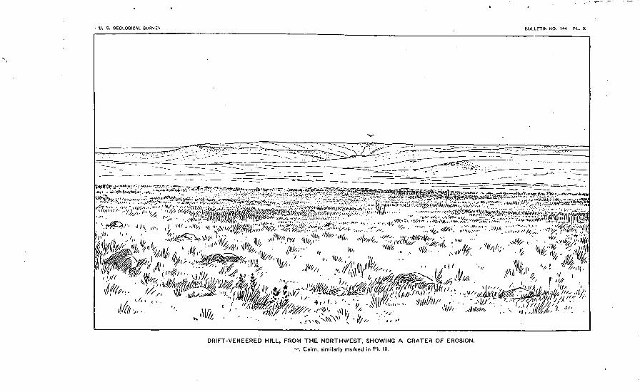
The Eee Hills are probably largely composed of Cretaceous clays in situ. About G miles south of Eee Heights a whitish "soapstone" or clay was found withiu 100 feet of the highest point of the hills, and farther south in a prominent bluff this was less distinctly traced con siderably higher. The hills lie along the northern edge of the table land which ends in an abrupt edge looking south. 'This front extends east and west about 12 miles and about that distance south of the Chicago and Northwestern Railroad. This bluff seems to have been formed by the erosion, of numerous branches of Boxelder Creek, which have removed quite rapidly the Cretaceous clays. South of the west ern half of the moraine the country was examined to the great bend of the Missouri, and found to present erosive topography, but with a fine veneering of drift, in which, bowlders were abundant, especially at certain points. It was thought that the northern side of the hills exhibited more bowlders than the southern, and in PI. IX a view is given of one of the most striking hillsides of this sort. Seen from the outside, it might be mistaken for a morainic hill, but an examination showed that erosion had developed in its front a crater-like basin, which is shown in PI. X. This basin exhibited"Cretaceous clays along its inner side and was clearly the result of erosion. Moreover, -the arrangement of these hills forbids the idea of their morainic origin. Artificial excavations not being found in the region, the depth of the drift can only be inferred.
THE BOXELDER LOOP.
This is in some respects the most perplexing and least satisfactorily explained portion of the moraine. The position of the morainic hills may be described as follows: South of a gap about 3 miles in width, which has been alluded to under the last heading, morainic hills begin on the east side of Boxelder Creek, near the south line of T. 110 $"., B. 70 W., in the southwest corner of Hand County, and continue in a southerly and southeasterly direction along the eastern side of the val ley of that stream, forming the watershed between it and the next branch of Crow Creek to the east. A slight reentrant angle heading toward the northeast is formed in the northern part of T. 107 N., E. 6i> W. With this irregularity it continues directly to Crow Creek, near the eastern line of Buffalo County, south of Gann Valley. Thence eastward, where it is much less distinctly developed, consisting mainly of scattered knoll ridges, rarely over 15 feet in height, nearly 12 miles, when it turns northward and soon joins a high, irregularly triangular area covering the most of T. 108 K, E. 66 W. At its northwestern angle

U. S. GEOLOGICAL SURVEY BULLETIN NO. 144 PL. VIII
ji^&teggjgg^i^^f!SftJjW.f."V^^>(f?^. ̂ : f.'."^- ' "*"" -~V "vf. i^ .> y ~-^r*~ ̂ & -/l^-'-^^','' "<"''" '' i^'~^^': ".'?*.''*'' .
^i^^'^f^"/" ^ *&**, . *§!&. -' .^^^pjT ' " ***"" f '~/-^ JC.'^W-S- -^: ",'.'^.. :..-' ,»..,..'.', ^"- . -.-- - " '- --j
.,/- ; ^ "*' ; '""^4v- : "(,/^Wr^4ft^Ww^ y'::^J^a/^^'-'v^^^^^^ wj^^-^i^'f, ^ '^^^;^ji^
MEDICINE HILL, FROM THE NORTHWEST.

TODD.I THE BOXELDER LOOP. 29
it connects with a similarly high and stony area 3 or 4 miles in length north and south, lying along the western line of T.109 N., E. 67 W. A ridge 3 or 4 miles in length and a mile in width, of similar height and stoniness, begins at the southern corner of T. 110 N., E. 78 W., and extends north-northeast. From the northern angle of the triangular area a long, slender system of prominent knobs and lakes extends north- northeast to the edge of the plateau, or to the southeastern corner of T. 110 N., E. 66 W. From, the eastern side of the same triangular area the morainic hills extend southward in a very scattered, imperfect manner, and again upon the western side of Turtle Eidge a few points, suggesting a moraine, lie along the western side of its internal drainage channel.
With reference to the altitudes of these areas, we may state that the moraine along Boxelder Creek is about 1,825 feet above the sea, or about 100 feet above the plain inside, near the southern line of Hand County, and diminishes in altitude considerably toward the south. The altitude of the other areas may be put down at about the same figure. The detached area south of Miller, and which we may call, for convenience, Miller Island, rises about 140 feet above the plain south west, and is estimated to be about 50 feet above the even plain along its eastern side and 75 feet above that along its western side. For, extending from the Eee Hills southeast to the Wessingtons, there is a swell in the glaciated plain, as though the ice had passed over a pre- glacial ridge. It should be stated, also, that there is an extension of the plateau, which is about the same height as this ridge, running north from the triangular area to Silex Station. This may be consid ered as the northeast angle of the high land upon which the moraines south of the Eee Valley lie. Its eastern edge becomes high and more and more abrupt and stony toward the southeast till it forms the eastern side of the Wessington Hills.
In order to give an idea of the origin of these hills and at the same time a conception which may be more easily remembered, we may offer the following theory: Conceive four narrow lobes of ice pushing from the north-northeast, three of them west of the slender interlobe which extends to the northern side of the plateau, and the fourth east of that ridge between it and Turtle Point. Of the first three, the easternmost is obstructed by a ridge over which it does not reach. The other two break over it, become confluent, and, passing into the valley of Box- elder Creek, turn with it toward the southeast and pass in front of the third lobe, coming nearly in contact with the fourth. As a result of this adjustment of the ice, the drainage from the third and adjacent sides of the other lobes is discharged southward between them into Crow Creek. This interpretation seems to be corroborated by the cur rents along the southeastern sides of all these island-like areas of unusually stony ridges resembling osars, and also by a prominent southward drainage channel in the triangular area, as well as by the

30 MORAINES OF THE MISSOURI COTEAU. [BULL. 144.
great abundance of sand and gravel in the whole southern part of this region. These stony hills lie upon a terrace which shows more or less distinctly at different points.
THE DEPOSITS' CONNECTED WITH THE OUTER MORAINE.
As the Second moraine lies very close to the First, wherever the lat ter approaches the James Eiver Valley, we need to consider under this head only the region lying on the Missouri side of the Coteau. In the area under consideration this readily divides itself into three areas inside the moraine, viz, the Long Lake loop, the Blue Blanket loop, and the Eee Valley loop; and three outside, viz, the three lying between them, or south of each, respectively.
A COMPARISON OF THE AREAS WITHIJST THE FIRST MORAINE.
Of the areas within the First moraine we have already spoken, and need only to add a statement of their general resemblances and differ ences. Their resemblances may be thus noted:
1. They have a common character, in that their drainage is wholly into the Missouri, and by streams which very rarely rise within the Second moraine.
2. They present less of the characteristic features of glaciated areas, and where these occur they are less pronounced and more modified by erosion and deposition than the areas within the Second moraine. In the Long Lake loop, while basins are abundant, and some of them large on the inner slope of the moraine, they are obscured in the bottom of the valley by lacustrine and torrential deposits, as about Tappen and Dawson. And not only at these lower levels, which are about 1,760 feet above the sea, but also in local areas at higher elevations, as near Steele, at an altitude of 1,857 feet, sheets of loess-like silt occur. At the latter place bricks are made from the silt deposit. The silt abruptly changes below into gravel, which shows flow-and-pluuge structure, as of currents from the east. In some places the gravel is abundant and is excavated for use on the railroad. Some of the narrow cuts near Steele show contorted strata. In the Blue Blanket loop, basins are fewer upon the slopes of the moraine, especially in the western part of the loop, where they are rare. The topography of the lower lands along the Blue Blanket and northward, which lie at an altitude of about 1,675 feet, is not glacial, but rather lacustrine. The southern part of the loop, for the most part, presents erosive topography, with occasional basins, which seem clearly to be of glacial origin. It is covered very generally with a loam resembling loess. The altitude of this region varies, sloping from about 1,700 feet at the north to 1,900 feet at the south, and rising still higher at the southeast. This probably accounts for its greater erosion, the difference between valleys and hills being sometimes 50 feet. The Eee Valley loop has already been alluded to as unusually even. Basins are found, but they are few and usually quite shallow. Some of them have broad, widening forms,

U. S. GEOLOGICAL SURVEY BULLETIN NO. 144 PL. IX
' '' "''< < *''''' t-1 \ ''t'' ' 'V >. ^jI^JJ-j^-^U T^W '' ' '. v ;. .>.,«,; >.; v }f »-^r ' / ^^
DRIFT-VENEERED HILL, FROM THE WEST.

TODD.] DEPOSITS OF THE OUTER MORAINE. 31
suggesting ancient channels. One of these was especially noticed run ning south-southeast for 2 or 3 miles across the northeastern corner of T. Ill N., E. 78 W. It was more than one-half mile wide and 10 feet or more below the general surface. This area also is covered with silt in large degree. Its altitude, as has been stated, is from 1,750 to 1,900 feet. There is no such erosion of the surface as is shown in the Blue Blanket loop, except in the vicinity of the Missouri.
3. All the loops illustrate greater westward elongation. This is to be explained mainly by the pre-Glacial topography. At the east front of the plateau the axis of the lobes of ice occupying these loops was depressed 300 to 400 feet below the high, interlobular ranges like the Bowdle and Wessington hills. Another reason for their greater elon gation is doubtless found in their relation to the main trunk of the Dakota ice sheet, which occupied the Eed Eiver and James Eiver valleys.
A few differences may be noted. The Long Lake loop was consider ably more sandy than any other portion of the moraine. This is trace able to the Fox Hills sandstone. The Blue Blanket loop was the most eroded and its course most crooked. The Bee Yalley loop pushed the farthest west.
THE REGIONS OUTSIDE THE MORAINE.
The first of these occupies Emmons County and the western, parts of Logan and Mclntosh counties, and will be called the Beaver Creek region. The second, which occupies the area between the Blue Blanket loop and the Eee Yalley loop, will be called the Little Cheyenne region, from the principal stream which drains it. The third, south of the Eee valley loop, will be called the Crow Creek region. These are all more or less covered with drift, usually with a deposit resembling till. The region least covered with drift is that lying east of the Great Bend of the Missouri, or in the western part of Buffalo County. This is the summit of a broad divide, and shows no drift except scattered bowlders, perhaps one or two to the square mile. There are many places in all of these regions where erosion has removed the drift, more particularly along the steep slopes of streams and on the sides of buttes or very steep hills. Sometimes a hill may be entirely free from drift when the cause of its absence seems clearly to be erosion. The topography of all these regions is almost purely erosive. Basins and lake beds are found to some extent, but considerably less frequently than in the regions inside of the moraine, and no more are found than in regions beyond the margin of the drift. The Cretaceous clays which underlie most of these ridges is peculiarly subject to slipping and settling, which tends to produce basins capable of holding water. In all of them the streams are deeply eroded below the higher levels, sometimes to the extent of 400 to 500 feet, especially near the Missouri. Bowldery knolls are not entirely absent. These, as has been stated, are found along the sides of channels, as south of Swan Creek and about the edge of plateaus, as in two or three cases noted in the Beaver Creek region.

32 MOEAINES OF THE MISSOURI COTEAU. [BOLL. 144.
The Beaver Creek region is occupied throughout, with perhaps the exception of the southeastern corner, by the Fox Hills sandstone. This forms the capping of a table-land and of buttes, high and very picturesque, along the streams, such as Beaver Greek, and down the Missouri to Lagrace and to the mouth of Grand River on the west side. The sandstone contains layers which have become metamorphosed into a very compact, greenish quartzite, and these layers abound in imprints of vegetation, particularly the casts of vertical stems. These layers contribute very many small bowlders which have been widely distri buted, especially along the moraine bounding this region. 1
The Little Cheyenne region shows no distinct trace, as far as has been yet found, of the Fox Hills sandstone, but is underlain with shales and clays of the Pierre group, and fine, white, loamy sand, with calca reous concretions, which may be of Tertiary origin. No flat-topped buttes are found in this region except low ones, such as may be noted in valleys where they have been cut out of gravelly terraces. This region is drained by the Little Cheyenne and by Swan Creek. The drift is generally from 10 to 25 feet in thickness.
Of the Crow Creek region mention has already been made in a pre vious report,2 and it is necessary to add only the fact that the northern portion of this region down to the latitude of the northern end of the Great Bend seems considerably more covered with drift than south of that line. A drift-veneered hill from this region is shown in Pis. IX and X.
Entering T. 120 N., E. 76 W., near its northwest corner, is a singular ancient channel (PI. XI) which crosses the table-land between Swan Lake Creek and the Little Cheyenne in a southwest direction. It is 2 or 3 miles long. Its bottom is about 400 feet above the Missouri, and its sides in some places are bordered with bowldery knolls, resembling osars. In connection with this feature, brief mention may be made of the peculiar character of the margin of the drift farther west. On the northern slope of the Fox Hills the margin of the drift is very conspic uous, whether we refer to the sudden change of very abundant bowl ders, to entire absence of them within a few rods, or to the unique way in which the margin stands out as a flat-topped ridge above the surrounding region. This marginal ridge, rising sometimes to a height of 40 or 50 feet, with its top nearly horizontal, runs in an easterly direction along the north slope of Fox Eidge and about 50 feet lower than its crest. This marginal ridge is that mentioned by Prof. G. F. Wright. 3 These phenomena raise the query whether they are not traces of a great glacial lake, which occupied, for a short time at least? the region north of Fox Eidge, before the Missouri cut through so as to drain it.
1 The strata furnishing these bowlders, as has been now discovered, belong to the Tertiary, prob ably to the lower portion of the Loup Fork formation.
2 The memoir here referred to, on The terminal portion of the Dakota loop of the Great Moraine, has not yet been published.
3 The Ice Age in North America, p. 140, and more fully treated in Proc. A. A. A. S. 1888, p. 210.
U. S. GEOLOGICAL SURVEY BULLETIN NO. 144 PL. X
V/A '.,*«** ;.-, '-'/^
DRIFT-VENEERED HILL, FROM THE NORTHWEST, SHOWING A CRATER OF EROSION.
-«-, Cairn, similarly marked in PI. IX.

CHAPTER II.
THE SECOND OR GARY MORAINE, WITH ITS ATTENDANT
DEPOSITS.
G-ENERAL LOCATION OF THE MORAINE.
As compared with the First moraine, the Second does not extend so far west, and consequently lies generally at a lower level. It is always less massively and less conspicuously developed than the First in sirn- iLar circumstances.
Its course may be described as follows: It crosses the Northern Pacific west of Crystal Springs. It is very prominently developed 2 or 3 miles south and southwest of that place, and after a short curve to the west it takes a south-southeast direction past the southwestern cor ner of Stutsman County to the eastern boundary of T. 135 ]ST. ; E. 79 W., where it turns eastward, is more broken into detached portions, and soon takes a northeast direction and passes around the inter lobe formed by the First moraine at the northeastern corner of Logan County. This portion we will call, after the corresponding portion of the First moraine, the Blue Lake loop. Thence along the eastern side of the same inter- lobe south and a little west to the southeastern corner of Logan County, where its course is somewhat indefinite, as has been suggested in the discussion of the First moraine. It would seem reasonable to expect to find it in the hills lying along the west line of Dickey County, extending a little east of south and joining the First moraine near the head of the Koto Hills, but instead of following the First moraine closely from that point, it returns to the north along the eastern edge of the plateau into the southeastern corner of T. 132 K, E. 65 W., near Merricourt. This portion we will call the Antelope Valley loop. Its course along the Koto Hills has already been given. From the southern point of the Koto Hills, about 7 miles northwest of Leola, it turns sharply westward. It continues in this course along the south side of of the valley of Spring Eiver to a point 6 miles south of the north western corner of McPherson County; thence by a quite regular curve to the west, reaching nearly to the middle of Campbell County, it sweeps along to the northeastern corner of Walworth County, north of Bowdle, where it joins with the First moraine. Tbis portion we will call the Blue Blanket loop. Its course in connection with the Bowdle Hills has already been given. From a point a little west of Seneca it turns east ward and forms a complicated system of curves which is unlike any thing before described, and returns again to the south end of the Bowdle
Bull. 144 3 33

34 MORAINES OF THE MISSOUEI COTEAU. [BULL. 144.
Hills near the northwestern corner of Hyde County. This complicated portion, which has no counterpart in the First moraine, we will call the Faulkton Hills, or the Bald Mountains, according to a somewhat com mon local name. From the northwestern corner of Hyde County the moraine extends around in a regular curve a little south of Highmore, and keeps an east-southeast course to the eastern side of the county, where it joins the First moraine. This constitutes the Eee Valley loop.
From the southeastern corner of the Eee Hills to the' hills north of Turtle Point, in Jerauld County, the course of this moraine is as prob lematic as that of the First. Three interpretations seem possible. One, that the detached clusters of hills southeast of the Eee Hills are the representatives of this moraine, with unusually wide outlet channels between. Another, that during the occupation of the Second moraine, the ice for some reason overrode the First moraine, which lay along this line of clustered hills or glacial islands. According to this supposition, the hills along Crow Creek might be representatives of the Second moraine. A third explanation would suppose the moraine faintly devel oped in a few knolls that lie along the northern edge of the plateau north of these clustered hills and in the more conspicuous stony knobs along the eastern side of the plateau south of Wessington Station. No one of these interpretations is very satisfactory. The objection to the first is, that the shaping of the clustered hills or glacial islands does not favor such a view, nor do the narrow plains between indicate the action of water to the extent that this theory would imply. To the second is the objection that no known cause can account for the exceptional advance of the ice at this point during the occupation of the Second moraine. To the third, it is difficult to see why the moraine should not be considerably more developed than it is south of Miller, where it is scarcely noticeable.
DETAILED DESCRIPTION OF THE MORAINE.
THE BLUE LAKE LOOP.
The Northern Pacific Eailroad passes down what appears to be an old outlet channel through this moraine west of Crystal Springs. The moraine southwest of Crystal Springs is finely developed, rising to a height not less than 125 feet above the plain to the west. This portion has not been visited and can be spoken of only from distant views. A little south of the southwestern corner of Stutsman County the moraine was visited at a favorable point and an extensive view gained both north and south. At that point it rises to a height of nearly 200 feet above the plain northeast and 100 feet above that southwest. This magnificent development seemed to continue for several miles to the southeast. After it turns toward the northeast it becomes broken into detached clusters of hills rising to a height of 75 to 100 feet above the uneven plain around. Everywhere it is attended with numerous basins, some of them evidently being portions of old channel?. From a dis tance it was judged that there was a gap near the north end of Lake

U. S. GEOLOGICAL SURVEY BULLETIN NO. 144 PL. XI
ANCIENT CHANNEL SOUTH OF SWAN LAKE CREEK.
Looking southeast from neai southeast corner of sec. 32, T. 121 : R. 76.

TODD.] THE BLUE LAKE LOOP. 35
Edwards, in southeastern Kidder County, and another near its south end. A still more conspicuous gap, toward which a prominent line of depressed lakes leads and which cuts down to the level of the plain, is a little south of the southeastern corner of Stutsman County. The drainage of this loop in its western half and possibly through its whole extent was into a plain lying between it and the First moraine, which it is judged drained northwest into Long Lake Valley. The plain west' of Napoleon was 5 or 6 miles wide and much of it was covered with a fine layer of loam, while in other places it was very gravelly or sandy. From the north an outlet from Lake Edwards into Long Lake Yalley was noticed, and reports of the same were gained from settlers.
Inside of this principal line of the moraine, extending nearly parallel with the outer number, is a system of clustered hills, which, in the northeastern part of Logan County, are quite conspicuous, rising to a height of 60 to 70 feet above the surrounding country, One of them visited presented the unusual appearance of a flat-topped butte with numerous lake beds around it and leading from its southeastern side. The moraine is very imperfectly developed along the head of the inter- lobe in northeastern Logan County, especially toward the north, where the material of the moraine was probably carried away by drainage. From that point a line of depressed lakes and lake beds circles around the higher hills to the west and leads southward for at least 6 miles j how much farther was not determined.
HE ANTELOPE VALLEY LOOP.
Outside of the line of lakes just mentioned the clustered hills of the Second moraine rise 50 to 60 feet. The western course of these along the side of the great interlobe has been examined only from a distance, and they have not been distinctly separated from those of the First moraine! At the southeastern corner of Logan County the hills disappear, and none are found in the main direction of the moraine nearer than 4 or 5 miles, when a line of hills, depressed much of their height below the general level, begin and extend southward to the southern part of T. 131N., B. 66 W., as has been before stated. South west of this gap there is a plain reaching to the Outer moraine, which is the eastern half of Antelope Valley. Along its western side is a prominent line of hills running southwest, which has been described as possibly either the inner number of the First moraine or an inter- lobe from its outer member. We now suggest that it may be possibly a portion of the Second moraine; if so, the line of hills in T. 131N., E. 66 W., may be considered an interlobe, and the numerous deep A^alleys found in it rather favor this view. The hills of the Second moraine, extending along the edge of the plateau northward to Merricourt, are not massed into a ridge, but are scattered, their highest points rising from 25 to 40 feet above the land to the west and about 400 feet above the edge of the plain east. The hills are lower toward the north. The drainage of this loop was mainly to the south and southwest.

36 MORAINES OF THE MISSOUEI COTEAU.
THE BLUE BLANKET LOOP.
Northwest of Leola these hills lie upon the crest of the table-land and present several prominent knobs, stretching first southwest then turning quite directly west, which direction the inner edge of the moraine seems to keep as far as Hills view, on the north line of T. 125 N., E. 72 W., but the whole region north from this line to the north branch of Spring Biver, a breadth of nearly 12 miles, is more or less studded with detached knobs, although the region between is com paratively even. It is not improbable that the northern edge of the ice occupying this loop receded, on the whole, quite rapidly during the formation of the Second moraine. About 6 miles south of the south west corner of McPherson County lies an east-and-west ridge 5 to 6 miles in length, which doubtless belongs to this moraine. West of it is a gap or vacant area, and again the hills rise prominently in the west ern half of T. 127 1ST., E. 74 W., and continue west and southwest, increasing in height and breadth. Northeast and east of Mound City the moraine is quite continuous and rises above the valley west about 100 feet. From the vicinity of Mound City it curves to the southeast, preserving its prominence to the southern line of Campbell County. Near the northern line of that county, and outside of the moraine, is a cluster of sandhills more or less covered with trees. These result from the sands accumulated by the drainage of this loop to the southwest. The moraine continues with somewhat less prominence in an east by south direction! to the Bowdle Hills. As it rises on the slope of the Outer moraine it puts on a rougher form. The region in the terminal part of the inside of this loop has not been closely examined, and judging from its eastern portion it maybe occupied more than usual with scattered hills. This loop drained along its northern side intoSpring River, which appears to owe its existence to this cause. Thesouthwestern portion drained into the Blue Blanket Creek.
THE BOWDLE HILLS.
Of this group little need be said, except to notice the distribution of some of its inner portion in southwestern Edmunds County. After its close association with the Outer moraine east of Bowdle it withdraws more to the east, especially in its later development, so that quite con spicuous hills are found as far east as the southwestern corner of T. 121 N., E. 71 W., although they are much scattered. Farther south they return to the vicinity of the Outer moraine, forming a distinct ridge running southward about 6 miles east of the west line of Faulk County. In this portion they show few prominent knobs and the ridge is distinct, though narrow. Its inner edge continues to the southwest corner of T. 119 N., E. 73 "W., where it turns to the southeast. The western part of the ridge rises in contact with the Outer moraine a little west. The drainage of this part of the moraine at its northern

U. S. GEOLOGICAL SURVEY BULLETIN NO. 144 PL. XII
^ ^ ff.2-.'-^ -"-- ^.^xS-'Tsi-;"15 -- =---*£-.. :-.-- .a-tvfaf&cc*^?,: : ::': *:- ^/_4^&jr^'v~ 9 j-.'-.'l-^r.-'.
' '* ^5:^^^^-;,^%^^^^P^^- *--" ^
ANCIENT CHANNEL NORTHWEST OF LEOLA.
Looking S. 56° E. (megnetic) from sec. 19, T. 127, R. 69.
»-, First moraine, from inside; --- *-, Second moraine from outside; -*-^--^, channel.
TODD.] THE FAULKTON HILLS. 37
end was over the First moraine for 10 to 12 miles above Bowdle; farther south the waters seemed to have found a way outside of the First moraine southward to Pembroke Gap. The weaker development of this moraine in its southern portion may be partly accounted for by the steep slope of the region to the northeast. Near the southwestern corner of T. 120 K., B. 72 W., a conspicuous isolated hill was visited, which' resembles a drumlin more nearly than any other that we have observed in Dakota. It is of an elongated, dome-like form, about 30 feet in height above the plain around.
THE J'ATJLKTON HILLS OR BALD MOUNTAINS.
The name Bald Mountains has been a/pplied to these hills probably through a misunderstanding. It was first given to a conspicuous hill about 8 miles west-southwest of Bedfield; then it was applied to the more imposing elevation southwest of Faulkton; but this becomes much less impressive as one approaches it, and Avhen entered the hills are seen to be of slighter development than at many other points in the Outer moraine, or even in the Second moraine.
The course of the moraine may be described as follows: Its inner line, curving southeast from near Seneca, turns east and forms a reei> trant angle southeast of Ellisville, where it is finely developed for 3 or 4 miles. Thence southeast again to the southern line of the gap, which it follows eastward 5 or 6 miles, then takes a northeasterly course to a point 2 miles west of south from Faulkton; thence nearly due south and a little west and somewhat beyond the south line of the county, where it curves quite sharply to the west, which direction it keeps for about 12 miles, thence west-southwest to the southeast corner of T. 116 N., B. 73 W.
The region bounded by this line is covered quite closely with, inorainic hills rarely over 30 feet in height, except in the southwest corner of Hyde County and in two or three points southwest of Faulkton, near the county line, where a height of 100 feet above the inclosed basins is reached. The eastern side of the moraine south of Faulkton lies upon the eastern edge of the high land, which gives it an imposing appear ance. Through its eastern ridge are two gaps or outlet channels, show ing that this system of hills possessed the features of an interlobe with internal drainage. The water thus entering jt found its way among the hills toward the west, and probably did not escape from the moraine for 20 to 25 miles. The peculiar form of the moraine here is traced to a pre-Glacial ridge extending from the southeastern corner of Potter County nearly east a,long the parallel of 45° to a point south of Faulk ton. It corresponds in direction and altitude to Fox Bidge, west of the Missouri, and may be its-continuation. This ridge in its present condi tion may be estimated to be about 6 miles wide and 20 miles long. At its eastern end, where it lies along the eastern edge of the more exten sive plateau, it rises about 300 feet above the James Biver Valley. Its height westward is quite uniform and rises about 150 feet above the

38 MORAINES OF THE MISSOURI COTEAU. [BULL. 144.
sloping plain to the north and probably as much above the plain south. This ridge evidently was overridden by the ice during the occupation of the First moraine, but in the time of the Second it formed a barrier which stayed the ice from the north so that ablation kept pace with its advance and thus produced the deposition of the moraine along its 'southern side. The drainage from this was very abundant, mainly along the south side of the moraine and thence northwestward through to the vicinity of Copp on Okobojo Creek. Two remarkable outlets are found in northwestern Hyde County, one of them leading west just south of the northern, line of the county and south of conspicuous hills over 100 feet in height, composed mainly of gravel, which we may sup pose was first deposited during the period of the First moraine and afterwards reshaped by the ice of the Second. This channel is nearly half a mile wide and with low gravelly terraces in its bottom. This we will call Oleson's outlet. The other leads northwest from near the southeastern corner of the same township, and is remarkable for its double character. Its two channels of nearly equal size are accompa nied by an osar ridge about 20 feet in height and extending for at least 2 miles. This we will call Hunt's outlet. Both of these outlets are quite straight, and large quantities of gravel are deposited near their mouth east of Copp. The later drainage of this moraine in Hyde County was more to the southwest, and has left its trace in a system of lake beds which finally gather into the north branch of Medicine Creek.
THE REE VALLEY LOOP.
From these gaps the moraine soon takes a southern course and occupies most of the seventy-fourth tier of townships from a few miles south of Copp nearly to the east branch of Medicine Creek near the southeast corner of Sully County. This portion of the moraine has not been closely studied, though much has been learned of it by dis tant views and by inquiry. A preliminary railroad survey has been run from Copp to Harold. About 8 miles south of Copp the elevation is about 1,950 feet, a little farther north 1,885, and a few miles farther south an average of about 1,750 feet, while the east branch of Medicine Creek along this line has the altitude of 1,660 feet. From 3 to 4 miles north of the southwest corner of Sully County the moraine extends southeastward past Hrghmore, and turning more to the east joins the Outer moraine at the Eee Hills. This portion is characteristically de veloped in numerous knolls and ponds, none of them being particularly conspicuous. The altitude in the vicinity of Highmore is about 1,895 feet, or about 20 feet above the plain northeast and 50 feet above the valley of South Medicine Creek, which drains its outer slope.
THE BOXELDER LOOP.
As before stated in our discussion of the First moraine, the Second skirts the eastern end of the Eee Hills, and a portion seems to circle around nearly to Boxelder Creek, but the real course has not been

U. S. GEOLOGICAL SURVEY BULLETIN NO. 144 PL. Xlll
! ''.-J»;,:',
' -"V ,:--'' V » -^ '^ '
OSARS NORTHWEST OF EDGELY, FROM THE SOUTH.

TODD.] AREA WITHIN THE SECOND MORAINE. 39
satisfactorily determined. If it is interpreted to correspond to the shoulder-like edge of the highland, it circles southeast from the Eee Hills south of Miller about 10 miles, to about 12 miles south of St. Law rence, where it curves toward the northeast, then to the north to the vicinity of Silex, thence south, doubling upon itself, and southeast, leaving the edge of the plateau a little north of Turtle Point, then taking its course upon the plain of the James Eiver Valley, along the head of the north branch of the Firesteel, it shows a tendency to break into two or three ranges. Its further course has been described iu a
[previous paper. :
THE REGION INSIDE OF THE SECOND MORAINE.
The First and Second moraines are considerably more closely related than the Second and Third; therefore the region between the latter two is quite extensive and important, as the Third lies in the James Elver Yalleyand nowhere rises upon the plateau west while the Second is almost wholly upon the plateau. A description of this region is really a description of the east slope of the Coteau du Missouri. It therefore may be well to trace approximately its eastern edge. This edge, for
Via. 1. Section west of Hediiia.
the most of its course, is marked by an abrupt rise sometimes of 150 to 200 feet in 2 or 3 miles, making it difficult to ascend with a wagon except by taking advantage of ravines. It crosses the Northern Pacific at an elevation of nearly 1,900 feet and declines gradually toward the south, being between 1,600 and 1,500 feet south of Leola. It crosses the Northern Pacific near Cleveland and extends southward nearly to the northwestern corner of Lamoure County, then curves eastward around the head of the interlobe and takes a south by east course, passing a few miles west of Edgeley through Merricourt, where it changes to a south course to the vicinity of Lorraine, 15 miles west of Ellendale. There it changes to a south by west course and passes near Koto and Leola, thence south ward, becoming indistinct, and apparently curving to the west, passing west of Ipswich. It appears distinctly again at Faulkton aud continues around the Faulkton Hills, when it again becomes indistinct and curves away to the west, perhaps into Hyde.County and again reappears near the east end of the Eee Hills, thence following the line which we have traced as the possible Second moraine south of Miller and curving northward to a point near Silex,
i A report on The terminal portion of the Dakota loop of the Great Moraine, not yet published.

40 MORAINES OF THE MISSOURI COTEAU. [BULL. 144.
then following a southeast course toward Turtle Point. This line may be taken as the axis of the region under consideration.
The character of this region is in general quite similar throughout, everywhere showing the peculiar swell-and-sag topography character istic of glacial regions. By reason of its abruptness the edge of the coteau is frequently cut with ravines or gulches, which are commonly attended with unusual accumulations of bowlders. In most cases there
Eio. 2. Section east of Medina.
seems nothing remarkable about them, but northwest of Edgeley, in a valley just west of the edge, there rises a system of bowldery hills re sembling osars, arranged in a broken ridge along the axis of the valley. These are shown in Pis. XIII and XIY. Their origin seems likely to have been the reversed drainage toward the east underneath the ice when it occupied the region. Morainic hills appear along this edge, as though the obstruction of the ice produced a dropping of some of its inclosed material. This may account for some of the bowldery hills already mentioned, and more certain illustrations are found east of
FIG. 3. Section west of Cleveland.
Medina and southwest of Edgeley and again about the Wessington Hills, especially northwest of Turtle Point. In this latter case the knobs or clusters of bowlders are often remote from the gulches, and sometimes rise above the general level. East of the foot of the Coteau the surface is usually covered with silt and slopes very gently and evenly toward the east. This is evidently the result of wash from the hills.
Upon the Coteau in the Blue Lake loop the topography is unusually uneven, the hills and basins being as pronounced as in the moraine at other points. Frequently the hills rise to the height of 30 to 50 feet

U. S. GEOLOGICAL SURVEY BULLETIN NO. 144 PL. XIV
^^^,,: i4.7A... ;:.-;^^>^^ .~-^:,,;.^rr : . - .~..^
OSARS NORTHWEST OF EDGELY. FROM THE EAST.

TODD.] AREA WITHIN THE SECOND MORAINE. 41
above the deep basins between, and are usually from half a mile to a mile apart. From the north line of Lamoure County the plateau is somewhat smoother, and near its edge through the southwestern part of that county a line of lakes in a channel just west of a swell ridge was noticed, indicating that the drainage for a time was southward, before the ice had entirely receded from the foot of the plateau. Below Merricourt the line lies close to the moraine and the slope is very steep and furrowed with ravines. The area inside of the Blue Blanket loop and east of the Bowdle Hills, while presenting few prominent points, yet resembles the first region in roughness for the most part. The Kee Valley, on the contrary, is very even, few hills rising more than 10 to 15 feet above the basins. A view of a fine osar, 8 miles north of Bowdle, is seen in PI. XV.
East of the line which we have traced as forming the edge of the plateau, the country is much more even, and has generally been the firsttaken by settlers. Very rarely are elevations abrupt enough to deserve the name of hills, though broad swells less than. 10 feet in height are not uncommon. Throughout its whole extent there are shallow basins and channels that indicate more or less drainage toward the south, which, however, has not been rapid or excessive enough to wear deep channels.
Some interesting sections from this region along the Northern Pacific are shown in figs. 1, 27 and 3.
THE DRAINAGE OF THE ALTAMONT AN3D GARY MORAINES.
To avoid unnecessary repetition, the drainage of the Altamont and Gary moraines has been lightly touched upon, for the conviction was early reached that it could not be well given as a whole before the loca tion and character of the moraines were in mind. In the examination of drainage channels outside the moraine pressing questions, difficult to solve were, "What is the age of the gravelly and bowldery terrace or terraces so prevalent along streams'? When was the principal terrace formed during the occupation of the First moraine or during that of the Second ?" The Missouri has not only the silt terraces, which are of comparatively recent origin, at least later than the glacial epoch, but one or more bowldery terraces. They have not been very fully examined north of Lagrace, although their existence has been observed at Bismarck and near Fort Yates.
Along Apple Creek, the outlet of Long Lake Valley, no very promi nent or elevated terraces were noticed, although south of Sterling one was found about 36 feet above the bottom of the valley, and along Sand Creek, south of Long Lake, terraces were found 10 to 15 feet above the stream near Merriam, and west of Napoleon only 3 to 4 feet above, indi cating that for some cause the erosion along this channel was compar atively slight and that the amount of material of bowldery character
, was limited.

42 MORAINES OF THE MISSOURI COTEAU. [BULL. 144.
Beaver Creek shows, south of Napoleon, a terrace not very distinctly formed, 100 feet above the stream. Near Beaver Lake it is well devel oped to the height of 65.feet. Ascending the south branch of Beaver Greek we find first a narrow valley between the moraine and the table land west. This soon widens to 3 miles near Green Lake and to 10 or 12 miles near Ashley, and southeast from that point it seems to fill the whole space bounded by the Koto Hills and adjoining loops of the moraine. On the west side it extends up two or three tributaries into the table-land. This plain is more stony next to the moraine and a few feet higher, while its central portion is more covered with loam and free from stone. This plain is clearly a terrace about Green Lake, but south and southeast becomes a plain pitted with lakes. The general difference in elevation between the lakes and the upland is 40 to 50 feet. It may be that the whole region has been mostly filled to that depth. Such at least is shown to be true west of Ashley by artificial excavations. The higher levels between the lakes are frequently cov ered with loam, while lower surfaces and shoulders, which are about 30 to 35 feet above the lakes, are composed of stratified gravel 5 to G feet in thickness. The surface of the plain is considerably more excavated toward the northeast side, near the principal outlets of the moraine. At Lagrace a bowldery terrace is rather indistinctly shown about 240 to 250 feet above the Missouri and another much more distinctly shown at 100 feet. At Lebeau, a terrace 300 feet high lies in the angle between Swan Creek and the Missouri (PI. XVlA). Around to the southwest and even extending as a channel through north, connecting the valleys of the streams, is a terrace 200 feet above the river. At the mouth of the Moreau, opposite this point, is a finely developed terrace estimated to be at the same level. This terrace is found developed along Swan Creek, south of Baugor at about 100 feet. above the stream, and at Swan Lake the stream has risen nearly to its head, A view of Spring Lake outlet, through which much water poured into Swan Creek, is and shown (PI. XVlB) and osars (PI. XYII). Above the mouth of the Little Cheyenne is a fine exhibition of a bowldery terrace, which stands 250 to 270 feet above the river, and extends with considerable width most of the way from Forest City to Fairbank (PI. XVIII). At Pierre, just north of the city, is a terrace having its higher points 325 feet above the river, although much of its surface, which is more than a mile in width, is about 270 feet (PI. XIX). About Medicine Butte there is an accumulation of drift having the form of a terrace. The summit of the ridge east of Canning resembles a terrace (PI. XX). Again, from Jones Landing, 15 miles south of Blunt, extending through to the Great Bend, is an unusually broad development of this terrace at the height of 270 to 300 feet. In the Great Bend a terrace rises nearly to the height of 235 feet, but its low development is probably the result of erosion.
Chapelle Creek and the other streams in this region show no terraces higher than this one that has been traced along the Missouri River.

U. S. GEOLOGICAL SURVEY BULLETIN NO. 144 PL. xv
OSAR, SEVEN MILES NORTH OF BOWDLE.

TOED.] DRAINAGE OF THE FIRST AND SECOND MORAINES. 43
Tims far we have spoken of streams entirely external to tlie First moraine, with, the exception of Spring River. A few of these extend their tributaries, either recent or ancient, into the region between the First and Second moraines. The Second moraine is drained by Apple Creek, through Long Lake Valley, from near Crystal Springs, and through Lake Edwards and its valley, the principal outlets from this loop. Beaver Creek, through Blue Lake outlet, Green Lake, and Rus- sian and Dutch outlets, also passes inside of the First moraine. Swan Creek does the same through Pembroke outlet by its south branch, while the north branch received water from the Second over the First about Bowdle.
Furthermore, after the vacation of the First moraine, a new set of streams arose to drain the Second, viz, Spring River, Blue Blanket, Artichoke, Okobojo, and Medicine creeks. These lie for most of their course between the moraines, They do not differ greatly from the previous class of streams except that bowldery terraces are not so clearly marked. Their upper portions in the vicinity of the Second moraine are usually broad, shallow valleys occupied by low sand or gravel terraces, as in the case of Okobojo, near Copp, the Blue Blanket, in Campbell County, and Spring River, in McPherson County.
Not only did these streams receive water from the ice sheet when occupying the Second moraine, but in a few cases the present drainage extends within the Second moraine. For instance, the western portion of the Blue Lake loop of the Second moraine drains westward into Lake Edwards; so also the southern portion of the Antelope Valley loop and the northwestern portion of the Ree Valley drain through the Second moraine. With these slight exceptions, the Second moraine forms the divide between the Missouri and James rivers.
It will be seen from this discussion that in almost every case impor tant streams outside the First moraine received waters from the Sec ond; also that it is very difficult to decide from which moraine the terrace deposits were derived. It is not unlikely that both may have contributed to them. From the study of the region about the head of the south branch of Beaver Creek, it would appear that there was a period of rapid deposition followed by one of corrasion and excavation. The first suggestion would be that both marked different stages of the occupation of the First moraine, but the relation of channels to the Second moraine render it possible to suppose that the deposition may have been during the First moraine, while the excavation was princi pally during the second. We must conclude, however, that data have not been sufficiently collected to satisfactorily determine the question. 1
1 Farther discussion of tbis subject may be found in Proc. A. A. A. S., Vol. XXXVII, p. 203; also Bull. No. 1, South Dakota Geol. Survey, p. 123.

44 MORAINES OF THE MISSOURI COTEAU. [BDIX. 144.
Table of terraces along the Missouri.
Locality.
Tort Sully,!.... ....................................
Silt terraces.
30,50,75.................12, 50, 100'[?]...... ......40.......................20, 75-100,175 [?]........10,35,65,125.............45,90,145................5, 20, G5...... ............
10 12,50 65,90 100.......10 15,65,110-150 ........8,15,45,65 80,125-160....5,15,30,70...............15, 63 [?]...... ..........
Lower bowldery terraces.
2601?]240-250240-260200, 300250-270o.-.n ovn
270-350 [?]
310-325275-325270-280290-3-10
Higher bowldery terraces.
400 [?]
400-450 [ ?]
1 The letters 1 and r indicate left and right sides of the river, respectively.
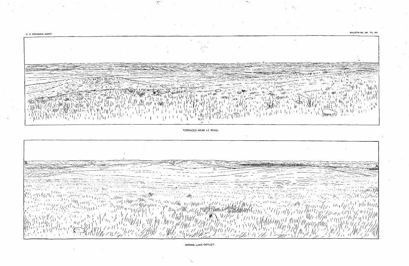
U. S. GEOLOGICAL SURVEYBULLETIN NO. 144 PL. XVI
- >,l r~- I \ | i, -'~ ;^~, ../)nff*"' " " __ ,.- i' ",' i t,t-ii\ i iff"Y^^T-y^^rT^' ..... -.-^Uu"';; ;;'_-» » ^ " '-^..i,/ 1 ' ' /1 ^.%^5'nT'''"^1 ^'-'^' '^'- : ^;:.*'^'"^' 'i^'yA 11 I"'"M\V"' W^'A"UW- rr Tt'W- '"',j^' f-'iii Ar>' i','il'/:^ ,,/,: ii!\n,';
W!^^f, vlrljl " V'?iWi" , v , /\ i:'. -' " J ' / i"' <\> i '^ \V;:;'[>v r.'/iXiV.vj^ i,' -. , / v ,,,, ( ^^TERRACES NEAR LE BEAU.
v'://.^-'/^;^'--'- '- - /-';;AV:^V;,;^--'^/;:;..; / ^:-v'"^T/V'^^-^:'^,// ^f^V^.x 'VMl "^£ ^-y/////.ri'////, V^'^'r^;!-"'^'^^^^^^''^//'x/'n!/^ I ' ,.' /'//Hi,'" //(l! 'it/// 'l I . ,i;'.
^ll'^^ ̂ *'' i ^^l^'^^i^SPRING LAKE OUTLET.
OHAPTEE III.
THE THIRD AND LATER MORAINES.
THE THIRD MORAINE.
The burden of the work undertaken in this bulletin has been accom plished in the description of the Altamont and Gary moraines, as they are the more important record of the ice age, but the dying efforts of the icy giant were still characteristic, and exhibit morainic formations under somewhat different circumstances. For the most part the Third moraine consists of low, wave-like hills, rarely over 15 feet in height, lying on the even .plain of the James Eiver Valley. Sometimes, however, hills may be found 75 or even 100 feet high belonging to this moraine. Its drainage was very largely tangential, so that this still more atten uated the moraine by removing or spreading its material. In some cases the low, flat land seems to have favored the thrusting out from the ice sheet of small semicircles of ice or lobelets which have left their impress in small, crescent-shaped loops of knolls. These have been particularly noticed along the higher margin west of Ellendale. They have been observed, however, in isolated cases, inside as well as outside of the moraine.
COUKSE OF THE MOKAINE.
This moraine has not been traced so diligently as the previous ones, but in traversing the country frequent observations have been made upon it, so that its course is quite generally determined. It crosses the Northern Pacific about 12 miles west of Jamestown, where it is feebly developed. From there its course is southeast, curving more to the east, following the lower part of Beaver Creek to the James Eiver. Thence it is believed to connect with quite prominent hills running in a northwest-southeast direction in the vicinity of Lake Eckelson.
Lake Eckelson is evidently par-t of an ancient channel, lying depressed 10 to 15 feet below the general surface and 25 to 40 feet below the hills on either side. West of these hills is another chain of lakes extending toward the southwest. Lake Eckelson is about 6 miles in length, and toward the southwest is connected with other depressed lakes. How far these extend has not been determined. This is looked upon as being an internal drainage channel of an interlobe extending from the Third moraine toward the northeast. These facts are the basis of our general conclusion, together with the additional fact that the Third moraine seems to be absent west of the James Eiver, in northwestern Lamoure County. As has been stated, the connection between Lake Eckelson
45
46 MORAINES OF THE MISSOURI COTEAU. [BULL. 144.
and the moraine west has not been definitely determined. This is also true of its connection southwest.
This moraine is found again clearly developed east of Edgeley, in a strip of low knolls which from that point extend southward west of Monango and Ellendale down the north branch of Elm Eiver. It is found again well developed about 10 miles west of the northeastern corner of Edmunds County, occupying most of the sixty-seventh range of townships to at least the south line of Faulk County, and probably keeping the same direction nearly to the line of the Chicago and Northwestern Eailroad. It is next found running in a north-northeast direction north of Wessington Station, occupying the south bank of Turtle Eiver. This it follows to its mouth near Eedfield and turns eastward, lining the bend of the James Eiver east of Eedfield, where it loses its prominent character and seems to partially disapper in the lacustrine deposits of Lake Dakota. Hills are found near Crandon Station and again 3 to 4 miles west of Hitchcock and again very promi nently at Wolsey, where many of them are 25 to 40 feet above the inclosed basins. The ranges here have a southeast trend. A few knolls noticed along Cane Creek south of Huron are referred to this same moraine. The eastern side of the loop of which this is the west ern half has not been clearly determined. Enough has been learned to show that this, like the older moraines, was less prominently devel oped east of the James Eiver. There are low knolls in the vicinity of Cavour which probably represent this moraine, and again near Doland and about Andover.
South of Wessington Station are a number of very conspicuous knolls and knobs rising to the height of 40 feet above the plain west, which probably are to be connected with this moraine. Still, their position so far outside and their being in line between the interlobe of the First moraine lying upon the edge of the plateau north of Turtle Point and the interlobe near Eedfield, together with their vicinity to the Second moraine, incline us to refer them to that moraine. About 8 miles west of south from Eedfield is an isolated cluster of hills rising to the height of about 100 feet. These doubtless are to be connected with the Third moraine, although they can scarcely be called a part of it, but rather a glacial island or drumlin.
FURTHER DESCRIPTION.
The most pronounced development of this moraine is found in the vicinity of Eedfield, where three or four ranges rise to the height of about 75 feet above the surrounding plain. The Northwestern Eail road passes through a gap southeast of the town, which seems to have been an outlet to an internal drainage channel. These hills appear to be a prominently developed interlobe, with its eastern half imperfect, or possibly removed by the erosion of Lake Dakota on that side. The moraine is also prominent near Wolsey. The reasons for this develop ment have not been discovered.

U. S. GEOLOGICAL SURVEY BULLETIN NO. 144 PL. XVII
BOWLDERY KNOLLS NORTHWEST OF SWAN LAKE.

TODD.] DESCRIPTION OF THE THIRD MORAINE. 47
The drainage of this moraine is everywhere southward, and as a result the land outside is quite even and covered with lacustrine deposits. This is found to be true west of Eldridge, Ellendale, and Eedfield. At Wessiugton the rapid descent to the south and the nar row space between the moraine and the Coteau adjacent produced more erosion than usual, leaving a low terrace outside of the moraine. At several points the drainage from the ice into this external channel pro duced a succession of gaps that were near together, which left the ridges between en Echelon. This was noticed west of Eedfield and in the vicinity of Wolsey. Inside of the moraine also there is usually a shallow southward channel, and between the ranges less prominent ones are frequently found. The failure to discover the moraine north west of Wessington may possibly be due to its removal in the low land of the Eee Yalley, but more probably its development was so slight that it is not easily seen from a distance.
Attention is particularly called to the Eedfield interlobe. It would seem that in the retirement of the ice from the Eee Valley on the one hand, and the James on the other, this was the result of the rapid abla tion between these two great lobes. This fact is suggestive in connec tion with the question whether the moraines mark different epochs of the ice age or different stages in the recession of the ice of one epoch.
This moraine, like the previous ones, influenced the drainage of the country. Several streams have evidently been located or directed by the influence of this moraine. Beaver Creek and another tributary on the opposite side of the James Eiver, in Stutsman County, have the usual position of skirting the outside of the moraine. The middle course of Elm Eiver, in Dickey County, and the north branch of Snake Eiver, in Edmunds and Faulk counties, follow the moraine. The course of Turtle Eiver, in Spink County, lies parallel with the moraine, though inside of it. It seems probable also that the course of the James Eiver has been influenced by this same Eedfield interlobe. Cane and Pearl creeks, in Beadle County, also skirt the moraine on the outside. The fact that more of the streams have not followed the moraine southward is doubtless due to the much lower surface of the region, which was subsequently occupied by Lake Dakota from Oakes to Huron. There the water which flowed southward while the moraine was occupied by ice easily found its way through the moraine to the James Eiver as soon as the ice receded.
MORAINIC FORMATIONS BETWEEN THE THIRD AND FOURTH
MORAINES.
Several disconnected areas which show morainic action lie within the Third moraine, but outside the Fourth. In southwestern Barnes County a cluster of knolls was noticed, and in line with these to\vard Lake Eckelson a few others were found. Twelve miles north of Grand Eapids ranges of knolls 15 to 20 feet above the general level were

48 MORAINES OF THE MISSOURI COTEAU. [BULL. 144.
noticed trending north-northwest, south-southeast. Lying in the same direction, 6 miles east of Grand Eapids, is a range of hills as con spicuous as most in the Third moraine. Outside, that is, west of them, is a line of depressed lakes extending parallel with them toward the southeast. Probably this same system of knolls and lakes was noticed 10 or 12 miles farther south upon the summit of the divide between James Eiver and Bear Creek. It was at one time thought, although the supposition was not satisfactorily verified, that light ridges curving to the northeast connected these with hills east of Bear Creek near old Fort Eansom. A somewhat similar arrangement of knoll ridges and lake beds was noticed about 4 miles east of Frederick; also near the James Eiver, 12 miles east of that place. Knolls of somewhat similar character are also found studding the plain northwest of Ordway.
THE FOURTH MORAINE.
Between Valley City, on the Northern Pacific, and the head of the Coteau des Prairies, in southeast Sargent County, there rises a con fused system of isolated knobs, low ridges arranged more or less'in loops extending toward the southwest. Their arrangement so far as has been determined may be given as follows: North of the Northern Pacific there seems to be little or no representation of this moraine west of Cheyenne Eiver, except Indian Hill, northwest of Valley City, which rises 100 feet above the plain. Extending south from San- born is a long, depressed lake, evidently part of an ancient channel leading to the south, toward the head of a tributary of the Cheyenne. This lake and stream lie upon the eastern edge of a, nearly level plain which occupies the space between this and the north branch of Bear Creek and slopes gently toward the southeast. Five miles southeast of Sariborn, east of the before-mentioned lake, lies a very conspicuous and complicated cluster of stony knobs, rising more than 150 feet. They occupy the northern half of T. 139 N., E. 58 W. From these a low ridge strikes southward, curves to the southeast, and returns to the vicinity of Sheyenne, 15 miles south of Valley City. South of it are two small loops extending southwest and springing from high hills overlooking the Cheyenne. From the vicinity of Valley City an ancient channel runs south-south west for 4 or 5 miles toward the plain before mentioned. Between Valley City and Oriska lies a ridge, evidently mainly of pre-Glacial origin, rising more than 100 feet above the plaia east and west. It extends 8 miles north of the railroad and a little farther south to the vicinity of the Sheyenne. Between it and the Cheyenne are numerous high isolated hills scat tered irregularly, but with their axes usually northeast to southwest. Just west of old Fort Eansom is a conspicuous hill, nearly disconnected from the highland northeast, known as Bears Den Hillock. This hil lock is estimated to rise about 200 feet above the surrounding plain, and 425 feet above the Cheyenne Eiver opposite. From this a low

U. S. GEOLOGICAL SURVEY BULLETIN NO. 14-4 PL. XVIII
m
BOWLDERY TERRACES ON LITTLE CHEYENNE.
Looking S. 45° W, (magnetic), from near northwest corner of sec. 29, T. 119, R. 77.

TODD.] THE FOURTH MORAINE. 49
ridge runs south between Bear Creek, which drains into James Eiver and a coulee running northward into the Cheyenne. This range extends south along the east side of Bear Creek to its mouth with curved ridges and lines of dome-like and rick-like hillocks swinging eastward from it and connecting more or less closely with Dead Colt Hillock, about 15 miles south of Lisbon. This is a very conspicuous hill, rising 200 feet above the surrounding plain. From this, again, a quite prominent ridge extends southwest to within 6 miles of the James Eiver, where it crosses the line of the Manitoba Eailway near Crescent Hill, whence it curves southeastward, seems lost in the plain for a short distance, then reappears and forms the foothills of the Coteau from the vicinity of Kidder, in T. 127 N., E. 57 W., around the head of the coteau to the northeast side, when it turns northeast to a very prominent and extensive cluster of hills known as Lightnings Nest, about 7 miles south of the south bend of Wild Eice Eiver. This brings it in contact with the highest terrace of Lake Agassiz, as has been determined by Mr. Upham. The continuation of the moraine toward the south and southeast has not been satisfactorily made out, but it is probably represented by a range of hills which crosses Lake Traverse in a southeasterly direction, about 10 or 12 miles northeast of Browns Yalley. Where the hills from Dead Colt Hillock approach the James Eiver the bowldery knolls are almost entirely buried in sand hills for several miles. The material for these hills has doubtless been derived from the extensive sand flats just west along Sand Lake, or Lake-Tchanchicahaha. The plain inside, just east, is several feet lower than the valley of the James Eiver and slopes quite rapidly to the northeast. Two or three prominent hills lie within this loop. One cluster may be particularly mentioned because of its geographical importance. This cluster is known as the Four Mounds, which name will describe their character. They form the northwest corner of the Sisseton Eeservation.
What we have given may be considered as the outer member of this moraine. There is generally found several miles inside of it an inter esting system of dome-like hills, usually quite simple and regular in form, but sometimes clustered and then more elevated in their develop ment. These may in general be described as passing the Northern Pacific near Oriska, although at that point they are not numerous. Southwest of Oriska 3 or 4 miles is a high, isolated knob rising over 100 feet and in the low, bay-like plain which opens to the northeast these hills begin to appear, but their most striking development is found on the south slope of the Cheyenne and Maple rivers about Lis bon. South of the Cheyenne they have won the distinctive name of Okiodan Hills. (PI. XXI.) From there they extend from the south bend of the Cheyenne south-southeast to Skunk Lake, about 5 miles east of the Four Mounds, and thence curve eastward to the Lightnings Nest. These hills seem largely composed of graveL especially those
Bull. 144 4

50 MORAINES OF THE MISSOURI COTEAU. [BULL. 144.
that are most regularly of dome-like form. Some of them are 75 feet or more in height. This is especially true of those east of the Four Mounds and about the Okiodan Hills. Others are not more than 10 feet in height. They are distributed irrespective of the slope of the country, that is, upon higher and lower levels.
Sand hills rising 30 to 50 feet in height were noticed north of the Lightnings Nest, just south of the Wild Eice Eiver, which covered 2 .to 3 square miles. A still more extensive system of them is found east of the south bend of the Cheyenne, stretching for 12 to 15 miles along the.south side of that stream. These are the modified deltas of the Cheyenne and Wild Eice, which were formed during the highest stage of Lake Agassiz.
THE DRAINAGE OF THE FOURTH MORAINE,i
The drainage of the Fourth moraine is especially interesting because of the changes which took place during its deposition. When the ice occupied the outer member of the moraine the whole drainage on the west side of the ice was through the James Eiver Valley. When the ice reached the locality of this moraine the Cheyenne must have flowed mainly outside of the moraine; first through the lake southeast of Sauborn, and soon or contemporaneously through the channel leading southwest from Valley City. These channels both lead to the head of Bear Creek, which empties into the James Eiver at Oakes. At that time it may have emptied into Lake Dakota before joining the James. This lake is described more fully in Chapter IV. For the present we may say that it extended from the vicinity of Oakes in contact with the ice, or with the moraine, as far as Aniherst, 25 to 30 miles south. The drainage from the southeast side of the Wild Eice lobe of ice which lay northeast of the head of the Coteau must also have flowed into the same lake, and perhaps we find traces of this flow through the silt deposits of Lake Dakota in the old marshy channel leading northeast past Detroit to Yorkville, on the James, in Brown County.
Later, as the ice receded from the outer member of the moraine, although the drainage south of the Northern Pacific was fixed, yet the Cheyenne from north of Valley City began to excavate its present chan nel to the considerably lower area which lay in the Wild Eice loop of the moraine. As soon as the ice receded sufficiently there must have been escape of water to the southeast, around the head of the Coteau into the Minnesota Valley, probably into the head of that river. It is not unlikely that for a short time the water found its way under this lobe of the ice by numerous channels which in some way formed the peculiar dome-like and clustered hills, but how we may not be able exactly to conceive. The decrease in size of these hills from the west to the east may be connected with fche diminishing thickness of the ice sheet and velocity and volume of the water. Probably all these may have affected

U. S. GEOLOGICAL SURVEYBULLETIN NO. 144 PL. XIX
TERRACES AT PIERRE.
First moraine; - - -, Second moraine; -^--^-v, Third moraine; -^-^-^, Fourth moraine; -,-- ^, Fifth moraine.

TODD.J THE FOURTH MORAINE. 51
their formation and size. Or we may attribute these hills to the com bined action of the streams from the ice and the waters of a temporary lake which may have occupied the. loop. Still later, the Cheyenne found a considerably lower level to the east and began to excavate its present channel below Lisbon. Because of its lower base level of ero sion it has cut more than 200 feet below the surface of the drift near Fort Eansom, while the James, near Oakes, has cut probably less than 15 feet. Its high water in Sand Lake may sometimes attain the level of ancient Lake Dakota 1,300 feet above the sea. Due east of this the Eed Eiver of the North is about 950 feet. A remarkable fact, interesting in itself, but much more so as a demonstration of the influ ence of the ice sheet in deciding the delicately balanced course of the James Eiver is this, that if the Fourth moraine were cut through, as it probably could be with a cut not over 20 feet in depth, the water of the James might be turned east into the Wild Eice and the Eed Eiver of the North. In 1882, near the present station of Orescent Hill, there was apparently considerable water escaping through the sand hills covering the moraine from Sand Lake into the basin of the Wild Eice Eiver.

CHAPTER IV.
FURTHER NOTES AND INFERENCES.
In this chapter it is proposed to gather together brief answers to further questions which glacialists and geologists may be inclined to ask concerning the region under consideration.
LAKE DAKOTA.
This ancient lake has been described in a previous report, and a short summary, with a few further notes pertaining particularly to this region, is all that will be necessary at this time. The outline of the lake is given on the map. It began in the time of the Third moraine as a lake lying in the depression of the James Yalley north of the red quarzite ledges near Alexandria. At that time it probably extended to the foot of the ice south of Huron. As the ice receded the lake advanced till the former paused to form the outer member of the Fourth moraine. At that time it "was about 170 miles long and 25 miles wide a little north of Eedfield, where also its greatest depth was to be found, viz, about 150 feet. It was probably shallower toward its eastern side, and its banks on that side are less abrupt than on the west. A prom ontory crowned with the Eedfield hills extended from the west side into the lake south of the present location of Eedfield. South of that point the lake was not more than half as wide as in its northern half. Near Huron it was probably not more than 6 miles wide, although near Woon socket, at least in an early stage, it must have been 12 to 15 miles in width. It was filled so as to become a level plain with the exception of a few shallow, channels and lakes. Toward its southern end the material is till. About Huron, especially on the west side, it is quite sandy. North of Eedfield it is deeply covered with loam, indis tinguishable from loess. This is found varying in depth from 5 to 25 feet. Its lower portions are blackened by organic matter, so that wells over this plain rarely furnish good water. Stony drift is found under neath it as elsewhere. Near Aberdeen the ancient beaches are readily seen, and in an ancient sand bed a few miles southwest the yellow loam passes abruptly into coarse sand, showing the flow and plunge or wave structure.
This plain is traversed not only by the James Eiver, which has exca vated to the depth of 45 feet east of Eedfield and about 25 feet east of Aberdeen, but also by peculiar winding channels or sloughs without current except in time of rains. Such is the Moccasin and the upper
52

U. S. GEOLOGICAL SURVEY BULLETIN NO. 144 PL. XX
- -
,VIEW FROM THE SUMMIT OF GRAVELLY KNOB, NEAR CANNING.
Looking south by east from sec. 28, T. 111, R. 76 ; 500 feet above the Missouri River.
-v-, Trough of the Missouri.

TODD.I DRUMLINS AND OSARS. 53
portion of SnaJie Creek. Other streams have cut down according to their size and connection with the James River. The northern end of the lake, as has been stated, abounds in sand, and along the east side of Sand Lake this has been deeply impregnated with humus, rendering it quite fertile.
DRUMLINS.
I have found little or nothing which corresponds to drumlins as they are described by several writers. I have not personally studied them in their typical locality, hence can only depend upon descriptions. It is certainly true that none in Dakota resemble closely, either in form or size, those in Massachusetts. The dome-like hills of the Fourth moraine correspond in some features, but they are elongated parallel with the moraine, if at all. Some of them, especially west of Lisbon, are rick- like, with sides steeper than in figures which I have seen, with the exception of those in central New York figured by Professor Davis. These hills are uniformly elongated in the direction of the moraine. Moreover, the dome and rick-like hills are very gravelly upon the sur face, although this character may not be true of the main mass. They seem to correspond closely to what Professor Chamberlin would desig nate as kames in his classification. 1
As has been before mentioned, there is a dome-like hill inside of the Second moraine east of Pembroke outlet, which reminded me of descrip tions of drumlins. It stands conspicuous upon a nearly level plain. Its form is like a double dome about 25 feet high and 200 feet long. It is elongated nearly north and south parallel with the moraine 2 or 3 miles west. It is surrounded by shallow basins on every side. The clustered hills inside of the Blue Lake loop of the Second moraine in northeastern Logan County seem, also to have had a similar origin, though they are less regular in form than the one just described. One visited was about 70 feet in height, roughly circular in outline, and surrounded with basins on the east and south which apparently drained to the southeast. The conspicuous hill west of Eedfield, known as Bald Mountain, should be placed in this same class. It is over 200 feet in height above the plain, and may be described as a dome-like mass covered with stony knobs and basins. The knob near Oriska has a similar form.
It is possible that the lack of stony material and rocky substrata may partly account for the absence of drumlins in Dakota.
OSARS.
This term we would use according-to the definition given by Pro fessor Chamberlin, to denote gravelly or stony ridges trending with the slope of the surrounding country. In Dakota osars usually lie in the bottom of broad, shallow depressions. One of the finest developments
1 Third Annual Report U. S. Gool. Surv., p. 300.

54 MORAINES OF THE MISSOURI COTEAU. [HULL. 144.
of this class of drift deposits was found northeast of Edgeley, extending from the west 2 miles or more nearly to the edge of the Coteau, and ending upon section 12, T. 134 N., E. 66 W. Its general appearance is well shown in PL XIII. Another notable example was found in the northwest corner of Hyde County. It was nearly 2 miles in length and 20 feet in height, of quite uniform development, with sides sloping at an angle of 20° to 25°. It begins near the inner side of the Second moraine near some dome-like hills, and lies in the middle of Hunt's outlet, descending toward the northwest. These may be contrasted in two or three particulars. The first slopes toward the center of the ice sheet and lies far inside the Second moraine. The second lies on the outer slope of the Second moraine and slopes away from the ice sheet.
Other cases may be mentioned as follows: South of Driscoll, leading from the south side of the interlobe, there is a winding, stony ridge extending for a mile or more. Others were found inside the Second moraine, leading toward the outlet a little south of the southeast corner of Kidder County. Others lie less regularly around in a valley just west of the interlobe separating the divisions of Antelope Valley in northeastern Mclntosh County. The mounds north of Mound City probably belong to this class. Other examples are found south of Spring Lake'outlet on the outer slope of the moraine. The numerous stony ridges trending southwest lining the valley northwest of Swan Lake are to be referred to this same class. Several are found leading over the moraines to the west, north and about Bowdle. None of these were so excavated as to show their internal structure.
STRIDE.
No rocks in this region seem capable of preserving striae, with the exception of the quartzite layers of the Fox Hills sandstone. These layers are so thin and so easily broken that none were found certainly in position. No strife, therefore, have been found in the whole region under consideration. It should be added that no bowlders of this formation have been found striated.
CHARACTER OF BOWLDERS.
Of bowlders little need be said. In Dakota, as usually in the North west, they are mainly granites and greenstones from the Laureutian, and fine-grained limestones from the Silurian. No representatives of the red quartzite so common in the valleys south of the ledges at Mitchell and Sioux Falls are found in this region. Small bowlders of the Fox Hills quartzite already described are found quite frequently outside the First moraine, but rarely inside. They are especially abundant in the drift outside the moraine west of the south branch of Beaver Creek in southern Logan County. A few have been found scattered elsewhere, even inside the Second moraine. One specimen was found in northern Hyde County. They are rarely over 6 inches

U. S. GEOLOGICAL SURVEY BULLETIN NO. 144 PL. XXI
THE FOURTH MORAINE, SOUTHEAST OF SANBORN.
--, An old channel, now occupied by a chain of alkali lakes.
E(MA&).
THE OKIODAN HILLS.
From a point 2 miles southwest of Lisbon, N. 0.
»-, Ravine running north into Cheyenne River.

TODD.] OLt)ER ROCKS. 65
in diameter. There seems to be no rule representing the frequency of limestone as compared with the crystalline rocks, although at one time it was surmised that they were less frequent outside of the First moraine. This supposition was not corroborated by subsequent obser vation. The clustering of bowlders, especially outside the moraine, is noticed in this region as elsewhere; also their greater abundance upon the surface. One of the largest bowlders observed anywhere in the region was found on the upland south of Beaver Creek and near the west line of Mclntosh County.
ANCIENT SOILS.
No traces of ancient soils or forest beds have been found, though inquiry was made at every favorable opportunity. As the region is developed it is not unlikely that remnants of these may be found, especially upon the Missouri Coteau.
OLDER ROCKS.
The whole region under consideration is covered under the drift with Cretaceous rocks belonging to the Fox Hills and Pierre formations. Ko traces of older rocks are found nearer than the Sioux quartzite near Mitchell and the granite ledges near the east side of the State below Big Stone Lake.
THE FOX HILLS FOKMATION.
The Fox Hills formation occupies the northwest part of this region continuously, and probably extends to the east edge of the Coteau du Missouri in. its highest portions. The following is a list of exposures along its eastern margin so far as has yet been noted:
Sandstone 10 to 15 feet below the surface and extending downward as much farther is reported from wells north of Steele. This sandstone contains impressions of leaves.
On the east side of the lake near Napoleon a ledge 3 to 4 feet in thickness rises about 10 feet above the water.
In the northwestern side of a table 2 miles southeast of Beaver Lake similar sandstone is found 75 feet above the lake or 2,025 feet above the sea.
Two or three miles southeast of Blue Lake a similar layer crops out on- the east side of an interlobe.
Ten or twelve miles northwest of Green Lake on the river upland, under 10 to 20 feet of drift, 8 to 10 feet of sandstone overlying 10 feet of drab clay with pieces of lignite was examined in a well 75 feet above the south branch of Beaver Creek.
About Lagrace the Fox Hills formation is conspicuously shown in the tops of buttes. A rough section may bo described as follows: Beginning 330 feet above the river, there is first 9 or 10 feet of drift, then 80 feet presenting an indefinite number of sandstone layers, then, 40 feet below, 10 feet of black, waxy clay. This brings the line to the

56 MORAINES OF THE MISSOURI COTEAU. [BULL. 144.
Missouri, and no clearly marked exposures east of that stream have been found south of this.
High buttes are numerous about the mouth of Grand Eiver. The Fox Hills lie between the Moreau and the Big Cheyenne, and between them and the river are numerous picturesque buttes. It is probable that the sand showing abundantly upon the high range of drift hills north of Forest City may be traced to this same formation, as also 25 or 30 feet of very fine yellow loam or sand along Swan Creek in southern Walworth County.
It will not be surprising if traces of the Fox Hills sandstone should be found in the Faulkton Hills, the Bowdle Hills, or even in the Koto Hills near their eastern front.
Two or three interesting notes may be added concerning the charac ter of the formation south of Beaver Creek and near sec. 27, T. 133 N., E. 73 W., there is found a conspicuous rocky hill rising 135 feet above the valley. It is capped with 16 to 20 feet of coarse, brown sandstone, filled from top to bottom with oyster shells from 4 to 6 inches in length. The shells are cracked in pieces, but casts of them are left distinct in the rock. They lie, for the most part, in natural position, with their open ends upward. Localities are not rare along the Beaver Creek and westward, along the Missouri, where pieces of oyster shells are abundantly scattered over the surface. Thin beds of lignite, which are worked for fuel, are found in the vicinity of Sterling and south of Napoleon. It is not unlikely that much of the lignite which is dis tributed widely over the James Eiver Valley and farther south has been derived from beds of this formation. Doubtless the layers of lignite and the upper strata of sandstone belong to the Laramie.
.THE PIERRE FORMATION.
This term is used in the lithological sense, and would include the lead-colored and black shales and clays between the sandstone just described and the chalkstone of the Niobrara. This formation occu pies all the region east of the Missouri Coteau and many of the valleys crossing that table-land to the west. It is exposed along the banks of the Sheyenne and its tributaries from. Valley City to Lisbon. The James Eiver has not cut down so as to expose this below the drift, except possibly near Grand Eapids, where springs producing traver tine come out of the bank a few feet above the river and east of Ash- ton, where it is reported as found near the surface in digging wells. It is also exposed on the west side of the James Eiver Valley, along nearly all the tributaries of Elm Eiver, from, the vicinity of Edgeley to Leola. These streams have in places cut to the depth of 25 to 30 feet into this formation. Its black, angular pieces of iron ore and crystals of selenite have aroused among the inhabitants of the region the hopes of finding coal and "valuable mineral." It is also frequently exposed in digging wells in eastern Sully and Potter counties. Clays supposed

TODD.] PRE-GLACIAL TOPOGRAPHY. 57
to be of this formation, bleached by weather, appear in the Eee Hills, in the side of one of the glacial islands northeast of Gann Valley, and in the gulches of Turtle Eidge, near Wessington Springs. This forma tion is extensively exposed along the Missouri through this region.
PRE-GLACIAL TOPOGRAPHY.
If we should conceive the drift to be removed from the underlying rocks, we should have a topography closely resembling that of the present. It would be somewhat more rugged, but otherwise would not greatly differ. This, however, would not be exactly the form of the pre-Glacial surface, for the glaciers have doubtless deepened and widened the depressions and carried away some of the more isolated and salient features of the high lands. The drift now plastering the sur face has no doubt been derived very largely from beds not far distant, somewhat as in a stream sand beds may be built up of ingredients derived from rocks a little farther upstream.
We may quite confidently infer that the James River and Eed Eiver valleys were pre-Glacial and the latter considerably the deeper of the two, that very likely the plain now connecting them was not in existence, and that from the west three or four rather wide valleys correspond ing to the longer loops of the moraine entered the James Valley from the west. North of the head of the Coteau was a more or less con nected series of low table-lands extending from the south bend of the Cheyenne Eiver northward past Devils Lake to the Turtle Mountains. They were probably considerably higher than now, possibly as high as the Coteau des Prairies itself. Their narrower mass and relation to the main ice current from the northeast caused them to be overridden and largely removed. The Coteau des Prairies, on the contrary, was built higher by the accumulating drift. It seems not improbable that the James Eiver Valley was crossed by a watershed a little south of Huron, which separated its northern portion from the southern, some what as the Des Moiues Valley is separated from the Minnesota at the present time. This is the narrow portion of the James Valley, and is near the axis of oscillation, which has left its result in the Fox Hills sandstone, on the north, and the Loup Eiver group on the south, i. e. near the line of their average overlap.
PRE-GLACIAL DRAINAGE.
Considering the topography and the relative elevations of the country it seems not improbable that the drainage of nearly all of the region we have been considering was toward the northeast. If this form of drainage did not immediately precede the Ice age, it probably prevailed in the early Quaternary or late Tertiary times. In that case the Mis souri probably found its way northeast from near Fort Stevenson. The Cannonball and Heart rivers probably flowed through Devils Lake, and one or both through the Long Lake Valley. Grand and Moreau

58 MORAINES OF THE MISSOURI COTEAU. [BULL. 144.
rivers found their way to the James Eiver through the Blue Blanket region, and the Big Cheyenne and Bad rivers through the Eee Valley. Probably White Eiver belonged to a basin farther south.
THE TESTIMONY OF WELLS.
Accounts of a few of the more instructive wells of the region under consideration are given in the following list. The order of items in each is as follows: Location, altitude, depth, section.
OUTSIDE THE OUTER MORAINE.
Sterling. 1,865. 77. Bluish sand all the way down, scratched peb bles, lignite pebbles, "mussel shells."
Baileys, 9 miles south of Sterling. 1,765. 25. Two feet soil j 1£ feet sandy stratified light-colored clay; 22 feet gray clay with few peb bles.
Williamsport. 1,980. 50. Water irony; nearly all sand made of bits of clay ironstone, and a little clay.
Armstrong, (a) 1,880. 20. Six feet yellow clay with bowlders and pebbles [till], the rest sand, (b) 1,900. 37. Mostly blue till around mouth; dug 30; bored 7; struck sand; water rose.
Gates City, near Napoleon. 1,950. 18. One foot soil; 3 feet stratified gravel; 4 feet stratified rusty sand; 2£ feet stratified gravel, with large bowlders at bottom; 7 to 8 feet soapstone; red-above.
Twelve miles northwest of Green Lake. 2,150. 20. Two and a half to three feet soil; 6 to 7 rusty and gray joint clay; no distinct peb bles, but white spots abundant above, below rusty; 2 feet drab laminated clay; 6 inches cheeky clay; 8 inches drab laminated clay; 1 to 1£ feet cheeky clay with lignite; 4 to 5 feet laminated rusty sand, or sandy clay.
Southeast of Green Lake on terrace. 2,000. 20. Ten inches soil; 12 feet stratified sand and gravel, about 9 alternations; 8 feet pure, fine stratified sand.
Three miles west of Ashley. 2,010. 42. Forty feet loamy clay, with out pebbles; 2 feet sand and water. The bottom of well on level with lake near by; bowlders in bottom of lake.
Ashley. (a) 2,010. 62. Struck "black muck" at 59; formations loamy clay; blue till with bowlders 1£ feet through, then sand near the bottom, (b) 50 northwest of (a) 2,010. 62. Similar to a, except no muck; sand at bottom 30 to 35 feet, blue till above. All layers dip to north, toward the lake.
Five miles southeast of Bangor, just outside the moraine. 2,060. 35. Five feet soil; 10 to 12 feet stratified gravelly clay; the rest very fine white sand or silt with calcareous concretions.
Two to three miles farther east. 2,060. 60. Thirty feet yellow grav elly clay; 30 feet fine white sand "like ashes," with concretions (?) 3 to 4 inches in diameter.

TODD.] THE TESTIMONY OF WELLS. 59
Four to five miles southwest of Bowdle. 1,990. 25. Much bme tillthrown out; water sulphurous.
One-fourth mile east of last, about same level. Thirty feet deep andmostly "soapstone."
Near southwest corner T. 122 K, B. 74 W. 1,990. 80. " Through blueclay; water in sand and clay."
Twelve miles east of Scranton. 2,000. 51. "Four feet blue clay, therest soapstone."
A mile or so west. 2,075. 30. Seveu feet dark and rusty till (?) ; 23feet silk-like loess, but more yellow.
Seven miles east of Pembroke. In a valley, 8 to 10; mostly " soapstone." Two miles east of Pembroke, 100 feet higher "40." Three feet soil; 5
feet yellow clay with few pebbles, if any; the rest mostly brownishclay with bits of iron and few pebbles.
Lebanon, in valley. 40. Twelve feet yellow pebbly clay; 28 feet soap- stone or blue shale.
BETWEEN THE FIRST AND SECOND MORAINES.
Driscoll. 1,835. 70. Yellow pebble clay and blue, the latter most abundant, both lighter than farther south.
Steele. 1,857. A gravel pit, 12 feet, 1 foot soil; 1£ feet nearly pure gravel, coarser above; 1 foot coarse sand above, lower two-thirds coarse gravel; one-half foot similar, finer, obliquely stratified; 2 feet fine compact gravel with layers of sand obliquely stratified; 1£ feet coarse gravel; 1£ feet fine sand alternating with fine clay. The oblique layers dip to the west.
One mile north of Steele. 1,857. About 30. Ten to fifteen feet clay with pebbles; 2 feet sand, yellow above, white below; 15 feet sand stone, with leaf impressions; then "soapstone."
Three miles south of Steele. (a) 1,800. 8 to 10. Mainly typical yellow till, with bowlders, (b, a little north of last.) 1,845. 50 to 60. Yellow and blue till.
Mound City. About 1,750 at foot of a mound of gravel. Forty feet all gravel; quicksand at bottom.
Bangor. About (a) 1,900. 135. A few feet of silt, then till yellow and blue to 121 feet down, then sand with water 10 feet; a piece" of unmineralized wood found near top of sand; clay below the sand seems to be till, (b) 1,900. 75. "Gray clay" [loam], then blue clay.
Three miles southeast of Bangor. 1,890. Dug through 50 feet blue till, bored 20 feet, then struck water in sand; water rose 35 feet.
One mile northeast of Bangor. 1,900. 215. "Yellowish clay" about 60 feet, then blue clay [till] down to 100 feet; 60 feet quicksand and some water; 27 feet blue clay, then sand and gravel; water stands at 65 feet from the top.
Two miles east of Baugor. 1,925. 84. Dug 74 feet, bored 10. All blue clay; struck sand; water rose.

60 MORAINES OF THE MISSOURI COTEAU. [BULL. 144.
Three miles east of Bangor. 1,935. " Struck soapstone at 45 feet." Four miles east of Bangor. 1,950. On inner slope of moraine, 96.
Soil, reddish till and blue till, in order reach nearly to 87 feet, thenwhitish laminated silt.
Six miles north of Blunt. 1,730. 145. Twenty feet down to sand; 40feet sand; then "putty sand" becoming hard at bottom, then 10to 20 feet of sand with water.
One-half mile southeast of last. Sec. 11, T. 113 N., E. 76 W. 1,730.150. Similar to last; inflammable gas from gravel below the"putty sand" at 133£ feet.
Ten miles northeast of Pierre. Sec. 12, T. Ill K, E. 78 W. 1,700.96. Struck blue till at 20 feet, some sand and water at 50 feet,then clay at 56, and sand again at 94.
Harold. 1,801. 120. Dug 45; first yellow pebbly clay, but mostlyblack cheeky clay with much gypsum; then bored in blue claywith pebbles [Pierre clay ?].
Highmore. 1,890. 300. Two-inch hole "blue clay," little else; nosand, (b) 60. All yellow and blue till.
Four miles west of Highmore, valley of Medicine. 1,850. Thirty feetinto soapstone; water strongly mineral.
INSIDE THE SECOND MORAINE.
Wells are mostly in yellow and blue till, except in water courses, where there is sand and gravel above the till. The sand below the till gives water usually. If it is absent there is little hope of getting water, as the dry Pierre shales are struck. With expensive machinery they may be penetrated and water found in the Dakota sandstone.
From Edgely to the vicinity of Aberdeen, on the west side of the James, between it and the Coteau, in the basin of Elm Eiver and its tributaries, the soapstone is very near the surface and sand is rarely found above it. The streams for miles cut into the " soapstone." About Kedfield a black fetid stratum of clay is struck, which renders the water more offensive than the common blue shale or " soapstone." The black clay is struck in wells as far south as Wessingtoii. Miller. 1,586. 114. Three yellow, the rest blue clay; no water.
(b) 1,586. 45. Tellow till, 100 blue till; then struck sand andwater, which rose.
Eee Heights. 1,731. 275. Struck soapstone at 125 and went into it150 feet.
Faulkton. 1,570. 76. Forty yellow, the rest blue till; struck waterin gravel.
Spring Hill, 14 miles west of Ellendale. 41. Struck slate.On the plain north of Eedfield a deposit like loess occupies the region
to a depth of 25 to 30 feet; below is water usually, but it is contami nated with either vegetable deposits from the old lake or from the black fetid clay of the Cretaceous, before mentioned. I have not obtained decisive evidence on this point.

TODD.] ELEVATIONS. 61
Warner. 1,300. 40 feet. All through clayey loam, then fine sand andwater, which rose 15 feet.
Four miles south of Warner. 1,300. About 35. Through "clayeysand" [silt]; water salt.
Ashton. 1,300. Loain, some bowlder clay; struck black clay at 35feet, and went 100 feet in it. Huron sand and gravel at thesurface.
LISTS OF ELEVATIONS.
The following are a few of the more instructive elevations taken with a barometer. Most of them are probably a little too low:
Elevations of peaks along the Outer moraine, with a few adjacent points.Feet.
North of Sterling, one-half mile............................................. 1,920South of Driscoll, 2| miles .................................................. 1,900South of Long Lake, 6 miles ................................................ 1,935South of Dawson, 16 miles .................................................. 2, 040East of Napoleon, 5 miles ................................................... 2,050East of Green Lake, 8 miles .............. ................................... 2,050Table-land northwest of Green Lake, as high as any in Beaver Creek region,
15 miles .......... 1....................................................... 2,140Northeast of Ashley, 12 miles................................................ 2,092Southeast of Ashley,8 miles..... ............................................ 2,065Southwest of Ashley, 6 miles................................................ 2,070West of Ashley, 18 miles.................................................... 2,040Southwest of Bangor, 6 miles ............................................... 2,100North of Bowdlo, 6 miles.................................................... 2,035East of Bowdle, 3 miles, railroad ............................................ 2,015East of Bowdle, Smiles, peaks ......................................about.. 2,030Southeast of Scranton, 7 miles, drift-veneered table-land ..................... 1, 950Welland Buttes, drift-veneered ridge ........................................ 1,950Ancient channel, T. 120 N., E. 76 W ....................................over.. 1,900Northeast of Copp, 9 miles .................................................. 2, 000Artichoke Buttes, east of Fairbank.......................................... 1, 700Snake Butte, north of Piorre ................................................ 1,650Medicine Knoll, southwest of Blunt ......................................... 2,010Knoll southeast of Canning, 3 miles ......................................... 1,900Southwest of Highniore, 6 miles............................................. 1, 995Southeast of Highmore, 7 miles.............................................. 2, 050South of Eee Heights, li miles .............................................. 2,055
Elevations of Hastings and Dakota Line (Chicago, Mihvaukee and St. Paul Raihvay).
[From the chief engineer.]
Station. Dis tance.
AboveLake
Michigan.Above
sea.
Lower depot, Ortonville..............
Bridge Minnesota River.............
Depot, Milbank Junction ............Summit Siding (summit of Ccteaus). Waubay.............................
rTies.... (Water..
Miles. 0
Feet.402383
370
5591,4151,225
Feet.984965952
1,1411,9971,807

62 MORAINES OF THE MISSOURI COTEAU. [BULL. 144.
Elevations of Hastings and DaJcota Line, etc, Continued.
Station.
^ C Ties - - - b < Water . .
Bath.......................................................................
Whetstone Branch.
Wilmot....... ......... ....................................................
Dis tance.
Miles.
5870
80
90
\ 95
101
109
122
135
151
166
1299
on
45
Above Lake
Michigan.
Feet.
1,258
1,190' 891
719
t 696
) C84
715
714
715
847
945
1,242
1,433
1,411
CCQ
584
606637
Above sea.
Feet. 1,8301 77O
1,473
1,301
1,278
1,2661 9Q7
1,2961 9Q7
1,4291 pftl
1,824
2,015
1,993
1 141
1,1661 1 QB
Elevations on Chicago, Mihvaukee and St. Paul Raihuay,
[From the chief engineer.]
JAMES VALLEY LINE.
Station.
Mitchell. ........ ..........................................................
Beclfielcl ...................................................................
Melletto...................................................................
Dis tance.
Miles.
15OQ
3S
46tt
67
78
O7
96
1 1Q
128
141
154166
Above Lake
Michigan.
Feet.
710706
713
7207Q1
7=r.
765
764
75079Q
7ftQ
705
706708.
71271 3
71^
713
745700
864
Above sea.
Feet.1 9Q9
1,295
I orvo
1,3131 OO7
1,347
1,3461 -139
1 ^11
1,2001 9Q7
1,2881 2901 2941 90^
] 2941,2971,327
1,365
1,446

TODD.] ELEVATIONS. 63
Elevations on Chicago, Milwaukee and St. Paul Baihoay Continued.
KOSCOE LINE.
Station.
Millard.. ..................................................................
Dis tance.
Miles.
g
1 Q
9Q
41
V)
6068
Above Lake
Michigan.
Feet. 1,095
oao
1,056. 1, 109
1,2421 O17
1,2651,300
Above sea.
Feet. 1,5971, 5701 6381,6831,824,1,8991,8471 SQ9
ANDOVEK AND HAKLEM LINE.
892928788743770724707710789
1, 474,1, 5101,3701,3251,3521,306],289
1,371
Elevations on Northern Pacific Railroad and branches,
[Furnished by A. Anderson, chief engineer.]
MAIN LINE.
Station.
New York Mills...................................................................
Summit ............................................................................
Distance
Miles.
2047
586982
93
170
Eleva tion.
Feet. 602
1,0801,3151,2081 1 ^9
1,3271,4091, 3841,362
903130
1,2401,4001,2181,4601,4771,4951,3951 7491,8601,878
64 MORAINES OF THE MISSOURI COTEAU. [BULL. 144.
Elevations on Northern Pacific Railroad and branches Continued.
MAIN LINE Continued.
Station. Distance. Eleva tion.
Miles. Feet.Bismarck.......................................................................... 194 1,668Bridge, Missouri Elver ....................................................................... l, 690Missouri Eiver (high water) ................................................................. l( 640Missouri Eiver (low water) .................................................................. 1,616
199 l, 644
FARGO AND SOUTHWESTERN LINE.
Cotters ............................................................................ 4 909Horace............................................................................. 11 917Sheyenne (low water)........................................................................ 898Davenport......................................................................... 19 921Leonard..............'.............................................................. 29 1,045Sheldon............................................................................ 42 1,078Buttzville......................................................................... 50 .1,171Summit............................................................................ .......... 1,188Lisbon............................................................................. 56 1,088Sheyenne (low water)......................................................................... 1, 065Summit, 9 miles west of Lisbon.................................................... .......... 1,405Marshall........................................................................... 69 1,340Bear Creek........................................................................ .......... 1,350Verona............................................................................ 77 1,384Summit, 5 miles east of Lamoure .................................................. 83 1,405Lamoiire........................................................................... 88 1,305James Eiver (low water) .................................................................... 1,290
JAMES VALLEY EXTENSION. '
Glover............................................................................. 91 1,370Oakes.............................................................................. 98 1,310
NORTHEEN PACIFIC, LAMOUEE AND MISSOUEI EIVER,
Berlin, sec.33, T.134N., E.62 W.................................................... .......... 1,468Meclbery, sec. 33, T. 134 N.,E. 63 W................................................... 105 1,520Edgeloy ........................................................................... 110 1,516CottonwoodLake,sec.3, T. 133 N.,E.66 W.... ..................................... .......... 1,935Summit Upper Plateau, sec. 17, T. 133 N., E. 69 W.............. .................... .......... 2,060Blue Lake, sec.5, T. 133 N..E.70 W................................................ .......... 1,965Eod Lake Outlet, sec. 33, T. 134 N.,R. 171 W... ..................................... .......... 1,955
NORTHERN PACIFIC, FERGUS FALLS AND BLACK HILLS.
Wahpeton ......................................................................... 79 963"Wild Eice Eiver ............................................................................. 938Ellaworth.......................................................................... .......... 960Fairview..................................................................................... 965Mooreton .......................................................................... 93 968Barney.........................:................................................-.. 99 1,031Wyndmere......................................................................... 105 1,060Milnor............................................................................. 120 1,095

TODD.] ELEVATIONS. 65
Elevations on Northern Pacific Railroad and branches Continued.
JAMESTOWN AND NORTHERN.
Station. Distance. Eleva tion.
Miles. Feet.Buchanan..................................................................................... 1,547Edmunds...........'......................................................-.................. 1,594
Melville............................................................................ .......... 1,602Carrington'................................................................................... 1,582Sykeston..................................................................................... 1,026NewKockford..................................................................... ........... 1,529Jamea River (low water)..................................................................... 1,500^ixmilesnorth...................-..................--...-....-.-...........-...-.; .......... 1,609Sheyenno (low water)........................................................................ 1,408Oberon....................................................................................... 1,557Miunowaukon................................................................................ 1,457
Devils Lake................................--.--------....- ..- ------------- - -.--...-- 1,430
SANBORN, COOPERSTOWN AND TURTLE MOUNTAIN. I
Odell............................................................................... .......... 1,425Hannaford................................................................................... 1,415Three miles north ........................................................................... 1,455Cooperate wn................................................................................. 1,426
Elevations on Aberdeen Branch-of St. Paul, Minneapolis and Manitoba Railway.
Distance. Eleva tion.
Tintah Junction........Hankinson .............Lidgerwood.............Rutland ................Sprague Lake ..........Havana.................Kidder..................Burch...................Amherst (summit of gra Claremont..............Huffton.................Putney .................
James River./low water.,
"' grade......Hadley ... Aberdeen.
Miles. 197.2 222.7 234.5 252.1 255 261.3 268 275.1 281.9 288.5 293.9 299.3 127.2 303.3 307 316
Feet.988
1,068 1,122 1,225 1,2191.2941.2951.2961,3121,3021,3071,306
1,286
1,3021,300
Bull.

66 MORAINES OF THE MISSOURI COTEAU. [BULL. 144.
List of elevations on Aberdeen, Bismarck and Northivestern Railway,
[Furnished by "W. "W. Eich, chief engineer.]
Names of stations, rivers, and lakes. Above sea.
Aberdeen................................................................................Poster, STY. J sec. 31, T, 125 N\,E. 65 TV.................................................Leola, SW. and SE. £ sec. 17, T. 126 N.,E. 67 W ..........................................Center of sec. 25, T. 127 N., E. 69 W ...... ................................................Northeast corner of sec. 15, T. 127N.,E. 69 TV ...........................................Top of Gravel Tables, sec. 30, T. 127 N., E. 68 TV., etc....................................Summit in SE. J sec. 8, T. 129 N., E. 69 W. (grade) ........................................Ashley, NW. and S W. J sec. 31, T. 130 N., E. 69 TV ......................................Beaver Creek [station], NW. £ sec. 15, T. 133 M"., E. 71 TV .................................Beaver Creek, NW. Jsec. 15, T. 133 1ST., E. 71 TV...........................................Beaver or Ecd Lake, NTV.J sec. 33, T. 134 N.,E. 71 TV....................................Beaver Creek, NE.J sec.32,T. 134N..E.71 TV.............................................Lowry, NTV. J sec. 11, T. 134 N.,E. 72 TV ..................................................Summit in NTV. J sec. 23, T. 134 N.,E. 72 TV. (cut 2 feet)..................................Napoleon, SE. J sec. 18, T. 135 N., E. 72 TV...............................................Merriam, SE.£ sec.27, T.136 N..E.75 TV..........................................:......Apple Creek, SE.Jsec. 13, T. 138N.,E.79 TV.............................................Bismarck (Tenth street)...................................... . ..........................
Feet. 1,295 1,381 1,587 1,940 1,979
,000-2,025 2,054 2,001 1,987 1,962 1,970 1,954 2,057 2,070 1,955 1,862 1,635 1,672
Elevations on branch of Dakota Central from Watertown to Re&ficld, 8. Dale.
Localities. Station. Altitude.
TVatertown...................................................................... 5East bank of Big Sioux.......................................................... 38
80 320 680
Small Lake bottom............................................................. 710890
Henry........................................................................... 9531220 1350 1410
Clark Center..................................................................... 16401700
Eaymond........................................................................ 2330Doland .......................................................................... 2655East bank Twelvemile Creek .................................................... 2967Frankfort ....................................................................... 3190East bank James Elver.......................................................... 3268
3310 3470
Redfield......................................................................... 3750
Feet. 1,735 1,721 1,735
1,780
1,785 1,754 1,730 1,810 1,810 1,750 1,790 1,785 1,855 1,425 1,355 1,283 1,296 1,265 1,297 1,260'
1,297

TODD.] ELEVATIONS. 67
Elevations on preliminary survey from Redfield, S. Dale., to the Missouri Eiver atFairbank, S. Dak.
Localities. Station. Altitude.
Redfield ......................................................................... 0Chicago and Northwestern Eailroad track ........................................ 40
220 310 350 560 800
East hank Dry Lake...................................................:......-.- 11641842
East hank stream................................................................ 18961918 1930
8143 2200 2275
East hank stream................................................................ 2296East hank Medicine Creek ...................................................... 2349
2511 2701 2756 3074 3151
Spring........................................................................... 3383Bed of tributary to Okohojo Creek .............................................. 3397Banks of same.................................................................... 3397
3423 Okobojo Creek, east hank......................................................... 3493Okohojo Creekhed .............................................................. 3493East hank Okohojo Creek........................................................ 3571Bed of same ...................................................................... 3571
3851 3991
Bed of a dry lake................................................................ 46014781 4841 4911 5091 5149
Head of Eocky Run .......;..........;......:.. ............................... 5171Where lino leaves Rocky Run ................................................... 5331
Feet. ] 1,297
' 1,300 1,304 1,354 1,310 1,370 1,394 1,446 1,785 1,776 1,770 1,930
1,817 1,780 1,828 1,811 1,825 1,965 1,940 2,000 1,900 1,958 1,865 1,849 1,852 1,875 1,845 1, 840 1,823 1,818 1,950 1,960 1,840 1,896 1,855 1,878 1,832 1,757 1,790 1,513
From station 5341 to station 5491 at Fair-bank the line is on the bluffs of the Missouri Eiver 500 to 1,000 feet from the water and at an elevation of 1,500 feet.

68 MORAINES OF THE MISSOURI COTEAU. [BULL. 144.
Alignment of survey from Eedfield to Fairlank, S. Dak. \Station.
Center of south half-sec. 4, T. 116 N., R. 64 W ................................ 39North quarter post, sec. 2, T. 116 N., R. 65 W................................. 260North quarter post, sec. 36, T. 117 N., R. 68 W................................ 790North quarter post, sec. 5, T. 117 N., R. 69 W................................. 1782Northeast post, sec. 1, T. 117 N., R. 72 W..................................... 2491Center sec. 34, T. 117 N., R. 74 W...................................1........ 3271Center of east half sec. 36, T. 117 N., R. 75 W.............. ................... 3561Center of east half sec. 34, T. 117 N., R. 76 W................................. 3982NE. isec. 7, T. 115 N., R. SOW................................................ 5121
Elevations of preliminary survey from station 3271 of line from Eedfield to Missouri River, south to Harold, on the main line, Dakota Central division, Chicago and North western Railroad.
Station.
70......170.....250.....320.....COS.....620.....705.....
Altitude.
Feet.1,8251,9201,8851,9431,7501,6901,795
Station.
1025....1100....1120....1150. . . .1230....1270....1380....
Altitude.
Feet.1,7901,6601,7401,7501,7501,730
a 1, 810
a Harold.
Alignment of above.
Center sec. 34, T. 117N., R. 74 W.... ...............West quarter post, sec. 10, T. 116 N., R. 74 W.... ...Southwest post, sec. 34, T. 113 N., R. 74 W .........Harold, near center NW. i, sec. 9, T. 112 N., R. 74 W
Station. .. 0 .. 108 .. 1293 .. 1380
Elevations on the Dakota Central Railway.
[From the Minnesota Geological Keports, 1880, supplemented with notes taken from profiles at thecentral office at Chicago. ]
Localities.
Tyler............................................................................
Elkton...........................................................................
Lake Preston ....................................................................
Distance.
Miles. 0
1320.0520.0527. 15
34.9541.0546.7558.5562.3574.2569.8569.8570.8581.7590.75
Altitude.
Feet. 1,4031,5281, 592 '
1,6311,7501,7591,7711,8511, 6301,6831,636i; 5961,6071,6361,8461,696

TODD.] ELEVATIONS.
Elevations on the Dakota Central Baihvay Continued.
69
Localities.
Miller............................................................................
Harold...........................................................................Blunt.............................................................................
Pierre ...........................................................................
Distance.
Miles. 103. 05104. 85111. 75118.25127. 45135. 25135. 25136. 35
144147148. 75
154.25160. 50
173
175180198201.50204213225224
255
Altitude.
Feet. 1,7261,7671,5421,4011,311
1,2281,2701,2851,3121,3361,3441,3221,362
1,3831,4271,580
1,5481,5861,7401,8901,8951,8011,8011,6211,5321,4321,4391,424


INDEX.
Page.Altamont, Outer, or First moraine, descrip
tion of.............................. 13-32drainage of............................. 41-44
Anderson, A., acknowledgments to......... 11Antelope Valley loop of First and Second
moraines, description of...... 13,18-19,35Bald Mountains or Faulkton Hills, descrip
tion of.............................. 37-38Beaver Creek region, description of deposits
of .................................. 31-32Blue Blanket loop of First and Second
moraines, description of......... 21-24,36Blue Lake loop of First and Second mo
raines, description of............ 13,16-18Bowdle Hills, description of....... 14,24-25,36-37Bowlders, character of...................... 54-55Boxeldor loop of First and Second moraines,
description of................ 28-30,38 39Chamberlin, T. C., letter of transinittal by.. 9
cited ................................... 11Cleveland, section west of (figured)........ 41Crow Creek region, description of deposits
of.................................. 32Drumlins,absence of....................... 53Dutch Gap, description of.................. 19Elevations, list of.......................... 61-69Faulkton Hills or Bald Mountains of Sec
ond moraine, description of......... 37-38First, Outer, or Altamont moraine, descrip
tion of.............................. J.3-32description of deposits connected with. 30-32 drainage of............................. 4.1-44
Fourth moraine, description of............. 48-51Fox Hills formation, exposures of.......... 55-5CGary or Second moraine, description of..... 33-44Gravel-topped tables in the Koto Hills, de
scription of. .._.................... 20-21 |
Page. Green Lake, deposits near................. 17,18Koto Hills, description of............... 14, 20-21Lake Dakota, description of bed of........ 52-53Lake Eckelson, description of.............. 45Little Clieyenne region, description of de
posits of................................. 32Long Lake loop of First moraine, descrip
tion of................................... 15Medicine Knoll, description of............. 36Medina, section east of (figured)........... 40
section west of (figured) ............... 39Mound City, deposits near................. 22,23Okiodan Hills, description of .............. 49-50Osars, occurrence of ....................... 53-54Outer, Altamont, or First moraine, descrip
tion of................................... 13-32Pierre, deposits near.....:................. 26Pierreformation, exposures of............. 56-57Pre-Glacial drainage and topography, form
of........................................ 57-58Redfield, deposits near..................... 46ReeHillsof Firstmoraine, description of ; 14,27-28 llee Valley loop of First and Second mo
raines, description of............... 14,25-27,38Redfield, deposits near..................... 46Rich, "W. W., acknowledgments to......... 11Russian Gap, description of................ 19Second or Gary moraine, description of.... 33-44Second moraine, description of region in
side of................................... 39-41Second moraine, drainage of................ 41-44Stria?, absence of........................... 54Third moraine, description of.............. 45-48Upham, "Warren, cited ..................... 11Wells, testimony of........................ 58-61West Coteau described .................... 20Wright, G.F.,cited........................ 32
71