geology of the mount brussilof magnesite … · geology of the mount brussilof magnesite deposit,...
TRANSCRIPT

GEOLOGY OF THE MOUNT BRUSSILOF MAGNESITE DEPOSIT, SOUTHEASTERN BRITISH COLUMBIA
(825/12, 13)
By George J. Simandl and Kirk D. Hancock
KEYWOKLIS: Industrial minerals, rconomic geology. mag- nesitr. Cathedral Formation. Middle Cambrian. dolumitiz- tion, porosity. base metal association, deposit model.
INTRODUCTION Magnesite (M&O,) is an induswial mineral that can bc
converted into either caustic, fused or dead-burned magne- sia. Dead-burned magnesia is used mainly in the manufac- ture of refractory products; caustic magnesia is used in treatment of water, in animal feedstuffs, fertilizers. magne- sia cements, insulating boards and wood-pulp processing, in chemicals and pharmaceuticals and us a curing agent in rubber (Coope. 19X7). Magnesium metal is produced either from magnesite or from caustic mapnesia.
In the short-term future. production of dead-burned mag- nesia is cxpectcd to remain constant. however, demand for caustic magnesia is increasing (Duncan, IYYO). With the increasing trend toward the use of high-perfomxmce “mag- carbon” refractories. future demand for fused magnesia looks promising.
A number of magnesite deposits are known in British Columbia (Grzant, 19X7). the most important of these is the Mount Brussilof orebody. It is hosted by dolomites of the Middle Cambrian Cathedral Formation.
HISTORY The Mount Brussilof deposit was discovered during
regional mapping by the Geological Survey of Canada (Leech. 1965). Baykal Minerals Ltd. and Brussilof Resources L&l. staked and explored the dcpasit. In 1971, the two companies mrrgcd to form Beymag Mines Co. Ltd. In lY79, Refratechnik GmhH. acquired Baymag Mines (Mac- Lean, IYXX). In 19X0, proven and probable geological reserves were 0.5 million tonnes grading over 95 per cent magnesia in the calcined product and 13.6 million tonnes of 93 to 95 percent magnesia in calcined product. Possible reserves were estimated at 17.6 million tonnes averaging Y2.44 per cent magnesia in calcinated product (Schultes, 19X6). Previous investigations, including mapping, are described in detail by MacLcan (198X).
LOCATION The Mount Brussilof deposit is located in southeastern
British Columbia, approximately 3S kilometres northeast ot Radium Hot Springs. It is accessible from Highway 93 by an all-weather unpaved road (Figure 3-2-l). Elevations in the arca range from 1250 to 3045 mefres ahove see level.
TECTONIC SETTING The Mount Brussilof deposit is located in the Forekm3
rectonostratiEnlphic belt and within the “Kicking Horse Rim”, as defined by Aitken (1971, 1989). It is situated east of a Cambrian bathymetric feature commonly referred to as the Cathedral escarpment (Fritz. 1990: Aitken xnd Mcllreath, 19X4, 1990). Existence of the escarpment is challenged hy Ludwigscn (19X9, 1990) who suggests that this feature is a shale-carbonate facie chance on a ramp Leech (1966) described the wne feature in the Mount Brussilof mine area (Figure 3-2-2) as a “faulted facies change”. In any event, the carbonate rocks east of this feature, which host the magnesite mineralization, were deposited in a shallower mwinr environmcnl than their stratigraphic equivalents to tht: west.
STRATIGRAPHY AND LITHOLOGY The stratigraphic relationsh~lp between rocks east of the
Cathedral escarpment, and their deeper water equivalents to the west, commonly referred to as the Chancellor Form- tion, is described by Aitken and Mcllreath (I!)841 and Stew art (1989).
All known occurrences of sparry carbonate, other than veins of calcite or dolomite .I few centimetres thick, alp located east of the Cathedral exarpment. A composite strati igraphic section of this area is shown on Figure 3-2-3

ALBERTA
5
.
6
7 1 0 1 2 ---
Figure 3-2-2. Geology of the Mount Brussilof area.
270 British Columbia Geo/nRica~ Survey Branch

LEGEND
Middle Cambrian
Chancellor Formation: Argillaceous limestone and shales. Basinal equivalent of the Pika, Eldon, Stephen and Cathedral formations
Arctomys Formation: Purple and red shales with beige dolomite. Overlain by the Waterfowl and Sullivan formations.
Eldon and Pika formations (undivided): Buff, grey and black massive dolomite, argillaceous dolomite and limestone.
Stephen Formation: Brown and tan shales. Fossiliferous.
Cathedral Formation: Buff and grey dolomite and limestone
Naiset Formation: Thin-bedded, brown and green shale.
Lower Cambrian
I Gag Formation: Massive, tan, quartz sandstone.
SYMBOLS
Magnesite
Sparry carbonate
Magnesite ( Lzech, 1966 )
I I I I r Cathedral Escarpment
_,- _) . . . . Geological contact: defined, approximate, assumed
deformed. The deformation is characterized ksy numerous small-scale folds with subhorirontal fold axes oriented 160’ Minor thrust faults, and a well-developed steeply dipping cleavage striking 160” are other typicel features. Along the Cathedral escarpment, cleavage is subvertical, closely spaced and injected by dolomite, calcite an<J. siderite veins.
-MM Fault: defined, approximate
Stratigraphic thicknesses of the formations are appnximate. The formations are described below. in order from oldest to youngest.
East of the Cathedral escarpment, cleavage is generally absent in carbonates (Cathedral, Eldon and Pika formn- tions), well developed in the Stephen Formation and strongly developed in the Naiset Formation. The rocks out- cropping immediately east of the escarpment strike 170” and dip 20” west.
The Gog Formation is a rusty, grey or buff, medium to coarse-grained, massive to thick-bedded Lower Cambrian
Farther east the bedding is subhorizontal and charac-
sandstone more than 250 metres thick. terized, by minor, upright, open folds. Several subvertical faults transect this area (Figure 32.2). These faults have
The Naiset Formation comprises thinly bedded, brown vertical displacements of tens to hundreds of metres. In the and green Middle Cambrian shale overlying the Cog For- northeastern corner of the stud:{ area, defomtation in the mation. It is 65 to 170 metres thick, chxacterized by blue- Naiset Formation is similar to that of the Chancellor Forma- green chlorite spots and by a well-developed cleavage tion. due to a thrust fault outcropping farther east.
oblique to bedding. Near the Cathedral escarpment this shale may become grey or parti.rlly converted to talc and serpentine.
The Cathedral Formation, wlhich hosts the magnesite deposits, is also Middle Cambri.m in age. It is about 140 metres thick and consists of buff, white and grey limestones and dolomites. Laminations, ripple marks, intraformational breccias, yoholaminites (Mcllrealh and Aitken, 1976). algal mats, ooliths, pisolites, fenestrae and burrows we well pre- served. Pyrite is common either as disseminations or pods and veins.
The Stephen Formation consists of tan to grey, thinly bedded to laminated shale about I6 metres thick, with a cleavage subparallel to bedding. It is of Middle Cambrian age and contains abundant fossil fragments and locally well- preserved trilobites and inarticulate brachiopodls.
The Eldon and Pika formations cannot be subdivided in the map area. The lowermost beds of the Eldon Formation, overlying the Stephen Formation, are black limestones approximately 50 metres thick. This basal unit is very dis- tinctive, containing millimetre to centirnetre-scale argillaceous layers that weather to a red, msty colour; elsewere these formations cannot be readily distinguished from the Cathedral Formation, texcept by fosi.il evidence.
The Arctomys Formation, also Middle Cambrian in age, is characterized by green and purple shales and siltstones interbedded with beige, fine-grained dolomites. Mud cracks and halite crystal prints are commonly preserved. The thick- ness of this formation was not determined, as the base marked the limit of mapping.
All the formations are well exposed over the area, except the recessive Stephen Formation, which was no,: observed in the southern part of the map area. It is not clear if this lack of exposure is due to lack of ou!:crops or to nondeposition.
STRUCTURE Rocks west of the Cathedral1 escarpment are strongly

272
LOWER
CAMBRIAN
Arctomys Formation Beige, thin bedded dolomite; basal purple, brown, green laminated shales.
Eldon and Pika formations
(undivided)
White, buff, grey and black, mottled, fenestral laminated to ma&e dolomite.
Stephen Formation Brown, tan and grey calcareous, fossiliferous shale.
Cathedral Formation Buff, white and grey, massive to laminated limestone and dolomite. Contains magnesite mineralization and the Mt. Brussilof mine.
Mt. Brussilof mine
Naiset Formation Green and red, cleaved thin-bedded shales.
Gog Formation Orange to buff, massive to crudely thick-bedded, matore, quartz sandstone.
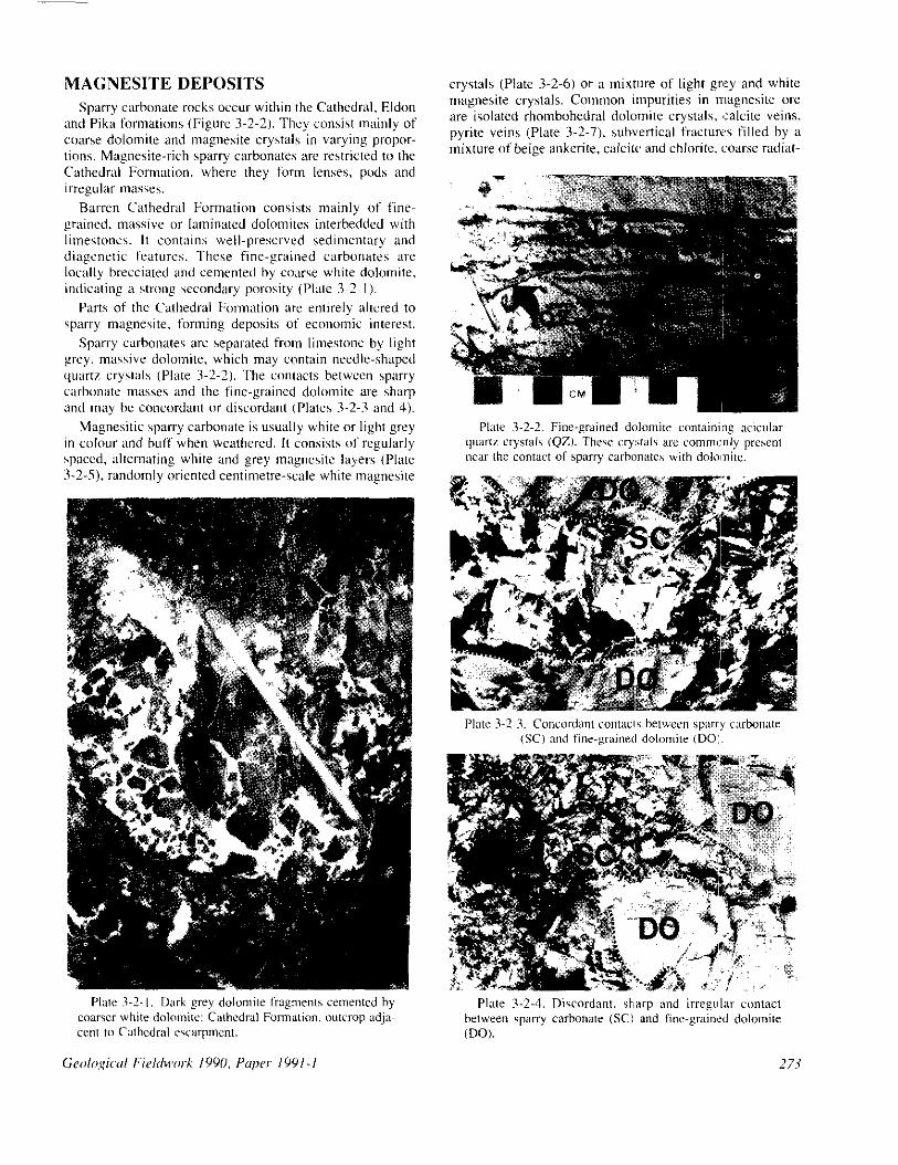
MAGNESITE DEPOSITS Sparry carbonate rocks occur within the Cathedral, Eldon
and Pika formations (Figure 3-2-2). They consist mainly of cwrse dolomite and magnesite crystals in varying propor- tions. Magnesite-rich sparry carbonates are restricted to the Cathedral Formation, where they form lenses, pods and irregular mi~ws.
Barren Cathedral Formation consists mainly of fine- grained, massive or laminated dolomite interbedded with limestones. It contains well-preserved sedimentary and diagcnrtic features. These fine-grained carbonates are locally brrcciated and cemented by conrse white dolomite, indicating ii strong secondary porosity (PIale 3-2-l).
Parts of the Calhedral Formation are entirely altered to sparry magnesite. forming deposits oi economic interest.
Sparry carbonates arc separated from limestone by light grey, massive dolomite, which may contilin needle-shaped quarrr crystals (Plate 3-2-2). The comacfs hetwcen sparry carbonate masses and the fine-grained dolornile are sharp and may hc concordant or discordant IPlates 3-2-3 and 4).
Magnesitic sparry cal-honate is usually white or light grey in colour and huff when weathered. I( consists of regularly spaccd, altrmaring white and grry magnesitc layers (Plate 3-2-S). randomly oriented cenfimetre-scale white magnesite
crystals (Plate 3-2-6) or a mixture of light grt~y and white magnesite crystals. Common impurities in magnesite ore are isolated rhombohedral dolomite crystals, salcite veins. pyrite veins (Plate 3-2-7). suhvertical fractures filled by a mixture of beige ankerite, ulcilt: and chlorite, <coarse radiat-
Plate 3-2-4. Discordant. sharp and irregular urntact between sparry carbonate (SC1 and fine-grairwd dolomite (DO).
273
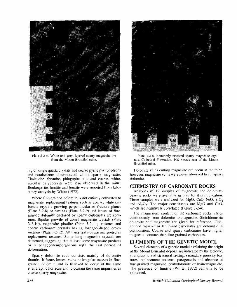
Plate 3-2-5. White and grey, layered “perry magnesite ore from the Mount Brussilof mine.
ing or single quartz crystals and coarse pyrite pyritohedrons and octahedrons disseminated within sparry magnesite. Chalcocite, fersmite, phlogopite, talc and coarse, white. acicular palygorskite were also observed in the mine. Boulangerite, huntite and brucite were reported from labo- ratory analysis by White (1972).
Where fine-grained dolomite is not entirely converted to magnesite. replacement features such as coarse, white car- bonate crystals growing perpendicular to fracture planes (Plate 3-2-8) or partings (Plate 3-2-9) and lenses of fine- grained dolomite enclosed by sparry carbonates are com- mon. Bipolar growths of zoned magnesite crystals (Plate 3-2-10). magnesite pinolite (Plate 3-2-l I), rosettes and coarse carbonate crystals having lozenge-shaped cross- sections (PIa 3-2-12). All these features are interpreted as replacement textures. Some long magnesite crystals are deformed, suggesting that at least some magnesite predates or is penecontemporaneous with the last period of deformation.
Sparry dolomite rock consists mainly of dolomite rhombs. It forms lenses, veins or irregular masses in fine- grained dolomite and is believed to occur at the same stratigraphic horizons and to contain the same impurities as coarse sparry magnesite.
274
Plate 3-2-h. Randomly oriented sparly magnesite crys- tals, Cathedral Formation, 100 mettes cast of the Mount Brussiluf mine.
Dolomite veins cutting magnesite ore occur at the mme. however, magnesite veins were never observed to cut sparry dolomite.
CHEMISTRY OF CARBONATE ROCKS Analyses of I9 samples of magnesite and dolomite-
bearing rocks were available in time for this publication. These samples were analyzed for MgO, CaO, FeO, SiO, and AI,O,. The major constituents are MgO and CaO, wjhich are negatively correlated (Figure 3-2-4).
The magnesium content of the carbonate rocks varies continuously from dolomite to magnesite. Stoichiometric dolomite and magnesite are given for reference. Fine- grained massive or laminated carbonates are dolomitic in composition. Coarse and sparry carbonates have higher magnesia contents than fine-grained carbonates.
ELEMENTS OF THE GENETIC MODEL Several elements of a genetic model explaining the origin
of the Mount Brussilof deposit are indicated by the tectonic, stratigraphic and structural setting, secondary porosity fea- tures, replacement textures. paragenesis and absence of fine-grained magnesite, protodolomite or hydromagnesite, The presence of huntite (White, 1972) remains to be explained.

Plate 3-2-l. Pyrite veinlets cutting magnesite rock: Mount Brussilof mine.
It is suggested that the magnesite postdates early diagenesis of the Cathedral Formation and probably of the Stephen, Eldon and Pika formations as well. Widespread dolomitization and subsequent fracturing and brecciation contributed significantly to an increase in porosity. Some of the fracturing may be due to reactivation of a pre-Cathedral escarpment fault or to a difference in competence of deep and shallow-water sediments during the post-Middle Cambrian tectonic activity. However, most of the breccias were probably produced by a partial dissolution and col- lapse of the carbonate hostrock, caused by incursion of meteoric water or hydrothermal solutions in the manner described by Sangster (1988).
Fluids responsible for crystallization of coarse sparry carbonates reacted with dolomitized, permeable and fract- ured reef facies along the Cathedral escarpment and moved up-dip along the permeable zones. The fluid cooled and evolved chemically along its path due to interaction with dolomitic hostrock. The most important parameters deter- mining the ability of the fluid to increase the magnesium content of carbonate rock are temperature, the mole Ca2+1 mole Mg2f ratio of the solution, the fluid/rock ratio and the salinity of the fluid as well as the permeability, porosity and physical and chemical characteristics of the protolith. The relationship between temperature and mole Ca*+/mole
Geolo,qical Fieldwork 1990, Paper 1991-l
Plate 3-2-K Bipolar growth of sparry carbomtes from a fracture plane in fine-grained dolomite that hosts the Mount Bmssilof deposit.
Mg2+ ratio is illustrated in Figure 3-2-5, high temperature and low mole CaZ+/mole MgZ+ ratio increases the potential of the fluid to convert carbonate:s to magnesia:.
Predictions based on this model suggest that the highest grade magnesite deposits should be located along the edge of the Cathedral escarpment, within the reef facies. Lower grade magnesite deposits and sparry d&mites would be located at a greater distance up-dip from the Cathedral escarpment along the same permeable zones, or adjacent to the escarpment but in the zones of lesser pemteability.
This model conforms well to the field obwvations. It requires confirmation and integration with the results of future petrographic work, geochemical (isotopic, REE, minor and major element) amdysis, fluid inclusion and crystallinity studies. mass balance determinations and fur- ther thermodynamic considerations. Future studies will focus on constraints on the ori,& temperature and com- position of the mineralizing fluid, geochemical gradients, paragenetic relationships and fluid/rock ratios.
ECONOMIC CONSIDERATIONS Several new magnesite showi~ngs that are part of a contin-
uous sparry carbonate belt parallel to the Cathedral escarp-
275
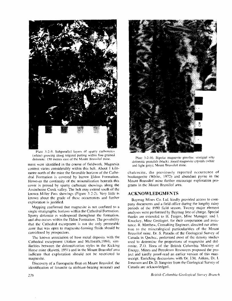
merit were identified in the course of fieldwork. Magnesia content varies considerably within this belt. About I kilo- metre north of the mine the favorable horizon of the Cathe- dral Formation is covered by barren Eldon Formation. However the continuity of the mineralization beneath this cover is proved by sparry carbonate showings along the Assiniboine Creek valley. The belt may extend south of the known Miller Pass showings (Figure 3-2-2). Very littlc is known about the grade of these occurrences and further exploration is justified.
Mapping confirmed that magnesite is not confined to a single stratigraphic horiron within the Cathedral Formation. Sparry dolomite is widespread throughout the formation. and also occurs within the Eldon Formation. The possibility that the Cathedral escuqxnent is not the only permeable zone that was open to magnrsite-forming fluids should he considered by prospectors.
The known association of base metal deposits with the Cathedral escarpment (Aitken and Mcllreath.l9X4), sim- ilarities between the dolomitiration styles in the Kicking Horse mine (Rasetti, I95 I) and in the Mount Brussilof area indicate that exploration should not be restricted to magnesite.
Discovery of a fluorapatite float on Mount Brussilof. the identification of fersmite (a niobium-hearing mineral) and
276
Plate 1-2-10. Bipolar magncsite pinolitr: vestigial silty dolomitic protolith (hlack). zoned magnesitc crystals (white and light grey): Mount Brussilof mine.
chalcocite, the previously reported occurrence of boulangerite (White, 1972) and abundant pyrite in the Mount Brussilof mine further encourage exploration pro- grams in the Mount Brussilof area.
ACKNOWLEDGMENTS Baymag Mines Co. Ltd. kindly provided access to com-
paoy documents and a field office during the lengthy rainy periods of the 1090 field season. Twenty major element analyses were performed by Baymag free of charge. Special thanks are extended to H. Fergen, Mine Manager, and I. Knuckey, Mine Geologist. ft)r their cooperation and assis- tance. R. Matthew. Consulting Engineer, directed our atten- tion to the mineralogical particularities of the Mount Brussilof mine. Dr. S. Paradis of the Geological Survey of Canada in Quebec, performed most of the density studies wed to determine the proportions of magnesite and do- omite. Z.D. Hors of tlte British Columbia Ministry of Energy, Mines and Petroleum Resources proposed the pm ject and kindly proof-read an earlier version of this man- uscript. Enriching discussions with Dr. J.M. Aitken, Dr. I. Jonasson and Dr. D. Sangster from the Geological Survey of Canada are acknowledged.

25
50
011 1.b Id.0
( MCa*‘/ MM;) -
0 5 10 15 20 25 30 ‘70 cao

REFERENCES Aitken, J.D. (1971): Control of Lower Paleozoic Sedimen-
tary Facies by the Kicking Horse Rim. Southern Rocky Mountains, Canada; Bullerin qf Cunodian Pm&urn Geolng~, Volume 19, pages 557.569.
Aitken, J.D. (1989): Birth, Growth and Death of the Middle Cambrian Cathedral Lithosome, Southern Rocky Mountains; Bullrrin r,f’Conodian Petmlmnt GEO/O(C\.. Volume 37, pages 316-333.
Aitken, J.D. and Mcllreath, LA. (1984): The Cathedral Reef Escarpment, a Cambrian Great Wall with Humble Origins: G~0.s. Volume 13, pages 17.19.
Aitken, J.D. and Mcllreath (1990): Comment on “The Bur- gess Shale: Not in the Shadow of the Cathedral Escatp merit”; Geoscience Canada, Volume 17, pages 111-115.
Coope, B.(l987): The World Magnesia Industry; Indrrswkd Mineds, Number 223, pages 2 l-3 I.
Duncan, L.R. (1990): Magnesite; Mining Eqginewing, Vol- ume I9 I, Number 6. page 569.
Fritz, W.H. (1990): Comment: In Defence of the Escarp- merit near the Burgess Shale Fossil Locality: Gcn- s&we Cunada, Volume 17. pages I Oh- I IO.
Grant. B. (1987): Magnesite, Brucite and Hydromagnesite Occurrences in British Columbia; B.C. Minisrr~ of Energy, Mines and Perroleum Kesourws, Open File 1987.13, 68 pages.
Leech, G.B. (1965): Kananaskis Lakes, W l/2 Area; in Report of Activities, May to October, 1965; Grologi- cd SWvey of Canada, Paper 66 I, pages 65-66.
Leech, G.B. (1966): Kananaskis Lakes; Geologirnl Suwey of Canada, Open File 634.
Ludwigsen, R. (1989): The Burgess Shale : Not in the Shadow of the Cathedral Escarpment; Geoscience Canada, Volume 16, pages 139.154.
Ludwigsen. R. (1990): Reply to Comments by Fritz, and Aitken and Mcllreath; Geoscience Canada, Volume 17, pages 116.118.
MacLean, M.E. jl988): Mount Brussilof Magnesite Project. Southeast British Columbia (82113E); B.C. Minist!:~ ifl Ene/;y.v, Minrs md Pen-ol~um Rmnurces, Geological Fieldwork 1988, Paper 1989.1, pages 507.510.
Mcllreath, 1.A and Aitken. J.D. (1976): Yoho/aminim (Mid- dle Cambrian) Problematic Calcareous Sediment- stabilizing Organism: Gwlogical A.ssok~fion of Cm- ada, Program with Abstracts, 1976 Annual Meeting, page 84. page 84.
Rasetti, F. (1951): Middle Cambrian Stratigraphy and Fauna Rasetti, F. (1951): Middle Cambrian Stratigraphy and Fauna of the Caadian Rocky Mountains; Smirhsoniurl Mis- of the Caadian Rocky Mountains; Smirhsoniurl Mis- ndlmeorrs Colkriom. Volume 1 16. Number 5, 277 ndlmeorrs Colkriom. Volume 1 16. Number 5, 277 pages.
Rosenberg. P.E., Burt, D.M. and Holland, H.D., (1967): Calcite - Dolomite - Magnesite Stability Relations in Solutions: the Effect of Ionic Strength; Grochimica (,f Cosmochimica Acra, Volume 3 I, pages 39 l-396.
Sangster, D.F. (1988): Breccia-hosted Lead-Zinc Deposits in Carbonate Rocks; in Paleocarst, N.P. James, and P.W. Choquette, Editors, Sprinp--l/w/q NPM. York Inc., pages 102-I 16.
Schultes. H.B. (1986): Baymag High Purity MgO from Natural Magnesite; Cawarlrun Institute $ Mining and M~rallqy, Bulletin, May 1986, pages 43-47.
Stewart, W.D. (1989): A Preliminary Report on Stratigraphy and Sedimentology (Middle to Upper Cambrian) in the Zone of Facies Transition, Rocky Mountain Main Ranges, Southeastern British Columbia; in Current Research, Pan D, Geol~,~ix~l Survey of Cnnada, Paper 89.ID, pages 61-68.
Wilson, E.M., Hardie, A.L. and Phillips, O.M. (1990): Dol- omitiration Front Geometry, Fluid Flow Patterns, and the Origin of Massive Dolomite: The Triassic Latemar Buildup, Northern Italy; American Journal of Science. Volume 290, pages 741.796.
White, G.P.E. (1972): Mineralogy of the Baymag Mines Ltd. Magnesite Prospect, South Kootenay Area, B.C.; Acrers Wesrern Limited, unpublished report, 17 pages.
278 British Columbia Geological Survey Branch