geomaticsworld 2014
TRANSCRIPT
GeomaticsWorld JANUARY / FEBRUARY 2014
Multicopter chartsthe way for new
hyperspectral sensor
Esri’s UrbanObservatory into
22 world cities
Scan to BIM helpsupdate top Beverly
Hills Mall
Rain doesn’t stopmerging technologies
at the Oval
Lost African heritagepreserved by 3D
scanning
Issue No 2 : Volume 22
Surveying for geographical and spatial information in the 21st century
FREE DIGITAL SUBSCRIPTION FOR PROFESSIONAL SURVEYORS see page 3

BUSINESS 2014BUSINESS DESIGN CENTRELONDON UK 28–29 MAY
A brand new geospatial event for everyone involved in the gathering, storing, processing and deliveringof geospatial information.
Incorporating:
· A world class exhibition attracting the leading service
providers and suppliers of geospatial technology
· An innovative conference presenting the latest industry
advances for all those working with spatial data
· A workshop and demonstration programme offering
buyers a hands-on experience and providing in-depth
knowledge of the latest products and services
For more information on the event visit
www.GeoBusinessShow.com
Call for PapersDEADLINE29th January 2014Submit abstracts online:www.GeoBusinessShow.com
GEO Business
@geobusinessshow
Organised by: In collaboration with:
EMPOWERING GEOSPATIAL INDUSTRIES

Copy dates are: Editorial: 10 February Advertising: 14 FebruaryNN EE XX TT II SS SS UU EE The next issue of GW will be March / April 2014.
p.05 Editorialp.06 Newsp.08 Calendarp.09 Chair’s Columnp.10 Undercurrents
p.28 Policy Watchp.32 Down Undercurrentsp.33 Products & Servicesp.34 Recruitmentp.35 Classified
Geomatics World is published bi-monthly by PV Publications Ltd on behalf of the Royal Institutionof Chartered Surveyors Geomatics Professional Groupand is distributed to group members and othersubscribing professionals.
Editor: Stephen Booth
Technical Editor: Richard Groom
News Editor: Hayley Tear
Advertising & Subscriptions: Sharon Robson
Editorial BoardPat Collins, Richard Groom, Alan Haugh, James Kavanagh, Professor Jon Mills, Dr Stuart Robson, Dr Martin Smith
Overseas SourcesRoy Dale – New ZealandNick Day – USA
Editorial and advertising:e-mail: [email protected]: www.pvpubs.comT: +44 (0) 1438 352617F: +44 (0) 1438 351989
Mailing: PV Publications Ltd2B North RoadStevenage, Hertfordshire SG1 4ATUnited Kingdom
Material to be PublishedWhile all material submitted for publication will behandled with care and every reasonable effort is madeto ensure the accuracy of content in Geomatics World,the publishers will have no responsibility for any errorsor omissions in the content. Furthermore, the viewsand opinions expressed in Geomatics World are notnecessarily those of the RICS.
Reprints: Reprints of all articles (including articlesfrom earlier issues) are available. Call +44 (0)1438352617 for details.
Advertising: Information about advertisement rates,schedules etc. are available in the media pack.Telephone, fax or write to PV Publications.
Subscriptions: Yearly subscription (six issues) is £45(UK) £49 (worldwide). For more details, includingspecial offers, go to: www.pvpubs.comNo material may be reproduced in whole or in partwithout written permission of PV Publications Ltd.© 2014 ISSN 1567-5882
Printing: The Manson Group, St Albans, UK
January / February 2014 Geomatics World 03
Contentsp.12 Scan to BIM: the Beverley Center Shopping Mall
The Mollenhauer Group has been busy capturing one of the world’s largest andmost exclusive malls ahead of a redesign. Chris Gray and Jenny Clark report.
p.16 Web GIS is set to transform cartographyGW reports from a lecture given by GIS guru Jack Dangermond to The BritishCartographic Society on the changes ahead as GIS moves to the web.
p.18 No stoppage for Topcon’s rainy day at The OvalThe Hybrid Roadshow was a chance for GW’s Richard Groom to find out more aboutTopcon’s MAGNET cloud and other new merged technologies.
p.20 Hyperspectral for agriculture takes to the skyA German company has developed a light-weight hyperspectral scanner formounting on a multi-copter and suitable for agricultural applications.
p.22 Leica Geosystems moveA busy two days in December provided the opportunity for several hundredcustomers to view the company’s new EMEA headquarters.
p 25 Galilleo MastersAn app that tracks athletes performance in real time is a 2013 winner.
p.26 Scan2BIM or Scan2Model?The Severn Partnership has been creating a BIM of RICS headquarters.
p.27 Great changes can happen quickly?Yes they can, believes Michael Barrett Award winner Gavin Adlington.
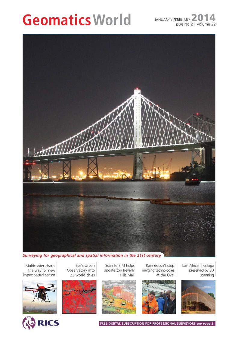
COVER STORYThe new East Span ofthe San Francisco-Oakland Bay Bridgecost $6.4bn, makingit the world's mostexpensive bridgeaccording to theGuinness Book ofWorld Records. Formore turn to page 30.© photo Nick Day.
PV Publications Ltd2B North Road,Stevenage, Herts SG1 4ATT: +44(0)1438 352617W: www.pvpubs.com
GW: get the electronic edition firstReaders can receive a free electronic link by email to the latest issue of GW before the print editionis published. Email your request to [email protected] (please note that if you are notalready a subscriber or member of RICS or IIS, you may be asked to complete a digital form so thatwe can validate your application). If you would also like to receive the printed edition you cansubscribe at www.pvpubs.com. Please note that RICS overseas members need to advise us if they wantto continue receiving the printed edition by opting in at: http://www.pvpubs.com/OverseasRICS
Note: the electronic version can now be downloaded as a PDF.
GW's Digital ExtrasGW's Digital Extras You can read more articles from this issue online including:The CyArk 500 Challenge a not-for-profit organisation plans to capture 500 world heritage sitesin high accuracy 3D. GW’s Richard Groom reports from the launch at the Tower of London.
http://www.pvpubs.com/archives.php?titleid=1&issueid=220Please note that this link is free of any restrictions to readers but does not allow accessbeyond the currency of this issue or to the archives.For a great deal on subscriptions and access to over ten years of articles go to:
www.pvpubs.com
Did you get your FREE copy of Showcase? RICS members in the UK areentitled to receive a free copy upon registration or request. Just drop us anemail with your full postal address and we’ll pop a copy in the post toyou. Overseas readers can still view the latest issue by going to:http://www.pvpubs.com/archives.php?titleid=1&issueid=217
Engineeringsurveyingshowcase2013 ISSUE TWO

Capture everything now,
measure later
tel UK: 0845 603 1214 IRE: 01 456 4702
With familiar Trimble
workflows and the push of
a button, you can capture
60mp panoramic images
for use with your traditional
datasets allowing you to take
photogrammetric measurements
back at the office.
The Trimble V10 Imaging Rover
with Trimble VISION technology
can be used either standalone,
or seamlessly integrated with the
Trimble R10 GNSS receiver and
Trimble S-series total stations.
A new standard is set for
positioning applications.
Book your demonstration
www.trimbleimaging.co.uk
2013-GW-FP-V10.indd 1 25/10/2013 12:48:31
Editorial
January / February 2014 Geomatics World 05
Measured Building Surveys, BIM and FacilityManagement. This is bound to be a recurrent topicduring the year and we shall try to keep you informedon the progress of RICS’s own BIM. But there is muchmore to talk about and to share best practice. Willcheaper scanners be a trigger for as-built BIMs?
EDM & Optics vs. Digital Cameras. This is anopportunity to look at some of the latest data capturetools that rely on photogrammetric solutions as well asthe integration of scanning technology in total stations.
Maps, Land Registration and Surveys: can they bereconciled? This is a thorny topic for many practical fieldsurveyors. Your views please.
Measuring and monitoring the seabed: new toolsfor new datasets. Time to get wet.
Laser scanners: is there anything they can’t do? Tell usabout your apps and what works and what pushes theenvelope just a bit too far.
Data: where to keep it? On your desktop? In yourpocket? Or in the cloud? Views on managing andkeeping data secure please.
Colliding worlds: remaining professional in a privatisedworld where profit, sales targets and PR are the drivers.
GIS and mapping in geopolitics. Mapping is often thefirst resource needed in a time of crisis, whether by themilitary, NGOs or the media. But do out-of-date or poorlyscaled maps influence opinion and critical decision making?
Welcome to 2014, a year for whichmuch is promised. The world economyis showing signs of improvement, led
by the US. While here in the UK the coalitiongovernment has persuaded itself and most ofthe media that our economy too is improving.We shall see. Closer to surveying and geomaticswe have a new event to look forward to at theend of May in London. GEO Business could be areal game-changer for our business but itrequires the engagement of individuals as wellas the professional and other organisations thatoperate across the geospatial sector. Moredetails at http://geobusinessshow.com/ For theoffshore sector there is Oceanology to lookforward to in March(http://www.oceanologyinternational.com/). Plentyof opportunities there.
Two topics are bound to run through GWthis year: BIM and unmanned aerial systems(UAS). Both are in this issue, with BIM especiallymaking a strong presence throughMollenhauer’s work at the Beverley Hills Center(page 12). For UAS (aka UAVs) we may yet haveto bow to popular media and call them dronesso our clients know what we’re talking about.
Reducing the size of sensors is helpinggrow the market for UAS. We have alreadyseen a multicopter with a Faro scanner aboardand now the development by Cubert of alight-weight hyperspectral sensor is a sign ofopportunities to come in the agricultural andland management sectors (page 20).
In early December last year came the sadnews that author Andro Linklater had died, justas his latest book was published in the US.Andro’s previous book on Measuring Americawas a bestseller, explaining lucidly theconnection between the emergence of amodern economy and standards ofmeasurement. His latest work, Owning theEarth focuses on how individual landownership has transformed economies overthe last quarter millennia, while economiesthat have kept communal or monarchicalsystems have languished. We shall bring you areview in the next issue of GW.
Finally, here are some of the themes wewant to follow over the coming year in GW.Can you contribute with an article? Any styleis welcome – a short news story, a brief casestudy or a longer paper. Drop me a line [email protected]
GIS & Geomatics: the role of geomatics in GIS.Perhaps Jack Dangermond’s lecture on GIS & WebCartography (page 18) could be a starting point.
The year aheadoffers betteropportunities thanwe’ve had since thefinancial crash of2008. But it doesneed members toengage in eventsand in their journal.Tell us how we canimprove and howyou can contributeto the editorialagenda.
Promising agenda for 2014
The editor welcomes yourcomments and editorialcontributions by e-mail: [email protected] by post:Geomatics WorldPV Publications Ltd2B North RoadStevenageHerts SG1 4ATUnited Kingdom
TEN YEARS AGOGW JANUARY/FEBRUARY 2004
A striking front cover of crop marks in the shape ofgiant human feet heralded the first issue of 2004.Built by Erna Reich, the marks were captured fromspace by the Ikonos satellite. In other spacebornenews, the Russian Federation had just launchedthree new satellites for the Glonass constellation,affirming their commitment to the system.
The issue featured forensics with articles by twoAustralians: the late Ian Harley and Prof John Fryer.Spencer Chainey of the Jill Dando Institute of CrimeScience offered the GIS perspective on crime.
Once colloquially known as “Hollwey’s Academy”after teacher John Hollwey, the University of EastLondon was celebrating 50 years of educatingsurveyors, first as the South West Essex College, thenNorth East London Polytechnic before universitystatus was granted in 1992.
In the news was the late Rear Admiral Steve Richiewho had just opened his eponymous building at theTaunton headquarters of the UK Hydrographic Office.
Stephen Booth, Editor
NEWS
06 Geomatics World January / February 2014
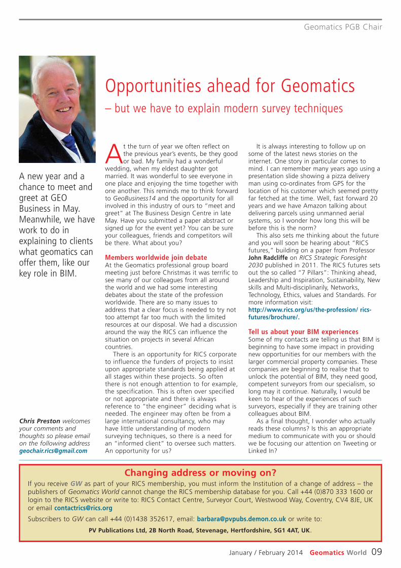
Carl Pulfrich Award 2013Hexagon has announced that theCarl Pulfrich Award 2013 forinnovation in geodesy, photo -grammetry and earth sciences hasbeen awarded to Prof Dr NicholasC. Coops, Vancouver, and Prof DrNorbert Haala, Stuttgart.Professor Coops has madeoutstanding contributions tosolving mapping problems inbiodiversity, especially in usingremote sensing technologies forvegetation growth and canopycharacterisation. Professor Haalahas made huge impacts to furtherdevelop photogrammetricrestitution, in particular in theareas of 3D city modelling, denseimage matching and use of UAVs.
Intel Capital invests inDotProductDotProduct’s handheld scanningdevice has received seed fundingto accelerate development andsales growth. “3D reconstructionwill change the way we capturethe world, from objects, peopleand places,” said Mark Yahiro,managing director of newbusiness for Intel’s PerceptualComputing Group. “DotProduct is
on the forefront of the next waveof computing and we are excitedto see their solutions come to themarket.” DotProduct softwareruns on widely available, low-costtablets; uses off-the-shelf 3Dcamera sensors and connects towell-established design,engineering and capital assetmanagement solutions.
Topcon donates to DITTopcon has equipped twolaboratories at the Dublin Instituteof Technology (DIT) with state-of-the-art equipment. The donation,worth more than $500,000, hasbeen made as part of thecompany’s education partneringinitiative. Ray O’Connor, a DITgraduate, president and CEO ofTopcon Positioning Systems (TPS),and senior managing executiveofficer with Topcon Corporation,formally launched the twotechnology labs for surveying andoptometry students onWednesday, October 23, at twoDIT campuses.
Leica recertifiesThe Quality and EnvironmentalManagement System of Leica
Geosystems AG has beenrecertified to ISO 9001:2008 andISO 14001:2004 compliance forthe development, manufacture,distribution, support and serviceof products, precision tools andsystems for geomatics, industrial,machine control and constructionapplications with zero non-conformities. With therecertification, Leica Geosystemscombines its previous certificatesunder one global certificationscheme. “The transition to aglobal certificate is an importantstep to further align our internalprocesses globally,” said GerhardHeimlinger, director qualitymanagement of LeicaGeosystems.
Unravelling Earth’smagnetic fieldThe Earth’s magnetic field can bethought of as a huge bubble,protecting us from cosmicradiation and charged particlesthat bombard the planet in ‘solarwinds’. Without this protectiveshield, the atmosphere as weknow it would not exist,rendering life on Earth virtuallyimpossible. Even as it is, strongsolar storms have the potential tocause power and communicationblackouts, and also to damagesatellites orbiting Earth.
‘Swarm’ is the EuropeanSpace Agency’s first constellationof satellites to advance ourunderstanding of how the Earthworks. Harnessing European andCanadian technologicalexcellence, the three Swarmsatellites will measure preciselythe magnetic signals that stemfrom the Earth’s core, mantle,crust and oceans, as well as itsionosphere and magnetosphere.
The geomagnetic field modelsresulting from the mission willprovide new insights into theEarth’s interior. The data, alongwith measurements ofatmospheric conditions aroundthe orbiting satellites, will furtherstudies into the Earth’s weakeningmagnetic shield, space weatherand radiation hazards.
Tracking a giant icebergProfessor Grant Bigg from theUniversity of Sheffield has beenawarded a £50,000 grant fromthe Natural Environment
Research Council (NERC) for asix-month project to track themovements and melting of agiant iceberg the size ofSingapore as it moves throughthe Southern Ocean. The researchcollected by tracking itsmovement, and modelling itstrajectory and melting will beused by the shipping industry andassociated agencies currentlyusing the Southern Ocean toprovide more accurate icewarnings.
Realising the potentialof mobile mapping3D Laser Mapping has signed areseller agreement with OrbitGeospatial Technologies to turnraw mobile mapping data intomanageable, easy to use, GIS-integrated content that empowerscompanies to utilise mobilemapping information across anorganisation. Orbit’s mobilemapping products allow for theviewing and management of datacaptured by systems such asStreetMapper. There are tools formeasurement, feature extraction,GIS integration and overlay,organisation wide deployment andsharing as well as publishing,embedding and processing ofmobile mapping content.
Situational AwarenessstandardA key element to efficientlyhandling any emergency oroperation is a common“situational awareness”. Theability to share the samecommon operational picturebetween all respondents iscritical. The Open GeospatialConsortium (OGC) answer toaddress this paradigm is the OWSContext specification. In a crisis,when time is of the essence, anemergency responder, a soldier ora geospatial analyst, can create aview of the situation by pullingtogether feature data, map andimagery data. This data can besupplemented with text orgraphics to point out areas ofinterest. All of this can then becaptured in an OWS Contextdocument in order to share acommon assessment of asituation with others setting theframework from which alloperations will then have a
Late last year Maptek was asked to survey Mount Panorama inNew South Wales for a video game. An I-Site 8800 scanner wasmounted on a vehicle with a GPS unit to conduct the surveys.Stop-go scanning allowed the operator to remain in the vehicle,while scans were observed every 100 metres. The integratedcamera in the I-Site 8800 captured simultaneous photographs,allowing scans to be overlaid by photo pixels for enhanced reality.Game developers required a four-sided polygon to model the trackdata. Point cloud data was exported from I-Site Studio softwarefor processing. Being able to obtain a high intensity laser returnfrom the black asphalt proved to be the biggest benefit of usingthe I-Site system. The finished game was released in November sogamers can now experience every bump on the track, as if theywere driving it themselves.
Maptek models for gamers

NEWS
January / February 2014 Geomatics World 07
common understanding. OGC hastherefore adopted the OGC OWSContext Conceptual Model andthe associated OGC OWS ContextATOM Encoding as adoptedstandards, along with schemasand examples.
Keep current, licensedand legalAn Ordnance Survey study carriedout across Great Britain revealsthat approximately 45% of allplanning application mapssubmitted are either unlicensedor incorrectly displayed. This newsfollows an OS study that showed40% of land and propertyprofessionals, including civilengineers, architects, propertylawyers, developers and housingassociations, could be using outof date or unlicensed mappinginformation in their work.
Using out of date or unlicensedmapping data carries the risk ofmaking decisions based onincorrect information, says OS, andmeans land and propertyprofessionals who do this may notbe giving their colleagues andclients the full and accuratepicture. As well as having thepotential for creating delays,conflict and increased projectcosts, the use of unlicensedcopyright mapping data is alsoagainst the law. Furthermore, if apractice is a small business, theowners or directors are more likelyto know of the unlicensed use,which is more serious in law.Under such circumstancesprofessional indemnity insurancecould be put at risk.
Innovation programmefor East MidlandsA new project led by TheUniversity of Nottingham isaiming to place innovation fromthe East Midlands at theforefront of the internationalspace industries. The SatelliteApplications Business InnovationProgramme will be targeted atovercoming the challenges oftaking innovative academicresearch from universitylaboratories to the marketplace.
The programme at theUniversity’s GNSS ResearchApplications Centre of Excellence(GRACE), a knowledge transferand business engagement unit
based at the University’sNottingham Geospatial Institute(NGI), will also connect localbusinesses in the region to worktaking place at the nationalSatellite Applications Catapult,based in Harwell in Oxfordshire,which centres on thedevelopment and commercialexploitation of space andsatellite-based products, servicesand applications.
Paul Bhatia, general managerat GRACE, said: “The globalspace sector is predicted to growto £400 billion by 2030, with theGovernment driving the UK’shuge ambition to increase itsshare of that from the current£7bn to £40bn.”
Among the challenges whichthe programme will beaddressing will be tackling theso-called “valley of death” —the gap which has arisenbetween the development oftechnologies through academicresearch and the ability totransform it into an end resultwhich is market ready. Productdevelopment is a costly businessand it can often be difficult toattract businesses willing togamble on its potential success.
Leica HDS SymposiumLeica held its annual HDS users’symposium on 4th December at itsnew offices in Milton Keynes.Seventy-eight delegates took partin the event which covered arange of topics presented by users,including BIM, scanning surveys ofships, industrial plant and heritageand presentations on calibrationand verification procedures atLeica’s factory, the new check andadjust feature on the P20 scanner– shortly to be extended to theC10, new licensing procedures forCyclone, and getting the most outof Truview, which were presentedby Leica staff. Participants werealso treated to a sneak preview ofa series of TV programmes onscanning for heritage which is dueto be aired on the NationalGeographic channel in the newyear.
Satellite-derivedbathymetric mapsProteus FZC, has deliveredaccurate bathymetric and seafloorclassification maps for a joint UK-
France amphibious militaryexercise on Corsica. In the pilot,managed by the UK HydrographicOffice (UKHO), Proteus partneredwith DigitalGlobe to deriveaccurate bathymetricmeasurements and identify fourseabed types to a depth of 12metres from multispectralsatellite imagery without groundcontrol. The vertical accuracy ofthe bathymetry was verified at10-15% of water depth. “Wecompleted the Corsica coastalmarine mapping project in aboutone-tenth the time and cost oftraditional sonar or LiDAR,” saidProteus CEO David Critchley.For more information see Jan/Febissue of Hydro International.
BRIEFS
The Association forGeographic Information (AGI)is the latest organisation toback the GEO Business event,which takes place in London28-29 May 2014. As acollaborator of the event AGIjoins other leading industryorganisations including theChartered Institution of CivilEngineering Surveyors (ICES),the Royal Institution ofChartered Surveyors (RICS)and The Survey Association(TSA).
Ugandan daily, New Vision reportsthat the German government hassigned an agreement with Ugandato facilitate the demarcation of itsborders with Rwanda. Theagreement was signed in Kampalaat a ceremony where Germanambassador Klaus DieterDüxmann handed over anassortment of equipment toUgandan Lands, Housing andUrban Development ministerDaudi Migereko. The project isbeing undertaken under theAfrican Union Border Programme.The programme runs under themotto ‘from barriers to bridges’which underlines thatinternational borders should notbe perceived as barriers but ratheras bridges. Visit:www.newvision.co.ug
Ordnance Survey Internationalhas signed a five-year specialistadvisory framework agreementwith the Survey and LandRegistration Bureau (SLRB) ofthe Kingdom of Bahrain. Theagreement provides anopportunity for bothorganisations to work togethercollaboratively on a number ofprojects, the first of which willbe the development of a newlong-term strategy, which willsupport SLRB in continuing todevelop its role as the authori -
Aworth –50 years insurvey
Leica Geosystems has presented a piece of heritage equipment,to Aworth Survey Consultants, to mark the company’s 50 years inbusiness. A surprise presentation of a specially engraved Wild/Leica Zenith & Nadir optical plummet, circa 1963, was made toAworth’s managing director John Witherden (above left) during agroup discussion meeting of The Survey Association (TSA) at theImperial War Museum, Duxford. Leica Geosystems’ UK direct salesmanager Tim Badley, who made the presentation, said, “It is agreat pleasure to be able to congratulate John personally onsuccessfully leading Aworth to their 50th year and to wish themmany more years of success. It seemed altogether appropriate topresent Aworth Survey Consultants with a piece of Wild/ Leicasurvey history to mark this milestone.”

NEWS & PEOPLE
08 Geomatics World January / February 2014
tative cadastral and mappingauthority for the Kingdom.
The UK’s Department forEnvironment, Food and RuralAffairs (Defra) has designated 27areas around England’s coast asmarine conservation zones(MCZs). Also announced are twofurther phases of MCZs to bedesignated over the next threeyears. Factsheets for the 22inshore MCZs are available fromNatural England and factsheetsfor the five offshore sites areavailable from the Joint NatureConservation Committee.
Bluesky is supporting a £1million three-year researchproject into the potential costsand benefits of solar energy inthe UK. Funded by theEngineering and PhysicalSciences Research Council(EPSRC), PV2025 aims to answera number of questions relatingto the production of solarenergy through photovoltaicsacross the UK and howgeography, legislation and
social factors might impact onthe costs and benefits to UK Plc.
The Marine ManagementOrganisation (MMO) has grantedpermission to the NationalRenewable Energy Centre (Narec)to build a grid-connected,99.9MW demonstration offshorewind project off the coast ofBlyth in Northumberland. Theproject is the first large-scale,deep water demonstration site inthe UK to be granted bothoffshore permits and onshoreconsent. It will provide a facilityfor industry to test next-generation offshore windtechnology in realistic conditionsbefore commercial production.
GNSS developer AltusPositioning Systems has joinedthe Esri Partner Network, aglobal community ofcompanies developing andselling GIS using the ArcGISplatform. The network hasmore than 1,800 organisationsdoing business in nearly 80countries around the world.
Trinder leads SSSIAustralasia’s Surveying andSpatial Sciences Institute (SSSI)has welcomed Emeritus ProfessorJohn Trinder, as its newPresident for the term 2013-15,having been on the board of SSSIsince 2011. Prof Trinder,graduated from the University ofNew South Wales (UNSW) in1963 and has been employed byUNSW since 1965. He was thePresident of the InternationalSociety for Photogrammetry andRemote Sensing (ISPRS) from2000 to 2004.
Loughran joins BlueskyBluesky has appointed RobertLoughran as international salesmanager. Previously with Fugro,Infoterra and BKS Surveys, hejoins at an exciting time as theLeicestershire company looks toexpand its global operation,maximising on its investment inaerial survey equipment.
O’Connor joinsHall of FameRay O’Connor, president andCEO of Topcon PositioningSystems, and senior managing
executive officer with TopconCorporation, was inducted intothe Association of EquipmentManufacturers (AEM) Hall ofFame during its 2013 annualconference held in earlyNovember. The award recognisesand celebrates outstandingindividuals in the off-roadequipment industry, and theirlegacy of innovation, service andleadership.
“I am extremely humbled bythe award”, said O’Connor. “Thishonour can’t be achieved by anindividual but only by a team ofpeople with a passion tosucceed. The team of employeesand distributors we have atTopcon exemplifies this.”
Holcroft & Kedar join OSChris Holcroft and John Kedarhave joined Ordnance SurveyInternational as directors ofstrategic business development.Holcroft will be responsible fordeveloping long-term partner -ships with stakeholders in theMiddle East while Kedar will befocusing on the successfulrelationship with the Kingdom ofBahrain.
Events Calendar 2014Events Calendar 2014• SEMINARS • CONFERENCES • EXHIBITIONS • COURSES• SEMINARS • CONFERENCES • EXHIBITIONS • COURSES
Defence Geospatial Intelligence 201421-23 January 2014, QEII ConferenceCentre, London, UK Contact:www.wbresearch.com/dgieurope/home.aspx
GeoUtilities 201428-29 January 2014, London, UK.Contact:www.geospatialutilities.com
RICS BIM Conference12 February 2014, London, UK.Contact: www.rics.org/uk/training-events/conferences-seminars/rics-bim-conference/london/
International LiDAR MappingForum (ILMF)17-19 February 2014, Hyatt RegencyDenver, Colorado Convention Center,Denver, Colorado, USA. Contact:www.lidarmap.org/international
Esri Partner Conference 20148-11 March 2014, Palm SpringsConvention Centre, CA, USA.Contact:www.esri.com/events/partner-conference
Esri International DeveloperSummit 201410-13 March 2014, Palm SpringsConvention Centre, California USA.Contact:www.esri.com/events/devsummit
Oceanology International 201411-13 March 2014, London, UK.Contact:www.oceanologyinternational.com
SPAR International 201414-17 April 2014, The Broadmoor,Colorado, USA.Contact:www.sparpointgroup.com/International
INTERGEO Eurasia28-29 April 2014, Istanbul, Turkey.Contact:www.intergeo-eurasia.com
GEO Business 201428-29 May 2014, Business DesignCentre, London, UK.Contact:http://geobusinessshow.com
We welcome advance details of events likely to be of interestto the Geomatics community. Please send details to:
e d i t o r @ p v p u b s . d e m o n . c o . u k
In November, a hundred and twenty leading members of greaterLondon’s geospatial community gathered at the Dover StreetRestaurant in Mayfair for the London Survey Dinner, hosted bythe survey equipment company, SCCS. For the first time at theevent SCCS made three awards.
The Most Innovative Use of New Technology award waspresented to Nigel Drayton and Ian Campbell from Costain’s LondonPower Tunnels project for their early adoption of the Leica MS50Multi Station for monitoring the thickness and profile of the sprayedconcrete lining being applied on the project. The TechnicalCollaborator of the Year award went to Steven Thurgood of SkanskaCivil Engineering for his approach to developing, communicating andsharing best practice whilst working with his Costain Skanska JVengineering surveying team at Crossrail Paddington C405. SCCSPartner Project of the Year was awarded to Michael May (above leftreceiving the award from SCCS’ sales & marketing director David Price),representing the Victoria Station Upgrade project currently beingundertaken by Taylor Woodrow BAM Nuttall JV.
Awards atLondonSurveyDinner
January / February 2014 Geomatics World 09
Geomatics PGB Chair
Changing address or moving on?If you receive GW as part of your RICS membership, you must inform the Institution of a change of address – thepublishers of Geomatics World cannot change the RICS membership database for you. Call +44 (0)870 333 1600 orlogin to the RICS website or write to: RICS Contact Centre, Surveyor Court, Westwood Way, Coventry, CV4 8JE, UKor email [email protected]
Subscribers to GW can call +44 (0)1438 352617, email: [email protected] or write to:
PV Publications Ltd, 2B North Road, Stevenage, Hertfordshire, SG1 4AT, UK.
At the turn of year we often reflect onthe previous year’s events, be they goodor bad. My family had a wonderful
wedding, when my eldest daughter gotmarried. It was wonderful to see everyone inone place and enjoying the time together withone another. This reminds me to think forwardto GeoBusiness14 and the opportunity for allinvolved in this industry of ours to “meet andgreet” at The Business Design Centre in lateMay. Have you submitted a paper abstract orsigned up for the event yet? You can be sureyour colleagues, friends and competitors willbe there. What about you?
Members worldwide join debateAt the Geomatics professional group boardmeeting just before Christmas it was terrific tosee many of our colleagues from all aroundthe world and we had some interestingdebates about the state of the professionworldwide. There are so many issues toaddress that a clear focus is needed to try nottoo attempt far too much with the limitedresources at our disposal. We had a discussionaround the way the RICS can influence thesituation on projects in several Africancountries.
There is an opportunity for RICS corporateto influence the funders of projects to insistupon appropriate standards being applied atall stages within these projects. So oftenthere is not enough attention to for example,the specification. This is often over specifiedor not appropriate and there is alwaysreference to “the engineer” deciding what isneeded. The engineer may often be from alarge international consultancy, who mayhave little understanding of modernsurveying techniques, so there is a need foran “informed client” to oversee such matters.An opportunity for us?
A new year and achance to meet andgreet at GEOBusiness in May.Meanwhile, we havework to do inexplaining to clientswhat geomatics canoffer them, like ourkey role in BIM.
Opportunities ahead for Geomatics– but we have to explain modern survey techniques
Chris Preston welcomesyour comments andthoughts so please emailon the following [email protected]
It is always interesting to follow up onsome of the latest news stories on theinternet. One story in particular comes tomind. I can remember many years ago using apresentation slide showing a pizza deliveryman using co-ordinates from GPS for thelocation of his customer which seemed prettyfar fetched at the time. Well, fast forward 20years and we have Amazon talking aboutdelivering parcels using unmanned aerialsystems, so I wonder how long this will bebefore this is the norm?
This also sets me thinking about the futureand you will soon be hearing about “RICSfutures,” building on a paper from ProfessorJohn Radcliffe on RICS Strategic Foresight2030 published in 2011. The RICS futures setsout the so called “7 Pillars”: Thinking ahead,Leadership and Inspiration, Sustainability, Newskills and Multi-disciplinarily, Networks,Technology, Ethics, values and Standards. Formore information visit:http://www.rics.org/us/the-profession/ rics-futures/brochure/.
Tell us about your BIM experiencesSome of my contacts are telling us that BIM isbeginning to have some impact in providingnew opportunities for our members with thelarger commercial property companies. Thesecompanies are beginning to realise that tounlock the potential of BIM, they need good,competent surveyors from our specialism, solong may it continue. Naturally, I would bekeen to hear of the experiences of suchsurveyors, especially if they are training othercolleagues about BIM.
As a final thought, I wonder who actuallyreads these columns? Is this an appropriatemedium to communicate with you or shouldwe be focusing our attention on Tweeting orLinked In?

Undercurrents
10 Geomatics World January / February 2014
While Marconi is attributed with being thefather of radio transmission it was down toReginald A. Fessenden (1866-1932) that wecan hear speech on the radio waves. He wasthe first to devise a complete system ofwireless transmission and reception. By usingamplitude modulation (AM) of continuouselectromagnetic radio waves he was able totransmit speech and music instead of just thedit-dit, da-da of Morse code. In 1906 heannounced to a waiting world that just beforemidnight on Christmas Eve ships and otherswith wireless sets should tune in. What theyheard was not only human speech for the firsttime but a beautiful recording of Ombra MaiFu from Handel’s opera Xerxes. From then onit was only a short time before the first radiostations were broadcasting to the world.
Winchester so loves America that he hasbecome a US citizen. He certainly has a greatrepertoire of anecdotes about the place.During one of his early visits he set out (onbehalf of his English publishers) to visit everytown in the US called Paradise. There areeighteen of them. In Paradise Missouri he meta Mr & Mrs Angel who invited him into theirhome and fed him cherry pie. He thought itwas indeed the nearest he would ever get toheaven without dying – eating cherry pie withthe angels in paradise!
Questioned at the end of his lecture he wasasked what he thought of the deep andacrimonious divisions between the Republicansand the Democrats. He dismissed it as ‘astorm in a Tea Party’!
AndroI was very saddened to learn of the death ofAndro Linklater, the author of MeasuringAmerica and also a good friend. The funeral athis parish church in Markbeech where he hadsung in the choir, was a massive turn out. Androis a big loss. His funeral took place on the dayhis latest book was published in the US. Owningthe Earth – the transforming history of landownership promises to be a fascinating read. Itshould be available in the UK by the time youread this and I am sure GW will eventuallypublish a review. So far it is every bit as good asMeasuring America, to which the editor and Iboth made a small contribution.
Brian SnellingThe bad news continues I’m afraid. BrianSnelling who ran Wild Heerbrugg in the UK,
The autumn and winter lectures at RGS haveagain been outstanding. Perhaps the bestto date was Simon Winchester talking
(loosely!) about his new book, The men whounited the states, which he described as ‘a plumpudding of a book’ before going on to extractsome very ripe plums.
He began his talk by asking if any in theaudience knew what the pottery town of EastLiverpool Ohio was famous for? The Editor andI both had a glimmering of what it might bebut of course were too frightened for fear ofridicule to put our hands up. It was the “pointof beginning” – the spot where the great landsell-off began in 1785, which defined Americawith its well demarcated land divisions. It is welldocumented in Andro Linklater’s MeasuringAmerica, of which more anon.
Winchester’s book examines the lives of keypeople who were instrumental in shaping theUS. The subjects include pioneers, explorers,inventors, eccentrics and mavericks arrangednot in chronological order but under theancient eastern elements: Wood, Fire, Earth,Metal, and Water. I will tell you about two ofthem.
Clarence King founded the US GeologicalSurvey then based in New York. Every fortnightor so he would head out of the office telling hisstaff he was off to some far-flung corner of thecontinent. In fact, he was just strolling acrossthe Brooklyn Bridge to spend time with his
black wife and children, whothought he was a conductoron a Pullman train under thename of James Todd! At thattime a mixed race marriagewas a rarity. King hadconvinced his wife in anycase that he was part black.His eccentric domesticarrangements were clearlytroubling him because justbefore he died in Arizona (hedid get around to somesurveying!) he unburdenedhimself to a doctor before hedied. The doctor’s deathcertificate had the spaces for“Black” or “White” crossedthrough and replaced withthe word “American”.
Our next “plum” isperhaps not so colourful butwas certainly important.
Some good friendsremembered amida fascinating newhistory of the USAby an author whofinds himself inParadise with theAngels eatingcherry pie!
The East’s mystic elements definea history of the US
Yours truly with Phil Vickery, former Englishrugby union tighthead prop and member of theEngland squad that won the World Cup in 2003.

value to us” Western Union internal memo, 1876.
“I think there is a world market for maybe fivecomputers.”
Thomas Watson, chairman of IBM.
“I have travelled the length and breadth ofthis country and talked with the best people,and I can assure you that data processing is afad that won’t last out the year.”
The editor in charge of business books for PrenticeHall, 1957.
“We don’t like their sound, and guitar musicis on the way out”Decca Recording Company. rejecting the Beatles in 1962
“I don’t know what use any one could find fora machine that would make copies ofdocuments. It certainly couldn’t be a feasiblebusiness by itself.” The head of IBM, refusing to back the idea, forcing the
inventor to found Xerox.
“There is no reason anyone would want acomputer in their home.”
Ken Olson, president, chairman and founder of DigitalEquipment Corp. in 1977.
The sayings of the ancient Chinese sageConfucious (born six centuries before Christ)seems to have far outlived just about any otherphilosopher on the planet. However I suspectthe following attributed to him are a bit iffy:
Confucius say:A joke is like sex. Neither is any good if youdon’t get it.
Confucius say:A drunken man’s words are a sober man’sthoughts.
Confucius Say.It's ok to let a fool kiss you, but don't let akiss fool you.
Undercurrents
January / February 2014 Geomatics World 11
joining in 1966 as sales manager, died at theend of August. He was a great character andreally developed the business that was tobecome Leica Geosystems. I last spoke to himin March 2013 last year when I tried toencourage him to come to the Jasbeensreunion at Elstree but failing eyesightprevented him.
Huntings lunch attracts 59 – 4 over 90!My old friend Ron Craven writes to report onthe annual Hunting’s Surveys re-union lunch.This year was the 26th anniversary of thedemise of HSL and the lunch was held atHadley Wood Golf Club on 8th Octoberarranged by John Leatherdale. Fifty-nineformer staff attended accompanied by theirpartners, including four over the age of ninety.
Mr Richard Hunting, now chairman ofHunting’s Plc attended; he once worked atHSL before going to university. One personwho was there for the first time, who mostpeople had not seen for over 50 years, wasEdge Green a former navigator, who workedfor Hunting Aero Surveys Ltd as the firm wascalled then. Edge went from there to be an airtraffic controller at Heathrow Airport.
London Survey DinnerStill on the social side of the business, I wantto thank Paul MacArthur of SCCS for invitingme to his London Survey Dinner at the DoverStreet Restaurant held at the end ofNovember. A fantastic gathering of surveyorsand a great evening with so many old friendsand acquaintances. It was especially good tocatch up with Frances McDonnell, one of thetoo few really able female engineeringsurveyors in our business. She is currentlyworking for a tunnelling consultant at LondonBridge and travels in every day fromMaidenhead to be at work by 7am. They saypeople are having to work harder and longerhours these days; it was ever thus forsurveyors.
It was also good to catch up with TonyBeagley, Chris Preston, Peter Rowe, RichardMaltby, David Norris, David Price, TimBrennan, a whole host of Greenhatchsurveyors and many others plus of course ourhost, Paul MacArthur.
MiscellanyAnd now, with the Pythons about to reform,for something different. The following areculled from the deep vaults of the rich and thefamous who definitely won’t want remindingof them.
“The Bomb will never go off, I speak as anexpert in explosives.”
Admiral William Leahy, on the US Atomic Bomb Project.
“This ‘telephone’ has too many shortcomingsto be seriously considered as a means ofcommunication. The device is inherently of no
Got a tale to tell?Please send letters forpublication by e-mailto the Editor: [email protected] contactUndercurrents, instrictest confidence ifyou wish (we promiseto change names,places, etc toprotect the guilty!),via e-mail:[email protected]
The Hunting’s annual lunch attracted nearly 60 with four over the age ofninety. Photography by John Leatherdale.
Scan to BIM
12 Geomatics World January / February 2014
unnecessary disruption to the Center eventhough a considerable amount of work wasconducted out of hours. At the end of eachscanning session the data was downloaded,registered and subjected to a thorough check.The point cloud data would form thefoundation for the as-built Revit model and beviewable in Leica Truview by the Project team.
The initial Mall data collection survey wascompleted over a three-week period withphase one of the model (showing structural,architectural and electrical components)completed within the very demanding 12-week programme schedule. Phase two took afurther month to complete with the total scansurvey comprising approximately 750 scansand 800Gb data. The final as-built modelshowing all exposed structural andarchitectural features, as well as electrical,lighting and piping proved to be a vital part ofthe design and project management process.
Mollenhauer’s Progression into scan to BIMThe Mollenhauer Group, established over 90years ago in Los Angeles, was an early adopterof laser scanning; the company was one ofthe first Survey and Engineering firms topurchase a Leica laser scanner in the UnitedStates. This allowed the Group to produceinnovative measured surveys of a whole rangeof buildings, including the Dodger’s Stadium,Hearst Castle and the LAPD Academy.Although the team produced detailed,dimensionally accurate 3D models, manyclients only had the ability to work with 2Ddocumentation. Mollenhauer’s 3D models
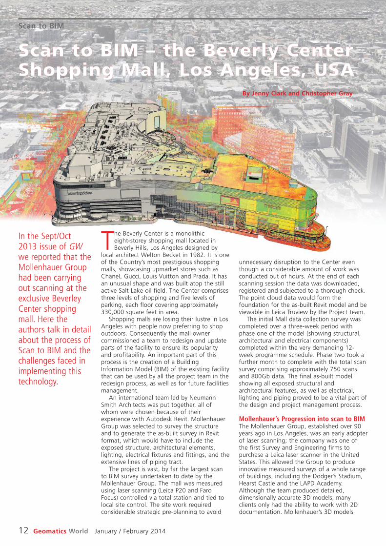
The Beverly Center is a monolithiceight-storey shopping mall located inBeverly Hills, Los Angeles designed by
local architect Welton Becket in 1982. It is oneof the Country’s most prestigious shoppingmalls, showcasing upmarket stores such asChanel, Gucci, Louis Vuitton and Prada. It hasan unusual shape and was built atop the stillactive Salt Lake oil field. The Center comprisesthree levels of shopping and five levels ofparking, each floor covering approximately330,000 square feet in area.
Shopping malls are losing their lustre in LosAngeles with people now preferring to shopoutdoors. Consequently the mall ownercommissioned a team to redesign and updateparts of the facility to ensure its popularityand profitability. An important part of thisprocess is the creation of a BuildingInformation Model (BIM) of the existing facilitythat can be used by all the project team in theredesign process, as well as for future facilitiesmanagement.
An international team led by NeumannSmith Architects was put together, all ofwhom were chosen because of theirexperience with Autodesk Revit. MollenhauerGroup was selected to survey the structureand to generate the as-built survey in Revitformat, which would have to include theexposed structure, architectural elements,lighting, electrical fixtures and fittings, and theextensive lines of piping tract.
The project is vast, by far the largest scanto BIM survey undertaken to date by theMollenhauer Group. The mall was measuredusing laser scanning (Leica P20 and FaroFocus) controlled via total station and tied tolocal site control. The site work requiredconsiderable strategic pre-planning to avoid
In the Sept/ Oct2013 issue of GWwe reported that theMollenhauer Grouphad been carryingout scanning at theexclusive BeverleyCenter shoppingmall. Here theauthors talk in detailabout the process ofScan to BIM and thechallenges faced inimplementing thistechnology.
Scan to BIM – the Beverly CenterShopping Mall, Los Angeles, USA
By Jenny Clark and Christopher Gray

Scan to BIM
January / February 2014 Geomatics World 13
works. BIM is not just a 3D model, but both anew process and a new way of thinking.
Revit and other BIM platforms wereoriginally intended, and have beenpredominantly used for, the design andconstruction of new builds. The need to retainand remodel existing buildings however, is animportant and growing market. To betterunderstand and analyse the structure,condition and form of an existing building thehidden structural components andfoundations, as well as the details of thebuilding fabric need to be known. Althoughsurveyors are limited to providing a measuredsurvey of the visible exposed structure andarchitectural detail only, the geometricallyaccurate ‘BIM ready’ model generatedprovides a fundamental base level of data forother stakeholders to add their specificinformation (the ‘I’ in BIM). When modelledcorrectly (i.e. as Revit elements) the surveymodel is the foundation, providing ageometrically accurate base model for thecomplete project team to design, manage andco-ordinate all stages of the project.
Lessons learnt / critical factorsBIM projects are a collaborative process andgood communication with the client rightfrom the beginning is paramount to manageexpectations and to ensure a successfuloutcome. This in part takes the form of a clearand unambiguous specification defining thelevel of detail required and what will and,possibly more importantly, what will not beincluded.
It is difficult to generate a survey modelbased on specifications put together byorganisations such as the BSI and AIA whichfocus on new construction, for example, PAS1192 and AIA LOD. For example, the Revitelements comprising the Beverly Center as-
tended to be used by clients for visualisationsand animations rather than design andconstruction. The former are still valid uses ofthe data, but the team was keen to explore amore efficient and usable software whichwould permit valuable data interrogation andinteraction.
In 2003 the USA‘s General ServiceAdministration (GSA) rolled out acomprehensive and far reaching nationalmanagement program utilising 3D-4D-BIM toaccurately document all capital facilities usinglaser scanning with the intention ofgenerating a foundation of a BIM for eachbuilding. The concept was forward thinkingand innovative, especially at that early time,embracing the idea of generating anintelligent model that could be shared bymultiple stakeholders throughout the lifecycleof the facilities. At the same time many largeAmerican contractors were moving towardsthe provision of their data in BIM, seeingsignificant savings using a single integratedmanagement system where the whole projectteam uses the same dataset and allowingmore effective scheduling, management andclash detection.
RecognitionArchitects and Engineers began to recognisemore and more the value of BIM to design.Mollenhauer Group, seeing the potential ofproviding surveys in 3D that could beintegrated into BIM as an essential componentof the redesign and management of existingbuildings, decided that this was the criticaltime to commit. The team invested in thedevelopment of as-built surveys in Revit, whichwas rapidly becoming the AEC industrystandard software of choice.
However, the initial uptake of surveys inRevit was slow. Although clients committed toimplementing BIM into their workflow,converting entire workforces to work in 3Dwithin a BIM package has been a learningcurve for all and a long process. Today,however, the majority of requests are for 3Dsurveys in Revit format.
In 2009 Mollenhauer Group opened anoffice in the UK specifically focused onmeasured building surveys, with an emphasison surveys in Revit format with all training anddevelopment based around this. Mollenhauercarries a range of scanners (Faro and Leica)which are used depending on the siteconditions and project specifics. Although thedata can be collected anywhere theprocessing, analysis and modelling is in themost part carried out in the UK office. Theteam comprises surveyors and architecturalspecialists who together have the ability tocreate accurate surveys of the builtenvironment using a combination ofconventional and laser scan survey. Movinginto the realms of “Scan to BIM” hascompletely changed the way Mollenhauer
The project was by far the largest scan to BIM undertaken. Because of the sizeand complexity of the mall considerable work was carried out after hours.
Although clientscommitted toimplementing BIMinto theirworkflow,converting entireworkforces towork in 3D withina BIM package hasbeen a learningcurve for all and along process.
‘‘
’’
Scan to BIM
14 Geomatics World January / February 2014
significant amount of time to be modelled inRevit, which will, of course, add significantcosts. It may well be better (and more costeffective) to represent the ceiling using othersurvey techniques, such as simple rectifiedphotography, that can be linked to the model.It must also be kept in mind that aconsiderable advantage of using laserscanning is that it facilitates the capture ofvast amount of detail, establishing a projectdatabase inventory, which will form a valuableresource that can be referred to in the future.
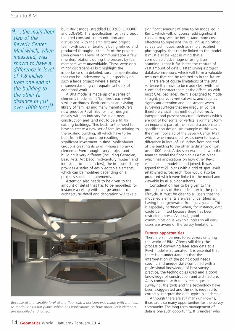
There are of course limitations of the BIMsoftware that have to be made clear with theclient and contract team at the offset. As withmost CAD packages, Revit is designed to modelstraight, perfectly vertical walls, and requiressignificant attention and adjustment whensurveying surfaces that are irregular. So it istherefore critical that methods to correctlyinterpret and present structural elements whichare out of horizontal or vertical alignment forman important part of the initial discussions andspecification design. An example of this wasthe main floor slab of the Beverly Center Mallwhich, when measured, was shown to have adifference in level of 1.8 inches from one endof the building to the other (a distance of justover 1000 feet). A decision was made with theteam to model the floor slab as a flat plane,which has implications on how other Revitelements are modelled and joined. It wasagreed that 2D plans with a grid of spot levelsestablished across each floor would also beproduced which were linked to the model andviewable by all sub-consultants.
Consideration has to be given to thepotential uses of the model later in the projectlifecycle. It must be clear to all users that themodelled elements are clearly identified ashaving been generated from survey data. Thisis especially pertinent when, for instance, datacould be limited because there has beenrestricted access. As usual, goodcommunication is key to success so all end-users are aware of the survey limitations.
Future/ opportunitiesThere are still barriers to surveyors enteringthe world of BIM. Clients still think theprocess of converting laser scan data to aRevit model is automated. It is essential thatthere is an understanding that theinterpretation of the point cloud needsspecific and unique skills combined with aprofessional knowledge of best surveypractice, the technologies used and a goodknowledge of construction and architecture.As is common with many techniques insurveying, the tools and the technology havebeen exaggerated and the skills required tocorrectly interpret the data typically undersold.
Although there are still many unknowns,there are also many opportunities for the surveycommunity. The long term management ofdata is one such opportunity. It is unclear who
built Revit model straddled LOD200, LOD300and LOD350. The specification for this projectrequired constant communication anddiscussions with the architect and projectteam with several iterations being refined andproduced throughout the life of the project.Even given this level of communication a fewmisinterpretations during the process by teammembers were unavoidable. These were onlyminor discrepancies but highlight theimportance of a detailed, succinct specificationthat can be understood by all, especially onsuch a large project where a simplemisunderstanding can equate to hours ofadditional work.
A BIM model is made up of a series ofelements modelled in ‘families’, each withsimilar attributes. Revit contains an existinglibrary of families and many manufacturersnow produce Revit files for their designs,mostly with an industry focus on newconstruction and tend not to be a fit forexisting buildings. This leads to the need tohave to create a new set of families relating tothe existing building, all which have to bebuilt from the ground up resulting in asignificant investment in time. MollenhauerGroup is creating its own in-house library ofelements. Even though every project andbuilding is very different (including Georgian,Beau Arts, Art Deco, mid-century modern andindustrial, to name a few), the in-house libraryprovides a series of easily editable elementswhich can be modified depending on aproject’s specific requirements.
Attention also needs to be given to theamount of detail that has to be modelled; forinstance a ceiling with a large amount ofarchitectural detail and decoration will take a
Because of the variable level of the floor slab a decision was made with the teamto model it as a flat plane, which has implications on how other Revit elementsare modelled and joined.
. . . the main floorslab of theBeverly CenterMall which, whenmeasured, wasshown to have adifference in levelof 1.8 inchesfrom one end ofthe building tothe other (adistance of justover 1000 feet).
‘‘
’’
Scan to BIM
January / February 2014 Geomatics World 15
meet the needs of all.BIM is not just a new way of modelling, it is
a new way of working. There is a significantrole for Geomatics Surveyors in thisburgeoning market but we need support fromadvisory bodies such as the RICS to ensurethat we all adhere to clear guidelines andspecifications, allowing us to provide acoherent service.
About the AuthorsJenny Clark MRICS, Director of MollenhauerGroup LtdJenny graduated with a Masters in Surveyingfrom UCL in 2000 and has over 10 years’experience of laser scanning and 3D modellingin both the USA and UK. She spearheads thedevelopment of Mollenhauer’s Revit surveysand has worked on an array of scan-to-BIMprojects across many sectors.
Christopher Gray FRICS, Director of BusinessDevelopmentChris is a Fellow of the Royal Institution ofChartered Surveyors and an internationalexpert with over 30 years of experience in themeasurement of complicated buildings both inthe USA and UK. His career includes head ofsurvey procurement at English Heritage, andhead of survey at the Getty ConservationInstitute.
will ultimately be responsible for themanagement, maintenance and updating ofdata. To ensure long term validity of the data itwould be prudent to carry out repeat laser scansurveys after the planned renovations havebeen completed. This data could be thenincorporated into the final model for futuremanagement and maintenance of the project.This of course relies on the capacity of theproject owner to invest, which in part relies onthe geomatics’ community to make a solid casefor this venture.
There are also opportunities for surveyors innew construction. A programme of scanningthroughout the construction process willprovide an accurate and fast record of theactual development at different stages ofconstruction. Although the initial upfront costsare high, the cost savings in the long termhave been proven. This is still a difficultconcept to sell to a client, but some are nowbeginning to recognise the benefits.
ConclusionKey components for success are goodcommunication at the outset and theagreement on a specification that meets theneeds of all stakeholders whilst remainingwithin the project costs. Reviews andassessment throughout the project arecritical to ensure the modelled components
. . . opportunitiesfor surveyors innew construction.A programme ofscanning through -out theconstruction. . .will provide anaccurate and fastrecord of theactualdevelopment atdifferent stagesof construction.
‘‘
’’
Find the breakthrough products you need to work better, faster, safer and smarter at SPAR International.
There’s only one platform-neutral event that showcases all the major hardware and software solutions in the 3D marketplace.
Neptec
❯ Exhibitors – Compare and qualify solutions from the world’s leading hardware manufacturers and software suppliers
❯ Conference – 90 of the best minds in the industry provide fresh insights and solutions
❯ Networking – Connect with and learn from more than 850 professionals across various industries
❯ Dinner Roundtables – Expand your professional network and deepen your knowledge on one of several hot topics
❯ Live Demonstrations – Observe various data capture and processing tools and see and compare results
❯ Technical Workshops – Learn best practices from top vendors
Presented by: Produced by:
April 14-17, 2014Colorado Springs, Coloradowww.SPARPointGroup.com/International
REGISTER BY February 14 for early-bird rates.
*As of press deadline
Exhibitors*
ARPointGro
April 14-17, 2Colorado Springs, Colora
oup.co.SPwww
014adoom/International
eaFind the br, safer afasterr,
❯ Exhibitors e and– Compards leading harom the world’fr
e supplierssoftwar❯ Conference 90 of the b
akthr
dwar
ough prand smartd qualify solutio
e manuf
best min
❯ Conference – 90 of the besh insightovide frindustry pr
❯ Networking – Connect wiossofessionals acrthan 850 pr
❯ Dinner Roundtables –ofessional network and depr
one of several hot topics❯ Live Demonstrations
ocessing toolse and prcaptur❯ orkshopsechnical WTTe
om top vendorspractices fr
s
best mits andith as v– Eep
–s a
–
oduPrroy:
uced by:
WebGIS willmake GIS easier,it will be real-time, alwaysavailable and toeveryone and itwill look more likesocial media.
‘‘
’’
GIS & Web Cartography
16 Geomatics World January / February 2014
any device can be used. GIS is a means ofunderstanding and communicating. The betterthe cartography, the more effective GIS will be.
Esri has a GeoMentor programme, whichadopts schools and takes geography into theclassroom. It should, of course, already bethere, but Esri can bring resources and ideasthat enhance the experience. A vivid exampleillustrates what GeoMentor can do. Theinspiration was will.i.am of Black Eyed Peasfame, who grew up in a deprived part of EastLos Angeles. He invited Dangermond toarrange a visit by Esri’s GeoMentors to hisformer secondary school. GIS was quite a hit.One pupil discovered that in her area pupilspending was $3300 per pupil per annumcompared to $15,000 in nearby Beverley Hills.She vouched to fight this kind of inequality. Aleader of the future, thought Dangermond,observing that ‘understanding precedes action!’
He is a firm believer that we have thepractical technology to help relieve and guidethe world as it grapples with climate change,migration, terrorism and other 21st centuryblights. ‘GIS and mapping are changing howwe think and act by measuring, analysing,deciding, acting and managing problems’.
GIS has traditionally been the preserve of asmall number of geeks working at a fewexpensive workstations. Dangermond seesWebGIS as the vehicle for scaling up to alarger contextual setting. WebGIS will makeGIS easier, it will be real-time, always availableand to everyone and it will look more likesocial media. The transformation is alreadyhappening. Shell used to employ 400 specialistGIS people but now it is rolled out to 10,000users across the company. Esri’s ArcGIS Onlineis already producing 120 million maps per day.
By transforming GIS into Web GIS, almostanything can be integrated – organisations,people – all helping to break down barriers sothat leveraging traditional geocentric mappingenables the location community like Google,Bing, Facebook, etc. Web maps are distinct,integrated data for social media. The webmodel means disparate databases in thecloud. Visual overlays enable mash-ups todrive the emerging world of spatial analytics.
WebGIS can integrate anything throughdynamic linking between an object andassociated mulitimedia, visual overlays of datausing mashups and through spatial analysismodelling from distributed datasets. It willbreak down barriers and work towards acommon operating picture and situationawareness. It will need a new kind ofcartography and will be powered by services.
Cartography has long been a solitarycraft. Ptolemy, who first mapped theknown world in the second century AD,
relied on reports and descriptions fromtravellers. No originals of his maps survive.Instead we have to rely on medieval copiesprovided by Arab sources, which in turn arebelieved to have copied originals of Ptolemy’sworks. A translation of a translation of a . . .That other great cartographer Mercator alsorelied on reports from travellers andsurveyors. It is said that he never travelledmore than a few kilometres from his home inwhat is now Belgium.
One thing that characterises mapping andcontinues to this day is that cartographers relyon what has gone before. At small scale theshape of most areas of the world today is agiven. It is only when you begin to drill downto the local that an accurate survey may berequired to inform the theme of the map.
Today cartographers have so muchinformation at their disposal via the web; butweb mapping has brought with it newchallenges to stretch the cartographicimagination. GIS & Web Cartography was thetheme of an inspiring lecture by JackDangermond, founder of Esri. Mr GIS himself.
Held in the historic and stirring aviationsurroundings of the RAF Club in Piccadilly,Dangermond acknowledged that cartographyis central to GIS. But in very short order GIShas moved from relying on a single underlyingdatabase to that of multiple productsgenerated on demand, with data coming fromsocial media, crowd sourcing and a myriadother sources. The challenge today is tointegrate it and extract actionable information.Web GIS will transform cartography,Dangermond believes.
In the early days of GIS, products tended tobe analytic and maps basic. The objective wasto collect data once and use many times. Atfirst it did not really work, but now the toolsavailable are sophisticated and automatedmap generalisation is possible. Dangermondcited as examples the recently completedSwissTopo 1:25,000 scale mapping, as anentirely automated process. Likewise theDutch cadastre has just completed 1:50,000scale mapping of the whole country, throughgeneralisation of the 1:10,000 scale mapping.GIS has also enabled 3D representation ofmap data and thereby extended thecartographic product range.
GIS enables mapping to connect data frommany sources including the crowd and the webplatform is extending the reach of GIS so that
As part of the BritishCartographicSociety’s 50thanniversarycelebrations, JackDangermond,president of Esri,called in to Londonon his way homefrom the EsriEuropean UserConference toaddress the societyon the next phase inthe development ofGIS. StephenBooth and RichardGroom report.
Web GIS set to transform Cartography– Esri’s Jack Dangermond
Portals, powered by new, light-weight metadata tags, which couldinclude user-ratings, will help usersto search for and organise content.It will allow sharing between‘friends’ in the cloud. It will be ableto select content from variousinterchangeable sources. Forexample base mapping could comefrom the Ordnance Survey, satelliteimagery or StreetView and byswitching between these sourcesthe user will be able to gainmaximum benefit from each.
WebGIS will bring 3D and real-time mapping. We are familiar with3D but real time is a new data typewhich will need cartography tobring impact. Bringing disparatedata together reinforces the needfor standards and for this Esri hasbeen developing solution‘templates’.
No where are these skills andtechnologies emphasised betterthan in emergency response. Backin 2005 the response to hurricaneKatrina was at times poor becausepeople didn’t share information.There was a lack of joined-upgovernment. Since then theNational Information SecurityCenter has been formed in the US.The result could be seen in themuch better response to HurricaneSandy that hit New Jersey, a biggerstorm than Katrina but with far less lethalhuman impact.
Organised through new portals, web GIS isaccessible from any client web-enabled device –phone, laptop, tablet, desktop – enablingsharing through the cloud. But we need a newcartographic standard for this architecture,argues Dangermond. Online base maps arenecessary, directing us to ArcGIS online, whereafter only a year there are now one millionmaps shared in the cloud. Web GIS can alsointegrate real-time information with a move to3D web scenes from video feeds and to 3Drenditions. This is now a multi-device world forcartographers, where already web GIS isintegrating with Microsoft Office. Using Excel,maps can be imported to ‘geo enrich theenterprise’ asserts Dangermond. GIS by stealth!
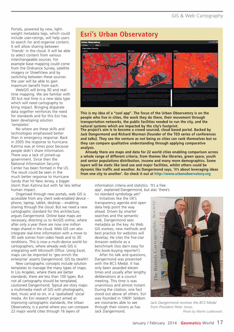
New cartographic concepts include solutiontemplates to manage the many types of maps.In Los Angeles, where there are betterstandards, there are less than 100 types. Butnot all cartography should be templated,cautioned Dangermond. Typical are story maps:a multimedia mesh of GIS with photographs,text, music and so on, in a ‘spatialised’ socialmedia. An Esri research project aimed atimproving cartographic standards, the UrbanObservatory, is a portal where you can compare22 major world cities through 16 layers of
GIS & Web Cartography
January / February 2014 Geomatics World 17
information criteria and statistics. ‘It’s a freeapp’, explained Dangermond, but alas ‘there’sno standard symbology yet!’
Initiatives like the UK’stransparency agenda and opendata help point the wayahead. Driven by smartersearches and the semanticweb, Dangermond seesmetadata as the key. As WebGIS evolves, new methods andbest practice for websites willdevelop; He cites the five-starAmazon website as abenchmark (too darn easy forthis book-buying reporter!).
After his talk and questions,Dangermond was presentedwith the BCS Medal. It hasonly been awarded eleventimes and usually after lengthydeliberations at a councilmeeting. This time is wasunanimous and almost instant.During the citation, one factstood out above all others. Esriwas founded in 1969! Seldomare visionaries able to seethrough their visions as hasJack Dangermond.
This is my idea of a “cool app”. The focus of the Urban Observatory is on thepeople who live in cities, the work they do there, their movement throughtransportation networks, the public facilities needed to run the city, and thenatural systems which are impacted by the city’s footprint.The project’s aim is to become a crowd sourced, cloud based portal. Backed byJack Dangermond and Richard Wurman (founder of the TED series of conferencesand talks). They see the venture as not being so cities can rank themselves but sothey can compare qualitative understanding through applying comparativeanalysis.
Already there are maps and data for 22 world cities enabling comparison acrossa whole range of different criteria, from themes like libraries, green space, youthand senior populations distribution, income and many more demographics. Somelayers will be static like land use and major facilities, whilst others could bedynamic like traffic and weather. As Dangermond says, ‘it’s about leveraging ideasfrom one city to another’. Go check it out at http://www.urbanobservatory.org
Esri’s Urban Observatory
Jack Dangermond receives the BCS Medalfrom President Peter Jones.
Photo by Martin Lubikowski.
18 Geomatics World January / February 2014
prism is always known either via RTK or, if RTKis not available, using navigation grade data, sothat the Tesla can tell the total station to rotatetowards the prism. At present surveyors observecontrol at the start of the instrument set up butthe next release of MAGNET Field will allowsurveyors to add control at any time and willrecompute the position and orientation of theset-up with each new observation.
The delegates went outside to see it all workin practice, whereupon a steady drizzle began.The equipment has a higher IP rating (totalstation: IP65, GNSS: IP67) than the delegates, butwe persevered. The MAGNET Field user interfaceis chunky, which is good news for those of uswho need ever more powerful reading glasses,and is also intuitive. The software cancommunicate with the cloud for transfer of fileseither between teams on a particular site or withthe office and there is a “chat” facility, enablingthe surveyor to communicate with othermembers of the field team, or the office.
MAGNET is the glue that holds this systemtogether but to use network RTK or to storedata to the cloud demands a mobile phonesignal. So what do you do if there is none?The answer is probably to observe some staticGNSS control points and then use base androver RTK for the detail survey.
MAGNET also comes in Enterprise andOffice forms. The office variant now featuresseamless integration with AutoCAD Civil 3D,reflecting the ongoing collaboration betweenTopcon and Autodesk. Unfortunately, in ahalf-day session it was not possible to seemore of the technical functionality ofMAGNET Office.
Keeping an eye on thingsThe Enterprise software is essentially amanagement tool. The survey manager cansee who is where at any time. This mightseem intrusive, but perhaps it should not beseen as such. Certainly, it should concentratethe mind of the surveyor, but if there is aproductively problem, the system brings it tothe attention of the manager as early aspossible, so that he can investigate and putthings right quickly. How successfully he doesthat is more a question of his managementskills than of the software that flagged theproblem. Productivity data from MAGNETshould also be invaluable for estimators.
With Hybrid, Topcon appears to havecaught up with other suppliers, who havebeen marketing similar technology for sometime. Based upon the half-day session, it isworth taking seriously.
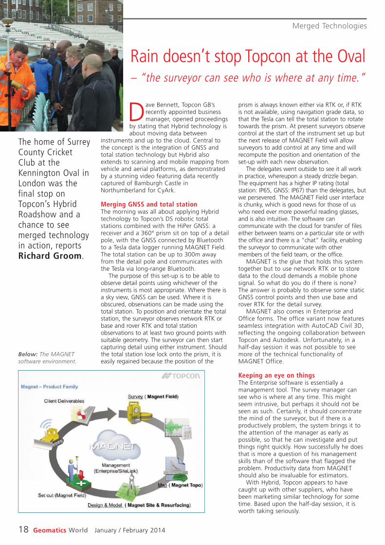
Dave Bennett, Topcon GB’srecently appointed businessmanager, opened proceedings
by stating that Hybrid technology isabout moving data between
instruments and up to the cloud. Central tothe concept is the integration of GNSS andtotal station technology but Hybrid alsoextends to scanning and mobile mapping fromvehicle and aerial platforms, as demonstratedby a stunning video featuring data recentlycaptured of Bamburgh Castle inNorthumberland for CyArk.
Merging GNSS and total stationThe morning was all about applying Hybridtechnology to Topcon’s DS robotic totalstations combined with the HiPer GNSS: areceiver and a 360° prism sit on top of a detailpole, with the GNSS connected by Bluetoothto a Tesla data logger running MAGNET Field.The total station can be up to 300m awayfrom the detail pole and communicates withthe Tesla via long-range Bluetooth.
The purpose of this set-up is to be able toobserve detail points using whichever of theinstruments is most appropriate. Where there isa sky view, GNSS can be used. Where it isobscured, observations can be made using thetotal station. To position and orientate the totalstation, the surveyor observes network RTK orbase and rover RTK and total stationobservations to at least two ground points withsuitable geometry. The surveyor can then startcapturing detail using either instrument. Shouldthe total station lose lock onto the prism, it iseasily regained because the position of the
The home of SurreyCounty CricketClub at theKennington Oval inLondon was thefinal stop onTopcon’s HybridRoadshow and achance to seemerged technologyin action, reportsRichard Groom.
Rain doesn’t stop Topcon at the Oval– “the surveyor can see who is where at any time.”
Below: The MAGNETsoftware environment.
Merged Technologies

SlopeTopo Survey DTM CalculationsStake Points Real-Time Roads
Topcon Great Britain Ltd
1 Minerva Court · Minerva Avenue · CH1 4QL · Chester Phone: +44 1244 669 999 · Fax: +44 1244 669 998 www.topcon-positioning.eu

Hyperspectral Imaging
20 Geomatics World January / February 2014
applications programming interface andsource code for Mathlab and Pythonapplications and there are filters enablingdata to be output to envi, xls and text files.Operation of the helicopter is throughseparate controls.
Agricultural RevolutionIt is possible to use photogrammetrictechniques to produce 3D hyperspectralmodels from cube data and thence tocalculate plant biomass, which is an area ofactive research for a number of Cubert’scustomers. Precision agriculture is the areathat holds most potential for this technologyand the company sees UAVs as central todevelopment. It enables capture of spectralinformation over large areas, which giveschemical information about the plants, cropsand the soil.
By comparison with aircraft and spacecraftplatforms, the combination of high-resolutioncamera and UAV gives scientists a cheap andespecially flexible tool for acquiringhyperspectral data. The data can be used forresearch projects such as phenotyping, thestudy of plants, crops and their environmentthroughout the growing cycle. Cubert foreseesthat in a few years this will lead to farmersbeing able to design crops.
Crop designFor crop design it will be necessary to monitorfrequently, different test breeds of a crop byanalysing many test plots and a large numberof plant properties, such as chlorophyll, lignincontent, growth, water and so on.
In a few years, farmers will be able to ordera detailed field analysis, which will giveinformation about soil quality, fertiliserstrategies, plant health, plant disease,biomass, yields, irrigation, etc. This analysiswill be performed by a specialised serviceprovider and will be cost effective for largeagriculture field sizes as well as higher valuecrops, such as vines and tree nurseries, oversmaller areas. First trials are expected to takeplace next year.
For this technology to become
Hyperspectral and multispectral imagingis usually associated with satellite oraircraft imaging platforms, but
German company Cubert has developed asensor that, at 470g, is so light that it canbe carried by a UAV. The combined systemuses an Optocoptor platform and is calledFirefly.
Cubert’s UD-185 sensor uses full frameimaging technology, which captures eachframe in a millisecond and avoids thecomplications introduced when usingscanning technologies for digital imagery.The data can be transferred to the groundstation during the flight, making it possibleto start analysis before leaving the site. It isalso possible to view the data ashyperspectral video, in real time.
Each frame is 1000 pixels square and isable to record spectral properties for blocks of20 × 20 pixels at a spectral resolution of 4 nmin the wavelength range 450 – 950 nm, using125 channels. The result is what is known as ahyperspectral ‘cube’.
CubeWare has the answersThe camera is controlled using Cubert’s CubeWare software. This enables the operator tomake all the necessary camera settings andcalibrations, control the camera and carry outbasic data analysis. It also includes an
A German companyhas developed alightweighthyperspectralsensor suitable formounting on a UAVwith applications inagriculture, reportsRichard Groom.
Hyperspectral imaging foragriculture ready for take-off– lightweight package is mountedononboard octocopter
Left: The UHD 185records one imageper second until thewhole area wascaptured. Theoctocopter flies inan altitude of 30 –100 m with a speedof 5 -20 km/h.
The Fireflyoctocopter with ahyperspectral cameracould one day enablefarmers to designtheir own crops.

Hyperspectral Imaging
January / February 2014 Geomatics World 21
have to change further to meet thesechallenges. Cubert believes that the currentscheme of UAV regulation is holdingagricultural development back: it should berealistic for the actual risks involved.
In summary, agricultural fields will becomeour new oil fields, so using the availableagricultural areas to the maximum isabsolutely vital. Cubert believes that they havethe right sensing technology for precisionfarming when it is needed.
High-tech start-upCubert GmbH is a high-tech start-up companywhich was founded in 2011 as an offshootfrom the University of Ulm. Their work on thehyprespectral full-frame imager was done in incollaboration with Prof. Bareth and hisworkgroup from the University Cologne.Spectral imaging is a highly interdisciplinaryfield so the founders of the company camefrom very different fields. Rainer Graser hasdeveloped the core technology since 2005. DrRené Michels joined the project in 2010 afterfinishing his PhD studies on scatteringinfluences in spectroscopy and Dr András Jungthen joined the team as an expert in remotesensing applications.
• For more information, visit:www.cubert-gmbh.de
commonplace in the agricultural community,Cubert believes that three points have to beaddressed:
1. The UAV technology has to becomeautonomous; ideally a self-workingdevice is needed, which samples datawithout user interaction.
2. Both, the UAV and the hyperspectraltechnology have to become moreaffordable.
3. Regulation of UAV operation foragricultural use has to be relaxed andpermitted.
The company sees great advances in UAVtechnologies and automation. It is currentlybeing used by pioneers and the cost of thetechnology will reduce as there is greater take-up and more systems are deployed.Agriculture is a vital field and feeding of thenext billion people on earth is one of theworld’s greatest challenges. It is not just aquestion of more mouths to feed, but alsothere will be competition, due to depletion ofoil resources, between growing crops foragriculture and for biofuel. As a result, foodprices rise.
Agriculture is already changing and will
. . . this will leadto farmers beingable to designcrops.
‘‘’’
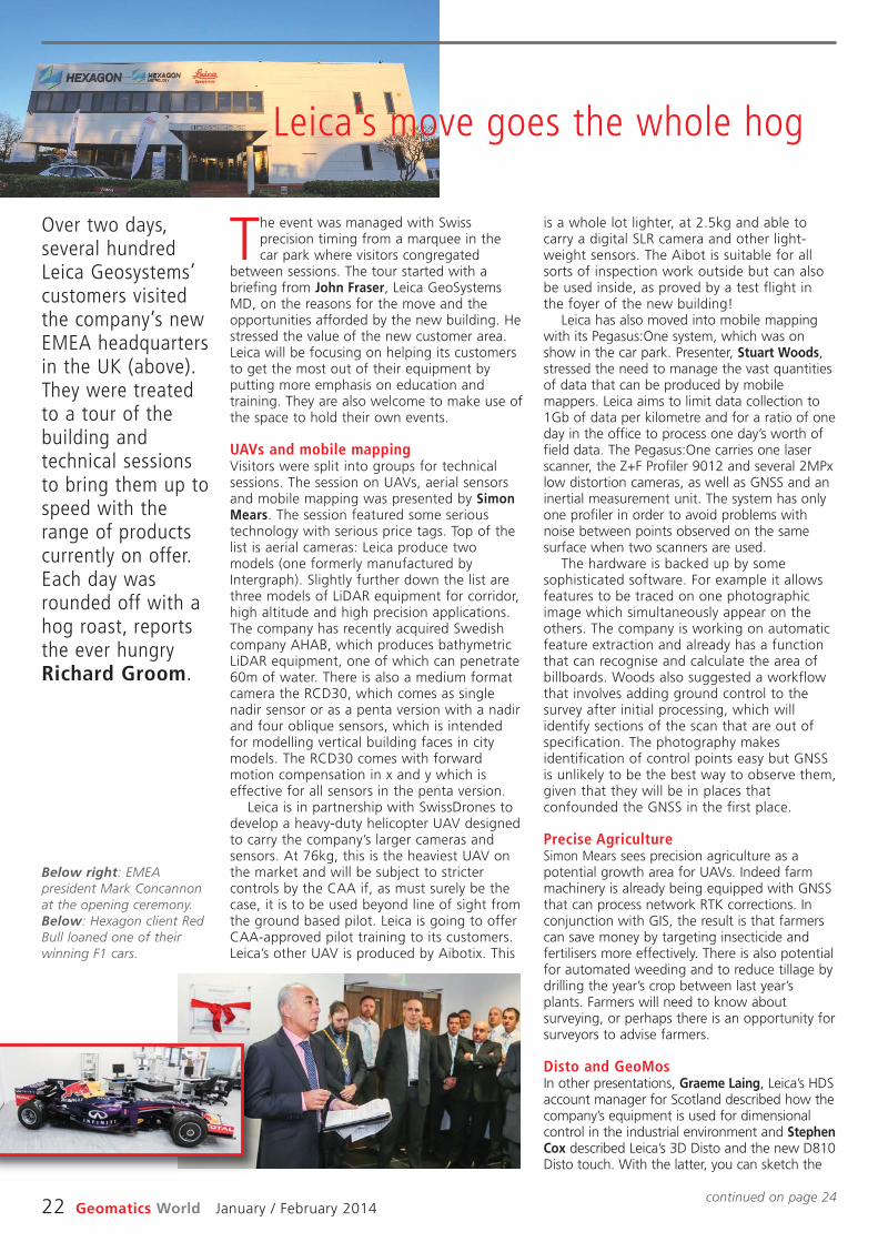
22 Geomatics World January / February 2014
is a whole lot lighter, at 2.5kg and able tocarry a digital SLR camera and other light-weight sensors. The Aibot is suitable for allsorts of inspection work outside but can alsobe used inside, as proved by a test flight inthe foyer of the new building!
Leica has also moved into mobile mappingwith its Pegasus:One system, which was onshow in the car park. Presenter, Stuart Woods,stressed the need to manage the vast quantitiesof data that can be produced by mobilemappers. Leica aims to limit data collection to1Gb of data per kilometre and for a ratio of oneday in the office to process one day’s worth offield data. The Pegasus:One carries one laserscanner, the Z+F Profiler 9012 and several 2MPxlow distortion cameras, as well as GNSS and aninertial measurement unit. The system has onlyone profiler in order to avoid problems withnoise between points observed on the samesurface when two scanners are used.
The hardware is backed up by somesophisticated software. For example it allowsfeatures to be traced on one photographicimage which simultaneously appear on theothers. The company is working on automaticfeature extraction and already has a functionthat can recognise and calculate the area ofbillboards. Woods also suggested a workflowthat involves adding ground control to thesurvey after initial processing, which willidentify sections of the scan that are out ofspecification. The photography makesidentification of control points easy but GNSSis unlikely to be the best way to observe them,given that they will be in places thatconfounded the GNSS in the first place.
Precise AgricultureSimon Mears sees precision agriculture as apotential growth area for UAVs. Indeed farmmachinery is already being equipped with GNSSthat can process network RTK corrections. Inconjunction with GIS, the result is that farmerscan save money by targeting insecticide andfertilisers more effectively. There is also potentialfor automated weeding and to reduce tillage bydrilling the year’s crop between last year’splants. Farmers will need to know aboutsurveying, or perhaps there is an opportunity forsurveyors to advise farmers.
Disto and GeoMosIn other presentations, Graeme Laing, Leica’s HDSaccount manager for Scotland described how thecompany’s equipment is used for dimensionalcontrol in the industrial environment and StephenCox described Leica’s 3D Disto and the new D810Disto touch. With the latter, you can sketch the
The event was managed with Swissprecision timing from a marquee in thecar park where visitors congregated
between sessions. The tour started with abriefing from John Fraser, Leica GeoSystemsMD, on the reasons for the move and theopportunities afforded by the new building. Hestressed the value of the new customer area.Leica will be focusing on helping its customersto get the most out of their equipment byputting more emphasis on education andtraining. They are also welcome to make use ofthe space to hold their own events.
UAVs and mobile mappingVisitors were split into groups for technicalsessions. The session on UAVs, aerial sensorsand mobile mapping was presented by SimonMears. The session featured some serioustechnology with serious price tags. Top of thelist is aerial cameras: Leica produce twomodels (one formerly manufactured byIntergraph). Slightly further down the list arethree models of LiDAR equipment for corridor,high altitude and high precision applications.The company has recently acquired Swedishcompany AHAB, which produces bathymetricLiDAR equipment, one of which can penetrate60m of water. There is also a medium formatcamera the RCD30, which comes as singlenadir sensor or as a penta version with a nadirand four oblique sensors, which is intendedfor modelling vertical building faces in citymodels. The RCD30 comes with forwardmotion compensation in x and y which iseffective for all sensors in the penta version.
Leica is in partnership with SwissDrones todevelop a heavy-duty helicopter UAV designedto carry the company’s larger cameras andsensors. At 76kg, this is the heaviest UAV onthe market and will be subject to strictercontrols by the CAA if, as must surely be thecase, it is to be used beyond line of sight fromthe ground based pilot. Leica is going to offerCAA-approved pilot training to its customers.Leica’s other UAV is produced by Aibotix. This
Over two days,several hundredLeica Geosystems’customers visitedthe company’s newEMEA headquartersin the UK (above).They were treatedto a tour of thebuilding andtechnical sessionsto bring them up tospeed with therange of productscurrently on offer.Each day wasrounded off with ahog roast, reportsthe ever hungryRichard Groom.
Leica’s move goes the whole hog
Below right: EMEApresident Mark Concannonat the opening ceremony.Below: Hexagon client RedBull loaned one of theirwinning F1 cars.
continued on page 24

New HQ
24 Geomatics World January / February 2014
Meanwhile, we shall be reporting more on laserscanning from Leica’s annual user conference,held this year on 4th December at MiltonKeynes. On the monitoring side the new versionof GeoMoS has the capability of modellingdeformation of surfaces by defining the surfacesusing ‘patches’ and then computing movementsnormal to each patch: another problem solved.
room (or object) to be surveyed and then adddimensions to the sketch to watch the surveybuild before you: surely a ‘game-changer’.
In a session on laser scanning anddeformation monitoring Paul Burrows andJames Whitworth covered the options available.It has been fascinating to watch laser scanningmove from a niche to universal technology.
On Tuesday 12 November LeicaGeosystems formally opened its newheadquarters in Tongwell, Milton
Keynes. The ceremony was performed byBrian White, Mayor of Milton Keynes withAlan Peasland of Red Bull Technology. Thenew facility expands by more than 50% theavailable office, warehouse, service space andincludes a striking new conference andseminar suite. The move brings togetherLeica’s EMEA team – covering over 150countries – led by Mark Concannon plus theUK operation under John Fraser and HexagonMetrology under David Brown.
Presiding over the event, Mark Concannonreflected on the 49 years that Leica had beentrading in the UK, beginning with WildHeerbrugg in 1964. In the UK Leica currentlyturns over around £40m. ‘We intend to grow thisbusiness to £50m over the next few years’ saidConcannon. Talking to him afterwards he seesthis growth across all segments of the company’sbusiness but especially civil engineering, machinecontrol, agriculture, mining and GIS. Thecompany is also keen to expand its trainingoperation and has added considerably to itsfacilities to do this. More anon.
Smart city with podsMilton Keynes is a city of 260,000 and one of asmall number advising the government onbecoming “Smart Cities”, explained MayorBrian White. ‘We are bigger than Southamptonand in a few years we shall equal Bristol’. Thecity is a nexus for high technology partnershipsand recently announced a £1.5m plan fordriverless pod cars between the rail station andcity centre. ‘The skills needed by your companyare what we’re trying to encourage in the city’,he said, adding that an engineering degree fromthe city’s technology college is now available.This is good news for Leica which foreseesfurther local recruitment.
One of Hexagon’s key customers is Red BullRacing. The F1 championship winners for thelast four years rely on metrology products andservices provided by Hexagon to maintainquality in the complex engineering of their cars.
Alan Peasland, head of technology partnerships,admitted he was an engineer who rather likedchampagne – and there’s been plenty of that forRed Bull in recent years. He reflected on aneleven-year partnership with Hexagon, which heendorsed as ‘best in class’.
More test and maintenance facilitiesThe new facility is impressive for bothcompanies. Mark Concannon and David Brown,director and general manager of HexagonMetrology, took us on a brief tour. ForGeosystems, the repair and service section hasdoubled capacity with 14 benches equippedwith the latest testing rigs and calibrationinstruments. For Hexagon, which needsconsiderable space for its test and inspectionequipment, the new facility provides muchmore space – it is even possible to get an F1 carin. Their testing and measurement kit isimpressive and measures at the micron level:robot arms with tips that can be comfortablydirected by hand around an object to record itsdimensions; large rigs that stride above weightygranite beds (think fancy kitchen worktops buthalf a metre thick!); test chambers. All a far cryfrom engineers in overalls with handheldmicrometers and callipers.
The building, previously the European hq of aJapanese printer manufacturer, is perhaps not asstriking as that previously occupied in theKnowlhill area of Milton Keynes, which wonawards when it was opened in 1989 by MP andcabinet minister Cecil Parkinson (seen asMargaret Thatcher’s successor until he disgracedhimself with his secretary). Nevertheless, thenew building obviously offers the room for Leicaand Hexagon to expand. Perhaps the mostimpressive aspect is the purpose designedconference suite with seating for a 120, whichcan be divided into two separate units, eachnamed after the engineering Stephensons,father and son: George and Robert. Concannonis especially proud of this facility and said that itwas not just for the company: he wanted theindustry to use the facility too. Don’t miss anearly opportunity to visit the facility, you will notbe disappointed.
New hq marks growth expectationsBy Stephen Booth
The move bringstogether Leica’sEMEA team –covering over 150countries. . .
‘‘
’’

Leica Nova MS50Make the right decision
Leica Nova MS50 – World`s First MultiStation
You only get a moment to make the right decision. So ultimate performance and absolute reliability are critical. Our new Leica Nova MS50 MultiStation combines total station, imaging and scanning technologies together to create a unique solution that covers the complete workflow process from capturing and visualising to deciding, acting on and delivering. Leica Nova: a whole new dimension in measuring technology
www.leica-geosystems.com/nova
Follow us on Twitter: @LeicageoUK
Leica Geosystems LtdHexagon HouseMichigan Drive, Tongwell, Milton Keynes, MK15 8HTTel: 01908 513 [email protected]
January / February 2014 Geomatics World 25
Geomatics and athletics
starting point for numerous successful start-upsin Germany, Europe, and the rest of the world.’
Team tacticsOther winners in the special category includedJOHAN, an application also aimed at the sportsmarket, which uses GNSS to track team membersduring a game and transmit their position, heartrate and so on, to coaches’ computers. From thisthey can derive much more information, such asmaximum acceleration, total distance travelledetc, which is useful during matches as well as forpost-match analysis.
Amongst the regional winners a French appmonitors physical activity with a predictiveelement.
Another winner was the GNSS PerformanceMonitoring System (GPMS) used by airportsand governments to monitor and record GNSSsignals in support of aviation operations.Recorded data can be used to investigateaccidents, and real-time monitoring allows airtraffic control to detect unavailability throughnatural interference, intentional andunintentional jamming and will alert users.
Ampido was another special category winnerthat has already bagged several other awards. Itsets out to find the next free parking space.The idea is that people with unused parkingspaces can advertise them and connect withthose looking for spaces. On-line payment ismade when the deal has been done.
The winner from Spain was ‘BIMOn!’. Thisapplication uses augmented reality to providethe user with a dynamic view of a buildingdesign whilst on the site. The app developerssay that BimOn! will help to improve theconstruction management process by facilitatingdecision making and enabling users to detectproblems at an early stage, which ultimatelyleads to significant savings of time and financialresources. The app uses IFC BIM data.
The UK regional prize went to ManagePlacesand its app that helps managers to managedispersed teams by taking the position of eachteam member from his / her smartphone.
ESNC 2013 gave participants from all aroundthe world the chance to vie for any one of 25regional prizes. In addition, topic-specific specialprizes were sponsored by the followingpartners: the European GNSS Agency (GSA), theEuropean Space Agency (ESA), the GermanAerospace Center (DLR), and - for the first time- the European Patent Office (EPO) and MetaioGmbH. Students and research assistants werealso encouraged to submit their ideas to theESNC University Challenge.
For more visit www.galileo-masters.eu.
Online analysis of athletes’ tactical,technical, and physical capability is playingan increasingly important role in modern
sports training. The underlying idea - known asthe Hawthorne effect – is simple: if you canmeasure your performance, you can also improveit. Following this principle, two research assistantsfrom Technische Universität München (Germany)founded the company Kinexon GmbH at the ESABusiness Incubation Centre, Bavaria anddeveloped a cloud-based solution for analysingand visualising training data on mobile devices.
The solution kits athletes out with a small,portable location sensor and feeds theresulting data into the cloud by means of astationary base antenna. This enables users totrack and analyse performance parametersand tactical movements down to thecentimetre - all in real time. But it was thesolution’s user-friendliness during training andrelatively low cost (compared to the camera-based systems commonly seen today) thatwon over the international jury of experts inthe European Satellite Navigation Competition(ESNC). So far, the high price of such systemshas limited their use to professional sport;Kinexon’s system will now give amateur clubsthe chance to benefit from adding onlineanalysis to their training activities, as well.
Dr Gerd Gruppe, member of the ExecutiveBoard, German Aerospace Center (DLR),conferred the EUR 20,000 grand prize onKinexon GmbH founders Dr Oliver Trincheraand Dr Alexander Hüttenbrink. ‘DLR sets greatstore in technology transfer,’ explains DrGruppe, adding, ‘innovations form the basis ofeconomic success and hold considerablepotential for society. The ESNC has developedinto a driving force behind the innovative useof satellite navigation technologies and a
With a €1 millionprize pot, the 10thEuropean SatelliteNavigationCompetition (ESNC)awards attractedmany interestingapplications forsatellite navigationtechnologyincluding a mobileapp that providesonline traininganalysis for athletes.
App tracks athletesperformance in real time
Left: Drs OliverTrinchera and DrAlexanderHüttenbrink withtheir prizecertificate andcheque.

26 Geomatics World January / February 2014
structure where there are no vertical walls andno horizontal floors. Whilst this is of noconsequence for point cloud data collection, itis a problem for the modelling process to turnthe point cloud into geometrical surfaces.Modelling is a time-consuming business andfor the RICS building it took six weeks.
Autodesk Revit is rapidly emerging as thesoftware that will be used to create BIM 3Dmodels. But Revit likes right angles and throwsup interesting questions about how to representan uneven, imperfect real world. As King says, itis possible to model non-vertical and unevensurfaces but the process takes longer andtherefore costs more. The sensible solution iscompromise, but the client and contractor mustbe clear on what exactly is going to be done,and for this purpose, close interaction with theclient and a sound specification are essential.The purpose of the model is to simplify reality,but that begs the question – how simple. Tohelp reveal the effect of generalisation, SevernPartnership can reveal the ‘errors’ in the modelby colouring the point cloud to show how fareach point deviates from the modelled surface.
The talk closed with an introduction toSeeable, an interesting new product offeredby Severn Partnership to help release thepower of laser scanning on to any platformusing games technology.
In questions following the lecture, onemember of the audience asked about the costof BIM. Yes, the speakers said, there is a largerup-front survey cost, but projects alreadycarried out have demonstrated that thesavings can be hundreds of thousands ofpounds – in the construction phase alone.
“Are we now at the point of observing scansanyway?” asked another. “Yes” was theresponse. “Scanning equipment is now astandard survey tool.” It is becoming clear thatthe surveyor’s role in BIM is to produce the 3Dmodel on which others hang the attributes thatturn it into BIM. In other words, the 3D Modelis ready for BIM – BIM ready.
This fascinating talk covered the recentproject to survey the RICS headquartersbuilding using laser scanning. The topic
was introduced by Mark Coombes of theSevern Partnership and largely presented byMark King, the partnership’s scanning guru.The first Mark (Coombes) asked for a show ofhands to see where the audience came from.It was split roughly in thirds betweengeomatics, construction and property. BIM isnow of interest to everyone.
The RICS interest in BIM is educational aswell as practical. The organisation hasrecognised that BIM will be central to thefuture of building and infrastructure and so itsemployees and members have to understandwhat it is about. The scan of 12 Great GeorgeStreet was seen as an excellent way to achievethis as well as putting BIM into practice on itsown building stock. The scanning andmodelling has been completed but thelearning is continuing, with the assistance ofthe Severn Partnership, as the full potential ofthe project is explored.
King went through the scanning procedurefrom the installation of plenty of survey controlpoints around and within the building tocollection of point cloud data. At the request ofthe client, some rooms were scanned in greatdetail – like the library, whilst others werescanned from outside of the door, looking in. Itis worth noting that there are still places wherea handheld Disto EDM and tape are morepractical and economic techniques thanexpensive (and heavy) laser scanners.
Dating from the mid 1800’s and havingundergone many changes over the years, theRICS headquarters building is one of the morecomplicated buildings that one is likely tocome across and King summed it up as a
In November, MarkCoombes andMark King gavethe first in thewinter series ofRICS eveninglectures to apacked lecture hallat Great GeorgeStreet.
Below: getting control inthe Library.Centre: external scan ofbuildingFar right: BIM model ofexterior.
. . . it is a problemfor the modellingprocess to turnthe point cloudinto geometricalsurfaces.
‘‘
’’
Scan2BIM or Scan2Model?
• All images courtesy of TheSevern Partnership.

January / February 2014 Geomatics World 27
Land Administration
minutes rather than days. The landregistration authority should also be self-financing.
Adlington offered a list of lessons learnedfrom the reform of land administration in theeastern bloc. The following can be applied toother projects too:
• projects need active champions at thedecision-making level,
• it is better to have a single agency forcadastral surveying and landregistration,
• support services for valuation and legalservices will develop naturally if privatesector involvement is allowed,
• allow plenty of time for piloting,testing and training before ‘roll-out’,
• encourage sporadic registration fromday one and for systematic registration,do it quickly and worry about errorslater, and
• if you put the results on the web, ‘thecrowd’ will report the errors.
Perhaps not so applicable elsewhere was hisassertion that where IT is concerned it isbetter to develop capacity in-house by usinglocal software solutions rather than to buy infrom expensive international suppliers andconsultants.
There was just time at the end of the talkto mention the Land Governance AssessmentFramework (LGAF). This is a tool for dynamicmonitoring of land administration systems andis based on a scoring system that assesseswhat has been done and helps analyse whatstill needs to be done.
Did the title of Gavin Adlington’s talkreally end in a question-mark? Perhapsnot, because the thrust of his argument
was an emphatic ‘yes, they can’.Adlington is Lead Land Administration
Specialist, Program Team Leader for theEurope and Central Asia (ECA) Region withthe World Bank. He joined the organisation in2005 having started working in the ECAregion a decade earlier, shortly after thecollapse of the communist eastern bloccountries in 1989-91. The political collapse inturn caused the eastern bloc economies tocollapse. Private enterprise came in its wakeand with it the need for a change of mindset.The population were unfamiliar with theconcept of land ownership – a fundamentalhurdle to clear. Furthermore, the value of landwas only considered in terms of theagricultural output it could generate. So a citycentre plot suitable for an urban building, likea hotel, would command a lower value thanan agricultural plot in the countryside.
The World Bank is involved because landmarkets can contribute up to 15% of GDPand they come hand in hand with stability. Butfor land markets to work effectively landtenure has to be secure and there has to bean efficient land transfer mechanism.
Adlington went on to list the attributes ofa successful project, one of which is the needfor a primary focus on the client. Here wasanother hurdle, because he found that therewas no concept of ‘customer service’ in theformer eastern bloc. “We call themapplicants”, was the response when he hadraised the question! His focus was thereforeon quick access to the system and reducedturnaround times and costs. Routineregistration of property should not cost morethan $10 per parcel and be completed in
The MichaelBarrett Award isan impressivesilver medal,which is presentedannually to anoutstandingpractitioner in thefield of landadministration, inreturn for whichthe recipientdelivers a lectureto RICS. This year’srecipient wasGavin Adlington,who works for theWorld Bank.Richard Groomreports.
Great changes can happen quickly?
. . . land marketscan contribute upto 15% of GDPand they comehand in handwith stability.
‘‘
’’

Michael Barrett award winner Gavin Adlington (2nd from left) withJames Kavanagh, RICS Geomatics Chair Chris Preston and RICS HonSecRob Mahoney.
NEWS
28 Geomatics World January / February 2014
THE DARK WINTER NIGHTS areupon us with only the thought ofChristmas and the holiday seasonbringing cheer. Still, we at RICShave been doing our best to liftyour spirits with a very wellattended and well receivedannual Christmas lecture andMichael Barrett award held onThurs 05th December. GavinAdlington – Land Program TeamLeader, Europe and Central AsiaDivision World Bank – gave awonderful lecture on the trials,tribulations and ultimatelysuccessful land reformprogrammes within the formerSoviet Union and Eastern Bloccountries. We are making someof the RICS Geomatics EveningLecture resources available onhttps://communities.rics.org/connect.ti/Wikigeo/groupHome
The Evening lectures continueon Thurs 23rd Jan 2014 – UKgeo forum lecture – RICS lecturehall, 17.30 for 18.00 Title:Weaving a new mapping genre -
http://www.rics.org/uk/training-events/conferences-seminars/weaving-a-new-mapping-genre/london/
The big Geo event for 2014,GeoBusiness May 28-29continues to gather pace andRICS was delighted to welcomeour colleagues in the AGI onboard. The GeoBusiness websiteis live @www.geobusinessshow.comopen for registration and standsare booking up fast. The call forpapers @http://geobusinessshow.com/conference/call-for-papers/continues until late Jan.
As always, I’ll reiterate thefollowing: RICS members shouldmake to update their details onthe main www.rics.org withparticular attention being paid toselecting ‘geomatics’ as yourprimary area of practice. This isvery important for yourprofessional group; geomaticsmembership is expanding but we
want to make sure we have all ofyou under our PG wing.
RICS is continuing with the‘big push’ for ‘Online CPD’recording. It’s very easy to use,free and can be accessed athttp://www.rics.org/uk/about-rics/what-we-do/continuing-professional-development/ CPDis a major pillar of the RICSRegulatory system and itsimportance should not beunderestimated. I wouldencourage all geomaticsmembers to ‘log’ the mandatory20 hours by 1st Jan 2014.Have a wonderful start to 2014.
Best practice guidanceand outputOur specialist panels have beenvery busy of late with theBoundaries guidance note - 3rded 2014 online consultationrecently coming to a close(several hundred downloads) andMeasured surveys of land,buildings and utilities 3rd ed2014 (a complete update of theindustry standard 1:500measured surveys specification)going into online consultation.The Boundaries 3rd ed 2014 willbe launched (in conjunction withthe new 4th ed GN Surveyorsacting as expert witnesses)during a multi-date UK roadshowin early 2014. These events arealready booking up and fulldetails can be sourced @http://www.rics.org/uk/training-events/conferences-seminars/neighbourhood-disputes—expert-witness-seminars/ It is a reallycomprehensive programme andbrings boundary disputeknowledge together with expertwitness expertise; a powerful andnecessary combination.
Measured surveys ofland, buildings andutilities 3rd ed 2014This is probably the mostimportant guidance note to beproduced by RICS for 2014 and itis wonderful to see all of thehard work of the specialistworking group come to fruition. Iwould fully encourage allinterested members to eithercomment online or download acopy for reference. The final postconsultation GN is due for
release in spring 2014 and is onthe agenda for GeoBusiness andthe lecture series.
This important documentrepresents a complete review ofthe 1997 edition and supersedesSurveys of land, buildings andutility services at scales of 1:500and larger, 2nd edition andcontains a number of significantchanges such as:• The user guide and best
practice elements are nowfully incorporated within thetext of the document using“grey boxes”. This shouldallow both clients andsurveyors to directly connect“best practice” to specificsections and/or tasks
• The Project informationsection has been expandedand fully revised
• The primary use of the “surveydetail accuracy bandingtable”, which although it stillreferences “scale accuracy”also takes into considerationclient requirements andtechnology changes
• A renewed emphasis on “Grid& survey control”
• Deliverables are also given aseparate section highlightingthe importance of client-surveyor agreement ondefined deliverables andsurvey outputs
• Another change is theintegration of the featuredetail annexes into the mainspecification documentaccording to application. Thisunderlines the fact thatdecisions on what to includein the measured survey arecritical to the success of theproject and to the agreedmeasured survey specification
• Numerous aspects of thisguidance are international innature; comments areespecially encouraged fromgeomatics surveyors workingoutside of the UK.
The third edition is future proofedto emphasise classical surveyingand measurement best practice andmethodology, and is not connecteddirectly to any emerging technologyalthough the advent of BuildingInformation Modelling (BIM) andspecified measured building surveysis mentioned in section 5. Theadvent of the International Property
RICS Policy Watch: Winter 2013
Guides, standards, lectures,consultations. . . The nightsmay be dark but RICS staffand member consultationteams have been busy,reports Land Group DirectorJames Kavanagh.

NEWS
January / February 2014 Geomatics World 29
Measurement Standards (IPMS)initiative is also highlighted withinsection 5. Members can access thedocument @http://www.rics.org/uk/the-profession/how-you-can-contribute/consultation-listing/standards-consultations/measured-surveys-of-land-buildings-and-utilities/
RICS has also released a newupdated suite of public guides fordistribution at Citizens AdviceBureaus and general download.The Neighbour Dispute suitefeatures geo relevant titles suchas Boundary Disputes, Rights ofLight, Party Walls and CompulsoryPurchase (CPO), the full suite oftitles can be accessed @www.rics.org/consumerguides
RICS, ICES and TSA have longpursued a policy of crossendorsement when it comes toclient guides and guidance. Thispolicy continued in Decemberwith the release of the TSA clientguide on Small UnmannedAircraft Surveys (SUA) – anexcellent document on anemerging and increasinglyimportant survey platform. TheTSA client guide can be sourced@ http://www.tsa-uk.org.uk
RICS BIM managercertification gathersmomentumRICS has developed the firstbuilding information modelling(BIM) Manager Certification inresponse to industry need for auniversal standard on which toassess the skills of constructionprofessionals in using BIM. AsBIM continues to dominateprocesses across the builtenvironment, employers andclients are increasingly strugglingto find industry accepted criteriaon which to base knowledge ofpractitioners’ BIM skills. Severalhundred professionals havealready signed up to the RICScertification scheme and RICSwas delighted to have this newground-breaking qualificationhighlighted in the UK andinternational construction media.Interested RICS members andnon-members (it’s open to allwho can fulfill the applicationcriteria) can find out more @www.rics.org/bimmanager
RICS has also recently launcheda new Infrastructure pathway tochartered membership, althoughprimarily focused on the costestimation and related projectmanagement aspects ofinfrastructure delivery, the newpathway also includedcompetencies on BIM andconstruction. The new pathway wasreleased at an opportune moment,just as the UK governmentreleased its Infrastructure policyagenda. More @http://www.rics.org/uk/knowledge/news-insight/news/rics-launches-infrastructure-pathway/
Just to tie up BIM for 2013, areminder of the RICS BIMConference 2014 London, 12 Feb2014. Book your place online now.
RICS has joined forces withour colleagues in ICES, TSA,Ordnance Survey, Leica andothers to form a Survey4BIMgroup under the auspices of theUK Government BIM taskforcehttp://www.bimtaskgroup.org/
International PropertyMeasurement Standards The IPMS initiative continues togain significant momentum withthe recent launch of a new webresource http://ipmsc.org andmore new entrants to the coalitionand supporters of the concept. Thelatest support came from JonesLang LaSalle (JLL) and underlineswhy common internationalstandards in propertymeasurement for valuation areessential. The coalition expects theonline consultation on the firstincarnation of IPMS (office space)to go ‘live’ in early 2014.
Geomatics is at the heart ofIPMS as we tend to be theexperts doing the spatialmeasurement. With the advent oflaser scanning, 3d modelling andmore accurate measured surveytechniques it is now incumbenton geomatics professionals toprovide our valuation andcommercial property clients withthe spatial information theyrequire. IPMS has the potential tobe quite a business opportunityfor geomatics companies ascommercial property companiesstart to adopt a more rigorousapproach to spatial measurementof office space to aid their cross
border comparisons. Geomatics isfully engaged in the coalition andelements of the “detail accuracybanding table” from theMeasured Surveys of land,buildings and utilities 3rd ed2014 are being used to firm upmeasured survey requirementswithin the IPMS global standards.Watch this space…
EU PolicyIt’s been quite a busy late autumnperiod for Brussels and a couple ofgeo-relevant policy items are worthnoting. The European Commissionhas begun a public consultationabout the implementation of theINSPIRE Directive to assess whetherthe actions currently under way arestill on course. Full details can befound athttp://ec.europa.eu/environment/consultations/inspire_en.htmThose of you looking to work assurveyors across the EU should beinterested in how the “mighty”professional qualifications directivehas been developing of late. Amajor step forward occurred inDec 2013 with the results of thecall for expression of interest inthe introduction of the EuropeanProfessional Card (EPC). On 18October 2013, the Commissionpublished a call for expression ofinterest inviting representativeprofessional organisations andassociations at national and EUlevel to express an interest in theintroduction of the EPC. The 1sttranche of professionshttp://ec.europa.eu/internal_market/qualifications/docs/policy_developments/131206_results-call-for-interest_en.pdf does notinclude surveyors but doesinclude estate agents, mountainguides and engineers. The
Commission has also startedresearching how “regulatedprofessions” work within the EU(Evaluating national regulationson access to professions). RICSdoes seem to be in quite a strongposition due to our self-regulatory model (used as anexample of good practice by theEU within the discussion paper).RICS will be feeding into theconsultation in due course.
RICS partners Class ofYour OwnRICS is partnering with A Class ofYour Own (COYO), to help deliverthe secondary school curriculumbased programme DesignEngineer Construct! to a school inClacton, Essex. This initiative wasset up by former land surveyorAlison Watson and architect DanGibson to help young people andtheir teachers to learn more aboutthe wide range of careersavailable to them in the BuiltEnvironment sector and givehands on experience of workingon projects.
COYO provides practicallearning solutions for secondaryschool students, giving them theopportunity to build a virtual ‘eco’classroom. Professional GroupsDirector James Kavanagh, alongsidefellow employees Joe Martin andMatt Saunders, who are all alsoRICS members, led a day ofsurveying activities at ClactonCoastal Academy, Essex, which saw100 school children undertake a fullday hands-on session to designtheir own eco-classroom.http://www.rics.org/uk/the-profession/how-you-can-contribute/adopt-a-school-for-the-design-engineer-construct-programme/
RICS Geomatics lectures are CPD relevant and count towardsyour CPD/LLL quota as specified within RICS regulations. Alllectures are free and open to all (especially students) unlessotherwise specified. All lectures take place at RICS GreatGeorge Street lecture hall and are timed at 17.30 for 1800unless otherwise stated.
Thursday 23 January 2014Geo Forum annual Lecture
Thursday 27 March 2014Engineering Surveying - tbc
GeomaticsEvening Lectures 2013-14

30 Geomatics World January / February 2014
unparalleled 360-degree views. Beyond thetunnel, the largest transportation bore in theworld, is the seismically retrofitted West span ofthe SFOBB, consisting of two double-deck two-tower suspension bridges with a commoncentral anchorage. Soon to be completed is thespecial aesthetic lighting. Designed by a teamthat lit up the Statue of Liberty, Yankee Stadium,and The White House, thousands of LED lightswill illuminate the span’s 200 cables, giving thebridge a cathedral-like appearance.
Finally, the new westbound 4th bore of theCaldecott Tunnel officially opened to thepublic early Saturday morning, November 16,2013. It’s wider, taller and brighter than theother three tunnels, and features a 10-foot-wide shoulder and walkways. It has modernventilation, air and traffic monitoring systems,safety passages into the 3rd bore, trafficlights, and electronic message boards. Manyof these devices have been required in UStunnels as a consequence of the fiery 1982crash in the 3rd bore that killed 7 people, anevent I well remember.
Mergers & acquisitions—the sequel!In my Sept/Oct 2013 column, I noted thatearthmine, the citywide street-level mappingcompany, had been acquired by Nokia. Nosooner had GW hit the presses than Microsoftannounced it was buying Nokia. It’s hard tokeep ahead of the game when one just relieson a bi-monthly journal, so fast does changehappen. Somehow, though, I don’t think I’llbe reporting anytime soon that, say, Amazonhas swallowed Microsoft!
So, the innovative minnow is swallowed upby the giant sea bass with dwindling s(c)ales,which in turn is devoured by a whale that ishard to turn around. I still regret havingupgraded my desktop PC with Windows XP tothe awful Windows 8, obviously designed bykids in a sand pit with a colouring book fortheir play buddies. Swiping my grubby, greasy
fingers across a 22” monitor was somehowless appealing than using a keyboard frommy lap, not to mention the ridiculousinterface. Although Microsoft never reallyacknowledged the problems, it quietlylistened to its users and eventually came outwith version 8.1.
Meanwhile, I graciously allowed my dearwife control over the desktop, while I happilystuck with my lightweight laptop, and quickand easy-to-use Windows 7. I often wonder iftechie groups at Microsoft or Facebook sit
around in meetings deciding what they can donext to keep their jobs, and tinkering with what
Two tunnels for the price of one? Hardly!Or tunnel vision, perhaps? And, do I havean old bridge to sell you! Well, it’s been a
big and successful construction year forCalifornia’s San Francisco Bay Area, and I’vereported on all three of the projects below inpast issues of GW.
First up, March 25, 2013 marked theopening of two parallel tunnels at Devil’s Slideon Highway 1, bypassing a steep, windingportion of coastal road between the towns ofPacifica and Half Moon Bay, long susceptible torockslide-related closures. The final projectcame in at $439 million. I almost managed todrive it mid October, on my way back fromSanta Cruz, but my poor timing coincided withthe annual Halloween pumpkin weigh-in atHalf Moon Bay, and I had to take a diversion.
Then, over the Labour Day weekend, thenew East Span of the San Francisco-OaklandBay Bridge (SFOBB) opened to traffic. At afinal cost of $6.4 billion, the Guinness Book ofWorld Records notes it as the world’s mostexpensive, the reasons for which will beexplored in a future column. The same day thesingle-level new bridge opened, dismantling ofthe 1936 double-deck iron bridge started.
Already a huge success, impressing even long-time critics, the East Span has becomesomething of a tourist attraction. Bikers andwalkers have been almost queuing up to try outthe bike/pedestrian path, and enjoy the Bayviews and majestic 525-feet high singleanchored suspension tower. Because the newbridge is so close to the old one, on the southside as it enters the tunnel bore through YerbaBuena Island, the bike path will not becompleted until early 2015 when demolitionshould be complete. So, at the moment, bikersand pedestrians have to turn around after twomiles. When finished, they will be able to reachYerba Buena and Treasure Islands, and enjoy
An update on theGolden state’smega projects andburgeoningbusiness economyplus some thoughtson social mediafrom our UScolumnist NickDay.
Below: Looking down fromatop the 525 feet high SAStower on the old and new
bridges. The giant boreroad tunnel on Yerba Buena
Island is in the middistance, with San Francisco
in the background.Coastguard station is
bottom left. Inset showsconstruction underway of
old 1936 bridge.
Californian construction update
Overcurrents
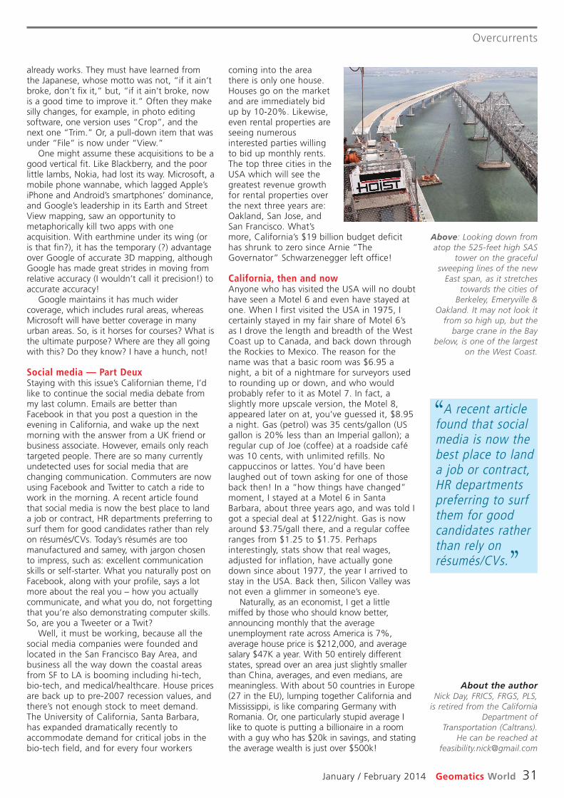
Overcurrents
January / February 2014 Geomatics World 31
coming into the areathere is only one house.Houses go on the marketand are immediately bidup by 10-20%. Likewise,even rental properties areseeing numerousinterested parties willingto bid up monthly rents.The top three cities in theUSA which will see thegreatest revenue growthfor rental properties overthe next three years are:Oakland, San Jose, andSan Francisco. What’smore, California’s $19 billion budget deficithas shrunk to zero since Arnie “TheGovernator” Schwarzenegger left office!
California, then and nowAnyone who has visited the USA will no doubthave seen a Motel 6 and even have stayed atone. When I first visited the USA in 1975, Icertainly stayed in my fair share of Motel 6’sas I drove the length and breadth of the WestCoast up to Canada, and back down throughthe Rockies to Mexico. The reason for thename was that a basic room was $6.95 anight, a bit of a nightmare for surveyors usedto rounding up or down, and who wouldprobably refer to it as Motel 7. In fact, aslightly more upscale version, the Motel 8,appeared later on at, you’ve guessed it, $8.95a night. Gas (petrol) was 35 cents/gallon (USgallon is 20% less than an Imperial gallon); aregular cup of Joe (coffee) at a roadside caféwas 10 cents, with unlimited refills. Nocappuccinos or lattes. You’d have beenlaughed out of town asking for one of thoseback then! In a “how things have changed”moment, I stayed at a Motel 6 in SantaBarbara, about three years ago, and was told Igot a special deal at $122/night. Gas is nowaround $3.75/gall there, and a regular coffeeranges from $1.25 to $1.75. Perhapsinterestingly, stats show that real wages,adjusted for inflation, have actually gonedown since about 1977, the year I arrived tostay in the USA. Back then, Silicon Valley wasnot even a glimmer in someone’s eye.
Naturally, as an economist, I get a littlemiffed by those who should know better,announcing monthly that the averageunemployment rate across America is 7%,average house price is $212,000, and averagesalary $47K a year. With 50 entirely differentstates, spread over an area just slightly smallerthan China, averages, and even medians, aremeaningless. With about 50 countries in Europe(27 in the EU), lumping together California andMississippi, is like comparing Germany withRomania. Or, one particularly stupid average Ilike to quote is putting a billionaire in a roomwith a guy who has $20k in savings, and statingthe average wealth is just over $500k!
already works. They must have learned fromthe Japanese, whose motto was not, “if it ain’tbroke, don’t fix it,” but, “if it ain’t broke, nowis a good time to improve it.” Often they makesilly changes, for example, in photo editingsoftware, one version uses “Crop”, and thenext one “Trim.” Or, a pull-down item that wasunder “File” is now under “View.”
One might assume these acquisitions to be agood vertical fit. Like Blackberry, and the poorlittle lambs, Nokia, had lost its way. Microsoft, amobile phone wannabe, which lagged Apple’siPhone and Android’s smartphones’ dominance,and Google’s leadership in its Earth and StreetView mapping, saw an opportunity tometaphorically kill two apps with oneacquisition. With earthmine under its wing (oris that fin?), it has the temporary (?) advantageover Google of accurate 3D mapping, althoughGoogle has made great strides in moving fromrelative accuracy (I wouldn’t call it precision!) toaccurate accuracy!
Google maintains it has much widercoverage, which includes rural areas, whereasMicrosoft will have better coverage in manyurban areas. So, is it horses for courses? What isthe ultimate purpose? Where are they all goingwith this? Do they know? I have a hunch, not!
Social media — Part DeuxStaying with this issue’s Californian theme, I’dlike to continue the social media debate frommy last column. Emails are better thanFacebook in that you post a question in theevening in California, and wake up the nextmorning with the answer from a UK friend orbusiness associate. However, emails only reachtargeted people. There are so many currentlyundetected uses for social media that arechanging communication. Commuters are nowusing Facebook and Twitter to catch a ride towork in the morning. A recent article foundthat social media is now the best place to landa job or contract, HR departments preferring tosurf them for good candidates rather than relyon résumés/CVs. Today’s résumés are toomanufactured and samey, with jargon chosento impress, such as: excellent communicationskills or self-starter. What you naturally post onFacebook, along with your profile, says a lotmore about the real you – how you actuallycommunicate, and what you do, not forgettingthat you’re also demonstrating computer skills.So, are you a Tweeter or a Twit?
Well, it must be working, because all thesocial media companies were founded andlocated in the San Francisco Bay Area, andbusiness all the way down the coastal areasfrom SF to LA is booming including hi-tech,bio-tech, and medical/healthcare. House pricesare back up to pre-2007 recession values, andthere’s not enough stock to meet demand.The University of California, Santa Barbara,has expanded dramatically recently toaccommodate demand for critical jobs in thebio-tech field, and for every four workers
A recent articlefound that socialmedia is now thebest place to landa job or contract,HR departmentspreferring to surfthem for goodcandidates ratherthan rely onrésumés/CVs.
‘‘
’’
About the authorNick Day, FRICS, FRGS, PLS,
is retired from the CaliforniaDepartment of
Transportation (Caltrans).He can be reached at
Above: Looking down fromatop the 525-feet high SAS
tower on the gracefulsweeping lines of the new
East span, as it stretchestowards the cities of
Berkeley, Emeryville &Oakland. It may not look it
from so high up, but thebarge crane in the Bay
below, is one of the largeston the West Coast.
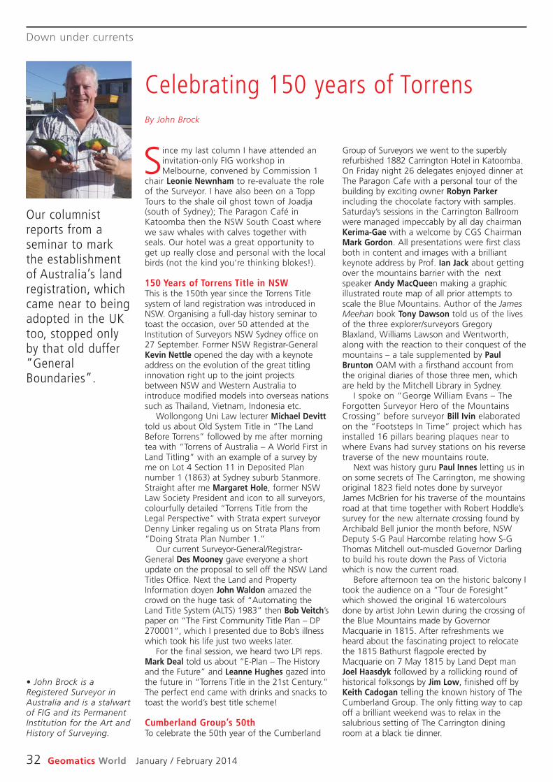
Down under currents
32 Geomatics World January / February 2014
Group of Surveyors we went to the superblyrefurbished 1882 Carrington Hotel in Katoomba.On Friday night 26 delegates enjoyed dinner atThe Paragon Cafe with a personal tour of thebuilding by exciting owner Robyn Parkerincluding the chocolate factory with samples.Saturday’s sessions in the Carrington Ballroomwere managed impeccably by all day chairmanKerima-Gae with a welcome by CGS ChairmanMark Gordon. All presentations were first classboth in content and images with a brilliantkeynote address by Prof. Ian Jack about gettingover the mountains barrier with the nextspeaker Andy MacQueen making a graphicillustrated route map of all prior attempts toscale the Blue Mountains. Author of the JamesMeehan book Tony Dawson told us of the livesof the three explorer/surveyors GregoryBlaxland, Williams Lawson and Wentworth,along with the reaction to their conquest of themountains – a tale supplemented by PaulBrunton OAM with a firsthand account fromthe original diaries of those three men, whichare held by the Mitchell Library in Sydney.
I spoke on “George William Evans – TheForgotten Surveyor Hero of the MountainsCrossing” before surveyor Bill Ivin elaboratedon the “Footsteps In Time” project which hasinstalled 16 pillars bearing plaques near towhere Evans had survey stations on his reversetraverse of the new mountains route.
Next was history guru Paul Innes letting us inon some secrets of The Carrington, me showingoriginal 1823 field notes done by surveyorJames McBrien for his traverse of the mountainsroad at that time together with Robert Hoddle’ssurvey for the new alternate crossing found byArchibald Bell junior the month before, NSWDeputy S-G Paul Harcombe relating how S-GThomas Mitchell out-muscled Governor Darlingto build his route down the Pass of Victoriawhich is now the current road.
Before afternoon tea on the historic balcony Itook the audience on a “Tour de Foresight”which showed the original 16 watercoloursdone by artist John Lewin during the crossing ofthe Blue Mountains made by GovernorMacquarie in 1815. After refreshments weheard about the fascinating project to relocatethe 1815 Bathurst flagpole erected byMacquarie on 7 May 1815 by Land Dept manJoel Haasdyk followed by a rollicking round ofhistorical folksongs by Jim Low, finished off byKeith Cadogan telling the known history of TheCumberland Group. The only fitting way to capoff a brilliant weekend was to relax in thesalubrious setting of The Carrington diningroom at a black tie dinner.
Since my last column I have attended aninvitation-only FIG workshop inMelbourne, convened by Commission 1
chair Leonie Newnham to re-evaluate the roleof the Surveyor. I have also been on a ToppTours to the shale oil ghost town of Joadja(south of Sydney); The Paragon Café inKatoomba then the NSW South Coast wherewe saw whales with calves together withseals. Our hotel was a great opportunity toget up really close and personal with the localbirds (not the kind you’re thinking blokes!).
150 Years of Torrens Title in NSWThis is the 150th year since the Torrens Titlesystem of land registration was introduced inNSW. Organising a full-day history seminar totoast the occasion, over 50 attended at theInstitution of Surveyors NSW Sydney office on27 September. Former NSW Registrar-GeneralKevin Nettle opened the day with a keynoteaddress on the evolution of the great titlinginnovation right up to the joint projectsbetween NSW and Western Australia tointroduce modified models into overseas nationssuch as Thailand, Vietnam, Indonesia etc.
Wollongong Uni Law lecturer Michael Devitttold us about Old System Title in “The LandBefore Torrens” followed by me after morningtea with “Torrens of Australia – A World First inLand Titling” with an example of a survey byme on Lot 4 Section 11 in Deposited Plannumber 1 (1863) at Sydney suburb Stanmore.Straight after me Margaret Hole, former NSWLaw Society President and icon to all surveyors,colourfully detailed “Torrens Title from theLegal Perspective” with Strata expert surveyorDenny Linker regaling us on Strata Plans from“Doing Strata Plan Number 1.”
Our current Surveyor-General/Registrar-General Des Mooney gave everyone a shortupdate on the proposal to sell off the NSW LandTitles Office. Next the Land and PropertyInformation doyen John Waldon amazed thecrowd on the huge task of “Automating theLand Title System (ALTS) 1983” then Bob Veitch’spaper on “The First Community Title Plan – DP270001”, which I presented due to Bob’s illnesswhich took his life just two weeks later.
For the final session, we heard two LPI reps.Mark Deal told us about “E-Plan – The Historyand the Future” and Leanne Hughes gazed intothe future in “Torrens Title in the 21st Century.”The perfect end came with drinks and snacks totoast the world’s best title scheme!
Cumberland Group’s 50th To celebrate the 50th year of the Cumberland
Our columnistreports from aseminar to markthe establishmentof Australia’s landregistration, whichcame near to beingadopted in the UKtoo, stopped onlyby that old duffer“GeneralBoundaries”.
Celebrating 150 years of TorrensBy John Brock
• John Brock is aRegistered Surveyor inAustralia and is a stalwartof FIG and its PermanentInstitution for the Art andHistory of Surveying.

PRODUCTS & SERVICES
January / February 2014 Geomatics World 33
Products mergeWith the release of Leica Cyclone8.1 comes Cyclone BASIC, acomprehensive point cloud utilityfor both field and office thatcombines the former CycloneSCAN and Cyclone VIEWER Proproducts into one application. Inthe field, Cyclone BASIC controlsLeica scanners that can beoperated via laptop. In the office,Cyclone BASIC provides users withnumerous options for viewing andnavigating point clouds and 3Dmodels, as well as working withthem for measurement andmarkup/redlining.
EdgeWise BIM SuiteClearEdge3D has releasedEdgeWise BIM Suite for as-builtBuilding Information Models. Theplatform, which consists ofEdgeWise MEP and EdgeWiseBuilding software, automaticallyextracts piping, conduit, roundducting, walls and windows frompoint cloud data. The software isfully integrated with Revit, creatinga powerful as-built modellingtoolset within the Autodeskenvironment. With EdgeWise, wallscan be exported to Revit plumband square and best fit to thepoint cloud or converted to theirexact as-built condition. Usershave already reported dramaticworkflow savings.
GeoCalc 6.7 SDK Blue Marble Geographics hasreleased GeoCalc 6.7 softwaredevelopment kit (SDK) featuringenhanced speed and memoryhandling. The release of alsofeatures speed and memoryenhancements for performingcoordinate transformations aswell as added support for theNGS-VDatum system allowing fortidal vertical references along theUS coast. The release includesnew support for Vertical Datumreferences EGM 2008, Geoid2012a and Finnish 2000/N60height models.
Next generation Trimble has introduced the nextgeneration of its TrimbleGeoExplorer handheld datacollectors. The Geo 7X includesan integrated laser rangefindermodule, extended GNSScapabilities and improvedhardware performance. Togetherwith robust field and officesoftware, the device can enhanceproductivity in difficult physicalconditions and challenging GNSSenvironments. For times whenoccupying a position is simply notpossible, users can easily captureoffset measurements from theinbuilt rangefinder module. TheGeo 7X also includes technologyto deal with situations when
heavy overhead cover obstructssatellite signals.
New Topcon datacontrollerTopcon has announced the FC-336 data controller, designed forthe construction industry. Inaddition to providing field crewswith access to the company’sMAGNET Enterprise cloudsolution to send and receive datafiles, the controller operates withMAGNET Field, Site and Layoutsoftware. The controller is dustand waterproof (IP68 rating), hasa Windows 6.5 operating systemand built-in Bluetooth and WiFiconnectivity plus a 1GHzprocessor, 5Mpx camera, 512MbRAM, 8Gb of data storage, E-compass and altimeter.
RTX correction serviceTrimble has announced that itsCenterPoint RTX correctionservice will be available across itsentire airborne mapping portfolio.The RTX service is a PPP solutionoffering an accuracy of betterthan 10 cm RMS horizontal afterconvergence, which takes up to30 minutes to gain full accuracy.The service offers speed and lowcost because there is no need toset up base stations and there isno need to wait for delivery ofpublic-domain ephemeris data.
Setting out revolution
Topcon has announced the LN-100, a robotically-operatedinstrument with which thesurveyor can select the point orline to be staked out by clickingthe feature on an electronicdesign drawing on the controller.The LN-100 then immediatelypoints to the exact location. It willalso lock onto a prism and guidethe operator to the design point.
Data assistantExprodat has released DataAssistant, an addition to its
Team-GIS suite of oil and gassoftware to provide the toolsneeded to transfer data betweencommonly used oil and gas dataformats and ArcGIS. Supportedinput formats include; Petrel,KINGDOM, SeisWorks,OpenWorks, Geographix, CPS3,IESX and UKOOA P1/90.
iSTAR sees in the dark!iSTAR has just announced thenew “IR” version of iSTAR thatcan take panoramas in zero lightconditions. The new product isattracting attention from thespecial operations and lawenforcement markets. Thecompany has also launched aniSTAR SDK for all existing Pulsarowners. The SDK allowsintegration with existing thirdparty software applications andallows iSTAR to be controlled orcommunicate directly withsystems such as remotemonitoring or face detection.
BRIEFS
Trimble’s Quantm technologyintegrates geospatial data alongwith engineering, environmental,social and economic factors intoa simultaneous analysis of alter -na tives, delivering alignmentoptions and lower build costs.
Chronos has announced a rangeof GPS interference and jammingdetection and monitoring productsand services for criticalinfrastructure, law enforcementand services dependent on GPSand (in the future) Galileo signals.
A new version of ARES Commanderincludes a full set of features tocreate and modify 2D or 3Ddrawings directly in DWG (anyversion up to DWG 2013). Graebertsees the software as a wake-up callfor Autodesk in the CAD market.
Sabre Land & Sea, of Deeside,Aberdeenshire, has orderedtwelve Faro Focus scanners. Thecompany will offer them forrental and sale along with itsSABRE-SCAN mobile mappingsystem, which comes in twoversions: CAR-POD, a ground/marine vehicle-mounted scanningsystem and SKY-POD, a multi-copter-mounted scanning system.
Trailered at Intergeo in October, Topcon has now announced therelease of its new laser. The GLS-2000 combines high speed, longrange and data accuracy and is operated by a colour touch-screenthat provides for one-touch scanning utilising pre-set parameters.The GLS-2000 has a full-dome 360° scanning capability and canoperate at ultra-high speed so that full scans can be completed inunder three minutes, including digital images. The user can alsoselect between two separate lasers according to the project,providing an option to use a Class 1 eye-safe laser where thesituation demands complete safety for the general public.
Topcon’snew scannerhas 360°capability

GW Classified Recruitment
34 Geomatics World January / February 2014
G W R E C R U I T M E N T
We are currently looking for two graduates to fill permanent roles of Geospatial Technical Support Analysts based at our Liverpool Head Office & Huntingdon Operations Centre. Working in the Geospatial Technical Support Team, the principal duties of the successful candidates will be supporting customers with queries arising from the use of Trimble Survey (GPS/GNSS receivers & robotic total stations) & Mapping products and software solutions.
In addition to providing support, the roles also involves providing on site and classroom based training courses to our customers. The roles give the successful candidates a unique opportunity to learn new geospatial positioning technologies as well as substantial career development through Trimble led training programmes.
Candidates will need a degree in the Geomatics/GIS (or similar) field with relevant industry experience being desirable. Recent graduates in Surveying/GIS/Geomatics are welcome to apply. You will be organised, motivated and confident with excellent client facing and presentation skills. You will also have the ability to work as part of a highly skilled and dedicated team.
Knowledge/experience of GPS is desirable, in particular Trimble Survey and/or GPS Mapping products would be an advantage, however full training will be given.
A full driving license is essential.
ApplicationsPlease email cv to [email protected] to apply.
Geospatial Technical Support Analysts
www.korecgroup.com
LAND & MEASUREDBUILDING SURVEYORSwww.ngmsurveys.co.ukNGM Surveys are an established Chartered Land Surveying practiseproviding a range of Land and Measured Building survey services. Weare currently experiencing an increasing workload in all areas, fromnew and existing clients. Our offices in Guildford and Worcester areboth centrally located in their respective towns in modern officespace. Our work is nationwide however the majority is commutablein London/South East/Midlands.
We are looking to recruit surveyors for both offices.
Knowledge of AutoCAD and experience with Leica instruments ispreferred. Also the candidate must demonstrate flexibility, selfdiscipline, drive & professionalism. We are also using Leica laserscanners for surveys and are looking into BIM and 3D CADmodelling, any experience in these areas would be beneficial. Weare primarily looking for experienced surveyors, but would considerrecent graduates. The successful candidate’s package will reflecttheir experience and knowledge.
Please apply by email, attaching your CV and a coveringletter to [email protected].
Midlands Office:Williamson Court2 Foundary Street
Worcester WR1 2BJ
Southern Office:Norwich House14 North Street
Guildford GU1 4AF
As a result of significant business growth and securedworkload Tower Surveys Ltd is currently recruiting fornew Surveyors throughout its UK operation.
We have the following vacancies:
• Measured Building Surveyor – Nottingham • Utility Surveyor – Nottingham • 3D CAD Specialist (Laser Scanning) – Nottingham • Measured Building Surveyor – Milton Keynes • Utility Surveyor – Milton Keynes • Underground Utility Surveyor – Stoke on Trent
Tower Surveys Ltd. is a Chartered Surveying company and is partof Opus International Consultants, a leading professional servicesconsultancy of over 3,000 people, providing advice and projectmanagement across a wide range of service sectors in the UK,New Zealand, Australia and Canada. The Opus name is synonymouswith innovation, professionalism and a solid track record ofdelivering a timely and quality service.
If you wish to apply for any of these roles please apply atwww.opusinternational.co.uk/careers/.
BoundarySurveyor
Technics Group is offering another exciting opportunity. Our busyBoundary Department requires a suitably qualified Senior Land Surveyorto provide the additional resource to facilitate continued growth and tomaintain the expected high level of service to our clients.
Our ideal candidate will have the following qualities:
• RICS Chartered status, preferably with Geomatics affiliation (or having the background and aptitude to gain such status within a short time frame)
• At least five years relevant experience within a mapping and land surveyingenvironment
• Technical experience in a wide range of equipment and methodologies• An appreciation of past, present and future Land Registration matters and
how the OS, Land Registry, and all other parties interact in the process• A mind set and approach appropriate to the stressed working environment
often encountered in dispute resolution• Experience in producing clear concise reports for both clients and courts• Experience as an expert witness in court proceedings• Other appropriate specialised experience such as aerial photography interpretation
The successful candidate will be based at our main office in Guildford, but will be requiredto travel widely, mainly across the South East. A full clean driving licence is essential.
This is an exciting opportunity for candidates who can demonstrate the desireand ability to be part of our proactive and progressive team and who share ourethos for providing a quality service.
Depending on experience and skills starting salary will be between £32,000 and£38,000.
Please send your CV and cover letter to [email protected].
GW Classified
January / February 2014 Geomatics World 35
S U R V E Y S O F T W A R E
WWW.OHMEX.COM
ECHO SOUNDERTIDE GAUGE
WEATHER SYSTEMS
HYDROGRAPHIC EQUIPMENT
G W C L A S S I F I E DTo reserve your space call +44 (0)1438 352617 All ads go online immediately. Next issue: Mar/Apr, copy date: 14 February
Cubert GmbH p.21
GEO Business 2014 inside frontcover
KOREC p.04
KOREC (Recruitment) p.34
Leica Geosystems p.23
NGM Surveys (Recruitment) p.34
Opti-cal Survey Equipment backcover
SPAR International 2014 p.15
Survey Review p.35
Technics Group (Recruitment) p.34
Topcon Europe p.19
Tower Surveys (Recruitment) p.34
ADVERTISERS’INDEX
Web? Email? Print? PR?It’s the marketing mix that counts
By advertising in our Display, Classified orRecruitment sections, you can benefit from
the extra exposure we give regular advertisersin our printed and online News coverage.
Call +44 (0)1438 352617 to discuss howwe can help you realise your marketing plan.

Available to hire or purchase
To find out more about how the Leica Viva TS12 Total Station can help with your project, get in touch now
Best-in-classSearch-Lock-Measure
Best-in-classRadio-field-Controller
Best-in-classSimplicity in the Field
Leica Viva TS12 Performance Robotic package sets a new standard. Together with the easy-to-use Leica SmartWorx Viva software,robotic surveying has never been so easy and productive.
Head Office – Reading
01189 820 500Gatwick Office
01293 538 730Milton Keynes Office
01908 683 726Huddersfield Office
01484 443 270
Finance options available from £95* per week ex. VAT
Leica Viva TS12 Total Station
Example of standard package.
* Based on 24 monthcontract (otherfinance optionsavailable.) B2b only. Finance subject to status.

GeomaticsWorldyour
Digital Extras forJanuary / February 2014 issue
The CyArk 500 Challenge
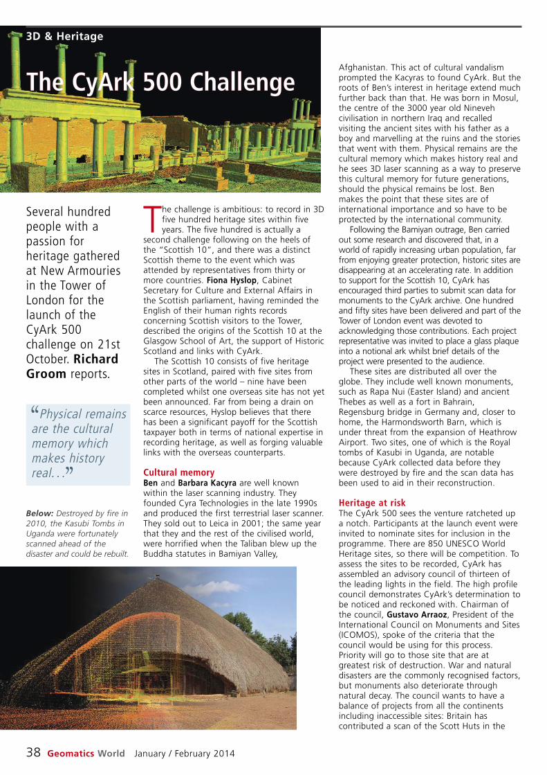
Physical remainsare the culturalmemory whichmakes historyreal. . .
‘‘
’’
3D & Heritage
38 Geomatics World January / February 2014
Afghanistan. This act of cultural vandalismprompted the Kacyras to found CyArk. But theroots of Ben’s interest in heritage extend muchfurther back than that. He was born in Mosul,the centre of the 3000 year old Ninevehcivilisation in northern Iraq and recalledvisiting the ancient sites with his father as aboy and marvelling at the ruins and the storiesthat went with them. Physical remains are thecultural memory which makes history real andhe sees 3D laser scanning as a way to preservethis cultural memory for future generations,should the physical remains be lost. Benmakes the point that these sites are ofinternational importance and so have to beprotected by the international community.
Following the Bamiyan outrage, Ben carriedout some research and discovered that, in aworld of rapidly increasing urban population, farfrom enjoying greater protection, historic sites aredisappearing at an accelerating rate. In additionto support for the Scottish 10, CyArk hasencouraged third parties to submit scan data formonuments to the CyArk archive. One hundredand fifty sites have been delivered and part of theTower of London event was devoted toacknowledging those contributions. Each projectrepresentative was invited to place a glass plaqueinto a notional ark whilst brief details of theproject were presented to the audience.
These sites are distributed all over theglobe. They include well known monuments,such as Rapa Nui (Easter Island) and ancientThebes as well as a fort in Bahrain,Regensburg bridge in Germany and, closer tohome, the Harmondsworth Barn, which isunder threat from the expansion of HeathrowAirport. Two sites, one of which is the Royaltombs of Kasubi in Uganda, are notablebecause CyArk collected data before theywere destroyed by fire and the scan data hasbeen used to aid in their reconstruction.
Heritage at riskThe CyArk 500 sees the venture ratcheted upa notch. Participants at the launch event wereinvited to nominate sites for inclusion in theprogramme. There are 850 UNESCO WorldHeritage sites, so there will be competition. Toassess the sites to be recorded, CyArk hasassembled an advisory council of thirteen ofthe leading lights in the field. The high profilecouncil demonstrates CyArk’s determination tobe noticed and reckoned with. Chairman ofthe council, Gustavo Arraoz, President of theInternational Council on Monuments and Sites(ICOMOS), spoke of the criteria that thecouncil would be using for this process.Priority will go to those site that are atgreatest risk of destruction. War and naturaldisasters are the commonly recognised factors,but monuments also deteriorate throughnatural decay. The council wants to have abalance of projects from all the continentsincluding inaccessible sites: Britain hascontributed a scan of the Scott Huts in the
Several hundredpeople with apassion forheritage gatheredat New Armouriesin the Tower ofLondon for thelaunch of theCyArk 500challenge on 21stOctober. RichardGroom reports.
The CyArk 500 Challenge
Below: Destroyed by fire in2010, the Kasubi Tombs inUganda were fortunatelyscanned ahead of thedisaster and could be rebuilt.
The challenge is ambitious: to record in 3Dfive hundred heritage sites within fiveyears. The five hundred is actually a
second challenge following on the heels ofthe “Scottish 10”, and there was a distinctScottish theme to the event which wasattended by representatives from thirty ormore countries. Fiona Hyslop, CabinetSecretary for Culture and External Affairs inthe Scottish parliament, having reminded theEnglish of their human rights recordsconcerning Scottish visitors to the Tower,described the origins of the Scottish 10 at theGlasgow School of Art, the support of HistoricScotland and links with CyArk.
The Scottish 10 consists of five heritagesites in Scotland, paired with five sites fromother parts of the world – nine have beencompleted whilst one overseas site has not yetbeen announced. Far from being a drain onscarce resources, Hyslop believes that therehas been a significant payoff for the Scottishtaxpayer both in terms of national expertise inrecording heritage, as well as forging valuablelinks with the overseas counterparts.
Cultural memoryBen and Barbara Kacyra are well knownwithin the laser scanning industry. Theyfounded Cyra Technologies in the late 1990sand produced the first terrestrial laser scanner.They sold out to Leica in 2001; the same yearthat they and the rest of the civilised world,were horrified when the Taliban blew up theBuddha statutes in Bamiyan Valley,

3D & Heritage
January / February 2014 Geomatics World 39
archive which is backed up onto tape andstored by the Iron Mountain archive facility. Itis funded by a combination of public andprivate sources, government and researchgrants and financial contributions fromindividual donors, foundations andcorporations.
The CyArk 500 launch event was sponsoredby Iron Mountain, Topcon, Leica, Faro, Riegl, 3DLaser Mapping, Dot Product and Trimble. Allhad stands in a small exhibition area, but DotProduct particularly caught the attention,through its innovative handheld scanner. TheDPI-7 collects data via a PrimeSense Carmine1.08 red, green, blue (photogrammetric) anddepth (infrared) sensor and displays the resultson a Google Nexus 7 tablet in real time usingDot Product’s Phi.3D software. Point cloudaccuracy at 1m range is 2mm (RMS) whichincreases up to the maximum range of 3.5m,where it is 10mm RMS. The user simply movesthe scanner over the object to bescanned to collect data, whichappears on the screen in green inreal time when the point cloud hasbeen processed. It could beparticularly useful for scanningoccluded parts of objects whichwould otherwise involve additionalstatic scanner set ups. The DPI-7 isbased upon Kinect technology, whichwas the subject of a news item in thelast GW. It has been available sinceOctober and costs less than $5,000.
The 500 challenge is not the endof CyArk’s ambitions. It is intendedto build momentum towards thenext 500 and more. As well asasking for financial contributions,CyArk is looking for nominations ofsites for the 500, help with gainingaccess to heritage sites, partners forscanning projects and forcontributions of heritagedocumentation projects to theCyArk archive.
Right: Scanning part of the ancientremains of Merv in Turkmenistan.
Antarctic – the base for the ill-fated SouthPole expedition.
Heritage at warIn the afternoon conference session, ProfessorPeter Stone from Newcastle University spokeon the threat to heritage posed by war. Itshould not happen because the 1954 HagueConvention aimed to protect heritage duringconflict by setting up The Blue Shield – a sortof blue light service for monuments, whichaims to prevent heritage becoming a victim ofconflict. Unfortunately neither the US norBritain have signed up to this Convention. Badnews during the Iraq war, although Iraq hadsigned on the dotted line – but then ignored it.
From the British point of view, theprotection of Iraq’s heritage from US/UKbombing was down to a chance meetingbetween the MoD and a man who knew aman who knew about heritage. Theintermediary said he would have a word withhis acquaintance at the weekend, and that ishow Prof Stone became involved. When askedfor a list of sites that should be protected hetore a sheet from his notebook, took out apen and wrote “Iraq”. No doubt he made hispoint, but he subsequently drew up a moreuseful list and was able to show examples ofsituations where the Iraqis had usedmonuments as shields but fine targeting hadresulted in burnt-out military vehicles with themonument almost unscathed, unlike thelooted National Museum of Iraq.
Stone is now chair of the UK and IrelandBlue Shield Committee, which sits under theinternational committee as part of UNESCO,but has virtually no resources with which to doits work. The committee liaises with the armedforces with a view to building long-termawareness and training before deployment aswell as advising during conflict and reviewingthe consequences when it is all over.
Heritage at riskDr Rohit Jigyasu is UNESCO Chair Professor atRitsumeikan University, Kyoto, Japan. Hisemphasis was on risk. He showed photographsof a church in the Philippines and a monasteryin Bhutan that had recently been destroyed byearthquake. But climate change is alsoincreasing the risk. He pointed to Ayuttaya inThailand, which was flooded in 2011. However,all monuments suffer gradual deteriorationthrough weathering and other natural factors.It is important to keep an eye on them before itis too late. Rapid urbanisation is anotherproblem as sites that were in a rural landscapebecome enveloped within towns and can beput at risk by the development around them, aswell as losing their historic context.
Who funds CyArk?The capture of scan data of monuments is anexpensive business and involves storage ofterrabytes of data. CyArk has a two petabyte
Above, from left to right:Barbara Kacyra with ActingIndian High CommissionerDr. Virander Paul, ScottishCabinet Secretary for Cultureand External Affairs, Ms.Fiona Hyslop and Ms. VivianAllimonos.
. . . asked for alist of sites thatshould beprotected he. . .took out a pen andwrote “Iraq”.
‘‘
’’