geomax general catalogue -...
TRANSCRIPT

GeoMax General Catalogue
Wor
ks w
hen
you
do

GeoMaxAbout Us
At GeoMax we provide a comprehensive portfolio of integrated solutions by developing, manufacturing and distributing quality construction and surveying instruments and software. We address professional as well as occasional users with our easy-to-use, yet highly productive total stations, GPS/GNSS instruments, software, lasers, optical and digital levels and accessories.
Being part of the Hexagon Group, a global technology
group with strong market positions within measurement technologies, grants GeoMax access to state of the art development and production facilities in Europe, America and Asia. Our technology is supported by a broad sales and service network covering all continents and over 100 branches. Through this continually growing distribution and service network, our products are available worldwide delivering outstanding price-performance ratio.
At GeoMax, we concentrate on providing you with the quality and functionality you need in your daily work. Removing the frills enables us to deliver products that “work when you do” – independent of weather, location and task. You get a price-to-performance ratio which you need to succeed in your tough business environment.

GeoMax
GeoMax Digital Level ZDL700 Series
GeoMax Automatic Level ZAL300 SeriesZAL100 Series
GeoMax Laser Rotator ZEL400 Series
ZLT300/200 SeriesZone50 Series
GeoMax Software GGO – GeoMax Geo Office
GeoMax FieldGenius Premium GeoMax Layout Pro
X·PAD Survey & ConstructionX·PAD Android
GeoMax Accessories
GeoMax Quality Management
37
3839
404142
444648495051
52
58
GeoMax Total Stations Zoom80 Series
Zoom35 Pro SeriesZoom30 Pro Series Zoom20 Pro Series
Zipp20 - Open WinCE® SeriesZipp10 Pro Series
GeoMax GNSS Zenith25 Pro Series
Zenith10 & 20 Series
GeoMax Dataloggers PS336 Series
Z710 for X•PAD Android
GeoMax Locators EZiTEX Signal Transmitter
EZiCAT Series
GeoMax Digital Theodolite Zipp02
46
1012141618
202224
283032
3435
36
4
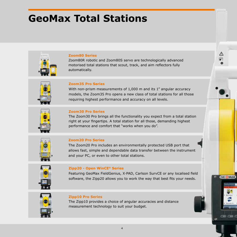
GeoMax Total Stations
Zoom80 SeriesZoom80R robotic and Zoom80S servo are technologically advanced motorised total stations that scout, track, and aim reflectors fully automatically.
Zoom20 Pro SeriesThe Zoom20 Pro includes an environmentally protected USB port that allows fast, simple and dependable data transfer between the instrument and your PC, or even to other total stations.
Zipp20 - Open WinCE® SeriesFeaturing GeoMax FieldGenius, X·PAD, Carlson SurvCE or any localised field software, the Zipp20 allows you to work the way that best fits your needs.
Zipp10 Pro SeriesThe Zipp10 provides a choice of angular accuracies and distance measurement technology to suit your budget.
Zoom30 Pro SeriesThe Zoom30 Pro brings all the functionality you expect from a total station right at your fingertips. A total station for all those, demanding highest performance and comfort that “works when you do”.
Zoom35 Pro SeriesWith non-prism measurements of 1,000 m and its 1” angular accuracy models, the Zoom35 Pro opens a new class of total stations for all those requiring highest performance and accuracy on all levels.

6
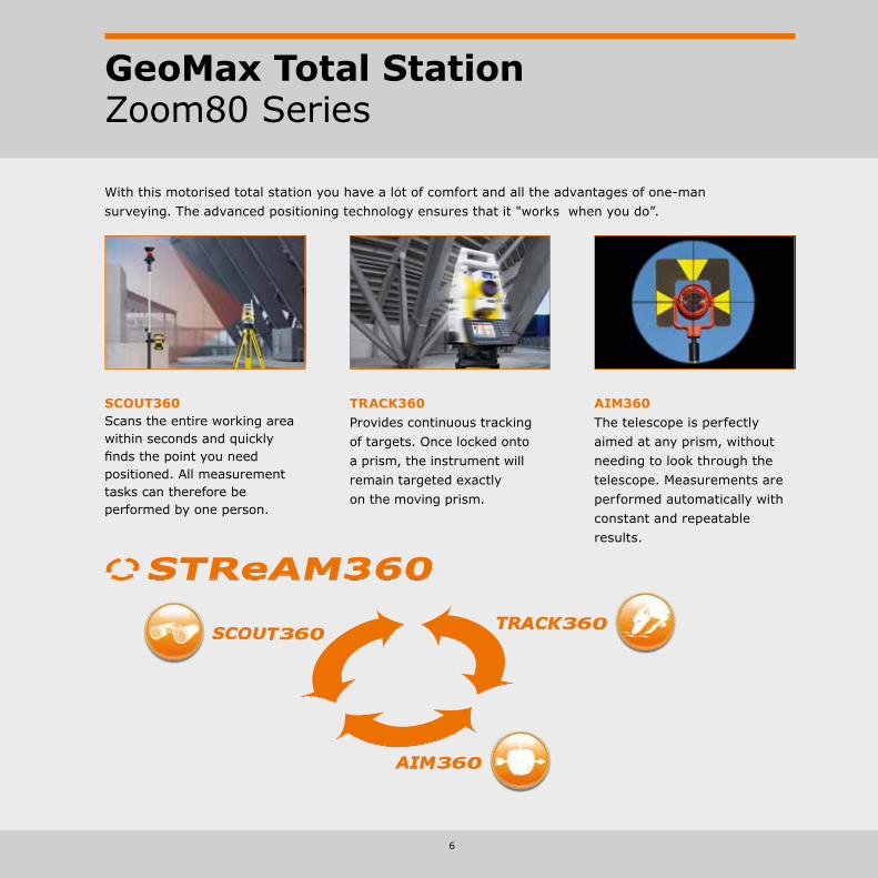
GeoMax Total StationZoom80 Series
TRACK360Provides continuous tracking of targets. Once locked onto a prism, the instrument will remain targeted exactly on the moving prism.
AIM360The telescope is perfectly aimed at any prism, without needing to look through the telescope. Measurements are performed automatically with constant and repeatable results.
SCOUT360Scans the entire working area within seconds and quickly finds the point you need positioned. All measurement tasks can therefore be performed by one person.
With this motorised total station you have a lot of comfort and all the advantages of one-man surveying. The advanced positioning technology ensures that it "works when you do”.
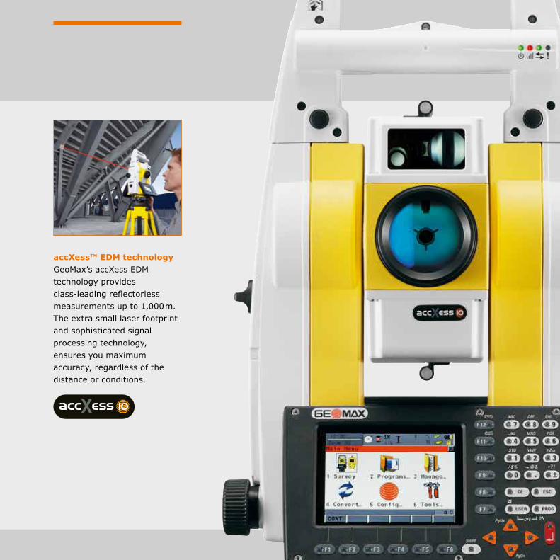
accXess™ EDM technologyGeoMax’s accXess EDM technology provides class-leading reflectorless measurements up to 1,000 m. The extra small laser footprint and sophisticated signal processing technology, ensures you maximum accuracy, regardless of the distance or conditions.

8
GeoMax Total StationZoom80 Series
Technical Data
Accuracy (ISO 17123-3) 5 ”, 2 ”, 1 ” Prism (range, accuracy) 3,500 m, 1 mm + 1.5 ppm Prism, long-range (range, accuracy) 10,000 m, 5 mm + 2 ppm Non-prism (range, accuracy) 1,000 m, 2 mm + 2 ppm* SCOUT360 range 300 m, typical search time 5 – 10 sec TRACK360 range (round / 360° prism) 800 / 600 m AIM360 range (round / 360° prism) 1’000 / 800 m
NavLightThe telescope comes equipped with NavLight, a practical alignment aid for speeding up staking-out work. The flashing red and yellow lights guide the rodman quickly and exactly into the line of sight.
Automated SurveyingAll Zoom80 total stations are equipped with target recognition technology, for automated centring on prisms. The total station needs only to face the prism in order for precise targeting and position measurement to automatically be performed by the instrument. With Automated Surveying, you are much more productive, since each measurement can be completed in only a few seconds.
Robotic surveyingImagine an instrument that does the majority of the work for you, allowing you to survey on your own. There is no need for assistance, it is quick to set up and has many easy-to-use functionalities, simplifying the entire process even more.The GeoMax Zoom80R models provide everything you ever desired in your daily work. Wide angle search technology quickly locates the survey pole and once positioned, it continues to follow the prism as you move.
GeoMax Zoom80S (Servo) 5”, 2”, 1”AIM360, TRACK360
GeoMax Zoom80R (Robotic) 5”, 2”, 1”AIM360, TRACK360, SCOUT360
GeoMax PS3363.5” Full-VGA Quadra-Clear™ technology colour- & touchscreen, Windows® Embedded Handheld 6.5, 29 illuminated keys
* > 500 m: 4 mm + 2 ppm
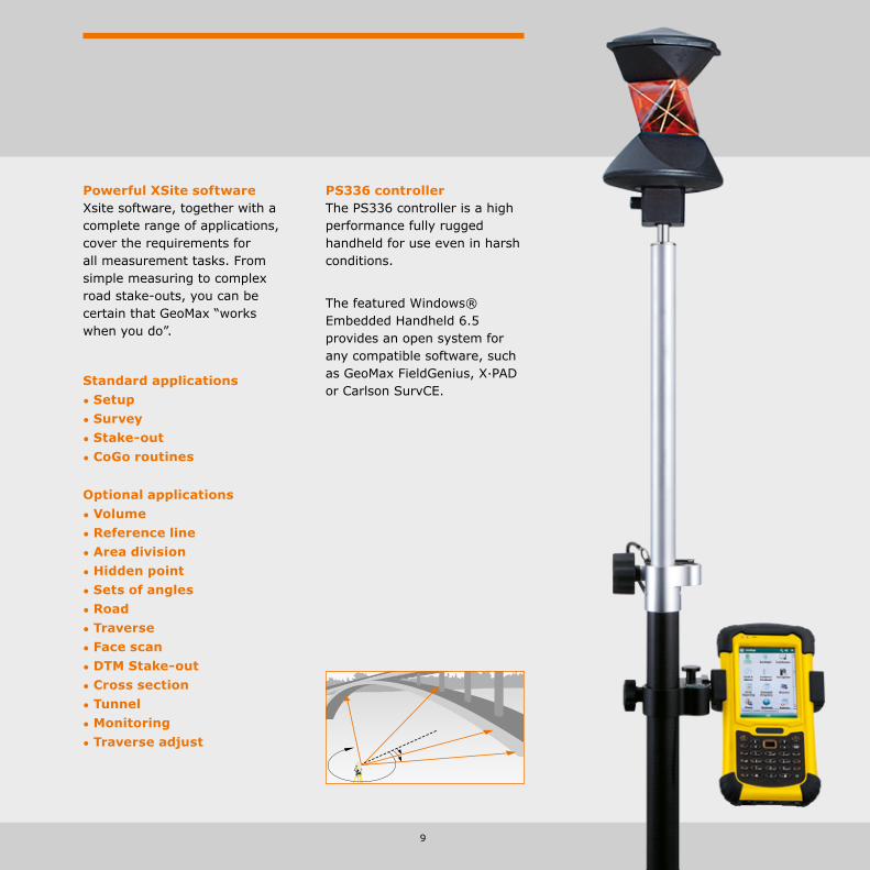
Standard applications• Setup • Survey • Stake-out • CoGo routines
Optional applications• Volume • Reference line • Area division
• Hidden point • Sets of angles • Road • Traverse • Face scan • DTM Stake-out • Cross section • Tunnel • Monitoring • Traverse adjust
Powerful XSite softwareXsite software, together with a complete range of applications, cover the requirements for all measurement tasks. From simple measuring to complex road stake-outs, you can be certain that GeoMax “works when you do”.
PS336 controllerThe PS336 controller is a high performance fully rugged handheld for use even in harsh conditions.
The featured Windows® Embedded Handheld 6.5 provides an open system for any compatible software, such as GeoMax FieldGenius, X·PAD or Carlson SurvCE.
9

With non-prism measurements of 1,000 m and 1” angle accuracy, the new Zoom35 Pro opens a new class of total stations for all those requiring highest performance on every levels.
10
GeoMax Total StationZoom35 Pro Series
Technical Data
Hz, V Standard deviation (ISO 17123-3) 1 ”, 2 ”, 3 ”, 5 ” Compensator system Quadruple-axis compensation Measuring range with prism 10,000 m Accuracy on reflector (Fine/Tracking) 2 mm + 2 ppm / 3 mm + 2 ppm Reflectorless range accXess10 >1,000 m Accuracy reflectorless 2 mm + 2 ppm (>500 m 4 mm + 2 ppm) Communication USB, Bluetooth, USB Host, RS232
Easy connectivityThe GeoMax Zoom35 Pro manual total station includes an environmentally protected USB port, internal Bluetooth® and a cable connection port that allow for fast, simple and dependable data transfer between the instrument and your PC or handheld controller using easy to connect Plug and Play technology.
Colour touch screenThe extra large 3.5” colour touch screen with Q-VGA display provides for brilliant readability even in strong sunlight. Together with an extra large high-resolution display the easy-to-use graphical interface makes regular tasks such as stake-outs easier and more productive than ever before.
Superior accXess10 EDMWith the proven accXess10 technology, the Zoom35 Pro features an intelligent distance measurement engine designed for outstanding speed and highest accuracy even on extremely long ranges. This means a wider operational coverage and significant less time lost with switching set ups.
GeoMax Zoom35 Pro accXess10Distance measurement to reflector and 1,000 m reflectorless measurement

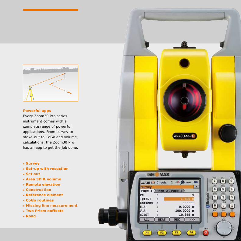
• Survey • Set-up with resection • Set out • Area 3D & volume • Remote elevation • Construction • Reference element • CoGo routines • Missing line measurement • Two Prism Offsets • Road
Powerful appsEvery Zoom35 Pro series instrument comes with a complete range of powerful applications. From survey to stake-outs to CoGo and volume calculations, the Zoom35 Pro has an app to get the job done.

The Zoom30 Pro has all the functionality you expect from a total station right at your fingertips. A total sta-tion for all those, demanding high performance and ease that “works when you do”.
12
GeoMax Total StationZoom30 Pro Series
Technical Data
Hz, V Standard deviation (ISO 17123-3) 2 ”, 3 ”, 5 ”, 7 ” Compensator system Quadruple-axis compensation Measuring range with circular prism 3,500 m Accuracy on reflector (Fine/Tracking) 2 mm + 2 ppm / 3 mm + 2 ppm Reflectorless range accXess 6 / accXess 4 600 / 400 m (white target) Accuracy reflectorless 2 mm + 2 ppm (>500 m 4 mm + 2 ppm) Communication USB, Bluetooth, USB host, RS232
Easy connectivityThe GeoMax Zoom30 Pro manual total station includes an environmentally protected USB port, internal Bluetooth® and a cable connection port that allow for fast, simple and dependable data transfer be-tween the instrument and your PC or handheld controller using easy to connect Plug and Play technology.
Highest functionalityThe Zoom30 Pro combines faster stake-outs with NavLight™ and outstanding non-prism distance measurement over 600 m. With the NavLight™ alignment aid, the rod man can quickly align himself to the line-of-sight without needing instructions.
GeoMax Zoom30 Pro accXess6Distance measurement to reflector and 600 m reflectorless measurement
GeoMax Zoom30 Pro accXess4Distance measurement to reflector and 400 m reflectorless measurement
Colour touch screenThe extra large 3.5” colour touch screen with Q-VGA display provides brilliant readability even in strong sunlight. Together with an extra large high-resolution display, the easy-to-use graphical interface makes regular tasks like stake-outs easier and more productive than ever before.
• Survey • Set-up with resection • Set out • Area 3D & volume • Remote elevation • Construction • Reference element • CoGo routines • Missing line measurement • Two Prism ooffsets • Road
Powerful appsEvery Zoom30 Pro series instrument comes with a complete range of powerful applications. From survey to stake-out to CoGo and volume calculations, the Zoom30 Pro has an app to get the job done.

14
GeoMax Total StationZoom20 Pro Series
Technical Data
Hz, V Standard deviation (ISO 17123-3) 2 ”, 3 ”, 5 ”, 7 ” Compensator system Quadruple-axis compensation Measuring range with circular prism 3,500 m Accuracy on reflector (Fine/Tracking) 2 mm + 2 ppm / 3 mm + 2 ppm Reflectorless range accXess 4 / accXess 2 400 / 250 m (white target) Accuracy reflectorless 2 mm + 2 ppm (>500 m 4 mm + 2 ppm) Communication USB, RS232
Onboard softwareEasily control your data with the flexible and easy-to-use onboard software. Areas and volumes, reference elements, CoGo and more can be accessed using the large graphic display. Import and export in the format you want for total control and flexibility.
Built for all environmentsThe Zoom Pro withstands the toughest environments. With the optional polar certification, the Zoom Pro is individually tested at – 30° C. With our extensive factory tests, you can be sure that GeoMax “works when you do!”.
GeoMax Zoom20 Pro accXess4Distance measurement to reflector and 400 m reflectorless measurement
GeoMax Zoom20 Pro accXess2Distance measurement to reflector and 200 m reflectorless measurement
GeoMax Zoom20 ProDistance measurement on reflector
accXess™ EDM technologyGeoMax’s accXess EDM tech-nology delivers outstanding dependability and class leading accuracy with and without a prism in even the most dif-ficult conditions. Reflectorless accXess EDM technology is available as accXess2 (250 m) and accXess4 (400 m) on the GeoMax Zoom20 Pro series.
The Zoom20 Pro withstands the toughest environments. With the optional polar certification, the Zoom20 Pro is individually tested at -30° C. Our extensive factory tests ensure that GeoMax “works when you do”.

• Survey • Set-up with resection • Set out • Area 3D & volume • Remote elevation • Construction • Reference element • CoGo routines • Missing line measurement • Two prism offsets
Powerful appsEvery Zoom20 Pro series instrument comes with a complete range of powerful applications. From survey to stake-outs to CoGo and volume calculations the Zoom20 Pro has an app to get the job done.
16
GeoMax Total StationZipp20 - Open WinCE® Series
Technical Data
Accuracy (ISO 17123-3) 2”, 5” Range with prism 3,000 m Non-prism range (Zipp10 R Pro) 250 m / 400m (white target)Accuracy with prism 2 mm + 2 ppmNon-prism accuracy 3 mm + 2 ppmMeasuring time (Tracking/Quick/Fine) 0.33 sec / 2.0 sec / 2.4 secReflectorless measuring time 3.0 – 6.0 sec
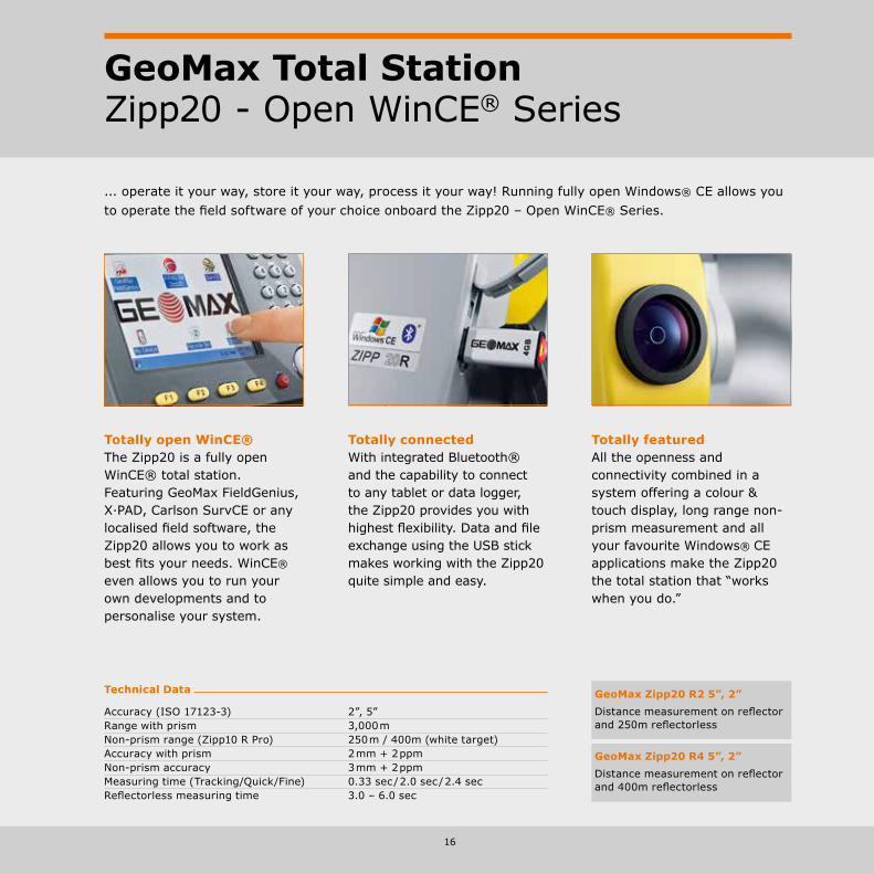
Totally connected With integrated Bluetooth® and the capability to connect to any tablet or data logger, the Zipp20 provides you with highest flexibility. Data and file exchange using the USB stick makes working with the Zipp20 quite simple and easy.
Totally featuredAll the openness and connectivity combined in a system offering a colour & touch display, long range non-prism measurement and all your favourite Windows® CE applications make the Zipp20 the total station that “works when you do.”
Totally open WinCE®The Zipp20 is a fully open WinCE® total station. Featuring GeoMax FieldGenius, X·PAD, Carlson SurvCE or any localised field software, the Zipp20 allows you to work as best fits your needs. WinCE® even allows you to run your own developments and to personalise your system.
GeoMax Zipp20 R2 5”, 2”Distance measurement on reflector and 250m reflectorless
GeoMax Zipp20 R4 5”, 2”Distance measurement on reflector and 400m reflectorless
... operate it your way, store it your way, process it your way! Running fully open Windows® CE allows you to operate the field software of your choice onboard the Zipp20 – Open WinCE® Series.

17
Zipp20 - Open WinCE® SeriesFeaturing GeoMax FieldGenius, GeoMax Layout Pro, X·PAD, Carlson SurvCE or any localised field software, the Zipp20 allows you to work the way that best suits your needs. With integrated Bluetooth® and the capability to connect to any tablet or data logger, the Zipp20 provides you with highest flexibility.
All this combined in a system offering a colour & touch display, long range non-prism measurement and all your favourite Windows® CE applications make the Zipp20 the total station that “works when you do.”

18
GeoMax Total StationZipp10 Pro Series
Technical Data
Accuracy (ISO 17123-3) 2”, 5” Range with prism 3,000 m Non-prism range (Zipp10 R Pro) 250 mAccuracy with prism 2 mm + 2 ppmNon-prism accuracy 3 mm + 2 ppmMeasuring time (tracking/quick/fine) 0.33 sec / 2.0 sec / 2.4 secReflectorless measuring time 3.0 – 6.0 sec
Performance, robustnessProviding a 250 m reflectorless measurement range, a long prism range of 3,000 m, a coaxial visible laserbeam combined with a dust and water resistant sealed durable housing, makes the Zipp10 Pro a top performer in its class.
Multifunctional keyboardWith an ergonomic full numeric keypad for rapid navigation and data entry provides for direct access to apps and fast navigation. The large high-resolution bright display provides brilliant readability even in strong sunlight.
Easy connectivityThe Zipp10 Pro features a simple transfer using a USB stick of all your data and files. Transferring data between different total stations or the office is now easier than ever and liberates you from the need to use any PC.
GeoMax Zipp10 Pro 5”, 2”Distance measurement on reflector
GeoMax Zipp10 R Pro 5”, 2”Distance measurement on reflector 250 m non-prism distance measurement
The Zipp10 Pro is your economic choice when price counts as much as performance. It provides seamless data flow via a USB stick, coaxial reflectorless measurements and a full set of applications. These benefits are proving again best price-to-performance.
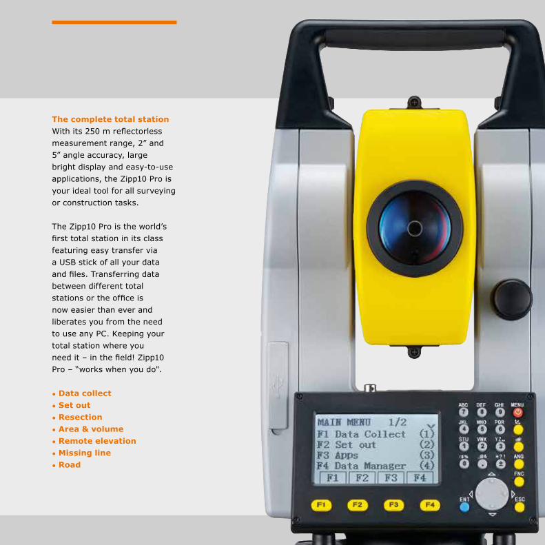
• Data collect • Set out • Resection • Area & volume • Remote elevation • Missing line • Road
The complete total stationWith its 250 m reflectorless measurement range, 2” and 5” angle accuracy, large bright display and easy-to-use applications, the Zipp10 Pro is your ideal tool for all surveying or construction tasks.
The Zipp10 Pro is the world’s first total station in its class featuring easy transfer via a USB stick of all your data and files. Transferring data between different total stations or the office is now easier than ever and liberates you from the need to use any PC. Keeping your total station where you need it – in the field! Zipp10 Pro – “works when you do".
20
GeoMax GNSS
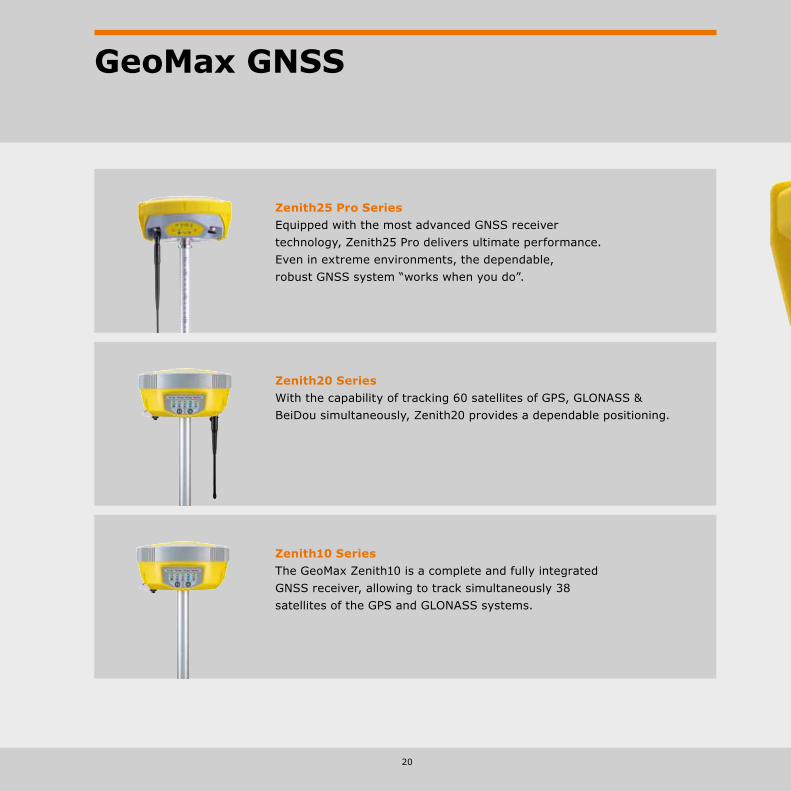
Zenith20 SeriesWith the capability of tracking 60 satellites of GPS, GLONASS & BeiDou simultaneously, Zenith20 provides a dependable positioning.
Zenith10 SeriesThe GeoMax Zenith10 is a complete and fully integrated GNSS receiver, allowing to track simultaneously 38 satellites of the GPS and GLONASS systems.
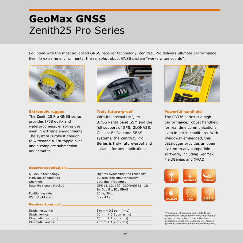
Zenith25 Pro SeriesEquipped with the most advanced GNSS receiver technology, Zenith25 Pro delivers ultimate performance. Even in extreme environments, the dependable, robust GNSS system “works when you do”.

22
GeoMax GNSSZenith25 Pro Series
Equipped with the most advanced GNSS receiver technology, Zenith25 Pro delivers ultimate performance. Even in extreme environments, the reliable, robust GNSS system “works when you do”.
Powerful handheldThe PS336 series is a high performance, robust handheld for real time communications, even in harsh conditions. With Windows® embedded, this datalogger provides an open system to any compatible software, including GeoMax FieldGenius and X·PAD.
Truly future-proofWith its internal UHF, its 3.75G Penta band GSM and the full support of GPS, GLONASS, Galileo, BeiDou and SBAS systems, the Zenith25 Pro Series is truly future-proof and suitable for any application.
Extremely ruggedThe Zenith25 Pro GNSS series provides IP68 dust- and waterproofness, enabling use even in extreme environments. The system is robust enough to withstand a 2 m topple over and a complete submersion under water.
Receiver Specifications
Q-Lock™ technology High fix availability and reliability Max. No. of satellites 60 satellites simultaneously Channels 120, dual frequency Satellite signals tracked GPS L1, L2, L2C; GLONASS L1, L2; BeiDou B1, B2; SBAS Positioning rate 20Hz, 5Hz; Warm/cold start 5 s / 43 s
Receiver Accuracy*
Static horizontal 5 mm ± 0.5 ppm (rms) Static vertical 10 mm ± 0.5 ppm (rms) Kinematic horizontal 10 mm ± 1 ppm (rms) Kinematic vertical 20 mm ± 1 ppm (rms)
* Measurement accuracy and reliability are dependent on various factors including satellite, geometry, obstructions, observation time, ionospheric conditions, multipath, etc. Figures quoted assume normal to favourable conditions.

Q-Lock™ technologyThe Q-Lock™ technology tracks all satellites with the highest available signal strength and performs regular independent checks to ensure that you can work even in challenging environments such as urban canyons or under heavy foliage.
This is all combined in a system robust enough to withstand a 2 m topple over and a complete submersion under water.

24
GeoMax GNSSZenith10 & 20 Series
Complete flexibility The Zenith10 & Zenith20 are completely flexible systems, with all of the communication devices integrated into the antenna. It’s easy to switch between the UHF radio to receive correction data from a local reference station and the GSM modem to receive corrections from a regional network. At times when no corrections are available, raw data can be easily logged for post-processing in the office. The Zenith10 & Zenith20 can also operate as a local reference station, transmitting data either with the internal radio or an external high power transmitter.
Quality GNSS Equipped with state-of-the-art NovAtel satellite receiver technology, the Zenith10 & Zenith20 provide maximum performance. The AdVance® RTK technology, developed by NovAtel, ensures maximum positioning availability under challenging conditions.
Both receivers can track satellite signals of the GPS and GLONASS type. The Zenith20 additionally supports BeiDou and Galileo. By having access to a maximum number of satellites, positions can be determined at any time, ensuring that GeoMax GNSS "works when you do".
Fully integrated GNSSZenith10 & Zenith20 are complete and fully integrated satellite positioning systems. They consist of only two main components, a GNSS antenna and a handheld computer that can be setup on a pole or tripod.
The integrated wireless technology, provides a completely cable-free and light-weight solution that is ready for an entire day’s work.
GeoMax FieldGenius software makes positioning easy and includes many features to satisfy even the most demanding user. Finish tasks faster than ever before with the fully integrated Zenith Series.
The Zenith Series are completely flexible systems, with all of the communication devices integrated into the antenna. A rugged handheld packed with features supports the work in demanding environments and ensures an excellent price-to-performance without compromising quality.
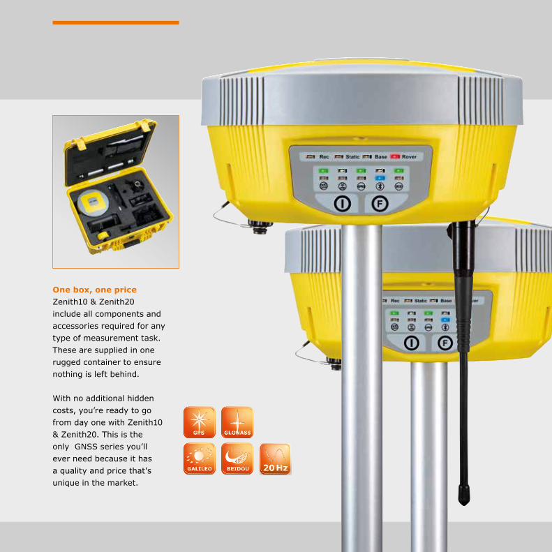
One box, one price Zenith10 & Zenith20 include all components and accessories required for any type of measurement task. These are supplied in one rugged container to ensure nothing is left behind.
With no additional hidden costs, you’re ready to go from day one with Zenith10 & Zenith20. This is the only GNSS series you’ll ever need because it has a quality and price that's unique in the market.
26
GeoMax GNSSZenith10 & 20 Series
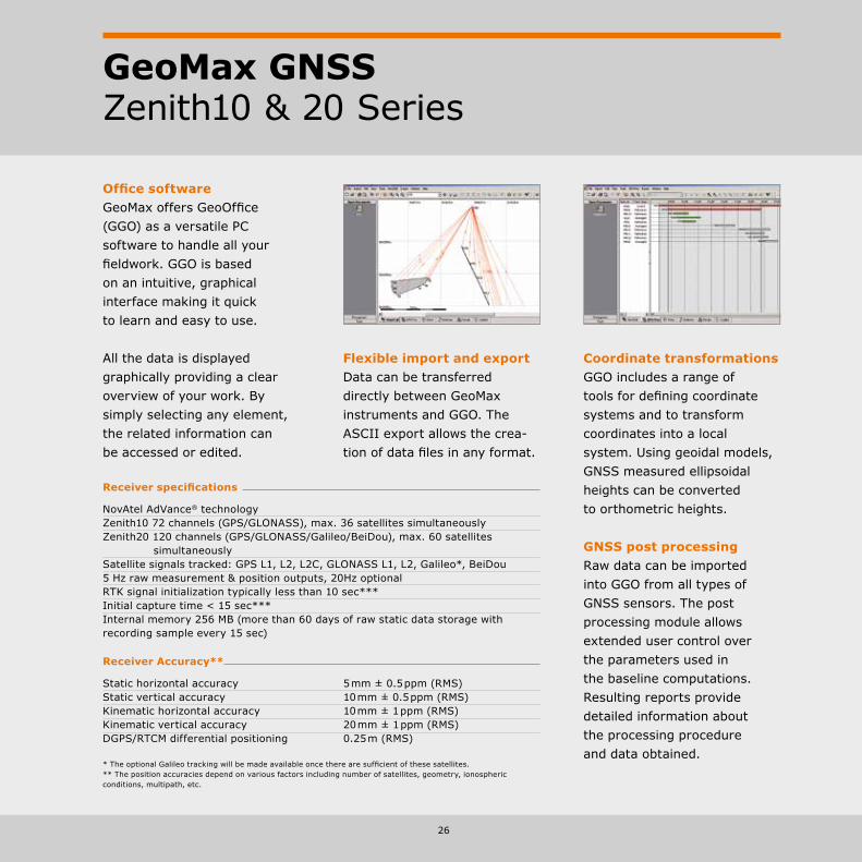
Coordinate transformationsGGO includes a range of tools for defining coordinate systems and to transform coordinates into a local system. Using geoidal models, GNSS measured ellipsoidal heights can be converted to orthometric heights.
Flexible import and exportData can be transferred directly between GeoMax instruments and GGO. The ASCII export allows the crea-tion of data files in any format.
Office software GeoMax offers GeoOffice (GGO) as a versatile PC software to handle all your fieldwork. GGO is based on an intuitive, graphical interface making it quick to learn and easy to use.
All the data is displayed graphically providing a clear overview of your work. By simply selecting any element, the related information can be accessed or edited.
Receiver specifications
NovAtel AdVance® technology Zenith10 72 channels (GPS/GLONASS), max. 36 satellites simultaneously Zenith20 120 channels (GPS/GLONASS/Galileo/BeiDou), max. 60 satellites simultaneouslySatellite signals tracked: GPS L1, L2, L2C, GLONASS L1, L2, Galileo*, BeiDou 5 Hz raw measurement & position outputs, 20Hz optional RTK signal initialization typically less than 10 sec*** Initial capture time < 15 sec*** Internal memory 256 MB (more than 60 days of raw static data storage with recording sample every 15 sec)
Receiver Accuracy**
Static horizontal accuracy 5 mm ± 0.5 ppm (RMS)Static vertical accuracy 10 mm ± 0.5 ppm (RMS)Kinematic horizontal accuracy 10 mm ± 1 ppm (RMS)Kinematic vertical accuracy 20 mm ± 1 ppm (RMS)DGPS/RTCM differential positioning 0.25 m (RMS)
GNSS post processingRaw data can be imported into GGO from all types of GNSS sensors. The post processing module allows extended user control over the parameters used in the baseline computations. Resulting reports provide detailed information about the processing procedure and data obtained.
* The optional Galileo tracking will be made available once there are sufficient of these satellites. ** The position accuracies depend on various factors including number of satellites, geometry, ionospheric conditions, multipath, etc.

27
Field software Zenith10 & Zenith20 are open systems that support any Windows Mobile-based field software. A standard Zenith Series configuration is supplied with GeoMax FieldGenius, a fully featured intuitive field software package. With large main menu icons, tasks can be quickly found and executed directly with the touch screen.
Your survey work is always shown graphically ensuring you see all of your design and measured data. Elements can simply be selected by using the touch screen display.
Supporting a full range of export formats, your field work can be transferred directly to your office software.

28
GeoMax Dataloggers
Z710 for X•PAD AndroidWe have chosen the compact and powerful, new Android-powered Z710 rugged tablet to provide you the flexibility to work in nearly any environment. Compact, durably built and equipped with a bril-liantly readable touch display, built-in 5 Megapixel camera, GPS, E-compass and 3 axis accelerometer – the Z710 has you covered. X•PAD Android is world s first Android surveying solution.
PS336 SeriesThese rugged field-ready Windows® embedded handhelds were built to meet GeoMax requirements for power, functionality and ruggedness, ensuring that they always “work when you do”.

30
GeoMax Datalogger PS336 Series
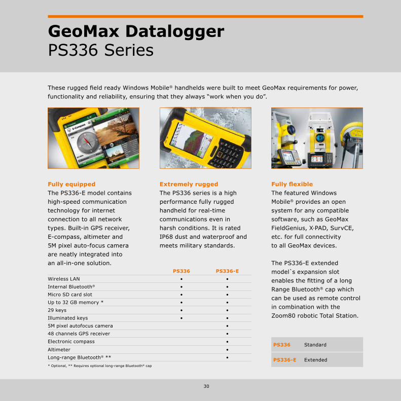
Fully equippedThe PS336-E model contains high-speed communication technology for internet connection to all network types. Built-in GPS receiver, E-compass, altimeter and 5M pixel auto-focus camera are neatly integrated into an all-in-one solution.
These rugged field ready Windows Mobile® handhelds were built to meet GeoMax requirements for power, functionality and reliability, ensuring that they always “work when you do”.
Extremely ruggedThe PS336 series is a high performance fully rugged handheld for real-time communications even in harsh conditions. It is rated IP68 dust and waterproof and meets military standards.
Fully flexibleThe featured Windows Mobile® provides an open system for any compatible software, such as GeoMax FieldGenius, X·PAD, SurvCE, etc. for full connectivity to all GeoMax devices.
The PS336-E extended model s expansion slot enables the fitting of a long Range Bluetooth® cap which can be used as remote control in combination with the Zoom80 robotic Total Station.
PS336 Standard
PS336-E Extended
PS336 PS336-EWireless LAN • •Internal Bluetooth® • •Micro SD card slot • •Up to 32 GB memory * • •29 keys • •Illuminated keys • •5M pixel autofocus camera •48 channels GPS receiver •Electronic compass •
Altimeter •Long-range Bluetooth® ** •* Optional, ** Requires optional long-range Bluetooth® cap
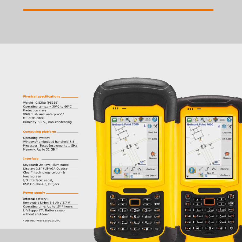
Physical specifications
Weight: 0.53 kg (PS336) Operating temp.: – 30°C to 60°C Protection class: IP68 dust- and waterproof / MIL-STD-810G Humidity: 95 %, non-condensing
Interface
Keyboard: 29 keys, illuminated Display: 3.5” Full-VGA Quadra-Clear™ technology colour- & touchscreen I/O interface: serial, USB On-The-Go, DC jack
Computing platform
Operating system: Windows® embedded handheld 6.5 Processor: Texas Instruments 1 GHz Memory: Up to 32 GB *
Power supply
Internal battery: Removable Li-Ion 5.6 Ah / 3.7 V Operating time: Up to 15** hours LifeSupport™: Battery swap without shutdown
* Optional, **New battery, at 20°C

32
GeoMax DataloggerZ710 for X•PAD Android
X•PAD for Android presents a new way of working, based on the most evolved and technologically advanced platform for mobile devices. For the first time, software designed for topographic survey and staking out in the field is available on Android with a wide range of user-friendly features. Used in conjunction with GeoMax instrumentation, X•PAD for Android will change your way of working forever.
Augmented reality. Get the full picture!How can augmented reality be a useful tool in topographic surveys and stake-out? Here’s how. Simply point the camera to the area of interest and you can immediately see where the points and elements to be staked out are. X•PAD will guide you to the vicinity of the point and then to the exact location. But you can also use augmented reality to see what is not visible, such as underground pipes, cables and connections. X•PAD allows you to integrate reality with your data.
The controller? It’s up to you.X•PAD for Android can be supplied with a rugged tablet, featuring a 7” touch screen with the breadth and brightness to give the display instant clarity, so you can view the data quickly and with minimum effort in all conditions. Or you can also opt to use the X•PAD on your existing tablet or smartphone. It all adds up to maximum flexibility for you, the user.
Your data on Google Maps.With X•PAD you can see your survey and your design superimposed on a satellite map via Google Maps at any stage. See your position on the map, check the position of your reference points or measure distances and surfaces directly from CAD. This facility offers a revolutionary way of working.

33
GeoMax Z710X·PAD Android on the Z710 tablet can be used for all GeoMax Zenith GNSS antennas as well as manual and motorised Zoom Total Stations.
CompactBuilt to house a brilliant 7’’ display, the Z710 comes with 800 g light and is small enough to hold with just one hand, yet big enough to help you get the job done.
The Z710 is specifically engineered to be protected against 2 m drops, shocks, spills, vibration and more. Equipped with tempered glass and a temperature range of – 20°C to 50°C.
Built-in GPS, combined with E-compass and 3-axis accelerometer, the Z710 is the perfect device for anyone using GPS data in the field.

34
GeoMax LocatorsEZiTEX Signal Transmitter
Delivering significantly higher power than previous model transmitters.
The enhanced performance enables: • Trace services over a greater
distance• Improved service detection
in areas of high signal interference
• Improved depth estimation when using a depth locator
FlexibilityCompact design with an IP65 rating, the transmitter is fully protected even in the harshest of conditions.
Benefits• Four adjustable output
levels, deliver a maximum output level of 1 watt
• Durable weatherproof design• Environmental protection
rating of IP65 with robust, compact and lightweight design engineered for tough site conditions
• Choice of 3 tracing signals
• 33 kHz everyday site use, generally accepted as an industry standard
• 8 kHz long tracing and reduced cross coupling
• 8 and 33 kHz (connection mode)
• Ease of use. Default output frequency of 33 kHz
• Externally located clear, audio visual controls, ensuring a robust waterproof design
• Built-in test function, allowing operators to test the hardware and software functionality of the EZiTEX before use
EZiTEX t100
Operating transmission frequencies 8 & 33 kHz, mixed 8/33 Output power 4 levelsInduction (Max) Up to 1 W maxDirect connection (300 Ohms) Up to 1 W max when connected to a buried service with anBattery type 4 x D alkaline (IEC LR20), suppliedBattery life (typical use at 20°C) 30 hours intermittent useWeight 2.4 kg including batteriesDimensions (H x D x W) 105 mm x 190 mm x 235 mm IP rating (case lid closed) IP65IP rating (case lid open) IP54

35
GeoMax LocatorsEZiCAT Series
Obtaining accurate information about the location of buried utilities has never been more essential to protect employees and equipment during any excavation project.
How does the EZiCAT locate?The EZiCAT range locates buried utilities by receiving electromagnetic signals which radiate from them.
The EZiCAT’s intelligent software interprets the signal data and provides the operator with an audible and visual response to the location and direction of buried utilities.
EZiCAT i500
Frequency / mode Power mode 50 Hz or 60 Hz, radio mode 15 kHz to 60 kHz Transmitter mode 8 kHz and 33 kHz, Auto mode = Power + radio mode Depth Power to 3 m, radio to 2 m, transmitter mode to 3 m Protection Conforms to IP54
EZiCAT i550
Frequency / Mode Power mode 50 Hz or 60 Hz, radio mode 15 kHz to 60 kHz Transmitter mode 8 kHz and 33 kHz, Auto mode = power + radio mode Depth Power to 3 m, radio to 2 m, transmitter mode to 3 m Depth Estimation 10 % of depth in line or sonde (0.3 to 3 m depth range) Protection Conforms to IP54
EZiCAT i650
Frequency / mode Power mode 50 Hz or 60 Hz, Radio mode 15 kHz to 60 kHz Transmitter mode 8 kHz and 33 kHz, Auto mode = power + radio mode Depth Power to 3 m, radio to 2 m, transmitter mode to 3 m Depth estimation 10 % of depth in line or sonde (0.3 to 3 m depth range) Protection Conforms to IP54 Compatibility CSV file compatibility program Memory size 32 MB memory Capacity 80 hours of data
36
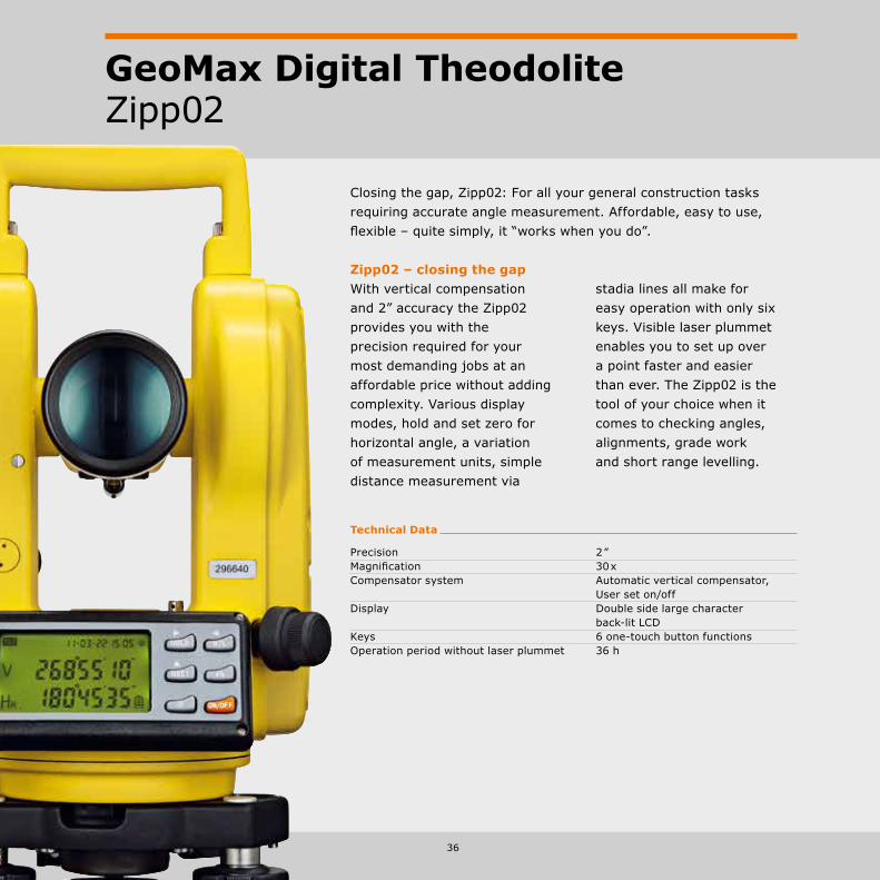
GeoMax Digital TheodoliteZipp02
Technical Data
Precision 2 ” Magnification 30 x Compensator system Automatic vertical compensator, User set on/off Display Double side large character back-lit LCD Keys 6 one-touch button functions Operation period without laser plummet 36 h
Closing the gap, Zipp02: For all your general construction tasks requiring accurate angle measurement. Affordable, easy to use, flexible – quite simply, it “works when you do”.
Zipp02 – closing the gapWith vertical compensation and 2” accuracy the Zipp02 provides you with the precision required for your most demanding jobs at an affordable price without adding complexity. Various display modes, hold and set zero for horizontal angle, a variation of measurement units, simple distance measurement via
stadia lines all make for easy operation with only six keys. Visible laser plummet enables you to set up over a point faster and easier than ever. The Zipp02 is the tool of your choice when it comes to checking angles, alignments, grade work and short range levelling.

37
GeoMax Digital LevelZDL700 Series
At GeoMax we understand that you require accurate results and demand ease of use in combination with fast operation. That’s why we’ve introduced the ZDL700 digital level for the surveying and construction world. Now you can ‘go digital’ for your entire levelling task with a product that delivers outstanding price-performance and “works when you do!”.
Technical Data
Height accuracy ± 0.7 mm/km Distance accuracy D < 10 m, 10 mm D ≥ 10 m, 0.001 x D Maximum range 105 m Single measurement speed < 3 seconds Internal memory 2,000 measurements
Quick, easy & error-freeThe super fast measurement speed of less than 3 seconds in combination with the simplicity of the one-push measure and store functionality provides faster, more economical workflows. Digital reading combined with internal memory make misreadings and operator interpretation errors a thing of the past.
AccurateExtensive field tests verify the excellent accuracy of the ZDL700 of 0.7 mm for 1 km double-run level. This makes the ZDL700 an ideal level not only for high order levelling but also deformation measurements and precise surveying, as well as general construction.
Leave the calculator in your pocketThe onboard adjustment program, height difference calculation, inverse staff measuring mode, in combination with various measuring configurations
enable you to execute all calculations with the ZDL700. Based on digital readings and automated calculation, you will never again be slowed down by time-consuming calculator usage.

38
GeoMax Automatic LevelZAL300 Series
Get all your tasks done with GeoMax’s flagship level. From daily levelling tasks to high accuracy, the ZAL300 Series is your first choice when robustness, comfort and accuracy count. It simply “works when you do!”
Flexible and ergonomicWith four different types of magnifications, 20x, 24x, 28x and 30x, the ZAL300 series offers the accuracy of your choice. The patented magneX™ compensator system from GeoMax used in the ZAL300 series with magnetic dampening makes stuck a thing of the past.
Technical Data
Magnification 30 x 28 x 24 x 20 x Minimum focusing distance 0.8 m 0.6 m Compensator damping system magneX™, automatic, magnetic-damped Standard deviation 1.2 mm 1.5 mm 2.0 mm 2.5 mm for 1km double-run levelling Horizontal fine motion screws Double-sided endless drive Dust and water resistance Conforms to IP57 (Gas filled telescope) Base / base screw Concave and flat / 5/8 ”
ZAL330 ZAL328 ZAL324 ZAL320
IP57 Waterproof
Bubble mirror
Selectable 360 °/400gon horizontal circle
Endless fine drive
Gas filledtelescope body
20 x / 24 x / 28 x / 30 x Magnification
MagneX™ Magnetic-damped compensator
Focusing knob

39
GeoMax Automatic LevelZAL100 Series
Suitable for outdoor as well as for indoor use the user friendly ZAL100 Auto Level Series from GeoMax is your guarantee to get the job done, accurately and on time.
Technical Data
Magnification 32 x 28 x 24 x 20 xImage ErectMinimum focusing distance < 1.0 mCompensator damping system Automatic, air-dampedStandard deviation 2.0 mm 2.5 mm for 1km double-run levelling Graduation / intervals 360 ° / 1 °Horizontal fine motion screws Double-sided endless driveDust and water resistance Conforms to IP54 (IEC60529)Base / base screw Concave and flat / 5/8 ”
focusing knob
32x / 28x / 24 x / 20 x magnification IP54 waterproof
bubble mirror
air-dampedcompensator
endless fine drive
adjustable 360 ° horizontal circle
Built to lastWith the ZAL100 Series, GeoMax introduces an auto-matic level to the construc-tion industry that is designed for your daily levelling tasks with an outstanding price-to-performance ratio. Meeting the IP54 class specifications guar-antees waterproofing of the ZAL100 Series and provides you with an instrument that “works when you do!”.
ZAL132 ZAL128 ZAL124 ZAL120

40
Technical Data
Range 300 m (diameter) Levelling range ± 10 % Levelling h & v auto h auto & h auto v semi-auto Accuracy (at 30 m) h: ± 3 mm h: ± 3 mm h: ± 3 mm v: ± 3 mm v: ± 10 mm v: N.A. Tilt alert control yes Battery 2 Alkaline D size, 160 hours, NiMh rechargeable 50 hours Detector/remote control ZDR300 Detector w. ZDT200 integrated remote control Detector
GeoMax Laser RotatorZEL400 Series
With its proven performance the ZEL400 laser rotator series covers the whole range from internal applications to general construction – a true multi-purpose tool.
Solid & economicTotally automatic thus easy and fast to setup, and in combination with advanced technology, GeoMax delivers a laser rotator with outstanding
ZEL400HV ZEL400H+ ZEL400H
price-to-performance ratio. Its ruggedized design, protected head and waterproof housing makes the ZEL400 series the tool for all your tasks that “works when you do!”.
Vertical plumb
Head protection
Highly visible beam
Waterproof housing
Hand detector & remote control
Tilt func-tion
Adjustablefootscrews
Rubberbumpers
Non-slip rubber handle

41
GeoMax Laser RotatorZLT300/200 Series
At GeoMax we understand that your equipment should be as flexible as you are. With the ZLT300 and ZLT200, we introduce a series of multi-purpose lasers that cover the entire range from machine control, site work, pipe laying to interior finishing.
We level, you workNow is the time to stop chasing bubbles to get your job levelled. And the good thing is that you are only one button push away. From site work and levelling to alignment, pipe laying, interior finishing and civil engineering projects, the ZLT300 and ZLT200 are the partners that help you to get the job done in time, with the required accuracy and dependability. And all of this with the price-to-performance ratio GeoMax is known for.
Dual grade slopesWith manually adjustable grades, you can simply match slopes in one or two axis by using the laser in manual mode. While used on one man-ual slope, the automatic cross axis self levelling provides you with maximum security.
Technical Data
Range 800 m (diameter) Levelling range ± 8 % ± 5 °Levelling Automatic horizontal Automatic horizontal and vertical Accuracy ±10 mm at 100 m Tilt alert control User definable laser shut-off Laser battery life 50 h with internal rechargeable NiMH battery Environmental IP67 waterproofDetector/remote control ZDR300 Detector ZDT200 Detector with integrated remote control
ZLT300 ZLT200

42
GeoMax Laser RotatorZone50 Series
Featuring a fully automatic as well as an automatic model, the Zone50 Series provides the perfect match for any work site requiring highest precision, outstanding durability and extensive range.
Zone50 FAThe Zone50 FA is a fully au-tomatic dual grade laser with an aluminium-cast housing for withstanding even the harshest conditions. As a fully automatic laser, it not only constantly checks but also permanently readjusts the de-fined grade to ensure highest accuracy and dependability.
Zone50 AThe Zone50 A is an Automatic laser with grade capability. Equipped with the same sturdy aluminium-cast housing and IP class 67 as the Zone50 FA, this laser is built to last on any jobsite under any condi-tions. With more than 100 m range for the remote and 300 m laser radius, the Zone50 A provides you with an extensive work range.
Technical Data
Range Depends on receiver: >250m radius>500m radius (Laser class 3R) >300m radius (Laser class 2)
Levelling range ± 5 ° Levelling -15% up to 15% -10% up to 10% Accuracy ±5mm at 100 m Tilt alert control yes Battery NiMH; changing 4h Environmental IP67 dust and waterproof Detector/remote control (FAR) RG50FA (AR) RG50A
Zone50 FA Zone50 A
> 100 m Remote range
Alignment telescope (optional) Independent X and Y adjustment
IP67 Dust & waterproof
> 400 m Remote range
Slope range ±15%
Tilt control HiAlert
Slope range ± 10 %
> 500 m Radius workrange (3R)> 300 m Radius workrange (2)
> 300 m Radius workrange
Sector lock
Rotation speed 0/600/800 upm
Rotation speed 0/600/1,000 upm
Metal housing
Sector lock

43
Precision input of slopesEnter your slopes in a range of ± 15 % (± 10 % for Zone50 A) with highest precision either via the remote unit or directly at the laser.
Dual or single gradeAll lasers of the Zone50 Series allow you to use two independent axes to define your grade values providing you full flexibility on complex jobs.
Sector lock –beam maskingElectronically turns off the laser beam in specific quadrants to prevent interference with other crews on the site. Can also be used to avoid shining into a roadway or to avoid reflective surfaces, which may give a false reading.
Remote controlThe RG50FA and RG50A optional remote controls provide a range of more than 400 m and 100 m radius. All functions of the laser can be controlled via the remote. Even a reactivation of the rotation following a tilt sensor stop is possible via the remote. Users can easily run several lasers in parallel on the same site by pairing the laser with the remote control.
Control functionEquipped with tilt-control function, the Zone50 lasers will be switched off automatically if displaced inadvertently or disturbed significantly by wind. Lower sensitivity settings towards wind & vibrations can be selected to allow continuous operation and are supported by an automatic re-adjustment.

44
GeoMax SoftwareFull flexibility in software
GeoMax FieldGenius Premium FieldGenius has evolved into the most powerful and productive data collector in the land surveying market.
X·PAD Survey and X·PAD Construction With X·PAD, productivity and flexibility in the field are assured due to an easy user-interface and to highly innovative contents.
GeoMax Geo OfficeThe ideal office software companion for your GeoMax field equipment. With complete seamless dataflow, your field results are effortlessly transferred to the office environment ready for further processing, CAD creation or direct delivery to clients.
GeoMax Layout ProAn easy-to-use graphical field product designed specifically for the construction layout professional.
X·PAD AndroidX·PAD Surveying and Construction for Android presents a new way of working, based on the most evolved and technologically advanced platform for mobile devices.
45
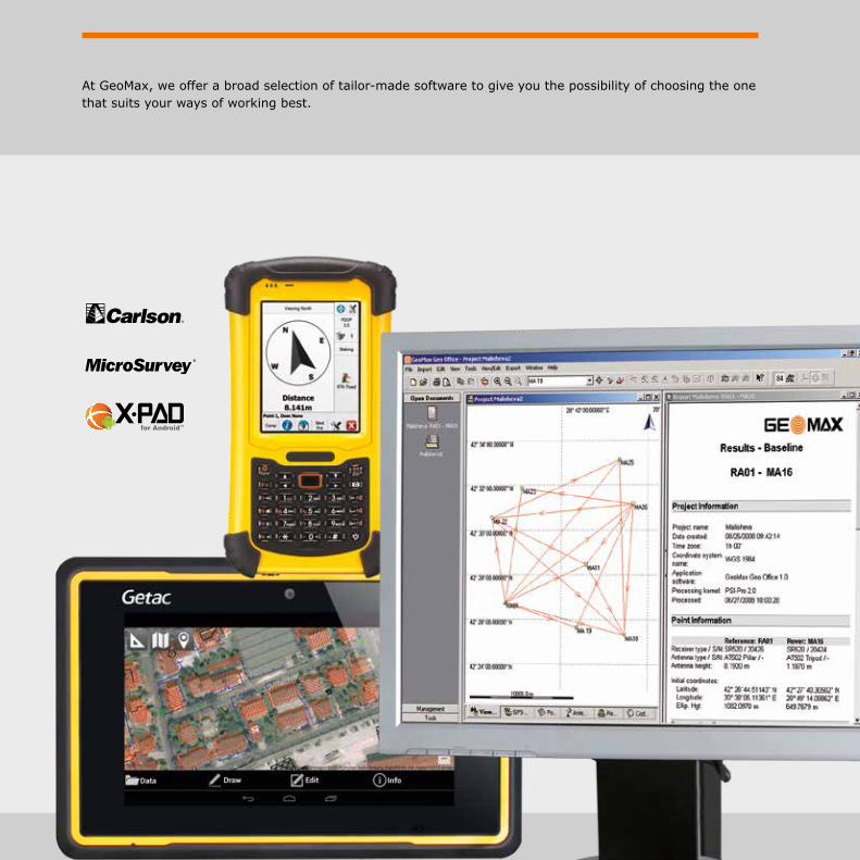
At GeoMax, we offer a broad selection of tailor-made software to give you the possibility of choosing the one that suits your ways of working best.

46
GeoMax SoftwareGGO – GeoMax Geo Office
GeoMax Geo Office (GGO) is the ideal office software companion for your GeoMax field equipment. With complete seamless dataflow, your field results are effortlessly transferred to the office environment ready for further processing, CAD creation or direct delivery to clients.
Easy-to-useFollowing Microsoft Windows standards, GGO is easy-to-use, even for novice PC users. Through use of icons and graphics working with data in GGO is as easy as “point and click”.
Data processing and reportingWhen post-processing of GNSS (GPS+GLONASS) data is required, GGO provides state-of-the-art technology to guarantee you always produce optimal results. No special knowledge of GNSS is required; simply import data and GGO will automatically process all possible GNSS baselines. Once results are available they can be simply presented in customised reports ensuring you need no further preparations, and your results are ready for clients.
Prepare, visualize and editGGO has a full suite of tools that allow you to get the most out of your equipment before going on-site. With a little preparation, you’re ready to be fully productive to work the way you work. Once you’ve completed your survey and seamlessly imported your field results into GGO, all observations are immediately available for visual confirmation of field activities. If errors or changes are found they can be easily edited to deliver perfect results.
RINEX Import/ExportSupport of GNSS processing using multiple sensor brands is assured thanks the GGO’s RINEX Import/Export option. By using the industry standard RINEX format you can import third party receiver data and post-process in GeoMax Geo Office.

GeoMax GGO
47
Least squares adjustment A rigorous 3D least squares adjustment package is available in GeoMax Geo Office. This option allows the adjustment using least squares of GNSS, total station and combined data using a variety of different parameters and coordinate systems. The results are stored in well designed HTML reports.
48
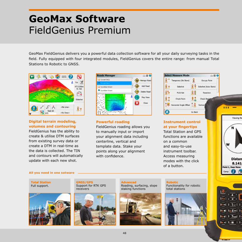
GeoMax SoftwareFieldGenius Premium
GeoMax FieldGenius delivers you a powerful data collection software for all your daily surveying tasks in the field. Fully equipped with four integrated modules, FieldGenius covers the entire range: from manual Total Stations to Robotic to GNSS.
Instrument control at your fingertipsTotal Station and GPS functions are available on a common and easy-to-use instrument toolbar. Access measuring modes with the click of a button.
Powerful roadingFieldGenius roading allows youto manually input or import your alignment data including centerline, vertical and template data. Stake your points along your alignment with confidence.
Digital terrain modeling,volumes and contouringFieldGenius has the ability to create & utilise DTM surfaces from existing survey data or create a DTM in real-time as the data is collected. The TIN and contours will automatically update with each new shot.
Total StationFull support.
GNSS/GPSSupport for RTK GPS receivers
AdvancedRoading, surfacing, slope staking functions
RoboticFunctionality for robotic total stations
All you need in one sotware
GeoMax Software Layout Pro
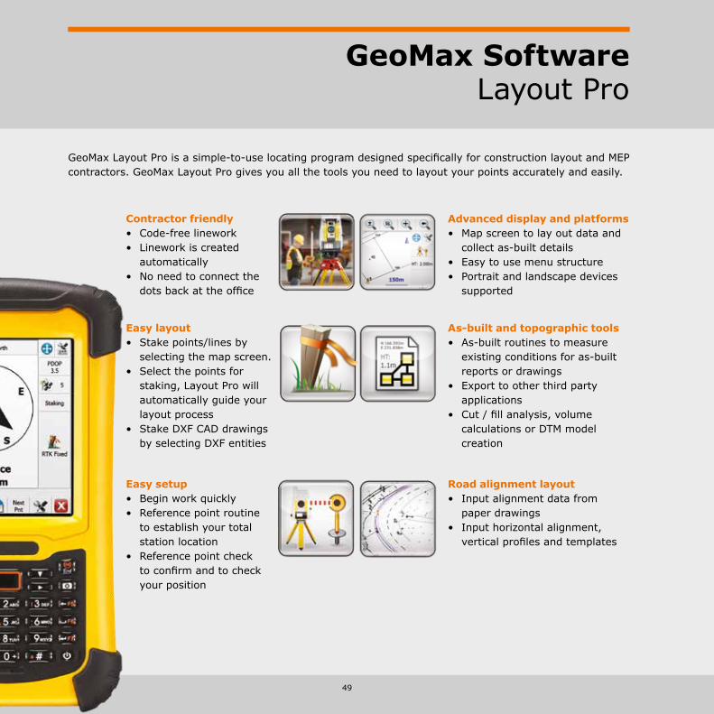
GeoMax Layout Pro is a simple-to-use locating program designed specifically for construction layout and MEP contractors. GeoMax Layout Pro gives you all the tools you need to layout your points accurately and easily.
49
Contractor friendly• Code-free linework• Linework is created
automatically• No need to connect the
dots back at the office
Easy layout• Stake points/lines by
selecting the map screen.• Select the points for
staking, Layout Pro will automatically guide your layout process
• Stake DXF CAD drawings by selecting DXF entities
Easy setup• Begin work quickly• Reference point routine
to establish your total station location
• Reference point check to confirm and to check your position
Advanced display and platforms• Map screen to lay out data and
collect as-built details• Easy to use menu structure• Portrait and landscape devices
supported
As-built and topographic tools• As-built routines to measure
existing conditions for as-built reports or drawings
• Export to other third party applications
• Cut / fill analysis, volume calculations or DTM model creation
Road alignment layout• Input alignment data from
paper drawings• Input horizontal alignment,
vertical profiles and templates
50
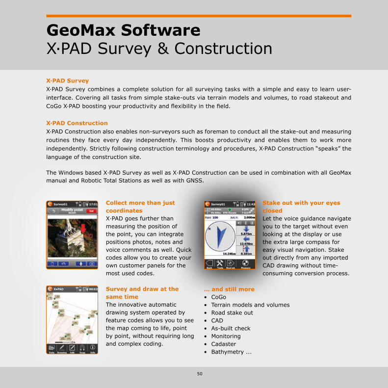
GeoMax SoftwareX·PAD Survey & Construction
X·PAD SurveyX·PAD Survey combines a complete solution for all surveying tasks with a simple and easy to learn user-interface. Covering all tasks from simple stake-outs via terrain models and volumes, to road stakeout and CoGo X·PAD boosting your productivity and flexibility in the field.
X·PAD ConstructionX·PAD Construction also enables non-surveyors such as foreman to conduct all the stake-out and measuring routines they face every day independently. This boosts productivity and enables them to work more independently. Strictly following construction terminology and procedures, X·PAD Construction “speaks” the language of the construction site.
The Windows based X·PAD Survey as well as X·PAD Construction can be used in combination with all GeoMax manual and Robotic Total Stations as well as with GNSS.
Collect more than just coordinatesX·PAD goes further than measuring the position of the point, you can integrate positions photos, notes and voice comments as well. Quick codes allow you to create your own customer panels for the most used codes.
Survey and draw at the same timeThe innovative automatic drawing system operated by feature codes allows you to see the map coming to life, point by point, without requiring long and complex coding.
Stake out with your eyes closedLet the voice guidance navigate you to the target without even looking at the display or use the extra large compass for easy visual navigation. Stake out directly from any imported CAD drawing without time-consuming conversion process.
… and still more• CoGo• Terrain models and volumes• Road stake out• CAD• As-built check• Monitoring• Cadaster• Bathymetry ...

GeoMax Software X·PAD Android
51
X·PAD for Android is the world’s first professional surveying and construction software base on Android. It presents a new way of working based on the most evolved and technologically advanced platform for mobile devices. X·PAD for Android offers all the known feature of its Windows equivalent and even more. Used in conjunction with the GeoMax manual and robotic Total Stations as well as with the GNSS X·PAD Android will change your way of working.
Augmented reality - get the full pictureSimply point the camera to the area of interest to see the elements to stake.
Your data on Google mapsSuperimpose your data on a satellite image via Google maps at any stage of your project to check for reference points or measure directly in the drawing.
Finding your project- as simple as thatDon’t remember the name of file, but know when and where it was done? Simply chose your project via location on Google maps or on the calendar.

52
GeoMax Accessories
Dependable work demands dependable accessories. We recommend the individually tested GeoMax acces-sory selection for best performance in all your tasks. Of a quality that meets the highest demands, you can be assured that the complete range of GeoMax accessories “work when you do!”.
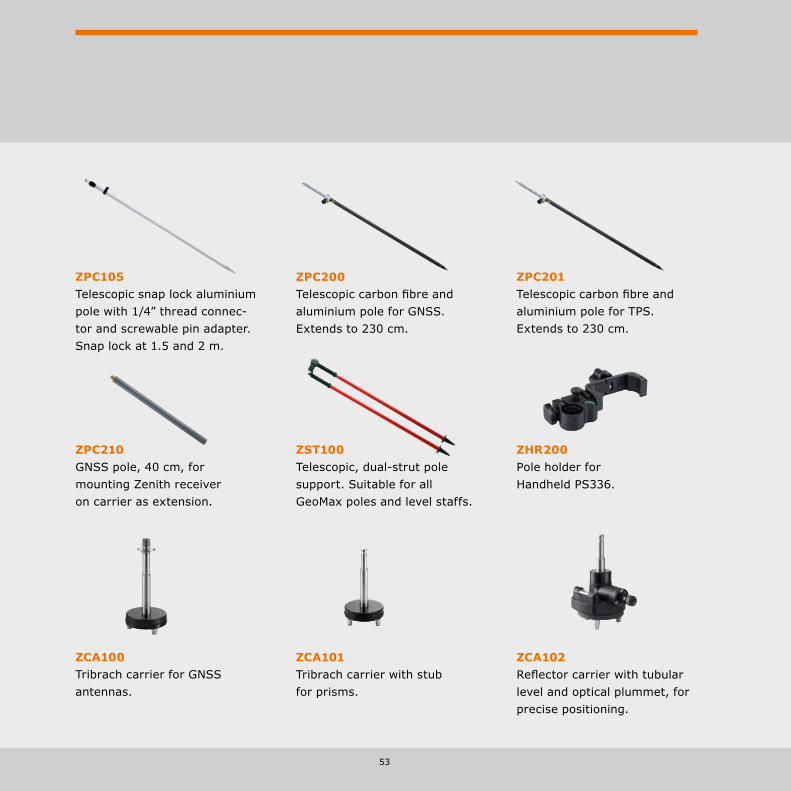
ZTW100Wooden tripod with shoulder strap and side clamp screws, 104 cm packaged length, extendible to 166 cm, weight 5.7 kg.
ZTA100Aluminium light weight tripod with shoulder strap and side clamp screws, 105 cm packaged length, extendible to 167 cm, weight 4.5 kg.
ZST101Tripod-star, for setting up of tripods on hard and slippery surfaces.
ZTR101Tribrach without optical plummet, black.ZTR103Tribrach with optical plummet, black.
53
ZCA102Reflector carrier with tubular level and optical plummet, for precise positioning.
ZPC200Telescopic carbon fibre and aluminium pole for GNSS. Extends to 230 cm.
ZHR200Pole holder for Handheld PS336.
ZST100Telescopic, dual-strut pole support. Suitable for all GeoMax poles and level staffs.
ZCA101Tribrach carrier with stub for prisms.
ZPC210GNSS pole, 40 cm, for mounting Zenith receiver on carrier as extension.
ZPC201Telescopic carbon fibre and aluminium pole for TPS. Extends to 230 cm.
ZPC105Telescopic snap lock aluminium pole with 1/4” thread connec-tor and screwable pin adapter. Snap lock at 1.5 and 2 m.
ZCA100Tribrach carrier for GNSS antennas.

54
GeoMax Accessories
ZSA504Four-section telescopic staff. Provides dual measuring faces with bar code and millimetre graduations.
ZSF301Dual face high accuracy fibreglass levelling staff, 3 m, 1 section, barcode/E-Scale cm-graduation, with circular bubble and handle. ZSE504Level staff 5 m, 4 sections, front side with E-graduation and back side with mm-graduation.
GRZ122360° prism with 5/8” for GNSS antenna.
ZPR100 and ZTP100Circular prism with red holder, 0-offset. The ZTP100 target plate for precise aiming over long distances is separately available.
GRZ4360° prism with soft bag.
ZDE100/GFZ4 Diagonal eyepiece.
ZMP100Mini prism 0-constant with tip, fits to ZPC105 pole.
ZPM100Sliding mini-prism. True 0-constant prism, includes bubble, 4 mini poles and pole tip.
ZTM100Self-adhesive reflective target 6 x 6 cm. For measurement of surfaces with standard EDM.
55
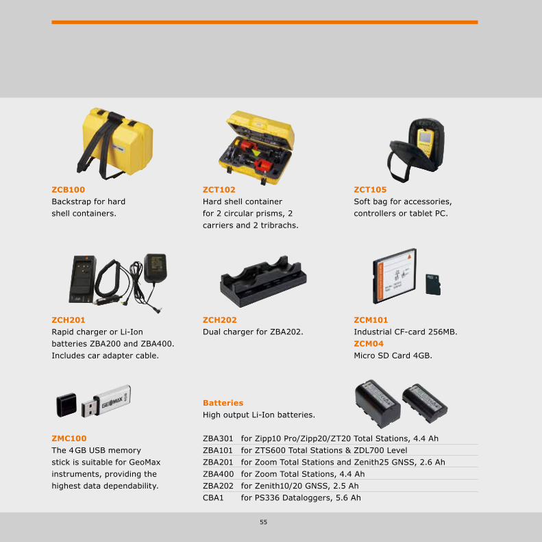
ZCT102Hard shell container for 2 circular prisms, 2 carriers and 2 tribrachs.
ZCB100Backstrap for hard shell containers.
ZCH201Rapid charger or Li-Ion batteries ZBA200 and ZBA400. Includes car adapter cable.
BatteriesHigh output Li-Ion batteries.
ZBA301 for Zipp10 Pro/Zipp20/ZT20 Total Stations, 4.4 Ah ZBA101 for ZTS600 Total Stations & ZDL700 Level ZBA201 for Zoom Total Stations and Zenith25 GNSS, 2.6 Ah ZBA400 for Zoom Total Stations, 4.4 Ah ZBA202 for Zenith10/20 GNSS, 2.5 Ah CBA1 for PS336 Dataloggers, 5.6 Ah
ZCM101Industrial CF-card 256MB.ZCM04Micro SD Card 4GB.
ZMC100The 4 GB USB memory stick is suitable for GeoMax instruments, providing the highest data dependability.
ZCT105Soft bag for accessories, controllers or tablet PC.
ZCH202Dual charger for ZBA202.
56
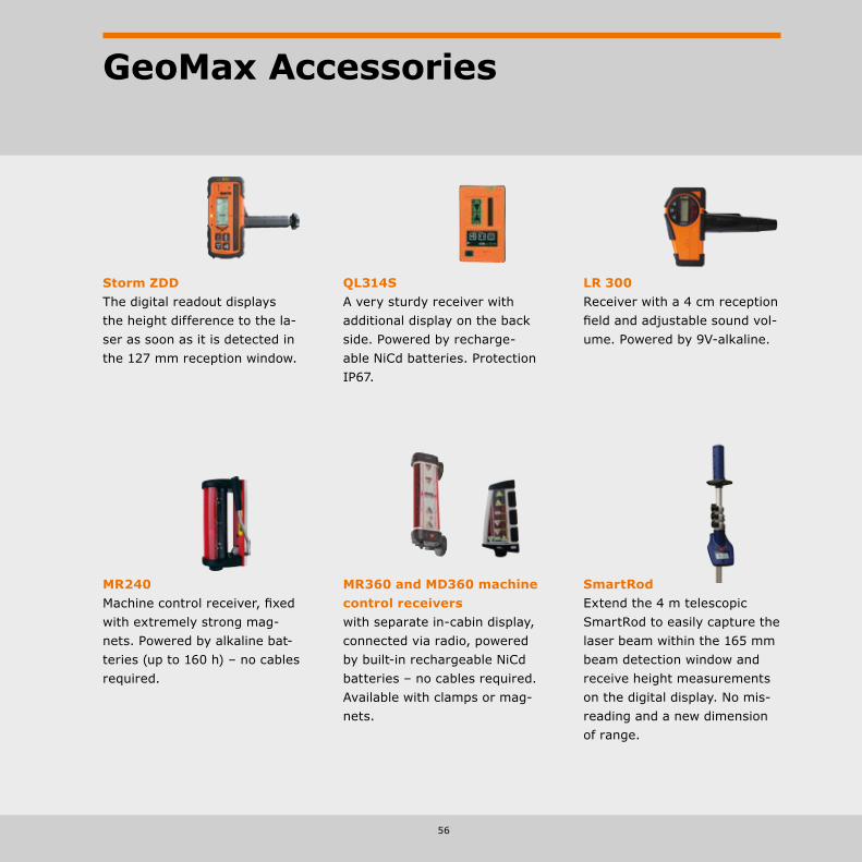
GeoMax Accessories
Storm ZDDThe digital readout displays the height difference to the la-ser as soon as it is detected in the 127 mm reception window.
QL314SA very sturdy receiver with additional display on the back side. Powered by recharge-able NiCd batteries. Protection IP67.
LR 300Receiver with a 4 cm reception field and adjustable sound vol-ume. Powered by 9V-alkaline.
MR240Machine control receiver, fixed with extremely strong mag-nets. Powered by alkaline bat-teries (up to 160 h) – no cables required.
MR360 and MD360 machine control receivers with separate in-cabin display, connected via radio, powered by built-in rechargeable NiCd batteries – no cables required. Available with clamps or mag-nets.
SmartRodExtend the 4 m telescopic SmartRod to easily capture the laser beam within the 165 mm beam detection window and receive height measurements on the digital display. No mis-reading and a new dimension of range.

57
GeoMax Accesories
Total Station, Controller & Digital Level
Zipp10 Pro/Zipp20 USB Cable mini-USB to USB host connecting Zipp10 to a PC/Tablet. ZDC301Zoom20/30/35 Pro RS232 Cable Hirose-RS232 connecting Zoom20/30/35 (Pro) ZDC100 to a PC/Tablet using serial transfer technology. USB Cable Lemo-USB connecting Zoom20/30/35 (Pro) ZDC217 to a PC/Tablet using USB transfer technology.ZTS600, ZDL700 RS232 Cable Hirose-RS232 connecting ZTS600 & ZDL700 to a PC/Tablet. ZDC100 USB Cable Lemo-USB connecting ZTS600 & ZDL700 to a PC/Tablet ZDC102
Cables
GNSS
Zenith10/20 USB Cable Lemo-USB for Zenith10/20 connecting the device to a PC/Tablet. ZDC222 RS232 Cable Lemo-RS232 for Zenith10/20 connecting the device to a PC/Tablet. ZDC220 Satel EASyPro/battery Y-Cable Lemo to Lemo and clamps to connect Zenith10/20 ZDC221 with Satel EASyPro radio and external battery for power supply. Zenith25 RS232 Cable Lemo-RS232 for connecting Zenith25 to a PC/Tablet. ZDC227 USB Cable Lemo-USB for connecting Zenith25 to a PC/Tablet. ZDC226 Satel EASyPro/battery Y-Cable Lemo to Lemo and clamps to connect Zenith25 ZDC225 with Satel EASyPro radio and external battery for power supply.TNC TNC TNC to TNC cable. 2m extension for radio antenna. ZDC202

Distance meter (Reflector mode): Laser class 1 in accordance with IEC 60825-1 resp. EN 60825-1
Laser plummet: Laser class 2 in accordance with IEC 60825-1 resp. EN 60825-1
Distance meter (Reflectorless mode accXess™): Laser class 3R in accordance with IEC 60825-1 resp. EN 60825-1
Built for all environmentsWith the design criteria “works when you do!” GeoMax products are built to withstand all environmental conditions. GeoMax equipment is built with the intention to withstand all conditions you run into during your daily work. Rain, hail, snow or intense heat will never affect your GeoMax equipment - you can always keep working to get the job done.
Our commitment to qualityThe internationally active Swiss Association for Quality and Management Systems SQS, as well as the International Certification Network IQNET certified that GeoMax AG meets the requirements of ISO9001, Quality Management System and ISO14001, Environmental Management System.- Certified area:
Whole company.- Field of activity:
Development, manufacture, distribute, support and service of products, precision tools and systems for geomatic, industrial and construction applications.
Our commitment to safety and the environmentAll GeoMax products are fully CE (Conformité Européenne) as well as RoHS (Restriction of the use of certain hazardous substances in electrical and electronic equipment) and WEEE (Waste from Electrical and Electronic Equipment) conformant.
Windows® CE, Windows® 7, Windows® Embedded, and Windows® Mobile are registered trademarks of Microsoft Corporation. The Bluetooth® word mark and logos are owned by Bluetooth SIG. NovAtel OnBoard® is a registered trademark of NovAtel Inc.Other trademarks and trade names are those of their respective owners.
GeoMax Quality Management
58

59
Notes

GeoMax Total StationZipp10 Series
ZIP
P10
ZA
L30
0
GeoMax Automatic LevelZAL300 Series
GeoMax Automatic LevelZAL100 Series
Wor
ks w
hen
you
do
Digital TheodoliteZipp02
Automatic Level ZAL300 Series
Automatic Level ZAL100 Series
Laser Rotator ZEL400 Series
GeoMax Digital LevelZDL700 Series
Wor
ks w
hen
you
do
Digital Level ZDL700 Series
GeoMax Cable Locating System
Easy Connectivity • USB Memory Stick• Fast & Easy Data Transfer• Plug ’n Play Technology
Performance, Robustness• 250 m Non-Prism Range• Coaxial Visible Laserbeam• Sealed Durable Housing
Multifunctional Keyboard • Direct Access to Apps• Fast Navigation• Brilliant Readability
Manual Total StationZipp10 Pro Series
ZIP
P10
PR
O
GeoMax Laser RotatorZLT300/200 Series
Wor
ks w
hen
you
do
Laser Rotator ZLT300/200 Series
GeoMax Laser RotatorZEL400 Series
Wor
ks w
hen
you
do
GNSS Zenith25 Pro Series
Total Station Zoom35 Pro Series
Colour- & Touchscreen • Large 3.5″ Q-VGA Display• Fast Navigation• Brilliant Readability
Highest Functionality • NavLight™ Alignment Aid• 600m Non-Prism Range• 3 mm + 2 ppm Reflectorless
Easy Connectivity • USB Memory Stick• Bluetooth® Transfer• Plug ’n Play Technology
Manual Total StationZoom30 Pro Series
ZOO
M30
PR
O
Superior accXess10 EDM • > 1,000 m Non-Prism Range• > 10,000 m Prism Range• Pin Size Laser Beam
Easy Connectivity • USB Memory Stick• Bluetooth® Transfer• Plug ’n Play Technology
Colour Touch Screen • Large 3.5″ Q-VGA Display• Fast Navigation• Brilliant Readability
Manual Total StationZoom35 Pro Series
ZOO
M35
PR
O
GeoMax Cable Locating System
EZiS
YS
TEM
STReAM360 • S cout – Auto Find• TR ack – Auto Tracking• A i M – Auto Targeting
Long Range Bluetooth • High-Speed Data Link• Reliable Connectivity• License Free
Powerful Handheld • Inbuilt Camera (5 M Pixel)• Compass & Altimeter• Long-range Bluetooth®
Robotic Total StationZoom80 Series
Totally open Windows® CE• Supports any field software• Open for own development• Personalise your system
Totally connected• Integrated Bluetooth®
• USB memory stick• Plug and Play technology
Totally featured • 3.5’’ colour & touch display• 400 m non-prism range• Coaxial visible laser beam
Manual Total StationZipp20 – Open WinCE® Series
ZIP
P20
Compatta• Radio UHF Integrata• Modulo GSM/GPRS Integrato• Memoria Interna Extra Large
Fisso • IP67 resistente a polvere e acqua • Design Robusto• Professionale
Completo• 60 Satelliti Tracciati
Simultaneamente• GNSS: GPS, Glonass,
Galileo, BeiDou• NovAtel AdVance®
Ricevitore GNSS Serie Zenith10 & Zenith20
ZEN
ITH
10
& 2
0Extremely rugged • IP68 dust and waterproof• Withstands a 2 m drop• Vibration resistant
Future-proof• Quad-/penta band
GSM/GPRS/UMTS• UHF radio and Bluetooth®
• True GNSS: GPS, GLONASS, BeiDou, Galileo & SBAS
Versatile handheld • Camera, compass, altimeter• Meets military standards• Optimised for GeoMax
GNSS ReceiverZenith25 Pro Series
ZEN
ITH
25 P
RO
GeoMax [email protected]
Copyright GeoMax AG. Illustrations, descriptions and technical specifications are not binding and may change. Printed in Germany / 10.2014 / 768325en
Total Station Zoom80 Series
Total Station Zoom30 Pro Series
Total Station Zipp10 Pro Series
Total Station Zoom20 Pro Series
GeoMax Brochure Basket
Total Station Zipp20 Open WinCE® Series
GNSS Zenith10 & 20 Series