geonetwork for spatial data
TRANSCRIPT

Geonetwork for Spatial Data
Nizam-ud-Din
GIS Manager

Outlines• What is SDI?
• Geonetwork
• Objective
• Main Goal
• Geonetwork Main Features
• Geonetwork Functionality
• Goenetwork Evolution
• Geonetwork Standards
• Geonetwork Integration Example (FAO)
• Why necessary?
1
Geonetwork for Spatial Data

What is SDI?
“…the technology, policies, standards, and
human resource necessary to acquire, process,
store, distribute, and improve the utilization of
geospatial data.”
2
Geonetwork for Spatial Data

What is SDI?
“[Spatial Data Infrastructure]
provides a basis for spatial data
discovery, evaluation, and
application for users and providers
within all levels of government, the
commercial sector, the non-profit
sector, academia and by citizens in
general.”
3
Geonetwork for Spatial Data
Geonetwork
Geonetwork open source is a standard based and
decentralized spatial information management system,
designed to enable access to geo-referenced databases
and cartographic products from a variety of data
providing through descriptive metadata, enhancing the
spatial information exchange and sharing between
organizations and their audience, using capacities and
the power of the internet.
4
Geonetwork for Spatial Data

Objective5
The main goal of the software is to increase collaboration within
and between organizations for reducing duplication and
enhancing information consistency and quality and to improve
the accessibility of a wide variety of geographic information
along with the associated information, organized and
documented in a standard and consistent way.
Geonetwork for Spatial Data

Main Goal6
Geonetwork for Spatial Data
• Provide a common platform and standards to managegeographic data
• Improve accessibility and sharing of a wide variety ofgeographic data at different scale and from multidisciplinarysources
• Increase collaboration between UU and other local/nationalorganizations for collecting data and make them available tothe internet community

Geonetwork Evolution7
Geonetwork for Spatial Data
• Prototyping by FAO (2000-2001)
• Version 1 by FAO & WFP (released 2003)
• Version 2 by FAO, WFP & UNEP (released 2005)
• Version 2.1 by FAO & UNOCHA (Oct 2007)
• Version 3.0 (2008)
• Version 3.2.0 Presently

Geonetwork Standards
• Geonetwork implements widely accepted standards
• Interoperability
• Using standard web technologies to share data online
• The International Standard for Geographic Metadata - ISO19115
• OpenGIS Consortium standards(dynamic internet map services, catalogue services etc.)
8
Geonetwork for Spatial Data

ISO/DIS 191159
Geonetwork for Spatial Data
This new international standard defines the schema required for describing geographic information and services. It provides information about:
• identification;
• extent;
• quality;
• spatial;
• temporal schema;
• spatial reference;
• distribution …of digital geographic data.

Implementing Common Standards10
Geonetwork for Spatial Data
Standards for:
• Describing data;
• Finding data;
• Combining data

Geonetwork Privileges11
Geonetwork for Spatial Data
• View;
• Download;
• Edit;
• Delete;
• Administration;
• Dynamic View;

Geonetwork Main Features• Metadata and data publication and distribution
• Instant search on local and distributed geospatial catalogues
• Uploading and downloading of data, documents, PDF’s and any other content
• An interactive web map viewer that combines Web Map services from distributed servers around
the world
• Online editing of metadata with a powerful template system
• Scheduled harvesting and synchronization of metadata between distributed catalogues
• Groups and users management
• Different metadata standards
• Different sharing levels
• Fine grained access control
12
Geonetwork for Spatial Data

Geonetwork Functionality
• Searching of spatial data & services
• Downloading of data
• Online dynamic viewing through OGC services
• Metadata editor (template, validation)
• Users Management
• Synchronization/catalogue/distributed search
13
Geonetwork for Spatial Data

Search in Geonetwork node
Search Criteria
• Any (full text index)
• Title, abstract, keywords (advanced search)
• Exact search
• Simple geographic search (bbox)/selection of geographic area
• Selection by relevancy (modified, title, rating etc.)
• Group, Category, Site ….. & could be added
14
Geonetwork for Spatial Data

15
Geonetwork for Spatial Data
Geonetwork Interface – Local server

16
Geonetwork for Spatial Data
Search in Geonetwork node

17
Geonetwork for Spatial Data
Advanced Search
18
Geonetwork for Spatial Data
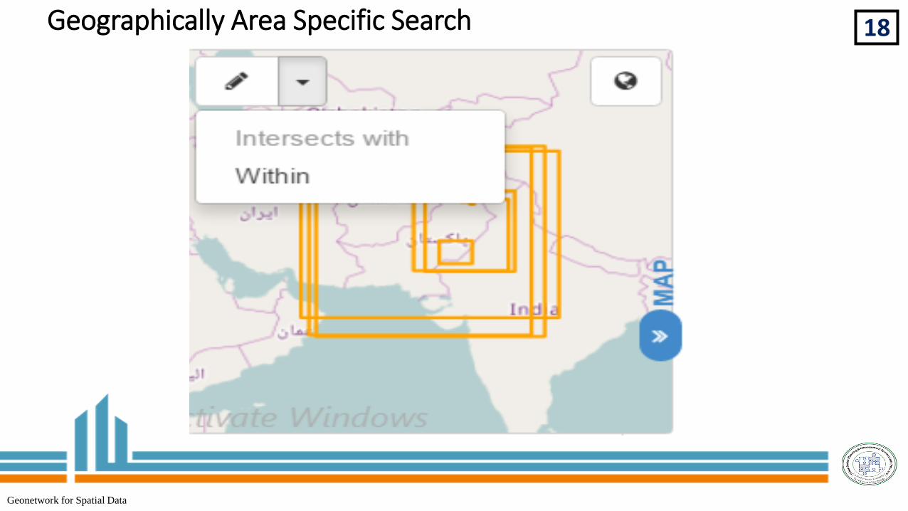
Geographically Area Specific Search

19
Geonetwork for Spatial Data
Sorted by Relevancy

20
Geonetwork for Spatial Data
Editing/interactive map/view/downloading functions

21
Geonetwork for Spatial Data

22
Geonetwork for Spatial Data
Administrative Rights

23
Geonetwork for Spatial Data
Metadata & templates

24Manage Directory/Category
Geonetwork for Spatial Data

25Statistics & Status

26
Geonetwork for Spatial Data
Statistics & Status

27
Geonetwork for Spatial Data
Statistics & Status

28
Geonetwork for Spatial Data
Reports

29
Geonetwork for Spatial Data
Food & Agriculture Organization (FAO) Interface-Example

30
Different links allow to extract
information from the Geographical
Server or to visualize the
metadata. The same GIS dataset
is used to generate the different
outputs.Metadata describing
the GIS dataset
ESRI shapefile file
KML file
Visualization of
the GIS dataset
Geonetwork for Spatial Data

Why Necessary?31
Geonetwork for Spatial Data
• Unique GIS repository for data integrity and maintenance purposes.
• Naming conventions, standardization and harmonization of GIS data
• Metadata provider application must be connected to the unique GIS repository
• Metadata software for describing data and facilitate dissemination
• Software based on international standards for data sharing
• Software accessible to non-developer users and easy to use.
• Applications based on server side for security reason and better performances.
• Extensibility to ease further developments.
• Metadata software for Minimization of duplication and redundancy.

What is Metadata?31
Geonetwork for Spatial Data
Metadata is data that describes geospatial data.
Metadata tells;owho, what, and when of a geospatial dataset.oWhat a dataset can’t show – data quality, history and availability.
Metadata can answers the following questions;oWhere did it originate?oWhat steps were followed to create it?oWhat attributes does it contain?oHow is the data projected?oWhat geographic area does it cover?oHow do I obtain the data?oEtc.

Why Care?31
Geonetwork for Spatial Data
It’s is a solution for data management.Metadata protects investment in data.Promotes data sharingHelps in minimize the costs incurred by data loss or by
creating data that already exists.