geonetwork user manual
TRANSCRIPT

GeoNetwork User ManualRelease 2.6.4
GeoNetwork
May 24, 2011


Contents
1 Preface 31.1 About this Project . . . . . . . . . . . . . . . . . . . . . . . . . . . . . . . . . . . . . 31.2 License Information . . . . . . . . . . . . . . . . . . . . . . . . . . . . . . . . . . . . 31.3 Author Information . . . . . . . . . . . . . . . . . . . . . . . . . . . . . . . . . . . . . 4
2 Quick Start Guide 52.1 Geographic Information Management for all . . . . . . . . . . . . . . . . . . . . . . . 52.2 Getting Started . . . . . . . . . . . . . . . . . . . . . . . . . . . . . . . . . . . . . . . 82.3 Viewing and Analysing the Data . . . . . . . . . . . . . . . . . . . . . . . . . . . . . . 202.4 Adding new Data and Information . . . . . . . . . . . . . . . . . . . . . . . . . . . . . 272.5 Entering Metadata for your Map . . . . . . . . . . . . . . . . . . . . . . . . . . . . . . 342.6 Uploading a New Record using the XML Metadata Insert Tool . . . . . . . . . . . . . . 492.7 Metadata in Spatial Data Management . . . . . . . . . . . . . . . . . . . . . . . . . . . 502.8 Installing the software . . . . . . . . . . . . . . . . . . . . . . . . . . . . . . . . . . . 54
3 Administration 613.1 Basic configuration . . . . . . . . . . . . . . . . . . . . . . . . . . . . . . . . . . . . . 613.2 User and Group Administration . . . . . . . . . . . . . . . . . . . . . . . . . . . . . . 673.3 OGC CSW Server configuration . . . . . . . . . . . . . . . . . . . . . . . . . . . . . . 723.4 Import facilities . . . . . . . . . . . . . . . . . . . . . . . . . . . . . . . . . . . . . . 743.5 Harvesting . . . . . . . . . . . . . . . . . . . . . . . . . . . . . . . . . . . . . . . . . 793.6 Metadata ownership . . . . . . . . . . . . . . . . . . . . . . . . . . . . . . . . . . . . 963.7 Templates . . . . . . . . . . . . . . . . . . . . . . . . . . . . . . . . . . . . . . . . . . 983.8 Thesaurus . . . . . . . . . . . . . . . . . . . . . . . . . . . . . . . . . . . . . . . . . . 1003.9 GeoNetwork’s Administrator Survival Tool - GAST . . . . . . . . . . . . . . . . . . . 1053.10 Localization . . . . . . . . . . . . . . . . . . . . . . . . . . . . . . . . . . . . . . . . 1083.11 Import / export tools . . . . . . . . . . . . . . . . . . . . . . . . . . . . . . . . . . . . 109
4 Glossary of Metadata Fields Description 113
5 ISO Topic Categories 117
6 Free and Open Source Software for Geospatial Information Systems 1216.1 Web Map Server software . . . . . . . . . . . . . . . . . . . . . . . . . . . . . . . . . 121
i

6.2 GIS Desktop software . . . . . . . . . . . . . . . . . . . . . . . . . . . . . . . . . . . 1216.3 Web Map Viewer and Map Server Management . . . . . . . . . . . . . . . . . . . . . . 121
7 Frequently Asked Questions 1237.1 HTTP Status 400 Bad request . . . . . . . . . . . . . . . . . . . . . . . . . . . . . . . 1237.2 Metadata insert fails . . . . . . . . . . . . . . . . . . . . . . . . . . . . . . . . . . . . 1237.3 Thumbnail insert fails . . . . . . . . . . . . . . . . . . . . . . . . . . . . . . . . . . . 1237.4 The data and data/tmp directories . . . . . . . . . . . . . . . . . . . . . . . . . . . . . 124
8 Glossary 125
Index 129
ii

GeoNetwork User Manual, Release 2.6.4
Welcome to the GeoNetwork User Manual v2.6.4. The manual is a comprehensive guide to all aspectsof using GeoNetwork opensource.
Other documents:
GeoNetwork Developer Manual
GeoNetwork User Manual (PDF)
Contents 1
GeoNetwork User Manual, Release 2.6.4
2 Contents
CHAPTER 1
Preface
1.1 About this Project
This document provides guidelines to install, configure, use and customise the GeoNetwork opensourcesoftware.
The GeoNetwork project started out as a Spatial Data Catalogue System for the Food and Agricultureorganisation of the United Nations (FAO), the United Nations World Food Programme (WFP) and theUnited Nations Environmental Programme (UNEP).
At present the project is widely used as the basis of Spatial Data Infrastructures all around the world.
The project is part of the Open Source Geospatial Foundation (OSGeo) and can be found at GeoNetworkopensource.
1.2 License Information
1.2.1 Software
The GeoNetwork opensource software is released under the GPL v2 license and can be used and modi-fied free of charge.
1.2.2 Documentation
Documentation is released under a Creative Commons license with the following conditions.
You are free to Share (to copy, distribute and transmit) and to Remix (to adapt) the documentation underthe following conditions:
3

GeoNetwork User Manual, Release 2.6.4
• Attribution. You must attribute GeoNetwork opensource documentation to GeoNetwork open-source developers.
• Share Alike. If you alter, transform, or build upon this work, you may distribute the resultingwork only under the same or similar license to this one.
With the understanding that:
• Any of the above conditions can be waived if you get permission from the copyright holder.
• Public Domain. Where the work or any of its elements is in the public domain under applicablelaw, that status is in no way affected by the license.
Other Rights. In no way are any of the following rights affected by the license:
• Your fair dealing or fair use rights, or other applicable copyright exceptions and limitations;
• The author’s moral rights;
• Rights other persons may have either in the work itself or in how the work is used, such as publicityor privacy rights.
Notice: For any reuse or distribution, you must make clear to others the license terms of this work. Thebest way to do this is with a link to this web page.
You may obtain a copy of the License at Creative Commons Attribution-ShareAlike 3.0 Unported Li-cense
The document is written in reStructuredText format for consistency and portability.
1.3 Author Information
The documentation was written by the GeoNetwork opensource Developers and other communitymembers. The basis for the reStructuredText based documentation is based on the work done by theGeoServer project and the Sphinx framework.
If you have questions, found a bug or have enhancements, please contact us through the GeoNetworkopensource Development Mailing list at [email protected]
4 Chapter 1. Preface

CHAPTER 2
Quick Start Guide
2.1 Geographic Information Management for all
2.1.1 Introduction
What is GeoNetwork opensource
GeoNetwork opensource is a standard based and decentralised spatial information management system,designed to enable access to geo-referenced databases and cartographic products from a variety of dataproviders through descriptive metadata, enhancing the spatial information exchange and sharing betweenorganisations and their audience, using the capacities and the power of the Internet. The system providesa broad community of users with easy and timely access to available spatial data and thematic mapsfrom multidisciplinary sources, that may in the end support informed decision making. The main goalof the software is to increase collaboration within and between organisations for reducing duplicationand enhancing information consistency and quality and to improve the accessibility of a wide variety ofgeographic information along with the associated information, organised and documented in a standardand consistent way.
Main Features
• Instant search on local and distributed geospatial catalogues
• Uploading and downloading of data, documents, PDF’s and any other content
• An interactive Web map viewer that combines Web Map Services from distributed servers aroundthe world
• Online map layout generation and export in PDF format
• Online editing of metadata with a powerful template system
• Scheduled harvesting and synchronisation of metadata between distributed catalogues
• Groups and users management
• Fine grained access control
5

GeoNetwork User Manual, Release 2.6.4
Background and evolution
The prototype of the GeoNetwork catalogue was developed by the Food and Agriculture organisationof the United Nations (FAO) in 2001 to systematically archive and publish the geographic datasetsproduced within the organisation. The prototype was built on experiences within and outside the or-ganisation. It used metadata content available from legacy systems that was transformed into what wasthen only a draft metadata standard, the ISO 19115. Later on, another UN agency, the World FoodProgramme (WFP) joined the project and with its contribution the first version of the software was re-leased in 2003 and operational catalogues were established in FAO and WFP. The system was basedon the ISO19115:DIS metadata standard and embedded the Web Map Client InterMap that supportedOpen Geospatial Consortium (OGC) compliant Web Map Services. Distributed searches were possibleusing the standard Z39.50 catalogue protocol. At that moment it was decided to develop the programas a Free and Open Source Software to allow the whole geospatial users community to benefit from thedevelopment results and to contribute to the further advancement of the software.
Jointly with the UN Environmental Programme (UNEP), FAO developed a second version in 2004. Thenew release allowed users to work with multiple metadata standards (ISO 19115, FGDC and DublinCore) in a transparent manner. It also allowed metadata to be shared between catalogues through acaching mechanism, improving reliability when searching in multiple catalogues.
In 2006, the GeoNetwork team dedicated efforts to develop a DVD containing the GeoNetwork version2.0.3 and the best free and open source software in the field of Geoinformatics. The DVD was producedand distributed in hard copy to over three thousand people and is now also available for download fromthe GeoNetwork Community website.
GeoNetwork opensource is the result of the collaborative development of many contributors. These in-clude among others the Food and Agriculture organisation (FAO), the UN Office for the Coordination ofHumanitarian Affairs (UNOCHA), the Consultative Group on International Agricultural Research (CSI-CGIAR), The UN Environmental Programme (UNEP), The European Space Agency (ESA) and manyothers. Support for the metadata standard ISO19115:2003 has been added by using the ISO19139:2007implementation specification schema published in May 2007. The release also serves as the open sourcereference implementation of the OGC Catalogue Service for the Web (CSW 2.0.2) specification. Im-provements to give users a more responsive and interactive experience have been substantial and includea new Web map viewer and a complete revision of search interface.
The use of International Standards
GeoNetwork has been developed following the principles of a Free and Open Source Software (FOSS)and based on International and Open Standards for services and protocols, like the ISO-TC211 andthe Open Geospatial Consortium (OGC) specifications. The architecture is largely compatible withthe OGC Portal Reference Architecture, i.e. the OGC guide for implementing standardised geospatialportals. Indeed the structure relies on the same three main modules identified by the OGC Portal Ref-erence Architecture, that are focused on spatial data, metadata and interactive map visualisation. Thesystem is also fully compliant with the OGC specifications for querying and retrieving information fromWeb catalogues (CSW). It supports the most common standards to specifically describe geographic data(ISO19139 and FGDC) and the international standard for general documents (Dublin Core). It usesstandards (OGS WMS) also for visualising maps through the Internet.
Harvesting geospatial data in a shared environment
Within the geographic information environment, the increased collaboration between data providers andtheir efforts to reduce duplication have stimulated the development of tools and systems to significantly
6 Chapter 2. Quick Start Guide

GeoNetwork User Manual, Release 2.6.4
improve the information sharing and guarantee an easier and quicker access of data from a variety ofsources without undermining the ownership of the information. The harvesting functionality in GeoNet-work is a mechanism of data collection in perfect accordance with both rights to data access and dataownership protection. Through the harvesting functionality it is possible to collect public informationfrom the different GeoNetwork nodes installed around the world and to copy and store periodically thisinformation locally. In this way a user from a single entry point can get information also from distributedcatalogues. The logo posted on top each harvested record informs the user about the data source.
2.1.2 GeoNetwork and the Open Source Community Development
The community of users and developers of the GeoNetwork software has increased dramatically sincethe release of version 2.0 in December 2005 and the subsequent releases. At present, the user anddeveloper mailing lists count well over 250 subscriptions each. Subscription to these lists is open toanyone interested. The archive of the mailing lists provides an important resource for users and can befreely browsed online. Members provide feedback within the community and provide translations, newfunctionalities, bug reports, fixes and instructions to the project as a whole. Building a self sustainingcommunity of users and developers is one of the biggest challenges for the project. This community-building process relies on active participation and interaction of its members. It also relies on buildingtrust and operating in a transparent manner, thereby agreeing on the overall objectives, prioritization andlong term direction of the project. A number of actions have been taken by the project team to facilitatethis process.
The foundation for the establishment of a GeoNetwork Advisory Board was laid at the 2006 workshopin Rome and membership criteria were defined.
A work plan is presented and discussed at the yearly GeoNetwork workshop; subsequently, the plan ismaintained and updated throughout the year where needed. The project management team reports backto the advisory board about the reached developments and objectives during the annual workshops.
Two public Websites have been established. One focuses on the users of the software (http://geonetwork-opensource.org), while the other one is dedicated to the developers (http://trac.osgeo.org/geonetwork).Both can be updated and maintained online by trusted members of the community. They provide doc-umentation, bug reporting and tracking, Wiki pages et cetera. A small part of the community connectsthrough Internet Relay Chat (IRC) on a public irc://irc.freenode.net/geonetwork chan-nel. But most interaction takes place on the user and the developer mailing lists.
During the 2006 workshop, the Project Advisory Board decided to propose the GeoNetwork opensourceproject as an incubator project to the newly founded Open Source Geospatial Foundation (OSGeo). Thisincubation process is currently ongoing but close to conclusions. The project Websites have been movedto servers accessible under the umbrella of the OSGeo foundation. Web pages have been updated toreflect the OSGeo principles and a source code review performed.
Source code is maintained in a publicly accessible code repository, hosted at an independent serviceprovider, SourceForge.net that hosts thousands of FOSS projects. Developers and users have full accessto all sections of the source code, while trusted developers can make changes in the repository itself.A special mailing list has been established to monitor changes in the code repository. This so-called“commit mailing list” delivers change reports by email to its subscribers.
The documentation is written in reStructuredText format using the Sphinx framework to ensure version-ing and support of multiple output formats (e.g. HTML and PDF).
2.1. Geographic Information Management for all 7
GeoNetwork User Manual, Release 2.6.4
2.2 Getting Started
Please make sure you have opened the home page of the GeoNetwork based catalogue.
If you installed the software on your local machine and started it, the default URL ishttp://localhost:8080/geonetwork
There are many different ways to search the catalogue for maps and other geographic data. This guidewill introduce you to the most popular search methods: default, advanced and by category. Whicheversearch you choose, remember that you will see results based on your privileges and assigned work group(privileges).
Note: The term data in this application refers to datasets, maps, tables, documents, etc. that are linkedto the metadata of a specific record.
2.2.1 Default Search
The default search allows you to search text within the entire record, such as keywords of the metadataand/or geographic location.
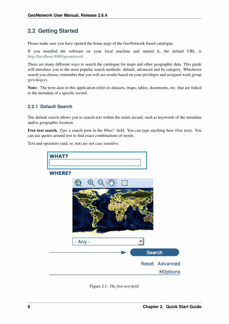
Free text search. Type a search term in the What? field. You can type anything here (free text). Youcan use quotes around text to find exact combinations of words.
Text and operators (and, or, not) are not case sensitive.
Figure 2.1: The free text field.
8 Chapter 2. Quick Start Guide

GeoNetwork User Manual, Release 2.6.4
Geographic search. For the geographic search, two options are available for selecting a particularregion to limit the search:
You can select a region from a predefined list;
Figure 2.2: The region field
You can select your own area of interest in a more interactive way. A small global map is shown on thescreen from which you can drag and drop the frame of your location area. Just click on the button on theupper right of the map screen.
Perform search. Both types of search, free text search and geographic search can be combined torestrict the query further.
Click the Search button to proceed and show the results.
2.2.2 Searching by Categories
An additional way to search data within the GeoNetwork database, from the home page, is searching byCategory. A list of categories is provided to the user to identify data at a more generic level: Applica-tions, Audio/Video, Case study and best practises, Conference proceedings, Datasets, Directories,Interactive resources, Maps and graphics, Other information resources, Photo.
To search only for maps, click on Maps and Graphics. A list of maps will be displayed from whichyou may view details of every single map; just clicking on the Metadata button of the map you wish toreview.
2.2. Getting Started 9
GeoNetwork User Manual, Release 2.6.4
Figure 2.3: Interactive Area Of Interest map
Figure 2.4: The Search button
10 Chapter 2. Quick Start Guide

GeoNetwork User Manual, Release 2.6.4
Figure 2.5: Search by Category
2.2.3 Advanced Search
The advanced search option works similarly to the default search. However, you can be more specificin your search criteria as it offers different elements to look for data, each of them focusing one of thefollowing aspects: What?, Where?, When?
To perform an advanced search, from the home page click Advanced just below the search bottom.
In the WHAT? section the elements are all related to the data content. Through them, in addition tosearching only free keywords in the entire metadata content, you can also search directly in the title orabstract fields and add more keywords to customise your search further. You can also specify the levelof accuracy you wish to reach in performing your search.
• To search by Title, Abstract, Free Text, or Keyword(s) type any text into the respective field.You can enter information in one or multiple field(s). If you do not want to search by a given field,simply leave it blank;
• You can choose the accuracy of your search, in terms of spelling words, from Precise = 1 toImprecise = 0.2, through 3 more consecutive steps which are equal to 0.8, 0.6, 0.4.
The WHERE? parameters, which are related to the spatial extent, allow you, as in the default search,either to select your own area of interest or to select a predefined region from the drop-down list. In thissection you can also type the geographic coordinates of a specific location that is not available from theabove list.
• To select your own area of interest, drag and drop the frame of your area on the global map usingthe appropriate tool on the bottom left of the map screen;
• To use free coordinates, type the lat-long geographic references in the appropriate fields aroundthe map screen, without any limitation of decimal figures;
• To use the coordinates of a predefined region, select the region from the drop-down list.
Whatever type of geographic search you decide to perform, in the Spatial search type field, you canchoose from different options: is, overlaps, encloses, is fully outside of. If you use this field, be cautiousas this limits your output data as follows:
2.2. Getting Started 11

GeoNetwork User Manual, Release 2.6.4
Figure 2.6: Advanced search options
12 Chapter 2. Quick Start Guide

GeoNetwork User Manual, Release 2.6.4
Figure 2.7: Show advanced search options
Figure 2.8: “What” section in the Advanced search
2.2. Getting Started 13

GeoNetwork User Manual, Release 2.6.4
Figure 2.9: “Where” section in the Advanced search
• If you choose Spatial search type is “Country”, only maps for the selected country will be dis-played. In other words, a city map within that country will not show in the output results.
• If you choose Spatial search type overlaps “Country”, all maps with the bounding box overlap-ping that country will be displayed in the results, i.e. the neighbouring countries, the continent ofwhich that country is part of and the global maps.
• If you choose Spatial search type encloses “Country” you will get, in the output results, maps ofthat country first and then all maps within its bounding box.
• Similarly, if you choose Spatial search type is fully outside of a selected region, only maps thatfollow that exact criteria will show in the output results.
The WHEN? section gives you the possibility to restrict your search in terms of temporal extent, indi-cating a specific range of time referred to the data creation or publication date.
• To specify a range of time, click on the date selector button next to From – To fields. Make use ofthe symbols > and >> on top of the calendar to select the month and the year first and then click onthe exact day; a complete date will be filled in using the following standard order: YY-MM-DD.
• To clean the time fields, simply click on the white cross on their right; the box Any will beautomatically selected and the search will be performed without any restriction on the time period.
Finally, the advanced search allows you to apply further restrictions on the basis of additional parametersas data source, data categories and data format.
• To limit your queries to only one Catalogue out of those made available by the installation throughthe harvesting process, highlight the catalogue of preference or just keep Any selected to searchall sites.
• To search for data organised by Category, such as Applications, Datasets, etc., simply highlightthe category you wish to search in from the related drop-down list, otherwise we suggest to leave
14 Chapter 2. Quick Start Guide

GeoNetwork User Manual, Release 2.6.4
Figure 2.10: “When” section in the Advanced search
this field in Any Category.
• You can search for Digital or Hard Copy maps. To search in one or the other, simply check thebox next to the one you wish to search. If no box is checked, all content will be searched.
At last, you can customise the number of output results per page in the Hits Per Page field. Simplyhighlight the number of records to be displayed or leave the field set on the default number (10).
• Click the Search button.
Figure 2.11: Other options in the Advanced search
2.2.4 Search Results
The output of a search provides you a list of the metadata records that should fit your request. For eachrecord, the result page shows the title, an abstract and the keywords. According to the privileges thathave been set for each metadata, a maximum of four sections can be consulted, as shown below.
1. Metadata: The metadata section describes the dataset (e.g.: citation, data owner, tempo-ral/spatial/methodological information) and could contain links to other web sites that could pro-vide further information about the dataset.
2. Download: Depending on the privileges that have been set for each record, when this button ispresent, the dataset is available and downloadable. The process for retrieving data is simple and
2.2. Getting Started 15

GeoNetwork User Manual, Release 2.6.4
Figure 2.12: Search results
16 Chapter 2. Quick Start Guide

GeoNetwork User Manual, Release 2.6.4
quick by just clicking the download button or by using the proper link in the specific metadatasection for distribution info in the full metadata view.
Figure 2.13: A single search result
Figure 2.14: Available services related to the resource
3. Interactive Map: The map service is also optional. When this button is shown, an interactivemap for this layer is available and, by default, it will be displayed on the map screen of the simplesearch. To better visualise the map through the map viewer, click on Show Map on the top ofsearch results panel.
4. Graphic Overviews: There are small and large overviews of the map used to properly evaluateusefulness of the data, especially if the interactive map is not available. Simply click on the smallimage to enlarge it.
2.2.5 Privileges, roles and user groups
GeoNetwork uses a system of Privileges, Roles and User groups.
There are no restrictions for users to search and access public information in a GeoNetwork opensourcebased catalogue. To get access to restricted information or advanced functionality, an account to login is required. This should be provided by the GeoNetwork administrator.
To log in, simply go to the home page and enter your username and password in the dedicated fields onthe top right corner, then click the login button.
2.2. Getting Started 17

GeoNetwork User Manual, Release 2.6.4
Figure 2.15: The interactive map viewer
18 Chapter 2. Quick Start Guide

GeoNetwork User Manual, Release 2.6.4
Figure 2.16: Large preview image
Figure 2.17: Login
2.2. Getting Started 19

GeoNetwork User Manual, Release 2.6.4
Privileges. Depending on the privileges set on a metadata record and on your role as an authenticateduser, you will be able to read about a resource and download or interactively browse data related to thatresource.
Roles. Users with an Editor role can create, import and edit metadata records. They can also uploaddata and configure links to interactive map services.
User groups. Every authenticated user is assigned to a particular work group and is able to view datawithin that work group.
2.3 Viewing and Analysing the Data
Once you have completed your search, you view details of a particular record by clicking on the Meta-data button.
The metadata profiles used by GeoNetwork opensource to present and describe geographic data andgeneral documents stored in the catalogue are based on the International Standard ISO 19115:2003,encoded according to the implementation schema 19139:2007, the FGDC and the international standardDublin Core.
In this guide the ISO 19139 metadata implementation will be described in details since it is also sug-gested as profile for the creation of new metadata records.
2.3.1 Metadata Description
The metadata ISO 19139 profile used by GeoNetwork opensource to describe the geographic data andservices is based on the ISO standard 19115:2003 and provides information related to the identification,the maintenance and constraints, the spatial and temporal extent, the spatial representation and reference,the quality and distribution of a geographic dataset.
The metadata profile is organised in sections and the most important, illustrated in main_sections, arethe: Identification Section, Distribution Section, Reference System Section, Data Quality Section andMetadata Section. These sections are described here in details.
Identification Section
This section includes information on the citation of the resource (title, date of creation or publication,edition, presentation form), the abstract, the purpose and the present*status* of the resource that can bedefined among the options: completed, historical archive, obsolete, ongoing, planned, required or underdevelopment.
This section also contains information about the person or organisation responsible for the data and whois considered to be a point of contact for the resource i.e. the dataset owner, originator, distributor, pub-lisher, etc. and it provides information on data maintenance i.e. annually, monthly, daily, not planned,as needed, etc.
Elements for keywords and for describing restrictions on data access and use are also included in thissection in addition to spatial representation info like data type (vector, raster, text table, etc.)
The identification section provides information about the scale, the language and character set usedwithin the resource and the list of ISO categories through which your map could be classified.
20 Chapter 2. Quick Start Guide

GeoNetwork User Manual, Release 2.6.4
Figure 2.18: Main metadata sections
2.3. Viewing and Analysing the Data 21

GeoNetwork User Manual, Release 2.6.4
Figure 2.19: Identification information
22 Chapter 2. Quick Start Guide

GeoNetwork User Manual, Release 2.6.4
Figure 2.20: Point of Contact
2.3. Viewing and Analysing the Data 23

GeoNetwork User Manual, Release 2.6.4
Figure 2.21: Descriptive keywords
Figure 2.22: Scale and other data properties
24 Chapter 2. Quick Start Guide

GeoNetwork User Manual, Release 2.6.4
Finally, the temporal and spatial extent are also defined in this section. The temporal extent is definedthrough the starting and ending date of data validation.
Figure 2.23: Temporal extent
The spatial extent of the interested area is defined through geographic coordinates or through the selec-tion of a country or region from a predefined list. Free text supplemental information can be added tocomplete the data identification section.
Figure 2.24: Geographic bounding box
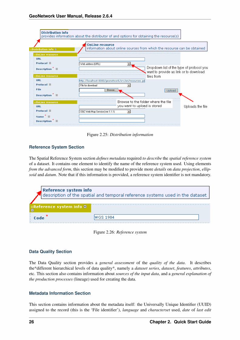
Distribution Section
This section provides metadata elements for accessing other useful on-line resources available throughthe web. The distribution elements allow for on-line access using an URL address or similar addressingscheme and provide the protocol for the proper connection for accessing geographic data or any othertypes of digital documents using the download function. Furthermore, it is possible to link a metadatawith a predefined map service through the online resource and see the map interactively.
2.3. Viewing and Analysing the Data 25
GeoNetwork User Manual, Release 2.6.4
Figure 2.25: Distribution information
Reference System Section
The Spatial Reference System section defines metadata required to describe the spatial reference systemof a dataset. It contains one element to identify the name of the reference system used. Using elementsfrom the advanced form, this section may be modified to provide more details on data projection, ellip-soid and datum. Note that if this information is provided, a reference system identifier is not mandatory.
Figure 2.26: Reference system
Data Quality Section
The Data Quality section provides a general assessment of the quality of the data. It describesthe*different hierarchical levels of data quality*, namely a dataset series, dataset, features, attributes,etc. This section also contains information about sources of the input data, and a general explanation ofthe production processes (lineage) used for creating the data.
Metadata Information Section
This section contains information about the metadata itself: the Universally Unique Identifier (UUID)assigned to the record (this is the ‘File identifier’), language and characterset used, date of last edit
26 Chapter 2. Quick Start Guide

GeoNetwork User Manual, Release 2.6.4
Figure 2.27: Data quality
(‘Date stamp’) and the metadata standard and version name of the record. It also contains informationon the metadata author responsible for the metadata record; this person can also be a point of contactfor the resource described. Information on the Metadata author is mandatory.
2.4 Adding new Data and Information
This section guides you through the process of adding new records (new data with information) intothe GeoNetwork catalogue using either the online metadata editor or the advanced metadata insert tool,based on XML documents. In both cases you will use the template system, add thumbnails, upload data,link to services and set access privileges to the metadata and data.
To add or edit data and metadata, you must be registered as an Editor into the work group you want toadd records to. Contact your administrator if you are not a registered editor for your work group.
For the metadata creation using the online editor, GNos provides a set of simplified metadata templatesbased on the cited standards: ISO, FGDC and DC. The templates for vector and raster based on the ISO19139 are the preferred ones since they are devised in a way that hides the complexity of the ISO19115standard in the default view. At the same time those templates are extensible with new elements to fitspecialized needs through the advanced view.
To produce a good metadata record, always try to gather as much details as possible on the resource thatyou want to describe taking into account the metadata elements that have been presented in the previouschapter. The next step is to fill out properly the fields provided by the metadata templates, while at thesame time avoiding duplication of information throughout the form.
The most important fields that may not be waived while compiling a standard based metadata recordare the following: Title, Date of Creation o Publication, Abstract, Language used for documentingdata, Topic Category, Scale, Maintenance and Update Frequency, Metadata Author, LanguageUsed for Documenting Metadata.
In addition to the main mandatory fields, we recommend you to fill out these optional but critical fields (ifinformation is available): Purpose - Keywords - Presentation Form - Status - Spatial RepresentationType - Geographic Location - Reference System Info - Temporal Extent - Data Quality Info -Access and Use Constraints - Point of Contact - Distribution Info: Online Resources.
You should also prepare an image of your data that is required to be displayed in search results asthumbnail.
2.4. Adding new Data and Information 27

GeoNetwork User Manual, Release 2.6.4
Figure 2.28: Metadata properties
28 Chapter 2. Quick Start Guide

GeoNetwork User Manual, Release 2.6.4
Next section will guide you through the process of metadata creation using the online editor.
2.4.1 Creating a New Record using the web based Metadata Editor
1. In the home page, click on the Administration Tab.
2. Select New Metadata from the List of the admin page.
3. Select the metadata standard Template, if possible, using the preferred ones. GeoNetwork open-source comes by default with support for three metadata standards, ISO19139, FGDC and Dublincore. For the ISO standard, two templates have been developed; one for vector and one for rasterdata. Both contain a relevant set of elements to describe the respective types of data. More tem-plates can be developed online.
4. Select the Group the metadata will belong to. These are the groups authorized to add metadata toby your administrator.
5. Click on Create.
2.4.2 The steps in more details
1. Enter your username and password and click on the login button. The system will identify youand assign the correct privileges to work with.
Figure 2.29: Login
2. Open the Administration page by clicking the Administration button in the banner and then clickon the New metadata link.
Figure 2.30: Administration panel
2.4. Adding new Data and Information 29

GeoNetwork User Manual, Release 2.6.4
3. From the metadata creation page, select the metadata standard to use from the dropdown list(Figure 4.3, “Template selection”)
Figure 2.31: Template selection
4. After selecting the correct template, you should identify which group of users the metadata willbelong to and finally click on Create.
Figure 2.32: Group selection
5. A new metadata form based on the selected template will be displayed for you to fill out.
2.4.3 Switching Editing Views from Default to Advanced to XML View
Once you create a new record, you can choose between Default, Advanced or XML View. To switchview, simply click on the view you want to switch to on the left column of the page. The view in bold isthe view you are currently using.
Figure 2.33: Metadata view options
30 Chapter 2. Quick Start Guide

GeoNetwork User Manual, Release 2.6.4
In the previous chapter you have analyzed the metadata structure as it is presented in the Default View.A selection of the main fields from different categories of information is shown in one single view.The minimum set of metadata required to serve the full range of metadata applications (data discovery,determination of data fitness for use, data access, data transfer and use of digital data) is defined here,along with optional metadata elements to allow for a more extensive standard description of geographicdata, if required. However, if should be there a need to add more metadata elements, you can switch tothe advanced view at any time while editing.
In the Advanced View, the ISO profile offers the possibility to visualize and edit the entire metadatastructure organized in sections accessible through tabs from the left column. You can use this view towrite more advanced metadata descriptions or templates to fit specialized needs.
Figure 2.34: Advanced view
The XML View shows the entire content of the metadata in the original hierarchical structure; differentcolors allow to distinguish between an element’s name and its value. The XML structure is composed oftags and to every tag must correspond a closing tag. The content is entirely contained withing the two,i.e.:
<gmd:language><gco:CharacterString>eng</gco:CharacterString>
</gmd:language>
Nevertheless, the use of the XML view requires some knowledge of the XML language.
Both the Default and the Advanced Views are composed of mandatory, conditional andoptional metadata fields. The meaning of mandatory and optional is fairly intuitive; the manda-tory fields are required, like Title and Abstract for instance, whereas the optional fields can beprovided but are not fundamental, depending on the metadata author. The conditional fields may be con-sidered mandatory under certain circumstances: essentially a conditional requirement indicates that the
2.4. Adding new Data and Information 31

GeoNetwork User Manual, Release 2.6.4
Figure 2.35: XML view
presence of a specified data element is dependent on the value or presence of other data elements in thesame section. For instance, the Individual name metadata element of the Point of Contact,which is a conditional element of the Identification section, becomes mandatory if another element ofthe same section, Organization name or Position name is not already defined.
The mandatory fields as well as those highly recommended are flagged with red asterisk [*]. Thestandard definition for each field can be read by passing the mouse on the element name.
The Default View is the preferred view as it provides a selection of the available metadata elements,facilitating both the user and the editor in reading and editing a metadata record, and at the same time itensures that a geospatial data can be properly described, through :
• the minimum set of metadata required to serve the full range of metadata applications (data dis-covery, determination of data fitness for use, data access, data transfer, and use of digital data);
• optional metadata elements - to allow for a more extensive standard description of geographicdata, if required;
• a method for extending metadata to fit specialized needs.
2.4.4 Using basic commands of the editor
Fields are either free text fields or drop down lists. Free text means you can type any text into thatfield. Drop down lists allow you to select only one option from the list. You can add multiple fields ofthe same kind by clicking on the [+] symbol next to the element. Every new field that you will add inthe advanced view will then be visible in the default view. You can also delete existing fields by clickingon the [x] symbol next to the element. Clearly, mandatory fields cannot be deleted. One example of the
32 Chapter 2. Quick Start Guide

GeoNetwork User Manual, Release 2.6.4
Figure 2.36: Point of Contact
2.4. Adding new Data and Information 33
GeoNetwork User Manual, Release 2.6.4
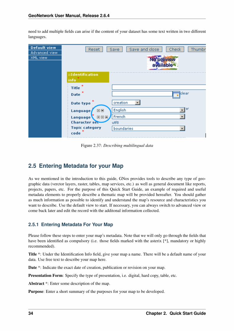
need to add multiple fields can arise if the content of your dataset has some text written in two differentlanguages.
Figure 2.37: Describing multilingual data
2.5 Entering Metadata for your Map
As we mentioned in the introduction to this guide, GNos provides tools to describe any type of geo-graphic data (verctor layers, raster, tables, map services, etc.) as well as general document like reports,projects, papers, etc. For the purpose of this Quick Start Guide, an example of required and usefulmetadata elements to properly describe a thematic map will be provided hereafter. You should gatheras much information as possible to identify and understand the map’s resource and characteristics youwant to describe. Use the default view to start. If necessary, you can always switch to advanced view orcome back later and edit the record with the additonal information collected.
2.5.1 Entering Metadata For Your Map
Please follow these steps to enter your map’s metadata. Note that we will only go through the fields thathave been identified as compulsory (i.e. those fields marked with the asterix [*], mandatory or highlyrecommended).
Title *: Under the Identification Info field, give your map a name. There will be a default name of yourdata. Use free text to describe your map here.
Date *: Indicate the exact date of creation, publication or revision on your map.
Presentation Form: Specify the type of presentation, i.e. digital, hard copy, table, etc.
Abstract *: Enter some description of the map.
Purpose: Enter a short summary of the purposes for your map to be developed.
34 Chapter 2. Quick Start Guide

GeoNetwork User Manual, Release 2.6.4
Status: Specify the status of your map within the following options: completed, historical archive,obsolete, ongoing, planned, required, under development.
Point of Contact: Enter all mandatory information and others you have at hand for the contact ofthe person(s) associated with this resources of the map. Note that some fields are only conditionallymandatory, such as Organization Name if Individual Name and Position are not entered.
Maintenance and update frequency * : Specify the frequency with which you expect to make changesand additions to your map after the initial version is completed. If any changes are scheduled you canleave As Needed selected from the drop-down list.
Descriptive Keywords: Enter keywords that describe your map. Also specify the type of keyword youare entering, i.e. place, theme, etc. Remember that you can add another keyword field if you need to adddifferent types of keywords.
Access Constraints: Enter an access constraint here, such as a copyright, trademark, etc. to assure theprotection of privacy and intellectual property.
User Constraints: Enter a user constraint here to assure the protection of privacy and intellectual prop-erty.
Other Constraints * : Enter other constraint here to assure the protection of privacy and intellectualproperty. Note that this field is conditionally mandatory if Access and Use constraints are not entered.
Spatial representation type: Select, from the drop-down list the method used to spatially representyour data. The options are: vector, grid, text table, stereo model, video.
Scale Denominator * : Enter the denominator for an equivalent scale of a hard copy of the map.
Language* : Select the language used within your map
Topic category * : Specify the main ISO category/ies through which your map could be classified (seeAnnex for the complete list of ISO topic categories).
Temporal Extent * : Enter the starting and ending date of the validity period.
Geographic Bounding Box * : Enter the longitude and latitude for the map or select a region from thepredefined drop-down list. Make sure you use degrees for the unit of the geographic coordinates as theyare the basis for the geographic searches.
Supplemental Information: Enter any other descriptive information about your map that can help theuser to better understand its content.
Distribution Info: Enter information about the distributor and about options for obtaining your map.
Online Resource: Enter information about online resources for the map, such as where a user maydownload it, etc. This information should include a link, the link type (protocol) and a description of theresource.
Reference System Info: Enter information about the spatial reference system of your map. The defaultview contains one element to provide the alphanumeric value identifying the reference system used.GNos uses the EPSG codes which are numeric codes associated with coordinate system definitions.For instance, EPSG:4326 is Geographic lat-long WGS84, and EPSG:32611 is “UTM zone 11 North,WGS84”. Using elements from the advanced view, you may add more details on data projection, ellip-soid and datum. Note that if this information is provided, a reference system identifier is not mandatory.
Data Quality: Specify the hierarchal level of the data (dataset series, dataset, features, attributes, etc.)and provide a general explanation on the production processes (lineage) used for creating the data. Thestatement element is mandatory if the hierarchical level element is equal to dataset or series. Detailed
2.5. Entering Metadata for your Map 35

GeoNetwork User Manual, Release 2.6.4
information on completeness, logical consistency and positional, thematic and temporal accuracy can bedirectly added into the advanced form.
Metadata Author * : Provide information about the author of the map, including the person’s name,organization, position, role and any other contact information available.
After completion of this section, you may select the Type of document that you are going to save in thecatalogue. You have three options: Metadata, Template, Sub-template. By default Metadata is set up.
When done, you may click Save or Save and Close to close the editing session.
2.5.2 Metadata validation
In editing mode, editors could validate the current metadata record against standard rules and recom-mendations.
For all standards, a first level of validation is made for XML metadata validation based on XML Schema(XSD). For ISO19139 records, other rules are checked:
• ISO recommendations
• GeoNetwork recommendations
• (Optional and not available by default) INSPIRE recommendations
The validation report display the list of rules checked and their status (pass or failed). The top checkboxallows to display only errors or all.
2.5.3 Creating a Thumbnail
Next, you need to create a graphic overview of your map which will be for a double purpose; as smallthumbnail will be displayed in search results and as large thumbnail with much more details, to allowusers to properly evaluate the data usefulness. As for the latest, the image that you will use as sourceshould be a significant reproduction of the real dataset, possibly inclusive of the legend.
To create a thumbnail, go to the editing menu for your map. If you are no longer in editing mode, retrievethe map from one of the search options then click on Edit. Then follow these simple steps:
From the editing menu, click on the Thumbnails button on the top or bottom of the page.
• You will be taken to the Thumbnail Management wizard.
• To create a small or large thumbnail, click on the Browse button next to either one. It is recom-mended that you use 180 pixels for small thumbnails and 800x600 for large thumbnails. Usingthe ‘Large thumbnail’ option allows you to create both a small and large thumbnail in one go.
• You can use GIF, PNG and JPEG images as input for the thumbnails.
• A pop up window will appear allowing you to browse your files on your computer. Select the fileyou wish to create a thumbnail with by double-clicking on it.
• Click on Add.
• Your thumbnail will be added and displayed on the following page.
• You can then click on Back to Editing and save your record.
36 Chapter 2. Quick Start Guide

GeoNetwork User Manual, Release 2.6.4
Figure 2.38: The thumbnail wizard button
2.5. Entering Metadata for your Map 37

GeoNetwork User Manual, Release 2.6.4
Figure 2.39: Thumbnail wizard
38 Chapter 2. Quick Start Guide

GeoNetwork User Manual, Release 2.6.4
Figure 2.40: Completed thumbnail wizard
2.5. Entering Metadata for your Map 39

GeoNetwork User Manual, Release 2.6.4
2.5.4 Linking WMS online resources
Metadata records in ISO19139 could be related to resources defined in WMS services. When searchingmetadata that has related WMS online resources, the Interactive Map button is displayed to load theWMS layer/s in the map viewer. A WMS online resource can be referenced in metadata like:
• Selecting protocol OCG-WMS Web Map Capabilities 1.1.1 or OCG-WMS Web Map Capa-bilities 1.3.0:
1. URL: Url of WMS service
2. Name of the resource: empty.
Figure 2.41: WMS online resource
The Interactive Map button opens a window to select the layer/s defined in WMS capabilities documentto load in map viewer.
• Selecting protocols OGC-WMS Web Map Service, OGC Web Map Service 1.1.1 or OGC WebMap Service 1.3.0:
1. URL: Url of WMS service
2. Name of the resource: WMS layer name (optional)
The behaviour the Interactive Map button depends if user indicated the layer name in the field Nameof the resource or not, to show the window to select the layer/s to load in map viewer or load the layerdirectly.
2.5.5 Linking data for download
Finally, you can upload the dataset stored on your local computer and then create a link between dataand related description. Files in whatever format can be uploaded: doc, PDF, images, vector layers,etc. For the latter the distribution in a compressed file is recommended. You can include the verctordata, the legend, any documentation that can help the interpretation of the data, related reports, detaileddescriptions of the data processing, base data used to create the dataset specified and/or other relevantinformation. Follow these guidelines for uploading datasets:
• Make sure the total size of the compressed file is reasonable (less than 50 MB). Should your databe bigger than 50MB, consider a different mechanism to serve this data, e.g. through an FTP orHTTP server and than link the resource through an online resource ‘Web address (URL)’.
• You can create several smaller files when appropriate and upload them sequentially.
• You add the size of the file at the end of the description field.
To Upload a Dataset, follow these steps:
40 Chapter 2. Quick Start Guide

GeoNetwork User Manual, Release 2.6.4
Figure 2.42: Window to select WMS layer/s referenced in online resource to load in map viewer
Figure 2.43: WMS online resource
2.5. Entering Metadata for your Map 41

GeoNetwork User Manual, Release 2.6.4
1. The URL field can be left empty when uploading a file. The system will automatically fill thisfield out;
2. Select the correct protocol to be used. If you do not see the buttons to browse and upload whenFile for download is selected, save the metadata and return to the upload section. Both buttonsshould appear;
3. Provide a short description of the data;
4. Click the Browse button and navigate to the folder where the file to be released is stored. Considerif you want to upload multiple files as one unique zip file or as multiple separate downloads. It is agood idea to add additional documentation with the datasets that provide the user with informationrelated to the data described. Remind: the size of a single file to upload can’t exceed 50 Mbytes;
5. Click Upload and then Save.
Figure 2.44: An online resource
2.5.6 Linking metadata
Metadata records in ISO19139 could be related together based on ISO elements using for example:
• parent identifier
• operates on element for service metadata
Using GeoNetwork editor, user could define 3 types of relation:
• dataset metadata / service metadata (including a link to the data based on WMS layer name)
• parent / child relation
• feature catalogue (ISO19110) / dataset metadata (ISO19139)
All relations are described in the top right corner of the metadata. The menu allows navigation from onerecord to the other. Only metadata records visible to current user are displayed (ie. a metadata could belinked to another one but not displayed because not published for current user).
Parent / child relation
To create a child record, editors could click on the other actions menu, create child option in the searchresults.
Using this option, parent identifier will be automatically set up when duplicating the record.
Editors could also link an existing metadata record using the parent identifier displayed in the advancedview, metadata section. Clicking on the Add or update parent metadata section on the metadata relation
42 Chapter 2. Quick Start Guide

GeoNetwork User Manual, Release 2.6.4
list will move to this view. Then editors should use the (+) to expand the parent identifier and click onthe field to open the metadata selection panel.
Once the parent selected, it will appear in the metadata relation list on the top right corner of the editor.
If a metadata record has children attached, the editor suggest the children update mechanism whichpropagate changes from a parent to all its children. The following interface define the configuration ofthe propagation:
Metadata on dataset / metadata on service relation
Linking a dataset to a service or a service to a dataset is made using the following panel:
Editor could define a layer name using the combo box (which try to retrieve layers from the WMSGetCapabilities document) or typing the layer name in the text field. This information is required todisplay the layer using the map viewer.
2.5. Entering Metadata for your Map 43

GeoNetwork User Manual, Release 2.6.4
Relation is stored in :
<srv:operatesOn uuidref="" xlink:href=""/>
and (according to ISO CSW profil)
<srv:coupledResource><srv:SV_CoupledResource>
<srv:operationName></srv:operationName><srv:identifier></srv:identifier><gco:ScopedName></gco:ScopedName>
</srv:SV_CoupledResource></srv:coupledResource>
Only relation between records in the same catalogue are handle. Use of XLink attributes are not sup-ported to create relation between datasets and services.
Feature catalogue relation
Feature catalogues are records stored in ISO 19110 standard. Relation between the 2 records are createdusing the link feature catalogue menu.
2.5.7 Compute bounding box from keywords
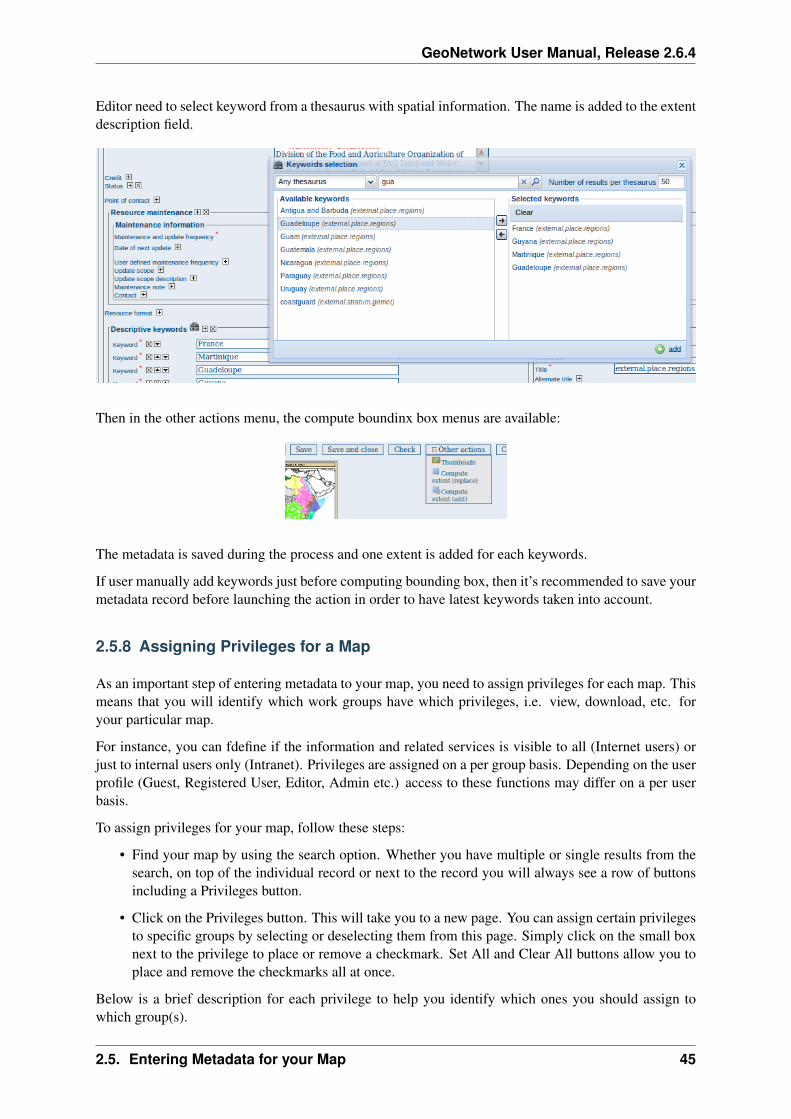
Editor can add extent information based on keyword analysis.
• For each keywords
• Search for the keyword in thesaurus
• If keyword in the thesaurus has an extent
• Add an extent with a description and a bounding box to the metadata record.
The process could be run in 2 modes :
• Add : Keep existing extent elements and add the new one at the end. Editor could clean the sectionafter processing.
• Replace : Remove all extent having only a bounding box (temporal, vertical and bounding polygonare not removed), and add the new one at the end.
44 Chapter 2. Quick Start Guide
GeoNetwork User Manual, Release 2.6.4
Editor need to select keyword from a thesaurus with spatial information. The name is added to the extentdescription field.
Then in the other actions menu, the compute boundinx box menus are available:
The metadata is saved during the process and one extent is added for each keywords.
If user manually add keywords just before computing bounding box, then it’s recommended to save yourmetadata record before launching the action in order to have latest keywords taken into account.
2.5.8 Assigning Privileges for a Map
As an important step of entering metadata to your map, you need to assign privileges for each map. Thismeans that you will identify which work groups have which privileges, i.e. view, download, etc. foryour particular map.
For instance, you can fdefine if the information and related services is visible to all (Internet users) orjust to internal users only (Intranet). Privileges are assigned on a per group basis. Depending on the userprofile (Guest, Registered User, Editor, Admin etc.) access to these functions may differ on a per userbasis.
To assign privileges for your map, follow these steps:
• Find your map by using the search option. Whether you have multiple or single results from thesearch, on top of the individual record or next to the record you will always see a row of buttonsincluding a Privileges button.
• Click on the Privileges button. This will take you to a new page. You can assign certain privilegesto specific groups by selecting or deselecting them from this page. Simply click on the small boxnext to the privilege to place or remove a checkmark. Set All and Clear All buttons allow you toplace and remove the checkmarks all at once.
Below is a brief description for each privilege to help you identify which ones you should assign towhich group(s).
2.5. Entering Metadata for your Map 45

GeoNetwork User Manual, Release 2.6.4
Figure 2.45: The editing toolbar with Privileges button
46 Chapter 2. Quick Start Guide

GeoNetwork User Manual, Release 2.6.4
Figure 2.46: Privileges settings
Publish: Users in the specified group/s are able to see the map, i.e. if searching with matching criteria.
Download: Users in the specified group/s are able to download the map.
Interactive Map: Users in the specified group/s are able to get an interactive map. The interactivemap has to be created separately using a Web Map Server, which is part of the GeoNetwork opensourceapplication.
Featured: When selected, the map is placed in the Features Maps of the home page and it appears thererandomly.
Notify: Users in that work group receive notification that the map has been uploaded.
2.5.9 Assigning Categories for a Map
As a final step to entering metadata for a map, you should assign categories for it. The assigned cate-gories will determine the categories the map will display under on the home page. To assign categoriesfor a map, follow these steps:
• Find your map by using the search option. Whether you have multiple or single results from yoursearch, on top of the individual record or next to the record, you will always see a row of buttonsincluding a Categories button.
• Click on the Categories button. This will take you to a new page. You can assign one or multiplecategories selecting or deselecting them from this page. Simply click on the small box next to thecategory to place or remove a checkmark.
2.5.10 Multilingual metadata in ISO19139
Editors could create multilingual metadata using ISO 19139. A default template is provided but usercould add translation to an existing record.
2.5. Entering Metadata for your Map 47

GeoNetwork User Manual, Release 2.6.4
Figure 2.47: Category management
48 Chapter 2. Quick Start Guide

GeoNetwork User Manual, Release 2.6.4
To declare a new language in a metadata record:
• First check, the main language is defined in the metadata section
• then add one or more languages in the other language in the metadata section.
In editing mode, each multilingual elements are composed of:
• text input
• language selection list (language declared on the other language section are listed here)
By default, the selected language is the GUI language if language is defined in the metadata.
Optionnaly, Google translation service could be used. Translation could be suggested to the editor usingthe small icon right to the language selector. The translation convert the default metadata character stringin the current selected language.
In view mode, according to GUI language : if GUI language is available in the metadata, the element isdisplayed in this language else the element is displayed in metadata default language. This behaviour isalso applied to dublin core output for CSW services.
2.6 Uploading a New Record using the XML Metadata Insert Tool
A more advanced procedure to upload a new metadata record in the GeoNetwork system is using anXML document. This procedure is particularly useful for users who already have metadata in XMLformat, for instance created by some GIS application. To this regard, it has to be noted that the metadatamust be in one of the standards used by GeoNetwork: ISO19115, FGDC and Dublin Core.
To start the metadata uploading process through the XML Metadata Insert tool, you should log in andselect the appropriate option from the Administration page.
The main part of the page Import XML Formatted Metadata that is displayed is the Metadata textarea, where the user can paste the XML metadata to import. Below this, there is the Type choice, whichallows you select the type of record that you are going to create (Metadata, Template and Subtem-plate). Then you can apply a stylesheet to convert your metadata input from ArcCatalog8 to ISO1915or from ISO19115 to ISO19139, if required. Otherwise you can just leave none selected. The Destina-tion schema list provides you with four options to choose the final standard layout for your metadata(ISO19115, ISO19139, FGDC and Dublin Core). Finally you should select the Group as main groupin charge of the metadata and the Category that you want to assign to your metadata. By clicking theInsert button the metadata is imported into the system; please note that all links to external files, forinstance to thumbnails or data for download, have to be removed from the metadata input, to avoid anyconflict within the data repository.
If your metadata is already in ISO19115 format, the main actions to be performed are the following:
1. Paste the XML file that contains the metadata information in the Metadata text area;
2. Select Metadata as type of record that you are going to create
2.6. Uploading a New Record using the XML Metadata Insert Tool 49

GeoNetwork User Manual, Release 2.6.4
Figure 2.48: Administration panel
3. Select the metadata schema ISO19139 that will be the final destination schema;
4. Select the validate check box if you want your metadata to be validated according to the relatedschema.
5. Select the group in charge of the metadata from the drop down list;
6. Select Maps and Graphics from the list of categories;
7. Click the Insert button and the metadata will be imported into the system.
2.7 Metadata in Spatial Data Management
2.7.1 What is Metadata?
Metadata, commonly defined as “data about data” or “information about data”, is a structured set of in-formation which describes data (including both digital and non-digital datasets) stored in administrativesystems. Metadata may provide a short summary about the content, purpose, quality, location of the dataas well as information related to its creation.
2.7.2 What are Metadata Standards?
Metadata standards provide data producers with the format and content for properly describing theirdata, allowing users to evaluate the usefulness of the data in addressing their specific needs.
The standards provide a documented, common set of terms and definitions that are presented in a struc-tured format.
50 Chapter 2. Quick Start Guide

GeoNetwork User Manual, Release 2.6.4
Figure 2.49: XML metadata import tool
2.7. Metadata in Spatial Data Management 51

GeoNetwork User Manual, Release 2.6.4
Figure 2.50: XML metadata import 2
52 Chapter 2. Quick Start Guide

GeoNetwork User Manual, Release 2.6.4
2.7.3 Why do we need Standardised Metadata?
Standardised metadata support users in effectively and efficiently accessing data by using a common setof terminology and metadata elements that allow for a quick means of data discovery and retrieval frommetadata clearinghouses. The metadata based on standards ensure information consistency and qualityand avoid that important parts of data knowledge are lost.
2.7.4 Geographic Information Metadata Standard
Geographic data, which can be defined as any data with a geographic component, is often producedby one individual or organisation, and may address the needs of various users, including informationsystem analysts, programme planners, developers of geographic information or policy makers. Properstandard documentation on geographic data enable different users to better evaluate the appropriatenessof data to be used for data production, storage, update.
The metadata standards supported by GeoNetwork opensource are the ISO 19115:2003 - approved bythe international community in April 2003 as a tool to define metadata in the field of geographic infor-mation - and the FGDC - the metadata standard adopted in the United States by the Federal GeographicData Committee. In addition, GeoNetwork opensource supports also the international standard DublinCore for the description of general documents.
This ISO Standard precisely defines how geographic information and related services should be de-scribed, providing mandatory and conditional metadata sections, metadata entities and metadata ele-ments. This standard applies to data series, independent datasets, individual geographic features andfeature properties. Despite ISO 19115:2003 was designed for digital data, its principles can be extendedto many other forms of geographic data such as maps, charts, and textual documents as well as non-geographic data.
The underlying format of an ISO19115:2003 compliant metadata is XML. GeoNetwork uses the ISOTechnical Specification 19139 Geographic information - Metadata - XML schema implementation forthe encoding of this XML.
2.7.5 Metadata profiles
GeoNetwork supports multiple metadata profiles. Profiles can take the form of Templates that you cancreate using the metadata editor. Using the Advanced view of the editor, virtually all of the metadataelements are accessible to the user.
Support for extensions to a metadata standard can also be achieved relatively quick by an experiencedXML/XSL software engineer.
2.7.6 Transition between metadata standards
With the ISO19115:2003 Metadata standard for Geographic Information now being the preferred com-mon standard, many have a need to migrate legacy metadata into the new standard.
GeoNetwork provides import (and export) functionality and has a number of transformers in place. It isan easy process for a system administrator to install custom transformers based on XSLT.
2.7. Metadata in Spatial Data Management 53

GeoNetwork User Manual, Release 2.6.4
2.8 Installing the software
2.8.1 New version - New funtionality
The new GeoNetwork opensource comes with substantial upgrades of different components for a moreintuitive and responsive user-system interaction. Web2 technologies have been adopted, in particularAJAX techniques, to allow for more interactive and faster services in the web interface and for the inte-gration of the existing web map viewer in the home page. Similar functionalities have been implementedin the administrative part of the system, to provide an easier access to the configuration pages related tosite settings, catalogue harvesting, scheduling and maintenance.
The search interface has been completely overhauled to provide highly interactive searching capabilities.Furthermore, the new version of GNos embeds GeoServer as map server. Users can now not only overlayOGC web map services available on the web, but also create their own map services for other users tobrowse without having to download additional plugins. Maps created with web map services can be nowsaved as PDF and sent to others.
The metadata catalogue handles the latest ISO19115:2003 geographic metadata format based on theISO19139:2007 schemas, as well as the older ISO19115 final draft format, FGDC and Dublin Core. Themetadata editor is able to handle the majority of these complex standards, providing default, advancedand XML editing online tools.
The new version has a number of different harvesting interfaces allowing users to connect their ownserver to many other catalogues around the world. This is the result of the implementation of the opensource reference for the web catalog services according to OGC specifications. Harvesting in the newversion is fully compatible with GeoNetwork 2.0 and higher nodes.
We have added avanced online and offline administration funcionalities to configure, backup and mi-grate the application. We have also added a convenient import and export format “MEF” or MetadataExchange Format, that allows the users to move metadata, previews and even data in a convenient sin-gle file. GNos can be easily expanded with plugins to export/import metadata to/from other softwaresupporting MEF.
2.8.2 Where do I get the installer?
You can find the software on the Internet at the GeoNetwork opensource Commu-nity website. The software is also distributed through the SourceForge.net Website athttp://sourceforge.net/projects/geonetwork.
Use the platform independent installer (.jar) if you need anything more than a plain Windows installation.
2.8.3 System requirements
GeoNetwork can run either on MS Windows , Linux or Mac OS X .
Some general system requirements for the software to run without problems are listed below:
Processor : 1 GHz or higher
Memory (RAM) : 512 MB or higher
Disk Space : 30 MB minimum. However, it is suggested to have a minimum of 250 MB of free diskspace. Additional space is required depending on the amount of spatial data that you expect to uploadinto the internal geodatabse.
54 Chapter 2. Quick Start Guide

GeoNetwork User Manual, Release 2.6.4
Figure 2.51: Standard home page of GeoNetwork opensource
Other Software requirements : A Java Runtime Environment (JRE 1.5.0). For server installations,Apache Tomcat and a dedicated JDBC compliant DBMS (MySQL, Postgresql, Oracle) can be usedinstead of Jetty and McKoiDB respectively.
Additional Software
The software listed here is not required to run GeoNetwork, but can be used for custom installations.
1. MySQL DBMS v5.5+ (All) 1
2. Postgresql DBMS v7+ (All) 1
3. Apache Tomcat v5.5+ (All) 1
4. Druid v3.8 (All) 1 to inspect the database
Supported browsers
GeoNetwork should work normally with the following browsers:
1. Firefox v1.5+ (All) 1
2. Internet Explorer v6+ (Windows)
3. Safari v3+ (Mac OS X Leopard)1 All = Windows, Linux and Mac OS X
2.8. Installing the software 55

GeoNetwork User Manual, Release 2.6.4
2.8.4 How do I install GeoNetwork opensource?
Before running the GeoNetwork installer, make sure that all system requirements are satisfied, and inparticular that the Java Runtime Environment version 1.5.0 is set up on your machine.
On Windows
If you use Windows, the following steps will guide you to complete the installation (other FOSS willfollow):
1. Double click on geonetwork-install-2.2.0.exe to start the GeoNetwork opensource desktop in-staller
2. Follow the instructions on screen. You can choose to install sample data, install the embeddedmap server (based on GeoServer and the CSW 2.0.1 test client. Developers may be interestedin installing the source code and installer building tools. Full source code can be found in theGeoNetwork SubVersion code repository.
3. After completion of the installation process, a ‘GeoNetwork desktop’ menu will be added to yourWindows Start menu under ‘Programs’
4. Click Start>Programs>GeoNetwork desktop>Start server to start the Geonetwork opensourceWeb server. The first time you do this, the system will require about 1 minute to complete startup.
5. Click Start>Programs>Geonetwork desktop>Open GeoNetwork opensource to start usingGeoNetwork opensource, or connect your Web browser to http://localhost:8080/geonetwork/
Installation using the platform independent installer
If you downloaded the platform independent installer (a .jar file), you can in most cases start the installerby simply double clicking on it.
Follow the instructions on screen (see also the section called On Windows).
At the end of the installation process you can choose to save the installation script (Figure Save theinstallation script for commandline installations).
Commandline installation
If you downloaded the platform independent installer (a .jar file), you can perform commandline in-stallations on computers without a graphical interface. You first need to generate an install script (seeFigure Save the installation script for commandline installations). This install script can be edited in atext editor to change some installation parameters.
To run the installation from the commandline, issue the following command in a terminal window andhit enter to start:
java -jar geonetwork-install-2.2.0-0.jar install.xml[ Starting automated installation ][ Starting to unpack ][ Processing package: Core (1/3) ][ Processing package: Sample metadata (2/3) ][ Processing package: GeoServer web map server (3/3) ][ Unpacking finished ]
56 Chapter 2. Quick Start Guide

GeoNetwork User Manual, Release 2.6.4
Figure 2.52: Installer
Figure 2.53: Packages to be installed
2.8. Installing the software 57

GeoNetwork User Manual, Release 2.6.4
Figure 2.54: Save the installation script for commandline installations
58 Chapter 2. Quick Start Guide

GeoNetwork User Manual, Release 2.6.4
[ Writing the uninstaller data ... ][ Automated installation done ]
You can also run the installation with lots of debug output. To do so run the installer with the flag-DTRACE=true:
java -DTRACE=true -jar geonetwork-install-2.6.0-0.jar
2.8.5 XSLT processor configuration
The file INSTALL_DIR/web/geonetwork/WEB-INF/classes/META-INF/javax.xml.transform.TransformerFactorydefines the XSL processor to use in GeoNetwork. The allowed values are:
1. de.fzi.dbs.xml.transform.CachingTransformerFactory for XSL caching (rec-ommended value for production use). When caching is on, only the main XSL stylesheet lastupdate date is checked and not all included XSL. If you update an included stylesheet, cache isstill used.
2. net.sf.saxon.TransformerFactoryImpl to use Saxon
GeoNetwork sets the XSLT processor configuration on the JVM system properties at startup time foran instant to obtain its TransformerFactory implementation, then resets it to original value, to minimizeaffect the XSL processor configuration for other applications.
2.8. Installing the software 59

GeoNetwork User Manual, Release 2.6.4
60 Chapter 2. Quick Start Guide

CHAPTER 3
Administration
3.1 Basic configuration
3.1.1 System configuration
Most of the GeoNetwork system configuration parameters can be changed using the web interface.Those parameters that cannot be changed through the web interface can usually be changed using theGAST application.
Important: Configuration of these parameters is critically important for a proper functioning of theGeoNetwork catalogue in an operational context. Failing to properly change these settings may result ina system that does not function as expected. For example, downloads may fail to be correctly processed,or metadata harvesting from other servers may not work.
To get to the System configuration, you must be logged on as administrator first. Open the Administra-tion page and select System configuration (The link is surrounded with a red rectangle).
Important: New installations of GeoNetwork use admin for both username and password. It is impor-tant to change this from the Administration page once you logged on!
Clicking the page’s link you will get the set of parameters that you can change. Here follows a detaileddescription of them:
At the bottom of the page there are some buttons with the following purpose:
Back Simply returns to the main administration page. Save Saves the current options. If some optionsare invalid, the system will show a dialogue with the wrong parameter and will focus its text field onthe page. Once the configuration is saved a success dialogue will be shown. Refresh This button simplyrefreshes the displayed options taking the new values from the server. This can be useful if some optionsget changed dynamically (for example by another user).
Public host and port usage
Up to now, the server’s host and port are used in these cases:
1. During an editing session, when adding data links to a metadata. The host and port will be usedto build download links to store inside the metadata.
2. During CSW requests. The GetCapabilities operation returns an XML document with HTTP linksto the CSW services. These links are dynamically built using the host and port values.
61

GeoNetwork User Manual, Release 2.6.4
Figure 3.1: The link to the System configuration page
Site General site parameters
Name The name of the GeoNetwork installation. This name will be used to identify the node in opera-tions like the harvesting.
Organization The organization the node belongs to. Just for informative reasons.
Server Here you have to enter the address of your GeoNetwork’s node. This address is important becauseit will be used to access the node.
Host The node’s address or IP number. If your node is publicly accessible from the Internet, you haveto use the machine’s domain/address. If your node is hidden into your private network and you have afirewall or web server that redirects incoming calls to the node, you have to enter the public address ofthe firewall or web server. A typical configuration is to have an Apache web server on address A that ispublicly accessible and redirects the requests to a Tomcat server on a private address B. In this case youhave to enter A in the host parameter.
Port The node’s port (usually 80 or 8080). If the node is hidden, you have to enter the port on the publicfirewall or web server.
Intranet A common need for an organisation is to discriminate between internal anonymous users (usersthat access the node from within the organisation) and external ones (users from the Internet). Node’sadministrators can specify different privileges for internal and external anonymous users and, in orderto do so, they have to specify the parameters of the internal network.
Network The internal network’s address in IP form.
Netmask The network’s mask.
62 Chapter 3. Administration

GeoNetwork User Manual, Release 2.6.4
Figure 3.2: The configuration options
3.1. Basic configuration 63

GeoNetwork User Manual, Release 2.6.4
Catalogue services (CSW, Z39.50)
OGC CSW configuration
See OGC CSW Server configuration
Z39.50 configuration
Z39.50: GeoNetwork can act as a Z39.50 server, which is an OGC communication protocol to queryand retrieve metadata.
Enable: Check this option to start the Z39.50 submodule. Please, notice that GeoNetwork must berestarted in order to make this change active.
port: This is the port on which GeoNetwork will be listening for incoming Z39.50 requests. Usually,the value of 2100 is a standard one, but to have multiple GeoNetwork nodes on the same machine youhave to change this value in order to avoid port conflicts between the different nodes.
XLink resolver
Enables/disables the XLink resolver. XLink resolver replaces content of the elements with attribute@xlink:href (except for srv:operatesOn element) with the referenced content. The XLink resolver isused for example in Metadata fragments harvester to retrieve the metadata fragments referenced in themetadata and insert in it.
Clickable hyperlinks
Enables/disables hyperlinks in metadata content for urls.
INSPIRE
Enables/disables the INSPIRE search options in advanced search panel.
Proxy configuration
Proxy: In some occasions (like harvesting) GeoNetwork must be able to connect to remote sites and thismay be denied if an organisation uses proxy servers. In this cases, GeoNetwork must be configured touse the proxy server in order to route outgoing requests.
Host: The proxy’s name or address to use (usually an IP address).
Port: The proxy’s port to use.
Username (optional): a username should be provided if the proxy server requires authentication.
Password (optional): a password should be provided if the proxy server requires authentication.
64 Chapter 3. Administration

GeoNetwork User Manual, Release 2.6.4
Figure 3.3: The proxy configuration options
Email & notification
Feedback GeoNetwork can sometimes send email, for example if a metadata is downloaded or if a userprovides feedback using the online form. You have to configure the mail server GeoNetwork should usein order to enable it to send email.
Figure 3.4: The mail server configuration options
Email: This is the email address that will be used to send the email (the From address).
SMTP host: the mail server address to use when sending email.
SMTP port: the mail server SMTP port (usually 25).
Removed metadata
Defines the directory used to store a backup of metadata and data after a delete action. This directory isused as a backup directory to allow system administrators to recover metadata and possibly related dataafter erroneous deletion. By default the removed directory is created under the data folder
Authentication
In this section you define the source against which GeoNetwork will authenticate users and passwords.
By default, users are authenticated against info held in the GeoNetwork database. When the GeoNetworkdatabase is used as the authentication source, the user self-registation function can be enabled.
3.1. Basic configuration 65

GeoNetwork User Manual, Release 2.6.4
Figure 3.5: Authentication configuration options
You may choose to authenticate logins against either the GeoNetwork database tables or LDAP (thelightweight directory access protocol) but not both. The next section describes how to authenticateagainst LDAP.
In addition to either of these options, you may also configure other authentication sources. At present,Shibboleth is the only additional authentication source that can be configured. Shibboleth is typicallyused for national access federations such as the Australian Access Federation. Configuring shibbolethauthentication in GeoNetwork to use such a federation would allow not only users from a local databaseor LDAP directory to use your installation, but any user from such a federation.
LDAP Authentication
The section defines how to connect to an LDAP authentication system.
Figure 3.6: The LDAP configuration options
Typically all users must have their details in the LDAP directory to login to GeoNetwork. However if auser is added to the GeoNetwork database with the Administrator profile then they will be able to login
66 Chapter 3. Administration

GeoNetwork User Manual, Release 2.6.4
without their details being present in the LDAP directory.
Shibboleth Authentication
When using either the GeoNetwork database or LDAP for authentication, you can also configure shib-boleth to allow authentication against access federations.
Figure 3.7: The Shibboleth configuration options
Shibboleth authentication requires interaction with Apache web server. In particular, the apache webserver must be configured to require Shibboleth authentication to access the path entered in the configu-ration. The apache web server configuration will contain the details of the shibboleth server that worksout where a user is located (sometimes called a ‘where are you from’ server).
The remainder of the shibboleth login configuration describes how shibboleth authentication attributesare mapped to GeoNetwork user database fields as once a user is authenticated against shibboleth, theirdetails are copied to the local GeoNetwork database.
3.2 User and Group Administration
GeoNetwork uses the concept of Users, Groups and User Profiles. A User can be part of several Groups.A User also has a User Profile
A User can only have one User Profile associated. The combination of User Profile and Group defineswhat tasks the User can perform on the system or on specific metadata records.
3.2.1 Creating new user Groups
The administrator can create new groups of users. User groups can correspond to logical units within anorganisation. For example groups for Fisheries, Agriculture, Land and Water, Health etcetera.
To create new groups you should be logged on with an account that has administrative privileges. Tolog in, simply go to the home page and enter your username and password in the top right corner fields,then click on the login button.
3.2. User and Group Administration 67

GeoNetwork User Manual, Release 2.6.4
Warning: New installations of GeoNetwork use admin for both username and password. It isimportant to change this from the Administration page once you logged on!
Figure 3.8: Login form
1. Select the Administration button in the menu. On the Administration page, select Group manage-ment.
Figure 3.9: Administration page
2. Select Add a new group. You may want to rename or remove the Sample group;
3. Fill out the details. The email address will be used to send feedback on data downloads when theyoccur for resources that are part of the Group.
4. Click on Save
Warning: The Name should NOT contain spaces! You can use the Localisation functions to providelocalised names for groups.
68 Chapter 3. Administration

GeoNetwork User Manual, Release 2.6.4
Figure 3.10: Group management
Figure 3.11: Group edit form
3.2. User and Group Administration 69

GeoNetwork User Manual, Release 2.6.4
Access privileges can be set per metadata record. You can define privileges on a per Group basis.Privileges that can be set relate to visibility of the Metadata (Publish), data Download, Interactive Mapaccess and display of the record in the Featured section of the home page.
Editing defines the groups for which editors can edit the metadata record.
Notify defines what groups are notified when a file managed by GeoNetwork is downloaded.
Below is an example of the privileges management table related to a dataset.
Figure 3.12: Privilege settings
3.2.2 Creating new Users
To add a new user to the GeoNetwork system you do the following:
1. Select User Management from the Administration link in the toolbar;
2. Click the button Add a new user;
1. Provide the information required for the new user;
1. Assign the correct profile;
2. Assign the user to a group;
3. Click on Save.
3.2.3 User Profiles
Users can have different profiles depending on their role in the GeoNetwork system. A profile defineswhat tasks the user can perform.
70 Chapter 3. Administration

GeoNetwork User Manual, Release 2.6.4
Figure 3.13: User administration form
Figure 3.14: User information form
3.2. User and Group Administration 71

GeoNetwork User Manual, Release 2.6.4
User profiles are hierarchical and based on inheritance. This means that a user with an Editor profile cancreate and modify new metadata records, but can also use all functions a Registered user can use.
Rights associated with the profiles are illustrated in detail in the list below:
1. Administrator Profile
The Administrator has special privileges that give access to all available functions. These include:
• Full rights for creating new groups and new users
• Rights to change users/groups’ profiles
• Full rights for creating/editing/deleting new/old metadata
• Perform system administration and configuration tasks.
2. User Administrator Profile
The User Administrator is the administrator of his/her own group with the following privileges:
• Full rights on creating new users within the own group
• Rights to change users profiles within the own group
• Full rights on creating/editing/ deleting new/old data within the own group
3. Content Reviewer Profile
The content reviewer is the only person allowed to give final clearance on the metadata publicationon the Intranet and/or on the Internet:
• Rights on reviewing metadata content within the own group and authorising its publication
4. Editor Profile
The editor works on metadata with following privileges:
• Full rights on creating/editing/ deleting new/old data within the own group
5. Registered User Profile
The Registered User has more access privileges than non-authenticated Guest users:
• Right to download protected data
3.3 OGC CSW Server configuration
When using Open Geospatial Catalogue Service for the Web (OGC-CSW) service, a client will askfor a description of the service. This description, provided in the form of a GetCapabilities document,describes the main service’s properties.
The CSW server section allows configuration of the following CSW properties:
• Enable: This option allows you to start or stop the CSW services. If this option is disabled, othercatalogues cannot connect to the node using CSW protocol.
• Inserted metadata is public: By default, metadata inserted with CSW Transaction operation is notpublic viewable unless a user with proper rights, sets later the metadata permissions to be publicviewable. If this option is checked all metatada inserted with CSW Transation is public viewableby default.
72 Chapter 3. Administration

GeoNetwork User Manual, Release 2.6.4
3.3. OGC CSW Server configuration 73

GeoNetwork User Manual, Release 2.6.4
• Contact: The main contact who is defined in the GetCapabilities document of the CSW service.This contact is one user of the catalogue.
• Title: The title of your CSW service.
• Abstract: The abstract of your CSW service.
• Fees
• Access constraints
The properties Title, Abstract, Fees and Access constraints can be configured in the languages supportedby GeoNetwork GUI. When the user asks for the Capabilities document the values are returned in thelanguage used in the URL:
• http://SERVER/geonetwork/srv/en/csw?request=GetCapabilities&... ,returns the Capabilities document with english values
• http://SERVER/geonetwork/srv/**fr**/csw?request=GetCapabilities&..., returns the Capabilities document with french values
When INSPIRE is enabled and is provided the language parameter in the Capabilities URL it is used thevalue of this parameter. For example:
• http://SERVER/geonetwork/srv/fr/csw?request=GetCapabilities&...&language=eng, returns the Capabilities document with english values
The service description also contains the main keywords of the catalogue. The list of keywords isgenerated by the catalogue based on metadata content.
3.4 Import facilities
3.4.1 File import
The file import facility allows you to import metadata records in XML format or MEF format orcopy/paste XML metadata to insert. In order to use this facility, you have to be logged in as an edi-tor. After the login step, go to the administration page and select the Metadata insert link.
Clicking the link, you will open the metadata import page. You have to specify a set of parameters tomake the import working. Depending on the insert type you will perform:
XML file import
For both, XML and MEF file import, you could choose actions to be performed at import. Import actionsoptions are: No action on import (nothing done during import process), Overwrite metadata with sameUUID (this option will delete existing metadata with the same UUID, and add the new one), GenerateUUID for inserted metadata (this option will force a new UUID for each metadata inserted).
Stylesheet option: This is a powerful option because allows you to specify a stylesheet for an XSLtransformation. The drop down control is filled with files taken from the web/xsl/conversion/importfolder: all XSL files you put there will be made available. This is a dynamic process so you don’thave to restart GeoNetwork. The purpose of this option is to allow the conversion of a metadata into asuitable format that is supported by GeoNetwork. Validate option: This is a simple validation step thatyou can choose to perform. The metadata is validated against its schema. Group option: You have toselect a group to associate to the imported metadata. Usually the group is the creator of the metadata
74 Chapter 3. Administration
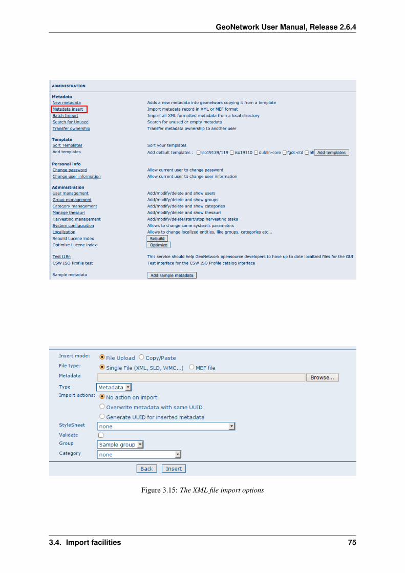
GeoNetwork User Manual, Release 2.6.4
Figure 3.15: The XML file import options
3.4. Import facilities 75

GeoNetwork User Manual, Release 2.6.4
set. Category option: You can specify one category to associate to your metadata in order to simplifythe search.
MEF file import
Figure 3.16: The MEF file import options
As presented before, only actions options could be selected during a MEF import.
XML metadata insert
Choosing the radio button Copy/Paste, you could perform an XML insert, directly copy/pasting yourmetadata record. Please refer to XML import for options you could use.
3.4.2 Batch import
The batch import facility allows you to import a set of metadata into the system all at once. In order to usethis facility, you have to be logged in as an administrator. After the login step, go to the administrationpage and select the batch import’s link.
Clicking the link will open the batch import page. You have to specify a set of parameters to make theimport working. They are:
Directory This is the full path on the server’s file system of the directory to scan. GeoNetwork will lookfor and try to import all XML or MEF files present into this directory. It is important to notice that thisis the directory on the server machine and not on the client of the user that is doing the import. Importactions options are also available from bacth import (please refer to XML import for options you coulduse). Validate This is a simple validation step that you can choose to perform. The metadata is validatedagainst its schema. Group You have to select a group to associate to the imported metadata. Usuallythe group is the creator of the metadata set. Category You can specify one category to associate to yourmetadata in order to simplify the search. Stylesheet This is a powerful option because allows you tospecify a stylesheet for an XSL transformation. The drop down control is filled with files taken from theweb/xsl/conversion/import folder: all XSL files you put there will be made available. This is a dynamicprocess so you don’t have to restart GeoNetwork. The purpose of this option is to allow the conversionof a metadata into a suitable format that is supported by GeoNetwork. Therefore, it is important that theresult of the transformation matches the schema format selected above.
Below the page, there are the following buttons:
Back Goes back to the administration form. Upload Starts the import process. When the process ends,the total count of imported metadata will be shown. Please notice that the import is transactional: the
76 Chapter 3. Administration
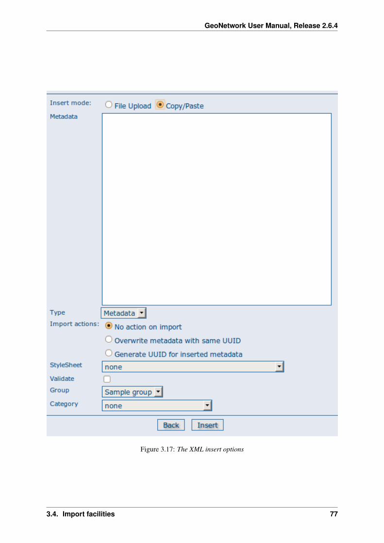
GeoNetwork User Manual, Release 2.6.4
Figure 3.17: The XML insert options
3.4. Import facilities 77

GeoNetwork User Manual, Release 2.6.4
Figure 3.18: How to reach the batch import page
metadata set will be fully imported or fully discarded (there are no partial imports). Files that starts with’.’ or that do not end with ’.xml’ are ignored.
Structured import
An hidden feature of the batch import is the possibility to specify some import parameters in moredetail. This feature is triggered when the specified folder contains the import-config.xml file. When thishappen, this file is read and the standard import switches to the structured one.
The import-config.xml file has a config root element with the following children:
1. categoryMapping [1]: this element specifies the mapping of directories to categories.
(a) mapping [0..n]: This element can appear 0 or more times and maps one directory name to acategory name. It must have a dir attribute that indicates the directory and a to attribute thatindicates the category name.
(b) default [1]: This element specifies a default mapping of categories for all directories that donot match the other mapping elements. It must have only the to attribute.
2. schemaMapping [1]: this element specifies the mapping of directories to metadata schemas.
(a) mapping [0..n]: This element can appear 0 or more times and maps one directory to theschema name that must be used when importing. The provided schema must match theone used by the metadata contained into the specified directory, which must all have thesame schema. It must have a dir attribute that indicates the directory and a to attribute thatindicates the schema name.
78 Chapter 3. Administration
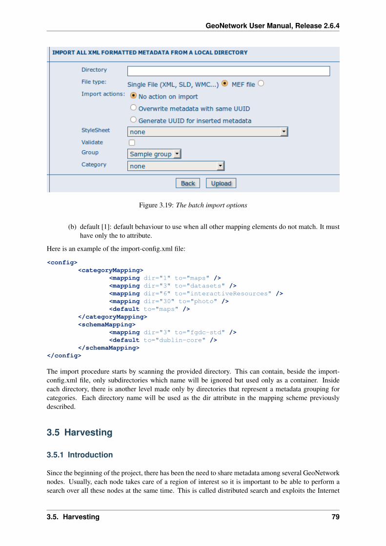
GeoNetwork User Manual, Release 2.6.4
Figure 3.19: The batch import options
(b) default [1]: default behaviour to use when all other mapping elements do not match. It musthave only the to attribute.
Here is an example of the import-config.xml file:
<config><categoryMapping>
<mapping dir="1" to="maps" /><mapping dir="3" to="datasets" /><mapping dir="6" to="interactiveResources" /><mapping dir="30" to="photo" /><default to="maps" />
</categoryMapping><schemaMapping>
<mapping dir="3" to="fgdc-std" /><default to="dublin-core" />
</schemaMapping></config>
The import procedure starts by scanning the provided directory. This can contain, beside the import-config.xml file, only subdirectories which name will be ignored but used only as a container. Insideeach directory, there is another level made only by directories that represent a metadata grouping forcategories. Each directory name will be used as the dir attribute in the mapping scheme previouslydescribed.
3.5 Harvesting
3.5.1 Introduction
Since the beginning of the project, there has been the need to share metadata among several GeoNetworknodes. Usually, each node takes care of a region of interest so it is important to be able to perform asearch over all these nodes at the same time. This is called distributed search and exploits the Internet
3.5. Harvesting 79
GeoNetwork User Manual, Release 2.6.4
connectivity. In our cases, this distributed search can be heavy to perform if there are many maps withassociated thumbnails. Furthermore, GeoNetwork is usually employed in areas (like Africa, Asia) wherethe connectivity can be limited, making the use of distributed search not feasible.
Harvesting is the process of collecting remote metadata and storing them locally for a faster access.This is a periodic process to do, for example, once a week. Harvesting is not a simple import: local andremote metadata are kept aligned. Using some magic, one GeoNetwork node is capable of discoveringmetadata that have been added, removed or updated in the remote node.
GeoNetwork is able to harvest from the following sources (for more details see below):
1. Another GeoNetwork node (version 2.1 or above).
2. An old GeoNetwork 2.0 node.
3. A WebDAV server.
4. A CSW 2.0.1 or 2.0.2 catalogue server.
5. An OAI-PMH server.
6. An OGC service using its GetCapabilities document. These include WMS, WFS, WPS and WCSservices.
7. An ArcSDE server.
3.5.2 Mechanism overview
The harvesting mechanism is based on the concept of a universally unique identifier (UUID). This is aspecial id because it is not only unique locally to the node that generated it but it is unique across all theworld. It is a combination of the network interface’s MAC address, the current date/time and a randomnumber. Every time you create a new metadata in GeoNetwork, a new UUID is generated and assignedto it.
Another important concept behind the harvesting is the last change date. Every time you change ametadata, its last change date is updated. Just storing this parameter and comparing it with a new oneallows any system to find out if the metadata has been modified since last update.
These two concepts allow GeoNetwork to fetch a remote metadata, check if it has been updated andremove it locally if it has been removed remotely. Furthermore, thanks to UUIDs, a hierarchy of har-vesting nodes can be built where B harvests from C and A harvests from B. Even loops can be createdbecause harvested metadata cannot be modified.
3.5.3 Harvesting life cycle
When a harvesting node is set, there is no harvested metadata. During the first run, all remote match-ing metadata are retrieved and stored locally. After the first run, only changed metadata are retrieved.Harvested metadata are not editable for the following reasons:
1. The harvesting is periodic so any local change to harvested metadata will be lost during the nextrun.
2. The change date is used to keep track of changes so if it gets changed outside the originator site,the harvesting mechanism is compromised.
Beside the metadata itself, this implies that users cannot change all other metadata properties (likecategories, privileges etc...).
80 Chapter 3. Administration
GeoNetwork User Manual, Release 2.6.4
The harvesting process goes on until one of the following situations arises:
1. An administrator stops (deactivates) the node.
2. An exception arises. In this case the node is automatically stopped.
When a harvesting node is removed, all harvest metadata are removed too.
3.5.4 Multiple harvesting and hierarchies
Catalogues that provide UUIDs for metadata (for example GeoNetwork and a CSW server) can beharvested several times without having to take care about metadata overlap. This allows the possibilityto perform a thematic search and a metadata belonging to multiple searches is harvested only once andnot duplicated.
This mechanism allows the GeoNetwork harvesting type to be combined with other GeoNetwork nodesto perform hierarchical harvesting. This way a metadata can be harvested from several nodes. Forexample, consider this scenario:
1. Node (A) has created metadata (a)
2. Node (B) harvests (a) from (A)
3. Node (C) harvests (a) from (B)
4. Node (D) harvests from both (A), (B) and (C)
In this scenario, Node (D) will get the same metadata (a) from all 3 nodes (A), (B), (C). The metadatawill flow to (D) following 3 different paths but thanks to its UUID only one copy will be stored. When(a) will be changed in (A), a new version will flow to (D) but, thanks to the change date, the copy in (D)will be updated with the most recent version.
3.5.5 General notes and issues
General
1. The harvesting engine does not store harvesting results. This implies that if the server is restartedthe last results are lost.
2. Changes to the harvesting parameters (for example privileges and categories) are taken into ac-count in the next harvesting run.
GeoNetwork harvesting type
1. During harvesting, site icons are harvested and local copies updated. Icons are propagated to newnodes as soon as these nodes harvest from this one.
2. The metadata UUID is taken from the info.xml file of the MEF bundle. Any UUID stored insidethe metadata will be overwritten with this one.
3.5. Harvesting 81

GeoNetwork User Manual, Release 2.6.4
WebDAV harvesting type
1. The same metadata could be harvested several times by different harvesting nodes. Anyway, thisis not a good practise because every copy of the metadata will have a different UUID and thesystem will fill with different copies of the same metadata.
CSW harvesting type
1. If the dct:modified element is missing from the GetRecords response the metadata will be alwaysharvested.
2. Any exception during getRecordById operation is discarded and the metadata skipped.
OAI-PMH harvesting type
1. The id of the remote server must be a UUID. If not, metadata can be harvested but during hierar-chical propagation id clashes could corrupt harvested metadata.
2. During harvesting, GeoNetwork will try to auto detect the schema of each metadata. If the schemais not supported the metadata is skipped.
OGC service harvesting type
1. Every time the harvester runs, it will remove previously harvested information and create newones. GeoNetwork will generate the id for all metadata (both service and datasets). Therefor, fordatasets, if the metadata is created using a remote XML document (ie. if a MetadataUrl tag is inthe GetCapability document), the UUID of the document is used.
2. Thumbnails are generated only for Web Map Service (WMS). The service should also support theWGS84 projection
3.5.6 The main page
To access the harvesting main page you have to be logged in as an administrator. From the administrationpage, click the link shown below with a red rectangle.
The figure above shows the harvesting main page. The page shows a list of harvesting nodes that havebeen created so far. On the bottom side there is a set of buttons to manage these nodes. The meaning ofeach column is as follows:
1. Select This is just a check box to select one or more nodes. The selected nodes will be affected bythe first row of buttons (start, stop, run, remove). For example, if you select 3 nodes and press theRemove button, these 3 nodes will be removed.
2. Name This is the node’s name provided by the administrator.
3. Type The node’s harvesting type chosen when the node was created (GeoNetwork, web folderetc...).
4. Status This is an icon that reflects the node’s current status. See admin_harvesting_status for alldifferent icons and status description.
82 Chapter 3. Administration
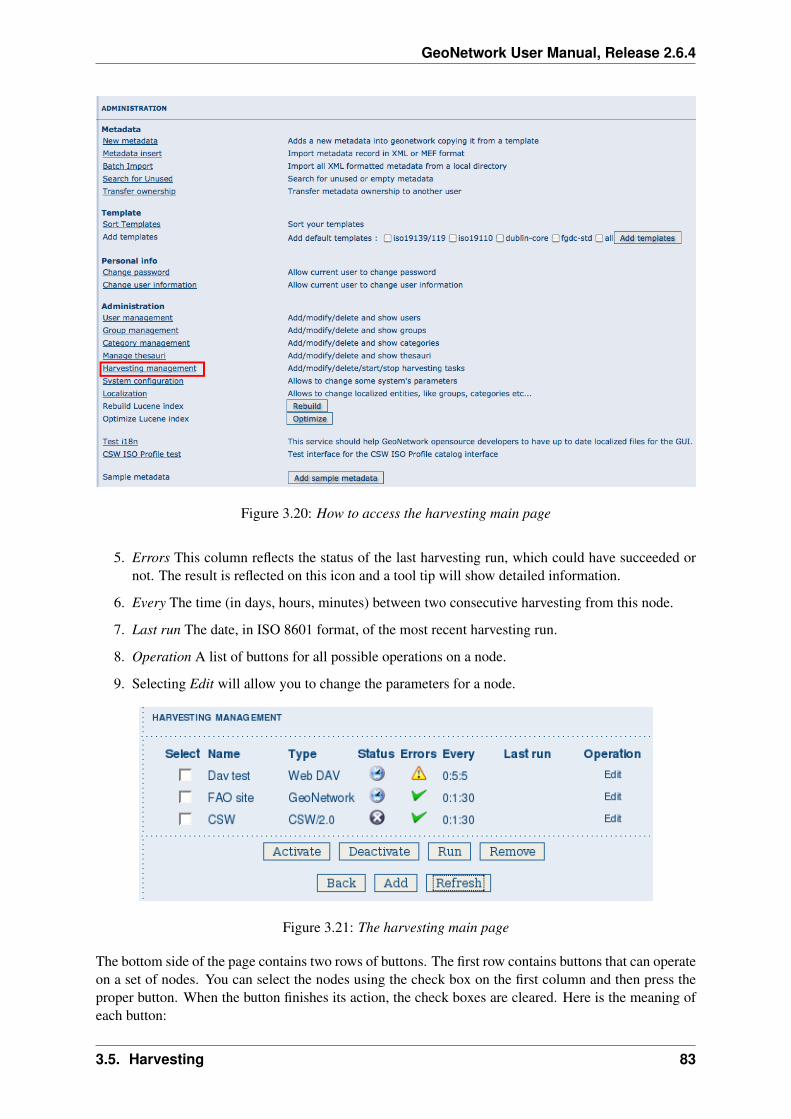
GeoNetwork User Manual, Release 2.6.4
Figure 3.20: How to access the harvesting main page
5. Errors This column reflects the status of the last harvesting run, which could have succeeded ornot. The result is reflected on this icon and a tool tip will show detailed information.
6. Every The time (in days, hours, minutes) between two consecutive harvesting from this node.
7. Last run The date, in ISO 8601 format, of the most recent harvesting run.
8. Operation A list of buttons for all possible operations on a node.
9. Selecting Edit will allow you to change the parameters for a node.
Figure 3.21: The harvesting main page
The bottom side of the page contains two rows of buttons. The first row contains buttons that can operateon a set of nodes. You can select the nodes using the check box on the first column and then press theproper button. When the button finishes its action, the check boxes are cleared. Here is the meaning ofeach button:
3.5. Harvesting 83

GeoNetwork User Manual, Release 2.6.4
1. Activate When a new harvesting node is created, it’s status is inactive. Use this button to make itactive and thus to start harvesting from the remote node.
2. Deactivate Stops harvesting from a node. Please notice that this does not mean that a currentlyrunning harvesting will be stopped but it means that this node will be ignored during future har-vesting.
3. Run This button simply tells the harvesting engine to start harvesting immediately. This is usefulfor testing during the harvesting setup.
4. Remove Remove all currently selected nodes. A dialogue will ask the user to confirm the action.
The second row contains general purpose buttons. Here is the meaning of each button:
1. Back Simply returns to the main administration page.
2. Add This button allows to create new harvesting nodes.
3. Refresh Refreshes the current list of nodes querying the server. This can be useful to see if theharvesting list has been altered by someone else or if any harvesting process started.
Icon Sta-tus
Description
In-ac-tive
The harvesting from this node is stopped.
Ac-tive
The harvesting engine is waiting for the timeout specified for this node. When thetimeout is reached, the harvesting starts.
Run-ning
The harvesting engine is currently running, fetching metadata from remote nodes.When the process will be finished, the status will be switched to active.
Possible status icons
Icon Description
The harvesting was OK, no errors were found. In this case, a tool tip will show someharvesting results (like the number of harvested metadata etc...).
The harvesting was aborted due to an unexpected condition. In this case, a tool tip will showsome information about the error.
Possible error icons
Harvesting result tips
If the harvesting succeeds, a tool tip will show detailed information about the harvesting process. Thisway you can check if the harvester worked as expected or if there is something to fix to the harvestingparameters or somewhere else. The result tip is like a table, where each row refers to
Total This is the total number of metadata found remotely. Metadata with the same id are considered asone. Added Number of metadata added to the system because they were not present locally. RemovedNumber of metadata that have been removed locally because they are not present in the remote serveranymore. Updated Number of metadata that are present locally but that needed to be updated becausetheir last change date was different from the remote one. Unchanged Local metadata left unchanged.Their remote last change date did not change. Unknown schema Number of skipped metadata becausetheir format was not recognised by GeoNetwork. Unretrievable Number of metadata that were readyto be retrieved from the remote server but for some reason there was an exception during the data
84 Chapter 3. Administration

GeoNetwork User Manual, Release 2.6.4
transfer process. Bad Format Number of skipped metadata because they did not have a valid XMLrepresentation. Does not validate Number of metadata which did not validate against their schema.These metadata were harvested with success but skipped due to the validation process. Usually, there isan option to force validation: if you want to harvest these metadata anyway, simply turn it off.
Result vs harvesting type GeoNetwork WebDAV CSW OAI-PMH OGC Service
Total
Added
Removed
Updated
Unchanged
Unknown schema
Unretrievable
Bad Format
Does Not Validate
Thumbnails / Thumbnails failed
Metadata URL attribute used
Result information supported by harvesting types
3.5.7 Adding new nodes
The Add button in the main page allows you to add new harvesting nodes. It will open the form shownin admin_harvesting_add. When creating a new node, you have to choose the harvesting protocol sup-ported by the remote server. The supported protocols are:
1. GeoNetwork 2.1 remote node This is the standard and most powerful harvesting protocol used inGeoNetwork. It is able to log in into the remote node, to perform a standard search usingthe common query fields and to import all matching metadata. Furthermore, the protocolwill try to keep both remote privileges and categories of the harvested metadata if they existlocally. Please notice that since GeoNetwork 2.1 the harvesting protocol has been improved.This means that it is not possible to use this protocol to harvest from version 2.0 or below.
2. WebDAV server This harvesting type uses the webDAV (Distributed Authoring and Versioning)protocol to harvest metadata from a DAV server. It can be useful to users that want topublish their metadata through a web server that offers a DAV interface. The protocol allowsto retrieve the contents of a web page (a list of files) with their change date.
3. Catalogue Services for the Web 2.0 The Open Geospatial Consortium Catalogue Services for theWeb and it is a search interface for catalogues developed by the Open Geospatial Consor-tium. GeoNetwork implements version 2.0 of this protocol.
4. GeoNetwork v2.0 remote node GeoNetwork 2.1 introduced a new powerful harvesting enginewhich is not compatible with GeoNetwork version 2.0 based catalogues. Old 2.0 serverscan still harvest from 2.1 servers but harvesting metadata from a v2.0 server requires thisharvesting type. This harvesting type is deprecated.
5. Z3950 Remote search Not implemented. This is a placeholder.
3.5. Harvesting 85

GeoNetwork User Manual, Release 2.6.4
6. OAI Protocol for Metadata Harvesting 2.0 This is a good harvesting protocol that is widely usedamong libraries. GeoNetwork implements version 2.0 of the protocol.
7. ArcSDE This is a harvesting protocol for metadata stored in an ArcSDE installation.
The drop down list shows all available protocols. Pressing the Add button you will reach an edit pagewhose content depends on the chosen protocol. The Back button will go back to the main page.
Figure 3.22: Adding a new harvesting node
Adding a GeoNetwork node
This type of harvesting allows you to connect to a GeoNetwork node, perform a simple search as in themain page and retrieve all matched metadata. The search is useful because it allows you to focus onlyon metadata of interest. Once you add a node of this type, you will get a page like the one shown below.The meaning of the options is the following:
• Site - Here you put information about the GeoNetwork’s node you want to harvest from (host,port and servlet). If you want to search protected metadata you have to specify an account. Thename parameter is just a short description that will be shown in the main page beside each node.
• Search criteria - In this section you can specify search parameters: they are the same present inthe GeoNetwork homepage. Before doing that, it is important to remember that the GeoNetwork’sharvesting can be hierarchical so a remote node can contain both its metadata and metadata har-vested from other nodes and sources. At the beginning, the Source drop down is empty and youhave to use the Retrieve sources button to fill it. The purpose of this button is to query GeoNet-work about all sources which it is currently harvesting from. Once you get the drop down filled,you can choose a source name to constrain the search to that source only. Leaving the drop downblank, the search will spread over all metadata (harvested and not). You can add several search cri-teria for each site through the Add button: several searches will be performed and results merged.Each search box can be removed pressing the small button on the left of the site’s name. If nosearch criteria is added, a global unconstrained search will be performed.
• Options - This is just a container for general options.
– Every - This is the harvesting period. The smallest value is 1 minute while the greatest valueis 100 days.
– One run only - If this option is checked, the harvesting will do only one run after which itwill become inactive.
• Privileges - Here you decide how to map remote group’s privileges. You can assign a copy policyto each group. The Intranet group is not considered because it does not make sense to copy itsprivileges.
– The All group has different policies from all the others:
1. Copy: Privileges are copied.
86 Chapter 3. Administration

GeoNetwork User Manual, Release 2.6.4
Figure 3.23: Adding a GeoNetwork node
3.5. Harvesting 87

GeoNetwork User Manual, Release 2.6.4
2. Copy to Intranet: Privileges are copied but to the Intranet group. This way publicmetadata can be made protected.
3. Don’t copy: Privileges are not copied and harvested metadata will not be publicly visi-ble.
– For all other groups the policies are these:
1. Copy: Privileges are copied only if there is a local group with the same (not localised)name as the remote group.
2. Create and copy: Privileges are copied. If there is no local group with the same nameas the remote group then it is created.
3. Don’t copy: Privileges are not copied.
Adding a WebDAV node
In this type of harvesting, metadata are retrieved from a remote web page. The available options areshown below and have the following meaning:
• Site - This contains the connection information.
– Name - This is a short description of the node. It will be shown in the harvesting main page.
– URL - The remote URL from which metadata will be harvested. Each file found that endswith .xml will indicate a metadata and will be retrieved, converted into XML and imported.
– Icon - Just an icon to assign to harvested metadata. The icon will be used when showingsearch results.
– Use account - Account credentials for a basic HTTP authentication towards the remote URL.
• Options - General harvesting options.
– Every - This is the harvesting period. The smallest value is 1 minute while the greatest valueis 100 days. One run only If this option is checked, the harvesting will do only one run afterwhich it will become inactive.
– Validate - If checked, the metadata will be validate during import. If the validation does notpass, the metadata will be skipped.
– Recurse - When the harvesting engine will find folders, it will recursively descend into them.
• Privileges - Here it is possible to assign privileges to imported metadata.
– Groups - Groups area lists all available groups in GeoNetwork. Once one (or more) grouphas been selected, it can be added through the Add button (each group can be added onlyonce). For each added group, a row of privileges is created at the bottom of the list to allowprivilege selection.
– Remove - To remove a row simply press the associated Remove button on its right.
• Categories - Here you can assign local categories to harvested metadata.
Adding a CSW node
This type of harvesting is capable of connecting to a remote CSW server and retrieving all matchingmetadata. Please, note that in order to be harvested metadata must have one of the schema format
88 Chapter 3. Administration

GeoNetwork User Manual, Release 2.6.4
Figure 3.24: Adding a WebDAV node
3.5. Harvesting 89

GeoNetwork User Manual, Release 2.6.4
handled by GeoNetwork.
The figure above shows the options available:
• Site - Here you have to specify the connection parameters which are similar to the web DAVharvesting. In this case the URL points to the capabilities document of the CSW server. Thisdocument is used to discover the location of the services to call to query and retrieve metadata.
• Search criteria - Using the Add button, you can add several search criteria. You can query onlythe fields recognised by the CSW protocol.
• Options - General harvesting options:
– Every - This is the harvesting period. The smallest value is 1 minute while the greatest valueis 100 days.
– One run only - If this option is checked, the harvesting will do only one run after which itwill become inactive.
• Privileges - Please, see WebDAV harvesting.
• Categories - Please, see WebDAV harvesting.
Adding an OAI-PMH node
An OAI-PMH server implements a harvesting protocol that GeoNetwork, acting as a client, can use toharvest metadata. If you are requesting the oai_dc output format, GeoNetwork will convert it into itsDublin Core format. Other formats can be harvested only if GeoNetwork supports them and is able toautodetect the schema from the metadata.
Configuration options:
• Site - All options are the same as WebDAV harvesting. The only difference is that the URLparameter here points to an OAI-PMH server. This is the entry point that GeoNetwork will use toissue all PMH commands.
• Search criteria - This part allows you to restrict the harvesting to specific metadata subsets.You can specify several searches: GeoNetwork will execute them sequentially and results willbe merged to avoid the harvesting of the same metadata. Several searches allow you to specifydifferent search criteria. In each search, you can specify the following parameters:
– From - You can provide a start date here. All metadata whose last change date is equal toor greater than this date will be harvested. You cannot simply edit this field but you have touse the icon to popup a calendar and choose the date. This field is optional so if you don’tprovide it the start date constraint is dropped. Use the icon to clear the field.
– Until - Works exactly as the from parameter but adds an end constraint to the last changedate. The until date is included in the date range, the check is: less than or equal to.
– Set - An OAI-PMH server classifies its metadata into hierarchical sets. You can request toreturn metadata that belong to only one set (and its subsets). This narrows the search result.Initially the drop down shows only a blank option that indicate no set. After specifying theconnection URL, you can press the Retrieve Info button, whose purpose is to connect to theremote node, retrieve all supported sets and prefixes and fill the search drop downs. Afteryou have pressed this button, you can select a remote set from the drop down.
– Prefix - Here prefix means metadata format. The oai_dc prefix is mandatory for any OAI-PMH compliant server, so this entry is always present into the prefix drop down. To have
90 Chapter 3. Administration

GeoNetwork User Manual, Release 2.6.4
Figure 3.25: Adding a Catalogue Services for the Web harvesting node
3.5. Harvesting 91

GeoNetwork User Manual, Release 2.6.4
Figure 3.26: Adding an OAI-PMH harvesting node
92 Chapter 3. Administration

GeoNetwork User Manual, Release 2.6.4
this drop down filled with all prefixes supported by the remote server, you have to enter avalid URL and press the Retrieve Info button.
– You can use the Add button to add one more search to the list. A search can be removedclicking the icon on its left.
• Options - Most options are equivalent to WebDAV harvesting.
– Validate - The validate option, when checked, will validate each harvested metadata againstGeoNetwork’s schemas. Only valid metadata will be harvested. Invalid one will be skipped.
• Privileges - Please, see WebDAV harvesting.
• Categories - Please, see WebDAV harvesting.
Please note that when you edit a previously created node, both the set and prefix drop down lists willbe empty. They will contain only the previously selected entries, plus the default ones if they were notselected. Furthermore, the set name will not be localised but the internal code string will be displayed.You have to press the retrieve info button again to connect to the remote server and retrieve the localisedname and all set and prefix information.
Adding an OGC Service (ie. WMS, WFS, WCS)
An OGC service implements a GetCapabilities operation that GeoNetwork, acting as a client, can useto produce metadata. The GetCapability document provides information about the service and the lay-ers/feature types/coverages served. GeoNetwork will convert it into ISO19139/119 format.
Figure 3.27: Adding an OGC service harvesting node
Configuration options:
• Site
– Name - The name of the catalogue and will be one of the search criteria.
– Type - The type of OGC service indicates if the harvester has to query for a specifickind of service. Supported type are WMS (1.0.0 and 1.1.1), WFS (1.0.0 and 1.1.0,WCS (1.0.0) and WPS (0.4.0 and 1.0.0).
3.5. Harvesting 93

GeoNetwork User Manual, Release 2.6.4
– Service URL - The service URL is the URL of the service to contact (withoutparameters like “REQUEST=GetCapabilities”, “VERSION=”, ...). It has to be avalid URL like http://your.preferred.ogcservice/type_wms.
– Metadata language - Required field that will define the language of the metadata.It should be the language used by the web service administrator.
– ISO topic category - Used to populate the metadata. It is recommended to chooseon as the topic is mandatory for the ISO standard if the hierarchical level is“datasets”.
– Type of import - Defines if the harvester should only produce one service metadatarecord or if it should loop over datasets served by the service and produce alsometadata for each datasets. For each dataset the second checkbox allow to generatemetadata for the dataset using an XML document referenced in the MetadataUrlattribute of the dataset in the GetCapability document. If this document is loadedbut it is not valid (ie. unknown schema, bad XML format), the GetCapabilitydocument is used.
For WMS, thumbnails could be created during harvesting. - Icon - The default icondisplayed as attribution logo for metadata created by this harvester.
• Options - Please, see WebDAV harvesting.
• Privileges - Please, see WebDAV harvesting.
• Category for service - Metadata for the harvested service is linked to the category selected forthe service (usually “interactive resources”).
• Category for datasets - For each dataset, the “category for datasets” is linked to each metadatafor datasets.
Adding an ArcSDE server
The ArcSDE harvester allows harvesting metadata from an ArcSDE installation. ArcSDEjava API libraries are required to be installed by the user in GeoNetwork (folderINSTALL_DIR/web/geonetwork/WEB-INF/lib), as these are proprietary libraries notdistributed with GeoNetwork:
• jpe_sdk.jar
• jsde_sdk.jar
Note: dummy-api-XXX.jar must be removed from INSTALL_DIR/web/geonetwork/WEB-INF/lib
The harvester identifies the ESRI metadata format: ESRI ISO, ESRI FGDC to apply the required xsltsto transform metadata to ISO19139
Configuration options:
• Site
– Name - This is a short description of the node. It will be shown in the harvesting main page.
– Server - ArcSde server IP or name
– Port - ArcSde service port (tipically 5151)
– Username - Username to connect to ArcSDE server
94 Chapter 3. Administration
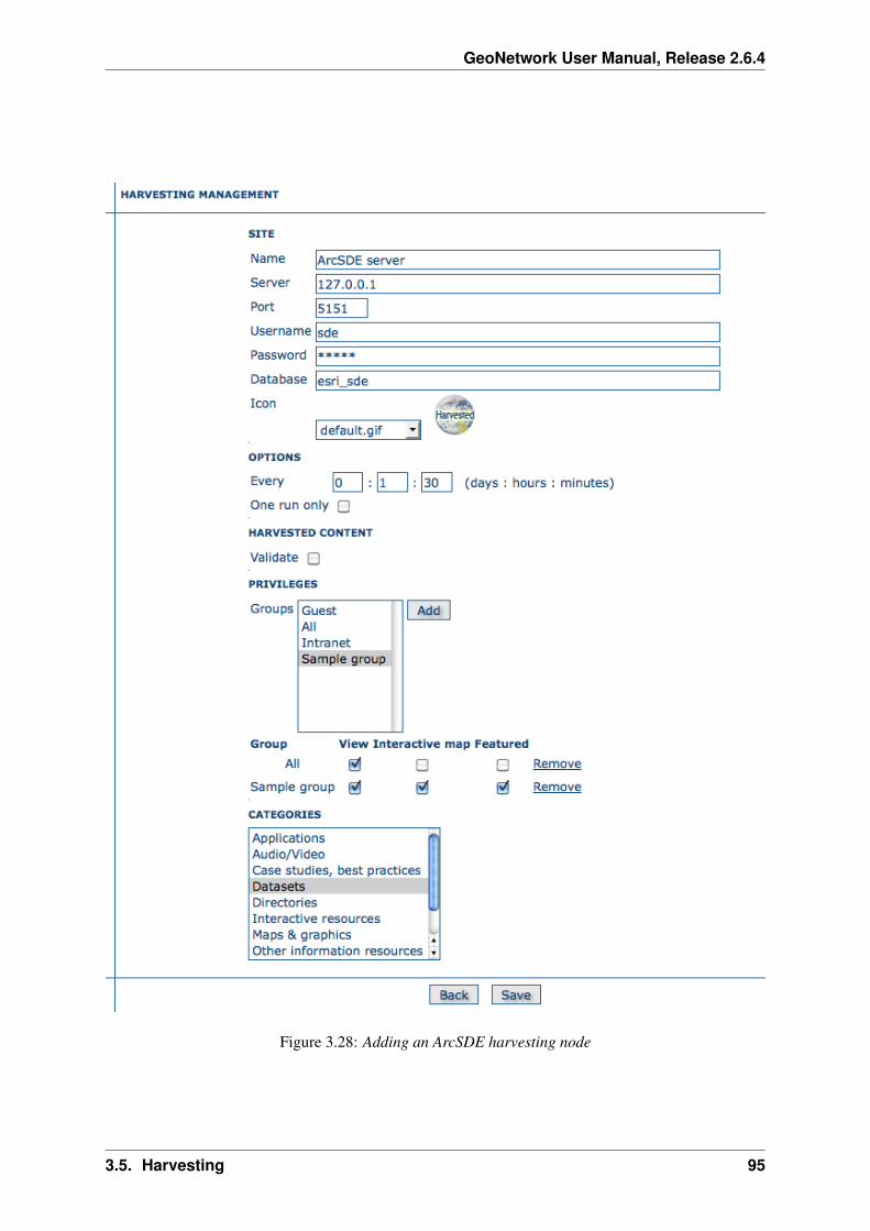
GeoNetwork User Manual, Release 2.6.4
Figure 3.28: Adding an ArcSDE harvesting node
3.5. Harvesting 95

GeoNetwork User Manual, Release 2.6.4
– Password - Password of the ArcSDE user
– Database name - ArcSDE instance name (tipically esri_sde)
• Options - Please, see WebDAV harvesting.
• Privileges - Please, see WebDAV harvesting.
• Category for service - Metadata for the harvested service is linked to the category selected forthe service (usually “interactive resources”).
• Category for datasets - For each dataset, the “category for datasets” is linked to each metadatafor datasets.
3.6 Metadata ownership
3.6.1 Introduction
Starting from release 2.1.0, GeoNetwork has a new metadata access policy. The old edit and adminprivileges have been removed and the concept of reviewer has been introduced. The purpose of this newprofile is to control when a metadata can be published outside or not. In previous releases, all usersbelonging to a group with edit privileges could edit the same metadata. Now, a metadata is only visibleto its creator, to a reviewer which has access to the group owner and to an administrator.
3.6.2 Access policy
A public metadata is a metadata that has the view privilege for the group named all.
Visualisation
An administrator can view any metadata.
A reviewer can view a metadata if:
1. The metadata owner is member of one of the groups assigned to the reviewer.
2. She/he is the metadata owner.
A user administrator or an editor can view:
1. All metadata that has the view privilege selected for one of the groups she/he is member of.
2. All metadata created by her/him.
A registered user can view:
1. All metadata that has the view privilege selected for one of the groups she/he is member of.
Public metadata can be viewed by any user (logged in or not).
Editing
An administrator can edit any metadata.
A reviewer can edit a metadata if:
96 Chapter 3. Administration

GeoNetwork User Manual, Release 2.6.4
1. The metadata owner is member of one of the groups assigned to the reviewer.
2. She/he is the metadata owner.
A User Administrator or an Editor can only edit metadata she/he created.
3.6.3 Privileges
The Privileges administration page is accessible only by:
1. All Administrators
2. All Reviewers that are member of one of the groups assigned to the metadata owner.
3. The Owner of the metadata
Privileges for the All and Intranet groups can only be edited by Administrators and Reviewers.
3.6.4 Transfer Ownership
When metadata ownership needs to be transferred from one user to another for all or specific metadatarecords, the Transfer Ownership option is available. It is located in the Administration page and onceselected, leads to the following page.
Figure 3.29: How to open the Transfer Ownership page
Initially, the page shows only a dropdown for a Source editor (the current metadata owner). The drop-down is filled with all GeoNetwork Users that have the Editor role and own some metadata. Selectingan Editor will select all metadata that is managed by that Editor. An empty dropdown means that thereare no Editors with metadata associated and hence no transfer is possible.
3.6. Metadata ownership 97
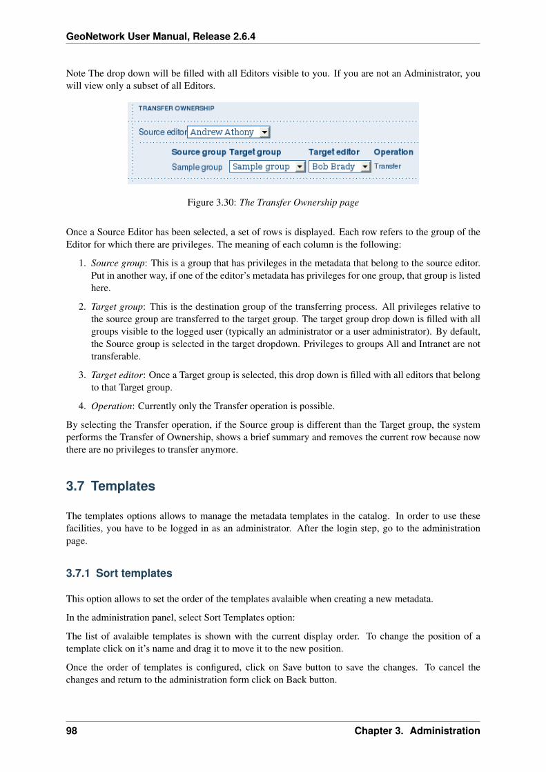
GeoNetwork User Manual, Release 2.6.4
Note The drop down will be filled with all Editors visible to you. If you are not an Administrator, youwill view only a subset of all Editors.
Figure 3.30: The Transfer Ownership page
Once a Source Editor has been selected, a set of rows is displayed. Each row refers to the group of theEditor for which there are privileges. The meaning of each column is the following:
1. Source group: This is a group that has privileges in the metadata that belong to the source editor.Put in another way, if one of the editor’s metadata has privileges for one group, that group is listedhere.
2. Target group: This is the destination group of the transferring process. All privileges relative tothe source group are transferred to the target group. The target group drop down is filled with allgroups visible to the logged user (typically an administrator or a user administrator). By default,the Source group is selected in the target dropdown. Privileges to groups All and Intranet are nottransferable.
3. Target editor: Once a Target group is selected, this drop down is filled with all editors that belongto that Target group.
4. Operation: Currently only the Transfer operation is possible.
By selecting the Transfer operation, if the Source group is different than the Target group, the systemperforms the Transfer of Ownership, shows a brief summary and removes the current row because nowthere are no privileges to transfer anymore.
3.7 Templates
The templates options allows to manage the metadata templates in the catalog. In order to use thesefacilities, you have to be logged in as an administrator. After the login step, go to the administrationpage.
3.7.1 Sort templates
This option allows to set the order of the templates avalaible when creating a new metadata.
In the administration panel, select Sort Templates option:
The list of avalaible templates is shown with the current display order. To change the position of atemplate click on it’s name and drag it to move it to the new position.
Once the order of templates is configured, click on Save button to save the changes. To cancel thechanges and return to the administration form click on Back button.
98 Chapter 3. Administration

GeoNetwork User Manual, Release 2.6.4
3.7. Templates 99

GeoNetwork User Manual, Release 2.6.4
3.7.2 Add templates
This option allows the user to select the metadata templates to add in the catalog to create new metadatarecords.
Mark the metadata templates to import and click Add templates button to import them in the catalog andmake them are avaliable when creating new metadata records.
3.8 Thesaurus
3.8.1 Introduction
Thesaurus support in GeoNetwork allows:
• Metadata editing: controlled vocabulary on the metadata editing interface for ISO and DublinCore
• Administration interface allows import/export/creation/browse thesaurus
• Search interface: a list of keyword is proposed for the keyword criteria
On a node, thesaurus types could be defined as:
• External: When a thesaurus is imported, it is flagged to ”external” which means that users are notallowed to edit the thesaurus. This thesaurus is managed by an external organisation.
• Local: When a thesaurus is created, it is flagged to ”local” which means that users are allowed toedit the thesaurus.
3.8.2 Thesaurus / SKOS format
The Simple Knowledge Organisation Systems (SKOS) http://www.w3.org/2004/02/skos/ is an area ofwork developing specifications and standards to support the use of knowledge organisation systems(KOS) such as thesauri, classification schemes. This format is used by GeoNetwork to store thesaurusinformation.
A concept is defined by an identifier, a preferred label, a definition and links with other concepts. Labelsand definitions could be stored in multiple languages (using the xml:lang attributes). Three type of linksbetween concepts have been defined in the SKOS format:
• related terms
• broader terms
• narrower terms
For example, a concept ”ABLETTE” could be defined as follow with a label in French and English,linked to broader concept:
100 Chapter 3. Administration

GeoNetwork User Manual, Release 2.6.4
<skos:Concept rdf:about="http://www.oieau.org/concept#c4fc54576dc00227b82a709287ac3681"><skos:prefLabel xml:lang="fr">ABLETTE</skos:prefLabel><skos:prefLabel xml:lang="en">BLEAK</skos:prefLabel><skos:broader rdf:resource="http://www.oieau.org/concept#9f25ece36d04776e09492c66627cccb9"/>
</skos:Concept>
GeoNetwork support multilingual thesaurus (e.g. Agrovoc). Search and edition are made based oncurrent user interface language (i.e. if the interface is in English, when editing metadata, GeoNetworkwill only search for concept in English).
3.8.3 Thesaurus administration
To reach the thesaurus administration page you have to be logged in as an administrator. From theadministration page, click the link ”Manage thesauri”. The page shows a list of thesaurus that have beencreated or imported. The upper part of the page allows user to edit/add/modify/consult thesaurus. Thelower part allows upload of thesaurus in SKOS format.
Creation of a new thesaurus
To create a new thesaurus, click the ”+” sign in the category you want your thesaurus to be in. Oncecreated, the thesaurus could be updated through the edit interface. The meaning of each column is asfollows:
• Type - The type allows to classify thesaurus according to its type. First, is defined the type of thethesaurus following ISO category list, then the type indicates if the thesaurus is a local one or anexternal one.
• Name - This is the thesaurus’s name provided by the administrator on creation or filename onupload. When creating a thesaurus, the name of the thesaurus will be the filename of the thesaurus.
Figure 3.31: Administration interface for thesaurus
For each thesaurus the following buttons are available:
• Download - Link to the RFD file.
• Delete - Remove thesaurus from the current node.
3.8. Thesaurus 101
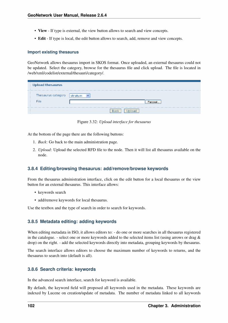
GeoNetwork User Manual, Release 2.6.4
• View - If type is external, the view button allows to search and view concepts.
• Edit - If type is local, the edit button allows to search, add, remove and view concepts.
Import existing thesaurus
GeoNetwork allows thesaurus import in SKOS format. Once uploaded, an external thesaurus could notbe updated. Select the category, browse for the thesaurus file and click upload. The file is located in/web/xml/codelist/external/thesauri/category/.
Figure 3.32: Upload interface for thesaurus
At the bottom of the page there are the following buttons:
1. Back: Go back to the main administration page.
2. Upload: Upload the selected RFD file to the node. Then it will list all thesaurus available on thenode.
3.8.4 Editing/browsing thesaurus: add/remove/browse keywords
From the thesaurus administration interface, click on the edit button for a local thesaurus or the viewbutton for an external thesaurus. This interface allows:
• keywords search
• add/remove keywords for local thesaurus.
Use the textbox and the type of search in order to search for keywords.
3.8.5 Metadata editing: adding keywords
When editing metadata in ISO, it allows editors to: - do one or more searches in all thesaurus registeredin the catalogue. - select one or more keywords added to the selected items list (using arrows or drag &drop) on the right. - add the selected keywords directly into metadata, grouping keywords by thesaurus.
The search interface allows editors to choose the maximum number of keywords to returns, and thethesaurus to search into (default is all).
3.8.6 Search criteria: keywords
In the advanced search interface, search for keyword is available.
By default, the keyword field will proposed all keywords used in the metadata. These keywords areindexed by Lucene on creation/update of metadata. The number of metadata linked to all keywords
102 Chapter 3. Administration

GeoNetwork User Manual, Release 2.6.4
Figure 3.33: Browse interface for thesaurus
Figure 3.34: Keyword description
3.8. Thesaurus 103

GeoNetwork User Manual, Release 2.6.4
Figure 3.35: Keyword selection interface (editing mode)
Figure 3.36: Keyword selection (view mode)
104 Chapter 3. Administration

GeoNetwork User Manual, Release 2.6.4
available in the index are display. User could type in the keyword field or click the icon to get the list ofkeywords available.
Figure 3.37: Thesaurus search interface
Figure 3.38: Auto-complete function in thesaurus search interface
By configuring the config-gui.xml file in the WEB-INF directory, search for keyword using the advancedkeyword selection panel is available as in the metadata editor:
<search><!-- Display or not keyword selection panel in advanced search panel<keyword-selection-panel/>-->
</search>
3.9 GeoNetwork’s Administrator Survival Tool - GAST
3.9.1 What is GAST?
GAST stands for GeoNetwork’s Administrator Survival Tool and is a standalone application whosepurpose is to simplify some low level tasks like change of the servlet, configuration of the JDBC account,setup the database and so on. Most of the GAST’s facilities work only for the GeoNetwork’s installationwhere GAST is in. This implies that if you are using a servlet container other than Jetty (like Tomcat)you will not be able to change some options (like the servlet’s name). Other facilities work for any servletcontainer but you have to specify the GeoNetwork’s URL into the GAST’s configuration dialogue.
3.9.2 Starting GAST
GAST belongs to the core components so it is installed by default.
On Windows computers, simply select the Start GAST option under the GeoNetwork opensource pro-gram group under Start → Programs → GeoNetwork opensource
3.9. GeoNetwork’s Administrator Survival Tool - GAST 105

GeoNetwork User Manual, Release 2.6.4
Other options to start GAST are either to use a Java command from a terminal window or just click itsjar’s icon. To issue the Java command you have to:
1. change directory to the GeoNetwork installation folder
2. issue the command java -jar gast/gast.jar
GAST will be in current system language if any translation is available. If you want to forceGAST GUI language, you could start GAST using the -Duser.language option (e.g. ./gast.sh-Duser.language=fr or java -Duser.language=fr -jar gast/gast.jar).
You can also try to simply open the GeoNetwork installation folder, go to the gast folder and doubleclick on the gast.jar file. If you have Java installed, GAST should start in a few seconds.
To run, GAST requires Java 1.5. It will not work on Java 1.4 and it should run on Java 1.6.
3.9.3 Operating modes
On the left side you have a panel with the tools you can use. After selecting a tool, on the right side youget the tool’s options panel.
Figure 3.39: GAST’s main window with a tool selected
Every function has an operating mode, which defines the condition under which the tool can be used.The tool’s mode is shown with an icon on the right side of the tool’s name. The operating modes, withtheir icons are summarised in the following table:
106 Chapter 3. Administration

GeoNetwork User Manual, Release 2.6.4
Mode Icon Description
Restarted The tool can be always used, but GeoNetwork must be restarted in order to make thechange effective.
Run-ning
The tool can be used only if GeoNetwork is running.
Stopped The tool can be used only if GeoNetwork is stopped. This is important because sometools change the database’s account or create the database from scratch. These aresensitive operations that cannot be performed while GeoNetwork is running.
3.9.4 Tools subdivision
All GAST tools present into the left panel are logically subdivided into groups. Each group represents aGeoNetwork’s aspect for which GAST allows you a graphic interface. The groups are:
Configuration You can change some configuration parameters, like the servlet’s name, JDBC accountetc... Management General purpose tools related to the site’s administration. Database Operations thatregard the database. Here you can find tools to create a database from scratch, creating the schema andfilling it with proper data. Migration Tools that allow you to migrate metadata from old installation.
3.9.5 Server and Account configuration dialogue
Some of the GAST’s tools access a running GeoNetwork application. Usually, GAST connects toGeoNetwork using the connection parameters it finds on the installation folder but you can specifyother parameters in order to connect to other instances. This is required when the GeoNetwork instanceis not running on the embedded Jetty server. In addition to that, some tools require authentication soaccount parameters must be provided.
To provide these parameters, you have to use the GAST ’s configuration dialogue. To open the dialogue,select Options >> Config from the menu bar. You will get the following dialogue:
Figure 3.40: The configuration dialogue
3.9. GeoNetwork’s Administrator Survival Tool - GAST 107
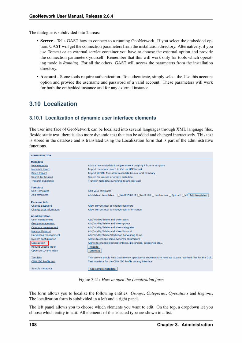
GeoNetwork User Manual, Release 2.6.4
The dialogue is subdivided into 2 areas:
• Server - Tells GAST how to connect to a running GeoNetwork. If you select the embedded op-tion, GAST will get the connection parameters from the installation directory. Alternatively, if youuse Tomcat or an external servlet container you have to choose the external option and providethe connection parameters yourself. Remember that this will work only for tools which operat-ing mode is Running. For all the others, GAST will access the parameters from the installationdirectory.
• Account - Some tools require authentication. To authenticate, simply select the Use this accountoption and provide the username and password of a valid account. These parameters will workfor both the embedded instance and for any external instance.
3.10 Localization
3.10.1 Localization of dynamic user interface elements
The user interface of GeoNetwork can be localized into several languages through XML language files.Beside static text, there is also more dynamic text that can be added and changed interactively. This textis stored in the database and is translated using the Localization form that is part of the administrativefunctions.
Figure 3.41: How to open the Localization form
The form allows you to localize the following entities: Groups, Categories, Operations and Regions.The localization form is subdivided in a left and a right panel.
The left panel allows you to choose which elements you want to edit. On the top, a dropdown let youchoose which entity to edit. All elements of the selected type are shown in a list.
108 Chapter 3. Administration
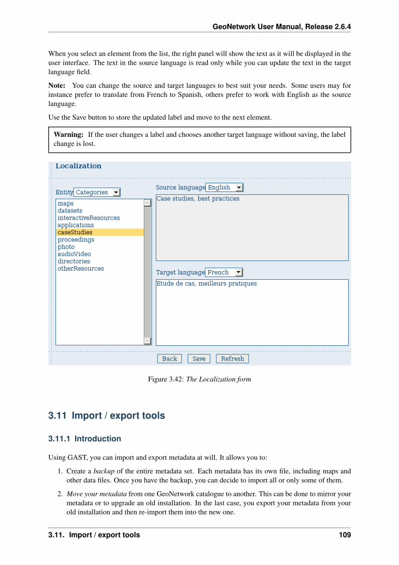
GeoNetwork User Manual, Release 2.6.4
When you select an element from the list, the right panel will show the text as it will be displayed in theuser interface. The text in the source language is read only while you can update the text in the targetlanguage field.
Note: You can change the source and target languages to best suit your needs. Some users may forinstance prefer to translate from French to Spanish, others prefer to work with English as the sourcelanguage.
Use the Save button to store the updated label and move to the next element.
Warning: If the user changes a label and chooses another target language without saving, the labelchange is lost.
Figure 3.42: The Localization form
3.11 Import / export tools
3.11.1 Introduction
Using GAST, you can import and export metadata at will. It allows you to:
1. Create a backup of the entire metadata set. Each metadata has its own file, including maps andother data files. Once you have the backup, you can decide to import all or only some of them.
2. Move your metadata from one GeoNetwork catalogue to another. This can be done to mirror yourmetadata or to upgrade an old installation. In the last case, you export your metadata from yourold installation and then re-import them into the new one.
3.11. Import / export tools 109

GeoNetwork User Manual, Release 2.6.4
3. Fill the system with test data. Using the ’skip UUID’ option, you can re-import the same metadataover and over again. This is useful, for example, if you want to perform stress tests.
Metadata are exported in the MEF format.
Warning: Ownership - Please, consider that the MEF format version 1.0 does not take into accountuser and group ownership. When exporting metadata, you loose this information. When importingmetadata, the new owner becomes the user that is performing the import while the group ownershipis set to null.
3.11.2 Import
This tool is located under Management tools on the left panel and allows you to import a set of metadatathat have been previously exported using the export facility. Selecting the Import tool opens the optionpanel.
Figure 3.43: The metadata import panel
• Input folder - The source folder in your system that GAST will scan to collect metadata to import.GAST will try to import all files with the MEF extension.
• Browse button - Navigate through your file system to choose an output location or enter it man-ually into the text field.
• Import - This will start the process. A progress dialogue will be opened to show the import status.
Note: Sub-folders are not scanned.
3.11.3 Export
This tool is located under the Management tool on the left panel and allows you to export a set ofmetadata using the MEF format. Selecting the Export tool opens the option panel.
• Output folder - The target folder in your file system where GAST will put the exported metadata.You can either select the Browse button to navigate through your file system to choose a betterlocation or enter it manually in the text field.
110 Chapter 3. Administration

GeoNetwork User Manual, Release 2.6.4
Figure 3.44: The metadata export panel
• Format - Here you can specify the metadata’s output format. See the MEF specification for moreinformation.
• Skip UUID - Normally this option is not required. If you select it, you will loose the metadata’sunique identifier (UUID) but you will be able to re-import that metadata over and over again. Thisis useful to fill the system with test data.
• Search - Allows to specify free text search criteria to limit the set of exported records.
• Export - This will start the export process. A progress dialogue will be opened to show the exportstatus.
Note: The result of the export will depend on the access privileges of the user. If you do not authenticate,you will get only public metadata.
Warning: Skipping the UUID on import or export can cause metadata to be duplicated. This shouldnormally always be avoided
3.11. Import / export tools 111

GeoNetwork User Manual, Release 2.6.4
112 Chapter 3. Administration

CHAPTER 4
Glossary of Metadata FieldsDescription
This glossary provides you with brief descriptions of the minimum set of metadata fields required toproperly describe a geographical data as well as some optional elements highly suggested for a moreextensive standard description.
Access constraints Access constraints applied to assure the protection of privacy or intellectual prop-erty, and any special restrictions or limitations on obtaining the resource
Abstract Brief narrative summary of the content of the resource(s)
Administrative area State, province of the location
Temporal extent - Begin date Formatted as 2007-09-12T15:00:00 (YYYY-MM-DDTHH:mm:ss)
Character set Full name of the character coding standard used for the metadata set
Grid spatial representation - Cell geometry Identification of grid data as point or cell
City City of the location
Reference System Info - Code Alphanumeric value identifying an instance in the namespace
Country Country of the physical address
Data quality info Provides overall assessment of quality of a resource(s)
Date Reference date and event used to describe it (YYYY-MM-DD)
Date stamp Date that the metadata was created (YYYY-MM-DDThh:mm:ss)
Date type Event used for reference date
Delivery point Address line for the location (as described in ISO 11180, annex A)
Equivalent scale - Denominator The number below the line in a vulgar fraction
Data Quality - Description Description of the event, including related parameters or tolerances
OnLine resource - Description Detailed text description of what the online resource is/does
Descriptive keywords Provides category keywords, their type, and reference source
Grid spatial representation - Dimension name Name of the axis i.e. row, column
113

GeoNetwork User Manual, Release 2.6.4
Grid spatial representation - Dimension size Number of elements along the axis
Dimension size Resolution Number of elements along the axis
Distribution info Provides information about the distributor of and options for obtaining the resource(s)
Geographic bounding box - East bound longitude Eastern-most coordinate of the limit of the datasetextent, expressed in longitude in decimal degrees (positive east)
Edition Version of the cited resource
Electronic mail address Address of the electronic mailbox of the responsible organisation or individual
Temporal extent - End date Formatted as 2007-09-12T15:00:00 (YYYY-MM-DDTHH:mm:ss)
Equivalent scale Level of detail expressed as the scale of a comparable hardcopy map or chart
Extent Information about spatial, vertical, and temporal extent
Facsimile Telephone number of a facsimile machine for the responsible organisation or individual
File identifier Unique identifier for this metadata file
Vector spatial representation - Geometric object type Name of point and vector spatial objects usedto locate zero-, one-and two-dimensional spatial locations in the dataset
Vector spatial representation - Geometric object count Total number of the point or vector objecttype occurring in the dataset
Geographic bounding box Geographic position of the dataset
Grid spatial representation Information about grid spatial objects in the dataset
Grid spatial representation - Resolution value Degree of detail in the grid dataset
Grid spatial representation - Transformation parameter availability Indication of whether or notparameters for transformation exists
Data Quality - Hierarchy level Hierarchical level of the data specified by the scope
Identification info Basic information about the resource(s) to which the metadata applies
Point of Contact - Individual name Name of the responsible person- surname, given name, title sepa-rated by a delimiter
Keyword Commonly used word(s) or formalised word(s) or phrase(s) used to describe the subject
Data Language Language used for documenting data
Metadata - Language Language used for documenting metadata
Data Quality - Lineage Non-quantitative quality information about the lineage of the data specified bythe scope. Mandatory if report not provided
OnLine resource - Linkage Location (address) for on-line access using a Uniform Resource Locatoraddress or similar addressing scheme such as http://www.statkart.no/isotc211
Maintenance and update frequency Frequency with which changes and additions are made to the re-source after the initial resource is completed
Metadata author Party responsible for the metadata information
Metadata standard name Name of the metadata standard (including profile name) used
Metadata standard version Version (profile) of the metadata standard used
114 Chapter 4. Glossary of Metadata Fields Description

GeoNetwork User Manual, Release 2.6.4
OnLine resource - Name Name of the online resource
Geographic bounding box - North bound latitude Northern-most, coordinate of the limit of thedataset extent expressed in latitude in decimal degrees (positive north)
Grid spatial representation - Number of dimensions Number of independent spatial-temporal axes
Distribution Info - OnLine resource Information about online sources from which the resource can beobtained
Point of Contact - Organisation name Name of the responsible organisation
Other constraints Other restrictions and legal prerequisites for accessing and using the resource
Point of contact Identification of, and means of communication with, person(s) and organisations(s)associated with the resource(s)
Point of contact - Position name Role or position of the responsible person
Postal code ZIP or other postal code
Presentation form Mode in which the resource is represented
OnLine resource - Protocol Connection protocol to be used
Purpose Summary of the intentions with which the resource(s) was developed
Reference system info Description of the spatial and temporal reference systems used in the dataset-Data
Data Quality - Report Quantitative quality information for the data specified by the scope. Mandatoryif lineage not provided
Grid spatial representation - Resolution value Degree of detail in the grid dataset
Point of contact - Role Function performed by the responsible party
Geographic bounding box - South bound latitude Southern-most coordinate of the limit of thedataset extent, expressed in latitude in decimal degrees (positive north)
Spatial representation info Digital representation of spatial information in the dataset
Spatial representation type Method used to spatially represent geographic information
Data Quality - Statement General explanation of the data producer’s knowledge about the lineage ofa dataset
Status Status of the resource(s)
Supplemental Information Any other descriptive information about the dataset
Temporal Extent Time period covered by the content of the dataset
Title Name by which the cited resource is known
Topic category code High-level geographic data thematic classification to assist in the grouping andsearch of available geographic data sets. Can be used to group keywords as well. Listed examplesare not exhaustive. NOTE It is understood there are overlaps between general categories and theuser is encouraged to select the one most appropriate.
Grid spatial representation - Transformation parameter availability Indication of whether or notparameters for transformation exists
115

GeoNetwork User Manual, Release 2.6.4
Vector spatial representation - Topology level Code which identifies the degree of complexity of thespatial relationships
Type Subject matter used to group similar keywords
URL Unified Resource Locator
Use constraints Constraints applied to assure the protection of privacy or intellectual property, and anyspecial restrictions or limitations or warnings on using the resource
Vector spatial representation Information about the vector spatial objects in the dataset
Voice Telephone number by which individuals can speak to the responsible organisation or individual
Geographic bounding box - West bound longitude Western-most coordinate of the limit of thedataset extent, expressed in longitude in decimal degrees (positive east)
116 Chapter 4. Glossary of Metadata Fields Description

CHAPTER 5
ISO Topic Categories
Iso Topic Categories and Keywords
117

GeoNetwork User Manual, Release 2.6.4
118 Chapter 5. ISO Topic Categories

GeoNetwork User Manual, Release 2.6.4
119
GeoNetwork User Manual, Release 2.6.4
120 Chapter 5. ISO Topic Categories

CHAPTER 6
Free and Open Source Software forGeospatial Information Systems
A range of related software packages can be used in addition to GeoNetwork opensource to deploy afull Spatial Data Infrastructure. These include Web Map Server software, GIS desktop applications andWeb Map Viewers.
Below you will find some examples of open source software available for each categories.
6.1 Web Map Server software
• GeoServer (All)
• MapServer (All)
• MapGuide Open Source (Windows & Linux)
• Deegree (All)
6.2 GIS Desktop software
• GRASS (All)
• gvSIG (All)
• uDig (All)
• Quantum GIS (All)
• OSSIM (Windows & OSX)
6.3 Web Map Viewer and Map Server Management
• OpenLayers (All)
• MapBender (All)
121

GeoNetwork User Manual, Release 2.6.4
Note: All = The Windows, Linux and Mac OS X operating systems.
122 Chapter 6. Free and Open Source Software for Geospatial Information Systems

CHAPTER 7
Frequently Asked Questions
This is a list of frequently encountered problems, suggestions that help to find the cause of the problemand possible solutions. The list is by no means exhaustive. Feel free to contribute by submitting newproblems and their solutions to the developer mailinglist.
Note: <install directory> is a placeholder for the GeoNetwork installation directory.
<some file> should be read as some random file name.
Warning: Be very careful when issuing commands on the terminal! You can easily damage youroperating system with no way back. If you are not familiar with using the terminal: don’t do it,contact an expert instead! Make a backup of your data before you make any of the suggestedchanges below!
7.1 HTTP Status 400 Bad request
Check the availability and write permissions of the data and tmp directories.
See The data and data/tmp directories
7.2 Metadata insert fails
Inserting an XML or MEF file through the Metadata insert form fails silently. Verify if the data directoryis available and writable.
See The data and data/tmp directories
7.3 Thumbnail insert fails
Nothing happens when inserting a thumbnail through the wizard in the metadata editor.
Error in your log file looks like:
123
GeoNetwork User Manual, Release 2.6.4
HTTP Status 400 - Cannot build ServiceRequest Cause : <install directory>/data/tmp/<some file> (No such file or directory) Error : java.io.FileNotFoundException
Then check The data and data/tmp directories
7.4 The data and data/tmp directories
On Linux or OS X systems verify from a terminal if the data directory is existing and is writable.
ls -la <install directory>/data
This should show the permissions on the data directory. For example:
total 0drwxr-xr-x 6 tomcat tomcat 204 19 jan 15:34 .drwxr-xr-x 8 tomcat tomcat 272 23 dec 19:30 ..drwxr-xr-x 10 tomcat tomcat 340 19 jan 15:47 00000-00099drwxr-xr-x 21 tomcat tomcat 714 23 dec 19:30 geoserver_datadrwxr-xr-x 3 tomcat tomcat 102 23 dec 19:30 removeddrwxr-xr-x 3 tomcat tomcat 102 19 jan 15:47 tmp
The above example shows that only the user tomcat has write access on the directories listed. All otherusers have read (and execute) rights only. See http://en.wikipedia.org/wiki/Filesystem_permissions formore details on file permissions.
Make sure your web server is running as user tomcat. Check this with the command:
ps aux | grep tomcat
You should see the processes that have tomcat in their description. Something like this:
bash-3.2# ps aux | grep tomcattomcat 22253 0,7 0,0 2435120 532 s000 S+ 5:03pm 0:00.00 grep tomcattomcat 22251 0,0 1,9 2861960 80596 s000 S 5:03pm 0:03.85 /System/Library/Frameworks/JavaVM.framework/Versions/CurrentJDK/Home/bin/java -Djava.util.logging.config.file=/usr/local/apache-tomcat-6.0.32/conf/logging.properties -Djava.util.logging.manager=org.apache.juli.ClassLoaderLogManager -Djava.endorsed.dirs=/usr/local/apache-tomcat-6.0.32/endorsed -classpath /usr/local/apache-tomcat-6.0.32/bin/bootstrap.jar -Dcatalina.base=/usr/local/apache-tomcat-6.0.32 -Dcatalina.home=/usr/local/apache-tomcat-6.0.32 -Djava.io.tmpdir=/usr/local/apache-tomcat-6.0.32/temp org.apache.catalina.startup.Bootstrap start
If all is well, the user referred to at the start of this string (in this case tomcat) is the same user that haswrite permissions on the data and tmp directories.
You now have two possible solutions:
• Make the data and temporary directories writable to all users. You can change this using thecommand:
chmod -R a+w <install directory>/data
Your permissions should now look like this:
drwxrwxrwx 6 tomcat tomcat 204 19 jan 15:34 .etc..
Note: the ‘w’ refers to ‘write’ access
• The second solution is to ensure the user running the webserver is the same user that holds writeaccess to the data directory (in this case tomcat). For this, you can (a) change the user running theprocess, or (b) change ownership of the directory using the chown command:
chown -R tomcat:tomcat <install directory>/data
124 Chapter 7. Frequently Asked Questions

CHAPTER 8
Glossary
ebRIM Enterprise Business Registry Information Model..
CSW Catalog Service for the Web. The OGC Catalog Service defines common interfaces to discover,browse, and query metadata about data, services, and other potential resources.
ISO International Standards Organisation is an international-standard-setting body composed of repre-sentatives from various national standards organizations. http://www.iso.org
ISO TC211 ISO/TC 211 is a standard technical committee formed within ISO, tasked with coveringthe areas of digital geographic information (such as used by geographic information systems) andgeomatics. It is responsible for preparation of a series of International Standards and TechnicalSpecifications numbered in the range starting at 19101.
GeoNetwork GeoNetwork opensource is a standards based, Free and Open Source catalog applicationto manage spatially referenced resources through the web. http://geonetwork-opensource.org
GPL The GNU General Public License is a free, copyleft license for software and other kinds of works.GeoNetwork opensource is released under the GPL 2 license. http://www.gnu.org/licenses/old-licenses/gpl-2.0.html
Creative Commons GeoNetwork documentation is released under the Creative Com-mons Attribution-ShareAlike 3.0 Unported License. Find more information athttp://creativecommons.org/licenses/by-sa/3.0/
XML Extensible Markup Language is a general-purpose specification for creating custom markuplanguages.
XSD XML Schema, published as a W3C recommendation in May 2001, is one of several XML schemalanguages. http://en.wikipedia.org/wiki/XSD
ebXML Enterprise Business XML.
DAO Data Access Object.
CRUD Create Read Update and Delete.
DB (or DBMS) A database management system (DBMS) is computer software that managesdatabases. DBMSes may use any of a variety of database models, such as the network modelor relational model. In large systems, a DBMS allows users and other software to store and re-trieve data in a structured way.
125
GeoNetwork User Manual, Release 2.6.4
SOA Service Oriented Architecture provides methods for systems development and integration wheresystems package functionality as interoperable services. A SOA infrastructure allows differentapplications to exchange data with one another.
FGDC The Federal Geographic Data Committee (FGDC) is an interagency committee that promotesthe coordinated development, use, sharing, and dissemination of geospatial data on a nationalbasis in the USA. See http://www.fgdc.gov
JMS Java Messaging Service.
TDD Test Driven Development.
JIBX Binding XML to Java Code.
HQL Hibernate Query Language.
OO Object Oriented.
EJB Enterprise Java Beans.
SOAP Simple Object Access Protocol is a protocol specification for exchanging structured informationin the implementation of Web Services in computer networks.
OGC Open Geospatial Consortium. A standards organization for geospatial information systemshttp://www.opengeospatial.org
OSGeo The Open Source Geospatial Foundation (OSGeo), is a non-profit non-governmental organi-zation whose mission is to support and promote the collaborative development of open geospatialtechnologies and data. http://www.osgeo.org
FAO Food and Agriculture Organisation of the United Nations is a specialised agency of the UnitedNations that leads international efforts to defeat hunger. http://www.fao.org
WFP World Food Programme of the United Nations is the food aid branch of the United Nations, andthe world’s largest humanitarian organization. http://www.wfp.org
UNEP The UN Environment Programme (UNEP) coordinates United Nations environmental activities,assisting developing countries in implementing environmentally sound policies and encouragessustainable development through sound environmental practices. http://www.unep.org
OCHA United Nations Office for the Coordination of Humanitarian Affairs is designed to strengthenthe UN’s response to complex emergencies and natural disasters. http://ochaonline.un.org/
URL A Uniform Resource Locator specifies where an identified resource is available and the mecha-nism for retrieving it.
GAST GeoNetwork Administrator Survival Tool. A desktop application that allows administrators ofa GeoNetwork catalog to perform a range of admin operations.
WebDAV Web-based Distributed Authoring and Versioning. WebDAV is a set of extensions to theHypertext Transfer Protocol (HTTP) that allows users to edit and manage files collaboratively onremote World Wide Web servers.
OAI-PMH Open Archive Initiative Protocol for Metadata Harvesting. It is a protocol developed by theOpen Archives Initiative. It is used to harvest (or collect) the metadata descriptions of the recordsin an archive so that services can be built using metadata from many archives.
WMS Web Map Service is a standard protocol for serving georeferenced map images over the Inter-net that are generated by a map server using data from a GIS database. The specification wasdeveloped and first published by the Open Geospatial Consortium in 1999.
126 Chapter 8. Glossary

GeoNetwork User Manual, Release 2.6.4
WFS Web Feature Service provides an interface allowing requests for geographical features acrossthe web using platform-independent calls. One can think of geographical features as the “sourcecode” behind a map.
WCS Web Coverage Service provides an interface allowing requests for geographical coverages acrossthe web using platform-independent calls. The coverages are objects (or images) in a geographicalarea
WPS Web Processing Service is designed to standardize the way that GIS calculations are made avail-able to the Internet. WPS can describe any calculation (i.e. process) including all of its inputs andoutputs, and trigger its execution as a Web Service.
UUID A Universally Unique Identifier (UUID) is an identifier standard used in software construc-tion, standardized by the Open Software Foundation (OSF) as part of the Distributed ComputingEnvironment (DCE).
MAC address Media Access Control address (MAC address) is a unique identifier assignedto most network adapters or network interface cards (NICs) by the manufacturer foridentification, and used in the Media Access Control protocol sublayer. See alsohttp://en.wikipedia.org/wiki/MAC_address on Wikipedia
MEF Metadata Exchange Format. An export format developed by the GeoNetwork community. Moredetails can be found in this manual in Chapter Metadata Exchange Format.
SKOS The Simple Knowledge Organisation Systems (SKOS) is an area of work developing specifica-tions and standards to support the use of knowledge organisation systems (KOS) such as thesauri,classification schemes. http://www.w3.org/2004/02/skos/
Z39.50 protocol Z39.50 is a client-server protocol for searching and retrieving information from re-mote computer databases. It is covered by ANSI/NISO standard Z39.50, and ISO standard 23950.The standard’s maintenance agency is the Library of Congress.
SMTP Simple Mail Transfer Protocol is an Internet standard for electronic mail (e-mail) transmissionacross Internet Protocol (IP) networks.
LDAP Lightweight Directory Access Protocol is an application protocol for querying and modifyingdirectory services running over TCP/IP.
Shibboleth The Shibboleth System is a standards based, open source software package for web singlesign-on across or within organisational boundaries. It allows sites to make informed authorisationdecisions for individual access of protected online resources in a privacy-preserving manner.
DC The Dublin Core metadata element set is a standard for cross-domain information resource de-scription. It provides a simple and standardised set of conventions for describing things online inways that make them easier to find.
ESA European Space Agency is an intergovernmental organisation dedicated to the exploration ofspace. http://www.esa.int
FOSS Free and Open Source Software, also F/OSS, FOSS, or FLOSS (free/libre/open source software)is software which is liberally licensed to grant the right of users to study, change, and improve itsdesign through the availability of its source code. http://en.wikipedia.org/wiki/FOSS
JDBC The Java Database Connectivity (JDBC) API is the industry standard for database-independentconnectivity between the Java programming language and a wide range of databases – SQLdatabases and other tabular data sources, such as spreadsheets or flat files. The JDBC API pro-vides a call-level API for SQL-based database access. JDBC technology allows you to use theJava programming language to exploit “Write Once, Run Anywhere” capabilities for applications
127

GeoNetwork User Manual, Release 2.6.4
that require access to enterprise data. With a JDBC technology-enabled driver, you can connectall corporate data even in a heterogeneous environment.
128 Chapter 8. Glossary
Index
CCreative Commons, 125CRUD, 125CSW, 125
DDAO, 125DB (or DBMS), 125DC, 127
EebRIM, 125ebXML, 125EJB, 126ESA, 127
FFAO, 126FGDC, 126FOSS, 127
GGAST, 126GeoNetwork, 125GPL, 125
HHQL, 126
Iimport
MEF, 74XML, 74
ISO, 125ISO TC211, 125
JJDBC, 127
JIBX, 126JMS, 126
LLDAP, 127
MMAC address, 127MEF, 127
import, 74
OOAI-PMH, 126OCHA, 126OGC, 126OO, 126OSGeo, 126
SShibboleth, 127SKOS, 127SMTP, 127SOA, 125SOAP, 126
TTDD, 126
UUNEP, 126URL, 126UUID, 127
WWCS, 127WebDAV, 126WFP, 126WFS, 126
129

GeoNetwork User Manual, Release 2.6.4
WMS, 126WPS, 127
XXML, 125
import, 74XSD, 125
ZZ39.50 protocol, 127
130 Index