georeferencing workshop rebecca j. rowe university of chicago committee on evolutionary biology...
TRANSCRIPT

Georeferencing Workshop
Rebecca J. Rowe
University of Chicago
Committee on Evolutionary Biology
&
Division of Mammals
The Field Museum

Outline
• What is georeferencing?• Introduce the point-radius methodology • Introduce georeferencing tools• Work through some examples

Georeferencing is the expression of a
spatial description in
coordinates within a
frame of reference
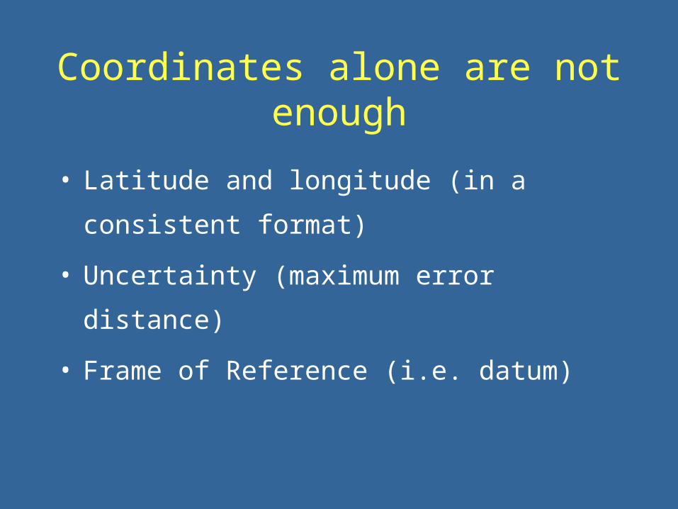
Coordinates alone are not enough
• Latitude and longitude (in a consistent format)
• Uncertainty (maximum error distance)
• Frame of Reference (i.e. datum)

Retrospective Georeferencing
From textual descriptors:• determine coordinates • assign spatial uncertainty
From collector determined coordinates:• convert coordinates (if necessary)• assign spatial uncertainty
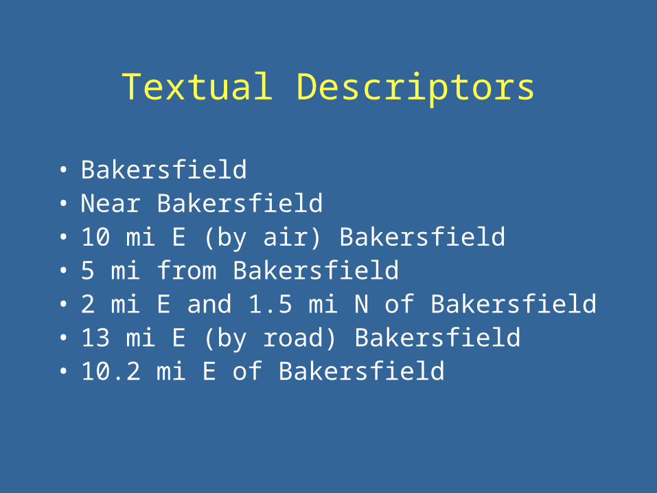
Textual Descriptors
• Bakersfield• Near Bakersfield• 10 mi E (by air) Bakersfield• 5 mi from Bakersfield• 2 mi E and 1.5 mi N of Bakersfield• 13 mi E (by road) Bakersfield• 10.2 mi E of Bakersfield
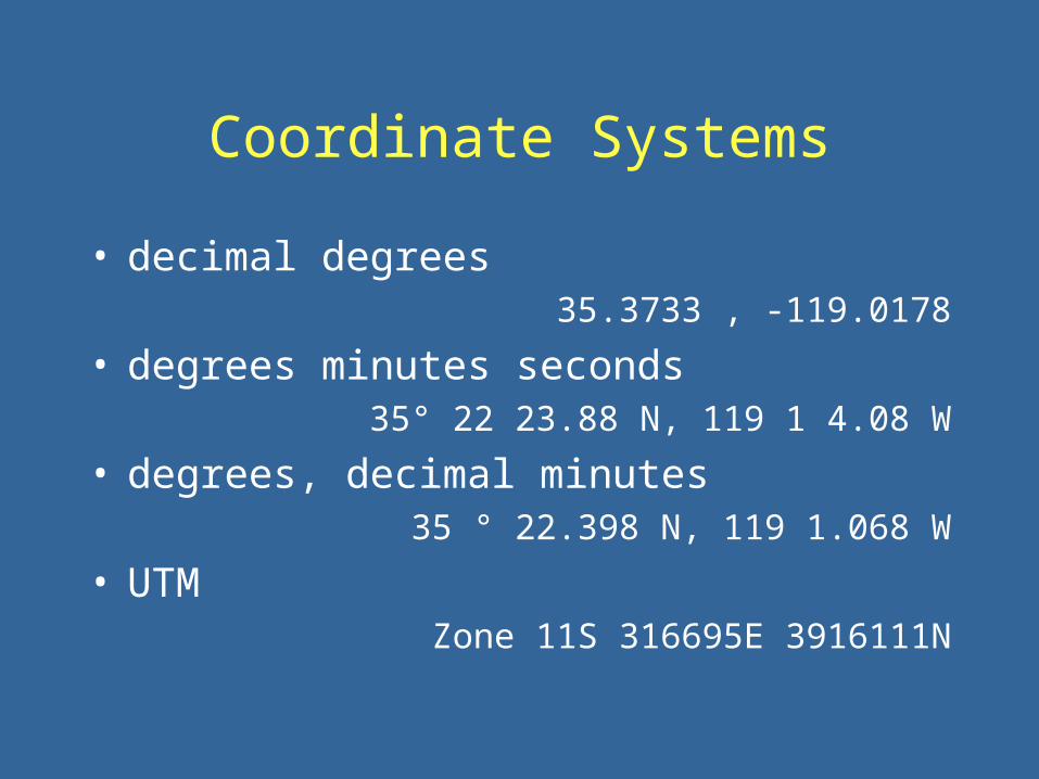
Coordinate Systems
• decimal degrees35.3733 , -119.0178
• degrees minutes seconds35° 22 23.88 N, 119 1 4.08 W
• degrees, decimal minutes 35 ° 22.398 N, 119 1.068 W
• UTM Zone 11S 316695E 3916111N

The Ultimate Goal
• Spatially explicit link between the identity of a voucher, and the collection event
• Increases data for biological distribution & diversity studies
• Enables computer based geographic analyses

The Ultimate Goal
• Spatially explicit link between the identity of a voucher, and the collection event
• Increases body of data for biological distribution and diversity studies
• Enables computer-based geographic analyses

The Ultimate Goal
Spatial Uncertainty
• The geographic area encompassing all possible locations for the point
Georeferencing, the how to
Choosing the right georeferencing method is a
compromise between precision, accuracy, and speed

The Point-Radius Method
• Uses one set of coordinates, the datum, and a bounding radius to describe a locality
• Can incorporate both manual and automated georeferencing methods
• Is a reproducible process
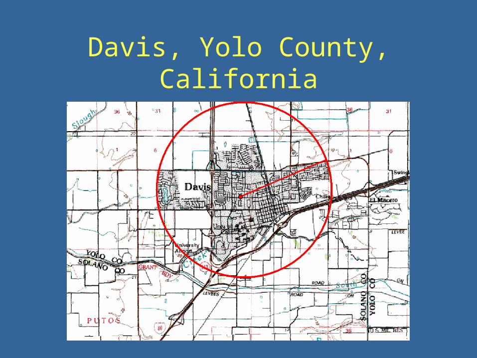
Davis, Yolo County, California

Davis, Yolo County, California
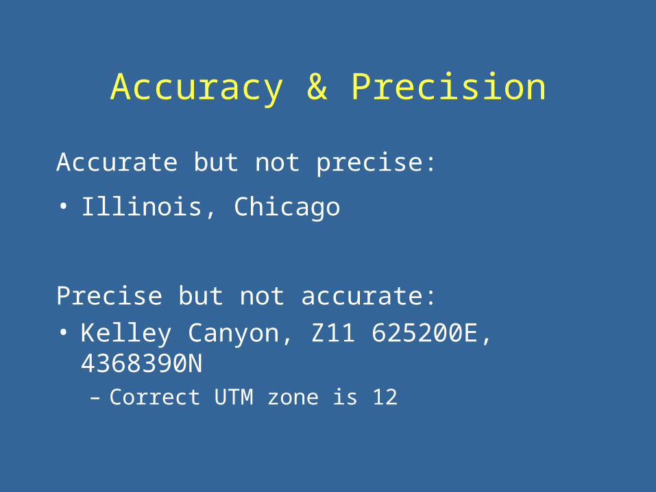
Accuracy & Precision
Accurate but not precise:
• Illinois, Chicago
Precise but not accurate:• Kelley Canyon, Z11 625200E, 4368390N
– Correct UTM zone is 12

Accuracy & Precision
The georeferencing process aims to increase both the accuracy of the locality descriptor
and the locality precision
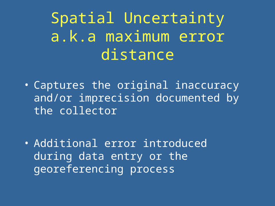
Spatial Uncertaintya.k.a maximum error distance
• Captures the original inaccuracy and/or imprecision documented by the collector
• Additional error introduced during data entry or the georeferencing process
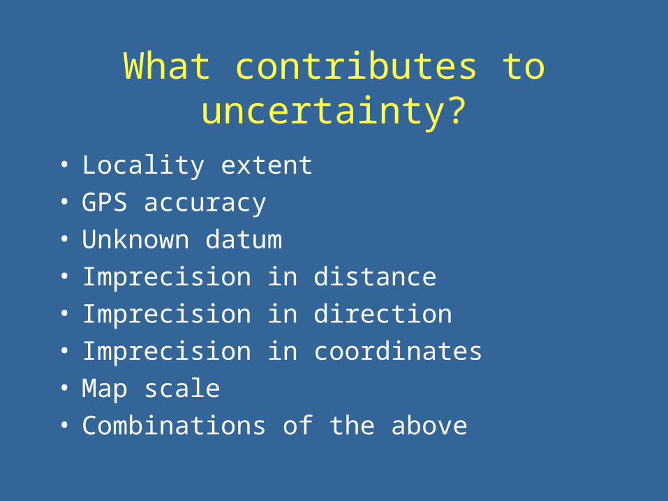
What contributes to uncertainty?
• Locality extent• GPS accuracy• Unknown datum• Imprecision in distance • Imprecision in direction• Imprecision in coordinates• Map scale• Combinations of the above

Out of context,
you can’t assume what the collector meant!

Locality Extent
• Named places are not single points
• Use the geographic center of a place & measure the greatest extent for the uncertainty
• In general, current extents will be greater than historical ones, yielding conservative measures

Davis, Yolo County, California
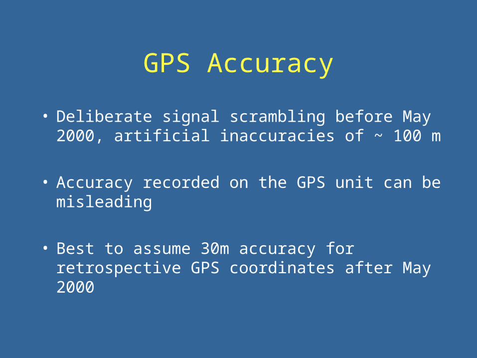
GPS Accuracy
• Deliberate signal scrambling before May 2000, artificial inaccuracies of ~ 100 m
• Accuracy recorded on the GPS unit can be misleading
• Best to assume 30m accuracy for
retrospective GPS coordinates after May 2000

Unknown Datum
• Geodetic datums define the size and shape of the earth and the origin and orientation of the coordinate systems used to map the earth
• Without a datum, coordinates are like measures without units.

Datums
Frames of Reference:• Australian Geodetic 1984• Japanese Geodetic Datum 2000• North American Datum (NAD) 1927• North American Datum (NAD) 1983• South American 1969• World Geodetic System (WGS) 1984
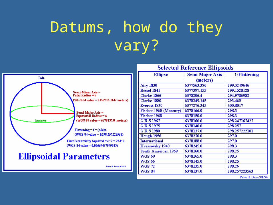
Datums, how do they vary?

Why is the datum important?
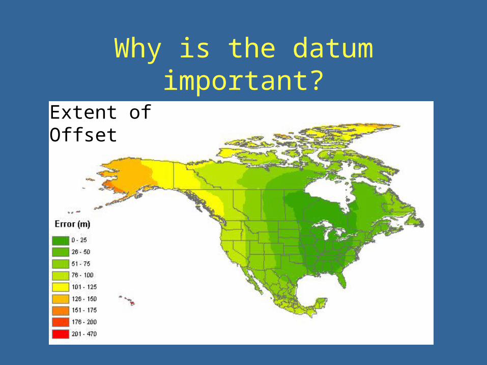
Why is the datum important?
Extent of Offset
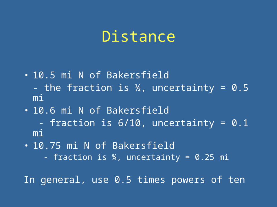
Distance
• 10.5 mi N of Bakersfield- the fraction is ½, uncertainty = 0.5 mi
• 10.6 mi N of Bakersfield - fraction is 6/10, uncertainty = 0.1 mi
• 10.75 mi N of Bakersfield- fraction is ¾, uncertainty = 0.25 mi
In general, use 0.5 times powers of ten

Direction
• 10 mi N of Bakersfield
- uncertainty 45 degrees in either direction• 10 mi NE of Bakersfield
- uncertainty is 22.5 degrees, ENE - NNE• 10 mi N and 5 mi E of Bakersfield
- can ignore directional imprecision

Coordinate Precision
• Too few digits = unnecessary uncertainties • 1° does not equal the same distance
everywhere on the surface of the earth
Precision (degrees) 0 latitude (m) 30 latitude (m) 60 latitude (m)1 156904 146962 124605
0.1 15691 14697 124610.01 1570 1470 1247
0.001 157 147 1250.0001 16 15 13
0.00001 2 2 2
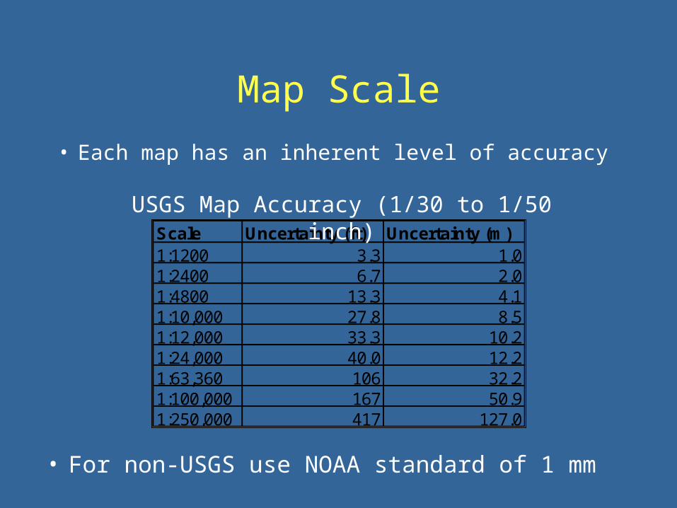
Map Scale
• Each map has an inherent level of accuracy
Scale Uncertainty (ft) Uncertainty (m)1:1200 3.3 1.01:2400 6.7 2.01:4800 13.3 4.11:10,000 27.8 8.51:12,000 33.3 10.21:24,000 40.0 12.21:63,360 106 32.21:100,000 167 50.91:250,000 417 127.0
USGS Map Accuracy (1/30 to 1/50 inch)
• For non-USGS use NOAA standard of 1 mm

Georeferencing Calculator
Example:
1.3 km N, 0.6 km E Confluence Brumley & Pack Creeks, La Sal Mtns, Utah.
http://elib.cs.berkeley.edu/manis/gc.html

Sources of Coordinates
• Maps • Gazetteers• Localities already recorded with coordinates
http://www.indexmundi.com/zp/
http://geonames.usgs.gov/

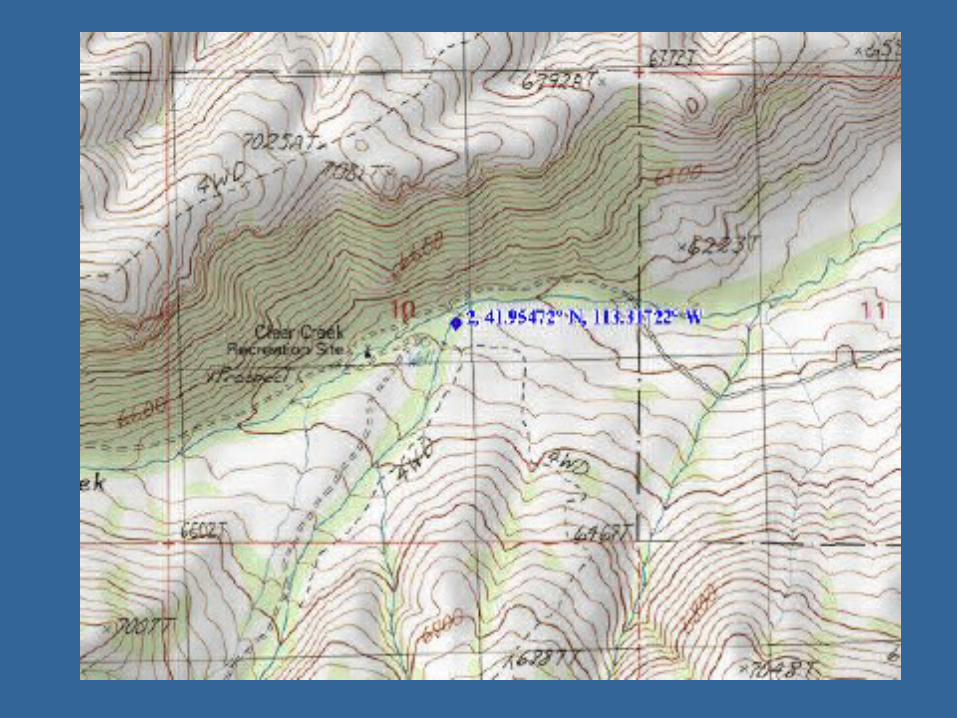
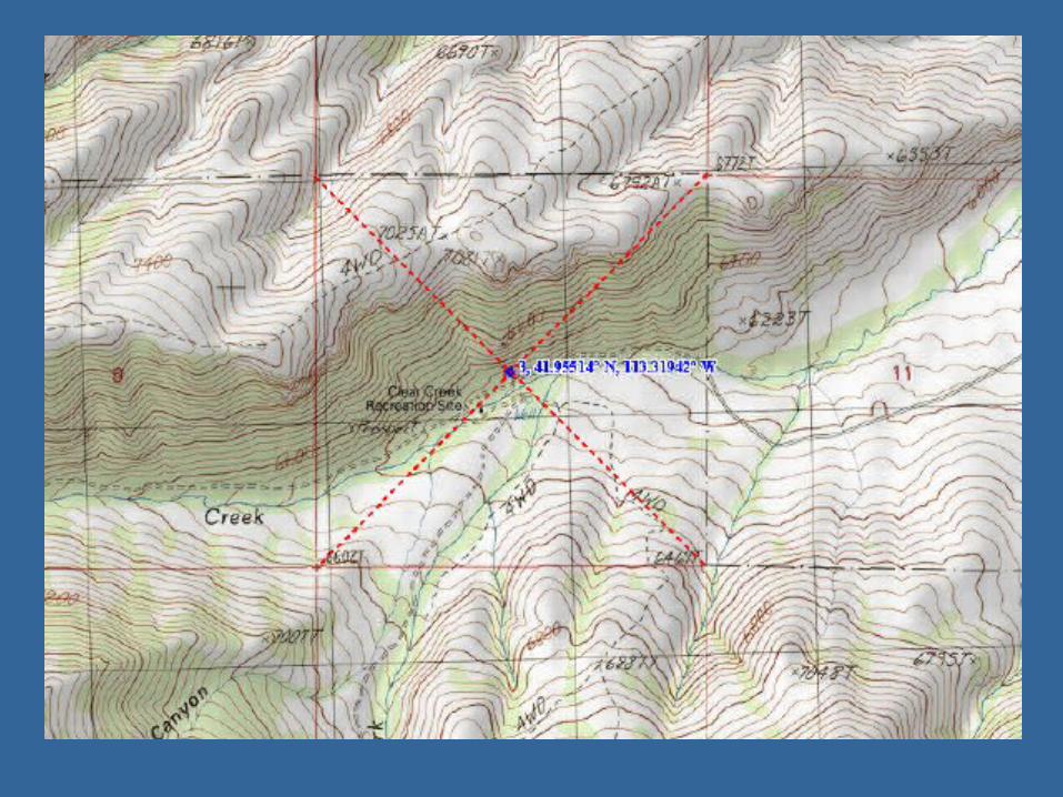
N side Clear Creek Campground, Raft River Mtns, Utah T13N R13W Sec 10
Options:• TRS Converter & pre-established uncertainty
http://www.esg.montana.edu/gl/trs-data.html
• Use a map and measure section geocenter• Georeference to the campground Demonstrate TOPO program
Example
Elevation
• Collector recorded elevation values are not incorporated in the georeferencing process
• There is often no record of source & precision
• Can be helpful guide in identifying errors

Before you start, plan
• Georeferencing is time-consuming
• Georeferencing errors will occur
• Certain descriptors won’t be georeferenced
• A common framework for data collection is essential

Increasing Efficiency
What not to do:
• Do not georeference specimen by specimen!
• Do not treat the collections individually!

Increasing Efficiency
What to do:
• Compile unique localities across all collections
• Divide that list geographically and redistribute
• Use your expertise• Assign georeferencing tasks by small spatial units
(e.g. counties or provinces)
• Within those units sort localities by place name
• Coordinate the purchasing of georeferencing aids

Example
LocalityID Collection SpecLocality GeorefBy DeterminationRef Datum DecLat DecLong308374 UWBM Spirit Lake A Baugh USGS 1:24K Map NAD 27 40.84105 -109.99780165587 UMNH SPIRIT LAKE A Baugh USGS 1:24K Map NAD 27 40.84105 -109.99780151362 UMMZ SPIRIT LAKE A Baugh USGS 1:24K Map NAD 27 40.84105 -109.9978052955 KU SPIRIT LAKE A Baugh USGS 1:24K Map NAD 27 40.84105 -109.9978052956 KU SPIRIT LAKE, 10.5 MI NE OF A Baugh USGS 1:24K Map NAD 27 40.94865 -109.8561252957 KU SPIRIT LAKE, 13 MI NE OF A Baugh USGS 1:24K Map NAD 27 40.97427 -109.8223952958 KU SPIRIT LAKE, 7 MI NE OF A Baugh USGS 1:24K Map NAD 27 40.91278 -109.9033552959 KU SPIRIT LAKE, 7 MI NE OF; HICHERSON PARK A Baugh GNIS Gazateer NAD 27 40.89556 -109.94000
165489 UMNH 1 MI. SE SPIRIT LAKE A Baugh USGS 1:24K Map NAD 27 40.82692 -109.98679165485 UMNH 1 MI. NE SPIRIT LAKE A Baugh USGS 1:24K Map NAD 27 40.85164 -109.98457165498 UMNH 1/4 MI. S SPIRIT LAKE A Baugh USGS 1:24K Map NAD 27 40.83777 -109.99806165542 UMNH E SIDE SPIRIT LAKE A Baugh USGS 1:24K Map NAD 27 40.84139 -109.99671165578 UMNH S SIDE SPIRIT LAKE A Baugh USGS 1:24K Map NAD 27 40.83919 -109.99819165579 UMNH S SIDE SPIRIT LAKE A Baugh USGS 1:24K Map NAD 27 40.83919 -109.99819165588 UMNH SPIRIT LAKE CAMPGROUND A Baugh USGS 1:24K Map NAD 27 40.83734 -109.99967
A Baugh165564 UMNH MIDDLE FORK SHEEP CREEK, 1 MI. N SPIRIT LAKE A Baugh USGS 1:24K Map NAD 27 40.85619 -109.99666165565 UMNH MIDDLE FORK SHEEP CREEK, 1/2 MI. N SPIRIT LAKE A Baugh USGS 1:24K Map NAD 27 40.84965 -109.99936165566 UMNH MIDDLE FORK SHEEP CREEK. 1/2 MI. N SPIRIT LAKE A Baugh USGS 1:24K Map NAD 27 40.84965 -109.99936165567 UMNH MIDDLE FORK, SHEEP CREEK, 1/2 MI. N SPIRIT LAKE A Baugh USGS 1:24K Map NAD 27 40.84965 -109.99936

MaNIS FrameworkLocalityID DecLatCollectionCode DecLongHigherGeog LatDegCounty LatMinSpecLocality LatSecElevationText LatDirMinElev LongDegMaxElev LongMinElevUnits LongSecLatText LongDirLongText UTMZoneTRS UTMEWTownship UTMNSTownshipDir Named PlaceRange ExtentRangeDir MaxErrorDistanceTRSSection MaxErrorUnitsTRSPart LatLongRemarksDetByAgentID CaptiveFlagDeterminedByPerson NoGeorefBecauseDeterminedDate LocalityAnnotationDeterminationRef CoordPrecisionOrigCoordSystem DistPrecisionDatum Remarks

Error detection
Map the coordinates (ArcView):
• Do the coordinates have the correct + or – sign?
• Is the decimal place shifted over (e.g. -111.90000 vs. -1119.0000)
• Does the latitude = longitude or vice versa?
• Do they fall within the correct geographical unit?

Error Checking
Egypt
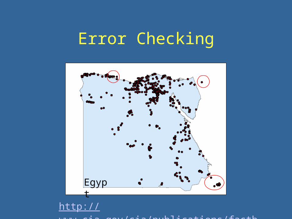
Error Checking
Egypt
http://www.cia.gov/cia/publications/factbook/
Extra slides if TOPO fails