direct georeferencing for photogrammetry
TRANSCRIPT
Direct Georeferencing for PhotogrammetryUsing Inertial Labs INS-B
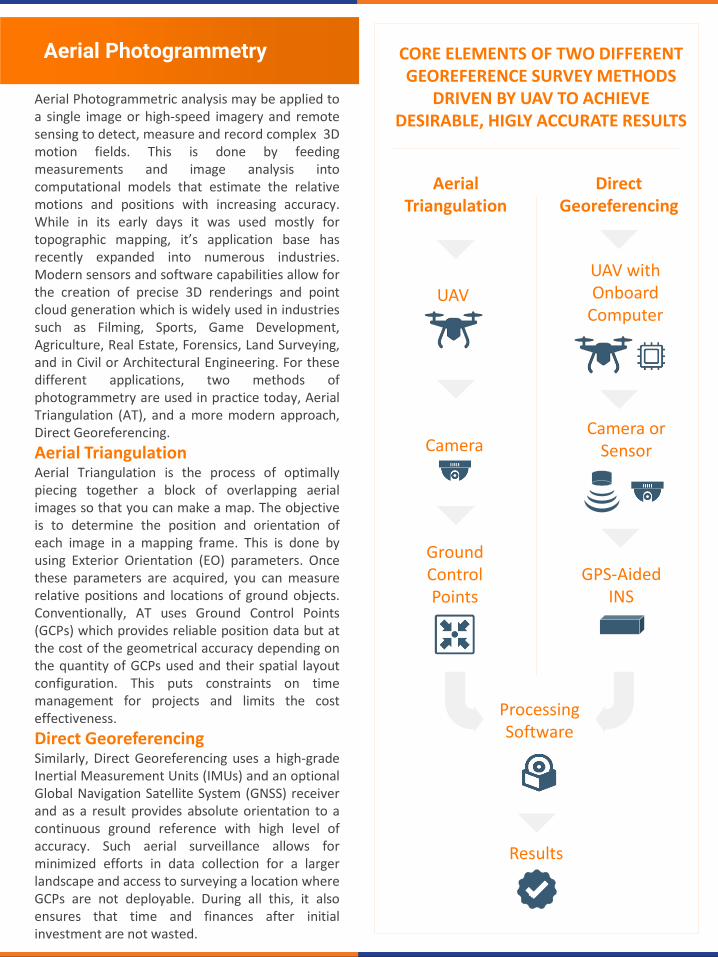
Aerial Photogrammetry
Aerial Photogrammetric analysis may be applied toa single image or high-speed imagery and remotesensing to detect, measure and record complex 3Dmotion fields. This is done by feedingmeasurements and image analysis intocomputational models that estimate the relativemotions and positions with increasing accuracy.While in its early days it was used mostly fortopographic mapping, it’s application base hasrecently expanded into numerous industries.Modern sensors and software capabilities allow forthe creation of precise 3D renderings and pointcloud generation which is widely used in industriessuch as Filming, Sports, Game Development,Agriculture, Real Estate, Forensics, Land Surveying,and in Civil or Architectural Engineering. For thesedifferent applications, two methods ofphotogrammetry are used in practice today, AerialTriangulation (AT), and a more modern approach,Direct Georeferencing.
Aerial TriangulationAerial Triangulation is the process of optimallypiecing together a block of overlapping aerialimages so that you can make a map. The objectiveis to determine the position and orientation ofeach image in a mapping frame. This is done byusing Exterior Orientation (EO) parameters. Oncethese parameters are acquired, you can measurerelative positions and locations of ground objects.Conventionally, AT uses Ground Control Points(GCPs) which provides reliable position data but atthe cost of the geometrical accuracy depending onthe quantity of GCPs used and their spatial layoutconfiguration. This puts constraints on timemanagement for projects and limits the costeffectiveness.
Direct GeoreferencingSimilarly, Direct Georeferencing uses a high-gradeInertial Measurement Units (IMUs) and an optionalGlobal Navigation Satellite System (GNSS) receiverand as a result provides absolute orientation to acontinuous ground reference with high level ofaccuracy. Such aerial surveillance allows forminimized efforts in data collection for a largerlandscape and access to surveying a location whereGCPs are not deployable. During all this, it alsoensures that time and finances after initialinvestment are not wasted.
CORE ELEMENTS OF TWO DIFFERENT GEOREFERENCE SURVEY METHODS
DRIVEN BY UAV TO ACHIEVE DESIRABLE, HIGLY ACCURATE RESULTS
GPS-AidedINS
Processing Software
Ground Control Points
UAV with Onboard
Computer
Camera
UAV
Camera orSensor
Aerial Triangulation
Direct Georeferencing
Results
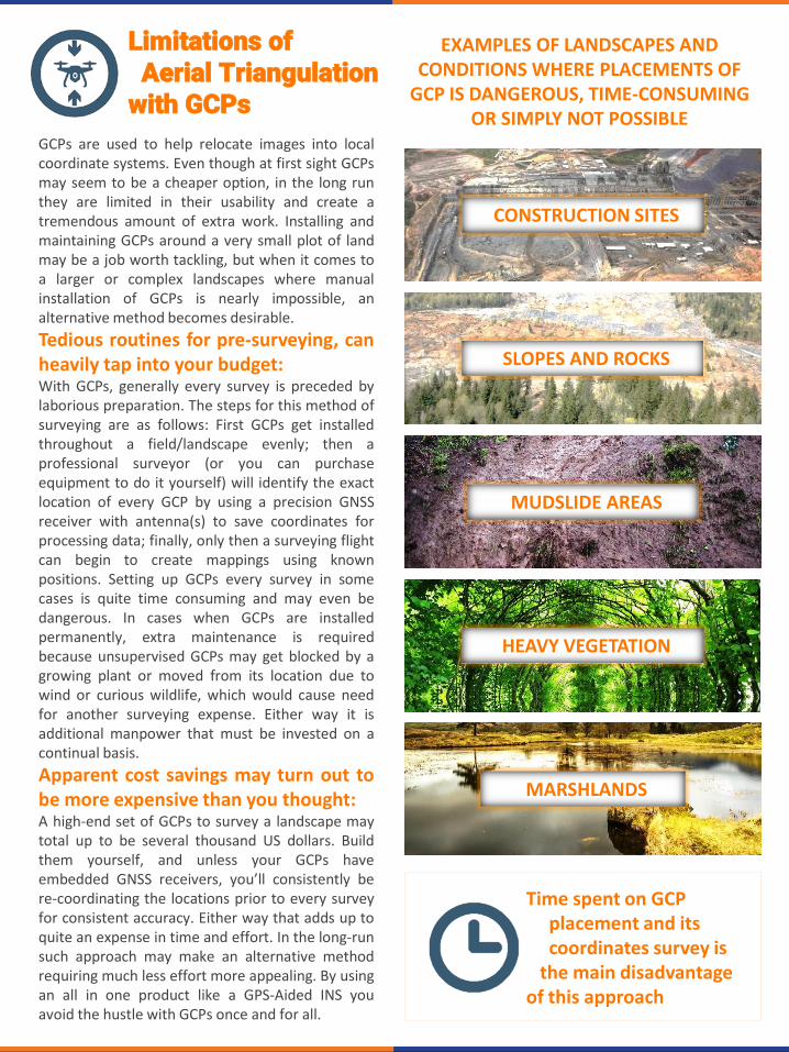
Limitations of Aerial Triangulation
with GCPs
Time spent on GCP placement and its coordinates survey is
the main disadvantage of this approach
EXAMPLES OF LANDSCAPES AND CONDITIONS WHERE PLACEMENTS OF
GCP IS DANGEROUS, TIME-CONSUMING OR SIMPLY NOT POSSIBLE
CONSTRUCTION SITES
MUDSLIDE AREAS
HEAVY VEGETATION
SLOPES AND ROCKS
MARSHLANDS
GCPs are used to help relocate images into localcoordinate systems. Even though at first sight GCPsmay seem to be a cheaper option, in the long runthey are limited in their usability and create atremendous amount of extra work. Installing andmaintaining GCPs around a very small plot of landmay be a job worth tackling, but when it comes toa larger or complex landscapes where manualinstallation of GCPs is nearly impossible, analternative method becomes desirable.
Tedious routines for pre-surveying, canheavily tap into your budget:With GCPs, generally every survey is preceded bylaborious preparation. The steps for this method ofsurveying are as follows: First GCPs get installedthroughout a field/landscape evenly; then aprofessional surveyor (or you can purchaseequipment to do it yourself) will identify the exactlocation of every GCP by using a precision GNSSreceiver with antenna(s) to save coordinates forprocessing data; finally, only then a surveying flightcan begin to create mappings using knownpositions. Setting up GCPs every survey in somecases is quite time consuming and may even bedangerous. In cases when GCPs are installedpermanently, extra maintenance is requiredbecause unsupervised GCPs may get blocked by agrowing plant or moved from its location due towind or curious wildlife, which would cause needfor another surveying expense. Either way it isadditional manpower that must be invested on acontinual basis.
Apparent cost savings may turn out tobe more expensive than you thought:A high-end set of GCPs to survey a landscape maytotal up to be several thousand US dollars. Buildthem yourself, and unless your GCPs haveembedded GNSS receivers, you’ll consistently bere-coordinating the locations prior to every surveyfor consistent accuracy. Either way that adds up toquite an expense in time and effort. In the long-runsuch approach may make an alternative methodrequiring much less effort more appealing. By usingan all in one product like a GPS-Aided INS youavoid the hustle with GCPs once and for all.
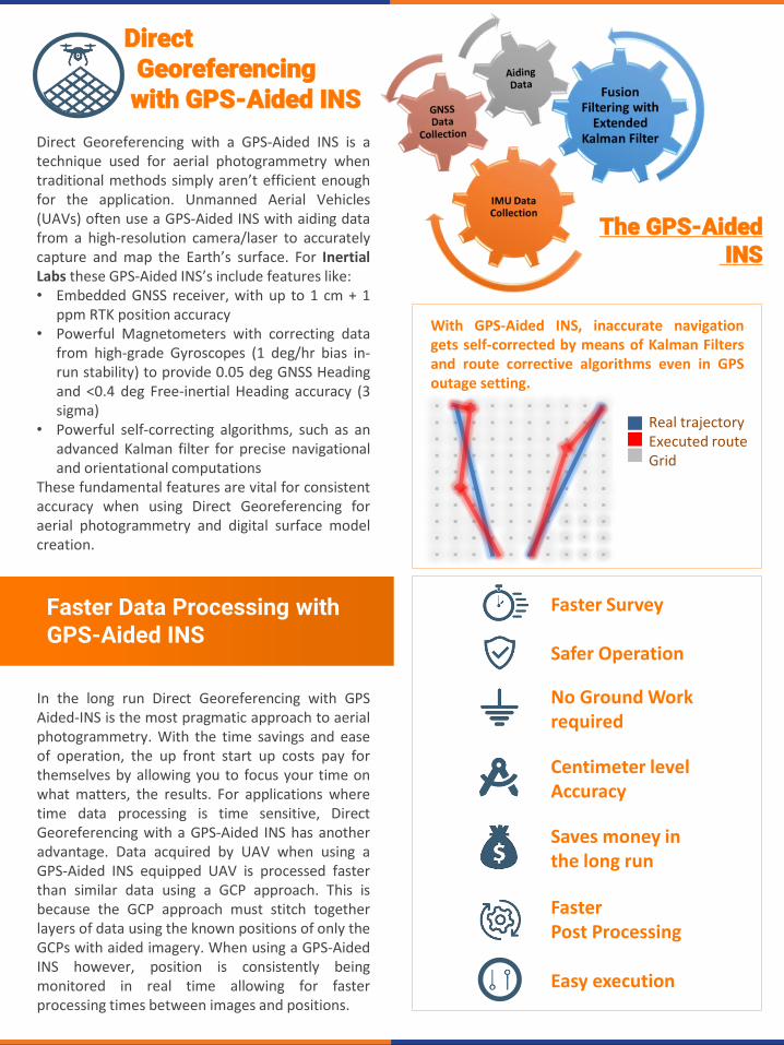
Faster Data Processing with GPS-Aided INS
DirectGeoreferencingwith GPS-Aided INS
Direct Georeferencing with a GPS-Aided INS is atechnique used for aerial photogrammetry whentraditional methods simply aren’t efficient enoughfor the application. Unmanned Aerial Vehicles(UAVs) often use a GPS-Aided INS with aiding datafrom a high-resolution camera/laser to accuratelycapture and map the Earth’s surface. For InertialLabs these GPS-Aided INS’s include features like:• Embedded GNSS receiver, with up to 1 cm + 1
ppm RTK position accuracy• Powerful Magnetometers with correcting data
from high-grade Gyroscopes (1 deg/hr bias in-run stability) to provide 0.05 deg GNSS Headingand <0.4 deg Free-inertial Heading accuracy (3sigma)
• Powerful self-correcting algorithms, such as anadvanced Kalman filter for precise navigationaland orientational computations
These fundamental features are vital for consistentaccuracy when using Direct Georeferencing foraerial photogrammetry and digital surface modelcreation.
In the long run Direct Georeferencing with GPSAided-INS is the most pragmatic approach to aerialphotogrammetry. With the time savings and easeof operation, the up front start up costs pay forthemselves by allowing you to focus your time onwhat matters, the results. For applications wheretime data processing is time sensitive, DirectGeoreferencing with a GPS-Aided INS has anotheradvantage. Data acquired by UAV when using aGPS-Aided INS equipped UAV is processed fasterthan similar data using a GCP approach. This isbecause the GCP approach must stitch togetherlayers of data using the known positions of only theGCPs with aided imagery. When using a GPS-AidedINS however, position is consistently beingmonitored in real time allowing for fasterprocessing times between images and positions.
Faster Survey
Safer Operation
No Ground Work required
Centimeter levelAccuracy
Saves money inthe long run
With GPS-Aided INS, inaccurate navigationgets self-corrected by means of Kalman Filtersand route corrective algorithms even in GPSoutage setting.
Real trajectoryExecuted routeGrid
FasterPost Processing
Easy execution
The GPS-AidedINS

Trademark Legal Notice: All product names, logos, and brands are property of their respective owners. All company, product and service names used in this document are for identification purposes only. Use of names, logos, pictures and brands does not imply endorsement. Mentioned or referenced industries are trademarks of its affiliates or its respective owners, registered in many jurisdictions worldwide.
The Inertial Labs GPS-Aided INS-Bis new generation of: fully-integrated; combinedGPS, GLONASS, GALILEO, QZSS, BEIDOU and L-Bandnavigation; and high-performance strap downsystem that determines Position, Velocity, Pitch,Roll and Yaw with high accuracy for bothmotionless and dynamic applications. It utilizes anadvanced single antenna GNSS receiver,barometer, 3-axes each of calibrated in fulloperational temperature range precisionAccelerometers and Gyroscopes. Its also armoredwith a sensors fusion filter, state of the artnavigation algorithms and calibration software. TheINS-B can even be used as aiding data for opticalcameras, autopilot or Light Detection and Ranging(LiDAR) payloads to further help with taking yourapplication to the next level.
The Value of Investment
INS-Bwith embedded
8 or 64 GB Data Logger
PPK Accuracy
Horizontal Position
0.005 m (RMS)
Velocity 0.03 m/s (RMS)
Pitch and
Roll0.006ᵒ (RMS)
Heading/Yaw 0.03ᵒ (RMS)
Gyro Bias in-run Stability
1 (ᵒ/hr)
Weight 280 grams
Size 120 x 50 x 53 mm
Standalone Solution: INS-B
Depending on the application and factors of theproject there are two main approaches toproducing mappable results. DirectionGeoreferencing using the Inertial Labs INS-Bprovides a solution that mitigates ground work,reduces risk, and produces faster results that areconsistently accurate. For alternative resultsacquired using GCP’s, potential money saved onstartup costs may come at an expense in the longrun in continual maintenance, and repeatedexpenses. For professionals that frequentlyperform routine operations, a GPS-Aided INS-B isthe logical choice for its ease of data acquisition,speed of processing, and accuracy. Time is money;and in an industry where maximizing your ability toautomate unnecessary work comes with heavybenefits, why not take that next step? By doingthis, it allows human resources to be focused onthe things that can’t be automated like interpretingresults and building a larger customer platform.
About Inertial Labs Inc.
Established in 2001, Inertial Labs is a leader in position and orientation technologies for commercial,
industrial, aerospace and defense applications. Inertial Labs has a worldwide distributor and
representative network covering 20+ countries across 6 continents and a standard product line spanning
from Inertial Measurement Units (IMU) to GPS-Aided Inertial Navigation Systems (INS). With application
breadth on Land, Air, and Sea; Inertial Labs covers the gambit of inertial technologies and solutions.
Inertial Labs, Inc.39959 Catoctin Ridge Street,Paeonian Springs, VA 20129 USAphone: +1 (703) 880 [email protected]