geospatial data collection using unmanned aerial system...
TRANSCRIPT

Geospatial Data Collection Using
Unmanned Aerial System (UAS)
Jeff Lovin
Woolpert, Inc.
ASPRS-EGLR Technical Meeting
June 21, 2013

Aerial Sensing Has Come A Long Way!!!
From carrying a
camera…
To carrying an entire aerial
acquisition system
Image courtesy: http://cryptome.org/2012-info/drone-photos/drone-photos.htm

Not All Drones are lethal…
Image courtesy: http://cryptome.org/2012-info/drone-photos/drone-photos.htm

Drones for surveillance and Mapping…
We call them “Unmanned Aerial
System”
Images courtesy: http://cryptome.org/2012-info/drone-photos/drone-photos.htm

The UAS advantages for Geospatial Business
+ Ease of data acquisition
+ Increased ability to map difficult areas or small projects
+ Expeditious data delivery
+ Data sets may be acquired at reduced costs when compared to
traditional field survey or conventional aerial mission
+ It can be metric

Geospatial Market Segment for UAS
+ Mapping and Surveys of corridors
+ Energy Site Mapping
+ Insurance Companies “as is” Plan
+ Engineering, Construction and Forestry
+ Precision Agriculture
+ Environmental Studies
+ Emergency Services
+ Farm Irrigation
+ Site Inspection

Woolpert Strategic Partnership with Altavian
+ Woolpert secured a strategic partnership with a leading company in
the field of UAS manufacturing
+ Woolpert purchased its first UAS in March 2013
+ Purchased the Altavian Nova Block III platform
+ First flight was achieved in April 2013

Why Altavian?
+ Introduced innovative platform for flexible aerial imagery acquisition
+ Leading manufacturer with geospatial background (owner and
founder hold a master degree in photogrammetry);
+ Track record of mapping projects with the US Army
+ US-based operations facilitates fast field support
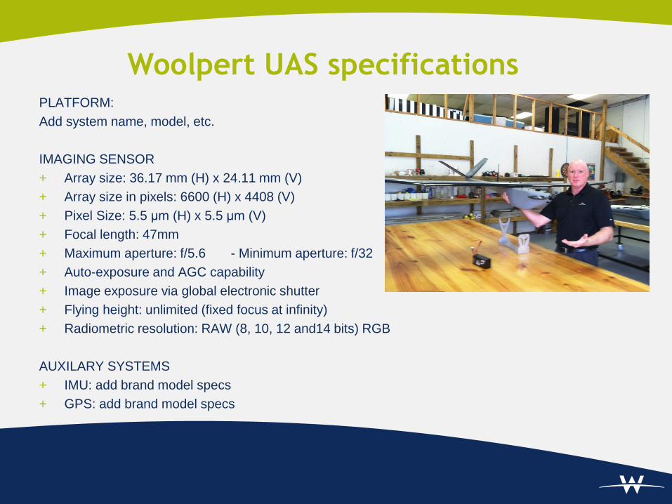
PLATFORM:
Add system name, model, etc.
IMAGING SENSOR
+ Array size: 36.17 mm (H) x 24.11 mm (V)
+ Array size in pixels: 6600 (H) x 4408 (V)
+ Pixel Size: 5.5 μm (H) x 5.5 μm (V)
+ Focal length: 47mm
+ Maximum aperture: f/5.6 - Minimum aperture: f/32
+ Auto-exposure and AGC capability
+ Image exposure via global electronic shutter
+ Flying height: unlimited (fixed focus at infinity)
+ Radiometric resolution: RAW (8, 10, 12 and14 bits) RGB
AUXILARY SYSTEMS
+ IMU: add brand model specs
+ GPS: add brand model specs
Woolpert UAS specifications

Woolpert UAS Characteristics
+ Woolpert is working on procedures and modification to convert the
UAS to a fully metric mapping system through:
+ System Calibration
+ In-situ and Indoor calibration processes
+ Hardening the hardware and stabilize it
+ Follow pure photogrammetric procedures
throughout the entire workflow
+ Automate processing as much as possible
Indoor calibration cage (Image courtesy, RIT)

Initial Testing
+ Processed data over a stock pile site with GSD = 1.5 cm
+ Data processed using the following software:
+ Pix4UAV 3D
+ AgiSOFT
+ EnsoMOSAIC
+ MenciAPS
+ All four software packages provide some degree of automation,
some of which is completely automated process.
+ Some of the packages perform camera self-calibration

Processing Software Evaluation
ⁱ ⁺ ⁱ
⁺
⁺⁺
ⁱⁱ
⁺
⁺⁺⁺
ⁱⁱⁱ
GPU processing enabled
Ability to import >1000 images (TIF, JPG)
Rapid process mode or image coverage verification tools
Camera calibration
Automatic AT / bundle adjustment
Export EO for stereo photogrammetric workstation
Automatic DTM/DSM/dense 3D point cloud generation
UAS Software Features
⁺⁺ 3D point cloud with additional licensing and software (EnsoMOSAIC 3D).
⁺⁺⁺ Limited number of OpenCL enabled devices supported.
Batch processing or scripting
ⁱ Determines initial and refined internal parameters for bundle adjustment.
ⁱⁱ Seamline editor not available.
ⁱⁱⁱ Supports Python API, using Python 3.2 as scripting engine.
⁺ Requires additional software and licensing.
Automatic Radiometric correction, seamlines, orthomosaic
Seamline editor, orthophoto tiling / Google Earth tile setup
3D point cloud viewer and orthomosaic correction editor
Main CAD functionalities and common edit commands
Automatic contour line generation
Pix4UAV 3D Menci APS
Quality Control reported results
Image geometric and radiometric pre-processing
Individual image orthorectification
Agisoft EnsoMOSAIC

Menci APS+ Menci APS is relatively new, the developers are eager to gain market share, and currently are
most willing to implement customer feedback and suggestions to improve their product.
+ During evaluation, required the least amount of processing time, and performed at comparable or
higher accuracies.
+ Does not require knowledge in photogrammetry to operate, can be conducted in the field if
necessary, but is fresh off the presses and will require continued updates with improvements.
Pix4UAV Desktop 3D
+ Pix4D is the most stable of the UAS specific software packages, but such stability
comes at a price in the absence of enhanced functionality or adaptive
integration.During evaluation, required the second least amount of processing time,
and performed at comparable or higher accuracies.
+ Does not require knowledge in photogrammetry to operate, offers bulk secondary
“Pix4UAV Desktop Rapid” licenses for quick turnaround data validation in the field,
but to my knowledge is not GPU enabled and offers limited batch processing
capacity.
Processing Software Evaluation: Conclusion and
Recommendations

Agisoft+ Agisoft has the least amount of photogrammetric components, but calculates comprehensive
internal camera calibration parameters and offers substantial data export options/formats with
batch and scripting capability.
+ During evaluation, required the most processing time and performed at comparable to lower
accuracies.
+ Does not require knowledge in photogrammetry to operate, but is deeply ingrained in 3D modeling
from still photography that it will require considerable trial and error to derive best practices of
use.
EnsoMOSAIC+ EnsoMOSAIC is currently one of the few full photogrammetric software suites optimized for UAS
processing, but it is the most expensive package evaluated and shall primarily offer those with
current photogrammetric capability an unnecessary level of redundancy.
+ During evaluation, required the second most processing time, the most manual interactive process
(setup, parameters, etc.), and performed at comparable to higher accuracies.
+ Requires knowledge in photogrammetry to operate, is not GPU enabled or provide batch/scripting
environment, and to my knowledge does not utilize semi-global matching to from dense 3D
reconstruction.
Processing Software Evaluation: Conclusion and
Recommendations, cont.

Multiple Products System

Ortho Quality (GSD =1.5 cm)

Digital Elevation Model Quality

System Mapping Accuracy
+ Currently, product is meeting class II of ASPRS mapping standard
(RMSE = 6 cm for GSD = 1.5 cm) **
+ Objective: To meet ASPRS class I with the new metric system
(RMSE = 3 cm for GSD = 1.5 cm)
** More testing is need to validate this conclusion

Planned Testing Procedure
Objective:
+ To ensure that the UAS, aircraft, imaging sensor, and associated systems,
function as a fully operational and integrated system;
+ To verify that the UAS adequately meets clients requirements;
+ To perform camera in-situ calibration;
+ To assess and quantify the accuracy and integrity of data derived from the
UAS;
+ To assess overall system capabilities and limitations;
+ To assess operational reliability (through atmospheric and altitude changes,
over time, etc.).
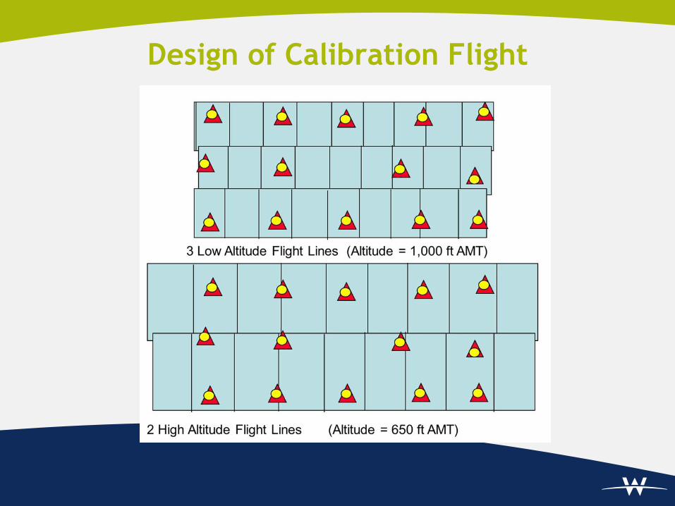
Design of Calibration Flight
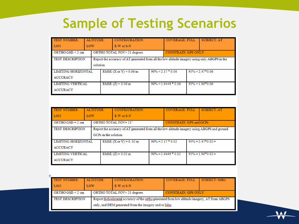
Sample of Testing Scenarios

Future of UAS in Geospatial Industry
+ Once the FAA ease the regulation on flying UASs for commercial
and civilian use, The UAS industry will flourish and so as its use for
mapping.
+ I believe that UAS will gradually replace manned aerial data
acquisition and perhaps it will achieve most of this goal (total
replacement) in the next fifteen years or so.
+ With the increased utilization of UAS and continued automation in
data processing, Geospatial data will be more affordable and data
collection will be achieved in unprecedented time frame.