geotechnical evaluation report - loopnet
TRANSCRIPT

Job Number 2016-162 Kenney Geotechnical Engineering Services PLLC
P.O. Box 117 Warners, NY, 13164, Phone (315)-638-2706, Fax (315)-638-1544, www.kenneygeotechnical.com
GEOTECHNICAL INVESTIGATION REPORT
REDEVELOPMENT PROJECT
1027 EAST GENESEE STREET
SYRACUSE, NEW YORK
PREPARED FOR
THE WOODBINE GROUP
505 EAST FAYETTE STREET
SYRACUSE, NY 13202
FIRM LOGO
PREPARED BY:
KENNEY GEOTECHNICAL
ENGINEERING SERVICES
PLLC
December 1, 2016

Subsurface Investigation Report
Redevelopment Project
1027 E. Genesee St. Syracuse NY
Job Number: 2016-162 Kenney Geotechnical Engineering Services, PLLC
P.O. Box 117 Warners, NY, 13164, Phone (315)-638-2706, Fax (315)-638-1544, www.kenneygeotechnical.com
TABLE OF CONTENTS
INTRODUCTION .......................................................................................................... 1
AUTHORIZATION ........................................................................................................ 1
PROJECT DESCRIPTION .............................................................................................. 1
DESIGN CRITERIA ....................................................................................................... 1
SITE CONDITIONS ...................................................................................................... 2
FIELD STUDY ............................................................................................................... 2
SUBSURFACE CONDITIONS ENCOUNTERED ............................................................. 3
GROUNDWATER CONDITIONS ENCOUNTERED ........................................................ 3
LABORATORY TESTING .............................................................................................. 4
RECOMMENDATIONS AND CONCLUSIONS ............................................................... 4
A. Geotechnical Analysis .................................................................................... 4
B. Foundations Recommendations ..................................................................... 4
C. Earthwork Recommendations ........................................................................ 5
D. Lateral Earth Pressures .................................................................................. 6
E. Reinforced Concrete Slab on Grade .............................................................. 7
F. Lowest Floor Slab ........................................................................................... 7
G. Seismic Hazards Analysis ............................................................................... 8
H. Construction Monitoring ................................................................................ 8
LIMITATIONS .............................................................................................................. 8
REFERENCES .............................................................................................................. 9
ATTACHMENTS –
SUBSURFACE INVESTIGATION LOCATION PLANS
BORING LOGS
LABORATORY TESTING RESULTS

Subsurface Investigation Report
Redevelopment Project
1027 E. Genesee St. Syracuse NY
Job Number: 2016-162 Kenney Geotechnical Engineering Services, PLLC
P.O. Box 117 Warners, NY, 13164, Phone (315)-638-2706, Fax (315)-638-1544, www.kenneygeotechnical.com
INTRODUCTION
This report presents the results of the subsurface investigation performed for the
proposed redevelopment of the former Ronald McDonald House property at 1027
East Genesee St. in Syracuse NY. The scope of our services was developed through
discussions with Mr. Brian St. Laurent, Vice President of Real Estate Development of
the Woodbine Group.
No environmental services are included in this study. No conclusions have been
drawn regarding environmental conditions of the site, potential contaminants,
potential special treatment or disposal of site materials, or other environmental
considerations.
AUTHORIZATION
Our services for this project were authorized by Brian St. Laurent of the Woodbine
Group in an email dated November 13, 2016. The scope of our services was
presented in a proposal addressed to Mr. St. Laurent dated November 9, 2016.
PROJECT DESCRIPTION
It is our understanding that the subject property is being considered for re-
development for student housing. No specific design information has been
developed currently. The geotechnical investigation was developed to gain a
general understanding of site conditions.
DESIGN CRITERIA
Relative ground elevations were measured and used in our analysis. Structural
loading information was not available at the time of our analysis. An assumed
differential and overall settlement tolerance of 0.75 and 1 inch respectively was used
for analysis.
The following ASTM Standards were utilized during this study:
• ASTM D1586 “Penetration Test and Split-Barrel Sampling of Soils”
• ASTM D2487 “Standard Practice for Classification of Soils for Engineering
Purposes (Unified Soil Classification System)”
• ASTM D5434 “Standard Guide for Field Logging of Subsurface Exploration of
Soil and Rock”
Local geotechnical practices were followed during the performance of this

Subsurface Investigation Report
Redevelopment Project
1027 E. Genesee St. Syracuse NY
Job Number: 2016-162 Kenney Geotechnical Engineering Services, PLLC
P.O. Box 117 Warners, NY, 13164, Phone (315)-638-2706, Fax (315)-638-1544, www.kenneygeotechnical.com
investigation.
SITE CONDITIONS
The project site is located on a hillside at the northeast corner of the city of Syracuse.
The site is currently occupied by two three story wood frame buildings connected
by a breezeway. A parking lot and small lawn area are located on the north end of
the property. The parking area slopes gradually to the west approximately 4 feet.
Elevations surrounding the property are considerably varied. At the North and East
borders of the property, elevations increase approximately 5 to 8 feet with slopes of
approximately 0.5:1. At the West border of the property elevations decrease
approximately 2 to 8 feet with a retaining wall extending from the northwest corner
approximately 70 feet.
The site lies at the interface between the Erie-Ontario Lowlands and the Allegheny
Platea physiographic provinces. Major topographic and geologic features in this
area were formed during the last glacial advance and retreat, which ended
approximately 12,000 years ago. Regional surficial geologic mapping suggests that
soils in the site vicinity generally consist of glacial till. Bedrock mapping suggests
that Camillus formation shale underlies soil in the area.
FIELD STUDY
The geotechnical investigation for this site consisted of seven borings (B-1 through
B-7). Boring locations were selected and field located by Kenney Geotechnical
personnel. Elevations for each boring were also measured by Kenney Geotechnical
personnel at each boring location using a selected temporary benchmark. The
temporary benchmark utilized was the sewer grate located on East Genesee street
south of the existing driveway and was assumed an elevation of EL. 100 feet. The
attached boring location plan and boring logs depict the location and relative
elevation for each boring location.
Borings were advanced to a depth of 30 feet or to auger refusal. Hollow stem
augering techniques were utilized to advance the borings. Standard penetration
testing (ASTM D1586) was performed to obtain soil samples. Borings were
advanced by using a track-mounted Geoprobe 7822DT drill rig equipped with an
automatic sampling hammer. The boreholes were backfilled with cuttings and
capped with a concrete plug following the completion of work.
Soil samples obtained during the subsurface investigation were classified using the
Unified Soil Classification System. Boring logs documenting the subsurface
conditions encountered are attached.

Subsurface Investigation Report
Redevelopment Project
1027 E. Genesee St. Syracuse NY
Job Number: 2016-162 Kenney Geotechnical Engineering Services, PLLC
P.O. Box 117 Warners, NY, 13164, Phone (315)-638-2706, Fax (315)-638-1544, www.kenneygeotechnical.com
The boring logs and related information depict subsurface conditions only at the
specific locations and times indicated. Subsurface conditions and water levels at
other locations may differ from conditions at the locations where sampling was
conducted. The passage of time also may result in changes in the conditions
interpreted to exist at the locations where sampling was performed.
SUBSURFACE CONDITIONS ENCOUNTERED
The following interpretation of subsurface conditions is based on our review of the
recovered samples, laboratory testing results, and our professional experience.
The subsurface conditions encountered generally consisted of Fill underlain by
Glacial Till. The Fill stratum extends to depths of four to seven feet below the
ground surface. The Fill layer consisted predominantly of silty sand and gravel and
re-worked glacial till. The Glacial Till was encountered below the fill and extended
throughout the remainder of the test borings. The Glacial Till was found to be very
stiff to hard sandy clay with gravel with N values ranging from 19 to 100 blows per
foot. A maximum unconfined compressive strength of 14,200 psf was measured on a
glacial till sample obtained from boring B-2 between depths of 23 and 25 feet.
Borings B-1 and B-3 encountered saturated lenses of dense sand and gravel within
the Glacial Till at depths of 8.5 and 13.5 feet respectively. The lenses were found to
be approximately 1.5 feet thick. Approximate moisture contents of the samples
obtained within the sand and gravel seams in borings B-1 and B-3 were found be
10.0% and 9.1% respectively.
GROUNDWATER CONDITIONS ENCOUNTERED
Groundwater was only detected within the sand and gravel lenses encountered in
the glacial till at boring locations B-1 and B-3. Borings B-1 and B-3 caved in up to just
below the sand and gravel lenses and encountered water level readings one foot
above the cave in at 10.0 and 15.2 feet respectively. Approximately 40 minutes
elapsed between the removal of the casing and the measurement of the water level.
The groundwater table will vary with the seasons and changes in precipitation
patterns and may be higher during the wetter seasons. No long term groundwater
data was generated during this study and the range of possible groundwater
elevation is unknown.

Subsurface Investigation Report
Redevelopment Project
1027 E. Genesee St. Syracuse NY
Job Number: 2016-162 Kenney Geotechnical Engineering Services, PLLC
P.O. Box 117 Warners, NY, 13164, Phone (315)-638-2706, Fax (315)-638-1544, www.kenneygeotechnical.com
LABORATORY SOIL TESTING
Laboratory testing performed for this project included Particle Size Analysis (ASTM
D-422), Water Content (ASTM D-2216), and Unconfined Compressive Strength
(ASTM D2166). Testing was performed in Kenney Geotechnical Services’
laboratory. Test results are attached to this report.
RECOMMENDATIONS AND CONCLUSIONS
A. Geotechnical Analysis
We anticipate that shallow foundations can be utilized to support future buildings
using the hard glacial till as a bearing stratum. We recommend that isolated shallow
foundations are designed for an allowable bearing pressure of 3,500 lbs./sq.ft, and
that continuous footings are designed for and allowable bearing pressure of 4,000
lbs./sq.ft. Foundations cannot bear on the uncontrolled fill stratum, which extends to
depths of seven feet. Over-excavation and replacement of uncontrolled fill with
compacted engineered fill may be necessary. Several steep slopes and a retaining
wall are present around the perimeter of the property. It is recommended that the
stability of the slopes is evaluated as part of the design process for new structures.
B. Foundation Recommendations
The glacial till can provide an allowable bearing pressure of up to 4,000 psf if
properly managed during construction. Uncontrolled fill, and disturbed/saturated
glacial till cannot be utilized to support structures. Over-excavation and
replacement with compacted structural fill may be necessary where uncontrolled fill
is encountered below foundation bearing grade. Foundations must bear at least 48
inches below finished grade for frost protection.
The Glacial Till contains silt and clay and will weaken if allowed to be disturbed by
moisture or other construction operations. Bearing grade soils should not be
exposed to frost or precipitation. Concrete should be poured within 48 hours
following excavation that exposes bearing grade soils. Large cobbles or boulders
should not come in direct contact with the foundation bottom to prevent point-
loading. It is recommended that bearing grade in the Glacial Till is undercut a
minimum of 6 inches and that a lift of compacted crusher-run limestone is placed to
limit point loading and moisture disturbance.

Subsurface Investigation Report
Redevelopment Project
1027 E. Genesee St. Syracuse NY
Job Number: 2016-162 Kenney Geotechnical Engineering Services, PLLC
P.O. Box 117 Warners, NY, 13164, Phone (315)-638-2706, Fax (315)-638-1544, www.kenneygeotechnical.com
C. Earthwork Recommendations
It is recommended that earthwork is performed using materials and methods that
will result in stable excavations, dewatering as necessary, stabilized bearing
subgrades and compacted backfills to grade. Typical temporary earthwork
measures can be anticipated to be employed at this site, for prevailing dry weather
conditions. Presented construction phase earthwork recommendations are as
follows:
1. Remove or strip existing pavement, uncontrolled fill, vegetation and topsoil
from all areas that will be impacted for the entire project construction.
2. Retain a geotechnical engineer to review exposed conditions.
3. Proof-roll the subgrade for pavements using a fully laden 20-ton dump truck
or approved equal under the observation of geotechnical personnel.
Excavate and replace areas that weave or deflect as directed by geotechnical
personnel.
4. Excavated on-site soil may be re-utilized as structural fill with approval from
the design engineer.
5. Site grading must direct runoff away from the foundation, floor slab and all
other structural subgrades. Contractors should anticipate the need to control
and manage subsurface water during earthwork if excavations are to extend
past eight feet from the current ground level due to the sand and gravel
lenses present within the till. Stormwater diversion measures should be
installed to prevent runoff from flowing towards excavations and the proposed
foundation or other subgrades. Water cannot be allowed to pond within
foundation excavations and must be immediately removed. Any groundwater
collection during construction must be managed in accordance with New York
State discharge regulations.
6. Field moisture contents for structural fill should be maintained within 2
percentage points of the optimum moisture content established by laboratory
testing to provide adequate compaction. All fill should be placed in level lifts
having a loose thickness no greater than 12 inches and should be compacted
with vibratory rollers to at least the following minimum percentages of the
Modified Proctor (ASTM D-1557, Method C) maximum dry density:
• Beneath slab-on-grade or pavements: 95%
• Beneath exterior slabs and sidewalks: 95%
Subsurface Investigation Report
Redevelopment Project
1027 E. Genesee St. Syracuse NY
Job Number: 2016-162 Kenney Geotechnical Engineering Services, PLLC
P.O. Box 117 Warners, NY, 13164, Phone (315)-638-2706, Fax (315)-638-1544, www.kenneygeotechnical.com
• Utility trench backfill: 95%
• Beneath landscape areas: 90%
7. Temporary excavation slopes must be evaluated by the Contractor’s on-site
Responsible Person. We anticipate that the site soils encountered will be
classified as Type C soils for uncontrolled fill and Type A soils for glacial till.
Type C materials must be graded to slopes no greater than 1.5:1 (horizontal to
vertical) during excavation. Type A soils must be graded to slopes no greater
than 0.75:1 (horizontal to vertical). The Contractor must continually re-
evaluate slopes to ensure safe conditions exist for all on-site personnel.
Consideration should be given to applying diversion measures for and sheets
of polyethylene as cover to cuts slopes in soil to prevent washouts during rain
events.
8. Structural Fill for stabilization working mats should of imported granular
material conforming to NYSDOT Specification Item 304.12 Type 2 or Item
304.14 Type 4 or approved equal.
9. In-place density testing should be performed at a frequency of one test per
500 square feet per lift in proposed building areas and one test per 25 feet per
lift in trenches.
10. For utility trenches or other confined areas, small compaction equipment may
be necessary such as a vibratory plate, jumping jack or walk-behind vibratory
roller. In these cases, lift heights no greater than 6 inches should be
maintained.
11. If the structure is to be constructed during the winter months, or if the building
interiors will be subjected to freezing temperatures after footer construction,
adequate frost cover and protection must be provided. Earthwork cannot be
performed with frozen material.
D. Lateral Earth Pressures
Adjacent slopes and the existing retaining wall will need to be analyzed when
details of the proposed structure are available. Using building loads, soil properties
and measurements a slope stability analysis will be necessary to gain insight on
possible measures that will need to be taken. Hard glacial till is generally able to
openly graded at 3:1 but further measurement and analysis of the surrounding
slopes will need be evaluated.
Subsurface Investigation Report
Redevelopment Project
1027 E. Genesee St. Syracuse NY
Job Number: 2016-162 Kenney Geotechnical Engineering Services, PLLC
P.O. Box 117 Warners, NY, 13164, Phone (315)-638-2706, Fax (315)-638-1544, www.kenneygeotechnical.com
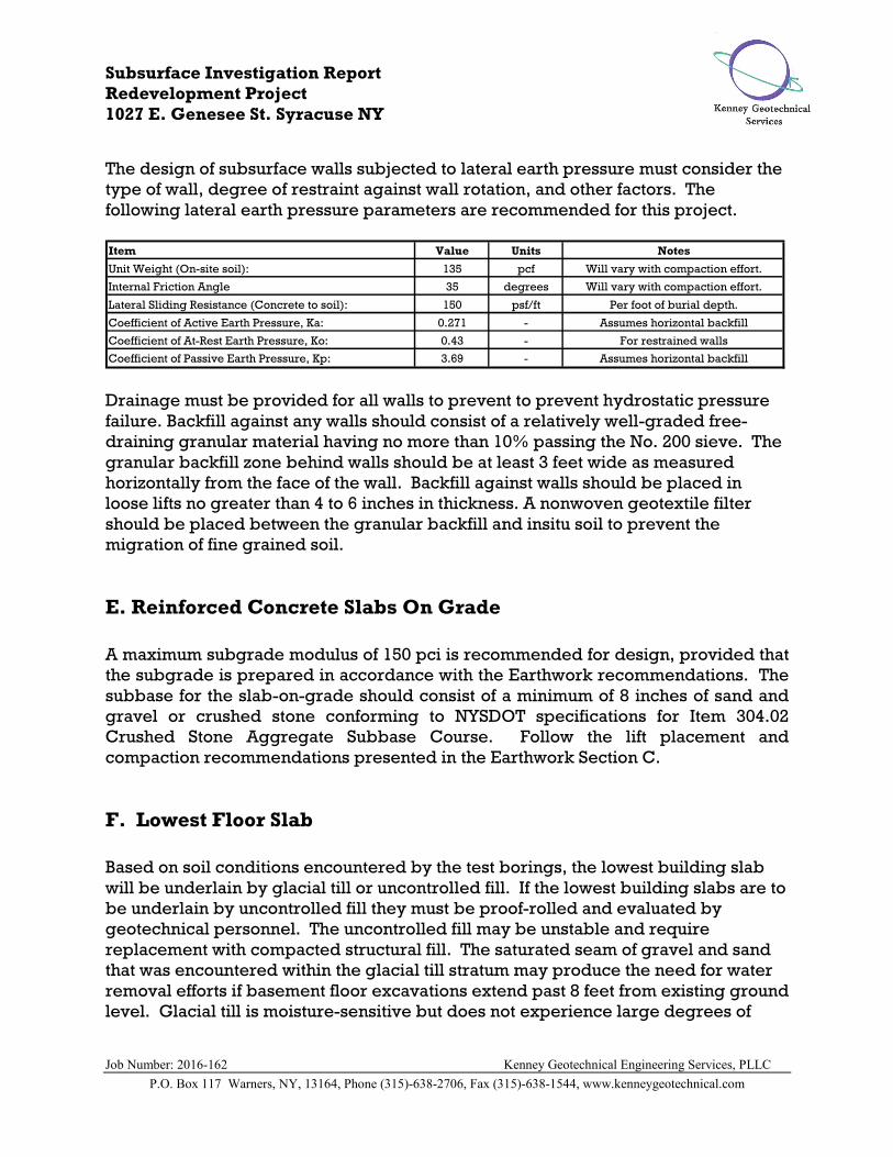
The design of subsurface walls subjected to lateral earth pressure must consider the
type of wall, degree of restraint against wall rotation, and other factors. The
following lateral earth pressure parameters are recommended for this project.
Item Value Units
Unit Weight (On-site soil): 135 pcf
Internal Friction Angle 35 degrees
Lateral Sliding Resistance (Concrete to soil): 150 psf/ft
Coefficient of Active Earth Pressure, Ka: 0.271 -
Coefficient of At-Rest Earth Pressure, Ko: 0.43 -
Coefficient of Passive Earth Pressure, Kp: 3.69 - Assumes horizontal backfill
Will vary with compaction effort.
Will vary with compaction effort.
Notes
Per foot of burial depth.
Assumes horizontal backfill
For restrained walls
Drainage must be provided for all walls to prevent to prevent hydrostatic pressure
failure. Backfill against any walls should consist of a relatively well-graded free-
draining granular material having no more than 10% passing the No. 200 sieve. The
granular backfill zone behind walls should be at least 3 feet wide as measured
horizontally from the face of the wall. Backfill against walls should be placed in
loose lifts no greater than 4 to 6 inches in thickness. A nonwoven geotextile filter
should be placed between the granular backfill and insitu soil to prevent the
migration of fine grained soil.
E. Reinforced Concrete Slabs On Grade
A maximum subgrade modulus of 150 pci is recommended for design, provided that
the subgrade is prepared in accordance with the Earthwork recommendations. The
subbase for the slab-on-grade should consist of a minimum of 8 inches of sand and
gravel or crushed stone conforming to NYSDOT specifications for Item 304.02
Crushed Stone Aggregate Subbase Course. Follow the lift placement and
compaction recommendations presented in the Earthwork Section C.
F. Lowest Floor Slab
Based on soil conditions encountered by the test borings, the lowest building slab
will be underlain by glacial till or uncontrolled fill. If the lowest building slabs are to
be underlain by uncontrolled fill they must be proof-rolled and evaluated by
geotechnical personnel. The uncontrolled fill may be unstable and require
replacement with compacted structural fill. The saturated seam of gravel and sand
that was encountered within the glacial till stratum may produce the need for water
removal efforts if basement floor excavations extend past 8 feet from existing ground
level. Glacial till is moisture-sensitive but does not experience large degrees of

Subsurface Investigation Report
Redevelopment Project
1027 E. Genesee St. Syracuse NY
Job Number: 2016-162 Kenney Geotechnical Engineering Services, PLLC
P.O. Box 117 Warners, NY, 13164, Phone (315)-638-2706, Fax (315)-638-1544, www.kenneygeotechnical.com
shrinkage or expansion. The following recommendations are presented for
preparation of the slab subgrade.
1. Remove existing earthen materials to 12 inches below the proposed slab
subgrade elevation.
2. Allow geotechnical personnel to review exposed subgrade conditions.
3. If approved by geotechnical personnel, place a woven geotextile and 12
inches of compacted structural fill to establish new slab subgrade. The
structural fill should consist of well-graded crushed stone conforming to
NYSDOT specifications for Item 304-2.02 Type 2 or 4. Follow compaction
requirements presented for earthwork.
4. We suggest the concrete floor slab is designed for a subgrade modulus of
125 pci in areas where fill is present at subgrade. If undisturbed Till is
present at subgrade, a subgrade modulus of 200 pci is recommended.
5. Provide a vapor barrier beneath the slab-on-grade if impermeable floor
finishes are used. If a vapor barrier is utilized, a 3-inch thick layer of sand
should be placed at slab subgrade. In this case, the structural fill
thickness would be 9 inches.
G. Seismic Hazards Analysis
Based upon the data generated during this investigation, it is our opinion that Site
Class D is appropriate for the project site. The estimated design spectral response
acceleration parameters are SDS = .150g and SD1 = .082g. Please note that the site
class may need to be modified if changed subsurface conditions are encountered
during construction. Liquefaction, surface rupture from faulting or lateral spreading
is estimated to have a low probability of occurrence given the soil conditions
encountered and typical regional seismicity.
H. Construction Monitoring
The geotechnical recommendations presented in this report are predicated on the
anticipated performance of construction observation and field and laboratory testing
by geotechnical personnel from Kenney Geotechnical Engineering Services, PLLC
(KGES). We request continued involvement with this project so that we may assess
subsurface conditions exposed during construction to determine if modifications to
our recommendations as presented herein are necessary.
LIMITATIONS
The recommendations presented in this report are predicated on the performance of
construction observation and testing by qualified geotechnical personnel. We

Subsurface Investigation Report
Redevelopment Project
1027 E. Genesee St. Syracuse NY
Job Number: 2016-162 Kenney Geotechnical Engineering Services, PLLC
P.O. Box 117 Warners, NY, 13164, Phone (315)-638-2706, Fax (315)-638-1544, www.kenneygeotechnical.com
request continued involvement with this project so that we may assess subsurface
conditions exposed during construction to determine if modifications to our
recommendations are necessary.
REFERENCES
“Surficial Geologic Map of New York – Finger Lakes Sheet”, New York State
Museum, 1986.
“Bedrock Map of New York – Finger Lakes Sheet”, New York State Museum, 1970.
1
2
3
4
5
6
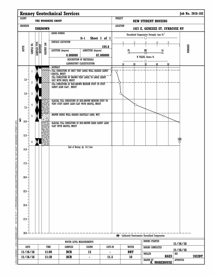
ASPHALT
FILL CONSISTING OF GREY VERY LOOSE WELL GRADED SANDYGRAVEL, MOIST
FILL CONSISTING OF BROWN VERY LOOSE TO LOOSE SANDYSILT WITH BRICK, MOIST
FILL CONSISTING OF RED-BROWN MEDIUM STIFF TO STIFFSANDY LEAN CLAY , MOIST
GLACIAL TILL CONSISTING OF RED-BROWN MEDIUM STIFF TOVERY STIFF SANDY LEAN CLAY WITH GRAVEL, MOIST
BROWN DENSE WELL GRADED GRAVELLY SAND, WET
GLACIAL TILL CONSISTING OF RED-BROWN HARD SANDY LEANCLAY WITH GRAVEL, MOIST
End of Boring @ 14.3 feet
WATER LEVEL MEASUREMENTS BORING STARTED
BORING COMPLETED
11/16/16
11/16/16DRILLER
KGESRIG
7822DTAPPROVED
N. MOREHOUSEDRAWN BY
WATERCAVE-INCASINGSAMPLEDTIMEDATE
CLIENT
ENGINEER
PROJECT
LOCATION
NEW STUDENT HOUSING
1 2 3 4 5
B-1
THE WOODBINE GROUP
BORING NUMBER
SURFACE ELEVATION
104.6
Sheet 1 of 1
UNKNOWN
Calibrated Penetrometer Unconfined Compression
LATITUDE (degrees)
Kenney Geotechnical Services Job No. 2016-162
SAMPL
E NO.
DESCRIPTION OF MATERIALS
(LABORATORY CLASSIFICATION)
REMAR
KS
N VALUE, blows/ft.
10 20 30 40 50
PL LLMC
Unconfined Compressive Strength, tons/ft.2
DEPT
H
2.5
5.0
7.5
10.0
12.5
15.0
17.5
20.0
22.5
25.0
27.5
30.0
SAMPL
ER TYP
ERE
COVE
RY
GRAP
HIC LOG
0.000000 87.000000
1027 E. GENESEE ST. SYRACUSE NY
LONGITUDE (degrees)
LO
G A
GN
GN
03
- L
OG
A G
NG
N0
3.G
DT
- 1
2/1
/16
15
:17
- C
:\P
RO
GR
AM
FIL
ES
(X
86
)\G
INT
\PR
OJE
CT
S\2
01
6-1
62
10
27
EA
ST
GE
NE
SE
EE
ST
RE
ET
.GP
J
11/16/16
11/16/16
11:00
11:30
BCR
ACR
13
-
-
11.5
DRY
10
ACR
100
1
2
3
4
5
6
7
8
9
ASPHALT
FILL CONSISTING OF GREY VERY LOOSE WELL GRADED SANDYGRAVEL, MOIST
FILL CONSISTING OF BROWN LOOSE TO MEDIUM DENSE SANDYSILT, MOIST
GLACIAL TILL CONSISTING OF RED-BROWN VERY STIFF TOHARD SANDY LEAN CLAY WITH GRAVEL, MOIST
GLACIAL TILL CONSISTING OF PURPLE-GREY HARD SANDYLEAN CLAY WITH GRAVEL, MOIST
End of Boring @ 30 feet
WATER LEVEL MEASUREMENTS BORING STARTED
BORING COMPLETED
11/17/16
11/17/16DRILLER
KGESRIG
7822DTAPPROVED
N. MOREHOUSEDRAWN BY
WATERCAVE-INCASINGSAMPLEDTIMEDATE
CLIENT
ENGINEER
PROJECT
LOCATION
NEW STUDENT HOUSING
1 2 3 4 5
B-2
THE WOODBINE GROUP
BORING NUMBER
SURFACE ELEVATION
107.8
Sheet 1 of 1
UNKNOWN
Calibrated Penetrometer Unconfined Compression
LATITUDE (degrees)
Kenney Geotechnical Services Job No. 2016-162
SAMPL
E NO.
DESCRIPTION OF MATERIALS
(LABORATORY CLASSIFICATION)
REMAR
KS
N VALUE, blows/ft.
10 20 30 40 50
PL LLMC
Unconfined Compressive Strength, tons/ft.2
DEPT
H
2.5
5.0
7.5
10.0
12.5
15.0
17.5
20.0
22.5
25.0
27.5
30.0
SAMPL
ER TYP
ERE
COVE
RY
GRAP
HIC LOG
47.000000 -2.000000
1027 E. GENESEE ST. SYRACUSE NY
LONGITUDE (degrees)
LO
G A
GN
GN
03
- L
OG
A G
NG
N0
3.G
DT
- 1
2/1
/16
15
:17
- C
:\P
RO
GR
AM
FIL
ES
(X
86
)\G
INT
\PR
OJE
CT
S\2
01
6-1
62
10
27
EA
ST
GE
NE
SE
EE
ST
RE
ET
.GP
J
11/17/16
11/17/16
11:00
11:30
BCR
ACR
28
-
-
19.5
DRY
DRY

1
2
3
4
5
6
7
8
ASPHALT
FILL CONSISTING OF GREY VERY LOOSE WELL GRADED SANDYGRAVEL, MOIST
FILL CONSISTING OF RED-BROWN STIFF TO VERY STIFFSANDY LEAN CLAY, MOIST
GLACIAL TILL CONSISTING OF RED-BROWN HARD SANDY LEANCLAY WITH GRAVEL, MOIST
GLACIAL TILL CONSISTING OF PURPLE-GREY HARD SANDYLEAN CLAY WITH GRAVEL, MOIST
GREY DENSE WELL GRADED CLAYEY SAND WITH GRAVEL,WET
GLACIAL TILL CONSISTING OF PURPLE-GREY HARD SANDYLEAN CLAY WITH GRAVEL, MOIST
End of Boring @ 20.7 feet
WATER LEVEL MEASUREMENTS BORING STARTED
BORING COMPLETED
11/17/16
11/17/16DRILLER
KGESRIG
7822DTAPPROVED
N. MOREHOUSEDRAWN BY
WATERCAVE-INCASINGSAMPLEDTIMEDATE
CLIENT
ENGINEER
PROJECT
LOCATION
NEW STUDENT HOUSING
1 2 3 4 5
B-3
THE WOODBINE GROUP
BORING NUMBER
SURFACE ELEVATION
107.7
Sheet 1 of 1
UNKNOWN
Calibrated Penetrometer Unconfined Compression
LATITUDE (degrees)
Kenney Geotechnical Services Job No. 2016-162
SAMPL
E NO.
DESCRIPTION OF MATERIALS
(LABORATORY CLASSIFICATION)
REMAR
KS
N VALUE, blows/ft.
10 20 30 40 50
PL LLMC
Unconfined Compressive Strength, tons/ft.2
DEPT
H
2.5
5.0
7.5
10.0
12.5
15.0
17.5
20.0
22.5
25.0
27.5
30.0
SAMPL
ER TYP
ERE
COVE
RY
GRAP
HIC LOG
47.000000 42.000000
1027 E. GENESEE ST. SYRACUSE NY
LONGITUDE (degrees)
LO
G A
GN
GN
03
- L
OG
A G
NG
N0
3.G
DT
- 1
2/1
/16
15
:17
- C
:\P
RO
GR
AM
FIL
ES
(X
86
)\G
INT
\PR
OJE
CT
S\2
01
6-1
62
10
27
EA
ST
GE
NE
SE
EE
ST
RE
ET
.GP
J
11/17/16
11/17/16
13:00
13:30
BCR
ACR
20
-
-
16.2
DRY
15.2
ACR
100
100

1
2
3
4
5
6
7
8
ASPHALT
FILL CONSISTING OF GREY VERY LOOSE WELL GRADED SANDYGRAVEL, MOIST
FILL CONSISTING OF RED-BROWN MEDIUM STIFF SANDY LEANCLAY WITH GRAVEL, MOIST
GLACIAL TILL CONSISTING OF RED-BROWN HARD SANDY LEANCLAY WITH GRAVEL, MOIST
GLACIAL TILL CONSISTING OF PURPLE-GREY HARD SANDYLEAN CLAY WITH GRAVEL, MOIST
End of Boring @ 24 feet
WATER LEVEL MEASUREMENTS BORING STARTED
BORING COMPLETED
11/17/16
11/17/16DRILLER
KGESRIG
7822DTAPPROVED
N. MOREHOUSEDRAWN BY
WATERCAVE-INCASINGSAMPLEDTIMEDATE
CLIENT
ENGINEER
PROJECT
LOCATION
NEW STUDENT HOUSING
1 2 3 4 5
B-4
THE WOODBINE GROUP
BORING NUMBER
SURFACE ELEVATION
107.5
Sheet 1 of 1
UNKNOWN
Calibrated Penetrometer Unconfined Compression
LATITUDE (degrees)
Kenney Geotechnical Services Job No. 2016-162
SAMPL
E NO.
DESCRIPTION OF MATERIALS
(LABORATORY CLASSIFICATION)
REMAR
KS
N VALUE, blows/ft.
10 20 30 40 50
PL LLMC
Unconfined Compressive Strength, tons/ft.2
DEPT
H
2.5
5.0
7.5
10.0
12.5
15.0
17.5
20.0
22.5
25.0
27.5
30.0
SAMPL
ER TYP
ERE
COVE
RY
GRAP
HIC LOG
47.000000 84.000000
1027 E. GENESEE ST. SYRACUSE NY
LONGITUDE (degrees)
LO
G A
GN
GN
03
- L
OG
A G
NG
N0
3.G
DT
- 1
2/1
/16
15
:17
- C
:\P
RO
GR
AM
FIL
ES
(X
86
)\G
INT
\PR
OJE
CT
S\2
01
6-1
62
10
27
EA
ST
GE
NE
SE
EE
ST
RE
ET
.GP
J
11/17/16
11/17/16
15:00
15:30
BCR
ACR
22
-
-
17.3
DRY
15.2
ACR
90
71
1
2
3
4
5
6
7
ASPHALT
FILL CONSISTING OF BROWN SILTY SAND WITH GRAVEL,BRICK AND ORGANCIS, MOIST
FILL CONSISTING OF BROWN SOFT SANDY SILT, MOIST
GLACIAL TILL CONSISTING OF RED-BROWN VERY STIFF TOHARD SANDY LEAN CLAY WITH GRAVEL, MOIST
GLACIAL TILL CONSISTING OF GREY HARD SANDY LEAN CLAYWITH GRAVEL, MOIST
End of Boring @ 18.8 feet
WATER LEVEL MEASUREMENTS BORING STARTED
BORING COMPLETED
11/16/16
11/16/16DRILLER
KGESRIG
7822DTAPPROVED
N. MOREHOUSEDRAWN BY
WATERCAVE-INCASINGSAMPLEDTIMEDATE
CLIENT
ENGINEER
PROJECT
LOCATION
NEW STUDENT HOUSING
1 2 3 4 5
B-5
THE WOODBINE GROUP
BORING NUMBER
SURFACE ELEVATION
104.7
Sheet 1 of 1
UNKNOWN
Calibrated Penetrometer Unconfined Compression
LATITUDE (degrees)
Kenney Geotechnical Services Job No. 2016-162
SAMPL
E NO.
DESCRIPTION OF MATERIALS
(LABORATORY CLASSIFICATION)
REMAR
KS
N VALUE, blows/ft.
10 20 30 40 50
PL LLMC
Unconfined Compressive Strength, tons/ft.2
DEPT
H
2.5
5.0
7.5
10.0
12.5
15.0
17.5
20.0
22.5
25.0
27.5
30.0
SAMPL
ER TYP
ERE
COVE
RY
GRAP
HIC LOG
0.000000 0.000000
1027 E. GENESEE ST. SYRACUSE NY
LONGITUDE (degrees)
LO
G A
GN
GN
03
- L
OG
A G
NG
N0
3.G
DT
- 1
2/1
/16
15
:17
- C
:\P
RO
GR
AM
FIL
ES
(X
86
)\G
INT
\PR
OJE
CT
S\2
01
6-1
62
10
27
EA
ST
GE
NE
SE
EE
ST
RE
ET
.GP
J
11/16/16
11/16/16
13:00
13:30
BCR
ACR
18
-
-
17.5
DRY
DRY
63
100
1
2
3
4
5
6
7
ASPHALT
FILL CONSISTING OF GREY VERY LOOSE WELL GRADED SANDYGRAVEL, MOIST
FILL CONSISTING OF BROWN SANDY SILT WITH ASPHALT, ASHAND ORGANICS, MOIST
GLACIAL TILL CONSISTING OF RED-BROWN VERY STIFF TOHARD SANDY LEAN CLAY WITH GRAVEL, MOIST
GLACIAL TILL CONSISTING OF RED-BROWN HARD SANDY LEANCLAY WITH GRAVEL, MOIST
End of Boring @ 18.6 feet
WATER LEVEL MEASUREMENTS BORING STARTED
BORING COMPLETED
11/16/16
11/16/16DRILLER
KGESRIG
7822DTAPPROVED
N. MOREHOUSEDRAWN BY
WATERCAVE-INCASINGSAMPLEDTIMEDATE
CLIENT
ENGINEER
PROJECT
LOCATION
NEW STUDENT HOUSING
1 2 3 4 5
B-6
THE WOODBINE GROUP
BORING NUMBER
SURFACE ELEVATION
104.4
Sheet 1 of 1
UNKNOWN
Calibrated Penetrometer Unconfined Compression
LATITUDE (degrees)
Kenney Geotechnical Services Job No. 2016-162
SAMPL
E NO.
DESCRIPTION OF MATERIALS
(LABORATORY CLASSIFICATION)
REMAR
KS
N VALUE, blows/ft.
10 20 30 40 50
PL LLMC
Unconfined Compressive Strength, tons/ft.2
DEPT
H
2.5
5.0
7.5
10.0
12.5
15.0
17.5
20.0
22.5
25.0
27.5
30.0
SAMPL
ER TYP
ERE
COVE
RY
GRAP
HIC LOG
0.000000 42.000000
1027 E. GENESEE ST. SYRACUSE NY
LONGITUDE (degrees)
LO
G A
GN
GN
03
- L
OG
A G
NG
N0
3.G
DT
- 1
2/1
/16
15
:17
- C
:\P
RO
GR
AM
FIL
ES
(X
86
)\G
INT
\PR
OJE
CT
S\2
01
6-1
62
10
27
EA
ST
GE
NE
SE
EE
ST
RE
ET
.GP
J
11/16/16
11/16/16
15:00
15:30
BCR
ACR
18
-
-
15.5
DRY
DRY
100
1
2
3
4
5
6
7
8
9
TOPSOIL CONSISTING OF DARK BROWN SILTY SAND, MOIST
FILL CONSISTING OF BROWN VERY LOOSE TO LOOSE SANDYGRAVEL WITH SILT AND ORGANICS, MOIST
FILL CONSISTING OF RED-BROWN MEDIUM STIFF TO VERYSTIFF SANDY LEAN CLAY WITH GRAVEL, MOIST
GLACIAL TILL CONSISTING OF RED-BROWN VERY STIFF SANDYLEAN CLAY WITH GRAVEL, MOIST
GLACIAL TILL CONSISTING OF PURPLE-GREY VERY STIFF TOHARD SANDY LEAN CLAY WITH GRAVEL, MOIST
End of Boring @ 28.25 feet
WATER LEVEL MEASUREMENTS BORING STARTED
BORING COMPLETED
11/18/16
11/18/16DRILLER
KGESRIG
7822DTAPPROVED
N. MOREHOUSEDRAWN BY
WATERCAVE-INCASINGSAMPLEDTIMEDATE
CLIENT
ENGINEER
PROJECT
LOCATION
NEW STUDENT HOUSING
1 2 3 4 5
B-7
THE WOODBINE GROUP
BORING NUMBER
SURFACE ELEVATION
109.8
Sheet 1 of 1
UNKNOWN
Calibrated Penetrometer Unconfined Compression
LATITUDE (degrees)
Kenney Geotechnical Services Job No. 2016-162
SAMPL
E NO.
DESCRIPTION OF MATERIALS
(LABORATORY CLASSIFICATION)
REMAR
KS
N VALUE, blows/ft.
10 20 30 40 50
PL LLMC
Unconfined Compressive Strength, tons/ft.2
DEPT
H
2.5
5.0
7.5
10.0
12.5
15.0
17.5
20.0
22.5
25.0
27.5
30.0
SAMPL
ER TYP
ERE
COVE
RY
GRAP
HIC LOG
1027 E. GENESEE ST. SYRACUSE NY
LONGITUDE (degrees)
LO
G A
GN
GN
03
- L
OG
A G
NG
N0
3.G
DT
- 1
2/1
/16
15
:17
- C
:\P
RO
GR
AM
FIL
ES
(X
86
)\G
INT
\PR
OJE
CT
S\2
01
6-1
62
10
27
EA
ST
GE
NE
SE
EE
ST
RE
ET
.GP
J
11/18/16
11/18/16
11:30
12:00
BCR 28
-
-
21.5
DRY
DRY
73
100

CLIENT THE WOODBINE GROUP
PROJECT NUMBER 2016-162
PROJECT NAME NEW STUDENT HOUSING
PROJECT LOCATION 1027 E. GENESEE ST. SYRACUSE NY
ABBREVIATIONSTV
PID
UC
ppm
-
-
-
-
TORVANE
PHOTOIONIZATION DETECTOR
UNCONFINED COMPRESSION
PARTS PER MILLION
LIQUID LIMIT (%)
PLASTIC INDEX (%)
MOISTURE CONTENT (%)
DRY DENSITY (PCF)
NON PLASTIC
PERCENT PASSING NO. 200 SIEVE
POCKET PENETROMETER (TSF)
LL
PI
W
DD
NP
-200
PP
-
-
-
-
-
-
-
Standard Penetration Test
SAMPLER SYMBOLSLITHOLOGIC SYMBOLS
(Unified Soil Classification System)
ASPHALT: Asphalt
FILL: Fill (made ground)
GWS: USCS Well-graded Sandy Gravel
SWG: USCS Well-graded Gravelly Sand
TILL: Glacial Till
TOPSOIL: Topsoil
WELL CONSTRUCTION SYMBOLS
KEY TO SYMBOLS
Water Level at TimeDrilling, or as Shown
Water Level After 24Hours, or as Shown
Water Level at End ofDrilling, or as Shown
KE
Y T
O S
YM
BO
LS
- G
INT
ST
D U
S L
AB
.GD
T -
11
/18
/16
15
:05
- C
:\P
RO
GR
AM
FIL
ES
(X
86
)\G
INT
\PR
OJE
CT
S\2
01
6-1
62
10
27
EA
ST
GE
NE
SE
EE
ST
RE
ET
.GP
J Kenney Geotechnical Services7246 State Fair BlvdBaldwinsville, N.Y. 13209Telephone: 315-638-2706Fax: 315-638-1544
Project: NEW STUDENT HOUSINGProject Location: 1027 E. GENESEE ST. SYRACUSE NYProject Number: 2016-162
< 44 to 1010 to 3030 to 50> 50
C =U
Atterberg limits above "A"line or P.I. greater than 7
Atterberg limits below "A"line or P.I. less than 4
Peat and other highly organic soils
Inorganic silts, micaceous or disto-maceous fine sandy or silty soils,organic silts
Organic clays of medium to highplasticity, organic silts
Silty sands, sand-silt mixtures Above "A" line with P.I.
between 4 and 7 are border-
line cases requiring use of
dual symbolsAtterberg limits above "A"line or P.I. greater than 7
Not meeting all gradation requirements for SW
Above "A" line with P.I.
between 4 and 7 are border-
line cases requiring use of
dual symbols
Not meeting all gradation requirements for GW
Le
ss t
ha
n 5
pe
rce
nt.
....
.. G
W,
GP
, S
W,
SP
Mo
re t
ha
n 1
2 p
erc
en
t...
....
GM
, G
C,
SM
, S
C6
to
12
pe
rce
nt.
....
.. B
ord
erl
ine
ca
se
4s r
eq
uir
ing
du
al sym
bo
ls**
De
term
ine
pe
rce
nta
ge
s o
f sa
nd
an
d g
rave
l fr
om
gra
in s
ize
cu
rve
,D
ep
en
din
g o
n p
erc
en
tag
e o
f fin
es (
fra
ctio
n s
ma
ller
tha
n N
o.
20
0sie
ve
) co
ars
e-g
rain
ed
so
ils a
re c
lassifie
d a
s f
ollo
ws:
Poorly-graded gravels, gravel-sandmixtures, little or no fines
Inorganic clays of high plasticity,fat clays
Organic silts and organic silty claysof low plasticity
Inorganic clays of low to mediumplasticity, gravelly clays, sandy clays,silty clays, lean clays
Inorganic silts and very fine sands,rock floor, silty or clayey fine sandsor clayey silts with slight plasticity
Clayey sands, sand-clay mixtures
Atterberg limits below "A"line or P.I. less than 4
Poorly-graded sands, gravelly sands,little or no fines
Well-graded sands, gravelly sands,little or no fines
Clayey gravels, gravel-sand-siltmixtures
Silty gravels, gravel-sand-siltmixtures
Well-graded gravels, gravel-sandmixtures, little or no fines
Typical Names
=C
C
d
u
d
#1
0 t
o #
4
#4
0 t
o #
10
#2
00
to
#4
0
2.0
0 t
o 4
.76
0.0
74
to
0.4
2
Sie
ve
siz
es
mm
Co
ars
e
Me
diu
m
Fin
e
SM*
Division of GM and SM groups into subdivisions of d and u are for roads and airfields only. Subdivision is based on Atterberg Limits:suffix d used when L.L. is 23 or less and the P.I. is 6 or less; the suffix is used when L.L. is greater than 26.Borderline classifications used for soils possessing characteristics of two groups are designated by combinations of groups symbols.For example; GW-GC, well-graded gravel-sand mixture with clay binder.
Sa
nd
#4
to
3/4
in
.
3/4
in
. to
3 in
.1
9.1
to
76
.2
Bo
uld
ers
Co
bb
le
Gra
ve
l
Co
ars
e
u
Fin
e
30
4.8
to
91
4.4
3 in
. to
12
in
.7
6.2
to
30
4.8
< #
200
Pt
OH
CH
MH
OL
CL
ML
SC
SP
SW
GC
GP
Major Divisions
GW
GroupSymbols
Cle
an
gra
ve
l(L
ittle
or
no
fin
es)
Sa
nd
s w
ith
fin
es
(Ap
pre
cia
ble
am
ou
nt
of
fin
es)
< 0
.074
0.4
2 t
o 2
.00
Sie
ve
mm
Mate
rial
Mate
rial
Silt
or
cla
y
12
in
. to
36
in
.
Cle
an
sa
nd
s(L
ittle
or
no
fin
es)
Gra
ve
ls(M
ore
th
an
ha
lf o
f co
ars
e f
ractio
nis
la
rge
r th
an
No
. 4
sie
ve
siz
e)
Sa
nd
s(M
ore
th
an
ha
lf o
f co
ars
e f
ractio
nis
sm
alle
r th
an
No
. 4
sie
ve
siz
e)
Silt
s a
nd
Cla
ys
(Liq
uid
lim
itg
rea
ter
tha
n 6
0)
Silt
s a
nd
Cla
ys
(Liq
uid
lim
itle
ss t
ha
n 6
0)
Hig
hly
Org
an
icS
oils
Co
ars
e-G
rain
ed
so
ils(M
ore
th
an
ha
lf t
he
ma
teri
al is
la
rge
r th
an
No
. 2
00
sie
ve
siz
e)
Laboratory Classification Criteria
Fin
e-G
rain
ed
so
ils(M
ore
th
an
ha
lf t
he
ma
teri
al is
sm
alle
r th
an
No
. 2
00
sie
ve
siz
e)
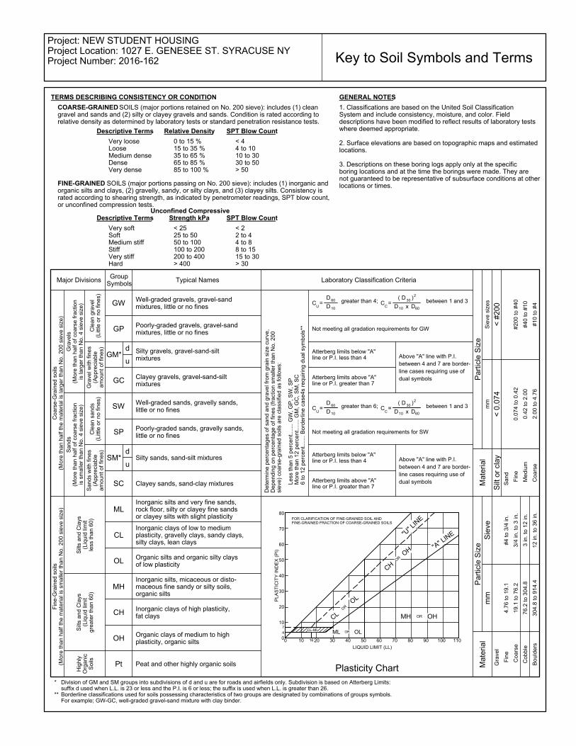
GENERAL NOTESTERMS DESCRIBING CONSISTENCY OR CONDITION
SPT Blow CountDescriptive Terms
< 22 to 44 to 88 to 1515 to 30> 30
< 2525 to 5050 to 100100 to 200200 to 400> 400
Very softSoftMedium stiffStiffVery stiffHard
Unconfined CompressiveStrength kPa
Relative Density SPT Blow CountDescriptive Terms
0 to 15 %15 to 35 %35 to 65 %65 to 85 %85 to 100 %
Very looseLooseMedium denseDenseVery dense
1. Classifications are based on the United Soil ClassificationSystem and include consistency, moisture, and color. Fielddescriptions have been modified to reflect results of laboratory testswhere deemed appropriate.
2. Surface elevations are based on topographic maps and estimatedlocations.
3. Descriptions on these boring logs apply only at the specificboring locations and at the time the borings were made. They arenot guaranteed to be representative of subsurface conditions at otherlocations or times.
Key to Soil Symbols and Terms
*
**
0 10 20 30 40 50 60 70 80 90 100 1100
10
20
30
40
50
60
70
80
Plasticity Chart
FOR CLARIFICATION OF FINE-GRAINED SOIL ANDFINE-GRAINED FRACTION OF COARSE-GRAINED SOILS
LIQUID LIMIT (LL)
16
4
7
PLA
ST
ICIT
Y I
ND
EX
(P
I)
between 1 and 3greater than 4;
10D x D60
D30
( )2
D60
10D
=U
greater than 6; between 1 and 3C =C
C10D x D60
D30
( )2
D60
10D
Part
icle
Siz
e
Gra
ve
l w
ith
fin
es
(Ap
pre
cia
ble
am
ou
nt
of
fin
es)
Part
icle
Siz
e
FINE-GRAINED SOILS (major portions passing on No. 200 sieve): includes (1) inorganic andorganic silts and clays, (2) gravelly, sandy, or silty clays, and (3) clayey silts. Consistency israted according to shearing strength, as indicated by penetrometer readings, SPT blow count,or unconfined compression tests.
GM*
4.7
6 t
o 1
9.1
COARSE-GRAINED SOILS (major portions retained on No. 200 sieve): includes (1) cleangravel and sands and (2) silty or clayey gravels and sands. Condition is rated according torelative density as determined by laboratory tests or standard penetration resistance tests.
OR
ORCL
OL
MH OH
OR
CL-ML
"A" L
INE"U
" LIN
E
CH
OH
ML OLOR

0
5
10
15
20
25
30
35
40
45
50
55
60
65
70
75
80
85
90
95
100
0.0010.010.1110100
PI Cc CuLL PL
GRAIN SIZE DISTRIBUTION
COBBLESGRAVEL
60.5
PE
RC
EN
T F
INE
R B
Y W
EIG
HT
SAND
GRAIN SIZE IN MILLIMETERS
coarse fine
ClassificationSpecimen Identification
Specimen Identification D30 D10 %Gravel
coarseSILT OR CLAY
finemedium
%Sand %Silt %Clay
8.8 30.7
3 1002
B-1
4 16 301 2006 10 501/2HYDROMETERU.S. SIEVE OPENING IN INCHES U.S. SIEVE NUMBERS
1403 4
20 40
D60
6 601.5 8 143/4 3/8
B-1
D100
12.5
3.0
3.0
CLIENT THE WOODBINE GROUP
PROJECT NUMBER 2016-162
PROJECT NAME NEW STUDENT HOUSING
PROJECT LOCATION 1027 E. GENESEE ST. SYRACUSE NY
GR
AIN
SIZ
E -
GIN
T S
TD
US
LA
B.G
DT
- 1
2/1
/16
09
:07
- C
:\P
RO
GR
AM
FIL
ES
(X
86
)\G
INT
\PR
OJE
CT
S\2
01
6-1
62
10
27
EA
ST
GE
NE
SE
EE
ST
RE
ET
.GP
J Kenney Geotechnical Services7246 State Fair BlvdBaldwinsville, N.Y. 13209Telephone: 315-638-2706Fax: 315-638-1544

0
5
10
15
20
25
30
35
40
45
50
55
60
65
70
75
80
85
90
95
100
0.0010.010.1110100
PI Cc CuLL PL
GRAIN SIZE DISTRIBUTION
COBBLESGRAVEL
13.0
PE
RC
EN
T F
INE
R B
Y W
EIG
HT
SAND
GRAIN SIZE IN MILLIMETERS
coarse fine
ClassificationSpecimen Identification
Specimen Identification D30 D10 %Gravel
coarseSILT OR CLAY
finemedium
%Sand %Silt %Clay
0.27 31.3 55.7
3 1002
B-1
4 16 301 2006 10 501/2HYDROMETERU.S. SIEVE OPENING IN INCHES U.S. SIEVE NUMBERS
1403 4
20 40
D60
6 601.5 8 143/4 3/8
2.389
B-1
D100
25
9.0
9.0
CLIENT THE WOODBINE GROUP
PROJECT NUMBER 2016-162
PROJECT NAME NEW STUDENT HOUSING
PROJECT LOCATION 1027 E. GENESEE ST. SYRACUSE NY
GR
AIN
SIZ
E -
GIN
T S
TD
US
LA
B.G
DT
- 1
2/1
/16
09
:07
- C
:\P
RO
GR
AM
FIL
ES
(X
86
)\G
INT
\PR
OJE
CT
S\2
01
6-1
62
10
27
EA
ST
GE
NE
SE
EE
ST
RE
ET
.GP
J Kenney Geotechnical Services7246 State Fair BlvdBaldwinsville, N.Y. 13209Telephone: 315-638-2706Fax: 315-638-1544
0
5
10
15
20
25
30
35
40
45
50
55
60
65
70
75
80
85
90
95
100
0.0010.010.1110100
PI Cc CuLL PL
GRAIN SIZE DISTRIBUTION
COBBLESGRAVEL
50.1
PE
RC
EN
T F
INE
R B
Y W
EIG
HT
SAND
GRAIN SIZE IN MILLIMETERS
coarse fine
ClassificationSpecimen Identification
Specimen Identification D30 D10 %Gravel
coarseSILT OR CLAY
finemedium
%Sand %Silt %Clay
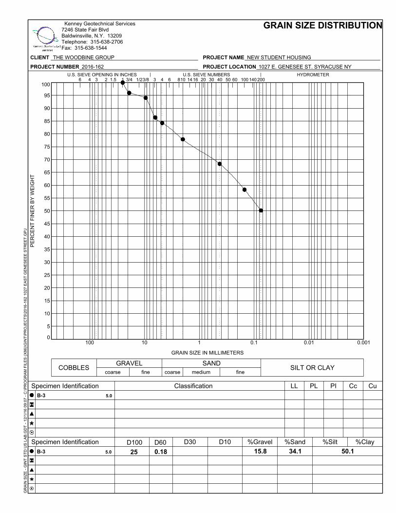
15.8 34.1
3 1002
B-3
4 16 301 2006 10 501/2HYDROMETERU.S. SIEVE OPENING IN INCHES U.S. SIEVE NUMBERS
1403 4
20 40
D60
6 601.5 8 143/4 3/8
0.18
B-3
D100
25
5.0
5.0
CLIENT THE WOODBINE GROUP
PROJECT NUMBER 2016-162
PROJECT NAME NEW STUDENT HOUSING
PROJECT LOCATION 1027 E. GENESEE ST. SYRACUSE NY
GR
AIN
SIZ
E -
GIN
T S
TD
US
LA
B.G
DT
- 1
2/1
/16
09
:07
- C
:\P
RO
GR
AM
FIL
ES
(X
86
)\G
INT
\PR
OJE
CT
S\2
01
6-1
62
10
27
EA
ST
GE
NE
SE
EE
ST
RE
ET
.GP
J Kenney Geotechnical Services7246 State Fair BlvdBaldwinsville, N.Y. 13209Telephone: 315-638-2706Fax: 315-638-1544

0
5
10
15
20
25
30
35
40
45
50
55
60
65
70
75
80
85
90
95
100
0.0010.010.1110100
PI Cc CuLL PL
GRAIN SIZE DISTRIBUTION
COBBLESGRAVEL
20.1
PE
RC
EN
T F
INE
R B
Y W
EIG
HT
SAND
GRAIN SIZE IN MILLIMETERS
coarse fine
ClassificationSpecimen Identification
Specimen Identification D30 D10 %Gravel
coarseSILT OR CLAY
finemedium
%Sand %Silt %Clay
0.285 17.5 62.4
3 1002
B-3
4 16 301 2006 10 501/2HYDROMETERU.S. SIEVE OPENING IN INCHES U.S. SIEVE NUMBERS
1403 4
20 40
D60
6 601.5 8 143/4 3/8
1.643
B-3
D100
19
14.0
14.0
CLIENT THE WOODBINE GROUP
PROJECT NUMBER 2016-162
PROJECT NAME NEW STUDENT HOUSING
PROJECT LOCATION 1027 E. GENESEE ST. SYRACUSE NY
GR
AIN
SIZ
E -
GIN
T S
TD
US
LA
B.G
DT
- 1
2/1
/16
09
:07
- C
:\P
RO
GR
AM
FIL
ES
(X
86
)\G
INT
\PR
OJE
CT
S\2
01
6-1
62
10
27
EA
ST
GE
NE
SE
EE
ST
RE
ET
.GP
J Kenney Geotechnical Services7246 State Fair BlvdBaldwinsville, N.Y. 13209Telephone: 315-638-2706Fax: 315-638-1544

0
5
10
15
20
25
30
35
40
45
50
55
60
65
70
75
80
85
90
95
100
0.0010.010.1110100
PI Cc CuLL PL
GRAIN SIZE DISTRIBUTION
COBBLESGRAVEL
50.5
PE
RC
EN
T F
INE
R B
Y W
EIG
HT
SAND
GRAIN SIZE IN MILLIMETERS
coarse fine
ClassificationSpecimen Identification
Specimen Identification D30 D10 %Gravel
coarseSILT OR CLAY
finemedium
%Sand %Silt %Clay
19.8 29.7
3 1002
B-4
4 16 301 2006 10 501/2HYDROMETERU.S. SIEVE OPENING IN INCHES U.S. SIEVE NUMBERS
1403 4
20 40
D60
6 601.5 8 143/4 3/8
0.24
B-4
D100
19
3.0
3.0
CLIENT THE WOODBINE GROUP
PROJECT NUMBER 2016-162
PROJECT NAME NEW STUDENT HOUSING
PROJECT LOCATION 1027 E. GENESEE ST. SYRACUSE NY
GR
AIN
SIZ
E -
GIN
T S
TD
US
LA
B.G
DT
- 1
2/1
/16
09
:07
- C
:\P
RO
GR
AM
FIL
ES
(X
86
)\G
INT
\PR
OJE
CT
S\2
01
6-1
62
10
27
EA
ST
GE
NE
SE
EE
ST
RE
ET
.GP
J Kenney Geotechnical Services7246 State Fair BlvdBaldwinsville, N.Y. 13209Telephone: 315-638-2706Fax: 315-638-1544

0
5
10
15
20
25
30
35
40
45
50
55
60
65
70
75
80
85
90
95
100
0.0010.010.1110100
PI Cc CuLL PL
GRAIN SIZE DISTRIBUTION
COBBLESGRAVEL
21.5
PE
RC
EN
T F
INE
R B
Y W
EIG
HT
SAND
GRAIN SIZE IN MILLIMETERS
coarse fine
ClassificationSpecimen Identification
Specimen Identification D30 D10 %Gravel
coarseSILT OR CLAY
finemedium
%Sand %Silt %Clay
0.166 38.2 40.2
3 1002
B-7
4 16 301 2006 10 501/2HYDROMETERU.S. SIEVE OPENING IN INCHES U.S. SIEVE NUMBERS
1403 4
20 40
D60
6 601.5 8 143/4 3/8
3.48
B-7
D100
25
3.0
3.0
CLIENT THE WOODBINE GROUP
PROJECT NUMBER 2016-162
PROJECT NAME NEW STUDENT HOUSING
PROJECT LOCATION 1027 E. GENESEE ST. SYRACUSE NY
GR
AIN
SIZ
E -
GIN
T S
TD
US
LA
B.G
DT
- 1
2/1
/16
09
:07
- C
:\P
RO
GR
AM
FIL
ES
(X
86
)\G
INT
\PR
OJE
CT
S\2
01
6-1
62
10
27
EA
ST
GE
NE
SE
EE
ST
RE
ET
.GP
J Kenney Geotechnical Services7246 State Fair BlvdBaldwinsville, N.Y. 13209Telephone: 315-638-2706Fax: 315-638-1544

PROJECT
CLIENT THE WOODBINE GROUP
PROJECT # 2016-162
BORING B-2
DEPTH 23'-25'
DISPLACEMENT PISTON FORCE STRAIN CORRECTED AREA STRESS
INCHES POUNDS IN./IN. SQUARE INCHES PSI
0 0 0.0000 1.49 0.00
0.025 39 0.0081 1.50 25.96
0.05 57 0.0162 1.51 37.64
0.075 77 0.0242 1.53 50.42
0.125 109 0.0404 1.55 70.20
0.15 126 0.0485 1.57 80.46
0.175 139 0.0566 1.58 88.01
0.2 152 0.0647 1.59 95.42
0.25 160 0.0808 1.62 98.70
0.3 160 0.0970 1.65 96.97
0.4 156 0.1293 1.71 91.16
14,213.24 PSFUNCONFINED COMPRESSIVE STRENGTH :
REDVELOPMENT PROJECT 1027 E. GENESEE ST.
UNCONFINED COMPRESSIVE STRENGTH

0.00
20.00
40.00
60.00
80.00
100.00
120.00
0.0000 0.0200 0.0400 0.0600 0.0800 0.1000 0.1200 0.1400
ST
RE
SS
(P
SI)
STRAIN (IN./IN)
UNCONFINED COMPRESSIVE STRENGTH