geotechnical report - amazon web services
TRANSCRIPT

Submitted To:
10451355 Canada Ltd.
141 Main Street, Unit 203
Picton, ON
K0K 2T0
May 15, 2020
AG File No: 19519-1
Final Preliminary Geotechnical
Investigations Report
Talbot on the Trail Subdivision
10451355 Canada Limited
1-50 Grant Timmins Drive
Kingston, Ontario
K7M 8N2
Tel: (343) 266-0002
Fax: (343) 266-0028

Ainley Project No. 19519-1 May 15, 2020 Talbot on the Trail Subdivision Final Preliminary Geotechnical Investigation Report
i
TABLE OF CONTENTS PAGE NO.
1.0 INTRODUCTION .............................................................................................................. 1 2.0 SITE DESCRIPTION ........................................................................................................ 1 3.0 FIELDWORK / METHODOLOGY .................................................................................... 1 4.0 RESULTS OF THE INVESTIGATION ............................................................................. 2
4.1 Sub-Surface Conditions and Laboratory Analysis ........................................... 2 5.0 DISCUSSION AND RECOMMENDATIONS ................................................................... 4
5.2 Slabs-on-Grade ..................................................................................................... 5
5.3 Groundwater Control/Subsurface Drainage ..................................................... 6
5.4 Excavations ........................................................................................................... 6 5.5 Seismic Classification .......................................................................................... 6
5.6 Suitability of Material ............................................................................................ 6 5.7 Utility Trenches ..................................................................................................... 7
5.8 Pavement Design ................................................................................................. 7 5.9 Site Inspections ..................................................................................................... 8
6.0 CLOSURE ........................................................................................................................ 8
Figure No. 1 - Development Preferred Option
Figure No. 1 - Site and Borehole Location Plan
Appendix A - Borehole Logs
Appendix B - Soil Reports

Ainley Project No. 19519-1 May 15, 2020 Talbot on the Trail Subdivision Final Preliminary Geotechnical Investigation Report
Page 1
1.0 INTRODUCTION
Ainley Group (Ainley) was retained by 10451355 Canada Ltd. to carry out geotechnical
consulting services for the proposed Talbot on the Trail Subdivision located in Picton, Ontario.
The objectives of the assignment were:
To conduct a geotechnical site investigation, soil sampling and testing within the subject
site in accordance with the received agreement.
To prepare a geotechnical report and recommendations based on the information
obtained during the geotechnical site investigation completed in order to advance the
preliminary design and construction of the overall project.
Based on the information provided to our office it is understood that the Talbot on the Trail
Subdivision is to consist of the following key components:
1 Single-Detached Homes
55 Front Loaded Townhouses
96 Townhouses (Back-to-Back)
138 Stacked Townhouses
1 Pump Station
All townhouses, back-to-back townhouses, and stacked townhouses are to have an
approximate 7 m x 10 m footprint. Townhouses are based on an underground or half level down
parking approach to avoid large surface parking lots. The subject site with the preferred
development option is demonstrated in Figure No. 1 attached to this report.
2.0 SITE DESCRIPTION
The site is located on Talbot Street, Picton, Ontario. The project area is bound by Talbot Street
to the south, the Millennium Trail and Terra Vista Landscaping to the west, Jasper Avenue
Subdivision to the north and residential lots to the east. The property is approximately 8.6
hectares. The majority of the property is a farm field with a treed area at the back of the lot. The
overall existing site grade is generally sloped towards the north.
3.0 FIELDWORK / METHODOLOGY
The field program consisted of the advancement of a total of eight (8) boreholes throughout the
proposed project area. The boreholes were advanced by means of a track mounted CME-55
drill rig equipped for soil sampling. The boreholes were advanced to depths ranging from 3.0 m
to 7.50 m below existing site grades. The boreholes were advanced on February 18 – 19, 2020
under the constant supervision of a member of Ainley Group’s geotechnical team. Upon

Ainley Project No. 19519-1 May 15, 2020 Talbot on the Trail Subdivision Final Preliminary Geotechnical Investigation Report
Page 2
completion, all borehole locations were reinstated to match existing grade by backfilling with
native soils as required. Prior to commencing the geotechnical investigation program, Ainley
Group contacted local utility companies in order to obtain clearances for all underground
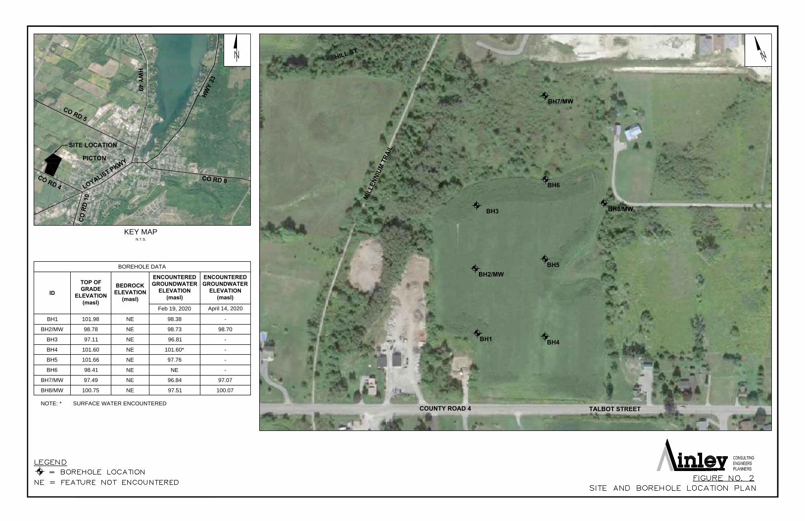
services in the immediate area of the proposed field program. A Site & Borehole Location Plan
is attached to this report as Figure No. 2.
Split spoon sampling procedures were performed at borehole locations to determine the
penetration resistance (in terms of N values, Standard Penetration Index) of the existing
subsoils. The values obtained may be correlated to the relative density of non-cohesive
materials and consistency of cohesive soils. Environmental analysis of the property was not
included within the project scope. Three (3) monitoring wells were installed for the purposes of
measuring groundwater levels.
The location and ground surface elevations at each respective borehole was surveyed using a
Sokkia GSR 2700 ISX GPS with real time sub-centimeter accuracy, and referenced to the UTM
geodetic coordinate system.
4.0 RESULTS OF THE INVESTIGATION
4.1 Sub-Surface Conditions and Laboratory Analysis
Full details of the subsurface conditions encountered at the borehole locations are presented on
the individual borehole logs included in Appendix A. It is emphasized however, that the soil
types, their sequence, thickness and physical properties may vary between borehole locations
and samples both vertically and horizontally.
Representative samples of the subsoil materials encountered within the boreholes were
collected and returned to our office for further visual review by an engineer having experience
with soil classification and identification; however soil samples were not submitted for further
laboratory analysis due to the shallow overburden condition encountered onsite.
The subsoil conditions encountered throughout the site generally consisted of the following:
Topsoil
A surficial layer of silty sand some clay and rootlets topsoil was encountered within all boreholes
advanced within the project. The topsoil thickness ranged between 50 mm to 250 mm.
Silty Sand
Brown silty sand, some clay was encountered beneath the surficial topsoil layer in all boreholes.
This layer extended to depths ranging between 0.80 m and 1.50 m below existing grades and
was found to be in a loose becoming compact state with depth.

Ainley Project No. 19519-1 May 15, 2020 Talbot on the Trail Subdivision Final Preliminary Geotechnical Investigation Report
Page 3
Silt
Brown silt was encountered beneath the silty sand layer in BH3, BH4, BH5 and BH8. This layer
was encountered at depths ranging between 0.80 m to 1.75 m and extended to depths ranging
between 1.50 m and 3.00 m below existing grades. The silt was found to be in a compact state
except in BH4 where it was found to be loose. BH3 was terminated within the silt layer at a
depth of 3.00 m below existing site grades.
Grain size distribution analysis performed on a sample of the silt material obtained from BH8
indicated that the material may be classified as silt with clay and sand having a Medium
Susceptibility to Frost Heave (MSFH). The moisture content was determined to be 16.9% at the
time of the field investigation.
Till
Brown glacial till was encountered beneath the silty sand or silt layer in all boreholes, except
BH3. This layer was encountered at depths ranging between 0.80 m to 2.10 m. All boreholes
where till was encountered were terminated within the dense glacial till deposit at depths
ranging between 4.50 m and 7.50 m below existing grades. The till was found to be compact
becoming dense and grey with depth.
Grain size distribution analysis was performed on four (4) samples of the glacial till obtained
throughout the site. Results indicated that the material may be classified as sand with silt, some
clay, trace of gravel and cobbles having a Low Susceptibility to Frost Heave (LSFH). The
moisture content was determined to range between 8.4% to 9.2% at the time of the field
investigation.
Groundwater
Groundwater infiltration and or surface water was encountered at all borehole locations, except
for BH6, during the borehole investigation. Surface water was encountered at BH4.
Groundwater water encountered at depths (elevations) ranging between 0.05 m – 3.90 m (96.81
m – 101.60 m). Monitoring wells were installed at three (3) boreholes locations for the purpose
of confirming groundwater levels. The monitoring well table below shows monitoring well data
as recorded on February 19, 2020 and April 14, 2020.

Ainley Project No. 19519-1 May 15, 2020 Talbot on the Trail Subdivision Final Preliminary Geotechnical Investigation Report
Page 4
Monitoring Well Location and Data Table
MW/BH ID
Location Grade
Elevation
GW Elevation
Easting Northing 19/02/20 14/04/20
BH2/MW 326938.522 4875039.227 98.78 98.73 98.70
BH7/MW 327117.297 4875164.444 97.49 96.79 97.07
BH8/MW 327107.258 4875039.730 100.75 97.51 100.07
5.0 DISCUSSION AND RECOMMENDATIONS
It is our understanding that the purpose of the geotechnical assignment is to provide
recommendations based on the information obtained during the geotechnical site investigation
completed in order to advance the preliminary design and construction of the subject property.
Based on the site investigation observations, further review and/or investigations may be
necessary once final grading for the development has been established.
5.1 Foundations
Based on the subsoil and groundwater conditions encountered at the test locations and
considering them to be generally representative of the subsoil and groundwater conditions
across the site, the following recommendations and comments are offered to advance the
planning and detail design of the development.
The results of the investigation program revealed that there is one predominate founding layer
across the site suitable for the placement of the proposed foundations; namely the compact to
dense glacial till encountered in all boreholes with exception to BH3. The following
recommendations are offered to advance the detail design of the proposed development:
Conventional strip and spread footings may be designed to bear directly on the compact to
dense glacial till encountered at approximate depths (elevations) ranging from 0.8 m to 1.5 m
(97.61 m to 100.16 m) below existing site grades. The foundations may be designed using the
bearing capacity values of 75 KPa (SLS) or 125 KPa (ULS) with a geotechnical resistance factor
of 0.5.
In the vicinity of BH3, the glacial till layer was not encountered within the depth of the borehole.
For foundations in this vicinity, it is recommended to found on the stiff silt with clay layer
encountered at a depth (elevation) of 1.75 m (95.36 m). The foundations may be designed using
the bearing capacity values of 75 KPa (SLS) or 125 KPa (ULS) with a geotechnical resistance
factor of 0.5.

Ainley Project No. 19519-1 May 15, 2020 Talbot on the Trail Subdivision Final Preliminary Geotechnical Investigation Report
Page 5
Alternatively, foundations may be placed on properly constructed engineered fill built up from
the approved founding surface (till or silt with clay). Engineered fill should consist of granular
material approved by the engineer and compacted to 100% Standard Proctor Maximum Dry
Density (SPMDD). The engineered fill material should be placed in lifts compatible with the
compaction equipment used. A quality control technician should monitor the placement of the
engineered fill material and the compaction densities for each lift to ensure that proper
compaction efforts have been achieved. Foundations placed on properly constructed
engineered fill built up from the approved stiff silty clay bedrock surface may be designed using
the bearing capacity values of 75 kPa (SLS) or 125 kPa (ULS).
The bearing capacities noted are valid provided the footings are placed on undisturbed soils,
free of frost, topsoil and organic materials. Total and differential settlements for foundations
placed on the approved native soil or engineered fill under SLS pressure conditions should not
exceed 25 mm and 19 mm respectively.
All exterior footings for unheated structures must be protected by a minimum of 1.5 m of earth
cover or equivalent, and 1.2 m for heated structures in order to provide protection against
detrimental frost action. Alternatively, using insulation material placed over the concrete
foundation wall and below the slab base course could also be considered.
5.2 Slabs-on-Grade
Assuming the structures will include a basement level, normal slab-on-grade construction can
be carried out as follows:
a) Remove all overburden materials and surficial topsoil to expose the underlying glacial till or
stiff silt with clay.
b) Build up granular fill materials from the approved glacial till or silt with clay surface by
placing Granular ‘B’ Type II material in lifts suitable with the compaction equipment used to
achieve a minimum of 100% SPMDD. A capillary moisture barrier consisting of either 19
mm clear crushed stone or Granular ‘A’ is recommended at least 200 mm thick immediately
underlying the slab. The 200 mm thick Granular ‘A’ is also recommended for fine grading
purposes and to provide a uniform bearing surface for the concrete slab.
Under floor drains are not considered necessary providing the slab is set a minimum of 0.3 m
above finished exterior grades for structures without a basement. Due to the high groundwater
elevations encountered, it is recommended that perimeter and underfloor drains connected to a
suitable sump be provided for footings and basement slabs.

Ainley Project No. 19519-1 May 15, 2020 Talbot on the Trail Subdivision Final Preliminary Geotechnical Investigation Report
Page 6
5.3 Groundwater Control/Subsurface Drainage
Based on the observations made during the field investigation and our knowledge of the local
geologic conditions, significant groundwater infiltrations may be encountered within excavations,
however it should be noted that groundwater levels will fluctuate seasonally and also during
periods of drought and precipitation. Development areas within the site should be graded in the
early stages of construction to provide for positive runoff of all surface water. The pumping of
groundwater will be required during excavation of the shallow overburden. Contractors should
review the groundwater levels at the time of construction to ensure suitable dewatering
operations are in place to keep the groundwater level below the excavation during the
construction period.
5.4 Excavations
All excavations should be carried out in accordance with the provisions in the Occupational
Health and Safety Act. At the time of the field investigations the sub-soil materials encountered
across the site can be classified as follows:
The compact silty sand may be classified as Type 3 soil.
The glacial till and silt with clay may be classified as Type 2 soil.
Shallow excavations into the native soils are considered straightforward and conventional
excavation techniques and equipment appropriate.
5.5 Seismic Classification
Based upon the subsoil information obtained during the field program the proposed
development site may be graded as Site Classification ‘C’ with respect to Table 4.1.8.4.A of the
Ontario Building Code.
5.6 Suitability of Material
The silty sand and glacial till material encountered across the site may be reused for grading
operations outside the building envelope and foundation walls. A maximum particle size of 100
mm is recommended for backfill used against foundation walls. The subsoils are considered
suitable for reuse as subgrade material below exterior paved areas for fill materials throughout
the site to meet grading or in utility trenches.
The silt with clay is not considered suitable for reuse for grading purposes as it has a MSFH.
It is cautioned that the silt and clay content within the soil matrix makes it susceptible to strength
loss and swelling when wet and shrinking of the clay material when dry. It is recommended that
moisture contents in these soils be closely monitored when it is to be used as select subgrade

Ainley Project No. 19519-1 May 15, 2020 Talbot on the Trail Subdivision Final Preliminary Geotechnical Investigation Report
Page 7
fill or as a founding soil during construction. Wet soils should not be placed as backfill,
subgrade fill or utilized as a founding material under any circumstances.
5.7 Utility Trenches
The construction of utility trenches to service the proposed site should consist of removal of the
existing overburden soils to achieve the required grades. Based on the soils information
obtained from the site utility pipes will be installed in soil trenches. Bedding for the pipes should
consist of 150 mm Granular ‘A’ material. The bedding should be placed in lifts compatible with
the compaction equipment used to achieve 100% SPMDD. Backfill around the pipes should
consist of Granular ‘A’ material with a minimum cover thickness of 300 mm over the obvert of
the pipe. The backfill should be compacted to 100% SPMDD.
5.8 Pavement Design
It is recommended that the proposed roadway construction consist of the complete removal of
the existing organic topsoil and any soft, loose or wet materials. The exposed subgrade should
be inspected and approved by geotechnical personnel and any unsuitable materials should be
sub-excavated and replaced with suitable approved fill. The subgrade should be shaped and
crowned to provide suitable lateral drainage.
For areas that require the subgrade to be raised to achieve the proposed profile grade, it is
considered that some of the native material may be used for this purpose subject to approval by
the geotechnical engineer. Alternatively, the fill material should consist of OPSS Select
Subgrade or Granular ‘B’, Type II placed in lifts compatible with the compaction equipment used
to achieve a minimum of 95% SPMDD.
The following pavement structure is considered suitable for this development:
40 mm HL3 Surface Course, over
50 mm HL8 Binder Course, over
150 mm Granular ‘A’, over
300 mm Granular ‘B’, Type II
Granular ‘A’ and ‘B’ used for base and subbase material shall meet the requirements of OPSS
1010 and shall be compacted to 100% SPMDD.
Inspection by qualified geotechnical personnel should be carried out during the construction
process to verify the competence of the subgrade material and to verify the compaction
densities of both the subbase and base course material.
In addition, based on the groundwater levels noted during the investigation, it is highly
recommended that grading operations for the roadway occur at dryer times of the year. It is also

Ainley Project No. 19519-1 May 15, 2020 Talbot on the Trail Subdivision Final Preliminary Geotechnical Investigation Report
Page 8
recommended that a provisional item for geotextile filter cloth and/or additional Granular B, Type
II be considered in the contract should a wet, soft subgrade be encountered.
5.9 Site Inspections
It is recommended that all foundation and subgrade materials be inspected by qualified
geotechnical personnel prior to the placement of concrete for footings, in order to ensure that
the materials and founding elevations are consistent with the recommendations of this report. It
is also recommended that the placement and compaction of all fill soils be monitored and tested
by qualified geotechnical personnel to ensure that the appropriate materials and compaction
densities are achieved.
6.0 CLOSURE
The Limitations of Report attached, form an integral part of this report. We trust this report
provides sufficient information for your present requirements in accordance with our agreement.
We trust this report is to your satisfaction. Should you have any questions concerning the
above, please feel free to contact our office.
Sincerely,
AINLEY GRAHAM & ASSOCIATES LIMITED
Lois-Ann L. Hayes, P.Eng.
Branch Manager

Ainley Project No. 19519-1 May 15, 2020 Talbot on the Trail Subdivision Final Preliminary Geotechnical Investigation Report
Limitations of Report
The conclusions and recommendations given in this report are based on information determined
at the borehole locations. Subsurface and groundwater conditions between and beyond the test
holes may differ from those encountered at the test locations, and conditions may become
apparent during construction, which could not be detected or anticipated at the time of the site
investigation. It is recommended practice that the Soils Engineer be retained during
construction to confirm that the subsurface conditions throughout the site do not deviate
materially from those encountered in the boreholes.
The comments made in this report are intended only for the guidance of the designer. The
number of test holes may not be sufficient to determine all factors that may affect construction
methods and costs. The contractors bidding on this project or undertaking the construction
should therefore make their own interpretation of the factual information presented and draw
their own conclusions as to how the subsurface conditions may affect their work.
This report has been prepared for design purposes, for the sole use of 10451355 Canada Ltd.
Any uses, which a Third Party makes of this report, or any reliance or decisions to be made
based on it, are the responsibilities of said Third Parties. Ainley Group accepts no responsibility
for damages if any, suffered by any Third Party as a result of decisions made or actions based
on this report.

Ainley Project No. 19519-1 May 15, 2020 Talbot on the Trail Subdivision Final Preliminary Geotechnical Investigation Report
Figure No.1
Development Preferred Option

SITE INFORMATION
ZONINGC4-H(T1)
SITE AREATotal Site Area = 1,521m2
PARKING RATESResidential = 1.0 p/unitRetail = 1.0 p/28m2
REQUIRED SETBACKSFront YardSide YardRear Yard
DEVELOPMENT STATISTICS
RESIDENTIAL UNITS Apartment: 30 Assumes an 80% efficiency
GFA Retail 463m2Residential 373m2
PARKINGResidential = 31Retail = 13 Total = 44
AMENITIESRequired 10m2/ x 30 = 299m2/Provided ~425m2/
NOTES1. Assume typical residential floor height of 3.0m. Assume typical retail floor height of 4.5m.
2. For the purpose of this concept, an average of 86m2/ (925sf) unit size is used to calculate approximate total number of units.
3. The base plan (lot lines, existing roads and surrounding areas) is based on the City's Open Data and aerial images. The site area is approximate and all dimensions need to be confirmed by a proper survey.
10m 25m0 5m
A100
DRAWING:
DRAWN BY: BLREVIEWED: UMG
TALBOT ON THE TRAIL
CLIENT:
CLEAVE GROUP
CONCEPT SITE PLAN
PROJECT:
DATE:
2020.01.07
OTTAWA223 McLeod Street
Ottawa ON K2P 0Z8613.730.5709
KINGSTONThe Woolen Mill
6 Cataraqui Street, Suite 108Kingston ON K7K 1Z7
613.542.5454
TORONTO174 Spadina Avenue, Suite 304
Toronto ON M5T 2C2416.789.4530
www.fotenn.com
174 Spadina Ave, Suite 304Toronto, ON M5T 2C2
416.789.4530 www.fotenn.com
TALB
OT
ST
RE
ET STACKED
STACKEDSTACKED
STACKED STA
CK
ED
STA
CK
ED
OPTION 1
DRAWING:
DATE: A101Talbot on the Trail, Picton
Cleave Group
PROJECT:
CLIENT:2020.01.13
OPTION 1(OVERVIEW + ASSUMPTIONS)
• All townhouses, back-to-back townhouse, and stacked townhouses have an approximately 7m x 10m footprint.
• Average lot depth of 30m.
• Road right-of-way of 20m. Condo road right-of-way of 9m. Laneway right-of-way of 9m.
• Passive recreational trail within 15m wetland area setback.
• Storm water directed to storm water management pond in subdivision to the north.
• Architectural features on select townhouses used to emphasize gateways and prominent intersections.
• The estimated development yeild is as follows:
Single-Detached 11 units
Townhouses 40 units
Townhouses (back-to-back) 96 units
Stacked Townhouses 96 units
Total 243 units
Density 28.4 units/ha11.5 units/ac
Note: Back-to-back townhouses are based on an underground or half level down parking approach to avoid large surface parking lots dominating the community.
Note: Density based off total site area of 8.56ha (21.15ac)
MILLENIUM TRAIL

Ainley Project No. 19519-1 May 15, 2020 Talbot on the Trail Subdivision Final Preliminary Geotechnical Investigation Report
Figure No.2
Proposed Site and Borehole Location Plan
BOREHOLE DATA
ID
TOP OF
GRADE
ELEVATION
(masl)
BEDROCK
ELEVATION
(masl)
ENCOUNTERED
GROUNDWATER
ELEVATION
(masl)
ENCOUNTERED
GROUNDWATER
ELEVATION
(masl)
Feb 19, 2020 April 14, 2020
BH1 101.98 NE 98.38 -
BH2/MW 98.78 NE 98.73 98.70
BH3 97.11 NE 96.81 -
BH4 101.60 NE 101.60* -
BH5 101.66 NE 97.76 -
BH6 98.41 NE NE -
BH7/MW 97.49 NE 96.84 97.07
BH8/MW 100.75 NE 97.51 100.07
NOTE: * SURFACE WATER ENCOUNTERED
KEY MAP
N.T.S.
SITE LOCATION
PICTON
H
W
Y
3
3
H
IL
L
S
T
HW
Y 49
C
O
R
D
5
C
O
R
D
4
C
O
R
D
8
C
O
R
D
1
0
L
O
Y
A
L
I
S
T
P
K
W
Y
BH1
BH2/MW
BH3
BH6
BH8/MW
BH5
BH4
BH7/MW
M
I
L
L
E
N
N
I
U
M
T
R
A
I
L
TALBOT STREET
COUNTY ROAD 4

Ainley Project No. 19519-1 May 15, 2020 Talbot on the Trail Subdivision Final Preliminary Geotechnical Investigation Report
Appendix A
Borehole Logs

Log of Borehole: AG Project No.: 19519-1
Project: Talbot on the Trail
Client: 10451355 Canada Ltd.
Location: Picton, Ontario
Ground Elevation (masl):
Water Elevation (masl):
Depth to Water (m):
Drilled By: G.E.T Drilling Ltd.
Drill Method: Track Mounted CME 55
Drill Date:
Project Engineer: L.A. Hayes, P.Eng
Project Technician: Joshua Charlton, C.Tech
Sheet: 1 of 1
Ainley Group1-50 Grant Timmins DriveKingston, OntarioK7M 8N2
SUBSURFACE PROFILE SAMPLE
Dep
th
0 0ft m
2
2
4
4
6
6
8
10
12
14
16
18
20
Ele
vatio
n
Description
Num
ber
Typ
e
Rec
over
y
SP
T
SPT Graph
Gro
undw
ater
Symbol Log
BH1
101.98
98.38
3.60
0.00
0.25
1.00
4.50
Ground Surface
TopsoilSilty sand, some clay and rootelts, brown, frozen.
Silty SandSilty sand, some clay, loose becoming compact, brown.
TillSand with silt, some clay, trace of gravel, compact becoming dense and wet, brown.
End of Borehole at 4.50 m belowexisting site grades.Note: Groundwater infiltration was encountered at 3.60 m during the borehole investigation.
JC022
JC023
JC024
100
100
88
30
43
50
10 20 30 40
February 18 - 19, 2020
50+
Log of Borehole: AG Project No.: 19519-1
Project: Talbot on the Trail
Client: 10451355 Canada Ltd.
Location: Picton, Ontario
Ground Elevation (masl):
Water Elevation (masl):
Depth to Water (m):
Drilled By: G.E.T Drilling Ltd.
Drill Method: Track Mounted CME 55
Drill Date:
Project Engineer: L.A. Hayes, P.Eng
Project Technician: Joshua Charlton, C.Tech
Sheet: 1 of 1
Ainley Group1-50 Grant Timmins DriveKingston, OntarioK7M 8N2
SUBSURFACE PROFILE SAMPLE
Dep
th
0 0ft m
2
2
4
4
6
6
8
10
12
14
16
18
20
Ele
vatio
n
Description
Num
ber
Typ
e
Rec
over
y
SP
T
SPT Graph
Gro
undw
ater
Symbol Log
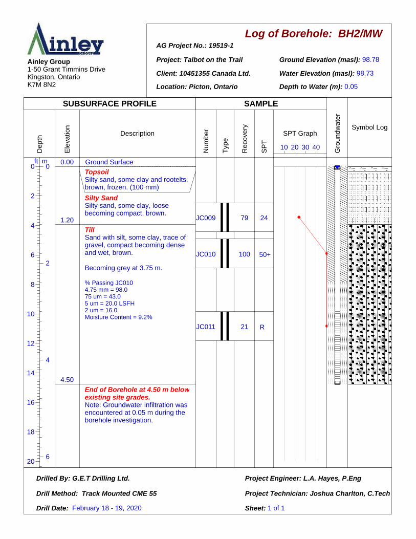
BH2/MW
98.78
98.73
0.05
0.00
1.20
4.50
Ground Surface
TopsoilSilty sand, some clay and rootelts, brown, frozen. (100 mm)
Silty SandSilty sand, some clay, loose becoming compact, brown.
TillSand with silt, some clay, trace of gravel, compact becoming dense and wet, brown.
Becoming grey at 3.75 m.
% Passing JC0104.75 mm = 98.075 um = 43.05 um = 20.0 LSFH2 um = 16.0Moisture Content = 9.2%
End of Borehole at 4.50 m belowexisting site grades.Note: Groundwater infiltration was encountered at 0.05 m during the borehole investigation.
JC009
JC010
JC011
79
100
21
24
50
50
10 20 30 40
February 18 - 19, 2020
50+
R

Log of Borehole: AG Project No.: 19519-1
Project: Talbot on the Trail
Client: 10451355 Canada Ltd.
Location: Picton, Ontario
Ground Elevation (masl):
Water Elevation (masl):
Depth to Water (m):
Drilled By: G.E.T Drilling Ltd.
Drill Method: Track Mounted CME 55
Drill Date:
Project Engineer: L.A. Hayes, P.Eng
Project Technician: Joshua Charlton, C.Tech
Sheet: 1 of 1
Ainley Group1-50 Grant Timmins DriveKingston, OntarioK7M 8N2
SUBSURFACE PROFILE SAMPLE
Dep
th
0 0ft m
2
2
4
4
6
6
8
10
12
14
16
18
20
Ele
vatio
n
Description
Num
ber
Typ
e
Rec
over
y
SP
T
SPT Graph
Gro
undw
ater
Symbol Log
BH3
97.11
96.81
0.30
0.00
1.75
3.00
Ground Surface
TopsoilSilty sand, some clay and rootelts, brown, frozen. (125 mm)
Silty SandSilty sand, some clay, loose becoming compact, brown.
SiltSilt,with clay and sand, stiff, brown, wet.
End of Borehole at 3.00 m belowexisting site grades.Note: Groundwater infiltration was encountered at 0.30 m during the borehole investigation.
JC012
JC013
JC014
100
100
100
10
27
21
10 20 30 40
February 18 - 19, 2020

Log of Borehole: AG Project No.: 19519-1
Project: Talbot on the Trail
Client: 10451355 Canada Ltd.
Location: Picton, Ontario
Ground Elevation (masl):
Water Elevation (masl):
Depth to Water (m):
Drilled By: G.E.T Drilling Ltd.
Drill Method: Track Mounted CME 55
Drill Date:
Project Engineer: L.A. Hayes, P.Eng
Project Technician: Joshua Charlton, C.Tech
Sheet: 1 of 1
Ainley Group1-50 Grant Timmins DriveKingston, OntarioK7M 8N2
SUBSURFACE PROFILE SAMPLE
Dep
th
0 0ft m
2
2
4
4
6
6
8
10
12
14
16
18
20
Ele
vatio
n
Description
Num
ber
Typ
e
Rec
over
y
SP
T
SPT Graph
Gro
undw
ater
Symbol Log
BH4
101.60
101.60
Surface
0.00
0.80
1.50
4.50
Ground Surface
TopsoilSilty sand, some clay and rootelts, brown, frozen. (50 mm)
Silty SandSilty sand, some clay, loose, wet, brown.
SiltSilt with clay and sand, loose, brown.
TillSand with silt, some clay, trace of gravel and cobbles, compact becoming dense and wet, brown.
Becoming grey at 3.30 m.
% Passing JC0264.75 mm = 98.075 um = 37.05 um = 20.0 LSFH2 um = 16.0Moisture Content = 8.6%
End of Borehole at 4.50 m belowexisting site grades.Note: Surface water was encountered during the borehole investigation.
JC025
JC026
JC027
JC028
100
83
100
17
8
40
33
50
10 20 30 40
February 18 - 19, 2020
R

Log of Borehole: AG Project No.: 19519-1
Project: Talbot on the Trail
Client: 10451355 Canada Ltd.
Location: Picton, Ontario
Ground Elevation (masl):
Water Elevation (masl):
Depth to Water (m):
Drilled By: G.E.T Drilling Ltd.
Drill Method: Track Mounted CME 55
Drill Date:
Project Engineer: L.A. Hayes, P.Eng
Project Technician: Joshua Charlton, C.Tech
Sheet: 1 of 1
Ainley Group1-50 Grant Timmins DriveKingston, OntarioK7M 8N2
SUBSURFACE PROFILE SAMPLE
Dep
th
0 0ft m
2
2
4
4
6
6
8
10
12
14
16
18
20
22
Ele
vatio
n
Description
Num
ber
Typ
e
Rec
over
y
SP
T
SPT Graph
Gro
undw
ater
Symbol Log
BH5
101.66
97.76
3.90
0.00
1.00
1.50
6.00
Ground Surface
TopsoilSilty sand, some clay and rootelts, brown, frozen. (75 mm)
Silty SandSilty sand, some clay, loose becoming compact, brown.
SiltSilt with clay and sand, compact, brown.
TillSand with silt, some clay, trace of gravel, compact becoming dense and wet, brown.
Becoming grey at 5.1 m.
End of Borehole at 6.00 m belowexisting site grades.Note: Groundwater infiltration was encountered at 3.90 m during the borehole investigation.
JC018
JC019
JC020
JC021
100
88
96
30
27
34
50
50
10 20 30 40
February 18 - 19, 2020
50+
50+

Log of Borehole: AG Project No.: 19519-1
Project: Talbot on the Trail
Client: 10451355 Canada Ltd.
Location: Picton, Ontario
Ground Elevation (masl):
Water Elevation (masl):
Depth to Water (m):
Drilled By: G.E.T Drilling Ltd.
Drill Method: Track Mounted CME 55
Drill Date:
Project Engineer: L.A. Hayes, P.Eng
Project Technician: Joshua Charlton, C.Tech
Sheet: 1 of 1
Ainley Group1-50 Grant Timmins DriveKingston, OntarioK7M 8N2
SUBSURFACE PROFILE SAMPLE
Dep
th
0 0ft m
2
2
4
4
6
8
10
12
14
16
18
Ele
vatio
n
Description
Num
ber
Typ
e
Rec
over
y
SP
T
SPT Graph
Gro
undw
ater
Symbol Log
BH6
98.41
NA
NA
0.000.15
0.80
4.50
Ground Surface
TopsoilSilty sand, some clay and rootelts, brown, frozen. (150 mm)
Silty SandSilty sand, some clay, loose becoming compact, brown.
TillSand with silt, some clay, trace of gravel, compact becoming dense and wet, brown.
Becoming grey at 2.7 m
% Passing JC0154.75 mm = 97.075 um = 37.05 um = 17.0 LSFH2 um = 14.0Moisture Content = 8.4%.
End of Borehole at 4.50 m belowexisting site grades.Note: Groundwater infiltration was not encountered during the borehole investigation.
JC015
JC016
JC017
100
79
38
43
50
50
10 20 30 40
February 18 - 19, 2020
50+
50+

Log of Borehole: AG Project No.: 19519-1
Project: Talbot on the Trail
Client: 10451355 Canada Ltd.
Location: Picton, Ontario
Ground Elevation (masl):
Water Elevation (masl):
Depth to Water (m):
Drilled By: G.E.T Drilling Ltd.
Drill Method: Track Mounted CME 55
Drill Date:
Project Engineer: L.A. Hayes, P.Eng
Project Technician: Joshua Charlton, C.Tech
Sheet: 1 of 1
Ainley Group1-50 Grant Timmins DriveKingston, OntarioK7M 8N2
SUBSURFACE PROFILE SAMPLE
Dep
th
0 0ft m
2
2
4
4
6
6
8
8
10
12
14
16
18
20
22
24
26
28
Ele
vatio
n
Description
Num
ber
Typ
e
Rec
over
y
SP
T
SPT Graph
Gro
undw
ater
Symbol Log
BH7/MW
97.49
96.84
0.65
0.00
1.50
7.50
Ground Surface
TopsoilSilty sand, some clay and rootelts, brown, frozen. (200 mm)
Silty SandSilty sand, some clay, loose becoming compact, wet, brown.
TillSand with silt, some clay, trace of gravel, compact becoming dense and wet, brown.
Becoming grey at 3.9 m.
% Passing JC0044.75 mm = 98.075 um = 34.05 um = 16.0 LSFH2 um = 13.0Moisture Content = 8.7%
End of Borehole at 7.50 m belowexisting site grades.Note: Groundwater infiltration was encountered at 0.65 m during the borehole investigation.
JC001
JC002
JC003
JC004
-
83
71
21
25
25
22
50
50
50
50
10 20 30 40
February 18 - 19, 2020
50+
50+
50+

Log of Borehole: AG Project No.: 19519-1
Project: Talbot on the Trail
Client: 10451355 Canada Ltd.
Location: Picton, Ontario
Ground Elevation (masl):
Water Elevation (masl):
Depth to Water (m):
Drilled By: G.E.T Drilling Ltd.
Drill Method: Track Mounted CME 55
Drill Date:
Project Engineer: L.A. Hayes, P.Eng
Project Technician: Joshua Charlton, C.Tech
Sheet: 1 of 1
Ainley Group1-50 Grant Timmins DriveKingston, OntarioK7M 8N2
SUBSURFACE PROFILE SAMPLE
Dep
th
0 0ft m
2
2
4
4
6
6
8
10
12
14
16
18
20
22
Ele
vatio
n
Description
Num
ber
Typ
e
Rec
over
y
SP
T
SPT Graph
Gro
undw
ater
Symbol Log
BH8/MW
100.75
97.51
3.24
0.00
1.20
2.10
6.00
Ground Surface
TopsoilSilty sand, some clay and rootelts, brown, frozen. (150 mm)
Silty SandSilty sand, some clay, loose becoming compact, brown.
SiltSilt with clay and sand, compact, brown.% Passing JC0064.75 mm = 100.075 um = 80.05 um = 33.0 MSFH2 um = 22.0Moisture Content = 16.9%
TillSand with silt, some clay, trace of gravel, compact becoming dense and wet, brown.
Becoming grey at 3.6 m.
End of Borehole at 6.00 m belowexisting site grades.Note: Groundwater infiltration was encountered at 3.24 m during the borehole investigation.
JC005
JC006
JC007
JC008
92
100
21
25
15
42
50
50
10 20 30 40
February 18 - 19, 2020
50+
50+

Ainley Project No. 19519-1 May 15, 2020 Talbot on the Trail Subdivision Final Preliminary Geotechnical Investigation Report
Appendix B
Soil Reports

•)) SNC • LAVALIN
Lab# 19748 Client Ainley
Project Name: 19519-1 Talbot on the Trail Date: February 1972020
MASS OF MASS OF MASS OF MASS OF MASS OF MOISTURE
SAMPLE SAMPLE SAMPLE INFORMATION
SAMPLE WET& DRY&
WATER DRY SOIL TARE CONTENT
TARE fg\ TARE le:) (g) (g) (g) (%)
JCOlO A 618.3 573.4 44.9 486.3 87.1 9.2JC026 B 556.3 518.9 37.4 435.8 83.1 8.6JC015 C 460.4 430.4 30 358.5 71.9 8.4JC004 D 486.2 453.4 32.8 379.1 74.3 8.7JC006 E 453.6 400.2 53.4 315.1 85.1 16.9

W?�
CLAY & SILT
GRAIN SIZE IN MICROMETERS 4µm
100 2µm 3µm Sµm 10µm
90
80
70
60
f- so
40
SNC-LAVALIN
UNIFIED SOIL CLASSIFICATION SYSTEM
SAND
Fine Medium Coarse
SIEVE DESIGNATION {Metric)
30µm 40µm 75µm 1SOµm 300µm 600µm 1.18mm 2.36mm
20µm 53µm 106µm
/ ,
J
/ __ ,
1" � ...
'I'
2SOµm 42Sµm 8SOµm 2.0mm 4.75mm
--.-
J
)'
GRAVEL
Fine Coarse
13.2mm 26.5mm 53.0mm 75.0mm 9.5mm 19.0mm 37.5mm 63mm
'
30
-�.,..
SAMPLE DATA _ ... ... �
20 Job : 20-1690-01 � ... Lab No : 19748-A
Borehole : 2 10 Depth : 1.5-2.1m
Sample : JC010
0 <,V
1 2 3 4 s 10 20 30 40 270 200 140
100 60 so 40 30 20 16 10 8 4 3/8" 1/2" 3/4" 1" 1.5" 2" 3"
SIEVE DESIGNATION {Imperial)
% +3" % Gravel %Sand % Fines
Course I Fine Course Medium I Fine Silt I Clay
0 I 2 2 7 I 46 27 I 16
Client: Ainley
SNC-LAVALIN Project: 20-1690-01 1164 Clyde Court Kingston, Ontario K7P 2E4 19519-1 Talbot on the Trail
GRAIN SIZE DISTRIBUTION
SAND
With Silt, Some Clay,Trace Gravel Date: February 17,2020 I Moisture Content is 9.2%

��
CLAY & SILT
GRAIN SIZE IN MICROMETERS 4µm
100 2µm 3µm Sµm 10µm
90
80
70
'-" 60 z
f- 50 z w
w
40
SNC-LAVALIN
UNIFIED SOIL CLASSIFICATION SYSTEM
Fine
30µm 40µm 75µm 150µm
20µm 53µm 106µm
300µm
250µm
SAND
Medium Coarse
SIEVE DESIGNATION (Metric) 600µm 1.18mm 2.36mm
425µm 850µm 2.0mm 4.75mm
--..-
V
/ I
I I
I/ J
/
/.,,.
GRAVEL
Fine Coarse
13.2mm 26.5mm 53.0mm 75.0mm
9.5mm 19.0mm 37.5mm 63mm
30
..,, SAMPLE DATA
_ ... .. -20 Job : 20-1690-01
c.. .... Lab No : 19748-B Borehole :4
10 Depth : 1.5-2.1m Sample : JC026
0 "'"
1 2 3 4 5 10 20 30 40 270 200 140
100 60 50 40 30 20 16 10 8 4 3/8" 1/2" 3/4" 1" 1.5" 2" 3"
SIEVE DESIGNATION (Imperial)
% +3" % Gravel %Sand % Fines
Course I Fine Course I Medium I Fine Silt I Clav
0 I 2 2 I 10 I 49 21 I 16
Client: Ainley
SNC-LAVALIN Project: 20-1690-01
1164 Clyde Court Kingston, Ontario K7P 2E4 19519-1 Talbot on the Trail
GRAIN SIZE DISTRIBUTION
SAND
With Silt, Some Clay,Trace Gravel Date: February 17,2020 I Moisture Content is 8.6%

I
100
90
80
70
(.'.) 60 z
f- 50 z
a'.
40
30
20
10
0
CLAY & SILT
GRAIN SIZE IN MICROMETERS 4µm
- --
-· -
I··· -
· �--
,-- --
-···-----
2µm 3µm
- ---- ,_ ---·
---·---
·-
i--- ·- --"-
-�
---
-- --I-
- "' - - -���I=""""-"'"' -
·--
1 2 3 4
5µm 10µm
-· -"·-
--�-- , - ----
--- --f--
1-- --f-- -
f----
-- -·-
c�i,, .�
•"""p-
1---- -----
5 10
SNC-LAVALIN
UNIFIED SOIL CLASSIFICATION SYSTEM
SAND GRAVEL
Fine Medium Coarse Fine Coarse
SIEVE DESIGNATION (Metric)
30µm 40µm 75µm 150µm 300µm 600µm 1.18mm 2.36mm 13.2mm 26.5mm 53.0mm 75.0mm
20µm 53µm 106µm 250µm 425µm 850µm 2.0mm 4.75mm
---
9.5mm 19.0mm 37.5mm 63mm
· -- -�-- 1--
I'v
-- f--·
-- ---
- ---- -
--
�-1--·
v
- ·-
20
·-1-f-- f---
-�---
1--l---·-1--
i7�
--�
�
�-
··-
- -
-�
- ----
--
--
- --
�-
I -
-----
I/ � --
- f-
/--
---
- -
�-- f----
·- ·-i---
- -
---
30 40 270 200 140
100 60 50 40
- -- ·--------- ---- - _,,_ --�
- -- - ---· --� -----
- -- ------ �- - -- --- ----
--
-----1-------f--- ----� ·-�--
·-- ---------- . -1----------
------1 ------- -------- -
SAMPLE DATA
-� f--------� r--- ----- . Job : 20-1690-01 Lab No : 19748-C
Borehole :6 -- Depth : 0.75-1.35m
-- I------ - Sample : JC015
,v
31) 20 16 10 B 4 3/8" 1/2" 3/4" 1" 1.5" 2"
SIEVE DESIGNATION (Imperial)
i---
---
-
3"
o/o +3 11 % Gravel %Sand % Fines Course I Fine Course I Medium I Fine Silt I Clav
0 I 3 2 I 7 I 51 23 I 14
Client: Ainley
SNC-LAVALIN Project: 20-1690-01 ·1164 Clyde Court Kingston, Ontario K?P 2E4 19519-1 Talbot on the Trail
GRAIN SIZE DISTRIBUTION
SAND
With Silt, Some Clay,Trace Gravel Date: February 17 ,2020 I Moisture Content is 8.4%

I
SNC-LAVALIN
UNIFIED SOIL CLASSIFICATION SYSTEM
SAND GRAVEL CLAY & SILT
Fine Medium Coarse Fine Coarse
GRAIN SIZE IN MICROMETERS SIEVE DESIGNATION (Metric)
100
90
80
70
(9 60 z
CL f--- 50 z w
w
40
30
20
10
0
4µm 2µm 3µm
· -----------� ----
---
· - -
- -
--
--
, _ _ -
�-
---I-
---- ---
--
-
- --
-
-
--
,_
-�--1-
1 2
I
- ---- , -f---
� -- --
- -- -
-
-·-·-
, -
-- -
3 4
30µm 40µm 75µm 150µm 300µm 600µm 1.18mm 2.36mm 13.2mm 26.5mm 53.0mm 75.0mm
5µm 10µm 20µm 53µm 106µm 250µm 425µm 850µm 2.0mm 4.75mm 9.5mm 19.0mm 37.5mm 63mm
-- -�- --
/ --
--� - --
�� -- -- --,_ ---- -- --- ----
-- -- -------I- -----
--- __ ,_ ----�
7 � - -- - ----- ---1- �- ---·- --,- -
----�--- �-, __
I --� ---- -� -----
--
- -;-
-· --· I/ -- � - --- - - ---- 1--- ---- --- ------ --
-/ -f----- __ ,_ f--f--- -- --- --- -- � ---- � ----
- --f--- �- ---
I --1-f--f--- - --- -- --
---- -- -- - - - _,_ � .1
"' _,..,�
- - -� --;;
>---- � -- -- ----- ---1---------
� --- -----
� e- � ""- ·--- -- - -- ------r--- -- ---- SAMPLE DATA
--· Job : 20-1690-01 -----·-- --- -
-"' lab No : 19748-D -----,- --I--·-- f----- - ,--f------- 1------ ---
- Borehole :7-- Depth : 4.5-5.1m
-�,- Sample : JC004
<,v
5 10 20 30 40 270 200 140
100 60 50 40 30 20 16 10 8 4 3/8" 1/2" 3/4" 1" 1.5" 2" 3"
SIEVE DESIGNATION (Imperial)
% Gravel I % Sand % Fines % +3
n
I Course I Fine I Course I Medium I Fine Silt I I 0 I 2 I 2 I 8 I 55 21 I
Client: Ainley
SNC-LAVALIN Project: 20-1690-01 1164 Clyde Court Kingston, Ontario K7P 2E4 19519-1 Talbot on the Trail
Clay
13
GRAIN SIZE DISTRIBUTION
SAND
With Silt, Some Clay,Trace Gravel Date: February 17 ,2020 I Moisture Content is 8.7%

�??-
CLAY & SILT
GRAIN SIZE IN MICROMETERS 4µm
100 2µm 3µm 5µm 10µm
90
80
70
SNC-LAVALIN
UNIFIED SOIL CLASSIFICATION SYSTEM
Fine
30µm 40µm 75µm 150µm
20µm 53µm 106µm
300µm
250µm
SAND
Medium Coarse
SIEVE DESIGNATION (Metric) 600µm 1.18mm 2.36mm
425µm 850µm 2.0mm 4.75mm
.J> �-
/ V
/ ,,,,.
}"
y /
GRAVEL
Fine Coarse
13.2mm 26.5mm 53.0mm 75.0mm 9.5mm 19.0mm 37.5mm 63mm
60 CD
.,,/ z
/a..
50 z
I a..
40
,,, 30
i.;11" SAMPLE DATA --
..... 20 Job : 20-1690-01
Lab No : 19748-E Borehole : 8
10 Depth : 1.5-2.1m Sample : JC006
0 .. ,
1 2 3 4 5 10 20 30 40 270 200 140
100 60 50 40 30 20 16 10 8 4 3/8" 1/2" 3/4" 1" 1.5" 2" 3"
SIEVE DESIGNATION (Imperial)
% +3" % Gravel %Sand % Fines
Course I Fine Course I Medium I Fine Silt I Clay
0 I 0 0 I 1 I 19 58 I 22
GRAIN SIZE DISTRIBUTION Client: Ainley
SNC-LAVALIN Project: 20-1690-01 1164 Clyde Court Kingston, Ontario K7P 2E4 SILT
With Clay, With Sand
19519-1 Talbot on the Trail
Date: February 17 ,2020 I Moisture Content is 16.9%