geovisualization and synergies with infovis and visual analytics gennady andrienko & natalia...
Post on 19-Dec-2015
237 views
TRANSCRIPT

Geovisualization and synergies with InfoVis and Visual Analytics
Gennady Andrienko & Natalia AndrienkoFraunhofer Institute IAISSankt Augustin Germanyhttp://www.ais.fraunhofer.de/and
Presentation @ Dagstuhl seminar, July 2007

What is geovisualization?
• the use of visual representations of geographic information for the exploration and analysis of the data and gaining understanding of the underlying phenomena
Purposes : • scientific discovery• education• decision support
(some) characteristics of spatial data
• (x,y)-dependent variables non-homogeneous anisotropic continuous (measurements are not error)
• error in: locations (projection, etc.) distances (elevation; constraints; alternatives) attributes (poor models; limited samples) time
• complexities: scale (features / processes scale dependent) characterised by form (key features not at data points) time-dependence
spatial (& temporal) questions we might answer …
• should I carry an umbrella today?• should I harvest my crops tonight?• how is this landscape developing … and what are the implications?• where do we focus our housing improvement grants this year?• can we characterize society spatially to improve services?• what does our audit tell us about the geography of our services?• how do people behave when using our system …
in geographic space? in screen space?
GeoVis is also about time!

What is geovisualization research?
• fundamental research aimed at increasing the understanding of how visual representations facilitate discovery, cognition and understanding of geographically related information and phenomena
• applied research aimed at designing and developing techniques and tools that support this activity in application domains

GeoVis users • perception of space and maps• spatial cognition and reasoning• mental maps • metaphors• trends (wide use of online maps, navigation tools, geobrowsers, geo-wikis, …)
GeoVis of • dynamic phenomena and processes• movement and mobility• complex spatio-temporal structures (plans,scenarios, effects and actions…)• imagery• terrain• non-geographic data
GeoVis for • exploration and analysis• knowledge building and integration• decision making• education and instruction• presentation and communication• collaboration
GeoVis plus • InfoVis, SciVis, statistical graphics, … • multimedia• computational analysis• databases and data warehouses• modelling• spatio-temporal reasoning
GeoVis• Geographic representations• Geographic interfaces• Geographic interactions• GeoVisual Analytics • GeoCollaboration

Example: Analysing Movements

Example: Assessing a Schedule
See @ IEEE VAST 2007
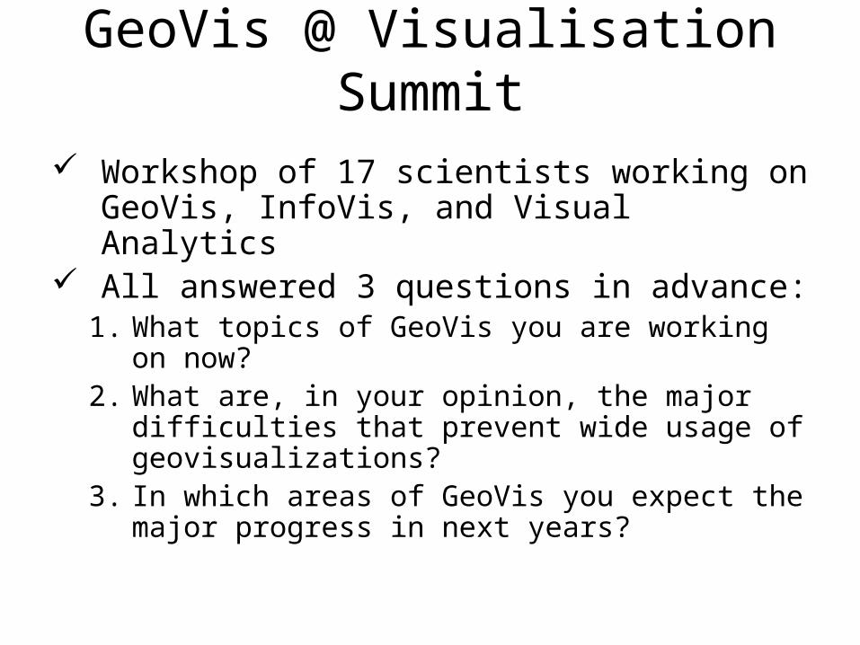
GeoVis @ Visualisation Summit
Workshop of 17 scientists working on GeoVis, InfoVis, and Visual Analytics
All answered 3 questions in advance:1. What topics of GeoVis you are working on
now?2. What are, in your opinion, the major
difficulties that prevent wide usage of geovisualizations?
3. In which areas of GeoVis you expect the major progress in next years?

Data:• dynamic processes• movement• complex structures (plans, scenarios,…)• imagery• terrain
– huge– multivariate– uncertain
Tasks/Purposes:• exploration & analysis• knowledge building• decision making• collaboration• presentation & communication• education & instruction
Technology:• mobile devices• multimedia• multimodal HCI• augmented reality
– Web– GoogleEarth, GoogleMaps,…– SDI– Wiki…
Users:• perception & cognition• mental maps• metaphors• differences (professional, educational, cultural,…)
General
Empirics Practice
Specific
Data
Tasks/Purposes
Technology:• requirements & limitations• opportunities
Users:• requirements• abilities• preferences, habits
Experimental studies
Design principles
CartographyPsychology InfoVis, SciVis…
HCI
StatisticsData MiningDB & DWGeocomputations
Artificial Intelligence
Data Typologies & Models
Patterns & knowledge• typology• representation
GeoVis operators
Instructional sciences (?)
Task Typologies & Models
Inventories of techniques
Models of GeoVis use
Design of generic toolkits & infrastructures
User/task-centred design
MethodologyTheory
• Customisation• Interoperability• Usability
• Evaluation
• Geographic interfaces• Geographic interactions• Collaborative GeoVis• 3D & perspective views• Stereoscopic views• Legend design• GeoVis + multimedia• Visual Analytics• InfoVis interfaces• GeoVis of non-geo data
• Scalability
abc
abc
abc
– much work done and/or many people working– some work done; few people working
– nothing or very little done; none or very few people working
Legend:

Use of GeoVis Problems Undeveloped terminology (e.g. how does GeoVis differ from
cartography?)
Low understanding of additional value of interactivity
Focus on exploration limits users to experts
Tools are designed for expert users too complex!
Poor design and low usability of tools; poor documentation
Tools do not exactly address users’ needs
Ignorance of potential users about the strength of GeoVis
No success stories of solving real-world problems
Lack of education and training in using GeoVis
Low trust of domain specialists in visual approaches; bias towards numbers, formulas, and texts
Lack of support for documenting insights and knowledge gained no material results!
Lack of support for spatial and spatio-temporal reasoning
Lack of ready-to-use softwareo Lack of advanced GeoVis functions in GIS
o Limited functionality of non-commercial tools (focus on particular techniques and data types)
Limited infrastructural (data model) basis
Lack of interoperability of data, systems, and tools/methods
Lack of scalability w.r.t. data size, device characteristics, …
Gap between existing theory and technological opportunities
Widely used: Open online mapping tools GoogleEarth, GoogleMaps, … Weather forecasts Navigation and routing tools GeoVis in geoscientific
community
Not (widely) used: Collaborative GeoVis GeoVis of multivariate data GeoVis of temporal data Visual data mining GeoVis of non-geographic data Generally, advanced GeoVis
tools produced by academics

Challenges• Handle huge volumes of data• Handle complex and heterogeneous information• Handle dynamic phenomena and processes• Support time-critical analysis and decision
making• Support externalisation of insights and synthesis
of knowledge• Increase the use of GeoVis tools, broaden the
user community and application scope• Embrace new hardware and technologies• Develop adequate theory and methodology
InfoVis faces the same challenges !

Common opinion
We need research in multidisciplinary teams (including cartography & GeoVis, InfoVis, data mining, databases, HCI, cognitive sciences)
for solving real-life spatio-temporal problems characterized by huge volumes of complex data
in tight cooperation with domain experts

Where to learn more?
Special issue on “GeoVisual Analytics for Spatial Decision Support”, edited by G.Andrienko, N.Andrienko, P.Jankowski, and A.MacEachrenInt.J.GIScience, 2007, v.21(8)
http://kartoweb.itc.nl/icavis/index.html Next workshop: Helsinki, August 2-3, 2007