german traffic regulations for navigable maritime...
TRANSCRIPT

German Traffic Regulations forNavigable Maritime Waterways
English version of the Seeschiffahrtsstraßen-Ordnung(SeeSchStrO)
The English version of the German Traffic Regulations for Navigable Maritime Waterways (Seeschiff-fahrtsstraßen-Ordnung, SeeSchStrO) is made availalble free of charge by Bundesamt für Seeschifffahrt und Hydrographie (BSH) for the convenience of the shipping industry. As this document is not an of-ficial BSH publication, any kind of warranty is excluded.
It should be noted that this document does not have any legal standing.
The German version published in the Bundesgesetzblatt and the Bundesanzeiger prevails in any case.
© Bundesamt für Seeschifffahrt und Hydrographie (BSH)Hamburg und Rostock 2013www.bsh.de
Updated to November 2015

The contents of this publication are protected by copyright. All rights are reserved, specifically the rights of trans-lation, reprinting, recitation, reuse of illustrations and tables, promulgation, reproduction on microfilm or in any other way, as well as the right of storage, either in whole or in part. Reproduction of this publication or parts of this publication is permitted only under the provisions of German law, also in individual cases.

G e r m a n T r a f f i c R e g u l a t i o n s f o r N a v i g a b l e M a r i t i m e W a t e r w a y s 3
Introduction
Seeschifffahrtsstraßen-Ordnung (SeeSchStrO)(German Traffic Regulations for Navigable Maritime Waterways)
Version promulgated on 22 October 1998 (Federal Law Gazette 1998 I, p. 3209)Last amended by the Ordinance of 20 December 2012 (Federal Law Gazette I p. 2802)
The German Traffic Regulations for Navigable Maritime Waterways (SeeSchStrO) have the following typical features:
a) priority of Collision Regulations,b) absence of local case-by-case regulations,c) equal rights for all participants of traffic (seagoing vessels, inland vessels, small craft) on all navigab-
le waterways,d) coloured representation of lights and shapes to be exhibited, sound signals, prohibition, warning
and information signs, and traffic signals at bridges, locks, and barrages in the annexes to the See-SchStrO
Bekanntmachungen der Außenstellen der Generaldirektion Wasserstraßen und Schifffahrt (GDWS)(Notices of the regional offices of the Federal Waterways and Shipping Agency )
North Western Region Office of 7 October 1998 (BAnz. 203/98 p. 15531)Last amended 18 February 2013 (BAnz. AT 26.02.2013 B7 of 26 February 2013)
Northern Region Office of 28 January 2014 (BAnz. AT 31.01.2014 B7)Last amended 16 July 2015 (BAnz. AT 16.07.2015 B7 of 6 July 2015)
The Notices of the Waterways and Shipping Directorates (WSD Nord and WSD Nordwest) con-cerning the SeeSchStrO provide additional information supplementing the general traffic regula-tions in those cases where the responsible authorities considered more details referring to pro-mulgated supplements necessary because of frequent amendments..
The Notices of the Waterways and Shipping Directorates are shown below the SeeSchStrO para-graphs to which they refer, or on the opposite (right) page. The sequence of sea areas and water-ways is from the North Sea via Kiel Canal to the Baltic Sea. The Notices are emphasized by grey tint.
Bundesamt für Seeschifffahrt und HydrographieHamburg and Rostock
Comment: For the tasks in Sections 55, 60, and 61 for which the former Waterways and Shipping Directorates were explicitly responsible by law, the offices of the Federal Waterways and Shipping Agency remain responsible as legal successors to the Waterways and Shipping Directorates and act in this context under their own responsibility.

4 G e r m a n T r a f f i c R e g u l a t i o n s f o r N a v i g a b l e M a r i t i m e W a t e r w a y s
Noticeto promulgate theTraffic Regulations for Navigable Waterways (Revised)
[“Neufassung der Seeschifffahrtsstraßen-Ordnung”]of 22 October 1998
Traffic Regulations for Navigable Waterways(Seeschifffahrtsstraßen-Ordnung)(SeeSchStrO)
Table of contents
Part OneGeneral provisionsSection 1 Area of application ............................................................................................. 9Section 2 Definitions .......................................................................................................... 10Section 3 Basic rules for conduct in traffic ........................................................................ 26Section 4 Responsibility ..................................................................................................... 27Section 5 Signs and signals for navigational purposes ...................................................... 28Section 6 Visual signs and sound signals of vessels ......................................................... 28Section 7 Vessels in the Public Service .............................................................................. 29
Part TwoVisual signs of and sound signals of vesselsSection 8 General ............................................................................................................... 30Section 9 Use of navigation lights and sound-signalling appliances ................................. 31Section 10 Small vessels ..................................................................................................... 32Section 11 Signals of inland waterway vessels .................................................................... 34Sections 12 through 18 [These Sections have been suspended.]
Part ThreeSound signals of vesselsSections 19 and 20 [These Sections have been suspended.]
Part FourSailing rulesSection 21 Basic principles .................................................................................................. 36Section 22 Exceptions from the requirement to proceed on the starboard side of a fairway ......................................................................................................... 36Section 23 Overtaking .......................................................................................................... 38Section 24 Head-on situations ............................................................................................. 40Section 26 Speed ................................................................................................................. 44Section 27 Towing and pushing ........................................................................................... 48Section 29 Entering and leaving locks ................................................................................. 49Section 30 Bans and restrictions affecting navigation ......................................................... 49
Part FiveStationary trafficSection 32 Anchoring ........................................................................................................... 68Section 33 Berthing and mooring ........................................................................................ 72Section 34 Cargo-handling operations ................................................................................ 73 carrying certain dangerous goods ..................................................................... 76Section 36 Handling of certain dangerous goods ................................................................ 80

G e r m a n T r a f f i c R e g u l a t i o n s f o r N a v i g a b l e M a r i t i m e W a t e r w a y s 5
Part SixMiscellaneous provisionsSection 37 Conduct in the event of a marine casualty and of the loss overboard of objects ........................................................................................................... 83Section 38 Fishing and hunting ............................................................................................ 83Section 39 Sailing schedules of passenger vessels and ferries crossing a river or canal .... 87Section 40 Carriage of document ........................................................................................ 87
Part SevenSupplementary provisions relating to the Kiel CanalSection 41 Area of application ............................................................................................. 88Section 42 Admission for passage ....................................................................................... 88Section 43 Reporting in for, and out from, passage through the Kiel Canal ........................ 91Section 44 [This Section has been suspended.] .................................................................. 92Section 45 Traffic in the approaches to the Kiel Canal ......................................................... 92Section 46 Right-of-way regulations for vessels entering or leaving locks .......................... 93Section 47 Ban on entering respectively leaving locks ........................................................ 93Section 48 Minimum safe distances between vessels ......................................................... 94Section 49 Conduct of vessels in front of, and in, sidings ................................................... 94Section 50 Sailing rules for vessels exempt from compulsory pilotage and for composite units .................................................................................................. 94Section 51 Sailing rules for pleasure craft ............................................................................ 96Section 52 [This Section has been suspended.] .................................................................. 96Section 53 Navigating and mooring on the Gieselaukanal .................................................. 96Section 54 [This Section has been suspended.] .................................................................. 96
Part EightCompetences and responsibilities of the Federal Waterways and Shipping AdministrationSection 55 Shipping police authorities ................................................................................. 97Section 55a Vessel Traffic Services centres (VTS centres) ..................................................... 97Section 56 Shipping police orders ....................................................................................... 97Section 57 Shipping police permits ..................................................................................... 98Section 58 Shipping police reports ...................................................................................... 98Section 59 Exemptions ........................................................................................................ 106Section 60 Authorization to issue shipping police notices and ordinances ......................... 106
Part NineProvisions on administrative fines and on matters of competenceSection 61 Administrative offences ...................................................................................... 107Section 62 (Entry into force; Cancellation and revocation of sundry rules and regulations) ......................................................................................................... 109
Annex ISigns and signals for navigational purposesPreliminary remarks1. Visual signs ........................................................................................................ 1112. Sound signals .................................................................................................... 115

6 G e r m a n T r a f f i c R e g u l a t i o n s f o r N a v i g a b l e M a r i t i m e W a t e r w a y s
Section I – Visual signs
A Requirement signs and prohibition signsA. 1 Prohibition to overtake ....................................................................................... 116A. 2 Prohibition to meet approaching vessel at narrow passage .............................. 116A. 3 Speed limit ......................................................................................................... 116A. 4 Speed limit (on account of hazards due to suction or wash) ............................. 116A. 5 Speed limit (when approaching a bathing site) .................................................. 117A. 6 Requirement to keep a minimum safe distance ................................................. 117A. 7 Requirement to stop for clearance in front of a movable bridge, a flood barrier,
or locks .............................................................................................................. 117A. 8 Anchoring ban .................................................................................................... 118A. 9 Mooring ban ....................................................................................................... 118A.10 Lying ban ............................................................................................................ 118A.11 Requirement to proceed in a given direction ..................................................... 118A.12 Requirement to make a sound signal ................................................................. 119A.13 Requirement to stop in locks ............................................................................. 119A.14 Passage beneath bridge .................................................................................... 119A.15 End of stretch of waterway where a requirement or prohibition is effective ...... 119A.16 Requirement to stop .......................................................................................... 119A.17 Waters restricted or closed ................................................................................ 120A.18 Waterway completely or partly closed ............................................................... 121A.19 Passage of movable bridge or flood barrier, entry into/exit from locks, and
entry into/exit from the approaches to locks ..................................................... 122A.20 Entry into the approaches to the Kiel Canal ....................................................... 123A.21 Entry into the by-ports and the locks of the Kiel Canal at Brunsbüttel and
Kiel-Holtenau ..................................................................................................... 123A.22 Passage through a siding (along the Kiel Canal) ................................................ 124A.23 Traffic at the Brunsbüttel Oil Terminal ................................................................ 126A.24 Entry into, and exit from, the Gieselaukanal and the Dead Trave Arm (ie, the
old course of the River Trave at the “Teerhofinsel” Islet) .................................... 126A.25 Entry into the Husumer Au ................................................................................. 127A.26 Entry into the approaches of the Eider Flood Barrier ......................................... 127
B. Warnings and adviceB.1 Ferry crossing .................................................................................................... 127B.2 Passage of solid-built bridge ............................................................................. 127B.3 Telephone ........................................................................................................... 127B.4 Limit of a siding (along the Kiel Canal) ............................................................... 128B.5 Water-skiing ....................................................................................................... 128B.6 Extraordinary obstacle to navigation ................................................................. 128B.7 Transverse current .............................................................................................. 128B.8 Jetbikes .............................................................................................................. 128B.9 Wind-surfing boards .......................................................................................... 128B.10 Access to a fairway/to the centre-line of a shipping route ................................. 129B.11 Fairway limits (lateral marks) .............................................................................. 129B.12 (This Item has been suspended.)B.13 Fairway branching off from, or joining, another fairway ..................................... 131B.14 Roadstead .......................................................................................................... 132B.15 Danger spot ....................................................................................................... 134B.16 Specific area or location .................................................................................... 137B.17 Mooring buoy ..................................................................................................... 139
Section II – Sound signalsC.1 Stop! ................................................................................................................... 140C.2 Prohibition to pass/enter .................................................................................... 140C.3 Permission to pass/enter ................................................................................... 140C.4 Waterway closed ................................................................................................ 140C.5 Entry from sea into the approaches to, or the locks of, the Kiel Canal .............. 141C.6 Entry into the locks of the Kiel Canal from within the Canal .............................. 141

G e r m a n T r a f f i c R e g u l a t i o n s f o r N a v i g a b l e M a r i t i m e W a t e r w a y s 7
Annex II
Visual signs and sound signals of vessels
II.1 Visual signs of vessels
II.2 Sound signals of vessels
Explanatory notes relating to Annex II1 General ............................................................................................................... 1422 General note relating to lights ............................................................................ 1422.1 Note relating to the characteristics of lights ....................................................... 1422.2 Depiction of lights .............................................................................................. 1423. Note relating to sound signals ........................................................................... 143 Depiction of sound signals ................................................................................. 143
II.1 Visual signs of vessels1 Sign to identify a vessel in the Public Service engaged on a shipping police
mission ............................................................................................................... 1442 Sign to identify a vessel of the Federal Customs Administration ....................... 1443 Sign to identify a vessel of the Federal Armed Forces or of the Federal Border
Guard, or a power-driven vessel towing firing-range targets ............................. 1444 [This Item has been suspended.]5.1 Ferry underway and maintaining connecting lines with one or both banks
respectively embankments ................................................................................ 1455.2 Ferry underway on the Kiel Canal, the River Trave, or the River Warnow and
not maintaining connecting lines with one or both banks respectively embank-ments ................................................................................................................. 145
6 Sign to identify a vessel or composite unit carrying certain dangerous goods in terms of Section 2(1)(Item 16) of these Traffic Regulations or an empty vessel in terms of Section 30(1)(Item 3) thereof ........................................................... 145
(on the Kiel Canal also vessels within the description of particulary dangerous vessels and composite units) ............................................................................. 145
7. [This Item has been suspended.]8. [This Item has been suspended.]9. Sign to identify floating apparel used by a vessel engaged in dredging or
underwater operations ....................................................................................... 14610. Sign to identify a vessel restricted in her ability to maoeuvre and engaged in
dredging or underwater operations in a fairway ................................................. 14611 Sign to identify a moored vessel, a floating installation in terms of Section 2(1)
(Item 5) of these Traffic Regulations, or an extraordinary floating object in terms of Section 2(1)(Item 6) thereof .................................................................. 147
11.1 The length of the vessel is less than 50 metres. ................................................ 14711.2 The length of the vessel is 50 metres or more. .................................................. 14711.3 Exceptions and Special Regulations .................................................................. 14712 Sign to identify a vessel navigating on the Kiel Canal with a pilot embarked
(Section 2(1)(Item 18a) and wishing to leave the locks for the Canal ................. 14812.1 Vessel categories 1 and 2 .................................................................................. 14812.2 Vessel category 3 ............................................................................................... 14812.3 Vessel category 4 ............................................................................................... 14812.4 Vessel category 5 ............................................................................................... 14812.5 Vessel category 6 ............................................................................................... 14913 Sign to identify a vessel exempted from compulsory pilotage on the Kiel Canal
in terms of Section 2(1) (Item 15) of these Traffic Regulations ........................... 14913.1 Vessels of category 1 ......................................................................................... 14913.2 Vessels of category 2 ......................................................................................... 15013.3 Vessels of category 3 ......................................................................................... 15013.4 Vessels of category 4 ......................................................................................... 150

8 G e r m a n T r a f f i c R e g u l a t i o n s f o r N a v i g a b l e M a r i t i m e W a t e r w a y s
14 Sign to identify a vessel stuck on the embankment of the Kiel Canal ............... 15115.1 A vessel requesting a sea pilot from the seaward pilot station of one of the sea
pilotage districts for pilotage in the respective district, or from the roads off Bremerhaven for pilotage to the seaward position of the pilot launch or for pilotage to one of the ports situated in, and owned and operated by, the Free Hanseatic City of Bremen proper, or from the roads off Brunsbüttel for pilotage to the seaward position of the pilot launch or into Hamburg. ............................ 151
15.2 A vessel requesting a sea pilot from the pilot vessel in the approach to Rivers Jade and Weser for pilotage into Wilhelmshaven, or from the roads off Bre-merhaven for pilotage to one of the Lower Saxony ports in the Weser Estuary, or from the roads off Brunsbüttel or Kiel-Holtenau for pilotage on the Kiel Canal. ................................................................................................................. 151
16 Sign to identify a vessel wishing to disembark a sea pilot ................................. 151
II.2 Sound signals of vessels1 Beware! .............................................................................................................. 1521.1 On all navigable waterways except for the Kiel Canal, ...................................... 1522 Danger! Warning! ............................................................................................... 1522.1 General danger and warning signal ................................................................... 1522.2 Stay away! .......................................................................................................... 1532.3 Warning signal to mean “am reducing my speed” (signal for use on the Kiel
Canal) ................................................................................................................. 1532.4 Warning signal to mean “have the intention of mooring” (signal for use on the
Kiel Canal) .......................................................................................................... 1533 Sound signals to be used in restricted visibility ................................................. 1543.1 On the Kiel Canal, a vessel other than a ferry, when underway, shall give the
following sound signal when approaching a location marked by the visual sign described under Item B.1 (Annex I): ................................................................... 154
3.2 Power-driven vessel underway and being towed or pushed ............................. 1543.3 Ferry crossing a river or canal ............................................................................ 1544 [This Item has been suspended.] ....................................................................... 1555 Give way! ............................................................................................................ 1555.1 Signal to mean “I wish to give way by shearing to my port side” ...................... 155 (on the Kiel Canal also answering signal of an approaching vessel): ................. 1555.2 (This Item has been suspended.)6 Request signal to mean “Open bridge/flood barrier/locks” ............................... 1556.1 On all navigable waterways, except for the River Trave, the following signal
shall be given to request a bridge/flood barrier/locks to be opened (in the case of a lifting bridge with more than one “locked” positions, to mean “Open as far up as until the lifting mechanism is engaged at the first “locked” position”): .... 155
6.2 On the River Trave, the following signal shall be given to request a bridge/flood bar-rier/locks to be opened: ...................................................................... 155
6.3 In the case of a lifting bridge with more than one “locked” positions, the fol-lowing signal shall be given to mean “Open as far up as until the lifting mecha-nism is engaged at the uppermost “locked” position”): ..................................... 155
7 Towing signals .................................................................................................... 1567.1 Signal to mean “I request tug assistance”: ........................................................ 1567.2 Manœuvring signals given during towing operations ........................................ 1568. [This Item has been suspended.]

G e r m a n T r a f f i c R e g u l a t i o n s f o r N a v i g a b l e M a r i t i m e W a t e r w a y s 9
Part One
General provisions
Section 1 Area of application
(1) The present Ordinance shall apply on the German waterways navigable by sea-going ships (her-einafter referred to as “navigable waterways”) with the exception of the Ems Estuary, the latter being delimited, to the East, by a line connecting a point in the Pilsumer Watt in position 53° 29’ 08” N 007° 01’ 52” E, a point off the island of Borkum in position 53° 34’ 06” N 006° 45’ 31” E, and a point in posi-tion 53° 39’ 35” N 006° 35’ 00” E. For the purposes of the present Ordinance, the term “navigable waterways” shall include
1. the waters extending between the coastline at mean high water, respectively, the seaward delimi-tation of an inland waterway, on the landward side, and a line running at a distance of three nauti-cal miles seaward of the baseline, on the seaward side;
2. those waters in the seaward parts of a fairway in the territorial sea that are continuously delimited by one of the visual signs described under Item B.11 of Annex I to the present Ordinance.
In addition, the waters extending between the banks, respectively embankments, of the following parts of inland waterways adjoining the waters referred to in Items 1 and 2 above shall be deemed “navigab-le waterways” for the purposes of the present Ordinance:
3. the River Weser upriver to the North-Western edge of the railway bridge in Bremen, including the Weser sidings known as “Schweiburg”, “Rechter Nebenarm”, “Rekumer Loch”;
4. the Rivers Lesum and Wümme upriver to the Eastern edge of the “Franzosenbrücke” Bridge at Borgfeld;
5. the River Hunte upriver to the Port of Oldenburg, on the one hand, and to a line 140 metres down-river from the “Amalienbrücke” Bridge at Oldenburg, on the other hand;
6. the River Elbe upriver to the downriver limit of the Port of Hamburg at km 638.98 right riverbanks (Tinsdal) and km 633.35 left riverbanks (Finkenwerder), including the by-waters known as the “Wischhafener Süderelbe” (from its mouth upriver to km 8.03), the “Ruthenstrom” (from its mouth upstream to km 3.75), and the “Bützflether Süderelbe” (from its mouth upriver to km 0.69);
7. the River Oste upriver to 210 m upriver of the street bridge axis over the Este barrage (km 69.360)
8. the “Freiburger Hafenpriel” Creek upcreek to the Eastern edge of the “Deichschleuse” Locks at Freiburg-on-the-Elbe;
9. the River Schwinge upriver to Northern edge of the “Salztorschleuse” Locks at Stade;
10. the River Lühe upriver to the low-water basin of the “Au-Mühle” watermill at Horneburg;
11. the River Este upriver to the low-water basin of the Buxtehude Locks;
12. the River Stör upriver up to 46 m upriver Rensing water level gauge post;
13. the River Krückau upriver to the South-Western edge of the road bridge situated in the course of the street known as “Wedenkamp” at Elmshorn;
14. the River Pinnau upriver to the Western edge of the street bridge at Elmshorner Straßer at Pinneberg;

10 G e r m a n T r a f f i c R e g u l a t i o n s f o r N a v i g a b l e M a r i t i m e W a t e r w a y s
15. the River Eider upriver to Rendsburg and the River Sorge upriver to the South-Western edge of the road bridge situated at the “Sandschleuse” Locks in the course of Federal Trunk Road 202;
16. the Gieselaukanal;
17. the Kiel Canal proper – including the Canal by-waters known as “Audorfer See” and “Schirnauer See” – between a line connecting the jetty heads at Brunsbüttel and a line connecting the Canal entrance lights at Kiel-Holtenau and the “Borgstedter See” including its Entrance Narrows, the “Flemhuder See”, and the “Achterwehrer Schifffahrtskanal”;
18. the River Trave upriver to the North-Western edge of the hydraulically-operated railway bridge at Lübeck, including the by-waters known as the “Pötenitzer Wiek” and the “Dassower See”;
19. the River Warnow upriver to the Southern edge of the bridge carrying the tracks of the railway line Rostock–Stralsund;
20. the River Ryck upriver to the “Steinbecker Tor” Bridge in Greifswald;
21. the River Uecker upriver to the South-Western edge of the road bridge at Ueckermünde.
(2) In waters extending between the seaward delimitation of an inland waterway in terms of the second sentence of paragraph (1) above and the seaward delimitation of the territorial sea, only the following provisions of the present Ordinance shall apply: Section 2(1)(Items 3, 13(b), 22 through 25, and 27); Section 3; Section 4; Section 5; Section 7; Section 32(3); Section 35(1) and (2); Sections 55 through 61.
(3) The present Ordinance shall apply on the navigable waterways proper as well as on the associa-ted navigational installations owned by the Federation, on the premises serving the purposes of the traffic on the Federal waterways, and in the public ports owned by the Federation.
(4) Unless the present Ordinance expressly provides otherwise, the provisions of the International Regulations for Preventing Collisions at Sea, 1972 as reproduced in the Annex to Section 1 of the Ordi-nance to Implement the International Regulations for Preventing Collisions at Sea, 1972, of 13 June 1977 (promulgated in the Federal Law Gazette I, p 813) and last modified by Article 4 Item 6 of the Ordi-nance of 7 December 1994 (promulgated in the Federal Law Gazette I, p 3744) as amended from time to time and in force for the Federal Republic of Germany, shall also apply in the area of application of the present Ordinance.
(5) A cartographic reproduction of the waters and the sea areas included in the area of application of the present Ordinance (see paragraphs (1) through (3) above) may be found on the map constituting Annex III to the present Ordinance.
Section 2 Definitions
(1) The definitions given in Rules 3, 21, and 32 of the International Regulations for Preventing Collisi-ons at Sea, 1972, as amended, shall also apply for the purposes of the present Ordinance; moreover, the definitions given hereunder shall apply for the purposes of the Ordinance:
1. The term “fairway” denotes those parts of navigable waters that are marked or delimited by any one or more of the visual signs described under Items B.11 through B.13 of Annex I to the present Ordinance or, when they are not so marked or delimited, those parts of such waters that are desi-gnated for the through passage of vessels to or from inland waterways; any such fairway shall be deemed a “narrow channel” in terms of the International Regulations for Preventing Collisions at Sea, 1972, as amended;

G e r m a n T r a f f i c R e g u l a t i o n s f o r N a v i g a b l e M a r i t i m e W a t e r w a y s 11
2. the term “starboard side of a fairway” denotes that side of a given fair-way that lie to the starboard side of a vessel coming in from the sea. Where a fairway connects two parts of the sea or two bodies of water separated from one another by shallows, the “starboard side of a fairway” shall be deemed to be that side of a fairway that a vessel arriving from the “West” as defined in the fol-lowing parenthesis passes on her starboard side. (The term “West” includes any direction of the compass rose from North, including North proper, to West to South, excluding South proper). In the event that a fairway of such kind is heavily curved, the northernmost entry to such fairway shall be taken as the criterion for defining the “starboard side of a fairway”;
3. the term “roads” or “roadstead” denotes waters designated for anchoring which are delimited by the visual sign described under Item B.14 of Annex I to the present Ordinance, which are made known by a Notice or Notices under the provisions of Section 60(1) below, or which are marked as roads or roadsteads in navigational charts;
Notice of the Federal Waterways and Shipping Agency – Northern Region Office
1.2 Roadsteads (Section 2(1)(Item 3) SeeSchStrO) Roadsteads where anchoring within the fairway is permitted:
North Sea
1.2.1 Wischhafener Fahrwasser between latitudes 53° 48.2’ N and 53° 49.0’ N (ED50).
1.2.2 Lühesander Süderelbe, with the exception of the parts of the fairway within the description of Item 16.4.
1.2.3 Hahnöfer Nebenelbe between the buoys HN 5, HN 4 and HN 18, HN 15.
1.2.4 Haseldorfer Binnenelbe.
1.2.5 Dwarsloch at a distance of up to 50 m from the shoreline of Drommel Islet at Mean High Water.
1.2.6 River Oste estuary, anchoring vessels shall lie as close to the shore as possible, and shall do so lying behind one another in only one row.
1.2.7 River Stör, permission applies only to pleasure craft, only between 15 April and 15 October, and only on the following stretches of water:
– from kilometric marking 36.7 to kilometric marking 37.0 on the port side of the fairway at a distance of up to 30 m from the shoreline at Mean High Water;
– from kilometric marking 44.3 to kilometric marking 44.8 on the port side of the fairway at a distance of up to 50 m from the shoreline at Mean High Water;
– from kilometric marking 48.85 to kilometric marking 49.45 on the starboard side of the fairway at a distance of up to 50 m from the shoreline at Mean High Water
Notice of the Federal Waterways and Shipping Agency – Northern Region Office
1 Fairways and Roadsteads (Section 2(1) (Items 1 and 3) SeeSchStrO)
1.1 Fairways (Section 2(1)(Item 1) SeeSchStrO) Channels indicated by lateral marks which are not deemed fairways for the purpo-
ses of the Ordinance:
Baltic Sea
1.1.1 Flensburger Förde between buoys 1,2 and buoys 13,14.

12 G e r m a n T r a f f i c R e g u l a t i o n s f o r N a v i g a b l e M a r i t i m e W a t e r w a y s
4. the term “floating gear” denotes any “vessel restricted in her ability to manœuvre” as defined in Rule 3(g) of the International Regulations for Preventing Collisions at Sea, 1972, as amended, including a vessel not underway. This term shall expressly comprise floating cranes and dredgers, pile-drivers and lifting gear, always including any floating appurtenances thereto;
5. the term “floating installation” denotes any floating structure that is not usually intended to be moved, and shall expressly comprise docks and embarkation piers. In the event of any such structure being moved, it shall be deemed a “vessel” for the purposes of the present Ordinance and in terms of Rule 24(g) of the International Regulations for Preventing Collisions at Sea, 1972, as amended;
6. the term “extraordinary floating object” denotes a single vessel or other object intended to be moved in the water, usually inconspicuous and partly or wholly submerged, such as wood or tim-ber, pipes, folding containers, caissons, or floating objects of similar description; this term may also denote an aggregate of any such floating objects. In the event of any such object being moved, it shall be deemed an “object being towed” in terms of Rule 24(g) of the International Regulations for Preventing Collisions at Sea, 1972, as amended;
7. the term “tow” or “composite unit being towed” denotes a combination of one or more towing power-driven vessels (tugs) and one or more vessels being towed, either in a line-up behind or alongside, which have either no propulsion machinery at all or no operational propulsion machi-nery, or which are restricted in their ability to manœuvre. Power-driven pleasure craft towing other pleasure craft shall not be deemed “power-driven vessels when towing” in terms of the Internati-onal Regulations for Preventing Collisions at Sea, 1972, as amended;
7a. the term “tug-assisted power-driven vessel” denotes a power driven vessel underway with her engine in fully operational condition but using the assistance of one or more tugs. Such vessel shall be deemed a single vessel in terms of Rule 23(a) of the International Regulations for Preven-ting Collisions at Sea, 1972, as amended;
8. the term “pushing tow” or “composite unit being pushed” denotes a set of rigidly connected ves-sels, at least one of which is positioned in front of the power-driven vessel or vessels moving the composite unit, such power-driven vessel(s) being known as the “pushing vessel(s)”;
9. the term “extraordinary composite unit” denotes a tow or pushing tow exceeding, in terms of length, breadth, and draught, the dimensions that have been made known by a Notice or Notices under the provisions of Section 60(1) below to apply to a given navigable waterway, a tow or pushing tow potentially presenting an extraordinary impediment to other vessels, or a tow or pushing tow requiring particular care and diligence on the part of other vessels. Such extraordina-ry composite unit shall be deemed a “vessel restricted in her ability to manœuvre” as defined in Rule 3(g) of the International Regulations for Preventing Collisions at Sea, 1972, as amended;
Extraordinary composite units (Section 2(1)(Item 9) SeeSchStrO)Extraordinary composite units shall be those units exceeding any one or more of the following dimensions:
North Sea
1 Notice of the Federal Waterways and Shipping Agency – North Western Region Office
1.1 River Weser
1.1.1 Run from The Sea to Bremerhaven and from Bremerhaven to the Sea Composite unit being towed: Length of the tow 100 m Beam of the tow 30 m
1.1.2 Run from Bremerhaven to Bremen (Entrance to the turning basin “Überseehafen” Port)

G e r m a n T r a f f i c R e g u l a t i o n s f o r N a v i g a b l e M a r i t i m e W a t e r w a y s 13
Composite units being towed Length (m) Beam (m) and composite units being pushed: 220 15.00 210 16.65 200 18.30 190 20.00 180 21.65 170 23.30 160 25.00
1.1.3 Run from Bremen (Entrance to the turning basin “Überseehafen” Port) to the Bremen Rail Bridge
Composite units being towed Length 110 m and composite units being pushed: Beam 15 m Composite units being pushed, consisting of vessels listed in the inland shipping
register: Length 172 m Beam 11.5 m
1.2 River Hunte
1.2.1 Run from the mouth of River Hunte to Elsfleth (kilometric marking 21.0)
(a) Composite units being towed: Length 120 m Beam 14 m
(b) Composite units being pushed: Length 100 m Beam 14 m
(c) Composite units being pushed Length 85 m and being coupled alongside: Beam 14 m
1.2.2 Run from Elsfleth (kilometric marking 21.0) to Oldenburg (kilometric marking 0.0)
(a) Composite units being towed: each size
(b) Composite units being pushed: Length 100 m Beam 10.5 m
1.3 Rivers Lesum and Wümme
Composite units being towed Length 80 m (definition applies upstream up Beam 8 m to the “Lesumsperrwerk” Barrier)
Lesum to the mouth of Length 60 m River Wümme) Beam 6 m
River Wümme to “Franzosenbrücke” Length 40 m Bridge at Borgfeld Beam 4 m 2 Notice of the Federal Waterways and Shipping Agency – Northern Region
Office
2.1 River Elbe
2.1.1 Composte Units being pushed Under the Binnenschiffsuntersuchungsordnung (inland waterway vessel inspection
ordinance), composite units being pushed whose overall length is more than 106.00 metres or which have more than one coupling are not allowed to navigate in the area of the Elbe maritime waterway.
14 G e r m a n T r a f f i c R e g u l a t i o n s f o r N a v i g a b l e M a r i t i m e W a t e r w a y s
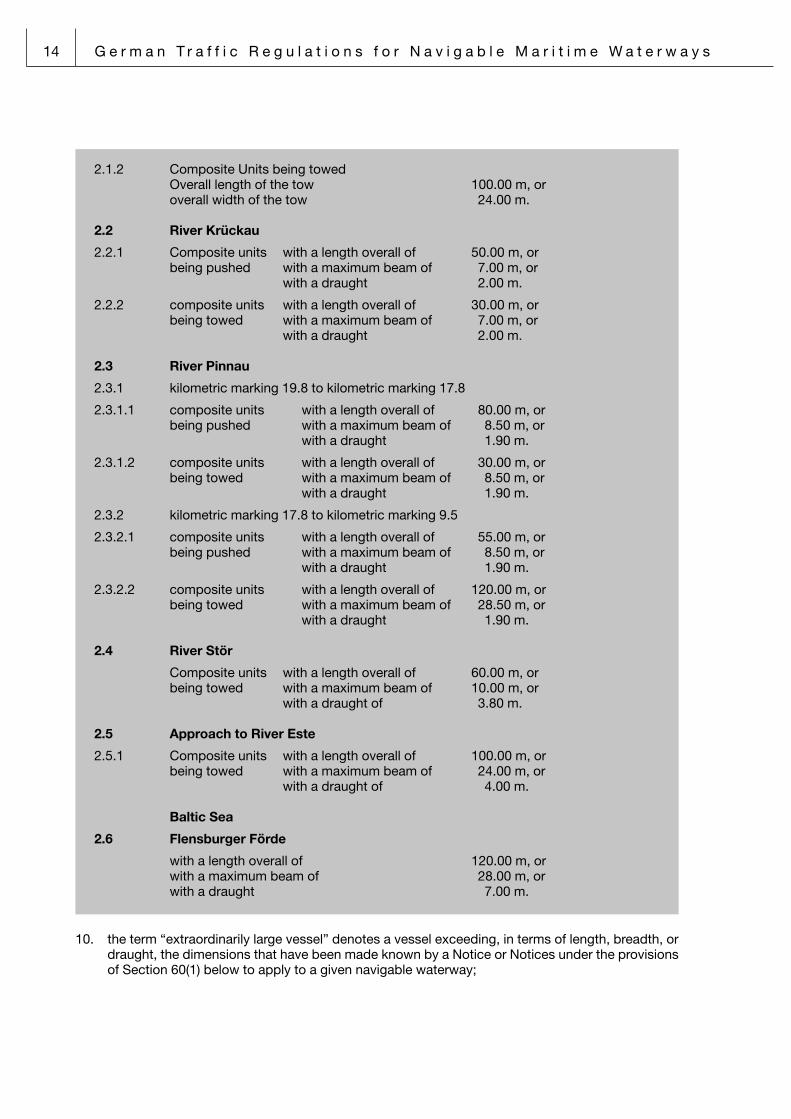
2.1.2 Composite Units being towed Overall length of the tow 100.00 m, or overall width of the tow 24.00 m.
2.2 River Krückau
2.2.1 Composite units with a length overall of 50.00 m, or being pushed with a maximum beam of 7.00 m, or with a draught 2.00 m.
2.2.2 composite units with a length overall of 30.00 m, or being towed with a maximum beam of 7.00 m, or with a draught 2.00 m.
2.3 River Pinnau
2.3.1 kilometric marking 19.8 to kilometric marking 17.8
2.3.1.1 composite units with a length overall of 80.00 m, or being pushed with a maximum beam of 8.50 m, or with a draught 1.90 m.
2.3.1.2 composite units with a length overall of 30.00 m, or being towed with a maximum beam of 8.50 m, or with a draught 1.90 m.
2.3.2 kilometric marking 17.8 to kilometric marking 9.5
2.3.2.1 composite units with a length overall of 55.00 m, or being pushed with a maximum beam of 8.50 m, or with a draught 1.90 m.
2.3.2.2 composite units with a length overall of 120.00 m, or being towed with a maximum beam of 28.50 m, or with a draught 1.90 m.
2.4 River Stör
Composite units with a length overall of 60.00 m, or being towed with a maximum beam of 10.00 m, or with a draught of 3.80 m.
2.5 Approach to River Este
2.5.1 Composite units with a length overall of 100.00 m, or being towed with a maximum beam of 24.00 m, or with a draught of 4.00 m.
Baltic Sea
2.6 Flensburger Förde
with a length overall of 120.00 m, or with a maximum beam of 28.00 m, or with a draught 7.00 m.
10. the term “extraordinarily large vessel” denotes a vessel exceeding, in terms of length, breadth, or draught, the dimensions that have been made known by a Notice or Notices under the provisions of Section 60(1) below to apply to a given navigable waterway;

G e r m a n T r a f f i c R e g u l a t i o n s f o r N a v i g a b l e M a r i t i m e W a t e r w a y s 15
Extraordinarily large vessels (Section 2(1)(Item 10) SeeSchStrO)Extraordinarily large vessels shall be those vessels exceeding any one or more of the following dimensions including the projecting load (the draught values (max. draught in fresh water) indica-ted being applicable on the understanding that the designated water depths are, in fact, existing and that at least median values may be expected for the tide at High Water in tidal waters, res-pectively, for the water level in non-tidal waters.:
North Sea
2 Notice of the Federal Waterways and Shipping Agency – North Western Region Office
2.1 River Jade
Bulk essels Length 350 m Beam 60 m Draught inbound 18 m outbound 17 m All other vessels Length 400 m Beam 60 m Draught inbound 18 m outbound 17 m
2.2 River Weser
2.2.1 Run from The Sea to Bremerhaven (“Stromkaje” Quay) and from Bremerhaven to the Sea
Length 350 m Beam 46 m Draught 14.50 m (freshwater)
2.2.2 Run from The Sea to Nordenham Length 270 m Draught 13.00 m (freshwater)
2.2.3 Run from The Sea to Brake Length 270 m Draught inbound 11.90 m (freshwater) outbound 11.60 m (freshwater)

16 G e r m a n T r a f f i c R e g u l a t i o n s f o r N a v i g a b l e M a r i t i m e W a t e r w a y s
2.2.4 Run from Brake to the turning basin Bremen “Überseehafen” Port a) For Vessels bound to navigate by the tide
L↓ L/B 5.5 5.6 5.7 5.8 5.9 6.0 6.1 6.2 6.3 6.4 6.5
1901)B 34.40 33.90 33.30 32.80 32.20 31.70 31.10 30.60 30.20 29.70 29.20
Dr. 9.50 9.60 9.75 9.85 10.00 10.10 10.20 10.35 10.45 10.60 10.70
1951)B 35.50 34.80 34.20 33.60 33.00 32.50 32.00 31.50 31.00 30.50 30.00
Dr. 9.30 9.40 9.55 9.65 9.80 9.90 10.00 10.15 10.25 10.40 10.50
2002)B 36.40 35.70 35.10 34.50 33.90 33.30 32.80 32.30 31.80 31.30 30.80
Dr. 9.15 9.25 9.40 9.50 9.65 9.75 9.85 10.00 10.10 10.25 10.35
205B 37.50 36.60 36.00 35.30 34.70 34.20 33.60 33.10 32.50 32.00 31.50
Dr. 8.95 9.05 9.20 9.30 9.45 9.55 9.65 9.80 9.90 10.05 10.15
210B 38.20 37.50 36.80 36.20 35.60 35.00 34.40 33.90 33.30 32.80 32.30
Dr. 8.80 8.90 9.05 9.15 9.30 9.40 9.50 9.65 9.75 9.90 10.00
215B 39.10 38.40 37.70 37.10 36.40 35.80 35.20 34.70 34.10 33.60 33.10
Dr. 8.65 8.75 8.90 9.00 9.15 9.25 9.35 9.50 9.60 9.75 9.85
220B 40.00 39.30 38.60 37.90 37.30 36.70 36.10 35.50 34.90 34.40 33.80
Dr. 8.45 8.55 8.70 8.80 8.95 9.05 9.15 9.30 9.40 9.55 9.65
225B 40.90 40.20 39.50 38.80 38.10 37.50 36.90 36.30 35.70 35.20 34.60
Dr. 8.25 8.35 8.50 8.60 8.75 8.85 8.95 9.10 9.20 9.35 9.45
230B 41.80 41.10 40.40 39.70 39.00 38.30 37.70 37.10 36.50 35.90 35.40
Dr. 8.10 8.20 8.35 8.45 8.60 8.70 8.80 8.95 9.05 9.20 9.30
235B 42.70 42.00 41.20 40.50 39.80 39.20 38.50 37.90 37.30 36.70 36.20
Dr. 7.90 8.00 8.15 8.25 8.40 8.50 8.60 8.75 8.85 9.00 9.10
240B 43.60 42.90 42.10 41.40 40.70 40.00 39.30 38.70 38.10 37.50 36.90
Dr. 7.75 7.85 8.00 8.10 8.25 8.35 8.45 8.60 8.70 8.85 8.95
245B 44.50 43.80 43.00 42.20 41.50 40.80 40.20 39.50 38.90 38.30 37.70
Dr. 7.55 7.65 7.80 7.90 8.05 8.15 8.25 8.40 8.50 8.65 8.75
250B 45.40 44.60 43.90 43.10 42.40 41.70 41.00 40.30 39.70 39.10 38.50
Dr. 7.40 7.50 7.65 7.75 7.90 8.00 8.10 8.25 8.35 8.50 8.60
1) Applies only to vessels proceeding upstream2) Maximum permissible draught for vessels proceeding downstream
L = Length in metresB = Beam in metresL/B = Coefficient Length/BeamDr. = Draught in metres

G e r m a n T r a f f i c R e g u l a t i o n s f o r N a v i g a b l e M a r i t i m e W a t e r w a y s 17
2.2.4 Run from Brake to the turning basin Bremen “Überseehafen” Port b) For vessels not bound to navigate by the tide
L 190 195 200 205 210 215 220 225 2301)
L/B B Dr. B Dr. B Dr. B Dr. B Dr. B Dr. B Dr. B Dr. B Dr.
7.2 29.20 7.55 29.90 7.40 30.60 7.30 31.30 7.10 31.90 6.95
7.1 29.60 7.50 30.30 7.35 31.00 7.25 31.70 7.05 32.40 6.90
7.0Max.Dr.
7.60 m29.30 7.60 30.00 7.45 30.70 7.30 31.40 7.20 32.10 7.00 32.90 6.85
6.9 29.70 7.55 30.40 7.40 31.20 7.25 31.90 7.15 32.60 6.95 33.30 6.80
6.8 30.10 7.50 30.90 7.35 31.60 7.20 32.40 7.10 33.10 6.90 33.80 6.75
6.7 29.90 7.60 30.60 7.40 31.30 7.25 32.10 7.10 32.80 7.00 33.60 6.80 34.30 6.65
6.6 30.30 7.55 31.10 7.35 31.80 7.20 32.60 7.05 33.30 6.95 34.10 6.75 34.80 6.60
6.5 30.00 7.60 30.80 7.50 31.50 7.30 32.30 7.15 33.10 7.00 33.80 6.90 34.60 6.70 35.40 6.55
6.4 30.50 7.55 31.30 7.45 32.00 7.25 32.80 7.10 33.60 6.95 34.40 6.85 35.20 6.65 35.90 6.50
6.3 31.00 7.50 31.80 7.40 32.50 7.20 33.30 7.05 34.10 6.90 34.90 6.80 35.70 6.60 36.50 6.45
6.2 31.50 7.40 32.30 7.30 33.10 7.10 33.90 6.95 34.70 6.80 35.50 6.70 36.30 6.50 37.10 6.35
6.1 32.00 7.35 32.80 7.25 33.60 7.05 34.40 6.90 35.20 6.75 36.10 6.65 36.90 6.45 37.70 6.30
6.0 32.50 7.30 33.30 7.20 34.20 7.00 35.00 6.85 35.80 6.70 36.70 6.60 37.50 6.40 38.30 6.25
5.9 33.00 7.25 33.90 7.15 34.70 6.95 35.60 6.80 36.40 6.65 37.30 6.55 38.10 6.35 39.00 6.20
5.8 33.60 7.20 34.50 7.10 35.30 6.90 36.20 6.75 37.10 6.60 37.90 6.50 38.80 6.30 39.70 6.15
5.7 34.20 7.10 35.10 7.00 36.00 6.80 36.80 6.65 37.70 6.50 38.60 6.40 39.50 6.20 40.40 6.05
1) Vessels with a length between 230 m and 250 m shall be trated as “vessels bound to navigate by the tide“.
L = Length in metresB = Beam in metresL/B = Coefficient Length/BeamDr. = Draught in metres
2.2.5 Run from the turning basin Bremen “Überseehafen” Port to the Bremen “Europa-hafen” Port
Length 140 m Beam 20 m Draught 6.50 m (tide-independent) 9.00 m (tide-dependent)
2.2.6 Run from the Bremen “Europahafen” Port to the Bremen Rail Bridge Length 135 m Beam 15 m Draught 2.50 m (tide-independent) 5.50 m (tide-dependent)
2.3 River Hunte
2.3.1 Run from the mouth of River Hunte to Elsfleth (kilometric marking 21.0) Length 105 m Beam 14 m Draught 3.00 m (tide-independent) 6.00 m (tide-dependent)
2.3.2 Run from Elsfleth (kilometric marking 21.0) to Oldenburg (kilometric marking 1.0)
Seagoing vessels Length 86 m Beam 10.5 m
Inland waterway vessels Length 100 m Beam 10.5 m

18 G e r m a n T r a f f i c R e g u l a t i o n s f o r N a v i g a b l e M a r i t i m e W a t e r w a y s
2.3.3 Run from Oldenburg (kilometric marking 1.0) to Oldenburg (kilometric marking 0.0)
Seagoing vessels Length 86 m Beam 10.5 m Draught 2.5 m
Inland waterway vessels Length 100 m Beam 10.5 m Draught 2.5 m
3 Notice of the Federal Waterways and Shipping Agency – Northern Region Office
North Sea
3.1 Husumer Au
with a maximum beam of 13.00 m, or with a draught 3.80 m.
3.2 River Elbe
with a length overall of 330.00 m, or with a maximum beam of 45.00 m.
3.3 River Schwinge
3.3.1 kilometric marking 0.2 to kilometric marking 4.6 with a length overall of 55.00 m, or with a maximum beam of 7.50 m, or with a draught 2.70 m.
3.4 River Este (upstream from the Inneres Sperrwerk Barrier)
with a length overall of 25.00 m, or with a maximum beam of 5.50 m, or with a draught 1.60 m.
3.4.1 Approach to River Este with a length overall of 150.00 m, or with a maximum beam of 25.00 m, or with a draught 4.00 m.
3.5 River Stör (kilometric marking 23.5 to kilometric marking 48)
with a length overall of 85.00 m, or with a maximum beam of 10.00 m, or with a draught 3.80 m.
3.5.1 Mouth of River Stör up to kilometric marking 48.0 with a length overall of 90.00 m, or with a maximum beam of 15.00 m, or with a draught 4.00 m.
3.6 River Krückau
with a length overall of 40.00 m, or with a maximum beam of 6.00 m, or with a draught 1.40 m.

G e r m a n T r a f f i c R e g u l a t i o n s f o r N a v i g a b l e M a r i t i m e W a t e r w a y s 19
3.7 River Pinnau (kilometric marking 9.5 to 19.9)
with a length overall of 67.00 m, or with a maximum beam of 8.00 m, or with a draught 2.80 m.
Baltic Sea
3.8 Flensburger Förde
with a length overall of 180.00 m, or with a maximum beam of 28.00 m, or with a draught 7.00 m.
3.9 Schlei (only up to Kappeln)
with a length overall of 75.00 m, or with a maximum beam of 13.00 m, or with a draught 3.80 m.
3.10 Kieler Förde
with a length overall of 235.00 m, or with a maximum beam of 35.00 m, or with a draught 9.70 m.
3.11 Heiligenhafen
with a length overall of 90.00 m, or with a maximum beam of 13.20 m, or with a draught 4.30 m.
3.12 Neustadt
with a length overall of 90.00 m, or with a maximum beam of 13.50 m, or with a draught 4.50 m.
3.13 River Trave
3.13.1 from Approach Buoy Trave up to the Stülper Huk Landmark (kilometric marking 21.2) with a length overall of 190.00 m, or with a maximum beam of 29.00 m, or with a draught 8.00 m.
3.13.2 Stülper Huk Landmark (kilometric marking 21.2) up to Lightpole 32 (kilometric marking 12.5) with a length overall of 180.00 m, or with a maximum beam of 25.50 m, or with a draught 7.50 m.
3.13.3 Lightpole 32 (kilometric marking 12.5) up to city ports with a length overall of 140.00 m, or with a maximum beam of 19.00 m, or with a draught 6.50 m.
3.14 Wismar with a length overall of 140.00 m, or with a maximum beam of 21.00 m, or with a draught 8.00 m.

20 G e r m a n T r a f f i c R e g u l a t i o n s f o r N a v i g a b l e M a r i t i m e W a t e r w a y s
3.15 River Warnow
3.15.1 Fairway into the port of Rostock up to Berth 60 in the Überseehafen Port with a length overall of 230.00 m, or with a maximum beam of 36.00 m, or with a draught 12.00 m.
3.15.2 Berth 60 in the Überseehafen Port up to Marienehe with a length overall of 125.00 m, or with a maximum beam of 17.50 m, or with a draught 7.50 m.
3.15.3 Marienehe up to city port with a length overall of 125.00 m, or with a maximum beam of 17.50 m, or with a draught 5.50 m.
3.16 Northern Approach to Stralsund
3.16.1 by day and at a range of visibility of more than 1000 m with a length overall of 95.00 m, or with a maximum beam of 13.00 m, or with a draught 3.70 m, or with a maximum height of 37.00 m.
3.16.2 by night and at a range of visibility of less than 1000 m with a length overall of 80.00 m, or with a maximum beam of 13.00 m, or with a draught 3.50 m, or with a maximum height of 37.00 m.
3.17 Eastern Approach to Stralsund including the Landtief Shoals
3.17.1 Landtief Shoals to Stralsund South (Süd) with a length overall of 140.00 m, or with a maximum beam of 20.00 m, or with a draught 6.10 m.
3.17.2 Landtief Shoals to Stralsund City Port (Stadthafen) with a length overall of 120.00 m, or with a maximum beam of 14.00 m, or with a draught 4.80 m, or with a maximum height of 37.00 m.
3.17.3 Landtief Shoals to Ports of Lubmin/Vierow/Ladebow with a length overall of 120.00 m, or with a maximum beam of 17.50 m, or with a draught 5.70 m.
3.18 Peenestrom including the Osttief Shoals up to Wolgast
3.18.1 by day and at a range of visibility of more than 1000 m and winds not exceeding force 5 Bft
with a length overall of 115.00 m or more, or with a maximum beam of 20.00 m or more, or with a draught 5.20 m or more.
3.18.2 by night and at a range of visibility of less than 1000 m and winds exceeding force 5 Bft
with a length overall of 90.00 m or more, or with a maximum beam of 17.50 m or more, or with a draught 5.00 m or more.

G e r m a n T r a f f i c R e g u l a t i o n s f o r N a v i g a b l e M a r i t i m e W a t e r w a y s 21
3.19 Peenestrom from Landtief via Loch up to Wolgast (approaching from northerly directions)
3.19.1 by day and with a range of visibility of more than 1 000 m and winds not exceeding 5 Bft
with a length overall of 115.00 m or with a maximum beam of 20.00 m or draught 5.70 m
3.19.2 by night and with a range of visibility of 1 000 or less or with winds exceeding 5 Bft with a length overall of 90.00 m or with a maximum beam of 17.50 m or draught 5.50 m
10a. the term “high-speed craft” denotes a vessel built and operated in accordance with the provisions of the International Code of Safety for High-Speed Craft (promulgated in the “Bundesanzeiger” 21a of 3 January 1996) and other vessels operated in accordance with the said Code;
11. the term “passenger vessel” denotes a vessel engaged in, or provided for, the carriage of more than twelve persons on a commercial basis;
12. the term “ferry” denotes a vessel employed for crossing traffic between any two opposite banks or embankments;
13. the term “right-of-way vessel” denotes (a) either a vessel (other than a vessel passing through the Kiel Canal) exceeding the dimensions
that have been made known by a Notice or Notices under the provisions of Section 60(1) below to apply to a given navigable waterway or a vessel being forced to navigate in the dee-pest channel of a fairway on account of her draught, her length, or some other characteris-tics;
(b) a vessel navigating in the waters that extend between the seaward delimitation in terms of Items 1 and 2 of the second sentence of Section 1(1) above and the seaward delimitation of the territorial sea, and fulfilling the relevant preconditions made known by a Notice or Notices under the provisions of Section 60(1) below by the competent shipping police authority;
any such vessel shall be deemed a “vessel restricted in her ability to manœuvre” in terms of Rule 3(g) of the International Regulations for Preventing Collisions at Sea, 1972, as amended;
Right-of-way vessels (Section 2(1)(Items 13a and b) SeeSchStrO)
3/4 Notice of the Federal Waterways and Shipping Agency – Northern and North Western Region Office
Every vessel wishing to enjoy the right of way shall send a dedicated message indi-cating this wish to the competent Vessel Traffic Centre.
“Right-of-way vessels” shall be those vessels that comply with any one or more of the following conditions:
– They exceed the dimensions listed below. – They are constrained, by any other characteristics, to make use of the deepest
part of the fairway. – They fulfil the conditions specified hereunder.
3.1/4.1 Inner German Bight
Vessels en route from Lightvessel German Bight or from the deepwater roadstead to River Jade, River Weser or River Elbe and who, on account of their draught, are bound to navigate by the tide in the district ahead of them and, therefore, enjoy the right of way.

22 G e r m a n T r a f f i c R e g u l a t i o n s f o r N a v i g a b l e M a r i t i m e W a t e r w a y s
14. the term “inland vessel” denotes a vessel to which a “Fahrtauglichkeitsbescheinigung” – which is a certificate of fitness for inland navigation under the provisions of the Inland Vessels (Surveys and Certification) Ordinance of 6 December 2008 (promulgated in the Federal Law Gazette I, p 2450) in the current version has been issued; this term includes inland vessels flying a foreign flag;
15. the term “exempt vessel” denotes a vessel that is exempted from otherwise compulsory pilota-ge;
16. the term “certain dangerous goods” comprises – any quantity exceeding an aggregate of 100 kilograms per vessel of goods of Class 1 – Divi-
sions 1.1, 1.2, and 1.3 – , Class 4.1, and Class 5.2 in terms of the International Maritime Dangerous Goods Code (official German translation promulgated in the “Bundesanzeiger” 158a of 23 August 1995), provided, in the cases of goods of Classes 4.1 and 5.2, that they must bear the subsidiary risk label “EXPLOSIVE”;
– any quantity of goods referred to in Section 30(1)(Item 1) below, when carried in bulk in tan-kers or in composite units;
17. the term “flashpoint” denotes the lowest temperature, expressed in degrees Centigrade, at which inflammable vapours develop in such quantity as to be capable of being ignited. Flashpoint values given in the present Ordinance refer to tests made by applying the closed-cup method and using an approved type of test apparatus;
18. for the purposes of the present Ordinance’s provisions applying to the Kiel Canal, (a) the term “vessel category” denotes a category of vessels as made known by a Notice or
Notices under the provisions of Section 60(1) below; (b) the term “pleasure craft” denotes a vessel used exclusively for the purposes of sports and
pleasure; (c) the term “siding” denotes waters dedicated for the purposes of waiting for, meeting, or
overtaking other vessels; (d) the term “approach channel” denotes waters on the seaward side of the by-ports at the
entrance locks to the Kiel Canal. Such approach shall be deemed a “fairway” for the purpo-ses of the present Ordinance;
(e) the term “by-port”, when not accompanied by a qualifying adjective, denotes the waters extending between a line connecting the seaward lock-heads and a line connecting the seaward entrance lights at the Brunsbüttel respectively the Kiel-Holtenau Locks;
Notice of the Federal Waterways and Shipping Agency – North Western Region Office
3.2 River Weser a) Run from The Sea to Bremerhaven (“Stromkaje” Quay) Draught 12.30 m (freshwater) b) Run from Bremerhaven to Nordenham Draught 10.00 m (freshwater) c) Run from Nordenham to Brake Draught 7.92 m (freshwater)

G e r m a n T r a f f i c R e g u l a t i o n s f o r N a v i g a b l e M a r i t i m e W a t e r w a y s 23
5 Traffic Categories on the Kiel Canal (Section 2(1)(Item 18a) SeeSchStrO)
5.1 Notice of the Federal Waterways and Shipping Agency – Northern Region Office
The term “traffic category” denotes various groups of vessels as defined for the purposes of Vessel Traffic, account being taken of the following definitions:
5.1.1 Particularly dangerous vessels and composite units:
5.1.1.1 Term includes vessels and composite units carrying certain dangerous goods in terms of Section 2(1)(Item 16) SeeSchStrO; excluding tankers carrying goods in terms of Section 30(1) (Item1c) SeeSchStrO with a flashpoint of 55°C and above.
5.1.1.2 Term includes tankers carrying other not in Section 30(1) (Item 1b) SeeSchStrO speci fied chemical goods with a flash-point below 55°C.
5.1.1.3 Term excludes empty tankers having carried goods in terms of aforementioned tirets with a flashpoint below 55°C as far as the tanks have not been cleaned and de-gassed or completely inerted afterwards.
5.1.2 Length: Term denotes the “length overall” in the case of vessels and composite units being
pushed. In the case of composite units being towed, it denotes the added lengths overall of the tug and complete tow, including rigidly connected tugs, not including the towing line.
5.1.3 Beam: Term denotes the “maximum breadth” of a vessel or composite unit including any
rigid parts protruding over the main body.
5.1.4 Draught: Term denotes the “maximum draught” of a vessel or composite unit.
5.2 How to arrive at the correct traffic category when other than whole numbers are given:
Values for length and beam should be interpolated, with 1.00 metre of length corre-sponding to 0.10 metres of breadth. Length values below 0.5 should be rounded down to the next whole metre and breadth values below 0.5 should be rounded down to the next whole decimetre, whereas length values of 0.5 and above should be rounded up to the next whole metre and breadth values of 0.5 and above should be rounded up to the next whole decimetre.
5.3 Traffic category 1
5.3.1 Vessels and composite units being pushed other than those within the description of particularly dangerous vessels and composite units being pushed are up to
with a length overall of 125.00 m, or a length of 45.00 m / 55.00 m a beam of 9.50 m / 8.50 m a draught of 3.10 m / 3.10 m or, in case of multiple-hulled craft for sporting purposes a lenght of 20.00 m a beam of 12.00 m a draught of 3.10 m
5.3.2 Composite units being towed other than those within the description of particularly dangerous composite units being towed are up to
a lenght of 65.00 m a beam of 10.00 m a draught of 3.10 m

24 G e r m a n T r a f f i c R e g u l a t i o n s f o r N a v i g a b l e M a r i t i m e W a t e r w a y s
5.4 Traffic category 2
5.4.1 Vessels and composite units being pushed other than those of traffic category 1 plus other than those within the description of particularly dangerous vessels and composite units being pushed are up to
a length of 45.00 m / 55.00 m a lenght of 65.00 m / 85.00 m a beam of 13.00 m / 11.00 m a draught of 3.70 m / 3.70 m or, in the case of an inland vessel a lenght of 105.00 m a beam of 9.00 m a draught of 3.10 m
5.4.2 Composite units being towed other than those of traffic category 1 plus other than those within the description of particularly dangerous composite units being towed are up to
a lenght of 85.00 m a beam of 13.50 m a draught of 3.70 m
5.5 Traffic category 3
5.5.1 Vessels and composite units being pushed other than those of any of the above traffic categories plus other than those within the description of particularly dange-rous vessels and composite units being pushed are up to
a lenght of 120.00 m / 140.00 m a beam of 19.00 m / 17.00 m a draught of 6.10 m / 6.10 m
5.5.2 Composite units being towed other than those of any of the above traffic categories plus other than those within the description of particularly dangerous composite units being towed are up to
a lenght of 135.00 m a beam of 19.00 m a draught of 6.10 m
5.5.3 Particularly dangerous vessels and composite units being pushed and towed with measurements of the traffic categories 1 and 2. Exempt are double-hull tankers as well as particularly dangerous vessels and composite units being pushed and tow-ed when shipping certain dangerous goods in containers.
5.6 Traffic category 4
5.6.1 Vessels and composite units being pushed other than those of any of the above traffic categories plus other than those within the description of particularly dange-rous vessels and composite units being pushed are up to
a length of 130.00 m / 160.00 m a beam of 23.50 m / 20.50 m a draught of 9.50 m / 9.50 m
5.6.2 Composite units being towed other than those of any of the above traffic categories plus other than those within the description of particularly dangerous composite units being towed are up to
a length of 155.00 m a beam of 23.50 m a draught of 6.10 m
5.6.3 Particularly dangerous vessels and composite units being pushed and towed with measurements of the traffic category 3. Exempt are double-hull tankers as well as particularly dangerous vessels and composite units being pushed and towed when shipping certain dangerous goods in containers.

G e r m a n T r a f f i c R e g u l a t i o n s f o r N a v i g a b l e M a r i t i m e W a t e r w a y s 25
5.7 Traffic category 5
5.7.1 Vessels and composite units being pushed other than those of any of the above traffic categories are up to
a length of 200.00 m / 210.00 m a beam of 28.00 m / 27.00 m
5.7.2 Composite units being towed other than those of any of the above traffic categories are up to
a length of 185.00 m in length a beam of 27.00 m a draught of 9.50 m in draught
5.7.3 Particularly dangerous vessels and composite units being pushed and towed with measurements of the traffic category 4 and 5. Exempt are double-hull tankers as well as particularly dangerous vessels and composite units being pushed and tow-ed when shipping certain dangerous goods in containers.
5.8 Traffic category 6
5.8.1 All vessels and composite units being pushed and towed other than those of any of the above traffic categories.
5.8.2 Approved extraordinary composite units being towed (Section 2 (1) (Item 9) See-SchStrO) other than those of any of the above traffic categories.
5.9 Upgrading on a case-by-case basis: The Waterways and Shipping Office at Brunsbüttel or Kiel-Holtenau, as the case
may be, may upgrade individual vessels and composite units so as to fall into a higher vessel category, if the safety of traffic so requires.
19. the term “visual signs of a vessel” comprises lights, shapes, flags, and tables;
20. the term “shapes of a vessel” comprises spheres, cones, diamonds, and cylinders;
21. the term “jetbike” denotes any type of water-sports equipment featuring water-jet propulsion and commonly known by such names as “water bob”, “water scooter”, “jetbike”, “jet ski”, or the like. No such item of equipment shall be deemed a “vessel” for the purposes of the present Ordi-nance;
21a. the term “parasailing” comprises hang-gliding and parachute-flying behind a towing water craft;
21b. the term “towing of gear for water-sports” comprises towing of inflatable buoyant hulls carrying persons by tractor craft;
21c. kite surfing the term kite surfing comprises surfing behind a surfboard towed by a kite;
22. the term “maritime traffic control” comprises the whole complex of traffic information and traffic assistance provided, and any restraints for the control and regulation of traffic issued or imposed, by a VTS centre for preventing collisions and groundings, for controlling the traffic flow, or for preventing hazards to the marine environment as may arise from shipping;
23. the term “traffic information” denotes navigational warnings and other information as may be pro-vided by a VTS centre at pre-determined times, or at regular intervals, or upon request of individu-al vessels, and which may cover such aspects as fairway, weather and tidal conditions or the prevailing traffic situation;

26 G e r m a n T r a f f i c R e g u l a t i o n s f o r N a v i g a b l e M a r i t i m e W a t e r w a y s
24. the term “traffic assistance” denotes advice and warnings as may be provided to the shipping community by a VTS centre as well as recommendations provided through a VTS centre by sea pilots advising ships under the provisions of Section 23(1) of the Sea Pilotage Act as per Official Notice of 13 September 1984 (promulgated in the Federal Law Gazette I, p 1213) and last modi-fied by Article 3 of the Act of 17 July 1997 (promulgated in the Federal Law Gazette I, p 1832); such advice, warnings, and recommendations being provided in restricted visibility, or upon request, or when a VTS centre, upon assessment of its observation of traffic, deems it necessary to provide them; they may cover such aspects as the positions kept, the courses steered, the speeds attained and the manœuvres made by specific vessels as well as the times of given ves-sels passing given points (as fairway, weather and tidal conditions or the prevailing traffic situation may require);
25. the term “traffic instructions” denotes injunctions as may be imposed, on a case-by-case basis, by a VTS centre acting in its capacity as shipping police authority; such traffic instructions may cover right-of-way, overtaking, or head-on situations, minimum and maximum speeds, or may specify details to be observed by vessels proceeding on a given navigable waterway (as fairway, weather and tidal conditions or the prevailing traffic situation may require);
26. the term “traffic flow control” denotes measures as may be taken by one or both of the VTS cen-tres on the entrances to the Kiel Canal for the purpose of averting dangers or controlling the traffic flow;
27. the term “VTS centre” (which is the commonly used abbreviated form of the term “vessel traffic services centre”) denotes any one of the centres set up by the Federal Waterways and Shipping Administration for the control of traffic in, as well as en route to and from, a given shipping dis-trict.
28. AIS the term “AIS” denotes a shipborne automatic identification system as defined by regulation
V/19.2.4 of the International Convention for the Safety of Life at Sea, 1974 (Federal Law Gazette 1979 II p. 141), as last amended in accordance with the Act of 22 December 2003 (Federal Law Gazette 2003 II p. 2018).
(2) For the purposes of the present Ordinance,
1. the expression “by day” means the time between sunrise and sunset;
2. the expression “by night” means the time between sunset and sunrise.
Section 3 Basic rules for conduct in traffic
(1) The conduct of every person taking part in shipping traffic shall be such as to ensure the safety and easy flow of shipping traffic and to avoid any other person to be exposed to any damage or detri-ment, to be put at risk, or to be impeded or molested any more than is inevitable in the circumstances prevailing. Every person taking part in shipping traffic shall, in particular, take any precaution as may be required by the practice of good seamanship or by the special circumstances of the case. Any person in command of a vessel that is fitted with a VHF radiotelephone installation, while complying with appli-cable rules and regulations governing the conduct of vessels taking part in shipping traffic, shall main-tain a listening watch for traffic information and assistance provided by a VTS centre – such information and assistance being, routinely, given in German and, upon request, in English – and shall take imme-diate account thereof in accordance with the circumstances of the traffic situation prevailing.

G e r m a n T r a f f i c R e g u l a t i o n s f o r N a v i g a b l e M a r i t i m e W a t e r w a y s 27
(2) With due regard to the specific circumstances prevailing, any necessary action shall be taken to avoid immediate danger, even if doing so should require a departure from the provisions of the present Ordinance.
(3) No person, when impaired in his or her ability to safely navigate a vessel or safely perform other bridge, deck or machinery services as a result of physical or mental deficiencies or of the intake of alcoholic beverages or other intoxicating substances, shall navigate a vessel nor perform other bridge, deck or machinery services as a member of the ship’s crew. This rule shall apply, mutatis mutandis, to riding a jetbike and to kite- and wind-surfing.
(4) No person with a breath alcohol content of 0.25 mg/l or more or a blood alcohol content of 0.5 alcohol level or more or after an intake of alcohol that may lead to such a breath or blood alcohol con-tent shall navigate a vessel nor perform other bridge, deck or machinery services as a member of the ship’s crew. This rule shall apply, mutatis mutandis, to riding a jetbike and to kite- and wind-surfing.
(5) The master of passenger ship or a vessel subject to the bans and restrictions affecting navigation in accordance with Section 30(1) may neither consume alcoholic beverages when working during the journey, nor be under the influence of such beverages at the start of work. During rest periods and other recreational periods on board, the master may consume alcoholic beverages if it can be ensured that he or she is no longer under the influence of such beverages when carrying out safety-critical tasks. Sentence 1 also applies to crew members carrying out bridge service.
Section 4 Responsibility
(1) Any person in command of a vessel as well as any other person responsible for safety shall com-ply with the provisions of the present Ordinance on conduct in traffic and on the equipment of vessels with arrangements for exhibiting visual signs and making sound signals. As far as inland vessels are concerned, such compliance shall also be due by any member of the crew who may temporarily be engaged in determining the vessel’s course and speed on his or her own.
(2) A sea pilot shall also be a person responsible in terms of the present Ordinance; he shall provide advice to the person in command of the vessel so as to put such person in a position to comply with the provisions of the present Ordinance.
(3) Notwithstanding the provisions of paragraph (1) above, the person in command of a composite unit, whether pushed or towed, shall be responsible for the safe navigation of such composite unit. The person in command of the composite unit shall be the person in command of the tug, respectively, the pushing vessel; however, the persons in command of the vessels involved may, before commencing the voyage, designate the person in command of one of the vessels other than the tug, respectively the towing vessel, to be the person in command of the composite unit.
(4) When no person has been identified as being in command of a given vessel and more than one person is entitled to navigate such vessel, the persons so entitled shall, before commencing the voya-ge, designate the person to be in command of the said vessel.
(5) The provisions of the present Section shall not affect the responsibility of other persons as may be provided for elsewhere in this Ordinance or in any other applicable instrument.

28 G e r m a n T r a f f i c R e g u l a t i o n s f o r N a v i g a b l e M a r i t i m e W a t e r w a y s
Section 5 Signs and signals for navigational purposes
(1) For the purposes of the present Ordinance, the term “signs and signals for navigational purposes” shall comprise visual signs and sound signals embodying requirements, prohibitions, warnings, and/or advice. An exhaustive list of such signs and signals for navigational purposes in use in the area of appli-cation of the present Ordinance and embodying requirements or prohibitions is given at Annex I to the present Ordinance; further such signs and signals are referred to in the ordinances issued under the provisions of Section 60(2) below. Any products manufactured in other Member States of the European Union and not complying with the technical requirements specified in Annex I to the present Ordinance (as well as any related tests, approvals, and inspections conducted in the country of such product’s origin) shall be deemed to be equivalent if the said product will provide, with the same degree of per-manence, the required level of protection with regard to safety, health, and fitness for use.
(2) Any orders given by means of signs or signals for navigational purposes, embodying requirements or prohibitions, shall be complied with.
(3) Any action damaging signs or signals for navigational purposes or affecting the capability of such signs or signals of being discerned and identified shall be prohibited.
Section 6 Visual signs and sound signals of vessels
(1) Unless otherwise provided for in the following provisions, vessels may, in addition to the visual signs and sound signals prescribed under the provisions of the International Regulations for Preventing Collisions at Sea, 1972, as amended, only exhibit the visual signs and make the sound signals as pro-vided for in Annex II to the present Ordinance and shall do so for no other purposes than those provi-ded for in that Annex. The visual signs and sound signals prescribed under the provisions of the Inter-national Code of Signals shall be used for no other purposes than those provided for in that Code. No visual signs shall be exhibited, nor any sound signals be made, that may be mistaken for those prescri-bed or provided for. The application of the present provision shall not affect the application of the pro-visions of the “Allgemeine Zollordnung” (the German General Customs Ordinance) nor of Rule 1(c) or (e) of the International Regulations for Preventing Collisions at Sea, 1972, as amended.
(2) Lanterns, lights, and searchlights shall be used only so as to avoid undue glare as might jeopardi-ze or impede the safe navigation of other vessels.
(3) The provisions of Rule 33 of the International Regulations for Preventing Collisions at Sea, 1972, as amended, shall apply, mutatis mutandis, to equipment for making the sound signals prescribed in the present Ordinance. The efficiency and operational safety of such sound-signalling appliances shall be ensured at all times. Whenever it is obvious that their efficiency or operational safety is impaired, the person in command of the vessel concerned as well as such vessel’s owner shall, without delay, make arrangements for proper repairs to be carried out.
(4) Any products manufactured in other Member States of the European Union and not complying with the technical requirements specified in the present Ordinance (as well as any related tests, appro-vals, and inspections conducted in the country of such product’s origin) shall be deemed to be equiva-lent if the said product will provide, with the same degree of permanence, the required level of protec-tion with regard to safety, health, and fitness for use.

G e r m a n T r a f f i c R e g u l a t i o n s f o r N a v i g a b l e M a r i t i m e W a t e r w a y s 29
Section 7 Vessels in the Public Service
Vessels in the Public Service shall be exempt from the provisions of the present Ordinance to the extent that this is imperative for the fulfilment of tasks arising from the exercise of sovereignty, due account being taken of all aspects of ordre public. In the event that the safety or easy flow of traffic is put at risk in the execution of police duties, the visual sign described under Item 1 of Annex II.1 to the present Ordinance shall be exhibited.
Sentence 1 also applies to vessels of the German Society for the Rescue of Shipwrecked Sailors inso-far as they perform search and rescue services in the event of an emergency at sea in accordance with Section 1 no. 7 of the Maritime Navigation (Federal Competences) Act.
30 G e r m a n T r a f f i c R e g u l a t i o n s f o r N a v i g a b l e M a r i t i m e W a t e r w a y s
Part Two
Visual signs of and sound signals of vessels
Section 8 General
(1) The provisions of Rule 20 of the International Regulations for Preventing Collisions at Sea, 1972, as amended, as well as those of Annex I thereto shall apply, mutatis mutandis, to matters related to the visual signs prescribed by the present Ordinance. Any visual signs to be exhibited under the provisions of the present Ordinance and under those of the International Regulations for Preventing Collision at Sea, 1972, as amended, shall be carried on board at all times and shall be fixed in their appropriate place throughout the time during which they shall be exhibited. No visual signs other than signs visible over the whole horizon shall be exhibited, and they shall be exhibited where they can best be seen. The third sentence of the present paragraph shall only apply unless this Ordinance expressly provides otherwise. In derogation of the provisions of the first sentence of the present paragraph, the following provisions shall not apply to inland vessels when navigating on the inshore side of waters within Zone 2 as defined in Annex 1 to the Inland Vessels (Surveys and Certification) Ordinance:
a) The first sentence of Section 5 of Annex I to the International Regulations for Preventing Collisions at Sea, 1972, as amended, shall not apply, provided that the navigation lights actually used will comply, without screens fitted, with the provisions of Section 9 of Annex I to the International Regulations for Preventing Collisions at Sea, 1972, as amended, or with the provisions referred to in Section 9(4) of the present Ordinance with respect to the horizontal distribution of light.
b) When sidelights with screens fitted are used, those provisions of the first and second sentences of Section 5 of Annex I to the International Regulations for Preventing Collisions at Sea, 1972, as amended, prescribing that screens must be painted matt black shall not apply.
(2) The minimum range of visibility of any of the lights prescribed under the provisions of the present Ordinance for vessels or extraordinary floating objects shall comply with COLREGs Rule 22.
(3) Any shape prescribed under the present Ordinance may be substituted for by an arrangement that, when viewed from any direction from a dis-tance, has the same appearance as the shape it subs-titutes.
(4) Unless otherwise provided for, the flags and tables to be exhibited by vessels under the provisions of the present Ordinance shall be of a rectangular format, each side measuring not less than 1 metre. Colours shall not be pale or faded, nor shall such flags and tables be dirty. Instead of the flags prescri-bed in the present Ordinance, tables of the same size, shape, and colour as any such flag may be exhi-bited. On vessels of less than 20 metres in length, flags and tables of a size smaller than that prescribed in the present Ordinance may be used, provided that their size is commensurate with the size of the pertinent vessel.
(5) [This paragraph has been suspended.]

G e r m a n T r a f f i c R e g u l a t i o n s f o r N a v i g a b l e M a r i t i m e W a t e r w a y s 31
Section 9 Use of navigation lights and sound-signalling appliances
(1) To comply with the provisions of the present Ordinance on the use of lights and sound signals, vessels entitled to fly the flag of the Federal Republic of Germany may use only such navigation lights and sound-signalling appliances as have been type-approved for use on navigable waterways by a “designated body” in terms of Article 9, construed in conjunction with Article 10, of Council Directive 96/98/EC of 20 December 1996 on marine equipment (promulgated in the Official Journal of the Euro-pean Communities L 46, p 25). The provisions of Section 5, construed in conjunction with the provisi-ons of Annex I Section A. I of the Ship Safety Ordinance of 18 September 1998 (promulgated in the Federal Law Gazette I. pp 3013, 3023) and last amended by Article 2 of the Ordinance of 24 June 1999 (promulgated in the Federal Law Gazette I. p 1462), shall apply, mutatis mutandis. Sentences 1 and 2 do not apply to small craft under Art. 1 para. 2 of the ordinance of the provision of small craft and traffic of small craft and to water craft under Art. 1 para. 7 nos. 1–11 of the same ordinance.
(2) In derogation of the provisions of Item 11 of Annex I to the International Regulations for Preventing Collisions at Sea, 1972, as amended, navigation lights shall be operated by electrical current. Notwith-standing this general provision, non-electric navigation lights may be used on a vessel under oars or under sail when such vessel is less than 20 metres in length and is not fitted with an adequate source of electrical power; such lights may also be used on an unmanned vessel, on a manned inland vessel without propulsion machinery, and as reserve lighting of an inland vessel as referred to in Aneex III § 6.06 (c) of the Inland Vessels (Surveys and Certification) Ordinance.
(3) In derogation of the provisions of Item 2(a)(i) of Annex I to the International Regulations for Preven-ting Collisions at Sea, 1972, as amended, the masthead light of any vessel – including vessels the breadth of which exceeds 6 metres – need be placed only at a height above the hull of not less than 6 metres. In derogation of the provisions of Item 2(i) of Annex I to the International Regulations for Pre-venting Collisions at Sea, 1972, as amended, lights to be carried above each other in a vertical line need be spaced not less than 1 metre apart on vessels operated by the Federal Customs Services, the Water Police or the Federal Border Guard.
4) On inland waterway vessels in the sense of Art. 8 para. 1 sentence 5, it is also permitted to use navigation lights for the purpose of lighting according to this Ordinance and the Collision Regulations that are authorized by the Federal Maritime and Hydrographic Agency and designated as bright lights or, when used as top lights, as strong lights according to Annex II Art. 7.05 of the Inland Waterway Vessel Inspection Ordinance (BinSchUO) of 6 December 2008 (Federal Law Gazette I p. 2450) as last amended by Article 1 of the Ordinance of 20 December 2012 (Federal Law Gazette I p. 2802), in the currently valid and applicable version. If the efficiency or operational safety of these navigation lights is affected, then they must be properly repaired or replaced immediately.
(5) In derogation of the provisions of Section 2(a) of Annex I to the International Regulations for Pre-venting Collisions at Sea, 1972, as amended, inland vessels, when navigating on the inshore side of waters within Zone 2 as defined in Annex 1 to the Inland Vessels (Surveys and Certification) Ordinance, need have their forward white light – or, if only one white light is carried, such only white light – placed only at a height above the hull of not less than 5 metres and, when two masthead lights are carried, need have the aft one placed only in a vertical line at least 3 metres higher than the forward one.

32 G e r m a n T r a f f i c R e g u l a t i o n s f o r N a v i g a b l e M a r i t i m e W a t e r w a y s
Section 10 Small vessels
(1) [This paragraph has been suspended.]
(2) In derogation of the provisions of Rule 25(d) of the International Regulations for Preventing Colli-sions at Sea, 1972, as amended, sailing vessels of less than 12 metres in length and vessels under oars, when incapable of exhibiting the lights prescribed by Rule 25(a) or (b) of the International Regula-tions for Preventing Collisions at Sea, 1972, as amended, shall at least exhibit one all-round white light in terms of Rule 21(e) of the International Regulations for Preventing Collisions at Sea, 1972, as amen-ded.
(3) No vessel of the categories referred to in paragraph (2) above, when incapable of exhibiting the lights prescribed in that paragraph, nor any power-driven vessel of less than 7 metres in length, when incapable of exhibiting the lights prescribed by Rules 23(a) and (d) of the International Regulations for Preventing Collisions at Sea, 1972, as amended, shall be underway during the time when lights are prescribed to be exhibited, except in an emergency. To provide for the latter case, an electric torch or a lantern showing a white light shall be carried aboard at all times in such condition as to be readily available for use, and such torch or lantern shall be exhibited in sufficient time to prevent collision.
(4) No vessel of less than 12 metres in length, when at anchor in waters that have been made known by a Notice or Notices under the provisions of Section 60(1) below as anchoring or mooring grounds, need exhibit the visual signs prescribed by Rule 30(a), (b) or (c) of the International Regulations for Pre-venting Collisions at Sea, 1972, as amended; however, this provision shall be without prejudice to the provisions of Rule 30(e) of the International Regulations for Preventing Collisions at Sea, 1972, as amended.
Anchoring and mooring sites for small craft (Section10(4) SeeSchStrO)
Anchoring and mooring sites where the requirement to exhibit the visual signs prescribed under the provisions of Rule 30(a), (b) or (c) of the International Regulations for Preventing Collisions at Sea, 1972, as amended, does not apply to vessels of less than 12.00 m in length:
North Sea
4 Notice of the Federal Waterways and Shipping Agency – North Western Region Office
4.1 River Weser
4.1.1 Between kilometric marking 56.8 and kilometric marking 57.1
4.1.2 kilometric marking 63
4.1.3 Between kilometric marking 39.65 and kilometric marking 40.0 (West Shore)

G e r m a n T r a f f i c R e g u l a t i o n s f o r N a v i g a b l e M a r i t i m e W a t e r w a y s 33
4.2 River Lesum
4.2.1 South Shore a) between kilometric marking 1.8 and kilometric marking 2.0 b) between kilometric marking 3.0 and kilometric marking 4.6 c) between kilometric marking 5.15 and kilometric marking 8.7
4.2.2 North Shore a) between kilometric marking 2.8 and kilometric marking 3.7 b) between kilometric marking 4.6 and kilometric marking 5.8 c) between kilometric marking 7.2 and kilometric marking 7.5 d) between kilometric marking 8.7 and kilometric marking 9.3
4.3 River Wümme
4.3.1 South Shore a) between kilometric marking 2.4 and kilometric marking 3.0 b) between kilometric marking 14.6 and kilometric marking 14.9
4.3.2 North Shore a) between kilometric marking 0.25 and kilometric marking 1.3 b) between kilometric marking 16.5 and kilometric marking 17.0
6 Notice of the Federal Waterways and Shipping Agency-Northern Region Office
6.1 Anchorages
North Sea
6.1.1 Lister Tief Shoals North of List Harbour
6.1.2 Blidsel Bucht
6.1.3 area South of Munkmarsch Yacht Harbour
6.1.4 Vortrapptief Shoals North of Hörnum Harbour
6.1.5 Amrum Harbour between Steenodde and Wittdün
6.1.6 Föhrer Ley South of Wyk Harbour
6.1.7 Dagebüller Fahrwasser North of Dagebüll Harbour
Kiel Canal
6.1.8 Flemhuder See
Baltic Sea
6.1.9 Flensburger Förde
North of Holnis
6.1.10 Schlei
6.1.10.1 Wormshöfter Noor North of latitude 54° 41’ 00’’ N
6.1.10.2 Lindauer Noor West of longitude 009° 49’ 00’’ E
6.1.10.3 Missunder Noor South of latitude 54° 31’ 44’’ N

34 G e r m a n T r a f f i c R e g u l a t i o n s f o r N a v i g a b l e M a r i t i m e W a t e r w a y s
(5) In derogation of the provisions of Rule 26(c) of the International Regulations for Preventing Colli-sions at Sea, 1972, as amended, fishing vessels featuring an open deck need exhibit only one all-round white light in terms of Rule 21(e) of the International Regulations for Preventing Collisions at Sea, 1972, as amended. However, this provision shall be without prejudice to the provisions of Rule 26(b) of the International Regulations for Preventing Collisions at Sea, 1972, as amended.
Section 11 Signals of inland waterway vessels
(1) Inland waterway vessels which are not subject to safe manning regulations are not required to give the signals prescribed in Rule 33, International Regulations for Preventing Collisions at Sea.
(2) For the purposes of the Binnenschifffahrtsordnung (German Traffic Regulations for Inland Water-ways), a composite unit is regarded as a power-driven vessel and is required to give the sound signals prescribed for power-driven vessels according to Rule 33, International Regulations for Preventing Col-lisions at Sea.
Sections 12 through 18 [These Sections have been suspended.]

G e r m a n T r a f f i c R e g u l a t i o n s f o r N a v i g a b l e M a r i t i m e W a t e r w a y s 35
Part Three
Sound signals of vessels
Sections 19 and 20 [These Sections have been suspended.]

36 G e r m a n T r a f f i c R e g u l a t i o n s f o r N a v i g a b l e M a r i t i m e W a t e r w a y s
Part Four
Sailing rules
Section 21 Basic principles
(1) The sailing rules contained in the present Part as well as those contained in Part Seven shall apply irrespective of the conditions of visibility prevailing. In derogation of the provisions of Rules 11 and 19 of the International Regulations for Preventing Collisions at Sea, 1972, as amended, the provisions of Rules 13(a) and (c) as well as those of Rules 14(a) and (c) of the International Regulations for Preventing Collisions at Sea, 1972, as amended, shall apply to vessels in a fairway even if such vessels are not in sight of each other but have located each other by radar.
(2) When meeting, overtaking, or passing other vessels or fixed or floating installations, vessels shall do so at a safe distance in terms of Rule 8(d) of the International Regulations for Preventing Collisions at Sea, 1972, as amended.
(3) When in a fairway, vessels shall keep their bow anchors clear to be cast immediately. However, this provision shall not apply to vessels of less than 20 metres in length.
Section 22 Exceptions from the requirement to proceed on the starboard side of a fairway
(1) In derogation of the requirement under the provisions of Rule 9(a) of the International Regulations for Preventing Collisions at Sea, 1972, as amended, that a vessel “shall keep as near to the outer limit of the channel or fairway which lies on her starboard side as is safe and practicable”, all or certain ves-sel categories (as the case may be) may proceed on the port side of a fairway when navigating within fairway sections made known by a Notice or Notices under the provisions of Section 60(1) below. Ves-sel categories as made known by a Notice or Notices under the provisions of Section 60(1) below shall keep to the port side of the fairway once they have chosen to proceed on that side.

G e r m a n T r a f f i c R e g u l a t i o n s f o r N a v i g a b l e M a r i t i m e W a t e r w a y s 37
Exceptions from the requirement to proceed on the right-hand side of a fairway (Sec-tion 22(1) SeeSchStrO)
Parts of the fairway, where vessels have the permission to proceed on the left-hand side of the fairway:
North Sea
5 Notice of the Federal Waterways and Shipping Agency – North Western Region Office
5.1 River Hunte
Bends in the fairway for vessels bound to navigate by the tide and riding with the tidal current.
7 Notice of the Federal Waterways and Shipping Agency – Northern Region Office
7.1 Parts of the fairway in which vessels are allowed to proceed on the left-hand side of the fairway (Section 22(1) of the Traffic Regulations for Navigable Mari-time Waterways (SeeSchStrO)):
7.1.1 River Stör Stretch between kilometer marker 25.0 and kilometer marker 50.0.
7.1.2 Kiel Canal
7.1.2.1 In the Brunsbüttel Binnenhafen area.
7.1.2.2 In the Rendsburg Kreishafen area between kilometer marker 60.9 (road tunnel) and kilometer marker 62.7 (rail bridge).
7.1.2.3 In the sidings where mooring is required to be to the free dolphins lying to the port side of the vessel as she would proceed as prescribed in the second sentence of Section 49(2) SeeSchStrO.
7.1.2.4 In the Kiel-Holtenau Binnenhafen area including the waters up to Buoy 7 near the Projensdorf Bunkering Station
7.1.2.5 In the approach to, and in the by-port of, the Kiel-Holtenau Locks
(2) Any vessel proceeding outside a fairway shall do so in such a manner as to make it clear for anyo-ne to see that such vessel does not use the fairway.
(3) When navigating outside a fairway in waters made known by a Notice or Notices under the provi-sions of Section 60(1) below, all vessel categories as made known by a Notice or Notices under the provisions of Section 60(1) below shall keep to the right-hand side of the fairway as seen when looking in the direction in which they are proceeding.

38 G e r m a n T r a f f i c R e g u l a t i o n s f o r N a v i g a b l e M a r i t i m e W a t e r w a y s
Section 23 Overtaking
(1) As a rule, an overtaking vessel shall pass the vessel being overtaken on the latter vessel’s port side. If the circumstances of the case so require, the overtaking vessel may pass the vessel being over-taken on the latter vessel’s starboard side.
(2) The overtaking vessel, acting in compliance with the provisions of Rule 9(e) and Rule 13 of the International Regulations for Preventing Collisions at Sea, 1972, as amended, shall slacken her speed so much, respectively, shall give the vessel being overtaken such a wide berth that no dangerous suc-tion or wash can develop and that no vessel proceeding in the opposite direction will be put at any risk for the entire duration of the overtaking process. The vessel being overtaken shall facilitate the overta-king vessel’s action to the greatest possible extent.
(3) Overtaking shall be prohibited
1. in the vicinity of a ferry crossing a river or canal and underway while maintaining connecting lines with one or both banks respectively embankments;
2. in narrow channels and in blind bends;
3. in waters adjoining locks and within locks as well as within the Kiel Canal by-ports and the approa-ches to the Kiel Canal (with the exception of floating gear in action, which may be overtaken);
4. on such stretches of waterway as well as between such vessels as have been made known by a Notice or Notices under the provisions of Section 60(1) below.
Overtaking ban (Section 23(3) (Item 4) SeeSchStrO)
Stretches of water where overtaking is prohibited:
North Sea
7 Notice of the Federal Waterways and Shipping Agency – North Western Region Office
7.1 River Jade
7.1.1 Between the pair of buoys 15/16 and 17/18 for all vessels constrained by their drau-ght to keep to the fairway.
Requirement to keep to the right-hand side of the fairway when proceeding outside a fair-way (Section 22(3) SeeSchStrO)Waters outside the fairway where vessels must keep to the side on the righthand of the fairway as seen in the direction they are proceeding:
North Sea
6 Notice of the Federal Waterways and Shipping Agency – North Western Region Office
6.1 River Weser The run from the mouth of River Geeste at Bremerhaven to Vegesack. However, this
regulation shall not apply to vessels with a length of less than 12.00 m.
7.2 Notice of the Federal Waterways and Shipping Agency, Northern Region Office
North Sea
7.2.1 River Elbe
7.2.1.1 The stretch of the fairway between the buoy pairs 31/32 to 35/36 for all vessels in transit.

G e r m a n T r a f f i c R e g u l a t i o n s f o r N a v i g a b l e M a r i t i m e W a t e r w a y s 39
7.1.2 For wind forces of 7 Beaufort or higher, the overtaking restriction for the stretch of waterway stated in 7.1.1 also applies to the route between the pair of buoys 7/8 and 21/22 between vessels that are constrained to use the fairway, exceed a length of 350 m, or exceed a draught of 12.5 m.
7.2 River Weser
7.2.1 A ban shall apply on the stretch of water between the Buoys 33/34 and buoy 51a for all vessels constrained by their draught to keep to the fairway.
7.2.2 A ban shall apply on the stretch of water between Buoy 59 (“Kaiserschleuse” Locks) and the Blexen Ferry Head (Blexer Bogen) for any overtaking among right-of-way vessels.
8 Notice of the Federal Waterways and Shipping Agency – Northern Region Office
8.1 River Elbe
8.1.1 stretches of water where the overtaking of right-of-way vessels and of extraordinary composite units as well as between extraordinarily large vessels is prohibited:
– the area of the Mittelrinne between Buoys 15/16 and 19/20 – the area off Altenbruch between Buoys 35, 36 and 41, 42, – the area off Bielenberg between Buoys 84 and 85a, 86/GN 12, – the area off Stadersand between Buoys 101, 102/PN 26 and 105/Reede, 106, – the area off River Lühe between Buoys 115/LS 19 and 119/HN 1, 120.
8.1.2 stretches of water where the overtaking of extraordinary composite units and bet-ween extraordinarily large vessels is prohibited:
– the area off Altenbruch between Buoys 35, 36 and 41, 42, – the area off River Stör between Buoys 71/WF 1/Reede, 72 and 75, 76, – the area off Pagensand between Buoys 93, 94 and 95, 96.
8.1.3 stretches of water where the overtaking is prohibited of 3 or more vessels subject to compulsory reporting, at least one of whom is constrained by her draught to take the Mittelrinne of the fairway:
– the area off the Mittelrinne between Buoys 13/Neuwerk-Reede 1, 14 and 23, 24/LL12,
– the area between Buoys 23, 24/LL12 and 29, 30, – the area off Altenbruch between Buoys 35, 36 and 41, 42, – the area off River Stör between Buoys 71/WF 1/Reede, 72 and 75, 76, – the area off Bielenberg between Buoys 84 and 85a, 86/GN 12, – the area off Pagensand between Buoys 93, 94 and 95, 96 – the area off Stadersand between Buoys 101, 102/PN 26 and 105/Reede, 106, – the area off River Lühe between Buoys 115/LS 19 and 119/HN 1, 120.
8.1.4 The area off River Lühe between Buoys 115/LS 19 and 119/HN 1, 120 is a stretch of water where all vessels are prohibited from overtaking on their own starboard side any vessel, any extraordinary composite unit, or any extraordinarily large vessel.

40 G e r m a n T r a f f i c R e g u l a t i o n s f o r N a v i g a b l e M a r i t i m e W a t e r w a y s
(4) Where, in a fairway, safe overtaking may only be done with the active co-operation of the vessel to be overtaken, no overtaking shall be permitted unless the vessel to be overtaken has given her unambiguous consent upon the request or the indication by the overtaking vessel of her intention to overtake. In derogation of the provisions of Rule 9(e)(i) of the International Regulations for Preventing Collisions at Sea, 1972, as amended, the overtaking vessel may indicate her intention to overtake via VHF radiotelephony to the vessel to be overtaken in the following circumstances:
1. All participants in the communication process are unambiguously identified by all other partici-pants.
2. An unambiguous understanding and agreement can be achieved through VHF radiotelephony.
3. The selection of the VHF channel used ensures that preferably all participants in traffic involved in the process are put in a position to overhear the understanding and agreement being reached through VHF radiotelephony.
4. The traffic situation allows the above action to be taken.
If the overtaking vessel agrees, she may give her consent via VHF radiotelephony in derogation of Rule 34(c)(ii) of the International Regulations for Preventing Collisions at Sea, 1972, as amended, and may subsequently take the appropriate measures for passing at a safe distance. When the prerequisites for reaching an understanding and agreement via VHF radiotelephony are not fulfilled, the provisions of Rule 9(e) of the International Regulations for Preventing Collisions at Sea, 1972, as amended, shall alo-ne prevail.
(5) At any location on the Kiel Canal other than the sidings, overtaking shall not be permitted unless the combined vessel category numbers of the vessels involved in the overtaking process keep below the number made known by a Notice or Notices under the provisions of Section 60(1) below.
Overtaking outside the sidings along the Kiel Canal (Section 23(5) SeeSchStrO)
9 Notice of the Federal Waterways and Shipping Agency – Northern Region Office
9.1 The maximum aggregate of the category numbers of the overtaking vessel and the vessel to be overtaken is “five”. In derogation of the foregoing, vessels of category 5 shall be permitted to overtake vessels of category 1 on those stretches of the Kiel Canal that are listed in Item 11.
9.2 Vessels of categories 4, 5, and 6 shall not be overtaken.
9.3 Overtaking is prohibited in areas at a distance of up to 300 m from ferry crossings.
Section 24 Head-on situations
(1) In a head-on situation in a fairway, whether courses are straight head-on or nearly straight head-on, evasive action shall be taken to the star-board side.
(2) No head-on situation shall be allowed to occur at such locations and on such stretches of water-way as well as between such vessels as have been made known by a Notice or Notices under the provisions of Section 60(1) below.

G e r m a n T r a f f i c R e g u l a t i o n s f o r N a v i g a b l e M a r i t i m e W a t e r w a y s 41
Prohibition to allow head-on situations to develop (Section 24(2) SeeSchStrO)
Stretches of water where vessels are prohibited from allowing head-on situations to develop:
North Sea
8 Notice of the Federal Waterways and Shipping Agency – North Western Region Office
8.1 River Jade
8.1.1 Between the pair of Buoys 17/18 and 21/22 for all vessels constrained by their drau-ght to keep to the fairway.
8.1.2 For wind forces of 7 Beaufort or higher, the meeting restriction for the stretch of waterway stated in 8.1.1 also applies to the route between the pair of buoys 7/8 and 17/18 between vessels that are constrained to use the fairway, exceed a length of 350 m, or exceed a draught of 12.5 m.
8.2 River Weser
8.2.1 On the stretch of water at the pairs of Buoys 25/26, 33/34, 41/42 and 48/49 among vessels whose combined beams exceed a width of 65 m and whose constrained by their draught to keep to the fairway.
8.2.2 A ban shall apply on the stretch of water between Buoy 59 (“Kaiserschleuse” Locks) and the Blexen Ferry Head (Blexer Bogen) for any overtaking among right-of-way vessels.
8.2.3 An overtaking ban shall apply to the stretch of water upstream from Brake between the mouth of River Hunte and the “Neustädter Hafen” Port* as follows:
Ship’s length Ship’s length Between up up to 195 m Prohibition above 195 m the mouth up to 200 m to allow above 190 m of up to 205 m head-on above 185 m River Hunte up to 210 m situations above 180 m and the up to 215 m to develop in above 175 m “Neustädter up to 220 m force when range above 170 m Hafen” up to 225 m of visibility is above 165 m Port up to 230 m less than1000 m above 160 m Upstream up to 235 m Navigation ban in above 155 m from the up to 240 m force when range above 150 m mouth of up to 245 m of visibility is above 145 m River Hunte up to 250 m less than 1000 m above 140 m or wind is blowing above force 6 Bft
* A general prohibition to allow head-on situations to develop shall apply in the “Vegesacker Kurve” Bend. Bans apply to vessels whose combined lengths exceed 390 m or whose combined beams exceed 65 m.
8.2.4 In the stretch of water between the entrance of “Neustädter Hafen” Port and the entrance of the turning basin “Überseehafen” Port:
ship’s length ship’s length up to 230 m over 85 m up to 250 m over 50 m

42 G e r m a n T r a f f i c R e g u l a t i o n s f o r N a v i g a b l e M a r i t i m e W a t e r w a y s
8.3 River Hunte
Stretch from Elsfleth (km 21.0) to Oldenburg (km 0.0) Exception from the requirement to avoid encountering situations: The following vessels are excepted from the requirement to avoid encountering
situations in the stretch from Elsfleth (km 21.0) to Oldenburg (km 0.0): a) Vessels up to 50 m in length, b) Vessels fitted with at least two VHF radiotelephone installations, whose masters
maintain a continuous listening watch on VHF channel 73. The masters of such vessels are additionally required to keep other ships informed about their own vessel’s name and its current position before approaching narrow stretches or bends in the fairway where other vessels may be hidden from sight.
10 Notice of the Federal Waterways and Shipping Agency – Northern Region Office
10.1 River Elbe
Stretches of water where no head-on situations are permitted to develop between extraordinary composite units nor between extraordinarily large vessels:
– the area off Altenbruch between Buoys 35, 36 and 41, 42, – the area off Stör estuary between Buoys 71/WF Nord/Reede, 72, and 75,76, – the area off Bielenberg between Buoys 84 and 85a, 86/GN 12, – the area off Stadersand between Buoys 101, 102/PN 26 and 105/Reede, 106, – the area off River Lühe between Buoys 115/LS 19 and 119/HN 1, 120.
(3) In derogation of Rule 14 of the International Regulations for Preventing Collisions at Sea, 1972, as amended, a vessel navigating within a fairway section in terms of Section 22(1) above may, in excepti-onal cases, give way to an approaching vessel by sheering to her own port side. The intention to do so shall be indicated to the approaching vessel. Such indication to the approaching vessel may be done via VHF radiotelephony in the following circumstances:
1. All participants in the communication process are unambiguously identified by all other partici-pants.
2. An unambiguous understanding and agreement can be achieved through VHF radiotelephony.
3. The selection of the VHF channel used ensures that preferably all participants in traffic involved in the process are put in a position to overhear the understanding and agreement being reached through VHF radiotelephony.
4. The traffic situation allows the above action to be taken.
When the prerequisites for reaching an understanding and agreement via VHF radiotelephony are not fulfilled, a vessel’s intention to take evasive action by sheering to her own port side shall be indicated to the approaching vessel by making the sound signal described under Item 5 of Annex II.2 to the present Ordinance. On the Kiel Canal the approaching vessel has to answer this sound signal for confirmation.
(4) At any location on the Kiel Canal other than the sidings, head-on situations shall not be allowed to occur unless the combined vessel category numbers of the vessels involved in the head-on situation keep below the number made known by a Notice or Notices under the provisions of Section 60(1) below. When a vessel of vessel categories 4 to 6 is involved, way shall be given to such vessel.

G e r m a n T r a f f i c R e g u l a t i o n s f o r N a v i g a b l e M a r i t i m e W a t e r w a y s 43
Head-on situations outside the sidings along the Kiel-Canal(Section 24(4) SeeSchStrO)
11 Notice of the Federal Waterways and Shipping Agency – Northern Region Office
On the stretches of water between kilometric marking 5.2 and kilometric marking 8.9, kilometric marking 9.7 and kilometric marking 20.9, kilometric marking 22.0 and kilometric marking 34.3, kilometric marking 35.1 and kilometric marking 40.0, kilometric marking 40.6 and kilometric marking 47.7, kilometric marking 49.0 and kilometric marking 56.5 and kilometric marking 71.7 and kilometric marking 79.4 the maximum aggregate of the category numbers of any two vessels that are per-
mitted to be involved in a head-on situation is “eight”, as far as in head – on – situa-tions between vessels of category numbers
– 4 and 4 the draught of 7.50 m and the aggregate draught of 14.00 m, – 5 and 3 the draught of 7.90 m will be not exceeded; when the latter conditions are not met, the maximum aggre-
gate of the category numbers is “seven”; on all other stretches of water the maxi-mum aggregate of the category numbers is “six”.
Section 25 Right of way of ships in a fairway
(1) In derogation of the provisions of Rules 9(b) to (d), 15, and 18(a) to (c) of the International Regula-tions for Preventing Collisions at Sea, 1972, as amended, the regulations contained in the following paragraphs shall apply to vessels navigating in a fairway.
(2) A vessel proceeding along the course of the fairway channel, irrespective of whether or not she can safely navigate only within the fairway channel, shall have the right of way over vessels
1. entering that fairway,
2. crossing that fairway,
3. making turns in that fairway,
4. leaving their anchoring or mooring grounds.
(3) Where a sailing vessel is not clearly proceeding along the course of the fairway channel, her con-duct towards other sailing vessels shall be governed by the provisions of the International Regulations for Preventing Collisions at Sea, 1972, as amended, always provided that none of the vessels will impe-de or endanger any vessel having the right of way.
(4) A vessel navigating in a fairway, whether or not she is actually proceeding along the course of the fairway channel, shall have the right of way over vessels entering that fairway from a fairway branching off or joining it.
(5) When vessels are approaching, from both directions, a narrow channel where it is doubtful if there is sufficient clearance for more than one vessel to pass at a time, or when such vessels are approaching a point in a fairway that is marked by the visual sign described under Item A.2 of Annex I to the present Ordinance,

44 G e r m a n T r a f f i c R e g u l a t i o n s f o r N a v i g a b l e M a r i t i m e W a t e r w a y s
1. in the case of tidal waters as well as of non-tidal waters where a current prevails, the right of way shall be deemed to pertain to the one vessel riding with the current, respectively, the one vessel having ridden against the current when there is no current prevailing at the time in question;
2. in the case of non-tidal waters where no current prevails, the right of way shall be deemed to per-tain to the one vessel obliged by applicable rules to use the starboard side of the fairway.
The vessel having no right of way shall wait outside the narrow channel for as long as until the other vessel is well past and clear.
(6) A vessel having to yield the right of way shall, in good time, demonstrate through her conduct that she has the intention to wait. Passage shall not be resumed until the person in command of her is in a position to verify that he or she can do so without affecting the safety of other vessels in the vicinity.
Section 26 Speed
(1) Every vessel, every jetbike, and every wind-surfing board shall keep a safe speed; the provisions of Rule 6 of the International Regulations for Preventing Collisions at Sea, 1972, as amended, shall be observed. The speed of vessels and jetbikes shall be reduced in such good time and to such extent as may be required to avoid hazards that might otherwise arise from wash or waves; this provision shall apply, in particular, to vessels sailing past
1. ports, harbours, locks, and flood barriers;
2. ferries lying at a ferry-head;
3. vessels not under command, vessels run aground, and vessels restricted in their ability to manœu-vre in terms of Rule 3(g) of the International Regulations for Preventing Collisions at Sea, 1972, as amended;
4. floating gear, plant and installations;
5. extraordinary floating objects being towed;
6. locations marked by one of the visual signs indicating a prescribed speed limit or marked by Pen-nant “A” as depicted in the International Code of Signals.
(2) Where traffic is regulated by means of visual signs and, in restricted visibility, by means of visual signs and additional sound signals, any vessel’s speed shall be so adapted that the vessel can stop dead immediately in the event that the visual sign or sound signal should be altered at short notice. When no visual sign is exhibited at traffic lights, any approaching vessel shall stop dead and wait until she is advised what to do next.
(3) Within stretches of waterway the beginning and the end of which have been made known by a Notice or Notices under the provisions of Section 60(1) below and for which a maximum speed through the water (respectively, as far as the Kiel Canal is concerned, a maximum speed over the ground) has been made known, such maximum speed shall not be exceeded.

G e r m a n T r a f f i c R e g u l a t i o n s f o r N a v i g a b l e M a r i t i m e W a t e r w a y s 45
Maximum speed (Section 26(3) SeeSchStrO)
Stretches of water where the maximum speed through the water (respectively, on the Kiel Canal: the maximum speed over ground) as indicated below shall not be exceeded:
North Sea
9 Notice of the Federal Waterways and Shipping Agency – North Western Region Office
9.1 River Hunte 10 km/h (5.4 kn)
9.2 River Lesum between the “Lesumsperrwerk” Barrier and the mouths of Rivers Hamme and Wümme 12 km/h (6.5 kn)
9.3 River Wümme 8 km/h (4.3 kn)
12 Notice of the Federal Waterways and Shipping Agency – Northern Region Office
Nordsee
12.1 River Eider
12.1.1 Maximum speed permitted upstream from the Rail Pivot Bridge near Friedrichstadt 15 km/h (8.1 kn)
12.1.2 The water-skiing areas delimited by the visual sign described under Item B.5 of Annex I SeeSchStrO are not included.
River Elbe
12.2 Wischhafener Süderelbe 8 km/h (4.3 kn)
12.3 Ruthenstrom 8 km/h (4.3 kn)
12.4 Bützflether Süderelbe 8 km/h (4.3 kn)
12.5 River Oste
12.5.1 mouth (kilometric marking 74.6) to Schwarzenhütten (kilometric marking 49.5). 12 km/h (6.5 kn)
12.6 Freiburger Hafenpriel 8 km/h (4.3 kn)
12.7 River Schwinge 8 km/h (4.3 kn)
12.8 River Lühe
12.8.1 mouth to harbour of Steinkirchen 8 km/h (4.3 kn)
12.8.2 upper part of the harbour of Steinkirchen 5 km/h (2.7 kn)
12.9 River Este 8 km/h (4.3 kn)
12.10 River Stör
12.10.1 mouth to the limit of the habour of Itzehoe-Sude 15 km/h (8.1 kn)
12.10.2 above this 8 km/h (4.3 kn)
12.11 River Krückau 8 km/h (4.3 kn)
12.12 River Pinnau 8 km/h (4.3 kn)

46 G e r m a n T r a f f i c R e g u l a t i o n s f o r N a v i g a b l e M a r i t i m e W a t e r w a y s
Kiel Canal
12.13 Kiel Canal, Gieselaukanal, Achterwehrer Schifffahrtskanal
12.13.1 Kiel Canal between the outermost locks on either side
12.13.1.1 Vessels and composite units with the dimensions of vessel category 6 or with a draught of more than 8.50 m 12 km/h (6.5 kn)
12.13.1.2 For all other vessels and composite units 15 km/h (8.1 kn)
12.13.2 Gieselaukanal 10 km/h (5.4 kn)
12.13.3 Achterwehrer Schifffahrtskanal 8 km/h (4.3 kn)
Baltic Sea
12.14 Schlei
12.14.1 Between the outer head of the Schleimünde North Jetty and latitude 54° 39.0’ N (south of Kappeln) and in the Missunder Enge narrows between Brodersbyer Noor (Bouy 58) and Kielfot (Buoy 62) 10 km/h (5.4 kn)
12.14.2 On all other stretches 15 km/h (8.1 kn)
12.14.3 Water-skiers’ tractor craft navigating on the water surfaces described under Item 15.4.2.1 are not included.
12.15 Kieler Förde
12.15.1 South of the parallel of latitude intersecting the Laboe Navy Memorial 18.5 km/h (10 kn)
12.15.2 Beyond that South of the Friedrichsort Light in areas within 200 m from the shore 10 km/h (5.4 kn)
12.16 Heiligenhafen West of the line connecting Heiligenhafen light/east tip of Graswarder and the harbour limit 10 km/h (5.4 kn)
12.17 Fehmarnsund-Fairway between the Fehmarnsund Bridge and the Buoy Fehmarnsund 15 km/h (8.1 kn)
12.18 Neustädter Bucht (Bay of Neustadt)
12.18.1 North of the line connecting Buoys 5 and 6 10 km/h (5.4 kn)
12.19 River Trave
12.19.1 Between Buoys 3 and 4 and Buoys 5 and 10, for vessels with a draught of less than 3.00 m 12 km/h (6.5 kn)
12.19.2 All other vessels shall not exceed the minimum speed they require for maintaining their steering ability, but their speed shall in no case exceed 15 km/h (8.1 kn)
12.19.3 between Buoys 5 and 10 and Lightpole 20 15 km/h (8.1 kn)
12.19.4 upstream from Lightpole 20 12 km/h (6.5 kn)
12.19.5 Pötenitzer Wiek 8 km/h (4.3 kn)
12.19.6 Dassower See 8 km/h (4.3 kn)
12.19.7 Water-skiers’ tractor craft navigating on the water surfaces described under Item 15.4.2.2

G e r m a n T r a f f i c R e g u l a t i o n s f o r N a v i g a b l e M a r i t i m e W a t e r w a y s 47
12.20 Wismarbucht
12.20.1 South of the parallel of latitude intersecting the Walfisch Lower Light 15 km/h (8.1 kn)
12.20.2 in Lake Kirchsee to the North of the Kirchdorf 1 Buoy 10 km/h (5.4 kn)
12.21 River Warnow
12.21.1 from the jetties to Mühlendamm bridge and from shore to shore 12 km/h (6.5 kn)
12.22 Northern Approach to Stralsund
12.22.1 in the fairway between Buoy 7 (Gellenstrom) and North-jetty of Stralsund 18.5 km/h (10 kn)
12.22.2 North-jetty of Stralsund to bridge Ziegelgraben 8 km/h (4.3 kn)
12.23 Greifswalder Bodden
12.23.1 Eastern Approach to Stralsund including Landtief Shoals
12.23.1.1 Landtief-Rinne 18.5 km/h (10 kn)
12.23.1.2 Palmer-Ort-Rinne 10 km/h (5.4 kn)
12.23.1.3 Ziegelgraben Rinne from Buoy 32 to bridge Ziegelgraben 8 km/h (4.3 kn)
12.23.2 Ryck, Steinbecker-Brücke to the head of the breakwaters 7,4 km/h (4,0 kn)
12.23.3 Peenestrom water including the Osttief Shoals
12.23.3.1 Osttief-Rinne 18.5 km/h (10 kn)
12.23.3.2 in the fairway between Buoy PN 1 and the Wolgast Road
Bridge 18.5 km/h (10 kn)
12.23.3.3 for the passage below the Wolgast Road Bridge and further
up to Buoy PN 58 8 km/h (4.3 kn) 8 km/h (4.3 kn)
12.23.3.4 in the fairway from Buoy PN 58 to Buoy PN Süd/ H 1 18.5 km/h (10 kn)
(4) When approaching a location where bathing is seen to take place, no vessel or jetbike shall exceed a speed through the water of 8 kilometres per hour (equals 4.3 knots) when proceeding outside the fairway and at a distance from the waterline of the bank or embankment or less than 500 metres.
(5) When approaching either a location where bathing is seen to take place or a designated bathing area, wind-surfers and kite-surfers shall, when proceeding outside the fairway, keep a minimum dis-tance of 50 metres to the seaward limits of the bathing area and all bathers. The speed shall be so adapted that any risk, damage or interference is ruled out with regard to bathers and disturbances are limited to the inevitable minimum in the circumstances prevailing.

48 G e r m a n T r a f f i c R e g u l a t i o n s f o r N a v i g a b l e M a r i t i m e W a t e r w a y s
Section 27 Towing and pushing
(1) No vessel shall engage in towing or pushing operations unless she is provided with the arrange-ments needed for those purposes and unless her ability to manœuvre will not be restricted while she is engaged in such towing or pushing operations.
(2) No composite unit, whether towing or pushing, shall incorporate any more towed or pushed bar-ges than the towing or pushing power-driven vessel can safely marshal, account being taken of the traffic situation prevailing and of the conditions obtaining on the waterway.
(3) The coupling of vessels alongside one another while underway shall be prohibited in the waters that have been made known by a Notice or Notices under the provisions of Section 60(1) below. In a general sense, power-driven vessels, except when engaged in towing or pushing operations, shall not proceed while being coupled alongside one another.
Coupling of vessels alongside one another (Section 27(3) SeeSchStrO)
Waters where the coupling of vessels alongside one another is prohibited:
North Sea
10 Notice of the Federal Waterways and Shipping Agency – North Western Region Office
10.1 River Hunte Run from Elsfleth (kilometric marking 21.0) to Oldenburg (kilometric marking 0.0)
10.2 River Lesum
10.3 River Wümme
13 Notice of the Federal Waterways and Shipping Agency – Northern Region Office
13.1 Kiel Canal Coupling vessels alongside one another is generally prohibited. However, this rule
does not apply to non-self-propelled vessels when the aggregate width of such vessels is less than 23.00 m.
When a tug tows a tow alongside, this is not considered to fall within the definition of “coupling alongside” for the purposes of the present regulation.
13.2 River Elbe Downriver of Glückstadt, coupling inland waterway vessels alongside one another
is generally prohibited.
Section 28 Passage of bridges and flood barriers
(1) Near and beneath bridges, no head-on situations shall be allowed to occur nor shall any overta-king be permitted unless it is certain that there is sufficient clearance for more than one vessel to pass at a time. Otherwise, the right-of-way provisions contained in Section 25(5) above shall be observed. Any give-way vessel shall stop at a safe distance in front of the bridge. To do so, she may temporarily make fast to a mooring dolphin, whereas she shall not be permitted to make fast to a guiding rack or a cutwater.
(2) No vessel shall pass beneath a solid-built bridge, nor beneath a movable bridge when the latter is closed or partially open, unless it is certain that there is sufficient headroom to do so – respectively, in the case of a movable bridge, unless it is certain that there is sufficient headroom to do so when the

G e r m a n T r a f f i c R e g u l a t i o n s f o r N a v i g a b l e M a r i t i m e W a t e r w a y s 49
bridge is closed. No request for opening a movable bridge shall be made unless the headroom provi-ded by the bridge, when closed, would not be sufficient for passage even if the vessel’s masts, super-structures, and funnels had been lowered, or unless the lowering of masts, superstructures, and/or funnels would entail unreasonable difficulties.
(3) In areas enclosed by a flood barrier, no vessel shall be permitted to cast anchor or to club over the ground anchors, chains, howsers, ropes, cables, or wires. The foregoing provisions shall apply, mutatis mutandis, to the passage of vessels through flood barriers.
Section 29 Entering and leaving locks
(1) The passage of locks shall only be permitted to vessels for which it is certain that the locks’ dimensions are sufficient to do so. As long as the entry into a lock has not been cleared, any vessel wishing to enter shall stop at a safe distance in front of the lock. To do so, she may temporarily make fast to a mooring dolphin, whereas she shall not be permitted to make fast to a guiding rack or a cut-water.(2) Vessels shall enter locks in the sequence as they have arrived at the locks. As far as the Kiel Canal is concerned, the sequence for entering the Brunsbüttel and Kiel-Holtenau Locks shall be determined by the sequence of vessels as they have arrived at the seaward limit of the approach to the respective Locks.
(3) In good time before a vessel enters a lock, all measures shall be taken as may be required to ensure that such vessel can be stopped dead immediately in the event of a propulsion machinery failure.
(4) Within locks,
1. no anchoring nor any clubbing over the ground of anchors, chains, howsers, ropes, cables, or wires
2. nor any handling of cargo, except upon prior permission having been given by the lock-keeper,
shall be permitted.
(5) No vessel shall leave a lock until the lock-gates have been completely opened. The lock shall then be left without delay. When setting off, the ropes shall be handled in such a manner as to enable the vessel to be stopped dead immediately in the event that the vessel were about to proceed in a wrong direction. Unless otherwise agreed among those in command of the vessels involved, these shall leave the lock in the same sequence as they have entered.
Section 30 Bans and restrictions affecting navigation
(1) Vessels falling within the description hereunder shall not be permitted to navigate on the Rivers Jade, Weser, Hunte, Elbe, and Trave nor on the Kiel Canal nor in the Kiel Fjord nor in the approaches to the ports of Wismar, Rostock (including the waters of River Warnow), Stralsund (including the Gellen-strom, Landtief and Osttief Waters), and Wolgast, except upon fulfilling the preconditions listed in para-graph (2) below:
1. tankers and composite units, whether pushed or towed, carrying in bulk any one or more of the categories of substances described in the following:
(a) gaseous goods covered by the International Code for the Construction and Equipment of Ships Carrying Liquefied Gases in Bulk (IGC Code) (promulgated in the “Verkehrsblatt” 2007, page 80 and 152) with the exception of gases and gas/air mixtures of class 2.2 with no subsi-diary risk;
(b) liquid chemicals covered by the International Code for the Construction and Equipment of Ships Carrying Dangerous Chemicals in Bulk (IBC Code) (promulgated in the “Verkehrsblatt” 207, page 80 and 152) when the provisions of Chapter 15.19 of the IBC Code prescribe the full

50 G e r m a n T r a f f i c R e g u l a t i o n s f o r N a v i g a b l e M a r i t i m e W a t e r w a y s
use of overflow preventers and level-gauge alarms for the carriage of such chemicals, which consequently carry the entry “15.19” in column “o” of the relevant table in Chapter 17 of the said Code;
(c) liquid goods covered by Annex I to the International Convention for the Prevention of Pollution from Ships, 1973, as modified by the Protocol of 1978 relating thereto (promulgated in the Federal Law Gazette 1982 II, p 2) as amended.
2. Vessels which, in accordance with the Code for the Safe Carriage of Irradiated Nuclear Fuel, Plu-tonium and High-Level Radioactive Wastes in Flasks on board Ships (INF Code) (Federal Gazette 2000 p. 23 322), as amended, are used for the transport of the substances listed therein;
3. empty tankers and composite units, whether pushed or towed, after the discharge of any one or more of the categories of substances described in Item 1(b) or (c) above in any case where the flashpoint of the cargo last carried was below 35 °C and where the tanks have not been cleaned and de-gassed or completely inerted afterwards; however, this provision shall, not apply when only such residual quantities are left as cannot be pumped off any more although the vessel’s discharging arrangements function properly.
(2) The preconditions to be fulfilled by a vessel falling within the description above wishing to naviga-te on the waterways referred to in paragraph (1) above shall be as follows:
1. At the point of the vessel entering the waterway, respectively leaving a mooring site, the prevailing range of visibility exceeds 1.000 metres; however, this provision shall not apply to vessels with a deadweight capacity not exceeding 2.000 metric tonnes, always provided that the prevailing ran-ge of visibility is not less than 500 metres nor to vessels directly entering or leaving the Kiel Canal nor to vessels navigating on the Kiel Canal (except for vessels leaving berth in a port);
2. an effective radar is in operation;
3. when the vessel’s automatic pilot is used, a helmsman shall be present in the vicinity of the rudder controls and
4. tank lids shall be kept closed.
(3) Notwithstanding the provisions of paragraph (1) above, other preconditions to be fulfilled may be made known by a Notice or Notices under the provisions of Section 60(1) below for specific vessels or vessel types prior to being permitted to navigate on a certain waterway or waters.
Specific requirements for navigation (Section 30(3) SeeSchStrO)
Navigable waterways or specific waters where the competent shipping police authority has laid down certain preconditions to be fulfilled prior to being permitted to navigate:
North Sea
11 Notice of the Federal Waterways and Shipping Agency – North Western Region Office
11.1 River Jade
11.1.1 All inbound bulk cargo ships with a draught exceeding 16.50 m shall enlist the assis-tance tugs with an aggregate nominal bollard pull of not less than 50 tonnes from buoy 33 (“Turning Area”). It must be possible at any time to make a tow connection.
11.1.2 All inbound container ships with a length exceeding 350 m shall enlist the assis-tance tugs with an aggregate nominal bollard pull of not less than 50 tonnes from Buoy 40. It must be possible at any time to make a tow connection.
11.2 River Hunte (a) Vessels up to 86 m in length Stretch from Elsfleth (Hunte km 21.00) to Oldenburg (Hunte km 1.00) First and last times of departure at Elsfleth-Ohrt tide staff at the following mini-
mum water levels

G e r m a n T r a f f i c R e g u l a t i o n s f o r N a v i g a b l e M a r i t i m e W a t e r w a y s 51
Draught up to Beam in metres
up to 7.00 m up to 7.50 m up to 8.00 m up to 8.50 m up to 9.50 m up to 10.50 m
1.30 m tidal independant
Tidal independant
Tidal independant
Tidal independant
Tidal independant
Tidal independant
Tidal independant
1.40 m
1.50 m
1.60 m
1.70 m +80 cm at flood+80 cm at ebb
1.80 m +80 cm at flood+80 cm at ebb
+90 cm at flood+90 cm at ebb
1.90 m +80 cm at flood+80 cm at ebb
+90 cm at flood+90 cm at ebb
+90 cm at flood+90 cm at ebb
2.00 m +80 cm at flood+80 cm at ebb
+90 cm at flood+90 cm at ebb
+90 cm at flood+90 cm at ebb
+110 cm at flood+90 cm at ebb
2.10 m +80 cm at flood+80 cm at ebb
+90 cm at flood+90 cm at ebb
+100 cm at flood+90 cm at ebb
+110 cm at flood+90 cm at ebb
+120 cm at flood +100 cm at ebb
2.20 m +80 cm at flood+80 cm at ebb
+90 cm at flood+90 cm at ebb
+110 cm at flood+90 cm at ebb
+110 cm at flood +100 cm at ebb
+130 cm at flood +110 cm at ebb
+140 cm at flood +120 cm at ebb
2.30 m +90 cm at flood+90 cm at ebb
+100 cm at flood+90 cm at ebb
+120 cm at flood +100 cm at ebb
+130 cm at flood +110 cm at ebb
+140 cm at flood +120 cm at ebb
+160 cm at flood +130 cm at ebb
2.40 m +100 cm at flood+90 cm at ebb
+140 cm at flood +110 cm at ebb
+140 cm at flood +110 cm at ebb
+150 cm at flood +120 cm at ebb
+160 cm at flood +130 cm at ebb
+170 cm at flood +140 cm at ebb
2.50 m +130 cm at flood +110 cm at ebb
+150 cm at flood +130 cm at ebb
+150 cm at flood +130 cm at ebb
+170 cm at flood +140 cm at ebb
+180 cm at flood +150 cm at ebb
+190 cm at flood +160 cm at ebb
3.00 m +230 cm at flood +220 cm at ebb
+230 cm at flood +220 cm at ebb
+230 cm at flood +220 cm at ebb
+260 cm at flood +250 cm at ebb
+260 cm at flood +250 cm at ebb
+260 cm at flood +250 cm at ebb
3.50 m +310 cm at flood +300 cm at ebb
+310 cm at flood +300 cm at ebb
+310 cm at flood +300 cm at ebb
4.00 m +350 cm at flood +370 cm at ebb
+350 cm at flood +370 cm at ebb
4.20 m +370 cm at flood +390 cm at ebb
(b) Inland waterway vessels of 86 m up to 100 m in length Stretch from Elsfleth (Hunte km 21.00) to Oldenburg (Hunte km 1.00) First and last times of departure at Elsfleth-Ohrt tide staff at the following mini-
mum water levels
Draught up to Beam in metres
up to 8.50 m up to 9.00 m up to 9.50 m up to 10.00 m up to 10.50 m
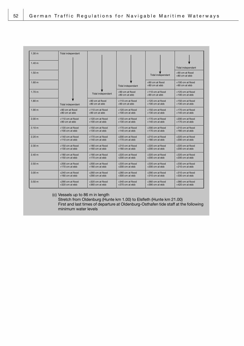
52 G e r m a n T r a f f i c R e g u l a t i o n s f o r N a v i g a b l e M a r i t i m e W a t e r w a y s
1.30 m Tidal independant
Tidal independant
Tidal independant
Tidal independant
Tidal independant
Tidal independant
1.40 m
1.50 m +90 cm at flood+80 cm at ebb
1.60 m +90 cm at flood+80 cm at ebb
+100 cm at flood+90 cm at ebb
1.70 m +90 cm at flood+80 cm at ebb
+110 cm at flood+90 cm at ebb
+120 cm at flood+100 cm at ebb
1.80 m +90 cm at flood+80 cm at ebb
+110 cm at flood+90 cm at ebb
+120 cm at flood+100 cm at ebb
+150 cm at flood+130 cm at ebb
1.90 m +90 cm at flood+80 cm at ebb
+110 cm at flood+90 cm at ebb
+120 cm at flood+100 cm at ebb
+150 cm at flood+130 cm at ebb
+170 cm at flood+140 cm at ebb
2.00 m +110 cm at flood+90 cm at ebb
+120 cm at flood+100 cm at ebb
+150 cm at flood+130 cm at ebb
+170 cm at flood+140 cm at ebb
+200 cm at flood+170 cm at ebb
2.10 m +120 cm at flood+100 cm at ebb
+150 cm at flood+130 cm at ebb
+170 cm at flood+140 cm at ebb
+200 cm at flood+170 cm at ebb
+210 cm at flood +180 cm at ebb
2.20 m +140 cm at flood+110 cm at ebb
+170 cm at flood+140 cm at ebb
+200 cm at flood +170 cm at ebb
+210 cm at flood +180 cm at ebb
+220 cm at flood +200 cm at ebb
2.30 m +150 cm at flood+130 cm at ebb
+180 cm at flood +160 cm at ebb
+210 cm at flood +180 cm at ebb
+220 cm at flood +200 cm at ebb
+220 cm at flood +200 cm at ebb
2.40 m +180 cm at flood +150 cm at ebb
+190 cm at flood +170 cm at ebb
+220 cm at flood +200 cm at ebb
+220 cm at flood +200 cm at ebb
+220 cm at flood +200 cm at ebb
2.50 m +200 cm at flood +170 cm at ebb
+200 cm at flood +180 cm at ebb
+220 cm at flood +200 cm at ebb
+220 cm at flood +200 cm at ebb
+230 cm at flood +210 cm at ebb
3.00 m +240 cm at flood +160 cm at ebb
+260 cm at flood +290 cm at ebb
+280 cm at flood +300 cm at ebb
+290 cm at flood +310 cm at ebb
+310 cm at flood +330 cm at ebb
3.50 m +290 cm at flood+320 cm at ebb
+320 cm at flood+360 cm at ebb
+340 cm at flood +370 cm at ebb
+360 cm at flood +390 cm at ebb
+380 cm at flood +420 cm at ebb
(c) Vessels up to 86 m in length Stretch from Oldenburg (Hunte km 1.00) to Elsfleth (Hunte km 21.00) First and last times of departure at Oldenburg-Osthafen tide staff at the following
minimum water levels

G e r m a n T r a f f i c R e g u l a t i o n s f o r N a v i g a b l e M a r i t i m e W a t e r w a y s 53
Draught up to Beam in metres
up to 7.00 m up to 7.50 m up to 8.00 m up to 8.50 m up to 9.50 m up to 10.50 m
1.30 m Tidal independant
Tidal independant
Tidal independant
Tidal independant Tidal independant
Tidal independant
Tidal independant
1.40 m
1.50 m
1.60 m +80 cm at ebb+210 cm at ebb
1.70 m +80 cm at ebb+190 cm at ebb
+80 cm at ebb+220 cm at ebb
1.80 m +80 cm at ebb+200 cm at ebb
+80 cm at ebb+230 cm at ebb
1.90 m +80 cm at ebb+190 cm at ebb
+80 cm at ebb+190 cm at ebb
+80 cm at ebb+210 cm at ebb
+70 cm at ebb+240 cm at ebb
2.00 m +80 cm at ebb+190 cm at ebb
+80 cm at ebb+200 cm at ebb
+80 cm at ebb+200 cm at ebb
+70 cm at ebb+230 cm at ebb
+70 cm at ebb+260 cm at ebb
2.10 m +80 cm at ebb+190 cm at ebb
+80 cm at ebb+200 cm at ebb
+80 cm at ebb+210 cm at ebb
+80 cm at ebb+210 cm at ebb
+70 cm at ebb +240 cm at ebb
+60 cm at ebb +270 cm at ebb
2.20 m +80 cm at ebb+200 cm at ebb
+80 cm at ebb+200 cm at ebb
+70 cm at ebb+210 cm at ebb
+60 cm at ebb+220 cm at ebb
+60 cm at ebb +250 cm at ebb
+60 cm at ebb +270 cm at ebb
2.30 m +70 cm at ebb+200 cm at ebb
+70 cm at ebb+200 cm at ebb
+70 cm at ebb+220 cm at ebb
+60 cm at ebb +230 cm at ebb
+60 cm at ebb +250 cm at ebb
+50 cm at ebb+280 cm at ebb
2.40 m +70 cm at ebb+210 cm at ebb
+70 cm at ebb +220 cm at ebb
+70 cm at ebb +230 cm at ebb
+60 cm at ebb +240 cm at ebb
+50 cm at ebb+260 cm at ebb
+50 cm at ebb +290 cm at HW
2.50 m +60 cm at ebb +210 cm at ebb
+60 cm at ebb +230 cm at ebb
+60 cm at ebb+240 cm at ebb
+60 cm at ebb +250 cm at ebb
+50 cm at ebb+270 cm at ebb
+50 cm at ebb+290 cm at HW
3.00 m +70 cm at flood +250 cm at flood
+70 cm at flood +250 cm at flood
+70 cm at flood +250 cm at flood
+90 cm at flood +250 cm at flood
+90 cm at flood +250 cm at flood
+90 cm at flood +250 cm at flood
3.50 m +130 cm at flood +250 cm at flood
+130 cm at flood +250 cm at flood
+130 cm at flood +250 cm at flood
4.00 m +160 cm at flood +250 cm at flood
+160 cm at flood +250 cm at flood
4.20 m +180 cm at flood +250 cm at flood
+180 cm at flood +250 cm at flood
(d) Inland waterway vessels of 86 m up to 100 m in length Stretch from Oldenburg (Hunte km 1.00) to Elsfleth (Hunte km 21.00) First and last times of departure at Oldenburg-Osthafen tide staff at the following
minimum water levels

54 G e r m a n T r a f f i c R e g u l a t i o n s f o r N a v i g a b l e M a r i t i m e W a t e r w a y s
Draught up to Beam in metres
up to 8.50 m up to 9.00 m up to 9.50 m up to 10.00 m up to 10.50 m
1.30 m Tidal independant
Tidal independant
Tidal independant
Tidal independant
Tidal independant
Tidal independant1.40 m
1.50 m +80 cm at ebb+250 cm at flood
1.60 m +80 cm at ebb+250 cm at flood
+70 cm at ebb+250 cm at flood
1.70 m +80 cm at ebb+250 cm at flood
+70 cm at ebb+250 cm at flood
+70 cm at ebb+250 cm at flood
1.80 m +80 cm at ebb+250 cm at flood
+70 cm at ebb+250 cm at flood
+70 cm at ebb+250 cm at flood
+60 cm at ebb+250 cm at flood
1.90 m +80 cm at ebb+250 cm at flood
+70 cm at ebb+250 cm at flood
+70 cm at ebb+250 cm at flood
+60 cm at ebb+250 cm at flood
+60 cm at ebb+250 cm at flood
2.00 m +70 cm at ebb+250 cm at flood
+70 cm at ebb+250 cm at flood
+60 cm at ebb+250 cm at flood
+60 cm at ebb+250 cm at flood
+60 cm at ebb+250 cm at flood
2.10 m +70 cm at ebb+250 cm at flood
+60 cm at ebb+250 cm at flood
+60 cm at ebb+250 cm at flood
+50 cm at ebb+250 cm at flood
+40 cm bei MLW+250 cm at flood
2.20 m +60 cm at ebb+250 cm at flood
+60 cm at ebb+250 cm at flood
+60 cm at ebb+250 cm at flood
+40 cm bei MLW+250 cm at flood
+50 cm at flood+250 cm at flood
2.30 m +60 cm at ebb+250 cm at flood
+60 cm at ebb+250 cm at flood
+40 cm bei MLW+250 cm at flood
+50 cm at flood +250 cm at flood
+50 cm at flood +250 cm at flood
2.40 m +60 cm at ebb+250 cm at flood
+50 cm at ebb+250 cm at flood
+50 cm at flood +250 cm at flood
+50 cm at flood +250 cm at flood
+50 cm at flood +250 cm at flood
2.50 m +50 cm at ebb +250 cm at flood
+50 cm at flood +250 cm at flood
+50 cm at flood +250 cm at flood
+50 cm at flood +250 cm at flood
+50 cm at flood +250 cm at flood
3.00 m +80 cm at flood +250 cm at flood
+90 cm at flood +250 cm at flood
+90 cm at flood +250 cm at flood
+90 cm at flood +250 cm at flood
+90 cm at flood +250 cm at flood
3.50 m +110 cm at flood+250 cm at flood
+110 cm at flood+250 cm at flood
+110 cm at flood +250 cm at flood
+110 cm at flood +250 cm at flood
+110 cm at flood +250 cm at flood
e) Prohibition of night navigation: In the stretch between Osthafen Oldenburg (km 2.8) and the Elsfleth-Ohrt railway
bridge (km 20.8), outbound traffic on the river Hunte is only allowed from two hours before sunrise to two hours after sunset (in poor visibility of less than 1.000 m: from one hour before sunrise to one hour after sunset).
Exceptions from the prohibition of night navigation: Inland waterway vessels having a maximum draught of 2.50 m which are fitted
with an operational radar system and a rate-of-turn indicator are also allowed to navigate by night at the following water levels:
First departure time: + 50 cm at flood tide Last departure time: +230 cm at flood tide
f) In the stretch between Osthafen Oldenburg (km 2.8) and Reithörne (km 8.0). navigation is only allowed at water levels up to maximally Chart Datum + 3.70 m at the Osthafen and Reithörne tide staffs.
11.3 From Buoy 51, incoming vessels bound for Bremerhaven whose draught exceeds 12.80 m are required to accept escort tugs having a design bollard pull of at least 40 tons. It must be possible at any time to make a tow connection.

G e r m a n T r a f f i c R e g u l a t i o n s f o r N a v i g a b l e M a r i t i m e W a t e r w a y s 55
14 Notice of the Federal Waterways and Shipping Agency – Northern Region Office
14.1 Husumer Au
14.1.1 Vessels with a length of 9.00 m and above, or with a draught of 3.40 m and above, are not allowed to enter the Husumer Au unless the range of visibility prevailing is 1000 m or more. Vessels carrying a sea pilot are exempted from this regulation.
14.1.2 All vessels within the description under Item 14.1.1 shall obtain consent to enter the Husumer Au in good time before passing Buoy 61 by applying to Husum Port coas-tal radio station via VHF channel 11.
14.2 River Elbe
14.2.1 Maximum draughts and tide windows
14.2.1.1 Distance Sea–Hamburg–Sea
14.2.1.1.1 Maximum draughts (freshwater) for the approach from the open sea into the Port of Hamburg and vice versa in assumed normal tidal and fairway conditions
14.2.1.1.1 Höchsttiefgänge auf der Elbe für die Fahrtstrecke See–Hamburg–See unter der
Voraussetzung normaler Tide- und Fahrwasserverhältnisse
Containerships Independant of the tide(m) Dependent of the tideoutbound (m)
Dependent of the tideinbound (m)
Beam up to 32.3 m or length up to 330 m
12.80 13.80 15.10
Beam up to 45.0 m or length up to 340 m
12.70 13.80 15.10
Beam up to 47.5 m or length up to 360 m
12.60 13.50 14.90
Beam up to 50.0 m or length up to 370 m
12.40 13.30 14.70
Beam up to 52.5 m or length up to 380 m
12.20 13.00 14.50
Beam up to 55.0 m or length up to 390 m
12.00 12.80 14.30
Beam up to 57.5 m or length up to 400 m
11.80 12.60 14.10
Beam up to 60.0 m or length up to 400 m
11.60 12.40 13.90
All other vessels (Bulk carrier, Passenger ships, …)
Beam up to 45.0 m or length up to 330 m
12.80 13.80 15.10
Beam up to 50.0 m or length up to 340 m
12.60 13.50 14.90
Beam up to 55.0 m or length up to 350 m
12.40 13.30 14.70
Beam up to 63.0 m or length up to 360 m
12.20 13.00 14.50
14.2.1.1.2 Tidefenster für die Fahrtstrecke See–Hamburg–See unter der Voraussetzung normaler Tide- und Fahrwasserverhältnisse
Containerships
inbound Independant of the
tide
Dependant of the tide
(departure window for passage Großer Vogelsand related to tidal low water Cuxhaven)
Fresh water draughts up to 11.80 m 12.00 m 12.20 m 12.40 m 12.60 m 12.80 m 13.00 m 13.20 m 13.40 m 13.60 m 13.80 m 13.90 m 14.00 m
Beam up to 32,3 m or
length up to 330 m
12.80 m tideunabhängig
–0:25
–5:35
–0:25
–5:35
–0:05
–6:15
0:10
–6:15
0:25
–6:50
0:40
–6:50
0:40
–6:50
Beam up to 45 m or
length up to 340 m
12.70 m tideunabhängig
–0:20
–5:35
–0:20
–5:35
–0:20
–5:35
0:00
–6:15
0:15
–6:15
0:30
–6:50
0:45
–6:50
0:45
–6:50
Beam up to 47.5 m or
length up to 360 m
12.60 m tideunabhängig
–0:20
–5:35
–0:20
–5:35
0:00
–6:15
0:15
–6:15
0:30
–6:50
0:45
–6:50
1:00
5:15
1:00
5:15
Beam up to 50 m or
length up to 370 m
12.40 m tideunabhängig
–0:20
–5:35
–0:20
–5:35
0:00
–6:15
0:15
–6:15
0:30
–6:50
0:45
–6:50
1:00
5:15
1:15
5:15
1:15
5:15
Beam up to 52.5 m or
length up to 380 m
12.20 m tideunabhängig
–0:20
–5:35
–0:20
–5:35
0:00
–6:15
0:15
–6:15
0:30
–6:50
0:45
–6:50
1:00
5:15
1:15
5:15
1:35
4:55
1:35
4:55
Beam up to 55 m or
length up to 390 m
12.00 m tideunabhängig
–0:20
–5:35
–0:20
–5:35
0:00
–6:15
0:15
–6:15
0:30
–6:50
0:45
–6:50
1:00
5:15
1:15
5:15
1:35
4:55
1:55
4:55
1:55
4:55
Beam up to 57.5 m or
length up to 400 m
11.80 m tideun-
abhängig
–0:20
–5:35
–0:20
–5:35
0:00
–6:15
0:15
–6:15
0:30
–6:50
0:45
–6:50
1:00
5:15
1:15
5:15
1:35
4:55
1:55
4:55
2:30
3:05
2:30
3:05
Beam up to 60 m or
length up to 400 m
11.60 m –0:20
–5:35
–0:20
–5:35
0:00
–6:15
0:15
–6:15
0:30
–6:50
0:45
–6:50
1:00
5:15
1:15
5:15
1:35
4:55
1:55
4:55
2:30
3:05
2:30
3:05
No interpolation
Containerships (cont.)
inbound Independant of the
tide
Dependant of the tide
(departure window for passage Großer Vogelsand related to tidal low water Cuxhaven)

56 G e r m a n T r a f f i c R e g u l a t i o n s f o r N a v i g a b l e M a r i t i m e W a t e r w a y s
14.2.1.1.2 Tide window for the distance Sea–Hamburg–Sea in aussumed normal tidal and fair-way conditions
14.2.1.1.1 Höchsttiefgänge auf der Elbe für die Fahrtstrecke See–Hamburg–See unter der
Voraussetzung normaler Tide- und Fahrwasserverhältnisse
Containerships Independant of the tide(m) Dependent of the tideoutbound (m)
Dependent of the tideinbound (m)
Beam up to 32.3 m or length up to 330 m
12.80 13.80 15.10
Beam up to 45.0 m or length up to 340 m
12.70 13.80 15.10
Beam up to 47.5 m or length up to 360 m
12.60 13.50 14.90
Beam up to 50.0 m or length up to 370 m
12.40 13.30 14.70
Beam up to 52.5 m or length up to 380 m
12.20 13.00 14.50
Beam up to 55.0 m or length up to 390 m
12.00 12.80 14.30
Beam up to 57.5 m or length up to 400 m
11.80 12.60 14.10
Beam up to 60.0 m or length up to 400 m
11.60 12.40 13.90
All other vessels (Bulk carrier, Passenger ships, …)
Beam up to 45.0 m or length up to 330 m
12.80 13.80 15.10
Beam up to 50.0 m or length up to 340 m
12.60 13.50 14.90
Beam up to 55.0 m or length up to 350 m
12.40 13.30 14.70
Beam up to 63.0 m or length up to 360 m
12.20 13.00 14.50
14.2.1.1.2 Tidefenster für die Fahrtstrecke See–Hamburg–See unter der Voraussetzung normaler Tide- und Fahrwasserverhältnisse
Containerships
inbound Independant of the
tide
Dependant of the tide
(departure window for passage Großer Vogelsand related to tidal low water Cuxhaven)
Fresh water draughts up to 11.80 m 12.00 m 12.20 m 12.40 m 12.60 m 12.80 m 13.00 m 13.20 m 13.40 m 13.60 m 13.80 m 13.90 m 14.00 m
Beam up to 32,3 m or
length up to 330 m
12.80 m tideunabhängig
–0:25
–5:35
–0:25
–5:35
–0:05
–6:15
0:10
–6:15
0:25
–6:50
0:40
–6:50
0:40
–6:50
Beam up to 45 m or
length up to 340 m
12.70 m tideunabhängig
–0:20
–5:35
–0:20
–5:35
–0:20
–5:35
0:00
–6:15
0:15
–6:15
0:30
–6:50
0:45
–6:50
0:45
–6:50
Beam up to 47.5 m or
length up to 360 m
12.60 m tideunabhängig
–0:20
–5:35
–0:20
–5:35
0:00
–6:15
0:15
–6:15
0:30
–6:50
0:45
–6:50
1:00
5:15
1:00
5:15
Beam up to 50 m or
length up to 370 m
12.40 m tideunabhängig
–0:20
–5:35
–0:20
–5:35
0:00
–6:15
0:15
–6:15
0:30
–6:50
0:45
–6:50
1:00
5:15
1:15
5:15
1:15
5:15
Beam up to 52.5 m or
length up to 380 m
12.20 m tideunabhängig
–0:20
–5:35
–0:20
–5:35
0:00
–6:15
0:15
–6:15
0:30
–6:50
0:45
–6:50
1:00
5:15
1:15
5:15
1:35
4:55
1:35
4:55
Beam up to 55 m or
length up to 390 m
12.00 m tideunabhängig
–0:20
–5:35
–0:20
–5:35
0:00
–6:15
0:15
–6:15
0:30
–6:50
0:45
–6:50
1:00
5:15
1:15
5:15
1:35
4:55
1:55
4:55
1:55
4:55
Beam up to 57.5 m or
length up to 400 m
11.80 m tideun-
abhängig
–0:20
–5:35
–0:20
–5:35
0:00
–6:15
0:15
–6:15
0:30
–6:50
0:45
–6:50
1:00
5:15
1:15
5:15
1:35
4:55
1:55
4:55
2:30
3:05
2:30
3:05
Beam up to 60 m or
length up to 400 m
11.60 m –0:20
–5:35
–0:20
–5:35
0:00
–6:15
0:15
–6:15
0:30
–6:50
0:45
–6:50
1:00
5:15
1:15
5:15
1:35
4:55
1:55
4:55
2:30
3:05
2:30
3:05
No interpolation
Containerships (cont.)
inbound Independant of the
tide
Dependant of the tide
(departure window for passage Großer Vogelsand related to tidal low water Cuxhaven)
Containerships (cont.)
inbound Independant of the
tide
Dependant of the tide
(departure window for passage Großer Vogelsand related to tidal low water Cuxhaven)
Fresh water draughts up to 14.10 m 14.20 m 14.30 m 14.40 m 14.50 m 14.60 m 14.70 m 14.80 m 14.90 m 15.10 m
Beam up to 32.3 m or
length up to 330 m
12.80 m 0:55
5:15
0:55
5:15
1:10
5:15
1:10
5:15
1:30
4:55
1:30
4:55
1:45
4:55
1:45
4:55
2:20
3:05
2:20
3:05
Beam up to 45 m or
length up to 340 m
12.70 m 1:00
5:15
1:00
5:15
1:15
5:15
1:15
5:15
1:35
4:55
1:35
4:55
1:55
4:55
1:55
4:55
2:30
3:05
2:30
3:05
Beam up to 47.5 m or
length up to 360 m
12.60 m 1:15
5:15
1:15
5:15
1:35
4:55
1:35
4:55
1:55
4:55
1:55
4:55
2:30
3:05
2:30
3:05
2:30
3:05
Beam up to 50 m or
length up to 370 m
12.40 m 1:35
4:55
1:35
4:55
1:55
4:55
1:55
4:55
2:30
3:05
2:30
3:05
2:30
3:05
Beam up to 52.5 m or
length up to 380 m
12.20 m 1:55
4:55
1:55
4:55
2:30
3:05
2:30
3:05
2:30
3:05
Beam up to 55 m or
length up to 390 m
12.00 m 2:30
3:05
2:30
3:05
2:30
3:05
Beam up to 57.5 m or
length up to 400 m
11.80 m 2:30
3:05
Beam up to 60 m or
length up to 400 m
11.60 m
No interpolation
Container ships
outbound Independant of the
tide
Dependant of the tide
(departure window for passage Seemannshöft related to tidal low water St. Pauli)
Fresh water draughts up to 11.80 m 12.00 m 12.20 m 12.40 m 12.60 m 12.80 m 13.00 m 13.20 m 13.30 m 13.40 m 13.50 m 13.60 m 13.80 m
Beam up to 32.3 m or
length up to 330 m
12.80 m Independant of the tide
–1:00
3:25
–0:55
2:50
–0:45
2:10
–0:45
2:10
–0:40
1:30
–0:40
1:30
–0:30
0:50
Beam up to 45 m or
length up to 340 m
12.70 m Independant of the tide
–0:55
2:55
–0:55
2:55
–0:45
2:20
–0:40
1:35
–0:40
1:35
–0:30
1:00
–0:30
1:00
–0:15
0:20
Beam up to 47.5 m or
length up to 360 m
12.60 m Independant of the tide
–0:55
2:55
–0:45
2:20
–0:40
1:35
–0:30
1:00
–0:30
1:00
–0:15
0:20
Beam up to 50 m or
length up to 370 m
12.40 m Independant of the tide
–0:55
2:55
–0:45
2:20
–0:40
1:35
–0:30
1:00
–0:15
0:20
Beam up to 52.5 m or
length up to 380 m
12.20 m Independant of the tide
–0:55
2:55
–0:45
2:20
–0:40
1:35
–0:30
1:00
Beam up to 55 m or
length up to 390 m
12.00 m Independant of the tide
–0:55
2:55
–0:45
2:20
–0:40
1:35
–0:30
1:00
Beam up to 5.,5 m or
length up to 400 m
11.80 m Independant of the tide
–0:55
2:55
–0:45
2:20
–0:40
1:35
–0:30
1:00
Beam up to 60 m or
length up to 400 m
11.60 m –0:55
2:55
–0:45
2:20
–0:40
1:35
–0:30
1:00
No interpolation
All other vessesls
inbound Independant of the
tide
Dependant of the tide
(departure window for passage Großer Vogelsand related to tidal low water Cuxhaven)
Fresh water draughts up to 12.40 m 12.60 m 12.80 m 13.00 m 13.20 m 13.40 m 13.60 m 13.80 m 14.00 m 14.20 m 14.40 m 14.50 m 14.60 m
Beam up to 45 m or
length up to 330 m
12.80 m Independant of the tide
–1:10
–6:15
–1:10
–6:15
–0:45
–6:50
–0:20
–6:50
0:00
5:00
0:15
5:00
0:30
4:45
0:45
4:45
1:05
4:25
1:05
4:25
Beam up to 50 m or
length up to 340 m
12.60 m Independant of the tide
–1:10
–6:15
–1:10
–6:15
–0:20
–6:50
–0:20
–6:50
0:15
5:00
0:15
5:00
0:45
4:45
0:45
4:45
1:20
4:25
1:20
4:25
1:20
4:25
Beam up to 55 m or
length up to 350 m
12.40 m Independ
ant of the
tide
–1:10
–6:15
–1:10
–6:15
–0:20
–6:50
–0:20
–6:50
0:15
5:00
0:15
5:00
0:45
4:45
0:45
4:45
1:20
4:25
1:20
4:25
1:55
2:40
1:55
2:40
Beam up to 63 m or
length up to 360 m
12.20 m –1:10
–6:15
–1:10
–6:15
–0:20
–6:50
–0:20
–6:50
0:15
5:00
0:15
5:00
0:45
4:45
0:45
4:45
1:20
4:25
1:20
4:25
1:55
2:40
1:55
2:40
No interpolation

G e r m a n T r a f f i c R e g u l a t i o n s f o r N a v i g a b l e M a r i t i m e W a t e r w a y s 57
Containerships (cont.)
inbound Independant of the
tide
Dependant of the tide
(departure window for passage Großer Vogelsand related to tidal low water Cuxhaven)
Fresh water draughts up to 14.10 m 14.20 m 14.30 m 14.40 m 14.50 m 14.60 m 14.70 m 14.80 m 14.90 m 15.10 m
Beam up to 32.3 m or
length up to 330 m
12.80 m 0:55
5:15
0:55
5:15
1:10
5:15
1:10
5:15
1:30
4:55
1:30
4:55
1:45
4:55
1:45
4:55
2:20
3:05
2:20
3:05
Beam up to 45 m or
length up to 340 m
12.70 m 1:00
5:15
1:00
5:15
1:15
5:15
1:15
5:15
1:35
4:55
1:35
4:55
1:55
4:55
1:55
4:55
2:30
3:05
2:30
3:05
Beam up to 47.5 m or
length up to 360 m
12.60 m 1:15
5:15
1:15
5:15
1:35
4:55
1:35
4:55
1:55
4:55
1:55
4:55
2:30
3:05
2:30
3:05
2:30
3:05
Beam up to 50 m or
length up to 370 m
12.40 m 1:35
4:55
1:35
4:55
1:55
4:55
1:55
4:55
2:30
3:05
2:30
3:05
2:30
3:05
Beam up to 52.5 m or
length up to 380 m
12.20 m 1:55
4:55
1:55
4:55
2:30
3:05
2:30
3:05
2:30
3:05
Beam up to 55 m or
length up to 390 m
12.00 m 2:30
3:05
2:30
3:05
2:30
3:05
Beam up to 57.5 m or
length up to 400 m
11.80 m 2:30
3:05
Beam up to 60 m or
length up to 400 m
11.60 m
No interpolation
Container ships
outbound Independant of the
tide
Dependant of the tide
(departure window for passage Seemannshöft related to tidal low water St. Pauli)
Fresh water draughts up to 11.80 m 12.00 m 12.20 m 12.40 m 12.60 m 12.80 m 13.00 m 13.20 m 13.30 m 13.40 m 13.50 m 13.60 m 13.80 m
Beam up to 32.3 m or
length up to 330 m
12.80 m Independant of the tide
–1:00
3:25
–0:55
2:50
–0:45
2:10
–0:45
2:10
–0:40
1:30
–0:40
1:30
–0:30
0:50
Beam up to 45 m or
length up to 340 m
12.70 m Independant of the tide
–0:55
2:55
–0:55
2:55
–0:45
2:20
–0:40
1:35
–0:40
1:35
–0:30
1:00
–0:30
1:00
–0:15
0:20
Beam up to 47.5 m or
length up to 360 m
12.60 m Independant of the tide
–0:55
2:55
–0:45
2:20
–0:40
1:35
–0:30
1:00
–0:30
1:00
–0:15
0:20
Beam up to 50 m or
length up to 370 m
12.40 m Independant of the tide
–0:55
2:55
–0:45
2:20
–0:40
1:35
–0:30
1:00
–0:15
0:20
Beam up to 52.5 m or
length up to 380 m
12.20 m Independant of the tide
–0:55
2:55
–0:45
2:20
–0:40
1:35
–0:30
1:00
Beam up to 55 m or
length up to 390 m
12.00 m Independant of the tide
–0:55
2:55
–0:45
2:20
–0:40
1:35
–0:30
1:00
Beam up to 5.,5 m or
length up to 400 m
11.80 m Independant of the tide
–0:55
2:55
–0:45
2:20
–0:40
1:35
–0:30
1:00
Beam up to 60 m or
length up to 400 m
11.60 m –0:55
2:55
–0:45
2:20
–0:40
1:35
–0:30
1:00
No interpolation
All other vessesls
inbound Independant of the
tide
Dependant of the tide
(departure window for passage Großer Vogelsand related to tidal low water Cuxhaven)
Fresh water draughts up to 12.40 m 12.60 m 12.80 m 13.00 m 13.20 m 13.40 m 13.60 m 13.80 m 14.00 m 14.20 m 14.40 m 14.50 m 14.60 m
Beam up to 45 m or
length up to 330 m
12.80 m Independant of the tide
–1:10
–6:15
–1:10
–6:15
–0:45
–6:50
–0:20
–6:50
0:00
5:00
0:15
5:00
0:30
4:45
0:45
4:45
1:05
4:25
1:05
4:25
Beam up to 50 m or
length up to 340 m
12.60 m Independant of the tide
–1:10
–6:15
–1:10
–6:15
–0:20
–6:50
–0:20
–6:50
0:15
5:00
0:15
5:00
0:45
4:45
0:45
4:45
1:20
4:25
1:20
4:25
1:20
4:25
Beam up to 55 m or
length up to 350 m
12.40 m Independ
ant of the
tide
–1:10
–6:15
–1:10
–6:15
–0:20
–6:50
–0:20
–6:50
0:15
5:00
0:15
5:00
0:45
4:45
0:45
4:45
1:20
4:25
1:20
4:25
1:55
2:40
1:55
2:40
Beam up to 63 m or
length up to 360 m
12.20 m –1:10
–6:15
–1:10
–6:15
–0:20
–6:50
–0:20
–6:50
0:15
5:00
0:15
5:00
0:45
4:45
0:45
4:45
1:20
4:25
1:20
4:25
1:55
2:40
1:55
2:40
No interpolation

58 G e r m a n T r a f f i c R e g u l a t i o n s f o r N a v i g a b l e M a r i t i m e W a t e r w a y s
14.2.1.2 Distance Sea–Brunsbüttel “Elbehafen”-Sea
14.2.1.2.1 Maximum draughts (freshwater tide windows) for the approach from the open sea into the Brunsbüttel “Elbehafen” harbour and vice versa assuming normal tidal fair-way conditions on the river Elbe and in the approaches to “Nordostreede” Roads abreast the Elbe Port (chart datum (LAT) – 13.95 m)
Navigation is independent of the tide (inbound and outbound traffic for all berth areas)
Freshwater draught up to 12.80 m, except all laden gas tankers
Navigation is dependent on the tide
Outbound traffic (departure window in relation to Brunsbüttel tidal low water)
Freshwater draughts
up to 13.20 m up to 13.60 m up to 13.80 m up to 14.00 m up to 14.40 m up to 14.80 m
Tanker unloadingberth area
+1:15–4:15
+1:35–5:20
+1:45–5:45
General cargoberth area
+1:15–4:15
+1:35–5:20
+1:45–5:45
+2:00–6:15
+2:30+5:15
+3:15+4:30
Navigation is dependent on the tide
Inbound traffic (arrival window in relation to Brunsbüttel tidal low water)
all laden gas tankers independent of the draught must berth at peak-water times or against the tidal current
Freshwaterdraughts
up to 13.20 m
up to 13.60 m
up to 13.80 m
up to 14.00 m
up to 14.40 m
up to 14.80 m
up to 14.80 m0.40 m
allowance
up to 14.80 m0.80 m
allowance
Tanker unloa-dingberth area
+0:55–2:15
+1:15–3:15
+1.25–3:30
General cargoberth area
+0:55–2:15
+1:15–3:15
+1:35–3:50
+2:00–4:35
+2:30–5:25
+3:15–6:05
+4:25+5:20
The suitable point in time for the berthing within the tidal window is determined in arrangement between the captain and the pilot.
14.2.1.3 In cases where either the length or the beam specified for a particular vessel cate-gory in Item 14.2.1.1.1 above are exceeded, the one vessel category shall apply that will accommodate both length and beam of the vessel in question.
14.2.2 Navigation bans and restrictions to navigation applying on the stretch of water bet-ween the River Stör estuary/Rhinplatte North (Buoys 75/76) and the Hamburg City Limit off Tinsdal (Buoy 125)
14.2.2.1 Two vessels with an aggregate beam of 90.00 m and above who are both constrai-ned by their draught to take the deep-draught channel shall not be permitted to be involved in an overtaking or head-on situation on the stretch of water specified in Item 14.2.2 above. The Brunsbüttel Vessel Traffic Centre may grant exemptions from this restriction, having regard to both vessels’ current draught and to the water height at the calculated time of overtaking, respectively, of passing each other.
14.2.2.2 The competent authority for issuing shipping police orders embodying navigation bans and restrictions to navigation under the provisions of Section 56(1) SeeSchStrO for the stretch of water specified in Item 14.2.2 above is the Brunsbüttel Vessel Traffic Centre, who may enlist the services of the Hamburg Nautical Centre (“Nautische Zentrale Hamburg”) and of the Cuxhaven Vessel Traffic Centre for the transmission of shipping police orders.

G e r m a n T r a f f i c R e g u l a t i o n s f o r N a v i g a b l e M a r i t i m e W a t e r w a y s 59
14.2.3 For the purposes of entering the waterway and for leaving a port/berth, the compe-tent Vessel Traffic centre may grant individual exemptions from the navigation ban in terms of Section 30(2)(Item 1) SeeSchStrO to tankers and composite units in terms of Section 30(1) SeeSchStrO with a deadweight capacity of more than 2000 metric tonnes, even if the range of visibility is less than 1000 m; any such exemptions may only be granted when each and all of the following prerequisites are met:
– The range of visibility shall be more than 500 m. – The traffic situation shall be such as to allow for granting such an exemption. – The tanker’s or composite unit’s length overall shall not exceed 140.00 m, while
her draught shall not exceed 8.50 m. – Nothing goes to indicate any deficiencies or shortcomings as o the tanker’s or
composite unit’s equipment and technical features.14.2.4 Prerequisites to be met by tankers in terms of Section 30(1)(Items 1 and 2) See-
SchStrO prior to berthing in the West part of the “Brunsbüttel Elbehafen” Port and in the South part of the jetty off Bützfleth are those specified below:
14.2.4.1 Brunsbüttel Elbehafen port, West part Tankers in terms of item 1a of Section 30(1) of the Traffic Regulations for Navigable
Maritime Waterways (SeeSchStrO) shall make arrangements to ensure that they will berth against the direction of the titdal current. If, owing to delays when navigating through the district or other unforeseeable events, this requirement cannot be met, every effort shall be made to avoid making a turning circle anywhere to the East of the Elbehafen port; this may be done, e. g. by enlisting tug assistance beyound the original extent.
14.2.4.2 South part of the jetty off Bützfleth
14.2.4.2.1 Tankers in terms of Items 1a and c and of Item 2 of Section 30(1) SeeSchStrO shall be permitted to berth in the South part of the jetty off Bützfleth only upon meeting the following prerequisites:
(a) Inside edge of the Elbanleger terminal: Neither the maximum permitted overall length of 155.00 m nor the maximum
permitted beam of 33.00 m shall be exceeded. However, the maximum permit-ted beam of 28 m shall not be exceeded when a vessel with a beam in excess of 28.00 m is berthed at the shoreside terminal in the inner South harbour basin.
(b) Outside edge of the Elbanleger terminal: The maximum permitted length overall of 270.00 m shall not be exceeded. (c) Shoreside terminal in the inner South harbour basin: Neither the maximum permitted length overall of 200.00 m nor the maximum
permitted beam of 33.00 m shall be exceeded.
14.2.4.2.2 Vessels within the description of Item 14.2.4.2.1 above shall report not later than 72 hours before arrival (or, when being underway less than 72 hours, not later than when leaving their last port of call) to the Brunsbüttel Vessel Traffic Centre (tele-phone: + 49 48 52 / 88 53 93 or 84 00, facsimile: + 49 48 52 8 73 88).
14.2.4.2.3 Vessels of the types referred to in Items 14.2.4.2.1(a) and (b) above shall berth so as to have their bows pointing towards the exit of the jetty. Taking into account the water level predicted by the Federal Maritime and Hydrographic Agency, vessels shall have a minimum under-keel clearance of 1.00 m at their respective berth. In any case, the draught may not exceed 9.00 m.

60 G e r m a n T r a f f i c R e g u l a t i o n s f o r N a v i g a b l e M a r i t i m e W a t e r w a y s
14.2.4.2.4 Tug assistance as specified below shall be enlisted for berthing and for leaving berth at the terminals listed in Item 14.2.4.2.1(a) and (c) above:
For berthing: – Vessels with a length of up to 155.00 m shall enlist the assistance of two tugs with
a bollard pull of 25 tonnes each. – Vessels with a length between 155.00 m and 200.00 m shall enlist the assistance
of three tugs with a bollard pull of 35 tonnes each. – Vessels with a length between 160.00 m and 200.00 m shall enlist the assistance
of three tugs with a bollard pull of 35 tonnes each. By way of exception: – vessels with a length of up to 90.00 m fitted with an operational bow thruster may
enlist the assistance of only one tug with a bollard pull of only 20 tonnes.
For leaving berth: Weather conditions permitting, the assistance of one tug less than required for
berthing may be enlisted for leaving berth.
Berthing and leaving berth is prohibited for vessels with a length of 160.00 m and above when wind force is above 6 Bft.
14.2.4.2.5 Vessels covered by the provisions of Item 14.2.4.2.1(b) shall enlist sufficient tug assistance. This applies to vessels with a length of less than 120.00 m fitted with an operational bow thruster and to other vessels with a length of less than 100.00 m only when circumstances so require; such circumstances include, without being restricted thereto, difficulties in berthing manœuvres, the presence of floating ice, and unfavourable weather conditions.
14.2.4.2.6 The enlistment of sufficient tug assistance as specified in Item 14.2.4.2.4 and 14.2.4.2.5 also applies for tankers with cleaned and de-gassed or completely iner-ted tanks.
14.2.5 Shipping police authority prerequisites for navigating the Elbe River with inland waterway vessels
14.2.5.1 Downstream from Glückstadt, inland vessels having less than 1.30 m freeboard are required to navigate with closed hatches (waterline to upper coaming edge).
14.2.5.2 Inland waterway vessesls that must transport containers according to the Inland Vessels (Surveys and Certification) Ordinance (BinSchUO):
a) In the navigation area between Tinsdal and Glückstadt: Secure the containers if loaded in stacks of more than two layers.
b) In the navigation area between Glückstadt and Cuxhaven: Secure the containers if stacked in more than one leyer. A container load is only considered secure when the individual containers are firmly bound to the ship’s hull using guide rails or tensioning devices and they cannot change position while underway (Sec-tion 22(01) Annex II of the Inland Vessels (Surveys and Certification) Ordinance.
14.3 River Este On the stretch of water between kilometric marking 0.0 (downstream chamber of
the Buxtehude Locks) and kilometric marking 7.0, vessels with a length overall of 20.00 m and above may only navigate against the waterflow.
14.4 River Stör On the stretch of water between kilometric marking 23.5 (rail bridge) and kilometric
marking 24.7, vessels with a length overall of 50.00 m and above may conduct tur-ning manœuvres only in way of the Turning Spot at kilometric marking 24.2.

G e r m a n T r a f f i c R e g u l a t i o n s f o r N a v i g a b l e M a r i t i m e W a t e r w a y s 61
14.5 River Pinnau Inbound Traffic On the stretch of water between kilometric marking 19.8 (Pinnau-Sperrwerk) and
kilometric marking 9.5 (Uetersen), composite units up to a draught of 1.90 m may only navigate in the time between 2.5 hours before Tidal High Water and Tidal High Water in relation to Pinnau-Sperrwerk.
Outbound Traffic On the stretch of water between kilometric marking marking 9.5 (Uetersen) and kilo-
metric marking 19.8 (Pinnau-Sperrwerk), composite units up to a draught of 1.00 m may only navigate in the time between 3.5 hours before Tidal High Water and 2.5 hours after Tidal High Water in relation to Uetersen.
With a draught over 1.00 m navigation is allowed only after permission of the com-petent Waterways and Shipping Authority in Hamburg.
14.6 Kiel Canal
14.6.1 Tug assistance shall be enlisted as follows:
14.6.1.1 At Brunsbüttel: For entering the Canal, tug assistance shall be enlisted from the limit of the Canal
access right into the assigned lock-chamber by vessels with the dimensions of traf-fic category 6 as well as of any vessels that are difficult to manoeuvre.
14.6.1.2 At Kiel-Holtenau: For entering the Canal, tug assistance shall be enlisted from the limit of the Canal
access right into the assigned lock-chamber by vessels in ballast with the dimensi-ons of traffic category 4 and above at winds from North-East through East direc-tions winds of force 7 Bft and above as well as of any vessels that are difficult to manoeuvre.
14.6.1.3 Between Brunsbüttel and Kiel-Holtenau, tug assistance shall be enlisted by vessels of vessel category 6 at winds of force 6 Bft and above.
14.6.2 In derogation of the first sentence of Section 45 SeeSchStrO, vessels are permitted to navigate in the access to Brunsbüttel on a case-by-case basis, provided that the prerequisites specified, respectively, in Item 17.2.5 (Notice of WSD Nord below sec-tion 32(3) SeeSchStrO for the “Nordwestreede” roads off Brunsbüttel) (Brunsbüttel Nordwestreede Road) and Item 17.2.7 (“Nordostreede” roads off Brunsbüttel) (Brunsbüttel Nordostreede Road) are met.
14.6.3 For the purposes of entering the waterway and for leaving a port/berth, the compe-tent Vessel Traffic centre may grant individual exemptions from the navigation ban in terms of Section 30(2)(Item 1) SeeSchStrO to tankers and composite units in terms of Section 30(1) SeeSchStrO with a deadweight capacity of more than 2000 metric tonnes, even if the range of visibility is less than 1000 m; any such exemptions may only be granted when each and all of the following prerequisites are met:
– The range of visibility shall be more than 500 m. – The traffic situation shall be such as to allow for granting such an exemption. – The tanker’s or composite unit’s length overall shall not exceed 140.00 m, while
her draught shall not exceed 8.50 m. – Nothing in the relevant check list goes to indicate any deficiencies or shortco-
mings as to the tanker’s or composite unit’s equipment and technical features.

62 G e r m a n T r a f f i c R e g u l a t i o n s f o r N a v i g a b l e M a r i t i m e W a t e r w a y s
Baltic Sea
14.7 Kieler Förde For the purposes of entering the waterway and for leaving a port/berth, the compe-
tent Vessel Traffic centre may grant individual exemptions from the navigation ban in terms of Section 30(2)(Item 1) SeeSchStrO to tankers and composite units in terms of Section 30(1) SeeSchStrO with a deadweight capacity of more than 2000 metric tonnes, even if the range of visibility is less than 1000 m; any such exemptions may only be granted when each and all of the following prerequisites are met:
– The range of visibility shall be more than 500 m. – The traffic situation shall be such as to allow for granting such an exemption. – The tanker’s or composite unit’s length overall shall not exceed 140.00 m, while
her draught shall not exceed 8.50 m. – Nothing in the relevant check list goes to indicate any deficiencies or shortco-
mings as to the tanker’s or composite unit’s equipment and technical features.
14.8 Heiligenhafen
14.8.1 No head-on situations shall be permitted to develop between a vessel with a maxi-mum beam of 8.00 m or more and any other vessel on the stretch of water between the Buoy Heiligenhafen 1 and the harbour limits when the aggregate beams of the vessels that would be involved in such head-on situation would exceed 16.00 m. However, this regulation shall not apply to
– head-on situations involving any type of vessel, on the one hand, and pleasure craft, on the other;
– head-on situations involving passenger ships only, provided that none of these vessels has a length overall of more than 60.00 m, nor a beam of more than 11.20 m, nor a draught of more than 2.80 m.
14.8.2 When no head-on situations are permitted to develop, the outbound vessel shall wait.
14.9 River Trave
14.9.1 Basically, no head-on situations shall be permitted to develop between any two vessels with a maximum beam of 6.00 m or more in the Travemünder Enge Narrows on the stretch of water delimited, on the one side, by a line connecting Light-buoys 3 and 4 and, on the other side, by a line connecting the Beacons (Anchoring ban) at the Trave kilometric marking 25.5; however, head-on situations are permitted to develop, if the following requirements are fulfilled:
At a range of visibility exceeding 1000 m and at winds up to force 6 Bft inclu sive, the aggregate beams of the vessels that would be involved in such head-on situation would not exceed 42.00 m, whereas the draught of one of the vessels would not exceed 6.50 m;
At a range of visibility below 1000 m or at winds exceeding force 6 Bft, the aggrega-te beams of the vessels that would be involved in such head-on situation would not exceed 35.00 m, whereas the draught of one of the vessels would not exceed 6.50 m.
When no head-on situations are permitted to develop, the outbound vessel shall have the right of way.
No inbound vessel may enter the Travemünder Enge Narrows except in the fol-lowing circumstances:
– when such vessel passes Approach Buoy Trave, no outward-bound vessel en route from Lübeck has reached the line connecting the Stülper Huk and Light-pole 16;
– when such vessel passes Light-buoy 1, no vessel is in the process of departing from Travemünde and no outward-bound vessel en route from Lübeck has reached Priwall South.

G e r m a n T r a f f i c R e g u l a t i o n s f o r N a v i g a b l e M a r i t i m e W a t e r w a y s 63
14.9.2 No head-on situations shall be permitted to develop between any two vessels with a maximum beam of 6.00 m or more on the stretch of water between the Trave kilo-metric marking 15.3 (Flender-Werft) and the Trave kilometric marking 8.6 (Stadthä-fen city ports) unless the aggregate beams of the vessels that would be involved in such head-on situation would not exceed 35.00 m, whereas the draught of one of the vessels would not exceed 6.50 m.
When no head-on situations are permitted to develop, the vessel with the broader beam shall have the right of way; in cases where both vessels have roughly the same beam, the inbound vessel shall have the right of way.
14.9.3 Information on the beam and draught of any approaching vessel may be obtained from Trave Traffic via VHF channel 13.
14.9.4 Vessels with a lateral surface above the waterline of 2000 m2 and above (ship plus deck cargo) and not being extraordinarily large vessels in terms of Item 3.13 above shall enlist tug assistance when heading for, or departing from,
– the Skandinavienkai Quay: on the stretch of water between the pair of Light-buoys 3/4 and their berth when the wind is blowing at more than force 6 Bft;
– the Stadthäfen city ports on the stretch of water between the Trave kilometric marking 15.3 and their berth when the wind is blowing at more than force 7 Bft.
14.9.5 For the purposes of entering the waterway and for leaving a port/berth, the compe-tent Vessel Traffic centre may grant individual exemptions from the navigation ban in terms of Section 30(2)(Item 1) SeeSchStrO to tankers and composite units in terms of Section 30(1) SeeSchStrO with a deadweight capacity of more than 2000 metric tonnes, even if the range of visibility is less than 1000 m; any such exemptions may only be granted when each and all of the following prerequisites are met:
– The range of visibility shall be more than 500 m. – The traffic situation shall be such as to allow for granting such an exemption. – Nothing in the relevant check list goes to indicate any deficiencies or shortco-
mings as to the tanker’s or composite unit’s equipment and technical features.
14.9.6 On the waters of the Pötenitzer Wiek Basin outside the fairway as delimited by the appropriate navigational signs, all navigation shall be prohibited between 15 Febru-ary and 15 June every year, except for the time between 1100 hrs on a day prece-ding a Sunday or legal holiday and 1100 hrs on the first working day following such Sunday or legal holiday. Only vessels anchoring in the notified roadstead are exem-pted from this ban provided that they take the shortest route from/to the Trave navi-gation channel.
14.10 River Warnow
14.10.1 For the purposes of entering the waterway and for leaving a port/berth, the compe-tent Vessel Traffic centre may grant individual exemptions from the navigation ban in terms of Section 30(2)(Item 1) SeeSchStrO to tankers and composite units in terms of Section 30(1) SeeSchStrO with a deadweight capacity of more than 2000 metric tonnes, even if the range of visibility is less than 1000 m; any such exemptions may only be granted when each and all of the following prerequisites are met:
– The range of visibility shall be more than 500 m. – The traffic situation shall be such as to allow for granting such an exemption. – The tanker’s or composite unit’s length overall shall not exceed 140.00 m, while
her draught shall not exceed 8.50 m. – Nothing in the relevant check list goes to indicate any deficiencies or shortco-
mings as to the tanker’s or composite unit’s equipment and technical features.

64 G e r m a n T r a f f i c R e g u l a t i o n s f o r N a v i g a b l e M a r i t i m e W a t e r w a y s
14.10.2 In fairways with 120 m sole width head-on situations are permitted to develop bet-ween vessels with aggregate beams of 40 m and more and a maximum draught of 8.50 m and more if the following prerequisites are met:
– For vessels with aggregate beams between 40 and 60 metres, if the involved cap-tains/shippers agree that a head-on situation develops and the wind force does not exceed 6 Bft.
– For vessels with a draught of more than 8.50 m which are constrained to take the fairway centre, as instructed by the vessel traffic centre.
14.10.3 In fairways with 50 m sole width head-on situations are only permitted to develop between vessels with aggregate beams between 17 m and 22 m as instructed by the vessel traffic centre, provided the involved captains/shippers agree that a head-on situation develops and the wind force does not exceed 6 Bft.
14.10.4 For vessels exceeding the parameters listed head-on situations are permitted to develop in the area of berth P 7, provided the draught permitted will not be excee-ded.
14.11 Stralsund
14.11.1 Passage below the Ziegelgrabenbrücke Bridge Vessels exceeding one of the following dimensions shall enlist tug assistance when
passing through the main passage below the Bridge: – a length overall of 80.00 m and a maximum beam of 14.00 m or – a length overall of 100.00 m and a maximum beam of 12.00 m. In cases of values anywhere between the above combinations, an interpolation shall
be made, with 1.00 metre of length corresponding to 0.10 metres of breadth. At normal water level, vessels are not allowed to exceed 37 m in height. Vessels
whose maximum height exceeds 37 m shall be treated like extraordinarily large ves-sels according to Section 2, para. 10, German Traffic Regulations for Navigable Maritime Waterways.
14.11.2 Fairways with 90 m sole width No head-on situations shall be permitted to develop between extraordinarily large
vessels in terms of Nos. 3.17 and 3.18 and any other vessel. Head-on situations shall be permitted to develop between other vessels, provided
the aggregate beams are less than 28 m and the wind force is not exceeding 5 Bft. For vessels with aggregate beams between 28 and 35 metres head-on situations
shall be permitted to develop, if the involved captains/shippers agree that a head-on situation develops and the wind force does not exceed 5 Bft.
14.11.3 Fairways with 80 m sole width No head-on situations shall be permitted to develop between extraordinarily large
vessels in terms of Nos. 3.17 and 3.18 and any other vessel. Head-on situations shall be permitted to develop between other vessels, provided
the aggregate beams are less than 25 m and the wind force is not exceeding 5 Bft. For vessels with aggregate beams between 25 and 32 metres head-on situations
shall be permitted to develop, if the involved captains/shippers agree that a head-on situation develops and the wind force does not exceed 5 Bft.
14.12 Canalized River Uecker
14.12.1 No head-on situations shall be permitted to develop between any vessel with a maximum beam of 5.00 m or more and any other vessel when the aggregate beams of the vessels that would be involved in such head-on situation would exceed 10.00 m.
14.12.2 When no head-on situations are permitted to develop, the inbound vessel shall wait.

G e r m a n T r a f f i c R e g u l a t i o n s f o r N a v i g a b l e M a r i t i m e W a t e r w a y s 65
14.12.3 Vessels with a maximum beam of 5.00 m and above shall report to Ueckermünde Port on VHF channel 11 as follows:
– when inbound, 10 minutes prior to reaching Buoy Uecker; – when outbound, at any time, with mooring lines still fast.
14.13 Wolgast
14.13.1 Fairways with 70 m sole width No head-on situations shall be permitted to develop between extraordinarily large
vessels in terms of Nos. 3.17 and 3.18 and any other vessel. Head-on situations shall be permitted to develop between other vessels, provided
the aggregate beams are less than 22 m and the wind force is not exceeding 5 Bft. For vessels with aggregate beams between 22 and 28 metres head-on situations
shall be permitted to develop, if the involved captains/shippers agree that a head-on situation develops and the wind force does not exceed 5 Bft.
14.14 Other Fairways in the WSA Stralsund District
14.14.1 Fairways with 50 m sole width No head-on situations shall be permitted to develop between extraordinarily large
vessels in terms of Nos. 3.17, 3.18, and 3.19 and any other vessel. Head-on situations shall be permitted to develop between other vessels, provided
the aggregate beams are less than 15 m, the draught does not exceed 3 m, and the wind force does not exceed 5 Bft.
For vessels with aggregate beams between 15 and 20 metres head-on situations shall be permitted to develop, if the involved captains/shippers agree that a head-on situation develops and the wind force does not exceed 5 Bft.
14.14.2 Fairways with 40 m sole width For vessels with aggregate beams between 13 and 18 metres head-on situations
shall be permitted to develop, if the involved captains/shippers agree that a head-on situation develops and the wind force does not exceed 5 Bft.
Section 31 Water-skiing, towing of gear for water-sports, jetbiking, kite- and wind-surfing
(1) Water-skiing, towing of gear for water-sports, jetbiking, kite- and wind-surfing shall be prohibited in fairways, except for those waters that have been made known by a Notice or Notices under the pro-visions of Section 60(1) below or have been marked by appropriate visual signs. At locations other than fairways, water-skiing, towing of gear for water-sports, jetbiking, kite- and wind-surfing shall be permit-ted; subject to the provisions of Section 26(5); however, this provision shall not apply to those waters that have been specifically designated for that purpose and made known under the provisions of Sec-tion 60(1).
Water-skiing, towing of gear for water-sports, jetbiking, kite- and wind-surfing(Section 31(1) and (2) SeeSchStrO)
Waters where water-skiing, towing of gear for water-sports, jetbiking, kite- and wind-surfing are– permitted in the fairway, or– prohibited outside the fairway, or– prohibited at certain times:

66 G e r m a n T r a f f i c R e g u l a t i o n s f o r N a v i g a b l e M a r i t i m e W a t e r w a y s
North Sea
12 Notice of the Federal Waterways and Shipping Agency – North Western Region Office
12.1 River Jade
12.1.1 Waters outside the fairway where water-skiing, towing of gear for water-sports, jet-biking and wind-surfing are prohibited:
All roadsteads for special purposes, all lying sites and cargo-handling terminals.
12.1.2 Waters in the fairway where wind-surfing is permitted: The Wadden Fairway between the islands of Borkum and Wangerooge, both islands
included, in the “Jadebusen” Basin, and on the “Hoher Weg” Grounds, provided that the purpose of doing so is only crossing the fairway (ie, passing the fairway on a heading as nearly as practicable at right angles to the general direction of traffic flow).
12.2 River Weser
12.2.1 Waters outside the fairway where waterskiing, towing of gear for water-sports, jet-biking and windsurfing are prohibited:
The cargo-handling Terminals – at Bremerhaven – between Titananleger and Union Pier Nordenham – between Klippkanne and Brake (kilometric marking 39) Between kilometric marking 27.3 (Pair of buoys 109/112) and the Bremen Rail-
Bridge.
12.2.2 Waters in the fairway where wind-surfing is permitted: The inshore waters off the coastline of Land Butjadingen and Land Wursten, provi-
ded that the purpose of doing so is crossing the fair-way (i.e. passing the fairway on a heading as nearly as practicable at right angles to the general direction of traffic flow).
15 Notice of the Federal Waterways and Shipping Agency – Northern Region Office
15.1 West Coast of Schleswig-Holstein
15.1.1 Fairways where kite- and windsurfing is permitted: Any fairways in the Wadden Sea delimited by poles and/or pricks, except for the
port approaches to Wittdün Harbour (Amrum Hafen), Dagebüll (Dagebüller Fahr-wasser), Pellworm (Hafenpriel), and Friedrichskoog (Hafenpriel).
15.1.2 Waters outside the fairway where water-skiing, towing of gear for water-sports, jet-biking, kite- and windsurfing are prohibited:
15.1.2.1 Areas at a distance of less than 200 m from port entrances, embarkation and disem-barkation points, and lying sites.
15.1.2.2 Roadsteads
15.2 River Elbe and tributaries
15.2.1 Fairways where water-skiing is permitted:
15.2.1.1 Lühesander Süderelbe between the Buoys LS 5 and LS 11
15.2.1.2 Hahnöfer Nebenelbe between the Buoys HN 5 and HN 15
15.2.2 Fairways where windsurfing is permitted:
15.2.2.1 Lühesander Süderelbe between the Buoys LS 5 and LS 11
15.2.2.2 Hahnöfer Nebenelbe between the Buoys HN 5 and HN 15
15.2.3 Waters in which Jet-Ski are permitted to cross the fairway on the shortest route:
15.2.3.1 River Elbe, upstream of Brokdorf until Tinsdal (Buoy 70 to Buoy 125)

G e r m a n T r a f f i c R e g u l a t i o n s f o r N a v i g a b l e M a r i t i m e W a t e r w a y s 67
15.2.4 Waters outside the fairway where water-skiing, towing of gear for water-sports, jet-biking, kite- and windsurfing are prohibited:
15.2.4.1 Areas at a distance of less than 200 m from port entrances, embarkation and disem-barkation points, and lying sites.
15.2.4.2 Roadsteads
15.2.4.3 Cuxhaven in the area south of the line of green buoys between the buoy pairs 31a/32 and 35/36
15.3 Kiel Canal
15.3.1 Waters outside the fairway where water-skiing, towing of gear for water-sports, jet-biking, kite- and windsurfing are prohibited:
15.3.1.1 Kiel Canal
Baltic Sea
15.4 Coast of the Baltic Sea
15.4.1 Waters outside the fairway where water-skiing, towing of gear for water-sports, jet-biking, kite- and windsurfing are prohibited:
15.4.1.1 Areas at a distance of less than 200 m from port entrances, embarkation and disem-barkation points, and lying sites.
This shall not apply to Jet-Ski as long as this area is only used to leave or enter the berth or the boat landing. In this case, a clearly recognisable straight course shall be maintained and the corresponding area shall be passed through on the shortest route. A speed of 8 km/h shall not be exceeded.
15.4.1.2 Roadsteads
15.4.2.1 Schlei with the following two exceptions: – the Große Breite Narrows to the South of a line connecting the North-West tip of
the Kielfoot Peninsula and the Huk Foreland near Borgwedel (54° 30’ 18’’ N 009° 40’ 12’’ E)
– the Kleine Breite Narrows to the North of a line connecting the South tip of the Reesholm Peninsula and the former Schleswig Sugar Factory (54° 31’ 18’’ N 009° 36’ 24’’ E)
15.4.2.2 River Trave with the exception of – the surface of water in the Große Holzwiek Bay that is delimited by yellow drum
buoys.
15.4.3 Waters on which jetbikes are permitted to cross the fairway using the shortest pos-sible route
15.4.3.1 Neustadt fairway in Holstein
(2) The drivers of water-skiers’ and of gear for water-sports tractor craft as well as jetbikers, kite- and wind-surfers shall give way to all other vessels; as between each other, they shall take evasive action as provided for in the International Regulations for Preventing Collisions at Sea, 1972, as amended. Water-skiers, when involved in a head-on situation with an approaching vessel, a jetbike, or kite- or wind-surfer, shall keep in the wake of their tractor craft. The drivers of tractor craft towing gear for water-sports, when involved in a head-on-situation with an approaching vessel, a jetbike, or a kite- or wind-surfer, shall keep the gear for water-sports in the wake of their tractor craft.
(3) At night, in restricted visibility, and during such periods of time as have been made known by a Notice or Notices under the provisions of Section 60(1) below, water-skiing, towing of gear for water-sports, jetbiking, kite- and wind-surfing shall be prohibited.

68 G e r m a n T r a f f i c R e g u l a t i o n s f o r N a v i g a b l e M a r i t i m e W a t e r w a y s
Part Five
Stationary traffic
Section 32 Anchoring
(1) Anchoring shall be prohibited in fairways except on roadsteads. However, this provision shall not apply to vessels restricted in their ability to manœuvre in terms of Rule 3(g)(i) and (ii) of the International Regulations for Preventing Collisions at Sea, 1972, as amended. At locations other than fairways, anchoring shall be prohibited
1. in narrow channels and in blind bends;
2. in areas 300 metres wide around floating gear, wrecks, other obstructions to navigation and marked danger spots as well as on either side of cables, lines, and pipelines;
3. in restricted visibility, at a distance of 300 metres from high-tension power lines;
4. at a distance of 100 metres on either side of flood barriers;
5. off entrances to ports and harbours, off berths and quays, locks and floodgates, and in the approaches to the Kiel Canal;
6. within the tracks of a ferry crossing a river or canal, and beneath bridges;
7. at such locations and in such waters as have been made known by a Notice or Notices under the provisions of Section 60(1) below.
Anchoring (Sections 32(1) and 32(1)(Item 7) SeeSchStrO)
Waters where anchoring is prohibited outside the fairway:
North Sea
13 Notice of the Federal Waterways and Shipping Agency – North Western Region Office
13.1 River Weser Waters outside the fairway where anchoring is prohibited: a) Farger Kurve between kilometric marking 27.3 (Pair of buoys 109/112) and kilo-
metric marking 24.3 (Pair of buoys 115/118) b) Notwendestelle Vegesack between kilometric marking 20.8 (Buoy 121) and kilo-
metric marking 20.00 (Buoy 123).
16 Notice of the Federal Waterways and Shipping Agency – Northern Region Office
16.1 Surfaces of water delimited by visual signs as described under Item A.17a of Annex I SeeSch StrO.
16.2 River Elbe
16.2.1 Area before Cuxhaven south of the line of green buoys between the buoy pairs 31a/32a and 35/36.
16.2.2 The area between the Bützflethersand front light and the beacon located on the south side of the entrance to the mouth of River Schwinge, on the one side, and a limit running 70 m to the North-East of a line connecting these two points, on the other side.
16.2.3 Near the high-voltage lines at Hetlingen, a surface of water extending from 300 m seaward of a line connecting the following points:
53° 36’ 37’’ N 009° 35’ 07’’ E and 53° 36’ 09’’ N 009° 34’ 28’’ E to 300 m landward of a line connecting the following points:
53° 36’ 11’’ N 009° 36’ 17’’ E and 53° 35’ 43’’ N 009° 35’ 34’’ E.
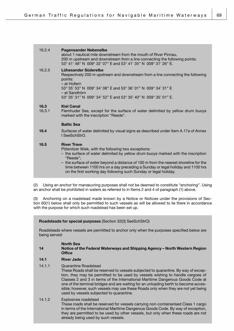
G e r m a n T r a f f i c R e g u l a t i o n s f o r N a v i g a b l e M a r i t i m e W a t e r w a y s 69
16.2.4 Pagensander Nebenelbe about 1 nautical mile downstream from the mouth of River Pinnau, 200 m upstream and downstream from a line connecting the following points: 53° 41’ 48’’ N 009° 32’ 07’’ E and 53° 41’ 35’’ N 009° 31’ 26’’ E.
16.2.5 Lühesander Süderelbe Respectively 200 m upstream and downstream from a line connecting the following
points: – at Hollern 53° 35’ 53’’ N 009° 34’ 08’’ E and 53° 36’ 01’’ N 009° 34’ 31’’ E – at Sandhörn 53° 35’ 31’’ N 009° 34’ 52’’ E and 53° 35’ 40’’ N 009° 35’ 01’’ E.
16.3 Kiel Canal16.3.1 Flemhuder See, except for the surface of water delimited by yellow drum buoys
marked with the inscription “Reede”.
Baltic Sea
16.4 Surfaces of water delimited by visual signs as described under Item A.17a of Annex I SeeSchStrO.
16.5 River Trave Pötenitzer Wiek, with the following two exceptions: – the surface of water delimited by yellow drum buoys marked with the inscription
“Reede”; – the surface of water beyond a distance of 100 m from the nearest shoreline for the
time between 1100 hrs on a day preceding a Sunday or legal holiday and 1100 hrs on the first working day following such Sunday or legal holiday.
(2) Using an anchor for manœuvring purposes shall not be deemed to constitute “anchoring”. Using an anchor shall be prohibited in waters as referred to in Items 2 and 4 of paragraph (1) above.
(3) Anchoring on a roadstead made known by a Notice or Notices under the provisions of Sec-tion 60(1) below shall only be permitted to such vessels as will be allowed to lie there in accordance with the purpose for which such roadstead has been set up.
Roadsteads for special purposes (Section 32(3) SeeSchStrO)
Roadsteads where vessels are permitted to anchor only when the purposes specified below are being served:
North Sea14 Notice of the Federal Waterways and Shipping Agency – North Western Region
Office
14.1 River Jade
14.1.1 Quarantine Roadstead These Roads shall be reserved to vessels subjected to quarantine. By way of excep-
tion, they may be permitted to be used by vessels wishing to handle cargoes of Classes 2 and 3 in terms of the International Maritime Dangerous Goods Code at one of the terminal bridges and are waiting for an unloading berth to become acces-sible; however, such vessels may use these Roads only when they are not yet being used by vessels subjected to quarantine.
14.1.2 Explosives roadstead These roads shall be reserved for vessels carrying non-containerised Class 1 cargo
in terms of the International Maritime Dangerous Goods Code. By way of exception, they are permitted to be used by other vessels, but only when these roads are not already being used by such vessels.

70 G e r m a n T r a f f i c R e g u l a t i o n s f o r N a v i g a b l e M a r i t i m e W a t e r w a y s
17 Notice of the Federal Waterways and Shipping Agency – Northern Region Office
North Sea
17.1 Road in the Heverstrom Fairway
This Road shall only be used by vessels intending to enter the Husumer Au.
17.2 River Elbe
17.2.1 Elbe Approach Road
This Road shall be permitted to be used only by vessels who are scheduled to enter into the river Elbe.
17.2.2 Medem Road
Only vessels with a length not exceeding 140.00 m shall be permitted to anchor on this Road. The specific anchoring site of each vessel shall be chosen so as to ensu-re that she will not drift off into the fairway even when swinging at anchor.
17.2.3 Neufeld-Reede Ost Road
See the entry “Restrictions“ reproduced under Item 20.1.1.6 below.
17.2.4 Brunsbüttel Nordwestreede Road
This Road shall be permitted to be used only by vessels who are scheduled to be admitted into the next free locks that are suitable for them. However, this shall not apply to pleasure craft wishing to enter or leave the Brunsbüttel Altenhafen Port. When the tidal current is coming in, vessels with a length overall exceeding 160.00 m may use the access to the Kiel Canal if this is necessary for them to enter the Road. Any such vessel shall send an application for exemption via VHF channel 13 – known by the name of Kiel Canal I – to the Lock-keeper 20 minutes prior to pas-sing Light-buoy 57, respectively, Light-buoy 60/NOK 1/Reede.
17.2.5 Brunsbüttel Südreede Road
Only vessels with a length not exceeding 120.00 m shall be permitted to anchor on this Road. The specific anchoring site of each vessel shall be chosen so as to ensu-re that she will not drift off into the fairway even when swinging at anchor.
17.2.6 Brunsbüttel Nordostreede Road
This Road shall only be used for the length of one tidal cycle. Safe berthing and unberthing in the area of the jetty off Brunsbüttel shall not be affected by the use of this Road; if necessary, vessels shall shift berth.
Vessels with a length exceeding 160.00 m approaching the Brunsbüttel Elbehafen Port from the open sea may take the shortest way to the access to the Kiel Canal. Any such vessel shall send an application for exemption via VHF channel 13 – known by the name of Kiel Canal I – to the Lock-keeper 20 minutes prior to passing Light-buoy 57.
17.2.7 Krautsand-Reede Road
See the entry “Restrictions” reproduced under Item 20.1.1.8 below.
17.2.8 Grauerort-Reede Road
See the entry “Restrictions” reproduced under Item 20.1.1.9 below.
17.2.9 Twielenfleth-Reede Road
See the entry “Restrictions” reproduced under Item 20.1.1.10 below.
17.2.10 List of Elbe roadsteads and facilities provided (waiting, bunkering, cargo tranship-ment)

G e r m a n T r a f f i c R e g u l a t i o n s f o r N a v i g a b l e M a r i t i m e W a t e r w a y s 71
List of Elbe roadsteads and facilities provided(waiting, bunkering, cargo transhipment)
Roadsteads as charted
Requirements acc. to Arts. 32, para. 3, 34, 35 and 36 SeeSchStrO (German Traffic Regulations for Navigable Maritime Waterways) E
lbe-
App
roac
h-R
eede
Auß
enel
be -
Ree
de
Neu
wer
k -
Ree
de
Med
em -
Ree
de
Neu
feld
- R
eede
Wes
t
Neu
feld
- R
eede
Ost
Nor
dwes
tree
de B
runs
bütt
el
Süd
reed
e vo
n B
runs
bütt
el
Nor
dost
reed
e B
runs
bütt
el
Frei
burg
- R
eede
Wis
chha
fen
- R
eede
Kra
utsa
nd -
Ree
de
Gra
uero
rt -
Ree
de
Twie
lenf
leth
- R
eede
Vessels not carrying certain dangerouscargoes
Waiting + + + + + + + + + + + + +
Bunkering + + + + + +
Transhipm. + + + + +
Vessels carrying explosive cargo
German IMDG CodeClasses 1, 4.1, and 5.2
Waiting + + + + + + +
Bunkering + + + +*
Transhipm. +*
Vessels, loadedINF-Code§ 30, para 1, No. 1aSeeSchStrO
Waiting + + +*** +***
Bunkering +
Transhipm.
Gas tankers, loaded
IGC CodeSection 30, para. 1, No. 1aSeeSchStrO
Waiting + + + + + + + + +
Bunkering + +* + + +** +**
Transhipm.
Gas tankers, empty
Classified as: not carrying certain dangerous cargoes
Waiting + + + + + + + + + + + + +
Bunkering + +* + + +** +**
Transhipm.
Chemical tankers, loaded
IBC Code, entry "15.19"Section 30, para. 1, No. 1bSeeSchStrO
Waiting + + + + + + + + + +
Bunkering + +* + + +** +**
Transhipm.
Chemical tankers, empty
not cleaned, degassed or completely inerted + flash point <35 °CSection 30, para. 1, No. 3,SeeSchStrO
Waiting + + + + + + + + + +
Bunkering + +* + + +** +**
Transhipm.
Chemical tankers, empty
cleaned, degassed or completely inerted or flash point >35 °CSection 30, para. 1, No. 3,SeeSchStrO
Waiting + + + + + + + + + + + + + +
Bunkering + +* + + +** +
Transhipm.
Oil tanker, loaded
Annex I MARPOLSection 30, para. 1, No. 1c,SeeSchStrO
Waiting + + + + + + + + +
Bunkering + +* + +
Transhipm.
Oil tanker, empty
not cleaned, degassed, or completelyinerted + flash point <35 °CSection 30, para. 1, No. 3,SeeSchStrO
Waiting + + + + + + + + +
Bunkering + +* + +
Transhipm.
Oil tanker, empty
cleaned, degassed, or completelyinerted + flash point >35 °CSection 30, para. 1, No. 3,SeeSchStrO
Waiting + + + + + + + + + + + + +
Bunkering + +* + + +
Transhipm.
Notes:Vessels not considerd to carry certain dagerous goods are- empty gas tankers- empty chemical and oil tankers, whose
last cargo had a flash point of >35 °C- empty chemical and oil tankers which
have been cleaned and gedassed or completely inerted
Master’s statement that the vessel is gas free is sufficient In
com
bina
tion
with
No.
17.
2.1
In c
ombi
natio
n w
ith N
o. 1
7.2.
2
In c
ombi
natio
n w
ith N
o. 2
0.1.
1.6
In c
ombi
natio
n w
ith N
o. 1
7.2.
4
In c
ombi
natio
n w
ith N
o. 1
7.2.
5
In c
ombi
natio
n w
ith N
o. 1
7.2.
6
In c
ombi
natio
n w
ith N
o. 2
0.1.
1.7
In c
ombi
natio
n w
ith N
o. 2
0.1.
2.5
and
No.
21.
3.1.
1
In c
ombi
natio
n w
ith N
o. 1
9.1.
1.6
and
No.
20.
1.1.
8
In c
ombi
natio
n w
ith N
o. 1
9.1.
3.1
and
No.
20.
1.1.
9
In c
ombi
natio
n w
ith N
o. 1
9.1.
3.2
and
No.
20.
1.1.
10
** = Transhipment prohibited during ship bunkering operations (No. 19.1.2.4 and 19.1.4.2)** = Bunkering prohibited in heavy sea states, ice drift (No. 19.1.3.1)*** = in coordination with the Brunsbüttel Vessel Traffic Service Centre

72 G e r m a n T r a f f i c R e g u l a t i o n s f o r N a v i g a b l e M a r i t i m e W a t e r w a y s
Baltic Sea
17.3 Kieler Förde
17.3.1 Holtenau-Reede Road This Road are permitted to be used only by vessels who are waiting for admission
into the next free locks, or for a berth in the Port of Kiel to become accessible, or for the weather to improve. However, this regulation shall not apply to vessels wishing to enter, respectively leave, the ports, berthing and mooring sites at Kiel-Holtenau and Kiel-Friedrichsort nor to pleasure craft.
(4) A continuous anchor watch shall be kept aboard any vessel or extraordinary floating object lying at anchor near a fairway or on a roadstead as well as aboard any vessel for which an anchoring ban under the provisions of paragraph (3) above is not effective. However, this provision shall not apply to vessels of less than 12 metres in length when in waters as referred to in Section 10(4) above.
Section 33 Berthing and mooring
(1) No vessel shall impede any other vessel through her anchoring or mooring. Once a vessel has begun with a berthing manœuvre, all other vessels shall take this fact into account and shall navigate with the appropriate care and diligence.
(2) Berthing and mooring shall be prohibited
1. at flood barriers, riverside buildings, guiding racks, level-gauging posts, floating and fixed aids to navigation;
2. at banks or embankments where the soil is liable to break away into the water;3. at locations where anchoring is prohibited under the provisions of Section 32(1)(Item 1 or 5) abo-
ve;4. along stretches of waterways where anchoring is prohibited under the provisions of Section 32(1)
(Item 6) above;5. at such locations as have been made known by a Notice or Notices under the provisions of Sec-
tion 60(1) below.
Prohibition to berth and moor (Section 33(2)(Item 5) SeeSchStrO)Locations where berthing and mooring are prohibited:
North Sea
18 Notice of the Federal Waterways and Shipping Agency – Northern Region Office
18.1 Locks forming part of the Eider Barrier (Eidersperrwerk)
18.1.1 Seaward by-port
18.1.1.1 Separation jetty, except for vessels waiting for admission into the locks
18.1.1.2 Nordkaje Quay, except for fishing vessels (for the time of unloading their catch) and for passenger ships (for the time of passenger embarkation and disembarkation)
18.1.2 Landward by-port
18.1.2.1 Separation jetty, except for vessels in the Public Service and vessels owned and ope-rated by the Deutsche Gesellschaft zur Rettung Schiffbrüchiger (German National Lifeboat Association)
18.1.2.2 Nordkaje Quay, except for vessels waiting for admission into the locks and for ves-sels issued with a special permit from the Tönning Waterways and Shipping Office

G e r m a n T r a f f i c R e g u l a t i o n s f o r N a v i g a b l e M a r i t i m e W a t e r w a y s 73
18.2 River Elbe and tributaries
18.2.1 On the waiting dolphins of the following barriers and bridges; With the following exceptions: when the barrier or bridge is closed or when the visu-
al sign described as the first sign under Item A.19(a) of Annex I SeeSchStrO.
18.2.1.1 Wischhafener Süderelbe
18.2.1.2 Bützflether Süderelbe
18.2.1.3 River Oste Estuary
18.2.1.4 Freiburger Hafenpriel
18.2.1.5 River Schwinge
18.2.1.6 River Lühe
18.2.1.7 River Este
18.2.1.7.1 Äußeres Sperrwerk Barrier
18.2.1.7.2 Inneres Sperrwerk Barrier
18.2.1.7.3 Road Bridge near Hove
18.2.1.7.4 Road Bridge near Estebrügge
18.2.1.8 River Stör
18.2.1.9 River Krückau
18.2.1.10 River Pinnau
18.3 Kiel Canal
18.3.1 Brunsbüttel Alter Vorhafen by-port, except for pilot transfer craft and tugs issued with a permit
from the Brunsbüttel Waterways and Shipping Office
18.3.2 Kiel-Holtenau The dolphins in the Alter Vorhafen by-port
18.3.3 Kiel Canal and Gieselaukanal The entire embankment as well as all installations intended for use by vessels owned
and operated by the Federal Waterways and Shipping Administration. No vessel shall be launched over such installations, either.
(3) Whenever possible, each vessel moored alongside another vessel shall be adequately tied up by both ends to the bank or embankment.
(4) No vessel, when moored, shall turn her propeller except
1. for trial purposes, but then only with the least power possible applied,2. immediately before setting off and,3. in either case, when other vessels or installations will not be put at any risk.
Section 34 Cargo-handling operations
At locations other than ports, harbours, and cargo-handling terminals, cargo-handling operations (bun-kering included) shall be permitted only on such roadsteads and mooring sites as have been made known by a Notice or Notices under the provisions of Section 60(1) below; any preconditions specified for that purpose shall be complied with.

74 G e r m a n T r a f f i c R e g u l a t i o n s f o r N a v i g a b l e M a r i t i m e W a t e r w a y s
Roadsteads and mooring sites for cargo-handling and bunkering (Section 34 SeeSch StrO)
Roadsteads and mooring sites where cargo-handling and bunkering are permitted under the restrictions listed hereunder:
North Sea
15 Notice of the Federal Waterways and Shipping Agency – North Western Region Office
15.1 River Weser Prior to bunkering outside the ports, a permit to do so shall be obtained from the
Waterways and Shipping Office at Bremen respectively at Bremerhaven via Bremen Weser Traffic.
15.2 River Lesum Bunkering station for pleasure craft at kilometric marking 8.79 (North Shore).
15.3 River Jade Prior to bunkering outside the ports, a permit to do so shall be obtained from the
Waterways and Shipping Office in Wilhelmshaven through the Vessel Traffic Service Centre.
19 Notice of the Federal Waterways and Shipping Agency – Northern Region Office
19.1 River Elbe
19.1.1 Roadsteads where cargo-handling and bunkering are permitted.
19.1.1.1 Außenelbe-Reede Road
19.1.1.2 Neuwerk-Reede Road
19.1.1.3 Medem-Reede Road
19.1.1.4 Neufeld-Reede West Road
19.1.1.5 Twielenfleth-Reede Road
19.1.2 Roadsteads where vessels carrying goods of Class 1 in terms of the International Maritime Dangerous Goods Code are permitted to take bunkers:
19.1.2.1 Außenelbe-Reede Road
19.1.2.2 Medem-Reede Road
19.1.2.3 Neufeld-Reede West Road
19.1.2.4 Wischhafen-Reede Road: Restrictions: No cargo-handling operations permitted while vessel is bunkering.
19.1.3 Roadsteads where tankers in terms of Section 30(1)(Items 1a and b) and of Section 30(1)(Item 2) SeeSchStrO are permitted to take bunkers:
19.1.3.1 Grauerort-Reede Road: Restrictions: Only gas and chemical tankers intending to use the jetty off Bützfleth may take bun-
kers here. Any bunkering operations shall be applied for in good time with the Brunsbüttel Vessel Traffic Centre. This is also the organization where to report the start and termination of bunkering operations (via telephone: + 49 48 52 88 53 93 or 84 00 or via VHF channel 68 – Brunsbüttel Elbe Traffic). No repairs to be carried out while bunkering is in progress. Bunkering shall be prohibited in a heavy seas and drifting ice.

G e r m a n T r a f f i c R e g u l a t i o n s f o r N a v i g a b l e M a r i t i m e W a t e r w a y s 75
19.1.3.2 Twielenfleth road
Prerequisite: Only gas and chemical tankers intending to use the jetty off Büthfleth may take
bunkers here. Any bunkering operations shall be applied for in good time at the Brunsbüttel Vessel Traffic Centre. This office must also be informed of the start and termination of bunkering operations (by telephone: +49 48 52 88 53 93 or 84 00 or via VHF channel 68 – Brunsbüttel Elbe Traffic coastal radio station). No repairs shall be carried out while bunkering is in progress. Bunkering is prohibited in a heavy seas and drifting ice.
19.1.4 Roadsteads where tankers in terms of Section 30(1)(Items 1 and 2) SeeSchStrO are permitted to take bunkers:
19.1.4.1 Außenelbe-Reede Road
19.1.4.2 Neuwerk-Reede Road
19.1.4.3 Medem-Reede Road
19.1.4.4 Neufeld-Reede Road
19.2 Kiel Canal
19.2.1 Bunkering sites:
19.2.1.1 Bunkering bridge of the Elf Bitumenwerk company in Brunsbüttel Delimitation: To the South, by the shoreline; to the West and the East, by lines running vertically from the shore towards the
Canal centreline at kilometric markings 4.45 and 5.16, respectively; to the North, by a line running parallel to the shoreline at a distance of 60 m from the
shore.
19.2.1.2 Bunkering bridge of the Nord- und Westdeutsche Bunker GmbH (NWB) company in Brunsbüttel
Delimitation: To the North, by the shoreline; to the West and the East, by lines running vertically from the shore towards the
Canal centreline at kilometric markings 2.32 and 2.41, respectively; to the South, by a line running parallel to the shoreline at a distance of 60 m from the
shore.
19.2.1.3 Lürssen-Shipyard at the Audorfer See-Water
19.2.1.4 Projensdorf Bunkering Bridge Delimitation: To the South, by the shoreline; to the West and the East, by lines running vertically from the shore towards the
Canal centreline at kilometric markings 94.35 and 94.67, respectively; to the North, by a line running parallel to the shoreline at a distance of 60 m from the
shore.
19.2.1.5 Bunkering station of the Bominflot Kiel Tanlager at Kiel-Holtenau Delimitation: To the South, by the wall of the quay; to the West and the East, by lines running vertically from the shore towards the
Canal centreline at kilometric markings 96.80 and 97.23, respectively; to the North, by a line running parallel to the shoreline at a distance of 35 m from the
shore.
19.2.1.6 Außenhafen Port at Kiel-Holtenau Delimitation: To the North, by the pierhead running all along the quayside road; to the West and
the East, by lines running vertically from the pierhead line; to the South, by a line running parallel to the pierhead line at a distance of 30 m from
the pierhead.
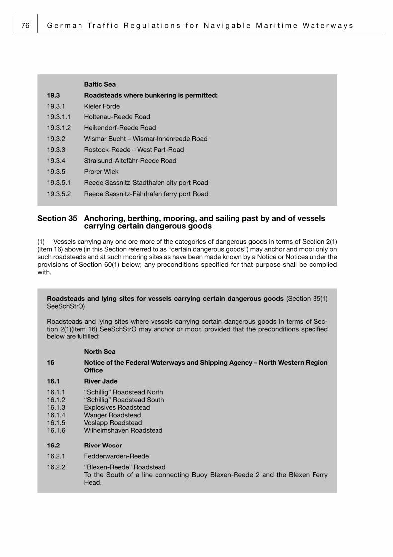
76 G e r m a n T r a f f i c R e g u l a t i o n s f o r N a v i g a b l e M a r i t i m e W a t e r w a y s
Baltic Sea
19.3 Roadsteads where bunkering is permitted:
19.3.1 Kieler Förde
19.3.1.1 Holtenau-Reede Road
19.3.1.2 Heikendorf-Reede Road
19.3.2 Wismar Bucht – Wismar-Innenreede Road
19.3.3 Rostock-Reede – West Part-Road
19.3.4 Stralsund-Altefähr-Reede Road
19.3.5 Prorer Wiek
19.3.5.1 Reede Sassnitz-Stadthafen city port Road
19.3.5.2 Reede Sassnitz-Fährhafen ferry port Road
Section 35 Anchoring, berthing, mooring, and sailing past by and of vessels carrying certain dangerous goods
(1) Vessels carrying any one ore more of the categories of dangerous goods in terms of Section 2(1)(Item 16) above (in this Section referred to as “certain dangerous goods”) may anchor and moor only on such roadsteads and at such mooring sites as have been made known by a Notice or Notices under the provisions of Section 60(1) below; any preconditions specified for that purpose shall be complied with.
Roadsteads and lying sites for vessels carrying certain dangerous goods (Section 35(1) SeeSchStrO)
Roadsteads and lying sites where vessels carrying certain dangerous goods in terms of Sec-tion 2(1)(Item 16) SeeSchStrO may anchor or moor, provided that the preconditions specified below are fulfilled:
North Sea
16 Notice of the Federal Waterways and Shipping Agency – North Western Region Office
16.1 River Jade
16.1.1 “Schillig” Roadstead North16.1.2 “Schillig” Roadstead South16.1.3 Explosives Roadstead16.1.4 Wanger Roadstead16.1.5 Voslapp Roadstead16.1.6 Wilhelmshaven Roadstead 16.2 River Weser
16.2.1 Fedderwarden-Reede
16.2.2 “Blexen-Reede” Roadstead To the South of a line connecting Buoy Blexen-Reede 2 and the Blexen Ferry
Head.

G e r m a n T r a f f i c R e g u l a t i o n s f o r N a v i g a b l e M a r i t i m e W a t e r w a y s 77
20 Notice of the Federal Waterways and Shipping Agency – Northern Region Office
20.1 River Elbe
20.1.1 Roadsteads for tankers in terms of Section 30 (1)(Item 1 and 3) SeeSchStrO
20.1.1.1 Elbe Approach Road
20.1.1.2 Außenelbe-Reede Road
20.1.1.3 Neuwerk-Reede Road
20.1.1.4 Medem-Reede Road
20.1.1.5 Neufeld-Reede West Road
20.1.1.6 Neufeld-Reede Ost Road Requirement: Use of the roadstead is restricted to vessels waiting to enter Kiel Canal. If there are
no vessels waiting, vessels bound for Kiel Canal are allowed to navigate in the area.
20.1.1.7 Freiburg-Reede Road Except for tankers carrying or having carried gaseous goods in terms of Section
30(1)(Item 1a) SeeSchStrO
20.1.1.8 Krautsand road outside of the fairway Except for tankers in terms of Section 30 (1)(Items 1a and 1b) of the German Traffic
Regulations for Navigable Maritime Waterways
20.1.1.9 Grauerort-Reede Road Except for tankers in terms of Section 30(1)(Item 1c) and of Section 30(1)(Item 3)
SeeSchStrO Restrictions: Only gas and chemical tankers unable to proceed to their intended berth because of
the jetty off Bützfleth being occupied may anchor on this Road. No more than two vessels may anchor there at any one time. This Road shall be left immediately when the terminal off Bützfleth that is intended for the anchoring vessel has become vacant but, at any rate, upon the lapse of 24 hours.
20.1.1.10 Twielenfleth-Reede Road Except for tankers in terms of Section 30(1)(Item 1c) and of Section 30(1)(Item 3)
SeeSchStrO Restrictions: Only gas and chemical tankers unable to proceed to their intended berth because of
the jetty off Bützfleth being occupied and Grauerort-Reede Road already being occupied by two vessels may anchor on this Road. This Road shall be left immedi-ately when the terminal off Bützfleth that is intended for the anchoring vessel has become vacant but, at any rate, upon the lapse of 24 hours.
20.1.2 Roadsteads for vessels carrying cargoes of Class 1, 4.1 and 5.2 in terms of the IMDG Code German
20.1.2.1 Elbe Approach Road
20.1.2.2 Außenelbe-Reede Road
20.1.2.3 Medem-Reede Road
20.1.2.4 Neufeld-Reede West Road
20.1.2.5 Wischhafen-Reede Road Restrictions: On this Road, a maximum of the quantities mentioned may be present of goods of
the divisions listed hereunder:

78 G e r m a n T r a f f i c R e g u l a t i o n s f o r N a v i g a b l e M a r i t i m e W a t e r w a y s
Division 1.1 500 000 kg Division 1.2 10 000 000 kg Division 1.3 10 000 000 kg Division 1.4 unlimited quantities Division 1.5 500 000 kg When goods of different divisions of Class 1 are present on these Roads, all explo-
sive substances and articles shall be assigned to the division with the lowest divisi-on. When goods of Division 1.5 are present on these Roads together with goods of other divisions of Class 1, all goods present on these Roads shall be assigned to Division 1.1.
20.1.3 Lying sites for vessels carrying more than 100 kg of goods of Class 1 in terms of the International Maritime Dangerous Goods Code:
20.1.3.1 Ruthenstrom (kilometric marking 4.2, left bank) Restrictions: Only one vessel shall be permitted to be lying there. Once laden, a vessel shall not
keep lying at the site for more than 24 hours.
20.1.3.2 The North-East mouth of the Dwarsloch in a 20-metre diameter around the mooring site established there.
20.1.4 Lying sites for tankers in terms of Section 30(1)(Items 1 and 2) SeeSchStrO:
20.1.4.1 Brunsbüttel Elbehafen Port, West part Tankers in terms of Section 30(1)(Items 1a and 1c) SeeSchStrO
20.1.4.2 Jetty off Bützfleth, South part Tankers in terms of Section 30(1)(Items 1a and 1b) SeeSchStrO Restrictions: (a) A tanker carrying inflammable liquids within the scope of the substances listed in
Section 30(1)(Item 1b) SeeSchStrO shall be permitted to be lying at the outside edge of the Elbanleger terminal (upstream from the access bridge), provided that no gas tanker is lying at the inside edge of the Elbanleger terminal. How-ever, this latter restriction shall not apply when the tanker lying at the outside edge of the Elbanleger terminal has been fully inerted.
(b) No laden tanker other than one carrying sodium hydroxide solution shall be per-mitted to be lying at the outside edge of the Elbanleger terminal (right downstream from the access bridge).
(c) Empty vessels having been cleaned and de-gassed or having been fully inerted and now lying at the shoreside terminal in the inner South harbour basin as well as vessels carrying goods other than inflammable liquids may discharge wastes and take bunkers making use of waterside arrangements.
20.1.5 Roads for ships with loads according to Section 30(1)(Item 2)
20.1.5.1 Elbe Approach Road
20.1.5.2 Außenelbereede Road
20.1.5.3 Neufeld Road East Only as a waiting road for the Kiel Canal
20.1.5.4 Nordwestreede Road Only as a waiting road for the Kiel Canal
20.2 River Schwinge
20.2.1 Lying sites for tankers in terms of Section 30(1)(Items 1 and 3) SeeSchStrO:
20.2.1.1 Stadersand, outward emergency lying site at the river Schwinge Weir (kilometric marking 3.80 to kilometric marking 3.38)
20.2.1.2 Port of Stade, West Jetty

G e r m a n T r a f f i c R e g u l a t i o n s f o r N a v i g a b l e M a r i t i m e W a t e r w a y s 79
20.3 River Stör
20.3.1 Lying site for tankers in terms of Section 30(1)(Items 1 and 3) SeeSchStrO:
20.3.1.1 Port of Itzehoe-Sude, lying site at kilometric marking 24.8, right bank
20.4 Kiel Canal
20.4.1 Lying sites – accepting also tankers in terms of Section 30(1) (Item 2) SeeSchStrO:
20.4.1.1 Bunkering bridge of the Total Bitumen company in Brunsbüttel Delimitation: as given under Item 19.2.1.1 (Notice of WSD Nord below section 34
SeeSchStrO)
20.4.1.2 Bunkering bridge of the Nord- und Westdeutsche Bunker GmbH (NWB) company in Brunsbüttel
Delimitation: as given under Item 19.2.1.2 (Notice of WSD Nord below section 34 SeeSchStrO)
20.4.1.3 Bunkering station of the Bominflot Kiel Tanklager company at Kiel-Holtenau Delimitation: as given under Item 19.2.1.6 (Notice of WSD Nord below section 34
SeeSchStrO)
20.4.1.4 All sidings, except for those parts thereof that are needed for the passage of transit-ing vessels
20.4.1.5 DEA/SASOL bridges 1, 2, and 3
20.4.1.6 Eastern part (200 m) of the railway station’s dolphins
20.4.1.7 Navy dolphins, northern part.
20.4.1.8 Bunkering station Bayer-Brücke-NOK
20.4.2 Restrictions applying to lying at the sites listed under Items 20.4.1.1 to 20.4.1.8:
20.4.2.1 Vessels shall only be allowed to use the mooring sites under 20.4.1.1 to 20.4.1.3 above for the purpose and during the time of bunkering and/or discharging oily bal-last, slops, and bilge water.
This provision does not apply to the mooring sites referred to under 20.4.1.5 (at bridge 1, only fatty alcohols are allowed to be handled subject to the conditions in the river and shipping police permit), and to the mooring sites under 20.4.1.6 and 20.4.1.7 above, where only waiting is allowed.
20.4.2.2 No vessel shall be permitted to be lying in a siding for any reason other than on account of the prevailing traffic or weather conditions.
20.4.3 A minimum distance of 50 m shall be kept from any other moored vessel; however, this regulation shall not apply to the sidings.
20.4.4 All cargo tanks shall be closed on tankers carrying goods in terms of Section 30(1)(Item 1) SeeSchStrO or who have not been de-gassed so as to be gas-free after having carried such goods.
20.4.5 Tanks shall not be permitted to be cleaned or de-gassed.
20.4.6 Cargo tanks shall not be permitted to receive any ballast, with the exception of the cargo tanks in tankers having discharged cargoes with a flashpoint exceeding 55 °C. Arrangements shall be made to ensure that any air-vapour mixture that may be expelled from the tanks during ballasting operations will not be inflammable or toxic any more.

80 G e r m a n T r a f f i c R e g u l a t i o n s f o r N a v i g a b l e M a r i t i m e W a t e r w a y s
20.5 Baltic Sea
Roadsteads for tankers in terms of Section 30(1)(Item 1 and 2) SeeSchStrO
20.5.1 Kieler Förde
20.5.1.1 Holtenau-Reede Road
20.5.1.2 Heikendorf-Reede Road
20.5.2 Wismar Bucht – Wismar-Innenreede Road
20.5.3 Rostock-Reede – West Part – Road
20.5.4 Stralsund-Altefähr-Reede Road
20.5.5 Prorer Wiek
20.5.5.1 Reede Sassnitz-Stadthafen (city port) Road
20.5.5.2 Reede Sassnitz-Fährhafen (ferry port) Road
(2) When more than one vessel carrying certain dangerous goods are lying simultaneously on one roadstead or at one mooring site, they shall keep a safe distance from one another, due account being taken of the circumstances prevailing on site.
(3) All vessels other than tugs, supply and tank-cleaning vessels and such vessels as may be invol-ved in current cargo-handling operations shall keep a safe distance (particular account being taken of sparking hazards) from vessels carrying certain dangerous goods. However, even the vessels just refer-red to shall not enter the waters where such roadstead or mooring site is located, unless their funnels and exhaust pipes have been fitted with devices or arrangements to prevent sparking.
(4) In the case of a moored tanker that has not been cleaned and de-gassed after discharging certain dangerous goods, no vessel whatsoever shall be lying alongside while the tanker’s tanks are being filled with ballast water, whereas only the necessary tank-cleaning vessels shall be permitted to be lying alongside as long as tank-cleaning or de-gassing operations are in process.
(5) A moored vessel, when carrying certain dangerous goods, and a vessel lying near such vessel shall be capable of shifting berths at all times and without delay.
Section 36 Handling of certain dangerous goods
(1) Certain dangerous goods in terms of Section 2(1)(Item 16) above shall be handled only on such roadsteads and mooring sites as have been made known by a Notice or Notices under the provisions of Section 60(1) below; any preconditions specified for that purpose shall be complied with. The inten-tion of handling such goods shall be notified to the competent shipping police authority in good time.
Roadsteads and lying sites for the handling of certain dangerous goods(Section 36(1) SeeSch StrO)
Roadsteads and lying sites where vessels carrying certain dangerous goods in terms of Section 2(1)(Item 16) SeeSchStrO may handle such cargoes, provided that the preconditions specified below are fulfilled:
North Sea
17 Notice of the Federal Waterways and Shipping Agency – North Western Region Office
[This Section has been suspended.]

G e r m a n T r a f f i c R e g u l a t i o n s f o r N a v i g a b l e M a r i t i m e W a t e r w a y s 81
21 Notice of the Federal Waterways and Shipping Agency – Northern Region Office
21.1 Helgoland Protection and Safety Haven of Helgoland, Südhafen-Westkaje Jetty Tankers in terms of Section 30(1)(Item 1c) SeeSchStrO Restrictions for cargo handling: Cargo-handling operations shall be permitted only for the time between 2300 hrs
and 0700 hrs. For the time between 1 May and 1 September of each year, cargo-handling operations and even the mere lying of tankers shall not be permitted bet-ween 2400 hrs on any Friday and 2400 hrs on any Sunday. For the time between 2400 hrs on the Wednesday preceding Pentecost and 2400 hrs on the Wednesday following Pentecost of each year, cargo-handling operations and even the mere lying of tankers shall not be permitted.
21.2 Protection and Safety Haven of Hörnum, Westkaje Jetty Tankers in terms of Section 30(1)(Item 1c) SeeSchStrO
21.3 River Elbe
21.3.1 Roadsteads for vessels carrying goods of Class 1 in terms of the IMDG Code:
21.3.1.1 Wischhafen-Reede Road The same restrictions for cargo-handling apply as specified under Item 20.1.2.3. No discharge of wastes shall be permitted during cargo-handling operations.
21.3.2 Cargo-handling places for tankers in terms of Section (1)(Items 1 and 3) SeeSch-StrO
21.3.2.1 Brunsbüttel Elbehafen Port, West part Tankers in terms of Section 30(1)(Items 1a and 1c) SeeSchStrO
21.3.2.2 Jetty off Bützfleth, South Part Tankers in terms of Section 30(1)(Items 1a and 1b) SeeSchStrO
21.3.2.2.1 Restrictions for cargo handling: (a) When inflammable liquids within the scope of the substances listed in Sec-
tion 30(1)(Item 1b) SeeSchStrO are being handled at the outside edge of the Elbanleger terminal (upstream from the access bridge) no gas tanker shall be permitted to be lying at the inside edge of the Elbanleger terminal. However, this restriction shall not apply when the tanker lying at the outside edge of the Elban-leger terminal is operating under the closed system and has been fully inerted. When cargo-handling operations are in progress at the outside and/or the inside edge of the Elbanleger terminal, no vessels shall be permitted to be lying along-side any of the vessels moored there.
(b) No cargo other than sodium hydroxide solution shall be permitted to be handled at the outside edge of the Elbanleger terminal (right downstream from the access bridge).

82 G e r m a n T r a f f i c R e g u l a t i o n s f o r N a v i g a b l e M a r i t i m e W a t e r w a y s
(c) No cargoes other than inflammable liquids within the scope of the substances listed in Section 30(1)(Item 1b) SeeSchStrO shall be permitted to be handled at the shoreside terminal in the inner South harbour basin. As long as cargoes other than inflammable liquids are being handled, empty vessels having been cleaned and de-gassed or having been fully inerted as well as vessels carrying goods other than inflammable liquids may discharge wastes and take bunkers making use of waterside arrangements. Arrangements shall be made to ensure that any air-vapour mixture that may be expelled from the tanks during loading, ballas-ting, and de-gassing operations will not be toxic any more when reaching the area outside the designated cargo-handling terminal.
21.3.2.2.2 At the inside edge of the Elbanleger terminal, cargo-handling shall be permitted to take place only under the closed system. When cargo-handling operations are in progress, no vessel shall be permitted to be lying alongside the vessel moored there.
21.4 River Schwinge
21.4.1 Port of Stade, West-Jetty Tankers in terms of Section 30(1)(Items 1c and 3) SeeSchStrO
21.5 River Stör
21.5.1 Port of Itzehoe-Sude, lying-site at kilometric marking 24.8, right bank Tankers in terms of Section 30(1)(Items 1c and 3) SeeSchStrO
21.6 Kiel Canal
21.6.1 DEA-Cargo-handling place (Bridge IV) in the turning basin at the oilport of Bruns-büttel
Tankers in terms of Section 30(1)(Item 1c) SeeSchStrO carrying goods with a flash-point of 55 °C and above.
(2) Throughout cargo-handling operations, only one vessel involved in such operations may be lying alongside on either side of a vessel carrying certain dangerous goods.
(3) Vessels other than those involved in cargo-handling operations shall keep a safe distance from the vessels therein involved and carrying certain dangerous goods; otherwise, they shall move away from the roadstead or mooring site.
(4) Upon completion of cargo-handling operations, the vessel shall, without delay, leave the roads-tead or mooring site.
(5) All other regulations concerning the handling and carriage of dangerous goods shall remain unaf-fected by the foregoing provisions.

G e r m a n T r a f f i c R e g u l a t i o n s f o r N a v i g a b l e M a r i t i m e W a t e r w a y s 83
Part Six
Miscellaneous provisions
Section 37 Conduct in the event of a marine casualty and of the loss overboard of objects
(1) Where there is a risk of a vessel sinking, such vessel shall be taken out of the fairway so far that the safe passage of other vessels will not be impeded. In the event of a collision having occurred, the person in command of any one of the vessels involved shall also be under the obligation to take such vessel out of the fairway, provided that the vessel is still in a floating condition.
(2) Where the navigable condition of a waterway or the safety and easy flow of traffic is affected or where such danger is imminent
1. as a result of a vessel, floating plant or installation, or extraordinary floating object helplessly drif-ting, stuck fast, grounded, or sunk, or as a result of any other object adrift or aground, or
2. as a result of a marine casualty, a fire, or any other incident aboard a vessel, floating installation, or extraordinary floating object,
the competent waterways and shipping office or the VTS centre shall be informed without delay.
(3) The location where a vessel has sunk shall provisionally be marked, without delay, by the person who had been in command of such vessel. In the event of a collision resulting in the sinking of one or more vessels, each person in command of any one of the vessels involved shall be under the obligation to provisionally mark also the location where the other vessel (vessels) involved in the collision has (have) sunk, provided that his own vessel is still in a floating condition. Such person shall not continue his voyage until the competent waterways and shipping office has given permission to do so.
(4) A vessel stuck fast may make use of her engine or engines in an effort to break free, unless this cannot be done without inflicting damage upon the waterway – including the banks or embankments of, any structures, navigational aids and installations in, on, or near the waterway – or putting the safe-ty of navigation at risk.
(5) Aboard any vessel where the “Stay away!” signal described under Item 2.2 of Annex II.2 to the present Ordinance is heard, all measures necessary shall be taken to avoid the imminent hazard; in particular,
1. all openings other than those required to keep the vessel operating shall be closed;2. all auxiliary machinery other than that required to ensure the safety of the vessel herself, her crew,
or her cargo shall be shut off;3. open fires other than those well under guard shall be extinguished and, in particular, all smoking
shall be terminated;4. the operation of equipment comprising red-hot or sparking parts or components shall be discon-
tinued.
Section 38 Fishing and hunting
Certain modes of fishing, shooting and/or hunting shall be prohibited in such waters as have been made known by a Notice or Notices under the provisions of Section 60(1) below. An anchoring ban under the provisions of Section 32 above shall not apply to dedicated fishing vessels in a fairway, except when such fishing vessel is in waters made known under the provisions of the foregoing sen-tence.

84 G e r m a n T r a f f i c R e g u l a t i o n s f o r N a v i g a b l e M a r i t i m e W a t e r w a y s
Ban on fishing and hunting (Section 38 SeeSchStrO)
Waters where fishing, shooting and/or hunting are prohibited:
North Sea
18 Notice of the Federal Waterways and Shipping Agency – North Western Region Office
18.1 River Jade Waters within delimited or marked fairways, off lying, mooring, and bathing sites,
port entrances, in the vicinity of the dumping grounds for dredged spoils and of construction sites as made known from time to time, as well as designated roads-teads.
18.2 River Weser
18.2.1 Waters where fishing, shooting and/or hunting are prohibited include:
18.2.1.1 the fairway
18.2.1.2 the designated roadsteads
18.2.1.3 Waters outside the fairway as follows: (a) Limited to the north by the line connecting buoys Bu 27 and Bu14 with the lower
light Hofe and extending to the eastern shoreline; to the east by the shoreline at MLWS up to the Geeste north mole; to the south by the line connecting the Geeste north mole with buoy 63 and the western shoreline next to the Titan quay; to the west by the western shoreline next to Titan quay up to buoy 59; from there, by the line connecting the groyne buoys and buoy Bu 27;
(b) the stretch of water extending between kilometric marking 27.3 (pair of buoys 109/112) and kilometric marking 24.3 (pair of buoys 115/118) in the “Farger Kurve” Bend;
(c) the area of the “Notwendestelle Vegesack” Emergency Turning Site West of Buoy 121 (kilometric marking 20.8) and Buoy 123 (kilometric marking 20.0).
18.2.2 Waters where, by way of exception, fishing is permitted for vessels engaged in crab fishing underway include
18.2.2.1 the fairway of River Weser between, on the one side, a line connecting Buoys Bu 27 and Bu 14 and, further seawards,
(a) for fishing vessels not equipped with a VHF radiotelephone installation enabling communication with Bremerhaven Weser Traffic at ranges of visibility exceeding 1000 m under the proviso that they keep to the starboard side of the fairway (Section 22(1)(first sentence) SeeSchStrO) and that they refrain from fishing in areas in a 100-metre diameter around buoys;
(b) for fishing vessels keeping constant contact with Bremerhaven Weser Traffic via VHF radiotelephone and complying with any instructions received therefrom
– at ranges of visibility exceeding 1000 m under the proviso that they keep to the starboard side of the fairway (Section 22(1 first sentence) SeeSchStrO)
– at ranges of visibility exceeding 3000 m under the proviso that they may be proceeding on the port side of the fairway under the provisions of Sec - tion 22(1)(second sentence) SeeSchStrO – while observing the provisions of Section 24(3) SeeSchStrO – unless instructions to the contrary are being given by Bremerhaven Weser Traffic;

G e r m a n T r a f f i c R e g u l a t i o n s f o r N a v i g a b l e M a r i t i m e W a t e r w a y s 85
22 Notice of the Federal Waterways and Shipping Agency – Northern Region Office
22.1 West Coast of Schleswig-Holstein
22.1.1 The waters where fishing (with the exception of mussel harvesting) is prohibited are the mussel-hatching grounds marked by the visual sign described under Item B.16(c) of Annex I SeeSchStrO.
22.1.2 Areas at a distance of less than 200 m from port entrances, embarkation and disem-barkation points, lying and warning sites, water-level gauges, and measuring appli-ances.
22.1.3 Areas in a 300-m diameter around cable routes and under-water lines, including those marked by visual signs as described, respectively, under Items B.16(b) and B.16(e) of Annex I SeeSchStrO.
22.2 River Elbe and tributaries
22.2.1 Fairways
22.2.2 Roadsteads
22.2.3 Areas at a distance of less than 200 m from port entrances, embarkation and disem-barkation points, lying and warning sites, water-level gauges, and measuring appli-ances.
22.2.3.1 Cuxhaven outside of the fairway in the area south of the line of green buoys bet-ween buoys 31a/32a and 35/36.
22.2.4 Areas in a 300-m diameter around cable routes and under-water lines, including those marked by visual signs as described, respectively, under Items B.16(b) and B.16(e) of Annex I SeeSchStrO.
Exceptions:
22.2.5 River Elbe
22.2.5.1 Ban applying to vessels fishing while lying at anchor:
22.2.5.1.1 The area outside of the fairway to the East of a line connecting the following points, viz:
(a) 53° 53.1580’ N 008° 46.9240’ E, (b) 53° 52.7580’ N 008° 46.9240’ E, and (c) Buoy 38, outside the navigation channel and Neufeld-Reede roadstead up to a line running
360° from the Neufeld-Reede 12 buoy to the coastline of Schleswig-Holstein
22.2.5.1.2 The area inside a line connecting the following points, viz: (a) 53° 52.2580’ N 009° 02.1240’ E, (b) 53° 52.7746’ N 009° 03.8406’ E, (c) 53° 52.8080’ N 009° 04.8240’ E, (d) 53° 52.2580’ N 009° 02.1240’ E.
22.2.5.1.3 The area to the North of a line connecting the following points, viz: (a) 53° 53.2746’ N 009° 08.5740’ E, (b) 53° 53.2913’ N 009° 10.0073’ E.
22.2.5.1.4 The area to the North of a line connecting the following points, viz: (a) 53° 53.2580’ N 009° 11.5740’ E, (b) 53° 53.1080’ N 009° 13.2407’ E.
22.2.5.1.5 The area up to 100 m to the South of a line connecting the following points, viz: (a) 53° 53.0413’ N 009° 13.2406’ E, (b) 53° 52.7913’ N 009° 14.7573’ E.
22.2.5.1.6 The area to the North of a line connecting the following points, viz: (a) 53° 52.6413’ N 009° 16.0573’ E, (b) 53° 50.4580’ N 009° 21.1573’ E.

86 G e r m a n T r a f f i c R e g u l a t i o n s f o r N a v i g a b l e M a r i t i m e W a t e r w a y s
22.2.5.1.7 The area inside a line connecting the following points, viz: (a) 53° 48.7413’ N 009° 22.4240’ E, (b) 53° 48.7746’ N 009° 22.5073’ E, (c) 53° 47.4580’ N 009° 23.3407’ E, (d) 53° 47.4247’ N 009° 23.2407’ E.
22.2.5.1.8 The area up to 200 m to the East of a line connecting the following points, viz: (a) 53° 46.5580’ N 009° 23.0260’ E, (b) 53° 45.7080’ N 009° 23.5407’ E.
22.2.5.1.9 The area between the sector lines at 316.2° and 322.2° from the Steindeich Light up to the Pagensand-Nord Light
22.2.5.1.10 The area up to 50 m to the East of a line connecting the following points, viz: (a) 53° 41.2580’ N 009° 29.6907’ E, (b) 53° 39.8163’ N 009° 30.5490’ E.
22.2.5.1.11 The area to the East of a line connecting the following points, viz: (a) 53° 39.9747’ N 009° 30.8240’ E, (b) 53° 38.1413’ N 009° 31.8907’ E.
22.2.5.1.12 The area up to 50 m to the North of a line connecting the following points, viz: (a) 53° 37.4080’ N 009° 32.1657’ E, (b) 53° 36.9830’ N 009° 33.0740’ E.
22.2.5.1.13 The area inside a line connecting the following points, viz: (a) 53° 36.7413’ N 009° 33.5907’ E, (b) 53° 36.5747’ N 009° 34.0073’ E, (c) 53° 36.4747’ N 009° 33.8240’ E, (d) 53° 36.6247’ N 009° 33.4407’ E. Fishing shall only be permitted when no vessels are lying at anchor or wish to use
this portion of the Roads for anchoring.
22.2.5.1.14 The area up to 50 m to the South of a line connecting the following points, viz: (a) 53° 36.2830’ N 009° 35.3657’ E, (b) 53° 35.5413’ N 009° 36.5407’ E.
22.2.5.2 Fishing ban applying to trawlers: The entire water surface extending from the outer limit of the area of application of
the Traffic Regulations for Navigable Waterways up to a line running at an angle of 20 degrees from the Oste Lighthouse (located at the outer head of the separation dam between Rivers Elbe and Oste) over to the Schleswig-Holstein bank of the river. The areas specified at number 22.2.3, 22.2.3.1 and 22.2.4 are excepted.
22.2.6 River Oste
22.2.6.1 Ban applying to vessels fishing while lying at anchor.
22.2.6.2 Fishing shall be permitted only on the anchoring sites assigned and approved by the Cuxhaven Waterways and Shipping Office on a case-by-case basis.
22.2.7 River Stör
22.2.7.1 Ban applying to vessels fishing while lying at anchor.
22.2.7.2 Fishing shall be permitted only on the anchoring sites assigned and approved by the Hamburg Waterways and Shipping Office on a case-by-case basis.
22.3 Kiel Canal
The waters of Kiel Canal and Gieselaukanal, if not a special permission is given by the Brunsbüttel or Kiel-Holtenau Waterways and Shipping Offices.

G e r m a n T r a f f i c R e g u l a t i o n s f o r N a v i g a b l e M a r i t i m e W a t e r w a y s 87
Baltic Sea
22.4 Coast of the Baltic Sea
22.4.1 Fairways
22.4.2 Areas at a distance of less than 200 m from port entrances, embarkation and disem-barkation points, lying and warning sites, water-level gauges, and measuring appli-ances.
22.4.3 Areas in a 300-m diameter around cable routes and under-water lines, including those marked by visual signs as described, respectively, under Items B.16(b) and B.16(e) of Annex I SeeSchStrO.
22.4.4 Greifswalder Bodden, Achterwasser, Kleines Haff and Großer Jasmunder Bodden Inshore Waters: On the approaches to fairways and shipping routes marked by visual signs descri-
bed under Item B.10 of Annex I SeeSchStrO, no fishing gear shall be laid out.
22.4.5 Roadsteads Stralsund-Altefähr Reede and Prorer Wiek with the Roads Sassnitz-Stadthafen and Sassnitz-Fährhafen
22.4.6 Unsupervised fishing gear is not allowed to be used in the navigation channel near Holnis Enge narrows in the area extending north of fairway buoys 3 and 4 to about 400 m south of twin buoys 11/12 (latitude 54°52.3’ N)
Section 39 Sailing schedules of passenger vessels and ferries crossing a river or canal
(1) Passenger vessels and ferries crossing a river or canal may carry passengers only ex embarkation sites approved or rightfully existing under the provisions of the Federal Waterways Act. This provision shall not affect any other applicable provision governing legal matters in respect of embarkation sites or passenger shipping and ferry traffic in general.
(2) Any person intending to operate scheduled sailings of passenger vessels or ferries crossing a river or canal shall submit to the competent waterways and shipping office, not less than two weeks prior to the date of the intended start of operations, a sailing schedule indicating times of arrival and departure as well as all locations at which the vessel or ferry will call to pick up or to set down passen-gers. Any intended modification to a sailing schedule shall be communicated to the authority compe-tent under the terms of the foregoing sentence two weeks prior to the intended effective date of such modification.
(3) Upon request by the competent shipping police authority, the operator of scheduled sailings shall modify sailing schedules so as to avoid affecting the safety and easy flow of traffic both at embarkation/disembarkation sites and in fairways.
(4) No disembarkation of passengers or transbording of passengers from one vessel to another shall be permitted unless local peculiarities or any extraordinary circumstances so require.
Section 40 Carriage of document
Masters of inland waterway vessels shall ensure that at least one copy of this Ordinance and one copy of the Ordinance on the International Regulations for Preventing Collisions at Sea is carried on board the vessel. Electronic text versions shall also be considered copies if they can be made readable at any time. Sentences 1 and 2 above shall not apply to1. small craft coming under inland waterways regulations, and2. pushed barges and other non-motorised vessels which have no living areas, wheelhouses, or l eisure
areas.
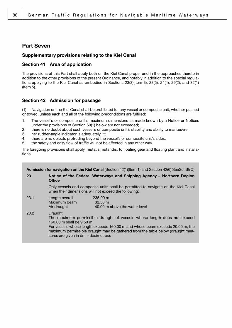
88 G e r m a n T r a f f i c R e g u l a t i o n s f o r N a v i g a b l e M a r i t i m e W a t e r w a y s
Part Seven
Supplementary provisions relating to the Kiel Canal
Section 41 Area of application
The provisions of this Part shall apply both on the Kiel Canal proper and in the approaches thereto in addition to the other provisions of the present Ordinance, and notably in addition to the special regula-tions applying to the Kiel Canal as embodied in Sections 23(3)(Item 3), 23(5), 24(4), 29(2), and 32(1)(Item 5).
Section 42 Admission for passage
(1) Navigation on the Kiel Canal shall be prohibited for any vessel or composite unit, whether pushed or towed, unless each and all of the following preconditions are fulfilled:
1. The vessel’s or composite unit’s maximum dimensions as made known by a Notice or Notices under the provisions of Section 60(1) below are not exceeded;
2. there is no doubt about such vessel’s or composite unit’s stability and ability to manœuvre;3. her rudder-angle indicator is adequately lit;4. there are no objects protruding beyond the vessel’s or composite unit’s sides;5. the safety and easy flow of traffic will not be affected in any other way.
The foregoing provisions shall apply, mutatis mutandis, to floating gear and floating plant and installa-tions.
Admission for navigation on the Kiel Canal (Section 42(1)(Item 1) and Section 42(6) SeeSchStrO)
23 Notice of the Federal Waterways and Shipping Agency – Northern Region Office
Only vessels and composite units shall be permitted to navigate on the Kiel Canal when their dimensions will not exceed the following:
23.1 Length overall 235.00 m Maximum beam 32.50 m Air draught 40.00 m above the water level
23.2 Draught The maximum permissible draught of vessels whose length does not exceed
160.00 m shall be 9.50 m. For vessels whose length exceeds 160.00 m and whose beam exceeds 20.00 m, the
maximum permissible draught may be gathered from the table below (draught mea-sures are given in dm – decimetres):

G e r m a n T r a f f i c R e g u l a t i o n s f o r N a v i g a b l e M a r i t i m e W a t e r w a y s 89
Lengthin m
Beam in m
20 21 22 23 24 25 26 27 28 29 30 31 32 32,50
160 95 95 95 95 95 95 95 95 94 93 92 91 89 89163 95 95 95 95 95 95 95 94 93 92 91 90 89 89166 95 95 95 95 95 95 95 94 93 91 90 89 88 87169 95 95 95 95 95 95 94 93 92 90 89 88 87 86172 95 95 95 95 95 94 93 92 91 90 88 87 86 85175 95 95 95 95 95 94 93 91 90 89 88 86 85 84178 95 95 95 95 94 93 92 90 89 88 87 85 84 83181 95 95 95 94 93 92 91 90 88 87 86 85 83 83184 95 95 95 93 92 91 90 89 87 86 85 84 83 82187 95 95 94 93 91 90 89 88 86 85 84 83 82 81190 95 94 93 92 91 89 88 87 86 84 83 82 81 80193 95 93 92 91 90 89 87 86 85 84 83 81 80 79196 94 93 91 90 89 88 86 85 84 83 82 80 79 78199 93 91 90 89 88 87 85 84 83 82 81 79 78 78202 92 91 90 89 87 86 85 84 82 81 80 79 77 77205 91 90 89 88 86 85 84 83 82 80 79 78 77 76208 90 89 88 87 85 84 83 82 81 80 78 77 76 75211 90 89 87 86 85 84 83 81 80 79 77 76 75 74214 89 88 86 85 84 83 82 80 79 78 76 75 74 74217 88 87 85 84 83 82 80 79 78 77 75 74 74 73220 87 86 84 83 82 81 80 78 77 76 75 74 73 73223 86 85 84 83 81 80 79 77 76 75 74 73 72 72226 85 84 83 82 80 79 78 77 75 74 74 73 72 71229 84 83 82 81 79 78 77 76 74 74 73 72 71 71232 84 83 81 80 79 77 76 75 74 73 72 72 71 70235 83 81 80 79 78 76 75 74 73 73 72 71 70 70
23.3 In individual cases, the passage may be approved of a vessel with a draught of up to 10.40 m in Brunsbüttel from the limit of the approach channel up to kilometric marking 6.0.
23.4 Gieselaukanal Length over all 65.00 m Max. Beam 9.00 m Draught 2.40 m
23.5 Achterwehrer Schifffahrtskanal Length over all 35.00 m Max. Beam 7.50 m Draught 2.00 m up to kilometric marking 2.55 (Roadbridge) 1.40 m from Roadbridge southwards Air draught 20.00 m up to kilometric marking 2.55 (Roadbridge) 4.50 m from Roadbridge southwards
23.6 Mittelstrecke Borgstedter See Draught 7.80 m from the East up to the dolphins of the measu-
ring appliances Air draught 22.50 m above the water level

90 G e r m a n T r a f f i c R e g u l a t i o n s f o r N a v i g a b l e M a r i t i m e W a t e r w a y s
Use of automatic steering appliances (auto-pilots) or closed-circuit re-mote control sys-tems on the Kiel Canal (Section 42(4) SeeSchStrO)
24 Notice of the Federal Waterways and Shipping Agency – Northern Region Office
24.1 The use of automatic steering appliances is allowed for vessels of the traffic catego-ries 1 and 2 only, except composite units, provided that the preconditions under Item 24.2 below are fulfilled.
24.2 The use of automatic steering appliances is permitted only if – the automatic steering appliance is in accordance with the IMO-performence
standards, – the automatic steering appliance works in connection with a gyro-compass, – the vessel is equipped with a single-hand control platform and the automatic
steering appliance is equipped with a override-tiller or -hand wheel, – no radius turning control system will be used, – the automatic steering appliance is able to keep the course presently heading
after switching from manual to automatic steering, – the adjustment of the unit is able to meet the requirements of the district, – a minimum speed of 8 km/h (4.3 kn) can be kept, – the range of visibility is not less than 2 nautical miles and – the unit will be switched to manual operation in good time before overtaking or
head-on situations.
24.3 The use of automatic steering appliance according to the preconditions listed under Item 24.2 do not release a master from other exis-ting regulations.
(2) In the case of a composite unit being towed, arrangements shall be made to ensure that a speed of 9 km per hour (equals 4.9 knots) can be maintained and that at least two persons conversant with navigational matters are on board each non-self-propelled vessel forming part of the composite unit.
(3) Vessels carrying certain dangerous goods in terms of Section 2(1)(Item 16) above shall be identi-fied as such not later than when reporting in for Canal passage as prescribed in Section 43 below. However, this provision shall not apply to warships. The person in command of a tanker having dischar-ged her cargo shall submit, together with his report in for Canal passage, a written declaration to the effect that no inflammable gases are carried aboard. The special list or manifest, respectively the detailed stowage plan, required to be carried under the provisions of regulation VII/5.5 of the Annex to the International Convention for the Safety of Life at Sea, 1974, as embodied in the Ordinance of 11 January 1979 (promulgated in the Federal Law Gazette 1979 II, p 141) and last modified by the Ordi-nance of 24 April 1997 (promulgated in the Federal Law Gazette 1997 II, p 934) shall be kept readily available on the navigating bridge of any vessel carrying dangerous goods of Classes 1 to 9 of the IMDG Code throughout the Canal passage.
(4) The use of automatic steering appliances (auto-pilots) or closed-circuit remote control sys tems shall only be permitted in the circumstances made known by a Notice or Notices under the provisions
(5) Such vessels as have been made known by a Notice or Notices under the provisions of Section 60(1) below shall enlist for the Canal passage the services of a specified number of helmsmen recog-nized by the competent shipping police authority as being reliable and conversant with the conditions prevailing on the Kiel Canal (known as “Canal helmsmen”). However, this provision shall not apply
1. to the stretch of Canal between the Brunsbüttel Locks and Canal km 6.00;2. to the stretch of Canal between the Kiel-Holtenau Locks and the Western limit of the Schwar-
tenbek siding;3. to vessels in the Public Service and to warships.

G e r m a n T r a f f i c R e g u l a t i o n s f o r N a v i g a b l e M a r i t i m e W a t e r w a y s 91
Enlisting the services of Canal helmsmen(Section 42(5) SeeSchStrO)
25 Notice of the Federal Waterways and Shipping Agency – Northern Region Office
When a vessel exceeds any one or more of the following dimensions, she shall enlist the services of Canal helmsmen for the stretches of water as listed hereunder:
25.1 Between Brunsbüttel and Rüsterbergen (pilot transfer station) a length of 100.00 m / 120.00 m a beam of 16.50 m / 14.50 m a draught of 6.10 m / 6.10 m
25.2 Between Rüsterbergen (pilot transfer station) and Kiel-Holtenau a length of 100.00 m / 115.00 m a beam of 15.50 m / 14.00 m a draught of 6.10 m / 6.10 m
25.3 Tankers up to Traffic category 4 and other vessels up to Traffic category 5 with the following maximum dimensions, viz:
a length of 100.00 m / 120.00 m a beam of 19.00 m / 17.00 m a draught of 7.00 m / 7.00 m shall enlist the services of one Canal helmsman. Vessels exceeding any one of these
dimensions shall enlist the services of two Canal helmsmen. However, this provision shall not apply to short trips not exceeding a length of 15 kilometres.
25.4 Values for length and beam should be interpolated according to the rules provideed at 5.2.
(6) The local waterways and shipping office may deny the right of passage through the Canal to a vessel not fulfilling the preconditions laid down in paragraphs (1) to (5) above, or may permit passage only upon certain conditions to be fulfilled.
(7) No vessel shall be permitted to be lying at any location other than a siding, a public port or har-bour, a terminal, or another designated lying site for any reason other than on account of the prevail ing traffic conditions.
Section 43 Reporting in for, and out from, passage through the Kiel Canal
(1) The person in command of a vessel wishing to pass through the Kiel Canal or a person commis-sioned for that purpose by the person in command of such vessel, shall report in for passage to the competent waterways and shipping office immediately upon entering the Brunsbüttel, Kiel-Holtenau, or Gieselau Locks, as the case may be; when reporting in, the documentation made known by a Notice or Notices under the provisions of Section 60(1) below shall be presented.

92 G e r m a n T r a f f i c R e g u l a t i o n s f o r N a v i g a b l e M a r i t i m e W a t e r w a y s
Documentation required for passage through the Kiel Canal (Section 43(1) SeeSchStrO)
26 Notice of the Federal Waterways and Shipping Agency – Northern Region Office
Documentation required to be presented, respectively submitted, when reporting in for passage through the Kiel Canal:
26.1 An application form completed and signed by the master.
26.2 Certificate of Tonnage Measurement, respectively, Gauging Certificate.
26.3 In the case of a vessel other than described in the preceding Item: Cargo documen-tation and other documentation as required.
26.4 A vessel exempted from compulsory pilotage shall carry on board both the exemp-tion certificate and a documentary proof of the identity of such certificate’s holder and shall present these.
(2) When a vessel stops for mooring anywhere on the Kiel Canal without having received an order to do so (stop call), she shall report out from passage to the competent VTS centre. Canal passage may not be commenced or resu-med, as the case may be, until consent to do so has been received from the appropriate VTS centre. Upon receiving such consent, the vessel shall commence, respectively resume, passage without delay. The person in command shall, in complying with the requirements for conduct in traffic, take immediate account of traffic information provided by VTS centres in accordance with the circumstances of the traffic situation prevailing and shall comply with any meas-ures of traffic flow con-trol that may have been imposed.
(3) Vessel may not depert from lying sites in the “Achterwehrer Schifffahrtskanal” without notification of the lock-keeper; this shall not apply to pleas-ure craft.
Section 44 [This Section has been suspended.]
Section 45 Traffic in the approaches to the Kiel Canal
No vessels other than those entering or leaving the Kiel Canal may use the approaches to the Kiel Canal. However, this provision shall not apply
1. to vessels en route to or from the cargo-handling terminal in the Kiel-Holtenau by-port;2. to passenger vessels en route to or from the embarkation/disembarkation site at Kiel-Holtenau;3. to pleasure craft en route to or from approved mooring sites;4. to vessels operated by a shipping police authority, to pilot launches, and to tugs operating with
official approval.

G e r m a n T r a f f i c R e g u l a t i o n s f o r N a v i g a b l e M a r i t i m e W a t e r w a y s 93
Section 46 Right-of-way regulations for vessels entering or leaving locks
(1) The provisions contained in the paragraphs below shall apply in derogation of Rules 9(b) to (d), 15, and 18(a) to (c) of the International Regulations for Preventing Collisions at Sea, 1972, as amended.
(2) At Kiel-Holtenau, a vessel or vessels entering the “Neue Schleuse” Locks from the approaches thereto shall have the right of way over a vessel or vessels leaving the “Alte Schleuse” Locks. At Bruns-büttel, a vessel or vessels leaving by-ports for the approaches thereto shall have the right of way over a vessel or vessels entering these approaches.
(3) Both at Brunsbüttel and at Kiel-Holtenau, a vessel or vessels leaving the “Neue Schleuse” Locks shall have the right of way over a vessel or vessels leaving the “Alte Schleuse” Locks.
Section 47 Ban on entering respectively leaving locks
(1) In restricted visibility, no vessel shall leave the locks for the landward by-ports nor, as far as Kiel-Holtenau is concerned, for the landward or seaward by-port while other vessels are entering the locks from there.
(2) At Brunsbüttel, no vessel shall leave the locks for the seaward by-port while another vessel is entering there from the River Elbe. No vessel of a certain draught shall enter or leave the locks when certain water levels, as made known by a Notice or Notices under the provisions of Section 60(1) below, are prevailing.
Ban on entering respectively leaving the Neue Schleusen Locks at Brunsbüttel (Section 47(2)(second sentence) SeeSchStrO)
27 Notice of the Federal Waterways and Shipping Agency – Northern Region Office
27.1 Table of limiting water levels and draughts for a ban on entering respectively leaving the Neue (Große) Schleusen Locks at Brunsbüttel:
Water level aboveChart Datum (LAT)
Draughtexceeding
Water level aboveChart Datum (LAT)
Draughtexceeding
+1.40 m 10.40 m +0.60 m 9.60 m
+1.30 m 10.30 m +0.50 m 9.50 m
+1.20 m 10.20 m +0.40 m 9.40 m
+1.10 m 10.10 m +0.30 m 9.30 m
+1.00 m 10.00 m +0.20 m 9.20 m
+0.90 m 9.90 m +0.10 m 9.10 m
+0.80 m 9.80 m +0.00 m 9.00 m
+0.70 m 9.70 m
27.2 Table of limiting water levels and draughts for a ban on entering respectively leaving the Alte (Kleine) Schleusen Locks at Brunsbüttel:
Water level aboveChart Datum (LAT)
Draughtexceeding
Water level aboveChart Datum (LAT)
Draughtexceeding
+1.00 m 6.50 m +0.50 m 6.00 m
+0.90 m 6.40 m +0.40 m 5.90 m
+0.80 m 6.30 m +0.30 m 5.80 m
+0.70 m 6.20 m +0.20 m 5.70 m
+0.60 m 6.10 m +0.10 m 5.60 m

94 G e r m a n T r a f f i c R e g u l a t i o n s f o r N a v i g a b l e M a r i t i m e W a t e r w a y s
Section 48 Minimum safe distances between vessels
(1) At locations other than the sidings and locks forming part of the Kiel Canal – except for stretches of water extending for a length of 1000 metres in front of, and 2000 metres behind, the limits of sidings –
1. vessels of vessel categories 1, 2, and 3 shall keep a distance of not less than 600 metres2. vessels of vessel categories 4 and above shall keep a distance of not less than 1000 metres from
any vessel navigating in front of them, unless they are in an overtaking situation as described in Section 23(4) or (5) above.
(2) The minimum safe distance to be kept from vessels of less than 20 metres in length may be less than that prescribed in the foregoing paragraph.
Section 49 Conduct of vessels in front of, and in, sidings
(1) Vessels shall enter sidings expeditiously.
(2) Where one of the visual signs described under Item A.22(b) of Annex I to the present Ordinance is exhibited in a siding, a vessel under a ban on leaving such siding shall, under the existing circumstan-ces, moor to the foremost accessible dolphin lying to the starboard side of the vessel as she would proceed, or stop in its vicinity and leave adequate room for transiting vessels. Only when traffic or wea-ther conditions so require, a vessel may, exceptionally, moor to the foremost accessible dolphin lying to the port side of the vessel as she would proceed.
(3) The sequence of vessels for leaving a given siding shall, as a rule, be governed by the sequence of vessels when entering that siding. When a vessel wishes to overtake another vessel lying moored, in front of herself, in the same row of dolphins and having been authorized to proceed, the persons in command of the two vessels shall bring about an understanding between themselves in accordance with the provisions of Section 23(4) above. This provision shall also apply to cases where vessels ente-ring a given siding wish to overtake other vessels lying moored in that siding in the same direction of traffic and having been authorized to proceed. Sailing past vessels lying moored to dolphins without such vessels being authorized to proceed shall not be regarded as overtaking.
(4) Vessels lying moored to dolphins on their port side shall not depart unless it is certain that no vessels on a through passage nor vessels departing from dolphins on their starboard side will be put at any risk or be impeded.
(5) No vessel shall be permitted to be lying in a siding for any reason other than on account of the prevailing traffic or weather conditions unless upon prior consent by the competent VTS centre.
Section 50 Sailing rules for vessels exempt from compulsory pilotage and for composite units
(1) No vessel exempt from compulsory pilotage shall navigate on the Kiel Canal in restricted visibility unless
1. the vessel’s radar is in efficient working order and2. one person conversant with the operation of the radar is present on the navigating bridge in addi-
tion to the person in command of the vessel.
Where the above preconditions are not fulfilled, the vessel shall discontinue her passage through the Canal and proceed to the nearest siding for mooring, and she shall do so, whenever possible, behind the dolphins or at the nearest desig-nated mooring site.

G e r m a n T r a f f i c R e g u l a t i o n s f o r N a v i g a b l e M a r i t i m e W a t e r w a y s 95
(2) Vessels exempt from compulsory pilotage and composite units not fulfilling the preconditions specified for night passage through the Kiel Canal shall navigate on the Kiel Canal only during such hours as have been made known by a Notice or Notices under the provisions of Section 60(1) below (known as “daylight navigating hours”).
At other times,
1. entering the locks from the landward by-ports and leaving the locks for the landward by-ports,2. the onward passage for the “Kreishafen Rendsburg” Port (in cases where the Breiholz siding, res-
pectively the Audorf/Rade siding, will have been reached before the lapse of daylight navigating hours), and
3. the onward passage to the respective exit locks (in cases where the Dückerswisch siding, respec-tively the Groß-Nordsee siding, will have been reached before the lapse of daylight navigating hours)
shall be permitted.
“Daylight navigating hours“ for the purposes of navigation on the Kiel Canal (Section 50(2) SeeSchStrO)
28 Notice of the Federal Waterways and Shipping Agency – Northern Region Office
“Daylight navigating hours” (given in Legal Time) and vessel categories not fulfilling the preconditions specified for night passage through the Kiel Canal:
28.1 Daylight navigating hours 01.01. to 15.01. 07.30 to 17.00 hrs 16.01. to 31.01. 07.30 to 17.30 hrs 01.02. to 15.02. 07.00 to 18.00 hrs 16.02. to 28./29.02. 06.30 to 18.30 hrs 01.03. to 15.03. 05.30 to 19.00 hrs 16.03. to 31.03. 05.00 to 19.30 hrs 01.04. to 15.04. 04.30 to 20.00 hrs 16.04. to 30.04. 04.00 to 20.30 hrs 01.05. to 15.05. 03.30 to 21.00 hrs 16.05. to 31.05. 03.00 to 21.30 hrs 01.06. to 30.06. 02.30 to 22.00 hrs 01.07. to 15.07. 02.30 to 22.00 hrs 16.07. to 31.07. 03.00 to 21.30 hrs 01.08. to 15.08. 03.30 to 21.00 hrs 16.08. to 31.08. 04.00 to 20.30 hrs 01.09. to 15.09. 04.30 to 20.00 hrs 16.09. to 30.09. 05.00 to 19.30 hrs 01.10. to 15.10. 05.30 to 19.00 hrs 16.10. to 31.10. 06.00 to 18.30 hrs 01.11. to 15.11. 06.30 to 17.30 hrs 16.11. to 30.11. 07.00 to 17.00 hrs 01.12. to 31.12. 07.30 to 17.00 hrs During Central European Summer Time, the above “daylight navigating hours” will
begin and end one hour earlier.
28.2 Vessel categories not fulfilling the preconditions specified for night passage through the Kiel Canal:
Composite units being towed of vessel category 4 and above, plus those composi-te units being towed as well as those vessels exempted from compulsory pilotage and incapable of keeping a minimum speed over ground of 15 km/h (equals 8.1 knots) or incapable of complying with the requirement of maintaining a conti-nuous radio-telephone link.

96 G e r m a n T r a f f i c R e g u l a t i o n s f o r N a v i g a b l e M a r i t i m e W a t e r w a y s
(3) Vessels of vessel category 1, when exempt from compulsory pilotage, shall not tow more than one pleasure craft of up to 15 metres in length and may do so only during daylight navigating hours; such composite unit being towed shall be deemed a single vessel for the purposes of traffic flow con-trol.
(4) In restricted visibility or in a storm, composite units being towed shall discontinue their passage through the Canal and shall, whenever possible, proceed to a siding for mooring.
Section 51 Sailing rules for pleasure craft
(1) Pleasure craft may use the approaches to the Kiel Canal and the Kiel Canal proper only for the purpose of passing through the Canal during the daylight navigating hours in terms of Section 50(2) above, but they shall not do so at any time when visibility is restricted. However, this provision shall not apply to pleasure craft with a pilot embarked or heading for those mooring sites in the Kiel-Holtenau seaward by-port and in the Brunsbüttel landward by-port where pleasure craft are admitted for moo-ring, nor shall this provision apply to pleasure craft having applied to the Brunsbüttel Lock-keeper to be let out of the locks for the River Elbe.
(2) Pleasure craft which have their home mooring on the Kiel Canal or which are laid ashore in the immediate vicinity of the Kiel Canal – in both cases, “the Kiel Canal” meaning the Kiel Canal between the Brunsbüttel and the Kiel-Holtenau Locks – shall require a navigating permit (the German term being “Fahrtausweis”) when they wish to navigate on the Kiel Canal; such navigating permit may be obtained from the competent waterways and shipping office.
(3) Pleasure craft shall make arrangements for their Canal passage to take place so as to en able them to reach a dedicated mooring site for pleasure craft before the lapse of daylight navigating hours.
(4) When, unexpectedly, visibility gets reduced, pleasure craft may moor in sidings behind the dol-phins. This provision shall also apply to pleasure craft being towed by a vessel of vessel category 1 being exempt from compulsory pilotage.
(5) Wind-sailing shall be prohibited on the Kiel Canal. However, this provision shall not apply
1. to the Kiel-Holtenau seaward by-port off the “Alte Schleuse” Locks;2. to waters outside the fairway on the Borgstedter See, the Audorfer See, and the Obereidersee.
Power-driven pleasure craft may set their sails in addition to having their engines in operation.
(6) A power-driven pleasure craft may tow only one other pleasure craft, provided that such pleasure craft being towed is less than 15 metres in length. The minimum speed of such a composite unit shall be not less than 9 km per hour (equals 4.9 knots).
Section 52 [This Section has been suspended.]
Section 53 Navigating and mooring on the Gieselaukanal
(1) Navigating on the Gieselaukanal shall be permitted only during the daylight navigating hours in terms of Section 50(2) above.
(2) Pleasure craft may moor overnight for only one night and may do so only at the designated moo-ring site located to the South of the “Gieselauschleuse” Locks.
Section 54 [This Section has been suspended.]

G e r m a n T r a f f i c R e g u l a t i o n s f o r N a v i g a b l e M a r i t i m e W a t e r w a y s 97
Part Eight
Competences and responsibilities of the Federal Waterways and Shipping Administration
Section 55 Shipping police authorities
(1) For the purposes of the present Ordinance, shipping police authorities shall be the Federal Water-ways and Shipping Agency – Northern and North Western Region Offices with their subordinate water-ways and shipping offices; in the exercise of their functions, they shall make use of the services of the Water Police of the coastal states in accordance with the agreements between the Federation and the tates on the exercise of shipping police law-enforcement missions as well as of the services of the Federal Border Guard and the Federal Customs Administration in accordance with Section 3(2) of the Maritime Navigation (Federal Competences) Act.
(2) Waterways and shipping offices shall take shipping police measures of local relevance. When a certain measure has effects reaching beyond the area of competence of one waterways and shipping office, the office in whose area of competence the matter to be dealt with occurs first shall be competent. In derogation of this principle, the competent Federal Waterways and Shipping Agency office may confer upon any specific waterways and shipping office the competence for any specific task on a specific waterway. When a certain measure has effects reaching beyond the area of competence of one Federal Waterways and Shipping Agency office, the waterways and shipping office in whose area of competence the matter to be dealt with occurs first shall be competent. When a certain measure is of fundamental relevance, it shall be taken by the competent Federal Waterways and Shipping Agency office. Shipping police measures that will not allow for any delay may also be taken by the Water Police.
Section 55a Vessel Traffic Services centres (VTS centres)
In the framework of the maritime traffic control system established in accordance with the requirements of the traffic situation in a given maritime district, VTS centres shall be responsible for providing the following:
1. traffic information;2. traffic assistance;3. traffic instructions;4. traffic flow control on the Kiel Canal.
Section 56 Shipping police orders
(1) In fulfilling their commitments under Section 3 of the Maritime Navigation (Federal Competences) Act, shipping police authorities may issue orders containing a requirement (requirements) or prohibition (prohibitions); such shipping police orders may be addressed to specified persons or to a specified group or groups of persons.
(2) Shipping police orders shall have precedence both over the provisions of the present Ordinance and over the requirements embodied in signs and signals.

98 G e r m a n T r a f f i c R e g u l a t i o n s f o r N a v i g a b l e M a r i t i m e W a t e r w a y s
Section 57 Shipping police permits
(1) The organization of the following events shall require a prior permit by the competent waterways and shipping office, the question of competence being governed by the provisions of Section 55(2) above:
1. the navigation of extraordinarily large vessels, air cushion craft, hovercraft, surface-effect craft and high-speed craft as well as of seaplanes and flying boats outside of approved airfields under Section 6 of the air traffic law and outside of starting and landing areas under Section 25 of the air traffic law;
2. the navigation of extraordinary composite units, whether pushed or towed, and the towing of ext-raordinary floating objects;
3. shipyard launches;4. the salvage of vessels, extraordinary floating objects, flotsam and jetsam, if such salvage is lia ble
to affect the safety and easy flow of traffic or to pose a hazard to the marine environment (howe-ver, this provision shall not apply when the competent shipping police authority has ordered such salvage);
5. tests and trials for the towing strength of vessels as well as stationary tests and trials liable to affect the safety and easy flow of traffic;
6. water-sport events taking place on the water;6a. parasailing;7. other events on or along navigable waterways liable to affect the safety and easy flow of traffic or
to pose a hazard to the marine environment.
(2) Any such permit shall be applied for in good time.
(3) Any such permit may be granted with conditions and restrictions attached for the purposes of (a) avoiding or balancing off any cause liable to affect the safety and easy flow of traffic, (b) preventing the noxious effects upon the environment – in terms of the Noxious Immissions
(Protection) (Federal Requirements) Act – that may arise from the operation of the vessel or vessels involved, or
(c) avoiding, preventing, or removing a hazard to the marine environment.
Any such permit shall be granted for an appropriate length of time.
Section 58 Shipping police reports
(1) Masters of a vessel or of a pushing or towing convoy exceeding the dimensions and tonnages made known under the provisions of Section 60(1) below as well as masters of a vessel as defined by Section 30(1) above shall transmit the following information to the VTS centre made known under the provisions of Section 60(1) below:
1. Provided that the particulars listed hereunder have not yet been reported under the provisions of Section 1(1) above in conjunction with the provisions of Item 2.6 of the Annex to Section 1(1) of the Internal Waters (Entering Requirements) Ordinance, the following particulars shall be reported in good time before entering any one of the navigable waterways made known under the provisi-ons of Section 60(1) below:
(a) the vessel’s name, distinctive number or letters and, where appropriate, the IMO ship identifi-cation number or maritime mobile service identity (MMSI) number, and the type of vessel;
(b) the position of the vessel; (c) the length, breadth and current fresh-water draught of the vessel (in metres); (d) the vessel’s last port of departure and next port of call; (e) a statement either indicating whether or not the vessel carries bulk cargoes as defined by
Section 30(1) no. 1 above and, if so, the specification of the type and quantity of such bulk cargoes including the UN number, or indicating whether or not such bulk cargoes have been carried and the thanks have been cleaned and de-gassed or completely inerted afterwards;

G e r m a n T r a f f i c R e g u l a t i o n s f o r N a v i g a b l e M a r i t i m e W a t e r w a y s 99
(f) a statement indicating wether any dangerous goods or goods damaging to the environment in accordance with the Annex to Section 1(1) of the Internal Waters (Entering Requirements) Ord-ninace are carried on board;
(g) a statement indicating whether there are any deficiencies with regard to the vessel or her car-go;
(h) the total number of persons on board.
2. As the vessel proceeds en route past the reporting positions made known under the provisions of Section 60(1) below, the following particulars shall be reported:
(a) the vessel’s name and distinctive number or letters; (b) the position of the vessel; (c) the speed of the vessel; (d) the time of the vessel’s passage.
3. Any discontinuation and subsequent resumption of the vessel’s voyage shall be reported.
Shipping police reports (Section 58(1) SeeSchStrO)
All vessels in terms of Section 30(1) SeeSchStrO as well as those vessels and composite units that exceed any one or more of the dimensions specified below shall be subject to compulsory reporting.
As far as the navigable waterways listed below are concerned, reports shall be addressed to the competent Vessel Traffic Centre through the appropriate VHF channel in accordance with Sec-tion 58(1)(Item 1) – Pre-entry Report – and Section 58(1)(Item 2) – Position Report:
North Sea
19 Notice of the Federal Waterways and Shipping Agency – North Western Region Office
19.1 Inner German Bight
19.1.1 Length: 50.00 m
19.1.2 Wilhelmshaven Traffic Control Centre via VHF channel 79, 80 German Bight Traffic
19.1.3 Pre-entry Report
to be made by vessels navigating in the Traffic Separation Scheme “Terschelling – German Bight” and the associated Inshore Traffic Zone when passing Light-buoy “Borkumriff”
via VHF channel 79 German Bight Traffic
19.1.4 Position Report
to be made by eastbound vessels navigating in the Traffic Separation Scheme “Ter-schelling – German Bight” and the associated Inshore Traffic Zone when passing Light-buoy TG/C
via VHF channel 80 German Bight Traffic
19.2 River Jade
19.2.1 Length: 50.00 m
19.2.2 Wilhelmshaven Traffic Control Centre for the stretch of water between Buoy 1b/Jade and the Buoys 33/34 via VHF channel 63 Jade Traffic for the stretch of water between the Buoys 33/34 and Buoy 58 via VHF channel 20 Jade Traffic
19.2.3 Pre-entry Report when entering the Jade Estuary (unless a report according to 19.1.3 has been
made), or prior to leaving the “Seeschleuse“ Locks or the terminal, with mooring lines still fast.
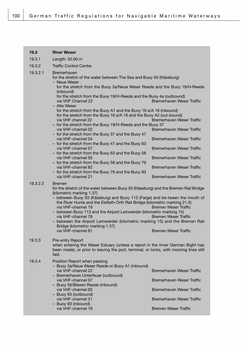
100 G e r m a n T r a f f i c R e g u l a t i o n s f o r N a v i g a b l e M a r i t i m e W a t e r w a y s
19.3 River Weser
19.3.1 Length: 50.00 m
19.3.2 Traffic Control Centre
19.3.2.1 Bremerhaven for the stretch of the water between The Sea and Buoy 93 (Käseburg) – Neue Weser for the stretch from the Buoy 3a/Neue Weser Reede and the Buoy 19/H-Reede
(inbound) for the stretch from the Buoy 19/H-Reede and the Buoy 4a (outbound) via VHF Channel 22 Bremerhaven Weser Traffic – Alte Weser for the stretch from the Buoy A1 and the Buoy 16 a/A 16 (inbound) for the stretch from the Buoy 16 a/A 16 and the Buoy A2 (out-bound) via VHF channel 22 Bremerhaven Weser Traffic – for the stretch from the Buoy 19/H-Reede and the Buoy 37 via VHF-channel 02 Bremerhaven Weser Traffic – for the stretch from the Buoy 37 and the Buoy 47 via VHF-channel 04 Bremerhaven Weser Traffic – for the stretch from the Buoy 47 and the Buoy 63 via VHF-channel 07 Bremerhaven Weser Traffic – for the stretch from the Buoy 63 and the Buoy 58 via VHF-channel 05 Bremerhaven Weser Traffic – for the stretch from the Buoy 58 and the Buoy 79 via VHF-channel 82 Bremerhaven Weser Traffic – for the stretch from the Buoy 79 and the Buoy 93 via VHF-channel 21 Bremerhaven Weser Traffic
19.3.2.2 Bremen for the stretch of the water between Buoy 93 (Käseburg) and the Bremen Rail Bridge
(kilometric marking 1.37) – between Buoy 93 (Käseburg) and Buoy 113 (Farge) and be-tween the mouth of
the River Hunte and the Elsfleth-Orth Rail Bridge (kilometric marking 21.0) via VHF-channel 19 Bremen Weser Traffic – between Buoy 113 and the Airport Lemwerder (kilometric marking 15) via VHF-channel 78 Bremen Weser Traffic – between the Airport Lemwerder (kilometric marking 15) and the Bremen Rail
Bridge (kilometric marking 1.37) via VHF-channel 81 Bremen Weser Traffic
19.3.3 Pre-entry Report when entering the Weser Estuary (unless a report in the Inner German Bight has
been made), or prior to leaving the port, terminal, or locks, with mooring lines still fast.
19.3.4 Position Report when passing – Buoy 3a/Neue Weser Reede or Buoy A1 (inbound) via VHF-channel 22 Bremerhaven Weser Traffic – Bremerhaven Unterfeuer (outbound) via VHF-channel 07 Bremerhaven Weser Traffic – Buoy 56/Blexen Reede (inbound) via VHF-channel 05 Bremerhaven Weser Traffic – Buoy 93 (outbound) via VHF-channel 21 Bremerhaven Weser Traffic – Buoy 93 (inbound) via VHF-channel 19 Bremen Weser Traffic

G e r m a n T r a f f i c R e g u l a t i o n s f o r N a v i g a b l e M a r i t i m e W a t e r w a y s 101
– Elsfleth-Orth Rail Bridge (kilometric marking 21.0) (out-bound) via VHF-channel 19 Bremen Weser Traffic – Buoy 111 (Farge) via VHF-channel 19 Bremen Weser Traffic – Moorlosen Kirche (kilometric marking 12.5) via VHF-channel 81 Bremen Weser Traffic
19.4 River Hunte
19.4.1 Length: 50.00 m
19.4.2 Vessel Traffic Centre Bremen for the stretch of the water between Oldenburg (kilometric marking 0.0) and the
Elsfleth-Orth Rail Bridge (kilometric marking 21.0) via VHF-channel 63 Hunte Traffic
19.4.3 Pre-entry Report when entering the River Hunte or prior to leaving the port or terminal with mooring
lines still fast.
19.4.4 Position Report when passing – Elsfleth-Orth Rail Bridge (kilometric marking 21.0) – Oldenburg - Drielake (kilometric marking 1.8) via VHF channel 63 Hunte Traffic
29 Notice of the Federal Waterways and Shipping Agency – Northern Region Office
29.1 River Elbe
29.1.1 Length overall from 50.00 m
29.1.2 Vessel Traffic Centres
29.1.2.1 Cuxhaven For the stretch of the water between Buoy Elbe and the Buoys 53, 54/Reede via VHF channel 71 Cuxhaven ElbeTraffic
29.1.2.2 Brunsbüttel For the stretch from the Buoys 53, 54/Reede and the Buoy 125 via VHF channel 68 Brunsbüttel ElbeTraffic
29.1.3 Pre-entry Report Vessels having already made their Pre-entry Report via German Bight Traffic, Kiel
Canal Traffic or Hamburg Port Traffic shall be exempt from this particular reporting duty. Otherwise, the report shall be made, respectively,
– prior to leaving the locks of the Kiel Canal at Brunsbüttel; – prior to leaving the port or lying site, with mooring lines still fast.
29.1.4 Position Report when passing Inbound – Buoy Elbe via VHF channel 71 Cuxhaven Elbe Traffic – Buoys 53, 54/Reede via VHF channel 68 Brunsbüttel Elbe Traffic – Buoy 125 via VHF channel 14 Hamburg Port Traffic outbound – Buoy 125 via VHF channel 14 Hamburg Port Traffic and via VHF channel 68 Brunsbüttel Elbe Traffic – Buoys 53, 54/Reede via VHF channel 71 Cuxhaven Elbe Traffic

102 G e r m a n T r a f f i c R e g u l a t i o n s f o r N a v i g a b l e M a r i t i m e W a t e r w a y s
– Buoy Elbe via VHF channel 80 German Bight Traffic outbound from the Kiel Canal – when passing the outer lock gates via VHF channel 68 Brunsbüttel Elbe Traffic
29.2 Kiel Canal
29.2.1 All vessels, except for pleasure craft with a length overall of less than 15.00 m.
29.2.2 Vessel Traffic Centres
29.2.2.1 Nord-Ostsee-Kanal I for the canal stretch between Brunsbüttel and Breiholz (west stretch)
via VHF channel 02 Kiel Canal II
29.2.2.2 Nord-Ostsee-Kanal II for the canal stretch between Breiholz to Kiel-Holtenau (east stretch)
via VHF channel 03 Kiel Canal III
29.2.3 Pre-entry Report – Before leaving a port/lying site, with mooring lines still fast.
29.2.4 Every vessel equipped with a VHF radiotelephone installation shall maintain a con-tinuous radiotelephone link while underway on any one of the stretches of water listed hereunder:
29.2.4.1 Approach and outer harbours Brunsbüttel Inbound via VHF channel 13 Kiel Canal I Outbound via VHF channel 68 Brunsbüttel Elbe Traffic Locks Brunsbüttel via VHF channel 13 Kiel Canal I
29.2.4.2 Canal stretch between Brunsbüttel and Breiholz via VHF channel 02 Kiel Canal II
29.2.4.3 Canal stretch between Breiholz and Kiel-Holtenau via VHF channel 03 Kiel Canal III
29.2.4.4 Locks, outer harbours and approach Kiel-Holtenau via VHF channel 12 Kiel Canal IV
Baltic Sea
29.3 Kieler Förde
29.3.1 – Length overall of 50.00 m and above. – Vessels, composite units, and floating gear with a mast, superstructure, or arm
height of more than 40.00 m and wishing to use the Holtenauer Reede Road or the water surface situated immediately to the North-West of this Road and being delimited, to the North and the West, by the shoreline and, to the South, by the Stickenhörn Jetty.
29.3.2 Vessel Traffic Centre Travemünde via VHF channel 67 Kiel Traffic
29.3.3 Pre-entry Report – Inbound vessels shall report 60 minutes prior to passing Kiel Lighthouse, – Outbound vessels shall report prior to leaving the port/lying site/lock, with moo-
ring lines still fast, via VHF channel 67 Kiel Traffic

G e r m a n T r a f f i c R e g u l a t i o n s f o r N a v i g a b l e M a r i t i m e W a t e r w a y s 103
29.3.4 Position Report – when passing Kiel Lighthouse – upon arrival in harbour/at lying site – upon arrival at and when leaving a roadstead via VHF channel 67 Kiel Traffic
29.3.5 Position Report when bound for the Kiel Canal – from seawards when passing Friedrichsort Lighthouse – leaving the harbour when passing harbour limits via VHF channel 12 Kiel Kanal IV
29.4 River Trave
29.4.1 – Maximum beam 6.00 m and above
– Vessels, composite units and other and other equipment having a maximum height of 30 m or more which intend to navigate the „Herrendurchstich“ passage (Trave km 13.6 to14.2)
29.4.2 Vessel Traffic Centre Travemünde via VHF channel 13 Trave Traffic
29.4.3 Pre-entry Report Inbound – when passing Light-buoy 1 Lübeck-Gedser-Weg outbound – Before leaving a port/lying site, with mooring lines still fast.
29.4.4 Position Report when passing Inbound – Approach Buoy Trave – Light-buoy 1 – Light pole 16 – Light pole 22 outbound – Light pole 36 – Light pole 16 – Priwall South
29.5 Approach to Port of Wismar
29.5.1 Maximum beam 6.00 m and above
29.5.2 Vessel Traffic Centre Travemünde via VHF channel 12 Wismar Traffic29.5.3 Pre-entry Report Inbound – one hour prior to passing Approach Buoy Wismar or Approach Buoy Offentief outbound – Before leaving a port/lying site, with mooring lines still fast.
29.5.4 Position Report when passing inbound – Approach Buoys Wismar or Offentief – after pilot embarkation and when proceeding with the voyage – Buoys 9/10 with notice if using Flaggtief – Buoy 23/20 outbound – Buoy 23/20 with notice if using Flaggtief – Buoy 9/10 – Approach Buoys Wismar or Offentief

104 G e r m a n T r a f f i c R e g u l a t i o n s f o r N a v i g a b l e M a r i t i m e W a t e r w a y s
29.6 River Warnow
29.6.1 Length overall 30.00 m and above
29.6.2 Vessel Traffic Centre Warnemünde via VHF channel 73 Warnemünde Traffic
29.6.3 Pre-entry Report inbound – 30 minutes prior to sail the Rostock fairway outbound – Before leaving a port/lying site, with mooring lines still fast.
29.6.4 Position Report when passing in- and outbound – after pilot embarkation and when proceeding with the voyage – Buoys 1 and 2 or when entering the Rostock fairway – the jetties – turning basin (Wendeplatte) with notice of beginning and ending of the turning
manoeuvre – Berth 60 Überseehafen – Marienehe Fairway – Leaving the fairway and after mooring
29.7 Northern Approach to Stralsund
29.7.1 Length overall 20.00 m and above
29.7.2 Vessel Traffic Centre Warnemünde via VHF channel 67 Stralsund Traffic
29.7.3 Pre-entry Report inbound – 30 minutes prior to passing Approach Buoy Gellen outbound – Before leaving a port/lying site, with mooring lines still fast.
29.7.4 Position Report when passing in- and outbound – Approach Buoy Gellen – after pilot embarkation and when proceeding with the voyage – Buoy 30 – Buoy 48 – Ziegelgrabenbrücke/Strelasundbrücke – Leaving the fairway and after mooring
29.8 Eastern approach to Greifswalder Bodden (Landtief to Palmer Ort channel buoys 3 and 4)
29.8.1 Length overall 20.00 m and above
29.8.2 Vessel Traffic Centre Warnemünde via VHF channel 09 Wolgast Traffic
29.8.3 Pre-entry Report inbound – 30 minutes prior to passing the Buoy Landtief B – passing Buoys 3 and 4 (Palmer Ort Rinne) outbound – before leaving a port/lying site, with mooring lines still fast.
– passing Buoys 3 and 4 (Palmer Ort Rinne)
G e r m a n T r a f f i c R e g u l a t i o n s f o r N a v i g a b l e M a r i t i m e W a t e r w a y s 105
29.8.4 Position Report when passing in- and outbound – after pilot embarkation and when proceeding with the voyage – Buoy Landtief B – Buoy L 11 indicating port of destination and intended fairway – Leaving the fairway and after mooring
29.9 Eastern approach to Stralsund ( Palmer Ort channel buoys 3 and 4 to Stral-sund)
29.9.1 Length overall 20.00 m and above
29.9.2 Vessel Traffic Centre Warnemünde via VHF channel 09 Stralsund Traffic
29.9.3 Pre-entry Report inbound – passing Buoys 3 and 4 (Palmer Ort Rinne) outbound – Before leaving a port/lying site, with mooring lines still fast
– passing Buoys 3 and 4 (Palmer Ort Rinne)
29.9.4 Position Report when passing in- and outbound – Buoy 17 – Buoy 34 – Ziegelgrabenbrücke/Strelasundbrücke – Leaving the fairway and after mooring
29.10 Peenestrom water including the Osttief
29.10.1 Length overall 20.00 m and above
29.10.2 Vessel Traffic Centre Warnemünde via VHF channel 09 Wolgast Traffic
29.10.3 Pre-entry Report inbound – 30 minutes prior to passing the Approach Buoy Osttief or the Buoy Haff outbound – Before leaving a port/lying site, with mooring lines still fast.
29.10.4 Position Report when passing in- and outbound – Approach Buoy Osttief – from or in direction Landtiefrinne at Buoy L11 – Buoy PN5/KR13 indicating port of destination and intented fairway – Road bridge Zecherin – Buoy Peenestrom Süd/H 1 – Buoy Haff – Leaving the fairway and after mooring
29.11 Approaches to the Ports of Sassnitz
29.11.1 Length overall 50.00 m and above
29.11.2 Vessel Traffic Centre Warnemünde via VHF channel 13 Sassnitz Traffic

106 G e r m a n T r a f f i c R e g u l a t i o n s f o r N a v i g a b l e M a r i t i m e W a t e r w a y s
29.11.3 Pre-entry Report inbound – when passing the Buoys Sassnitz or Mukran at the reporting point shown on the
chart outbound – before leaving a port/lying site, with mooring lines still fast.
(2) Having transmitted the initial report via VHF radiotelephone, the master of a vessel as defined by paragraph (1) above shall keep a continuous listening watch on the VHF channels made known under the provisions of Section 60(1) below and, when technically feasible, also on VHF channel 16, so that the ompetent shipping police authority can at all times address the vessel in question.
(3) Where vessels are fitted with AIS and operate in an area made known under the provisions of Section 60(1) below, their mnasters shall submit the reports required by paragraph 1 nos. 1 and 2 via AIS. In addition, the vessel’s name and position have to be reported via VHF radiotelephone.
Section 59 Exemptions
On a case-by-case basis, shipping police authorities may grant exemptions from any one or more the provisions of the present Ordinance.
Section 60 Authorization to issue shipping police notices and ordinances
(1) By virtue of the present Ordinance, the authority is conveyed upon the Waterways and Shipping Directorates North and Northwest to issue, for their respective areas of responsibility, Notices as provi-ded for in the foregoing provisions to the extent necessary to prevent hazards to the safety and effici-ency of navigation and to the maritime environment, or to prevent adverse environmental impacts of shipping within the meaning of the Federal Ambient Pollution Control Act. Any such Notices shall be promulgated in the “Bundesanzeiger“ (Federal Gazette) .
(2) By virtue of the present Ordinance, the authority is conveyed upon the Waterways and Shipping Directorates North and Northwest to issue, for their respective areas of responsibility, Ordinances governing the delimitation of both military and civilian training areas and restricted/prohibited zones as well as the conduct of vessels in relation thereto.
(3) By virtue of the present Ordinance, the authority is conveyed upon the Waterways and Shipping Directorates North and Northwest to issue, for their respective areas of responsibility, Ordinances covering the issuance of orders of a temporary nature, for a period of maximally three years, as may become necessary for particular reasons to ensure the safety and efficiency of navigation on navigable waterways and to prevent hazards to the marine environment or adverse environmental impacts of shipping within the meaning of the Federal Ambient Pollution Control Act. Such Ordinances may be issued, in particular, with respect to work being undertaken in waterways, public events being held, or prevailing fairway conditions. The first sentence of the present paragraph shall also apply to Ordinan-ces enabling shipping police to take measures pending an amendment to the present Ordinance or measures being tested.

G e r m a n T r a f f i c R e g u l a t i o n s f o r N a v i g a b l e M a r i t i m e W a t e r w a y s 107
Part Nine
Provisions on administrative fines and on matters of competence
Section 61 Administrative offences
(1) An administrative offence shall be deemed to have been committed, in terms of Section 15(1)(Item 2) of the Maritime Navigation (Federal Competences) Act or in terms of Section 7(1) of the Inland Navi-gation (Federal Competences) Act, as appropriate, by any person doing, respectively failing to do, any of the following, whether with intent or by negligence or recklessness:
1. failing – contrary to the provisions of Section 3(1) Sentence 1 – to act in such a way as to avoid any other person to be exposed to any damage or detriment, to be put at risk, or to be impeded or molested any more than is inevitable in the circumstances prevailing;
1a) navigating a vessel, performing other bridge, deck or machinery services, riding a jetbike, kite-surfing or wind-surfing – contrary to the provisions of Section 3(3) above – although he or she is impaired in his or her ability to safely navigate a vessel or safely perform such bridge, deck or machinery services as a result of physical or mental deficiencies or the intake of alco-holic beverages or other intoxicating substances;
1b) navigating a vessel, performing other bridge, deck or machinery services, riding a jetbike, kite-surfing or wind-surfing – contrary to the provisions of Section 3(4) above – although he or she has a breath alcohol content of 0.25 mg/l or more or a blood alcohol content of 50 mg/100 ml or more or after an intake of alcohol that may lead to such a breath or blood alcohol content;
1c) consuming alcoholic beverages during the journey or being under the influence of such beve-rages at the start of work – contrary to the provisions of Section 3(5) above;
2. contravening the provisions of Section 4(2) above on the provision by pilots of advice to the per-son in command of the vessel, or the provisions of Section 4(4) above on the designation of a person to be in command of a given vessel;
3. failing – contrary to the provisions of Section 5(2) above – to comply with orders given by means of signs or signals for navigational purposes, embodying requirements or prohibitions;
4. damaging – contrary to the provisions of Section 5(3) above – signs or signals for navigational purposes or affecting their capability of being discerned and identified;
5. contravening any one or more of the provisions of Section 6 above on the use of visual and sound signals, lanterns, lights, and searchlights, on the equipment of vessels with sound-signalling appliances, and on ensuring their efficiency and operational safety;
6. contravening any one or more of the provisions of Section 8 above on the carriage or the placing, the horizontal distribution of light, the range of visibility, or the properties (such as shape, colour, or size) of visual signs;
7. using – contrary to the provisions of Section 9(1) above – any navigation lights or sound-signalling appliances that have not been type-approved by the Federal Maritime and Hydrographic Agency; failing – contrary to the provisions of Section 9(1)(second sentence) above – to have properly repaired, respectively replaced, any navigation lights the effectiveness or operational reliability of which is affected in any way, or failing to do so in good time; using – contrary to the provisions of Section 9(2) (first sentence) above – any non-electric navigation lights; using – contrary to the provisions of Section 9(4) (first sentence) above – any navigation lights other than those described in the said provisions or other than those permitted to be used under the appropriate provisions of the International Regulations for Preventing Collisions at Sea, 1972, as amended; failing – con-trary to the provisions of Section 9(4)(second sentence) above – to have properly repaired, res-pectively replaced, any navigation lights the effectiveness or the operational reliability of which is affected in any way, or failing to do so in good time;
8. contravening any one or more of the provisions of Section 10(1), (2), and (5) above on the exhibi-tion of visual signs, or violating a ban on vessels to be underway in the circumstances set out in Section 10(3) above;

108 G e r m a n T r a f f i c R e g u l a t i o n s f o r N a v i g a b l e M a r i t i m e W a t e r w a y s
9. contravening any one or more of the provisions of Sections 21 through 26 above on the require-ment to proceed on the starboard side of a fairway, on overtaking, on head-on situations, on the right of way, on the cruising speed, on the distance or on the capability of bow anchors to be cast immediately;
10. contravening any one or more of the provisions of Section 27 above on towing respectively pushing;
11. contravening any one or more of the provisions of Section 28 or Section 29 above on the passage of bridges, locks, or flood barriers;
12. navigating – contrary to the provisions of Section 30 – on a navigable waterway or other waters falling within the description under the provisions of the said Section;
13. contravening any one or more of the provisions of Section 31(1)(first or second sentence) or of Section 31(2) or (3) on water-skiing, towing of gear for water-sports, jetbiking, kite- or wind-sur-fing;
14. contravening any one or more of the provisions of Section 32 through 34 above on anchoring, berthing and mooring, or cargo-handling operations;
15. contravening any one or more of the provisions of Section 35 above on anchoring, on mooring, on keeping a safe distance, on being fitted with devices or arrangements to prevent sparking when passing, or being passed by, a vessel or vessels carrying certain dangerous goods, on lying alongside such vessels, or on shifting berths;
16. contravening any one or more of the provisions of Section 36 above on the handling of certain dangerous goods, respectively, on notifying any such handling;
17. contravening any one or more of the provisions of Section 37 above on the action to be taken in the event of a marine casualty or of the loss overboard of objects and on the transmission of infor-mation in the event of fire or any other incidents liable to jeopardize the safety and easy flow of traffic;
18. contravening any one or more of the provisions of Section 38 above on fishing, shooting, or hun-ting;
19. contravening any one or more of the provisions of Section 39 above on the operation of passen-ger vessels, respectively, of ferries crossing a river or canal;
19a. failing to ensure as the ship’s master that copies of the Ordinances referred to are on board, in contravention of the provisions of Section 40 above, sentence 1
20. navigating on the Kiel Canal in a vessel not fulfilling the preconditions set out in Section 42(1) above;
21. contravening any one or more of the provisions of Section 42(2) on the maintenance of the speed prescribed for composite units being towed, respectively, on the manning of non-self-propelled vessels forming part of a composite unit being towed;
22. failing – contrary to the provisions of Section 42(3) (first sentence) above – to submit the identifi-cation mentioned therein at all or to submit it in good time, or failing – contrary to the provisions of Section 42(3)(third sentence) above – to submit the written declaration mentioned therein, or fai-ling – contrary to the provisions of Section 42(3)(fourth sentence) above – to keep readily availab-le on the navigating bridge, throughout the Canal passage, the special list or manifest, respec-tively the detailed stowage plan, required to be carried;
23. contravening any one or more of the provisions of Section 42(4) above on the control of the rud-der, or of Section 42(5) above on the use of the services of Canal helmsmen;
24. navigating – contrary to an order issued under the authority of the provisions of Section 42(6) – on the Kiel Canal or failing to comply with any conditions as may have been imposed under the authority of the said provisions;
25. lying – contrary to the provisions of Section 42(7) above – at any type of location other than those referred to therein for any reason other than on account of the prevailing traffic conditions;

G e r m a n T r a f f i c R e g u l a t i o n s f o r N a v i g a b l e M a r i t i m e W a t e r w a y s 109
26. contravening any one or more of the provisions of Section 43 above on reporting in for, respec-tively out from, passage through the Kiel Canal, or on commencing respectively resuming such passage;
27. using the approaches to the Kiel Canal in contravention of the provisions of the first sentence of Section 45 above;
28. contravening any one or more of the provisions of Section 46 above on the right of way for vessels entering, respectively leaving, the Kiel Canal locks;
29. contravening any one or more of the provisions of Section 47 above on the ban, as effective in the circumstances mentioned therein, on entering, respectively leaving, the Kiel Canal locks;
30. failing to keep the appropriate minimum safe distance as required by the provisions of Section 48 above;
31. contravening any one or more of the provisions of Section 49 above on the conduct of vessels in the sidings of the Kiel Canal;
32. contravening any one or more of the provisions of Section 50 above on the Kiel Canal sailing rules applying to vessels exempt from compulsory pilotage and composite units, or those of Section 51 above applying to pleasure craft;
33. contravening any one or more of the provisions of Section 53 above on navigating, respectively mooring, on the Gieselaukanal;
34. failing to comply with a non-appealable shipping police order imposed under the authority of the provisions of Section 56(1) above;
35. being involved in any one or more of the events listed in Section 57(1) above without having obtai-ned the permit required under the provisions of the said paragraph;
36. failing to comply with non-appealable order embodying a condition or restriction imposed under the authority of the provisions of Section 57(3) above;
37. failing – contrary to the provisions of Section 58(1) or (3) above – either to make a report at all, or to make such report correctly, or completely, or in the prescribed manner, or in good time, or fai-ling – contrary to the provisions of Section 58(2) above – to keep a continuous listening watch on VHF, so that the competent shipping police authority can at all times address the vessel in ques-tion.
(2) The competence for the prosecution of administrative offences under the provisions of paragraph (1) above and for the initiation of proceedings against the perpetrators thereof is entrusted upon the Federal Waterways and Shipping Agency – Northern and North Western Region Offices.
(3) The competence for the prosecution of administrative offences related to ordinances issued under the authority of the provisions of Section 60(2) or (3) above and for the initiation of proceedings against the perpetrators thereof is entrusted upon the Federal Waterways and Shipping Agency – Northern and North Western Region Offices.
(4) The competence for the prosecution of administrative offences in terms of Section 15(1)(Item 1) of the Maritime Navigation (Federal Competences) Act, and for the initiation of proceedings against the perpetrators thereof is entrusted upon tthe Federal Waterways and Shipping Agency – Northern and North Western Region Offices. This provision shall also apply to any administrative offences committed on board German vessels while outside German territorial waters.
Section 62 (Entry into force; Cancellation and revocation of sundry rules and regulations)


G e r m a n T r a f f i c R e g u l a t i o n s f o r N a v i g a b l e M a r i t i m e W a t e r w a y s 111
Annex I
Signs and signals for navigational purposes
Preliminary remarks
Annex I contains the signs and signals for navigational purposes in terms of Section 5(1) of the Traffic Regulations for Navigable Waterways.
1. Visual signs
A distinction is made among the following categories of visual signs, which may contain re-quirements, prohibitions, warnings, and/or advice:
– flags;
– tables (including additional signs, where appropriate);
– shapes;
– classical lights;
– traffic lights.
The competent shipping police authority may issue Notices by virtue of which visual signs over and above the warning signs and the advice signs depicted below under Items B.1 through B.17 are introduced and put up.
(a) Flags
Use is made of single-colour flags (red, green) or of flags as depicted in the International Code of Signals.
(b) Tables
(1) Tables containing a requirement or prohibition apply either in the area where the table has been put up or along a stretch of water limited either by one of the signs de-picted under (c) below or by Table A.15. As a rule, they apply over the entire width of the waterway. The tables may be fixed to a dedicated device or arrangement or to a structure serving other purposes. In individual cases, the table proper may be substi-tuted by a copy of its contents being painted upon some suitable base.
(2) Tables come as requirement signs, prohibition signs, warning signs, or advice signs, depending upon the meaning they have; with few exceptions, they are designed as follows:
r e q u i r e m e n t s i g n s : rectangular white tables featuring a red rim and a black symbol or symbols in the
white middle field illustrating the conduct required;
p r o h i b i t i o n s i g n s : rectangular white tables featuring a red rim, a red stripe running from the upper left-
hand corner to the lower right-hand corner, and a black symbol or symbols in the white middle field illustrating the conduct prohibited;
w a r n i n g a n d a d v i c e s i g n s : rectangular tables of various colours, mostly blue; some of the tables featuring a
symbol illustrating special circumstances prevailing on, or some special installation or arrangement belonging to, the waterway.

112 G e r m a n T r a f f i c R e g u l a t i o n s f o r N a v i g a b l e M a r i t i m e W a t e r w a y s
(c) Additional signs
f o r d i s t a n c e s : rectangular white tables, positioned above the basic sign to which
they are added, giving an indication of the distance at which the basic sign is effective;
f o r l e n g t h s o f s t r e t c h e s o f w a t e r w a y : triangular white tables the arrowhead of which points in the di-
rection of the stretch of waterway along which the basic sign is effective, in appropriate cases completed by an indication in the triangle of the length of such stretch;
f o r a d d i t i o n a l e x p l a n a t i o n s o r a d v i c e : rectangular white tables, positioned beneath the basic sign to
which they are added, giving the necessary supplementary infor-mation or advice.
(d) Shapes come in such forms as
– buoys, perches and pricks, poles, spheres, cones, and cylinders.
(e) Classical lights
Use is made of the following types of classical lights:
– fixed light F/F.
– occulting lights single-occulting light Oc/Ubr.
or
group-occulting light featuring groups of 2 eclipses each Oc (2)/Ubr. (2)
or
group-occulting light featuring groups of 3 eclipses each Oc (3)/Ubr. (3)
– isophase (evenly alternating) light Iso/Glt.
– flashing lights single-flashing light Fl/Blz.
or
group-flashing light featuring groups of 2 flashes each Fl (2)/Blz. (2)

G e r m a n T r a f f i c R e g u l a t i o n s f o r N a v i g a b l e M a r i t i m e W a t e r w a y s 113
or
composite group-flashing light featuring groups of 2 + 1 flashes each Fl (2 + 1)/Blz. (2 + 1)
or
group-flashing light featuring groups of 5 flashes each Fl (5)/Blz. (5)
– quick lights continuous quick light Q/Fkl.
or
group quick light featuring groups of 3 quick flashes each Q (3)/Fkl. (3)
or
group quick light featuring groups of 9 quick flashes each Q (9)/Fkl. (9)
or
composite quick light featuring groups of 6 quick flashes and 1 long flash each Q (6)+LFl/Fkl. (6)+Blk.
or
interrupted quick light IQ/Fkl. unt.
– very quick lights continuous very quick light VQ/SFkl.
or
group very quick light featuring groups of 3 very quick flashes each VQ (3)/SFkl. (3)
or
group very quick light featuring groups of 9 very quick flashes each VQ (9)/SFkl. (9)
or
composite very quick light featuring groups of 6 very quick flashes and 1 long flash each VQ (6)+LFl/SFkl. (6)+Blk.
or
interrupted very quick light IVQ/SFkl. unt.
A “quick light” will emit 60 flashes per minute, while a “very quick light” will emit 100 to 120 flashes per minute. A “long flash” will be visible for 2 seconds or more.

114 G e r m a n T r a f f i c R e g u l a t i o n s f o r N a v i g a b l e M a r i t i m e W a t e r w a y s
(f) Traffic lights
1) Light signals emitted by light-signalling installations for the purpose of traffic control will be exhibited by day and by night with the same signal characteristics. Where several entrances or passages are situated next to each other, the traffic lights will either be mounted on one common signalling installation and will then be exhibited on the side corresponding to the entrance or passage to which they relate, or else, they will be mounted on separate signalling installations. Their meaning depends on their number, their arrangement, and their colours and will basically be as described hereunder.
– O r d e r n o t t o p r o c e e d : one red light or two red lights, positioned beside or above each other, which may
have different meanings for different categories of vessels, depending upon their number and arrangement
– O r d e r t o p r o c e e d : one green light or two green lights, positioned be-side each other, which may have
different meanings
– O r d e r n o t t o p r o c e e d o r t o p r o c e e d , a s a p p r o p r i -a t e , w i t h r e s t r i c t i o n s a t t a c h e d :
white lights, positioned above the red or green light/lights, which may have differ-ent restrictive meanings, depending upon their number
2) Characteristics of signalling lights
by day by night
fixed light in the colour specified
continuous or interrupted quick light in the colour specified
isophase light in the colour specified (“on” and “off” periods evenly long)
interrupted light in the colour specified (“on” periods three times longer than “off” periods)

G e r m a n T r a f f i c R e g u l a t i o n s f o r N a v i g a b l e M a r i t i m e W a t e r w a y s 115
2. Sound signals
Use of sound signals
With the exception of the “Stop!” signal, sound signals will be emitted only in restricted visibility to supplement the light signals emitted by light-signalling installations for the purpose of traffic control.
They come as– requirement signals– prohibition signals– advice signals.
Duration of sound signals
The duration of a “short blast” is about 1 second.
The duration of a “prolonged blast” is between 4 and 6 seconds, unless other-wise stated in the present Annex.
Depiction of sound signals
One prolonged blast
One short blast
Stroke of the bell
Rapid ringing of the bell

116 G e r m a n T r a f f i c R e g u l a t i o n s f o r N a v i g a b l e M a r i t i m e W a t e r w a y s
Section I – Visual signs
A Requirement signs and prohibition signs
A. 1 Prohibition to overtake
a) applying to all vessels:
A rectangular white table featuring a red rim, a red diagonal, and two black vertical arrows pointing upwards will be exhibited.
b) applying to composite units being towed:
A rectangular white table featuring a red rim, a red diagonal, and two black vertical double-arrows pointing upwards will be exhib-ited.
A. 2 Prohibition to meet approaching vessel at narrow passage
Narrow passages where it is prohibited to meet an approaching ves-sel, while the right of way in terms of Section 25(5) must be yielded:
A rectangular white table featuring a red rim, a red diagonal, and two black vertical arrows the heads of which point into different directions will be exhibited.
A. 3 Speed limit
Prohibition to exceed the speed indicated on the stretch of waterway ahead:
A square white table featuring a red rim and a black number specify-ing (in terms of kilometres per hour) the maximum permitted speed through the water (respectively, as far as the Kiel Canal is concerned, the maximum speed over the ground) will be exhibited. (In the exam-ple, the speed limit is 12 kilometres per hour.)
A. 4 Speed limit (on account of hazards due to suction or wash)
Prohibition to proceed past the sign or on the stretch of waterway ahead at a speed such as to cause hazards due to suction or wash:
A square white table featuring a red rim, a red diagonal, and two hori-zontal black wavelines above each other
or a red cylinder
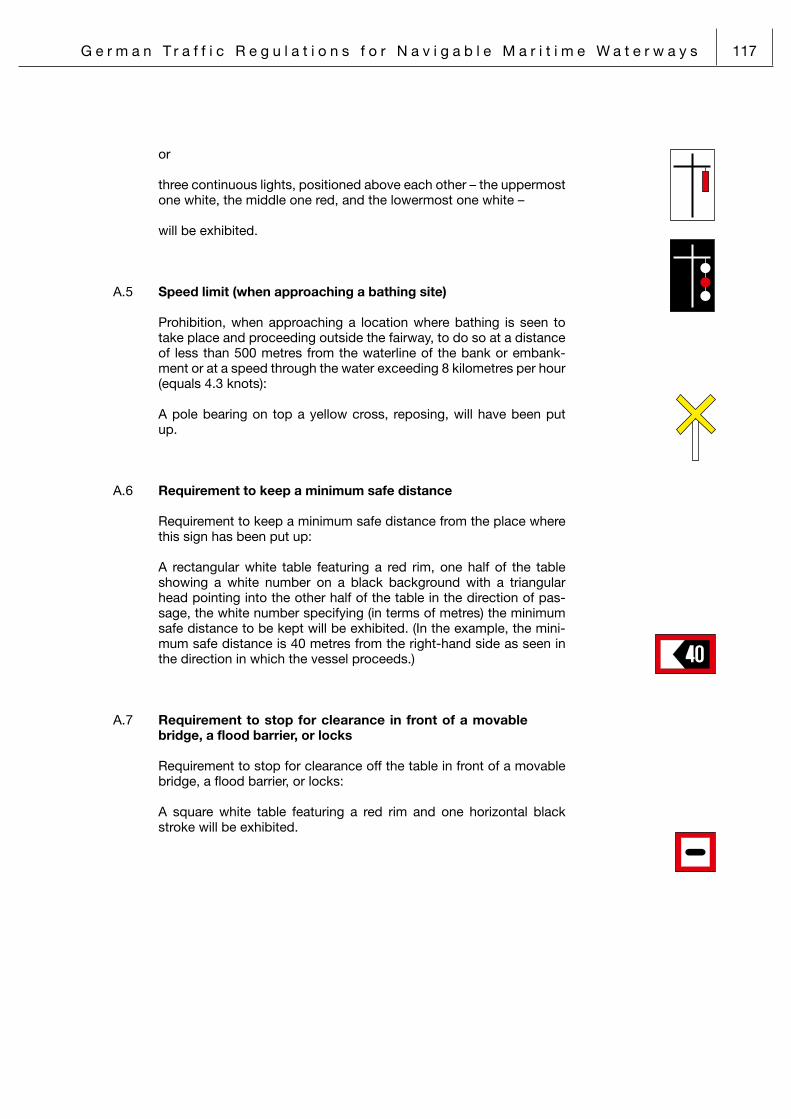
G e r m a n T r a f f i c R e g u l a t i o n s f o r N a v i g a b l e M a r i t i m e W a t e r w a y s 117
or
three continuous lights, positioned above each other – the uppermost one white, the middle one red, and the lowermost one white –
will be exhibited.
A. 5 Speed limit (when approaching a bathing site)
Prohibition, when approaching a location where bathing is seen to take place and proceeding outside the fairway, to do so at a distance of less than 500 metres from the waterline of the bank or embank-ment or at a speed through the water exceeding 8 kilometres per hour (equals 4.3 knots):
A pole bearing on top a yellow cross, reposing, will have been put up.
A. 6 Requirement to keep a minimum safe distance
Requirement to keep a minimum safe distance from the place where this sign has been put up:
A rectangular white table featuring a red rim, one half of the table showing a white number on a black background with a triangular head pointing into the other half of the table in the direction of pas-sage, the white number specifying (in terms of metres) the minimum safe distance to be kept will be exhibited. (In the example, the mini-mum safe distance is 40 metres from the right-hand side as seen in the direction in which the vessel proceeds.)
A. 7 Requirement to stop for clearance in front of a movable bridge, a flood barrier, or locks
Requirement to stop for clearance off the table in front of a movable bridge, a flood barrier, or locks:
A square white table featuring a red rim and one horizontal black stroke will be exhibited.

118 G e r m a n T r a f f i c R e g u l a t i o n s f o r N a v i g a b l e M a r i t i m e W a t e r w a y s
A. 8 Anchoring ban
Prohibition to cast anchor or to club anchors, hawsers, or chains over the ground at a distance of less than 300 metres on either side either of a line connecting the tables or of a line extending a line connecting the upstream pole and the downstream pole bearing the tables on the bank or embankment (Note: In cases where the distances and stretches of waterway as referred to under Item 1(c) of the Preliminary Remarks apply, those values shall apply instead of the 300 metres on either side as referred to in the foregoing):
On both banks or embankments, rectangular white tables featuring a red rim, a red diagonal, and a black anchor symbol pointing upside down will be exhibited
or
on one bank or embankment, a rectangular white table featuring a red rim, a red diagonal, and a black anchor symbol pointing upside down, topped by a white triangular table featuring a red rim, its tip pointing upwards – this being used as the downstream pole – plus, behind this pole, another pole with only a white triangular table featuring a red rim, its tip pointing downwards – this being used as the upstream pole – will have been put up.
A. 9 Mooring ban
Prohibition to moor on the bank or embankment along the stretch of waterway behind the location where the table has been put up:
A square white table featuring a red rim, a red diagonal, and the black symbol of a bollard with a hawser slung around it will be exhibited.
A.10 Lying ban
Prohibition to be lying (either by anchoring or by mooring) along the stretch of waterway behind the sign on the one side of the waterway where the table has been put up:
A square white table featuring a red rim, a red diagonal, and the black capital letter “P” will be exhibited.
A.11 Requirement to proceed in a given direction
Requirement to proceed in the direction indicated by the arrow:
A rectangular white table featuring a red rim and one horizontal black arrow will be exhibited.

G e r m a n T r a f f i c R e g u l a t i o n s f o r N a v i g a b l e M a r i t i m e W a t e r w a y s 119
A.12 Requirement to make a sound signal
Requirement to make the sound signal depicted on the additional table:
A square white table featuring a red rim and a black disc will be ex-hibited.
A.13 Requirement to stop in locks
Requirement to stop close to the lock-wall, in front of the marking, to wait for the exit from the lock-chamber to be cleared:
A vertical yellow stripe will have been painted upon the lock-walls in front of the lock-gates and extending from the water surface up to the lock platform, being continued on the platform for another metre.
A.14 Passage beneath bridge
Prohibition to pass beneath a bridge outside the width limited by the vertical centre-line of the two signs (how-ever, the prohibition does not apply to small vessels in terms of Section 10):
Twin square red-and-white tables reposing on a corner-tip will be exhibited.
A.15 End of stretch of waterway where a requirement or prohibi-tion is effective
A rectangular blue table featuring a white diagonal running from the upper left-hand corner to the lower right-hand corner will be exhib-ited.
A.16 Requirement to stop
Order to stop given by a vessel in the Public Service:
Either a light signal embodying the letter “L”, or the flag signal “L”, both as depicted in the International Code of Signals, will be exhib-ited.

120 G e r m a n T r a f f i c R e g u l a t i o n s f o r N a v i g a b l e M a r i t i m e W a t e r w a y s
A.17 Waters restricted or closed
a) Prohibition for power-driven vessels, jetbikes and surfcraft to proceed
Prohibition for power-driven vessels, jetbikes and surfcraft to navigate on waters that are prohibited for navigation on account of bathing taking place:
Colour: Buoys will be white and will bear a yellow cross, the arms
of which – seen from above – are arranged at right angles to each other;
poles will be white and will bear a broad yellow band.
Shape: Barrel-type buoy, spherical buoy, or pole
Top marks: Narrow lanes open to power-driven vessels, jetbikes and surfcraft may be marked by additional white flags; when at-tached, they will be positioned as top marks.
b) Restricted areas/Closed waters
Prohibition to navigate on the waters closed, with the exception of certain privileged vessels:
Colour: Barrel-type buoys and lightbuoys will be yellow and will bear a red cross, the arms of
which – seen from above – are arranged at right an-gles to each other;
spar buoys and poles will be yellow and will bear a red band.
Shape: Barrel-type buoy, lightbuoy, spar buoy, or pole
Inscription: The word “Sperrgebiet” (German for “prohibited area”) or an abbreviated form, “Sperr-G.”, may be applied in black letters, but on barrel-type buoys and lightbuoys only.
Top marks (if attached): A yellow cross, reposing, may be attached. Spar bu-
oys and lightbuoys will always bear a top mark.
Light (if fitted):
Colour: Yellow
Characteristics: Fl/Blz., Oc (2)/Ubr. (2), or Oc (3)/Ubr. (3)
����������������������
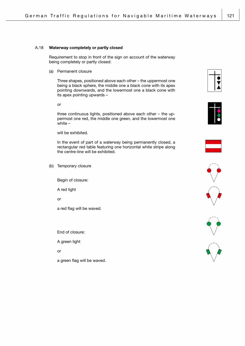
G e r m a n T r a f f i c R e g u l a t i o n s f o r N a v i g a b l e M a r i t i m e W a t e r w a y s 121
A.18 Waterway completely or partly closed
Requirement to stop in front of the sign on account of the waterway being completely or partly closed:
(a) Permanent closure
Three shapes, positioned above each other – the uppermost one being a black sphere, the middle one a black cone with its apex pointing downwards, and the lowermost one a black cone with its apex pointing upwards –
or
three continuous lights, positioned above each other – the up-permost one red, the middle one green, and the lowermost one white –
will be exhibited.
In the event of part of a waterway being permanently closed, a rectangular red table featuring one horizontal white stripe along the centre-line will be exhibited.
(b) Temporary closure
Begin of closure:
A red light
or
a red flag will be waved.
End of closure:
A green light
or
a green flag will be waved.

122 G e r m a n T r a f f i c R e g u l a t i o n s f o r N a v i g a b l e M a r i t i m e W a t e r w a y s
A.19 Passage of movable bridge or flood barrier, entry into/exit from locks, and entry into/exit from the approaches to locks
(Note: As far as the Kiel Canal is concerned, refer-ence should be made to Item A.21 below.)
a) Prohibition to enter or pass (Bridge/flood barrier/locks closed):
Unconditional prohibition to enter or pass: Two continuous red lights, positioned beside each other, will be
exhibited.
Clearance is being prepared: One continuous red light will be exhibited. (Note: In the case of the “Herrenbrücke” Bridge across the River
Trave, this sign means that the bridge may be passed under by any vessel for which it is certain that there is sufficient headroom to do so.)
Installation (bridge/flood barrier/locks) may be entered or passed, as appropriate, by vessels for which it is certain that there is suf-ficient clearance to do so and which observe the right of way under Section 25(5) of traffic flowing in the opposite direction:
One additional continuous white light, positioned above the left-hand red light, will be exhibited.
The lifting mechanism of a lifting bridge is engaged at the first “locked” position and the bridge may be passed under by ves-sels for which it is certain that there is sufficient headroom to do so:
Two additional white lights, positioned above the two red lights, will be exhibited.
b) Clearance for passage/entry (Bridge/flood barrier/locks open. In the case of a lifting bridge,
passage is only permitted by vessels for which it is certain that there is sufficient headroom when the lifting mechanism is en-gaged in the uppermost “locked” position.)
No traffic proceeding in the opposite direction is permitted: Two continuous green lights, positioned beside each other, will
be exhibited.
Traffic proceeding in the opposite direction is permitted, while the right of way under Section 25(5) of traffic flowing in the op-posite direction must be observed:
On additional continous white light, positioned above the left-hand green light will be exhibited.

G e r m a n T r a f f i c R e g u l a t i o n s f o r N a v i g a b l e M a r i t i m e W a t e r w a y s 123
c) Exit from locks
Exit is prohibited: One continuous red light will be exhibited.
Exit is permitted: One continuous green light will be exhibited.
d) Installation is closed to navigation:
Two fixed red lights in a vertical line.
A.20 Entry into the approaches to the Kiel Canal
The regulations set out hereunder do not apply to vessels operated by a shipping police authority, to pilot launches, and to tugs operat-ing with official approval in terms of Item 4 of the second sentence of Section 45:
a) Prohibition to enter
Unconditional prohibition to enter: One interrupted red light will be exhibited.
Clearance is being prepared: One interrupted white light, positioned above one interrupted red
light, will be exhibited.
b) Clearance for entry
Vessels with pilot embarked: One interrupted green light will be exhibited.
Vessels exempted from compulsory pilotage: One interrupted white light, positioned above one interrupted
green light, will be exhibited.
Pleasure craft: One interrupted white light will be exhibited.
A.21 Entry into the by-ports and the locks of the Kiel Canal at Brunsbüttel and Kiel-Holtenau
As far as navigation in the by-ports is concerned, the regulations set out hereunder do not apply to vessels operated by a shipping police authority, to pilot launches, and to tugs operating with official ap-proval in terms of Item 4 of the second sentence of Section 45. The lights described hereunder will be exhibited on the one side of the signal mast that is adjacent to the lock-chamber the entry into which the respective lights control.

124 G e r m a n T r a f f i c R e g u l a t i o n s f o r N a v i g a b l e M a r i t i m e W a t e r w a y s
a) Prohibition to enter Unconditional prohibition to enter: One interrupted red light will be exhibited.
Clearance is being prepared: One interrupted white light, positioned above one interrupted red
light, will be exhibited.
b) Clearance for entry for vessels with pilot embarked
Vessel must make fast to the centre wall: One interrupted green light will be exhibited.
Vessel must make fast to a side wall: One interrupted white light, positioned beside one interrupted
green light, will be exhibited. (The white light will be exhibited on the side where the wall lies.)
c) Clearance for entry for vessels exempted from compulsory pilot-age
Vessel must make fast to the centre wall: One interrupted white light, positioned above one interrupted
green light, will be exhibited.
Vessel must make fast to a side wall: Two interrupted white lights – one positioned be-side, and one
positioned above, one interrupted green light – will be exhibited. (The white light beside the green light will be exhibited on the
side where the wall lies.)
d) Pleasure craft: One interrupted white light will be exhibited.
A.22 Passage through a siding (along the Kiel Canal)
a) Entry into the siding (Lights will be exhibited on the siding entrance signal mast.)
Entry is prohibited: One quick-flashing red light will be exhibited.
Entry:
Entry may be expected to be permitted: One interrupted green light will be exhibited.
Entry must be expected to be denied to one or more vessel categories: One interrupted white light will be exhibited.

G e r m a n T r a f f i c R e g u l a t i o n s f o r N a v i g a b l e M a r i t i m e W a t e r w a y s 125
b) Exit from the siding (Lights will be exhibited on the siding exit signal mast; lights to
address vessels of categories 1 and 2, provided that they will proceed at a speed of less than 15 kilometres per hour (corre-sponding to about 8.5 knots) as well as lights permitting exit to one or more vessel categories will be exhibited either on their own or in addition to the other lights; in the latter case, they will be positioned beside such other lights.)
Exit is prohibited (ie, the limit of the siding must not be crossed)
Exit is prohibited for vessels of categories 1 and 2 provided that they will proceed at a speed of less than 15 kilometres per hour:
Two white isometric lights, positioned above each other, will be exhibited.
Exit is prohibited for vessels of categories 2 and above: Three interrupted lights, positioned above each other – the up-
permost and lowermost ones red, the middle one white – will be exhibited.
Exit is prohibited for vessels of categories 3 and above: One interrupted red light will be exhibited.
Exit is prohibited for vessels of categories 4 and above: Two interrupted red lights, positioned above each other, will be
exhibited.
Exit is prohibited for vessels of categories 5 and above: Three interrupted lights, positioned above each other – the up-
permost two red, the lowermost one white – will be exhibited.
Exit prohibited for vessels of category 6: Three interrupted lights, positioned above each other – the up-
permost red, the two lowermost ones white – will be exhibited.
Exit is prohibited for composite units being towed: One interrupted red light, positioned above one interrupted white
light, will be exhibited.
Exit is prohibited for all vessels: Three interrupted red lights, positioned above each other, will be
exhibited.

126 G e r m a n T r a f f i c R e g u l a t i o n s f o r N a v i g a b l e M a r i t i m e W a t e r w a y s
Exit will shortly be permitted for one or more vessel categories: One white isometric light will be exhibited.
Exit is permitted for all vessels: One interrupted green light will be exhibited.
A.23 Traffic at the Brunsbüttel Oil Terminal
a) Exit into the Kiel Canal from the turning basin off the Oil Termi-nal
Exit is prohibited
Exit is prohibited for all vessels: Two continuous red lights, positioned beside each other, will be
exhibited.
Exit is permitted for vessels other than tug-assisted ones, pro-vided that the right of way of traffic on the Kiel Canal will be ob-served:
Two continuous red lights, positioned beside each other, and one continuous white light, positioned above the left-hand red light, will be exhibited.
Exit is permitted: Two continuous green lights, positioned beside each other, will
be exhibited.
b) Traffic on the Kiel Canal near the turning basin
Proceeding is prohibited: Two continuous red lights, positioned beside each other, will be
exhibited. Proceeding is permitted
Proceeding is permitted without restrictions: Two continuous green lights, positioned beside each other, will
be exhibited.
Proceeding is permitted, while traffic approaching from the turn-ing basin must be expected:
Two continuous green lights, positioned beside each other, and one continuous white light, positioned above the left-hand green light, will be exhibited.
A.24 Entry into, and exit from, the Gieselaukanal and the Dead Trave Arm (ie, the old course of the River Trave at the “Teer-hofinsel” Islet)
a) Entry and exit are prohibited: One continuous red light will be exhibited.
b) Entry and exit are permitted: No particular visual sign will be exhibited.

G e r m a n T r a f f i c R e g u l a t i o n s f o r N a v i g a b l e M a r i t i m e W a t e r w a y s 127
A.25 Entry into the Husumer Au
Entry is prohibited: One continuous red light will be exhibited.
A.26 Entry into the approaches of the Eider Flood Barrier
Entry is prohibited: One quick-flashing red light will be exhibited.
B. Warnings and advice
B.1 Ferry crossing
a) Crossing of a ferry not maintaining connecting lines with one or both banks respectively embankments
A rectangular blue table featuring the white symbol of a ferry will be exhibited.
b) Crossing of a ferry maintaining connecting lines with one or both banks respectively embankments
A rectangular blue table featuring the white symbol of a ferry with a horizontal white band underneath will be exhibited.
B.2 Passage of solid-built bridge
a) Passage permitted in both directions: One square yellow table, reposing on a corner-tip,
will be exhibited.
b) Passage permitted in one direction (while closed to traffic flowing in the opposite direction):
Two square yellow tables, reposing on a corner-tip, will be exhibited.
B.3 Telephone
A square blue table featuring the white symbol of a telephone hand-set will be exhibited.

128 G e r m a n T r a f f i c R e g u l a t i o n s f o r N a v i g a b l e M a r i t i m e W a t e r w a y s
B.4 Limit of a siding (along the Kiel Canal) (Section 2(1) Item 18(c) of these Traffic Regulations is relevant.)
A square white table featuring a black rim will be exhibited. (Note: The Western part of the siding at Audorf-Rade is limited, to the North, by the buoy 2/Obereider 1.)
B.5 Water-skiing (Section 31(1)(first sentence) of these Traffic Regulations is relevant.)
Waters within a fairway where water-skiing is permitted: A rectangular blue table featuring the white symbol of a water-skier
will be exhibited.
B.6 Extraordinary obstacle to navigation
By night, three continuous lights will be exhibited – the uppermost two red, the
lowermost one green.
By day, two black spheres, positioned above one black cone – its apex point-
ing downwards – will be exhibited.
B.7 Transverse current
Dangerous transverse currents must be expected to occur: Two continuous white light panels, positioned beside each other, will
be exhibited.
B.8 Jetbikes (Section 31(5)(first sentence) of these Traffic Regulations is relevant.)
Waters within a fairway where jetbiking is permitted: A rectangular blue table featuring the white symbol of a person riding
a jetbike will be exhibited.
B.9 Wind-surfing boards (Section 31(1)(first sentence) of these Traffic Regulations is relevant.)
Water within a fairway where wind-surfing is permitted: A rectangular blue table featuring the white symbol of a windsurfer
will be exhibited.

G e r m a n T r a f f i c R e g u l a t i o n s f o r N a v i g a b l e M a r i t i m e W a t e r w a y s 129
B.10 Access to a fairway/to the centre-line of a shipping route
Signs marking the access to fairways for inward-bound ships/the centre-line of shipping routes (where these are not identifi-able by reference to a lightship, a large automated navigational buoy, a beacon or racon, a jetty, or the like):
Colour: Red and white vertical stripes
Shape: Spherical buoy, lightbuoy, spar buoy, or pole (in this case, possibly without any colour)
Inscription: Serial numbering will be applied, with or with-out the name of the fairway, which may be shortened.
Top marks (if attached): A red sphere may be attached. Spar buoys
andlightbuoys will always bear a top mark.
Light (if fitted):
Colour: White
Characteristics: Iso/Glt. or Oc/Ubr.
B.11 Fairway limits (lateral marks)
a) Starboard side of the fairway:
Colour: Green
Shape: Pointed buoy, lightbuoy, or pole (in this case, possibly without any colour)
Inscription (if applied): Serial numbering (odd numbers only, the se-
ries starting at the seaward end of the fairway marking or as specifically determined) may be applied, with or without a small letter immedi-ately following, and with or without the name of the fairway, which may be shortened.
Top marks (if attached): A green cone – its apex pointing upwards – or
a broom – its tip pointing downwards – may be attached. Poles will always bear a top mark.
Light (if fitted):
Colour: Green
Characteristics: Fl/Blz., Fl (2)/Blz. (2), Oc (2)/Ubr. (2), Oc (3)/Ubr. (3), Q/Fkl., IQ/Fkl. unt. or Iso/Glt.

130 G e r m a n T r a f f i c R e g u l a t i o n s f o r N a v i g a b l e M a r i t i m e W a t e r w a y s
b) Port side of the fairway:
Colour: Red
Shape: Flat-top buoy, lightbuoy, spar buoy, pole (in this case, possibly without any colour), or prick (in this case, always without any colour)
Inscription (if applied): Serial numbering (even numbers only, the se-
ries starting at the seaward end of the fairway marking or as specifically determined) may be applied, with or without a small letter immedi-ately following, and with or without the name of the fairway, which may be shortened.
Top marks (if attached): A red cylinder or a broom – its tip pointing up-
wards – may be attached. Poles will always bear a top mark.
Light (if fitted):
Colour: Red
Characteristics: Fl/Blz., Fl (2)/Blz. (2), Oc (2)/Ubr. (2), Oc (3)/Ubr. (3), Q/Fkl., IQ/Fkl. unt. or Iso/Glt.
B.12 (This Item has been suspended.)

G e r m a n T r a f f i c R e g u l a t i o n s f o r N a v i g a b l e M a r i t i m e W a t e r w a y s 131
B.13 Fairway branching off from, or joining, another fairway
a) Starboard side of the through fairway/Port side of the fair-way branching off or joining:
Colour: Green, with a horizontal red band
Shape: Pointed buoy, lightbuoy, or pole
Inscription (if applied): Beneath the serial (odd) numbering of the lat-
eral fairway marking, and separated therefrom by a horizontal stroke, the name, which may be shortened, and the first serial number of the fairway branching off, respectively, the last serial number of the fairway joining, may be ap-plied.
Top marks (if attached): A green cone – its apex pointing upwards – or
a broom – its tip pointing downwards – may be attached.
Light (if fitted):
Colour: Green
Characteristics: Fl (2+1)/Blz. (2+1)
b) Port side of the through fairway/Starboard side of the fair-way branching off or joining:
Colour: Red, with a horizontal green band
Shape: Flat-top buoy, lightbuoy, spar buoy, or pole
Inscription (if applied): Beneath the serial (even) numbering of the lat-
eral fairway marking, and separated therefrom by a horizontal stroke, the name, which may be shortened, and the first serial number of the fairway branching off, respectively, the last serial number of the fairway joining, may be applied.
Top marks: A red cylinder or a broom – its tip pointing up-wards – will be attached.
Light (if fitted):
Colour: Red
Characteristics: Fl (2+1)/Blz. (2+1)

132 G e r m a n T r a f f i c R e g u l a t i o n s f o r N a v i g a b l e M a r i t i m e W a t e r w a y s
Positions on the starboard side of the through fairway/star-board side of the fair-way branching off or joining, respec-tively, on the port side of the through fair-way/port side of the fairway branching off or joining may be marked by lateral marks as described and depicted under Item B.11 above. When this is done, inscrip-tions as described in the foregoing will be applied and top marks will be attached.
Fairways branching off or joining may alternatively be marked by cardinal marks as described and depicted un-der Item B.15 below, with the inscriptions as described in the foregoing applied.
B.14 Roadstead (Section 2(1)(Item 3) of these Traffic Regulations is relevant.)
a) Roadstead in general:
Colour: Yellow
Shape: Barrel-type buoy or light-buoy
Inscription: The (full or shortened) name of the roadstead, which may be followed by a number, will be applied in black letters.
Top marks (if attached): A yellow cross, reposing, may be attached.
Light (if fitted):
Colour: Yellow
Characteristics: Fl/Blz., Oc (2)/Ubr. (2), or Oc (3)/Ubr. (3)
Where a roadstead borders to the star-board or the port side of a fair-way, the relevant side of the roadstead will be marked by the respective lateral fairway mark (Item B.11 above) which will bear – in addition to the fairway mark and separated from it by a horizontal stroke above – the full or shortened name of the roadstead and possibly a number.

G e r m a n T r a f f i c R e g u l a t i o n s f o r N a v i g a b l e M a r i t i m e W a t e r w a y s 133
b) Roadstead for vessels carrying certain dangerous goods:
Colour: Yellow
Shape: Barrel-type buoy
Inscription: A black capital letter “P” will be applied, with or without a number immediately following.
Top marks (if attached): A yellow cross, reposing, may be attached.
c) Roadstead for vessels put under quarantine:
Colour: Yellow
Shape: Barrel-type buoy
Inscription: A black capital letter “Q” will be applied, with or without a number immediately following.
Top marks (if attached): A yellow cross, reposing, may be attached.

134 G e r m a n T r a f f i c R e g u l a t i o n s f o r N a v i g a b l e M a r i t i m e W a t e r w a y s
B.15 Danger spot
“General danger spots” include shallow waters, wreck sites, natural or man-made underwater structures, and all other sorts of obstacles to navigation. As a rule, such general danger spot will be marked by one or more cardinal marks; these indicate the situation of the quadrant they mark in relation to the danger spot proper.
���
�

G e r m a n T r a f f i c R e g u l a t i o n s f o r N a v i g a b l e M a r i t i m e W a t e r w a y s 135
a) North cardinal mark:
Colour: Black above yellow
Shape: Lightbuoy, beacon-type buoy, spar buoy, or pole
Inscription (if applied): The full or shortened name of the danger spot
to which it refers, with or without a compass direction added, may be applied.
Top marks: Two black cones, positioned above each oth-er, their apices pointing upwards, will be ex-hibited.
Light (if fitted):
Colour: White
Characteristics: VQ/SFkl. or Q/Fkl.
b) East cardinal mark:
Colour: Black, with a broad horizontal yellow band
Shape: Lightbuoy, beacon-type buoy, spar buoy, or pole
Inscription (if applied): The full or shortened name of the danger spot
to which it refers, with or without a compass direction added, may be applied.
Top marks: Two black cones, positioned above each oth-er, their apices pointing away from each other, will be exhibited.
Light (if fitted):
Colour: White
Characteristics: VQ (3)/SFkl. (3) or Q (3)/Fkl. (3)

136 G e r m a n T r a f f i c R e g u l a t i o n s f o r N a v i g a b l e M a r i t i m e W a t e r w a y s
c) South cardinal mark:
Colour: Yellow above black
Shape: Lightbuoy, beacon-type buoy, spar buoy, or pole
Inscription (if applied): The full or shortened name of the danger spot
to which it refers, with or without a compass direction added, may be applied.
Top marks: Two black cones, positioned above each oth-er, their apices pointing downwards,
will be exhibited.
Light (if fitted):
Colour: White
Characteristics: VQ (6) + LFl (6)/SFkl. (6) + Blk. Q(6) + LFl (6)/Fkl. (6) + Blk.
d) West cardinal mark:
Colour: Yellow, with a broad horizontal black band
Shape: Lightbuoy, beacon-type buoy, spar buoy, or pole
Inscription (if applied): The full or shortened name of the danger spot
to which it refers, with or without a compass direction added,
may be applied.
Top marks: Two black cones, positioned above each oth-er, their apices pointing towards each other, will be exhibited.
Light (if fitted):
Colour: White
Characteristics: VQ (9)/SFkl. (9) or Q(9)/Fkl. (9)

G e r m a n T r a f f i c R e g u l a t i o n s f o r N a v i g a b l e M a r i t i m e W a t e r w a y s 137
e) Isolated danger spot:
Colour: Black, with a broad horizontal red band
Shape: Lightbuoy, beacon-type buoy, spar buoy, or pole
Inscription (if applied): The name of the danger spot may be ap-
plied.
Top marks: Two black cones, positioned above each oth-er, will be exhibited.
Light (if fitted):
Colour: White
Characteristics: Fl (2)/Blz. (2)
f) Recent danger spot:
Recent danger spots will be marked ei-ther like general danger spots or like isolated danger spots; however, to take account of the particular circumstances prevailing at recent danger spots, at least one of the visual signs will be doubled-up and may be fitted with a racon featuring the letter “D” as response signal.
B.16 Specific area or location
The concrete meaning of the visual sign may be gathered from charts or other nautical publications, or it may be deducted from its inscription.
Colour: Yellow
Shape: The sign may take any shape, but will prefer-ably be a barrel-type buoy, a lightbuoy, a spar buoy, or a pole.
Inscription (if applied): The concrete meaning of the visual sign may
be spelt out by an inscription in black letters.
Top marks: A yellow cross, reposing, may be attached.
Light (if fitted):
Colour: Yellow
Characteristics: Fl/Blz., Oc (2)/Ubr. (2), or Oc (3)/Ubr. (3) – in the case described under (g) below, only Fl (5)/Blz. (5)
138 G e r m a n T r a f f i c R e g u l a t i o n s f o r N a v i g a b l e M a r i t i m e W a t e r w a y s
A number of examples are given here-under:
a) Warning of a “danger area”:
This type of sign will designate the limits of an area where a warning is given not to enter let alone navigate therein, for example, because of a military exercise, marine scien-tific research and/or survey work, or hydrographic or simi-lar activities taking place there.
Inscription: The inscription “Warn-Gebiet” or “Warn-G.” (German equivalent for “Warning! Danger area!”) will be applied.
In cases where specific visual signs as may be introduced by virtue of specific statutory regulations, may temporarily turn a “danger area” into a “restricted area”, barrel-type buoys, lightbuoys, spar buoys, and poles will bear a yellow cross, reposing, as top mark.
b) Warning of a “danger spot”:
This type of sign will designate a spot where a warning is given not to come close let alone cross it (for example, because it is being used for military, marine scientific re-search and/or survey purposes, for hydrographic or oce-anographic and similar activities, or because equipment related to any one or more of these purposes or activities is located there).
Inscription: The inscription “Warn-stelle” or “Warn-St.” (German equivalent for “Warning! Danger spot!”) will be applied.
c) Fishing grounds:
This type of sign will designate the limits of fishing grounds, protected hatching grounds, shellfish nurseries, and/or the approaches thereto.
Inscription: The inscription “Fischerei” or “Fisch” (German equivalent for “fish-(ery)”) will be applied.
Top marks: A yellow shape in the form of a fish will be exhibited.
d) Dumping ground for dredged spoils:
This type of sign will designate the limits of an area where dredged spoils will be dumped.
Inscription: The inscription “Schüttstelle” or “Schütt-St.” (German for “dumping ground”) will be ap-plied.

G e r m a n T r a f f i c R e g u l a t i o n s f o r N a v i g a b l e M a r i t i m e W a t e r w a y s 139
e) Cables and pipelines:
This type of sign will designate the course of cables and pipelines.
Inscription: The inscription “Kabel”, “K”, “Pipeline”, or “Pipe” (German for “cable(s)”, respectively, “pipeline”) will be applied.
f) Measured mile:
This type of sign will designate a meas-ured mile.
Inscription: The inscription “Meile” (German for “mile”) will be applied.
g) Oceanographic data acquisition station:
This type of sign will designate a floating device or instal-lation used for the
acquisition of oceanographic data.
Inscription: The inscription “ODAS” (the acronym for “Oceanographic Data Ac-quisition Station”) will be applied.
Characteristics: Fl (5)/Blz. (5)
B.17 Mooring buoy
This will be a buoy to which a vessel may be moored
Colour: Yellow
Shape: Barrel-type buoy, Cylinder buoy, or a buoy in any other form.
Inscription: The word “Festmachen” (German equivalent for “mooring”) or an abbreviate form, “Festm.”, will be applied in black letters.

140 G e r m a n T r a f f i c R e g u l a t i o n s f o r N a v i g a b l e M a r i t i m e W a t e r w a y s
Section II – Sound signals
C.1 Stop!
(This is an order given by a vessel in the Public Service.)
One short blast, followed by one prolonged blast, followed by two short blasts, will be sounded.
C.2 Prohibition to pass/enter
(Bridge, flood barrier, or locks can temporarily not be opened.)
Four short blasts will be sounded.
C.3 Permission to pass/enter
(Bridge/flood barrier/locks open. In the case of a lifting bridge, passage is only permitted by vessels for which it is certain that there is sufficient headroom when the lifting mechanism is en-gaged in the uppermost “locked” position.)
a) To address outbound vessels, two prolonged blasts, followed by one short blast, fol-
lowed by one prolonged blast, will be sounded.
b) To address inbound vessels, two prolonged blasts, followed by two short blasts, fol-
lowed by one prolonged blast, will be sounded.
C.4 Waterway closed
Two groups of three prolonged blasts each will be sounded.

G e r m a n T r a f f i c R e g u l a t i o n s f o r N a v i g a b l e M a r i t i m e W a t e r w a y s 141
C.5 Entry from sea into the approaches to, or the locks of, the Kiel Canal
a) Brunsbüttel (“Neue Schleuse” Locks):
A tone of three seconds’ duration, which is repeated after a pause of seven seconds, will be sounded.
b) Kiel-Holtenau (“Neue Schleuse” Locks):
Sound signal directing a vessel to enter the starboard lock-chamber:
A tone of three seconds’ duration, which is repeated after a pause of seven seconds, will be sounded.
Sound signal directing a vessel to enter the port side lock-chamber:
Groups of two tones each of two seconds’ duration, with a one-second interruption between the two tones, which are repeated after a pause of five seconds, will be sounded.
C.6 Entry into the locks of the Kiel Canal from within the Canal
a) Brunsbüttel (“Neue Schleuse” Locks):
Sound signal directing a vessel to enter the starboard lock-chamber:
A continuous sequence of single strokes of the bell will be sounded.
Sound signal directing a vessel to enter the port side lock-chamber:
Double strokes of the bell, with intervals of four seconds in between, will be sounded.
b) Kiel-Holtenau (“Neue Schleuse” Locks):
Sound signal directing a vessel to enter the starboard lock-chamber:
A sequence of single strokes of the bell, with intervals of three seconds in be-tween, will be sounded.
Sound signal directing a vessel to enter the port side lock-chamber:
Double strokes of the bell, with intervals of three seconds in between, will be sounded.

142 G e r m a n T r a f f i c R e g u l a t i o n s f o r N a v i g a b l e M a r i t i m e W a t e r w a y s
Annex II
Visual signs and sound signals of vessels
II.1 Visual signs of vessels
II.2 Sound signals of vessels
Explanatory notes relating to Annex II
1 General
Section 6(1) of the Traffic Regulations for Navigable Waterways provides that vessels may, in addition to the visual signs and sound signals prescribed under the provisions of the Interna-tional Regulations for Preventing Collisions at Sea, 1972, as amended, only exhibit the visual signs and make the sound signals as provided for in the present Annex.
2 General note relating to lights
The lights prescribed under the provisions of the International Regulations for Preventing Colli-sions at Sea, 1972, are depicted hereunder in addition to the lights prescribed under the provi-sions of the present Annex.
2.1 Note relating to the characteristics of lights
Where a quick light is prescribed, the repetition rate of “quick flashes” shall not be less than 120 light phenomena per minute.
2.2 Depiction of lights
all-round light in the colour specified
fixed light in the colour specified, visible over a limited arc of the ho-rizon
fixed light in the colour specified, visible over a limited arc of the ho-rizon, into a direction away from the observer’s stand-point
quick light in the colour specified, visible over the entire horizon

G e r m a n T r a f f i c R e g u l a t i o n s f o r N a v i g a b l e M a r i t i m e W a t e r w a y s 143
isophase light in the colour specified, visible over the entire horizon
light in the colour specified, being moved in a vertical line, and visible over the entire horizon
shell throwing stars in the colour specified
3. Note relating to sound signals
Depiction of sound signals
One prolonged blast
One short blast
Stroke of the bell
Rapid ringing of the bell

144 G e r m a n T r a f f i c R e g u l a t i o n s f o r N a v i g a b l e M a r i t i m e W a t e r w a y s
II.1 Visual signs of vessels
1 Sign to identify a vessel in the Public Service engaged on a shipping police mission
(Section 7 of these Traffic Regulations is relevant.)
A vessel in the Public Service, when engaged on a shipping police mission and, thereby, endangering the safety and easy flow of traffic,
shall exhibit a continuous blue quick light.
The same applies to vessels of the German Society for the Rescue of Shipwrecked Sailors when carrying out a rescue operation.
2 Sign to identify a vessel of the Federal Customs Administ-ration
A vessel of the Federal Customs Administration,
by night: shall exhibit three all-round green lights, positioned above each
other in a vertical line;
by day: shall fly a square green flag at any suitable location.
3 Sign to identify a vessel of the Federal Armed Forces or of the Federal Border Guard, or a power-driven vessel towing firing-range targets
A vessel of the Federal Armed Forces or of the Federal Bor-der Guard or a power-driven vessel towing firing-range targets, which another vessel is approaching by night in a hazardous manner and from which an adequate distance must be kept;
shall fire shells throwing white stars.
4 [This Item has been suspended.]

G e r m a n T r a f f i c R e g u l a t i o n s f o r N a v i g a b l e M a r i t i m e W a t e r w a y s 145
5 Sign to identify a ferry crossing a river or canal (Section 2(1)(Item 12) of these Traffic Regulations is rel-
evant.)
5.1 Ferry underway and maintaining connecting lines with one or both banks respectively embankments
A ferry maintaining connecting lines with one or both banks respectively embankments, by night,
shall exhibit one all-round green light, positioned above one all-round white light.
5.2 Ferry underway on the Kiel Canal, the River Trave, or the River Warnow and not maintaining connecting lines with one or both banks respectively embankments
A ferry underway on the Kiel Canal, the River Trave, or the River Warnow and not maintaining connecting lines with one or both banks respectively embankments, by night,
shall exhibit one yellow isophase light on the masthead plus one yellow isophase light on either side both afore and astern, each corner light being visible only when looking at it away from the vessel.
6 Sign to identify a vessel or composite unit carrying certain dangerous goods in terms of Section 2(1)(Item 16) of these Traffic Regulations or an empty vessel in terms of Section 30(1)(Item 3) thereof
(on the Kiel Canal also vessels within the description of particulary dangerous vessels and composite units)
A vessel or composite unit carrying “certain dangerous goods” in terms of Section 2(1)(Item 16) of these Traffic Regulations or an empty vessel in terms of Section 30(1)(Item) thereof,
by night: shall exhibit one all-round red light;
by day: shall fly the flag “B” as depicted in the International Code of
Signals.
A vessel falling within the description above, when navigating on the Kiel Canal, shall exhibit the said visual signs on her port-side yard-arm or at some other suitable location on her port- side so as to be easily perceivable from afore.
The said visual signs shall also be exhibited when the vessel in question lies at anchor or has moored.
Warships are exempted from the obligation to observe this regulation.

146 G e r m a n T r a f f i c R e g u l a t i o n s f o r N a v i g a b l e M a r i t i m e W a t e r w a y s
7. [This Item has been suspended.]
8. [This Item has been suspended.]
9. Sign to identify floating apparel used by a vessel engaged in dredging or underwater operations
On floating apparel used by a vessel engaged in dredging or underwater operations, the following visual signs shall be ex-hibited, viz
by night: one all-round white light;
by day: a square red table.
10. Sign to identify a vessel restricted in her ability to mao-euvre and engaged in dredging or underwater operations in a fairway
A vessel restricted in her ability to manoeuvre and engaged in dredging or underwater operations in a fairway, when no ob-struction is being caused on any side of the vessel, shall exhibit the following visual signs in addition to the visual signs pre-scribed under the provisions of Rule 27(b) of the International Regulations for Preventing Collisions at Sea, 1972, viz
by night: two all-round green lights, positioned above each other in a
vertical line;
by day two diamond shapes, positioned above each other in a vertical
line.

G e r m a n T r a f f i c R e g u l a t i o n s f o r N a v i g a b l e M a r i t i m e W a t e r w a y s 147
11 Sign to identify a moored vessel, a floating installation in terms of Section 2(1)(Item 5) of these Traffic Regulations, or an extraordinary floating object in terms of Section 2(1)(Item 6) thereof
11.1 The length of the vessel is less than 50 metres.
Such vessel shall exhibit, by night,
one all-round white light, positioned amidships on the side next to the fairway, respectively, at the end closest to the fairway, and preferably at deck level.
11.2 The length of the vessel is 50 metres or more.
Such vessel shall exhibit, by night,
one all-round white light each afore and astern on the side of hers nearest to the fairway channel and preferably at deck lev-el.
11.3 Exceptions and Special Regulations
With the exception of a vessel moored along the Kiel Canal, a moored vessel need not exhibit any visual signs when the out-line of the vessel is permanently visible and sufficiently well lit by any other source of light or when the vessel is lying in way of a mooring site the outline of which is sufficiently well and permanently visible.
The same applies to floating installations and to extraordinary floating objects. Pleasure craft lying at a dedicated mooring site along the Kiel Canal need not exhibit any lights.
Where two or more vessels are moored alongside each other, only the vessel lying nearest to the fairway channel need ex-hibit the visual signs described above. The same applies to extraordinary floating objects.
A vessel lying in a siding of the Kiel Canal for any reason other than on account of the prevailing traffic or weather conditions shall exhibit the visual signs described above; in the case of a composite unit being towed, each of the vessels forming the unit shall exhibit the visual signs.
11.4 Vessels, mooried at a mooring buoy according to Annex I, B17
Those vessels have to show visula signals according to Rule 30 COLREGs.

148 G e r m a n T r a f f i c R e g u l a t i o n s f o r N a v i g a b l e M a r i t i m e W a t e r w a y s
12 Sign to identify a vessel navigating on the Kiel Canal with a pilot embarked (Section 2(1)(Item 18a) and wishing to leave the locks for the Canal
Visual signs shall be exhibited prior to leaving the locks for the Canal passage.
12.1 Vessel categories 1 and 2
A vessel of category 1 or 2, by day, shall fly the flag “H” as depicted in the International Code of
Signals.
12.2 Vessel category 3
No specific visual sign is prescribed for vessels of category 3.
12.3 Vessel category 4
A vessel of category 4, by night, shall exhibit one all-round green light.
A vessel of category 4, by day, shall exhibit one black cylinder.
12.4 Vessel category 5
A vessel of category 5, by night, shall exhibit two all-round green lights, positioned above each other in a vertical line.
A vessel of category 5, by day, shall exhibit one black cylinder, positioned above one black sphere.

G e r m a n T r a f f i c R e g u l a t i o n s f o r N a v i g a b l e M a r i t i m e W a t e r w a y s 149
12.5 Vessel category 6
A vessel of category 6, by night, shall exhibit two all-round green lights, positioned above each other in a vertical line.
A vessel of category 6, by day, shall exhibit one black sphere, positioned above one black cylinder.
Note: For vessels of categories 4 to 6, the visual signs prescribed shall be exhibited on their starboard yard-arm or at some other suitable location on their starboard side as to be easily perceiv-able from afore.
13 Sign to identify a vessel exempted from compulsory pilo-tage on the Kiel Canal in terms of Section 2(1) (Item 15) of these Traffic Regulations
Visual signs shall be exhibited prior to entering the locks for the Canal passage.
13.1 Vessels of category 1
A vessel of category 1, by night, shall exhibit one all-round yel-low light, positioned not less than 1.50 metres in a vertical line below the fore masthead light.
A vessel of category 1, by day, shall fly the flag “N” as depicted in the International Code of Signals.

150 G e r m a n T r a f f i c R e g u l a t i o n s f o r N a v i g a b l e M a r i t i m e W a t e r w a y s
13.2 Vessels of category 2
A vessel of category 2, by night, shall exhibit one all-round yel-low light, positioned not less than 1.50 metres in a vertical line below the fore masthead light.
A vessel of category 2, by day, shall fly the flag “N” as depicted in the International Code of Signals above the pennant “2” as depicted in the International Code of Signals.
13.3 Vessels of category 3
A vessel of category 3, by night, shall exhibit one all-round yel-low light, positioned not less than 1.50 metres in a vertical line below the fore masthead light.
A vessel of category 3, by day, shall fly the flag “N” as depicted in the International Code of Signals above the pennant “3” as depicted in the International Code of Signals.
13.4 Vessels of category 4
A vessel of category 4, by night, shall exhibit one all-round yellow light, positioned not less than
1.50 metres in a vertical line below the fore masthead light, plus one all-round green light.
A vessel of category 4, by day, shall fly the flag “N” as depicted in the International Code of Signals above the pennant “4” as depicted in the International Code of Signals, and shall in addi-tion exhibit one black cylinder.
Note: For vessels of category 4, the visual signs prescribed shall be exhibited on their starboard yard-arm or at some other suitable location on their starboard side so as to be easily perceivable from afore.

G e r m a n T r a f f i c R e g u l a t i o n s f o r N a v i g a b l e M a r i t i m e W a t e r w a y s 151
14 Sign to identify a vessel stuck on the embankment of the Kiel Canal
A vessel stuck on the embankment of the Kiel Canal, by night, shall exhibit one all-round white light on the side of hers where
passage is permitted and on the part of hers nearest to the fairway channel.
15 Sign to identify a vessel wishing to embark a sea pilot
15.1 A vessel requesting a sea pilot from the seaward pilot sta-tion of one of the sea pilotage districts for pilotage in the respective district, or from the roads off Bremerhaven for pilotage to the seaward position of the pilot launch or for pilotage to one of the ports situated in, and owned and operated by, the Free Hanseatic City of Bremen proper, or from the roads off Brunsbüttel for pilotage to the seaward position of the pilot launch or into Hamburg.
By Day shall fly the flag “G” as depicted in the International Code of Signals.
15.2 A vessel requesting a sea pilot from the pilot vessel in the approach to Rivers Jade and Weser for pilotage into Wil-helmshaven, or from the roads off Bremerhaven for pilo-tage to one of the Lower Saxony ports in the Weser Estu-ary, or from the roads off Brunsbüttel or Kiel-Holtenau for pilotage on the Kiel Canal.
By Day shall fly the flag “G” as depicted in the International Code of Signals above the pennant “1” as depicted in the In-ternational Code of Signals.
16 Sign to identify a vessel wishing to disembark a sea pilot
A vessel wishing to disembark a sea pilot, by day, shall fly the flag “G” as depicted in the International Code of Signals at half-mast.

152 G e r m a n T r a f f i c R e g u l a t i o n s f o r N a v i g a b l e M a r i t i m e W a t e r w a y s
II.2 Sound signals of vessels
1 Beware!
The sound signal described hereunder shall be given whenever and wherever the traffic situation requires a “Beware!” signal to be sounded. Such situations shall be deemed to exist, in particular,
in a general way: when entering another fairway channel, a port or harbour, or when leaving a port or harbour, locks, a mooring site, or anchoring grounds;
on the Kiel Canal: when approaching floating apparel or a loca-tion marked by a visual sign as described under Item A.4 of An-nex I, as well as when leaving the Projensdorf bunkering station and wishing to proceed westwards.
A power-driven vessel towing firing-range targets shall give the appropriate sound signal when another vessel is approaching by night in a threatening manner.
1.1 On all navigable waterways except for the Kiel Canal,
vessels shall sound one prolonged blast.
1.2 On the Kiel Canal,
1.2.1 a vessel proceeding westwards shall sound one prolonged blast;
1.2.2 a vessel proceeding eastwards shall sound two prolonged blasts.
2 Danger! Warning!
2.1 General danger and warning signal
Where a vessel is putting another vessel to danger or is put to danger herself by another vessel, she shall give the following signal:
one prolonged blast followed by four short blasts followed by another one prolonged blast followed by another
four short blasts.

G e r m a n T r a f f i c R e g u l a t i o n s f o r N a v i g a b l e M a r i t i m e W a t e r w a y s 153
2.2 Stay away!
Where certain dangerous goods in terms of Section 2(1)(Item 16) of these Traffic Regulations or radioactive materials are car-ried aboard a vessel or composite unit and are actually being released or threaten to be released, or where there is risk of explosion, the following sound signal shall be given for as long as the traffic situation so requires:
one short blast followed by a prolonged blast.
This signal shall be given at least five times a minute, with inter-vals of 2 seconds each in be-tween. In the event that appropri-ate installations are provided on board, the signal characteris-tics shall also be given as a visual signal, use being made of an all-round white light for this purpose.
Where the situation described above occurs at a mooring site or a cargo-handling terminal, the signal shall also be given by the person responsible for the operation of such site or termi-nal.
The provisions of Annex III of the International Regulations for Preventing Collisions at Sea, 1972, shall apply, mutatis mutandis, to the sound-signalling equipment provided at car-go-handling terminals.
2.3 Warning signal to mean “am reducing my speed” (signal for use on the Kiel Canal)
Where a vessel is reducing her speed while another vessel is approaching her, she shall in good time give the following sound signal:
one prolonged blast followed by three short blasts followed by another one prolonged blast followed by another
three short blasts.
2.4 Warning signal to mean “have the intention of mooring” (si-gnal for use on the Kiel Canal)
Where a vessel is about to moor in a port or at a cargo-handling terminal while another vessel is approaching her, she shall in good time give the following sound signal:
one prolonged blast followed by three short blasts.

154 G e r m a n T r a f f i c R e g u l a t i o n s f o r N a v i g a b l e M a r i t i m e W a t e r w a y s
3 Sound signals to be used in restricted visibility
3.1 On the Kiel Canal, a vessel other than a ferry, when under-way, shall give the following sound signal when approa-ching a location marked by the visual sign described under Item B.1 (Annex I):
3.1.1 a vessel proceeding westwards shall sound one prolonged blast;
3.1.2 a vessel proceeding eastwards shall sound two prolonged blasts.
Otherwise, the appropriate sound signal shall be given when circumstances so require.
3.2 Power-driven vessel underway and being towed or pushed
In derogation of the provisions of Rule 35(a) respectively 35(b) of the International Regulations for Preventing Collisions at Sea, 1972, a power-driven vessel underway and being towed or pushed shall give the following sound signal at intervals of not more than two mi-nutes:
one prolonged blast followed by one short blast followed by two prolonged blasts.
The tug or tugs towing or pushing such vessel shall not give the sound signal under Rule 35(c) of the International Regulations for Preventing Collisions at Sea, 1972.
3.3 Ferry crossing a river or canal
3.3.1 A ferry maintaining connecting lines with one or both banks re-spectively embankments shall give the following sound signal throughout her crossing:
a continuous sequence of single strokes of the bell.
3.3.2 A ferry not maintaining connecting lines with one or both banks respectively embankments shall give the following sound sig-nal throughout her crossing:
one short blast followed by two prolonged blasts.

G e r m a n T r a f f i c R e g u l a t i o n s f o r N a v i g a b l e M a r i t i m e W a t e r w a y s 155
4 [This Item has been suspended.]
5 Give way! (Section 24(3) of these Traffic Regulations is relevant.)
5.1 Signal to mean “I wish to give way by shearing to my port side”
(on the Kiel Canal also answering signal of an approaching vessel):
one prolonged blast followed by two groups of two short blasts each.
5.2 (This Item has been suspended.)
6 Request signal to mean “Open bridge/flood barrier/locks”
6.1 On all navigable waterways, except for the River Trave, the following signal shall be given to request a bridge/flood barrier/locks to be opened (in the case of a lifting bridge with more than one “locked” positions, to mean “Open as far up as until the lifting mechanism is engaged at the first “locked” position”):
two prolonged blasts.
6.2 On the River Trave, the following signal shall be given to request a bridge/flood bar-rier/locks to be opened:
6.2.1 To address outbound vessels, two prolonged blasts will be sounded.
6.2.2 To address inbound vessels, two groups of two prolonged blasts each will be sounded.
6.3 In the case of a lifting bridge with more than one “locked” positions, the following signal shall be given to mean “Open as far up as until the lifting mechanism is engaged at the uppermost “locked” position”):
two prolonged blasts followed by one short blast.

156 G e r m a n T r a f f i c R e g u l a t i o n s f o r N a v i g a b l e M a r i t i m e W a t e r w a y s
7 Towing signals
7.1 Signal to mean “I request tug assistance”:
One short blast followed by one prolonged blast, which is followed by another short blast followed by another prolonged blast, will be sounded.
7.2 Manœuvring signals given during towing operations
7.2.1 Signal to mean, as appropriate, “Bow tug take towing line” or “Bow tug start towing” or “Bow tug let go”:
one prolonged blast followed by two short blasts followed by one prolonged blast.
7.2.2 Signal to mean, as appropriate, “Stern tug take towing line” or “Stern tug start towing” or “Stern tug let go”:
one prolonged blast followed by two short blasts followed by two prolonged blasts.
7.2.3 Signal to mean “Bow tug tow to starboard”: one short blast.
7.2.4 Signal to mean “Bow tug tow to port”: two short blasts.
7.2.5 Signal to mean “Stern tug tow astern”: three short blasts.
7.2.6 Signal to mean “Stern tug tow to starboard”: three short blasts followed, after a pause, by another short
blast.
7.2.7 Signal to mean “Stern tug tow to port”: three short blasts followed, after a pause, by another two short
blasts.
7.2.8 Signal to mean, as appropriate, “Slow down manoeuvre” or “Stop manoeuvre”:
one prolonged blast.
7.2.9 Signal to mean “Danger!”: five or more short blasts.
8. [This Item has been suspended.]

G e r m a n T r a f f i c R e g u l a t i o n s f o r N a v i g a b l e M a r i t i m e W a t e r w a y s 157