gis, supporting efficient asset management on industrial ...€¦ · 2014 esri southeast user...
TRANSCRIPT

GIS, supporting efficient asset management on industrial plants
Ruben Busink – Royal Haskoning DHV Head Geo Information Management Department
Eric Straalman – Geocom Informatik AG Head of International Sales

Challenges Industrial Asset Management

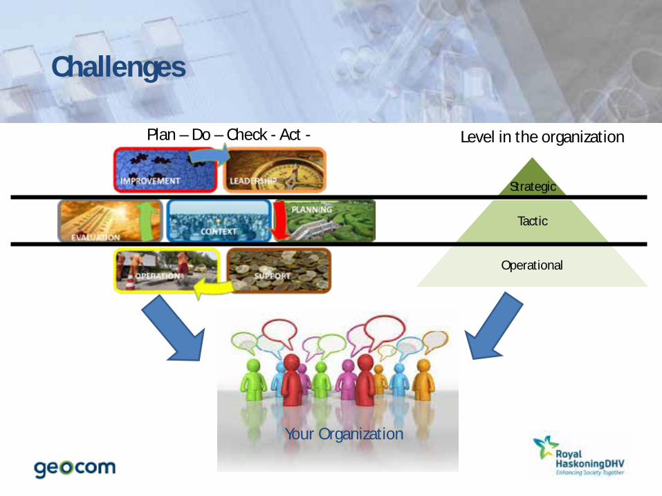
Strategic
Tactical
Operational
Challenges
Strategic
Tactic
Operational
Your Organization
Level in the organization
Challenges
Plan – Do – Check - Act -

Challenges
Keep Track on Changes Multiple Independent Construction Activities
Comply with law and regulations Increasing Demands Regarding Burden of Proof
Aging Workforce Retirement: 50% in 10 Years, Loss of Expertise
Aging Infrastructure & Installations Purposive Maintenance
Last but not least: Being cost effective
Information Management Secure, Accurate, Timely Sharing information

Challenges
Information Management What is where and how? GIS is complementary to CAD - CAD shows the ‘technical what’ in detail - GIS adds where and how everything is
spatially related, including the functional spatial analytics & calculations

Challenges
Information Management Integration GIS allows the integration with other business systems, enabling site managers to analyze and make timely decisions.
Integration Spatial Analysis
GIS brings specialized spatial
information to everyone

Challenges
Information Management Disparate Data: - Analogue paper based maps - Database / excel storage of administrative data - File based CAD Drawings)
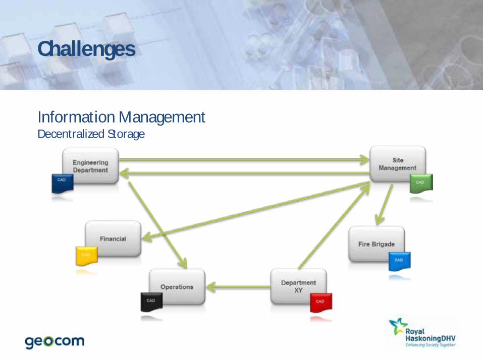
Challenges
Information Management Decentralized Storage
Challenges
This all leads to: - Un-Secure Access to Information
- Discrepancy between Map and Reality
- Related information in multiple systems with different “owners”
- Synchronization of Information

Who are we?


Technology platform
Solution Framework
Domain Expertise

And this is what we offer…

Castor, GIS Based Asset Management Powered by GEONIS / ArcGIS

ASSET MANAGEMENT
Assets touch our daily lives

Costs
Risks Performances
Asset Management Finding optimal balance
Risk based asset management, based on ISO 55000
Needs the right information, - on the right time - In the right place - In the right scale - On the right device
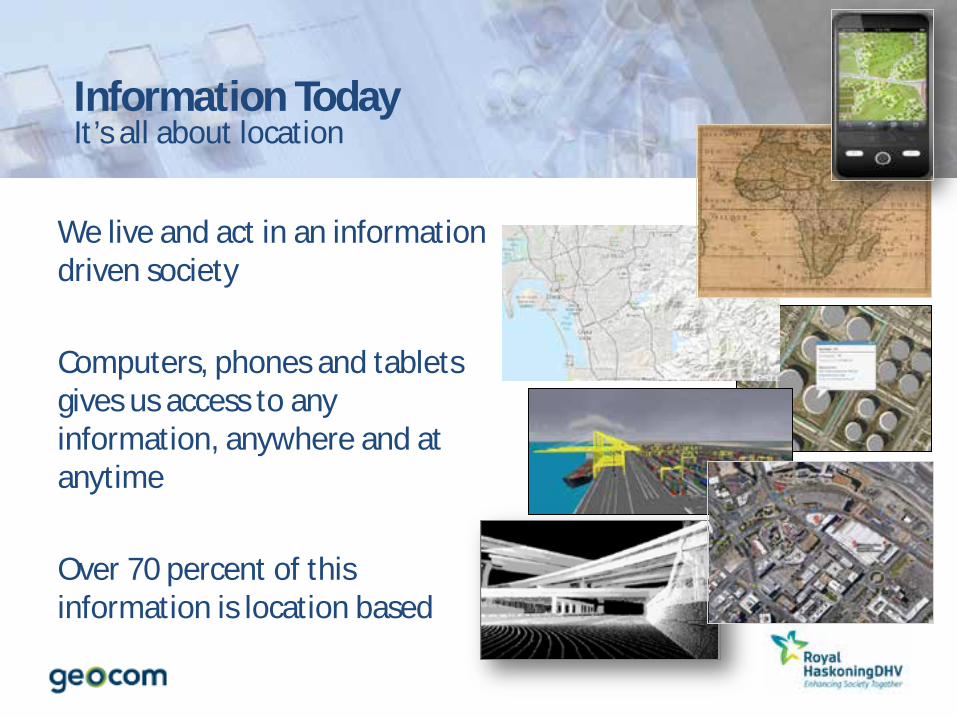
It’s all about location
We live and act in an information driven society Computers, phones and tablets gives us access to any information, anywhere and at anytime Over 70 percent of this information is location based
Information Today

The coordinate of an asset represents – Position – Size – Spatial impact – Interspatial relationships with other assets
Adding the spatial component:
– Opens your world – Adds value – Makes you more efficient
…and the same goes for our assets

A geo-based approach for Asset Management The Essence
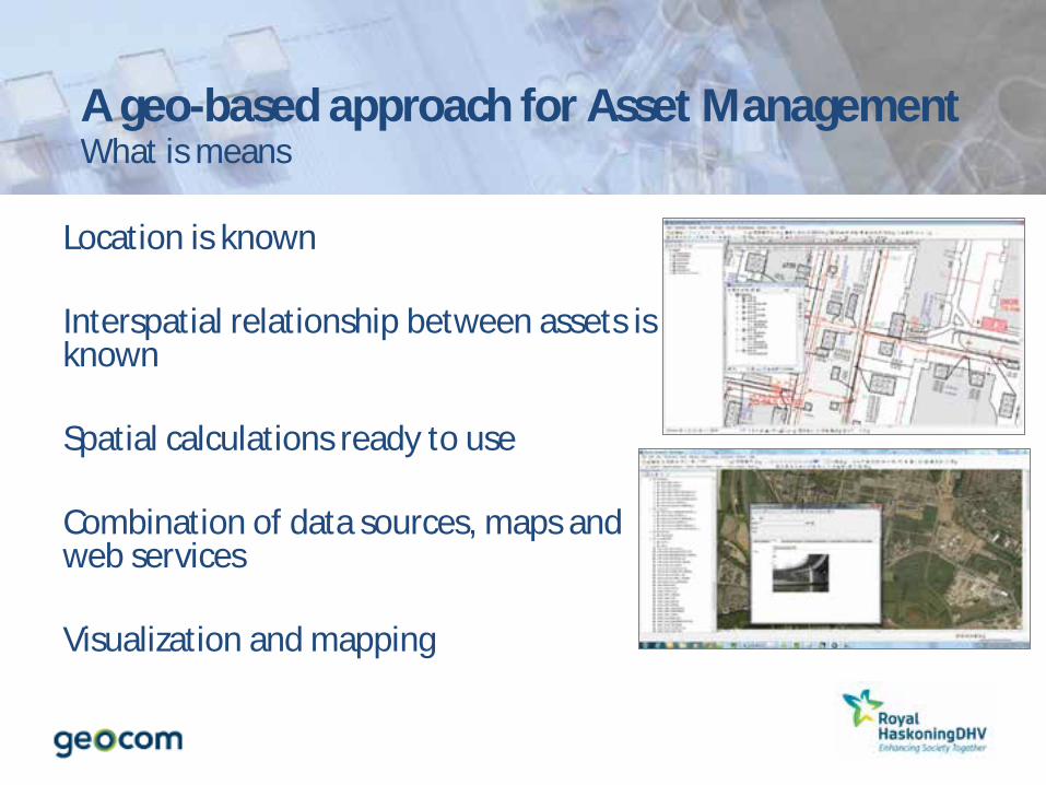
Location is known Interspatial relationship between assets is known Spatial calculations ready to use Combination of data sources, maps and web services Visualization and mapping
A geo-based approach for Asset Management What is means
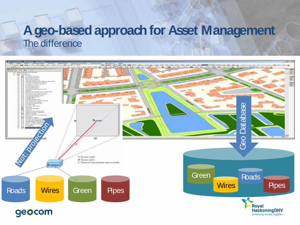
Roads Wires Green Pipes Pipes
Green Wires
Roads
A geo-based approach for Asset Management The difference
Geo
Data
base

Risk based Asset Management the geographical way
€ / $
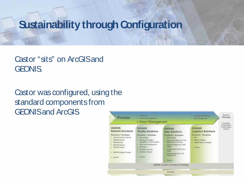
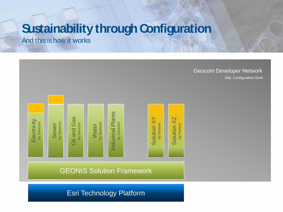
Sustainability through Configuration
Castor “sits” on ArcGIS and GEONIS. Castor was configured, using the standard components from GEONIS and ArcGIS
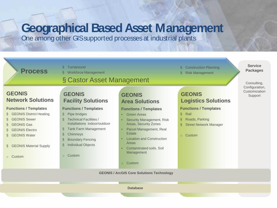
Geographical Based Asset Management
Service Packages
Consulting, Configuration, Customization
Support
Functions / Templates § GEONIS District Heating § GEONIS Sewer § GEONIS Gas § GEONIS Electro § GEONIS Water
§ GEONIS Material Supply o Custom
Functions / Templates § Pipe bridges § Technical Facilities /
Installations indoor/outdoor § Tank Farm Management § Chimneys § Boundary Fencing § Individual Objects
o Custom
Functions / Templates • Green Areas • Security Management, Risk
Areas, Security Zones • Parcel Management, Real
Estate • Location and Construction
Areas • Contaminated soils. Soil
Management
o Custom
Functions / Templates § Rail § Roads, Parking § Street Network Manager o Custom
GEONIS Network Solutions
GEONIS Facility Solutions
GEONIS Area Solutions
GEONIS Logistics Solutions
Database
GEONIS / ArcGIS Core Solutions Technology
Process § Construction Planning § Risk Management
§ Turnaround § Workforce Management
§ Castor Asset Management
One among other GIS supported processes at industrial plants
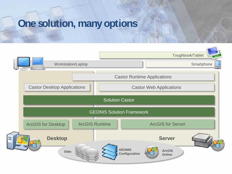
One solution, many options
Server Desktop
ArcGIS for Desktop ArcGIS for Server ArcGIS Runtime
GEONIS Solution Framework
Solution Castor
Data GEONIS Configuration
ArcGIS Online
Toughbook/Tablet
Smartphone Workstation/Laptop
Castor Desktop Applications Castor Web Applications
Castor Runtime Applications
GEONIS Solution Framework
Esri Technology Platform
Ele
ctric
ity
by G
eoco
m
Sew
er
by G
eoco
m
Oil
and
Gas
by
Geo
com
Wat
er
by G
eoco
m
Indu
stria
l Pla
nts
by G
eoco
m
Sol
utio
n X
Z by
Par
tner
Sol
utio
n X
Y by
Par
tner
Geocom Developer Network XML Configuration Shell
Sustainability through Configuration And this is how it works

GEONIS Solution Framework
Esri Technology Platform
Ele
ctric
ity
by G
eoco
m
Sew
er
by G
eoco
m
Oil
and
Gas
by
Geo
com
Wat
er
by G
eoco
m
Indu
stria
l Pla
nts
by G
eoco
m
Sol
utio
n X
Z by
Par
tner
Sol
utio
n X
Y by
Par
tner
Geocom Developer Network
GDN Studio
XML Configuration Shell
GDN Knowledge Base
Sustainability through Configuration And this is how it works

GEONIS Solution Framework
Solution Version X
by Geocom
Solution Version X+1
by Geocom Sustainable GEONIS Overloading Mechanism
Sustainability through Configuration And this is how it works
And this is what we cover… 3 User Cases examples Site Construction / Maintenance Incident Management Site Navigation

Example Chemelot (NL) 195 km sewerage 80 km roads & 20 parking lots 200 hectare landscaping on site 500 hectare landscaping off site 3 contractor shed parks 16 bridges and structures 40 km column racks 1 harbor 80 km rail
Site Construction / Maintenance

Spatial Search Query
Site Construction / Maintenance

© Geocom – eine Firma der Esri Unternehmensgruppe 34
We need to build a new Installation. How does this fit to the excising infrastructure?
Site Construction / Maintenance

Custom form per asset
Including the datamodel
Linking objects and information
Controlled update conditions
Scalable, Configurable
Site Construction / Maintenance

© Geocom – eine Firma der Esri Unternehmensgruppe 36
Is there a free space on pipe bridges?
Including safety & connectivity information
Site Construction / Maintenance

© Geocom – eine Firma der Esri Unternehmensgruppe 37
How are the relations?
Reality
Borders
Land use
Munition Clearance
Networks
Site Construction / Maintenance

Environmental issues (subsurface) ?
Site Construction / Maintenance

© Geocom – eine Firma der Esri Unternehmensgruppe 39
Integration Analysis
GIS brings specialized
information to everyone
GIS helps to understand the
physical relation of the surroundings
Site Construction / Maintenance

Incident Management
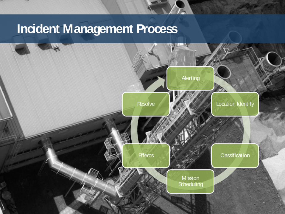
Incident Management Process
Alerting
Location Identify
Classification
Mission Scheduling
Effects
Resolve

© Picture: Chemical Process Safety (CCPS)
It’s a location based problem
Fast acting is key!
© Center for Chemical Process Safety

Castor is a location intelligence application
Monitoring service Location Identification Classification
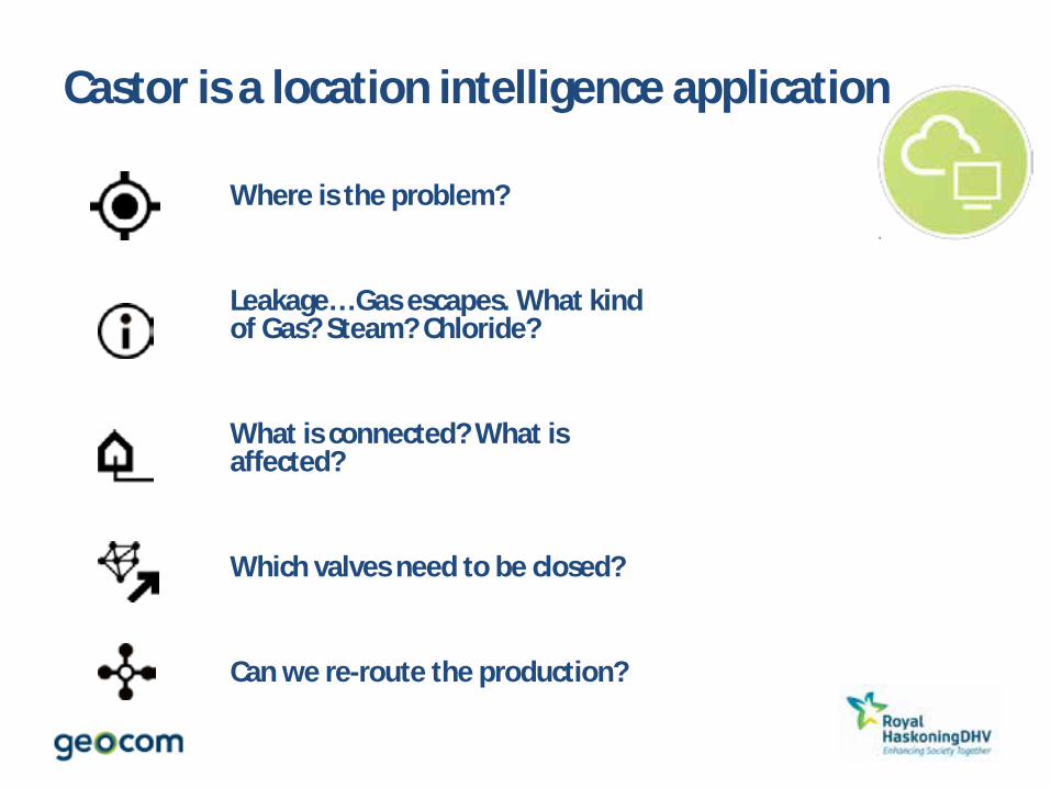
Castor is a location intelligence application
Where is the problem?
Leakage… Gas escapes. What kind of Gas? Steam? Chloride?
What is connected? What is affected?
Which valves need to be closed?
Can we re-route the production?

Resolve
• Improve coordination of activities • Timely and accurate decision making • Fast resolving
© AP Photo/Brennan Linsley

© Geocom – eine Firma der Esri Unternehmensgruppe 46
Site Navigation
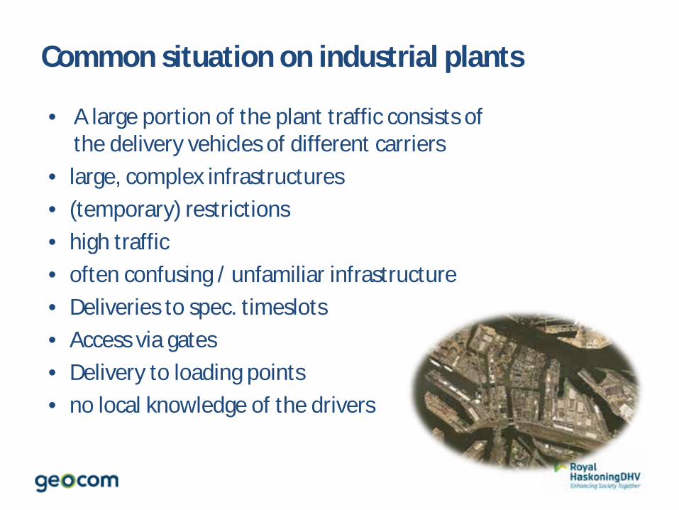
Common situation on industrial plants
• A large portion of the plant traffic consists of the delivery vehicles of different carriers
• large, complex infrastructures • (temporary) restrictions • high traffic • often confusing / unfamiliar infrastructure • Deliveries to spec. timeslots • Access via gates • Delivery to loading points • no local knowledge of the drivers

Actors Involved in Plant Navigation
Different stakeholders are involved in the processes and procedures of the plant navigation
site management plant protection
plant Logistics
Plant traffic
freight forwarders
plant navigation
© Geocom – eine Firma der Esri Unternehmensgruppe 49
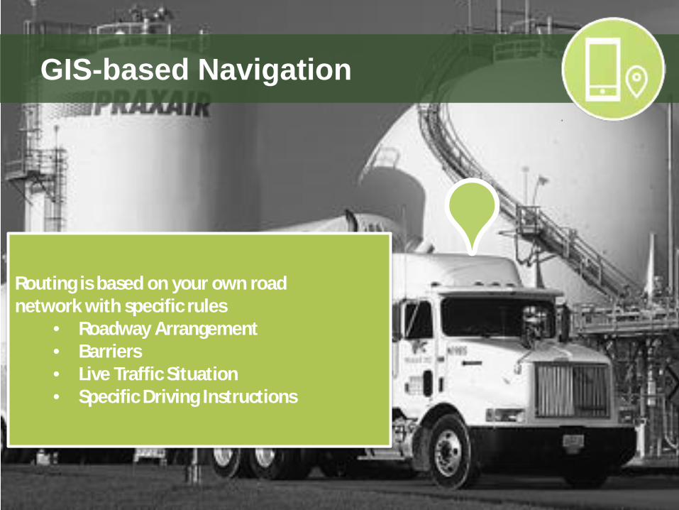
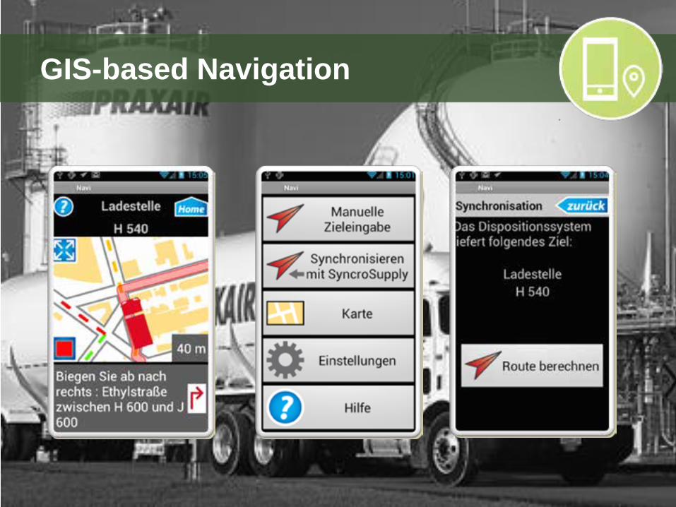
GIS-based Navigation
Routing is based on your own road network with specific rules
• Roadway Arrangement • Barriers • Live Traffic Situation • Specific Driving Instructions
© Geocom – eine Firma der Esri Unternehmensgruppe 50
GIS-based Navigation

© Geocom – eine Firma der Esri Unternehmensgruppe 51
What we support
• Add the plant infrastructure to e.g. Navteq Data
• Support the delivery traffic with navigation • Safe bypass of restrictions and obstacles • Smooth delivery traffic • Traffic control and monitoring • Avoid traffic backlog on factory premises
and parking areas • Increase the utilization of the loading points • Risk reduction by minimizing the time on
the site

References

…and many more
References
Summarizing
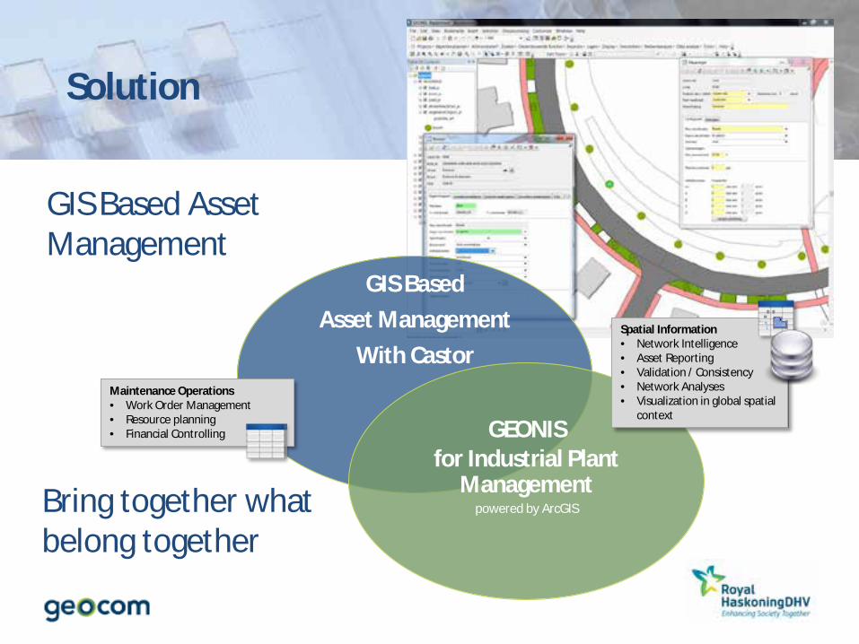
Solution
GIS Based Asset Management
With Castor
GEONIS for Industrial Plant
Management powered by ArcGIS
Maintenance Operations • Work Order Management • Resource planning • Financial Controlling
Spatial Information • Network Intelligence • Asset Reporting • Validation / Consistency • Network Analyses • Visualization in global spatial
context
GIS Based Asset Management
Bring together what belong together

Solution
GIS based Asset Management enables Site Managers: • To improve coordination of activities • Making timely and accurate decisions • Stream Line maintenance activities – set the right focus • Keep the information systems in sync with each other and with reality • Make the data available throughout the Esri Technology Platform
See the Big Picture Lower the Cost of Ownership

Thank you for attending!