gnss vulnerability issues in korea - unoosa · gnss vulnerability issues in korea may 14, 2013 ......
TRANSCRIPT

GNSS Vulnerability Issues in Korea
May 14, 2013
Sang Jeong Lee
National GNSS Research Center
Chungnam National University

National GNSS Research Center, CNU May 14. 2013.
Contents
GPS jamming in Korea
GoK policy
GBAS deployment plan
JLOC as a National Agenda Program
2

National GNSS Research Center, CNU May 14. 2013.
GNSS Vulnerability
Critical issue especially for infrastructure, e.g. airport, wireless communications network
GPS jamming in Korea
GPS disruptions for the past three years due to North Korean jamming(reported by the Central Radio Management Office of South Korea)
GPS Jamming in Korea
3
Dates
Aug 23–26,
2010
(4 days)
Mar 4–14,
2011
(11 days)
Apr 28 – May 13, 2012
(16 days)
Jammer
locations Kaesong
Kaesong, Mountain Kumgang
Kaesong
Affected
areas Gimpo, Paju,
etc. Gimpo, Paju,
Gangwon, etc. Gimpo, Paju,
etc.
GPS
disruptions
181 cell
towers,
15 airplanes,
1 battle ship
145 cell
towers,
106 airplanes,
10 ships
1,016 airplanes,
254 ships
Jammer 50~100Km area
jamming (Maximum
400Km)
Effected the communication
and some of military
equipment South Korea
North Korea
GaeSeong
Seoul Incheon
International Airport
GPS jamming
HaeJu

National GNSS Research Center, CNU May 14. 2013.
4
GNSS vulnerability issues in civil applications
GBAS deployment plans
Widely deployed wireless communications network
Governmental policy
International cooperation
• ICAO, ITU
Development of countermeasures
• Field manuals in case of jamming
• Jammer location technology
GoK Policy

National GNSS Research Center, CNU May 14. 2013.
International Cooperation
ITU(2012.05.11) the problem about ‘whether the North Korea jamming violate
or obey the international regulation’
ICAO(2012.07.05) Expressed serious concern about North Korea's GPS jamming
and urged to prevent recurrence of similar incidents
ITU and ICAO will conduct joint research about the impact of GPS jamming in the international civil aviation
Notice the decision of the board of directors for all 191 ICAO member states

National GNSS Research Center, CNU May 14. 2013.
National Countermeasures
Ministry of Security and Public Administration (2012.12, 2013.02)
prepare the field manual in case of GPS jamming
Korea Communications Commission (2013.02.18)
operate the warning system and GPS emergency response team
Development of Countermeasure for Safety of Life application
GBAS Development plans (2010~2014)
JLOC as National Agenda Program (2010~2015)
• To protect integrity, ground facilities must quickly detect the presence of any hazardous interference falling within the restricted band used by GNSS
• To protect availability, ground personnel must be able to quickly locate and deactivate the interference source

National GNSS Research Center, CNU May 14. 2013.
* MOA : Military Operating Area
Issues and Needs in Korea
Amount of the Air traffic increases 5% per year in Korea
Mountainous terrain over 70%, Airspace & Route are restricted due to MOA
Difficult to implement two-way ILS service in some airports
Demand for new green technologies for the aircraft operation
7
GBAS Deployment Plans

National GNSS Research Center, CNU May 14. 2013.
GBAS Operational Technology Development
Purpose
Establish the GBAS Approval Process for Korea
Build up the National Research Infrastructure and the GBAS Demo. Airport
Develop the Research Capability for GBAS Technology
Schedule
2010. 10. ~ 2014. 8. (3 Years and 11 Months)
Supported by MLTM (Ministry of Land, Transport and Maritime
Affairs)
Scope
Establish the FAA Certified System at the GBAS Demonstration Airport
Develop the T&E Equipment and System for Approval Activities; SDA, FA, OA
Build up the Government Approval Process and TDP
Establish the Korean Ionosphere Threat Model
Improve the Integrity S/W with Field Data Verification
GBAS CAT-I Operational Technology Development Program
National GNSS Research Center, CNU May 14. 2013.
GBAS Operational Technology Development
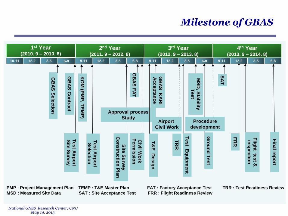
Milestone of GBAS
4th Year (2013. 9 – 2014. 8)
3rd Year (2012. 9 – 2013. 8)
2nd Year (2011. 9 – 2012. 8)
KO
M (P
MP
, TE
MP
)
GB
AS
Co
ntra
ct
Site
Su
rve
y
Co
ns
tructio
n P
lan
Tes
t Airp
ort
Se
lec
tion
GB
AS
KA
RI
Ac
ce
pta
nce
Airport
Civil Work
9-11 12-2 3-5 6-8 9-11 12-2 3-5 6-8 9-11 12-2 3-5 6-8 10-11 12-2 3-5 6-8
MS
D, S
tab
ility
Tes
t
Civ
il Wo
rk
Pe
rmis
sio
n
SA
T
Procedure
development
GB
AS
Se
lec
tion
Fin
al re
po
rt
FR
R
TR
R
GB
AS
FA
T
Tes
t Airp
ort
Site
Su
rve
y
Tes
t Eq
uip
me
nt
Gro
un
d T
es
t
Flig
ht te
st &
ins
pec
tion
PMP : Project Management Plan TEMP : T&E Master Plan FAT : Factory Acceptance Test TRR : Test Readiness Review
MSD : Measured Site Data SAT : Site Acceptance Test FRR : Flight Readiness Review
Approval process
Study
T&
E D
es
ign
1st Year (2010. 9 – 2010. 8)

National GNSS Research Center, CNU May 14. 2013.
Finished Site Survey/Site selection and started civil work for installing
GBAS Ground system at Gimpo Airport.
Developed Test Equipment and decided Testing/Inspection
Requirements for Ground/Flight testing and inspection of GBAS
Designed GBAS Flight Procedure(ILS-like) for GLS
GBAS Ground system will be installed into Gimpo Airport by the 2nd
Quarter of this year.
Summary

National GNSS Research Center, CNU May 14. 2013.
11
Funded by Korea Research Council of Fundamental Science Technology in 2010~2015
Development of Jammer location technologies for GBAS operation
Jammer Location Technology as a National Agenda Program

National GNSS Research Center, CNU May 14. 2013.
12
System configuration for field test .
Control Station
Jamming Signal
Monitoring Station
HTTP
Wireless Network
TCP/IP,
HTTP
IF Snapshot
Sampling Data
(4xTDOA, 2xAOA) Jammer
Location
result
Data Collection
TDOA, AOA
Algorithm
Wireless Network
Google Map
Jamming Signal Receiving Station
Jammer Location
Algorithm
Antenna
Power supply
RF/IF signal processor
Time synchronization processor
Monitor
Server, algorithm processor
IF data storage
Jamming Signal
Receiver (TDOA,AOA)
Jamming Signal
Receiver (TDOA,AOA)
Jamming Signal
Receiver (TDOA)
Jamming Signal
Receiver (TDOA)
Control Station H/W
Receiving Station H/W CW, DSSS Jamming Signal

National GNSS Research Center, CNU May 14. 2013.
13
Antenna
TDOA Antenna
AOA Antenna
TDOA Data Receiver
AOA Data Receiver
REF/Time Syn. Supply
Controller
Power Supply
Data trans. SW
Sever/HDD
Data receive S/W
Web Server
PC
Google Map
Hardware
Software
Novatel
5 element array antenna
AOA/TDOA Data Receiver
REF Clock/Time Sync.
Power Supply
Novatel, DL V3 Receiver
National GNSS Research Center, CNU May 14. 2013.
14
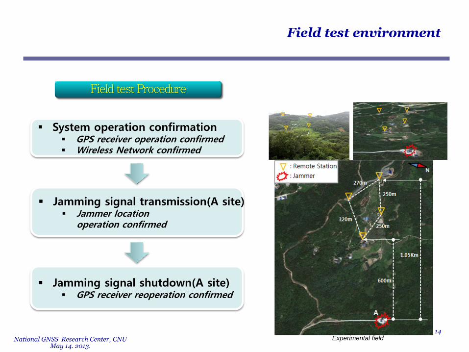
Field test environment.
System operation confirmation GPS receiver operation confirmed Wireless Network confirmed
Jamming signal transmission(A site) Jammer location
operation confirmed
Jamming signal shutdown(A site) GPS receiver reoperation confirmed
Experimental field

National GNSS Research Center, CNU May 14. 2013.
Location : a radio test site of a national research center
15
2ed signal receiving station
1st signal receiving station
Reference station(for TDOA)
3rd signal receiving station
4th signal receiving station
Experimental environment
Control Station
Field test environment

National GNSS Research Center, CNU May 14. 2013.
Field test results.
TDOA algorithm
0 50 100 150 200 250 3001.075
1.08
1.085
1.09
1.095
1.1
1.105
1.11
1.115
1.12x 10
7 correlation function(Rcv1-Rcv1), peak = 151
Sample
Corr
ela
tion v
alu
e
0 50 100 150 200 250 3001.454
1.456
1.458
1.46
1.462
1.464
1.466
1.468x 10
7 correlation function(Rcv1-Rcv2), peak = 191
Sample
Corr
ela
tion v
alu
e
0 50 100 150 200 250 3001.15
1.155
1.16
1.165
1.17
1.175x 10
7 correlation function(Rcv1-Rcv3), peak = 38
Sample
Corr
ela
tion v
alu
e
0 50 100 150 200 250 3001.075
1.08
1.085
1.09x 10
7 correlation function(Rcv1-Rcv4), peak = 97
Sample
Corr
ela
tion v
alu
e
Correlation result
0 20 40 60 80 100 120 140 160198
200
202
204
206
208
210
212
214
216
218TDOA measurement(Rcv1-Rcv4), var = 3.2477
time[s]
TD
OA
measure
ment
0 20 40 60 80 100 120 140 160
450
452
454
456
458
460
462
464
466
468
TDOA measurement(Rcv1-Rcv3), var = 3.4968
time[s]
TD
OA
measure
ment
0 20 40 60 80 100 120 140 160
-132
-130
-128
-126
-124
-122
-120
-118
-116
-114
TDOA measurement(Rcv1-Rcv2), var = 7.3011
time[s]
TD
OA
measure
ment
TDOA measurement
Reference
station
2ed signal
receiving station
3rd signal
receiving station
4th signal
receiving station
TDOA meas. 1
TDOA meas. 2
TDOA meas. 3
10m
Variance = 7.3m
Variance = 3.5m
Variance = 3.3m
10m
10m
16 600 650 700 750 800
150
200
250
300
350
NE plot, varN = 72.1007 var
E = 968.9204
East
Nort
h
TDOA measurement
True position
150m
50m
CEP = 23.9m

National GNSS Research Center, CNU May 14. 2013.
AOA algorithm
17
1st signal
receiving station
2ed signal
receiving station
AOA measurement
Field test results.
Improvement is being
done

National GNSS Research Center, CNU May 14. 2013.
Future work
18
modification
(Multi, Dynamic
Jammer)
Implementation
at Airport
Jammer
Location
test bed
Operation
Improvement of AOA technique
Considering dynamic jammer using FDOA,
TDOA/FDOA algorithm
Considering multiple jammers
Other jammer type
CW, DSSS, Swept, Pulse
Synchronization
GPS sync. Atomic clock sync.
Implementation at an airport

National GNSS Research Center, CNU May 14. 2013.
Milestone of NAP
19
4th Year 2013
3rd Year 2012
2nd Year 2011
1st Year 2010
1-6 7-12
Pre
limin
ary
for J
LO
C
5th Year 2014
6th Year 2015
1-6 7-12 1-6 7-12 1-6 7-12 1-6 7-12 1-6 7-12
Fea
sib
ility te
st(S
/W)
Fea
sib
ility te
st(H
/W)
Sp
ec
ifica
tion
for
field
tes
t
H/W
& S
/W
rec
on
figu
ratio
n
Fie
ld te
st e
nviro
nm
en
t
co
ns
truc
tion
Fie
ld te
st
Alg
orith
m c
om
ple
me
nta
tion
for m
ulti-ja
mm
er
Tim
e s
yn
ch
ron
iza
tion
(GP
S c
loc
k →
Ato
mic
clo
ck
)
Fin
al fie
ld te
st
Ja
mm
er L
oca
liza
tion
Sys
tem
Tes
t-op
era
tion
Co
mp
on
en
t tes
t
Deve
lop
me
nt o
f
jam
me
r loc
aliz
atio
n te
ch
no
log
ies
Imp
lem
en
tatio
n a
t the
inte
rnatio
na
l airp
ort

National GNSS Research Center, CNU May 14. 2013.
20
Thank you for your attention