gps interface revision notice irn-240a-002 · pdf fileguard and the united states air force...
TRANSCRIPT
2
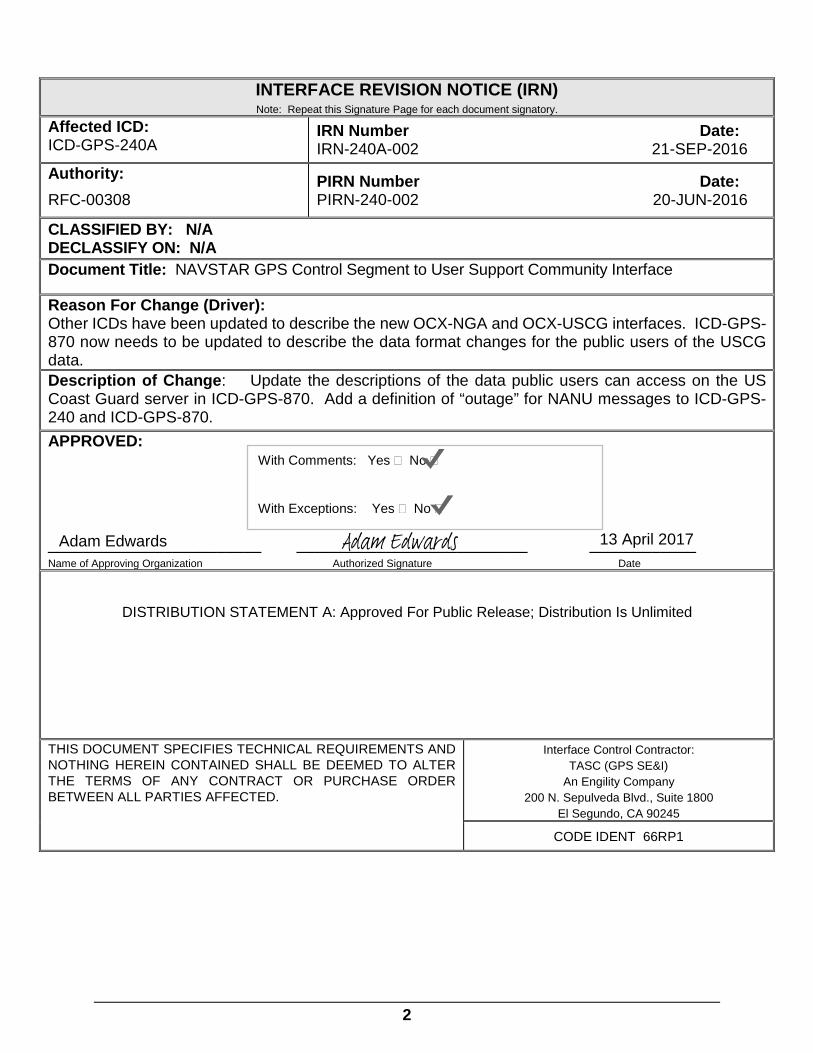
INTERFACE REVISION NOTICE (IRN) Note: Repeat this Signature Page for each document signatory.
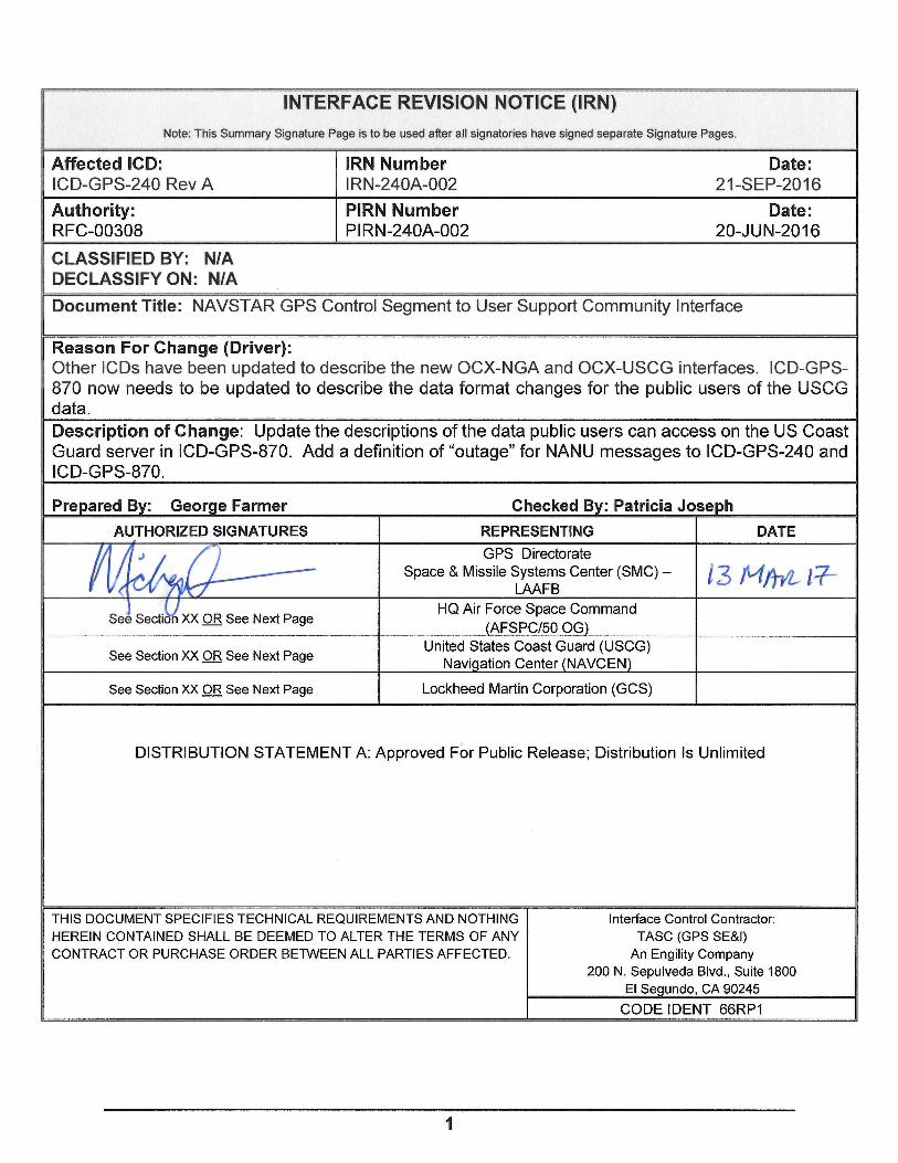
Affected ICD: ICD-GPS-240A
IRN Number Date: IRN-240A-002 21-SEP-2016
Authority: RFC-00308
PIRN Number Date: PIRN-240-002 20-JUN-2016
CLASSIFIED BY: N/A DECLASSIFY ON: N/A Document Title: NAVSTAR GPS Control Segment to User Support Community Interface
Reason For Change (Driver): Other ICDs have been updated to describe the new OCX-NGA and OCX-USCG interfaces. ICD-GPS-870 now needs to be updated to describe the data format changes for the public users of the USCG data. Description of Change: Update the descriptions of the data public users can access on the US Coast Guard server in ICD-GPS-870. Add a definition of “outage” for NANU messages to ICD-GPS-240 and ICD-GPS-870. APPROVED:
________________________ __________________________ ____________ Name of Approving Organization Authorized Signature Date
DISTRIBUTION STATEMENT A: Approved For Public Release; Distribution Is Unlimited
THIS DOCUMENT SPECIFIES TECHNICAL REQUIREMENTS AND NOTHING HEREIN CONTAINED SHALL BE DEEMED TO ALTER THE TERMS OF ANY CONTRACT OR PURCHASE ORDER BETWEEN ALL PARTIES AFFECTED.
Interface Control Contractor: TASC (GPS SE&I)
An Engility Company 200 N. Sepulveda Blvd., Suite 1800
El Segundo, CA 90245
CODE IDENT 66RP1
With Comments: Yes � No �
With Exceptions: Yes � No �
Adam EdwardsAdam Edwards 13 April 2017

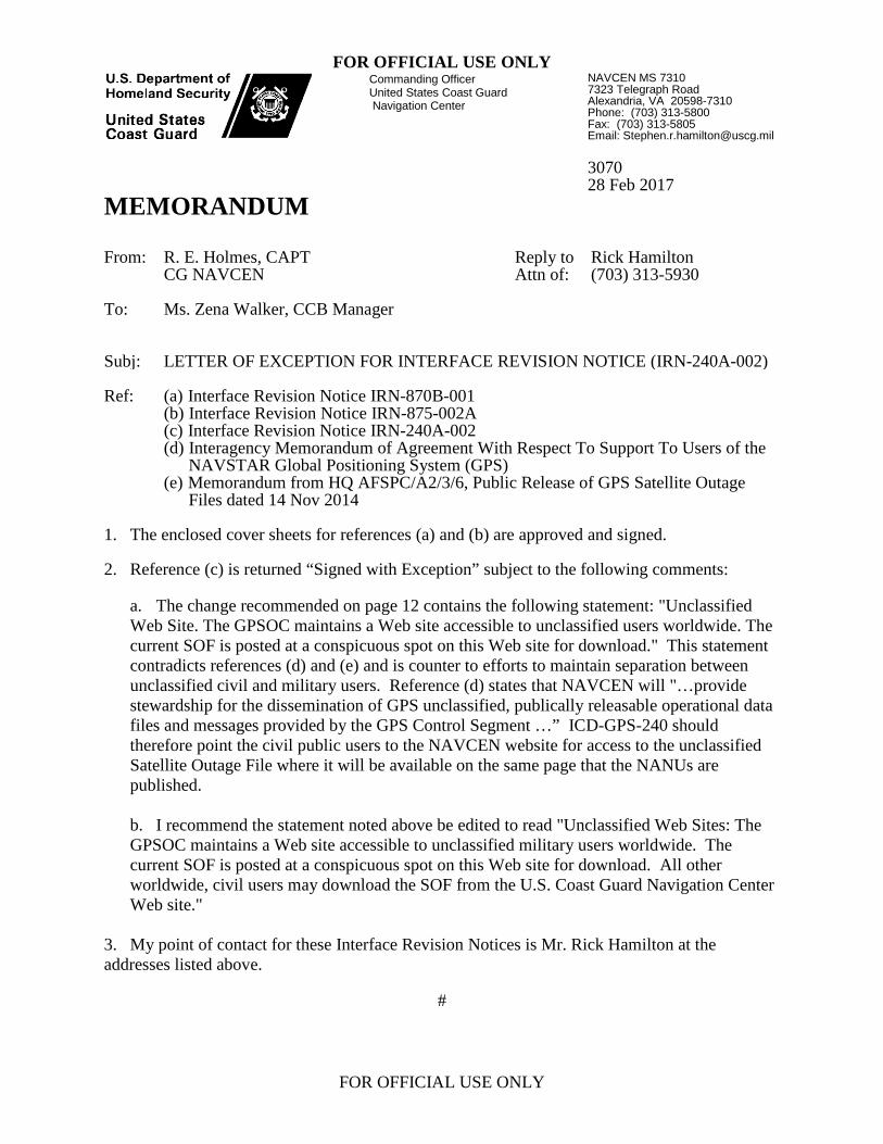
FOR OFFICIAL USE ONLY
FOR OFFICIAL USE ONLY
Commanding Officer United States Coast Guard Navigation Center
NAVCEN MS 7310 7323 Telegraph Road Alexandria, VA 20598-7310 Phone: (703) 313-5800 Fax: (703) 313-5805 Email: [email protected] 3070 28 Feb 2017
MEMORANDUM From: R. E. Holmes, CAPT
CG NAVCEN Reply to Attn of:
Rick Hamilton (703) 313-5930
To: Ms. Zena Walker, CCB Manager
Subj: LETTER OF EXCEPTION FOR INTERFACE REVISION NOTICE (IRN-240A-002) Ref: (a) Interface Revision Notice IRN-870B-001
(b) Interface Revision Notice IRN-875-002A (c) Interface Revision Notice IRN-240A-002 (d) Interagency Memorandum of Agreement With Respect To Support To Users of the
NAVSTAR Global Positioning System (GPS) (e) Memorandum from HQ AFSPC/A2/3/6, Public Release of GPS Satellite Outage
Files dated 14 Nov 2014 1. The enclosed cover sheets for references (a) and (b) are approved and signed.
2. Reference (c) is returned “Signed with Exception” subject to the following comments:
a. The change recommended on page 12 contains the following statement: "Unclassified Web Site. The GPSOC maintains a Web site accessible to unclassified users worldwide. The current SOF is posted at a conspicuous spot on this Web site for download." This statement contradicts references (d) and (e) and is counter to efforts to maintain separation between unclassified civil and military users. Reference (d) states that NAVCEN will "…provide stewardship for the dissemination of GPS unclassified, publically releasable operational data files and messages provided by the GPS Control Segment …” ICD-GPS-240 should therefore point the civil public users to the NAVCEN website for access to the unclassified Satellite Outage File where it will be available on the same page that the NANUs are published. b. I recommend the statement noted above be edited to read "Unclassified Web Sites: The GPSOC maintains a Web site accessible to unclassified military users worldwide. The current SOF is posted at a conspicuous spot on this Web site for download. All other worldwide, civil users may download the SOF from the U.S. Coast Guard Navigation Center Web site."
3. My point of contact for these Interface Revision Notices is Mr. Rick Hamilton at the addresses listed above.
#

Subj: LETTER OF EXCEPTION FOR INTERFACE REVISION NOTICE (IRN-240A-002)
3070
2
Enclosure: (1) IRN-240A-002 Signatory Page
(2) IRN-870B-001 Signatory Page (3) IRN-875-002A Signatory Page
Copy: Mr. George Farmer, Responsible Engineer


3
ICD240-6 :
WAS : The functional data transfer interfaces between the CS and the United States Coast Guard (USCG) Navigation Center (NAVCEN). These interfaces support the Memorandum of Agreement (MOA) between the United States Space Command and the USCG, “Distribution of Navstar Global Positioning System (GPS) Status Information.”
IS : The functional data transfer interfaces between the CS and the United States Coast Guard (USCG) Navigation Center (NAVCEN). These interfaces support the Memorandum of Agreement (MOA) between the UnitedDepartment Statesof SpaceDefense (DoD) Joint Functional Component Command for Space (JFCC SPACE); the Department of Homeland Security (DHS) U.S. Coast Guard Navigation Center (NAVCEN); and the USCGDepartment of Transportation (DOT) Federal Aviation Administration (FAA) National Operations Control Center (NOCC), “DistributionInteragency Memorandum of Agreement with Respect to Support of Users of the Navstar Global Positioning System (GPS) Status Information.”
ICD240-38 :
WAS :
IS-GPS-200 Current Version
Navstar GPS Space Segment/Navigation User Interface
GP-03-001 14 November
2003
GPS Interface Control Working Group (ICWG) Charter
MOA February 1992
Memorandum of Agreement Between the United States Coast Guard and the United States Space Command, “Distribution of Navstar Global Positioning System (GPS) Status Information” (Signatories: USCG/G-NRN and USSPC/DOO)
MOA February 1996
Support Agreement Between the United States Coast Guard and the United States Air Force Space Command, “Distribution of Navstar Global Positioning System (GPS) Status Information” (Signatories: Commanding Officer NAVCEN and AFSPC/DOO)
4
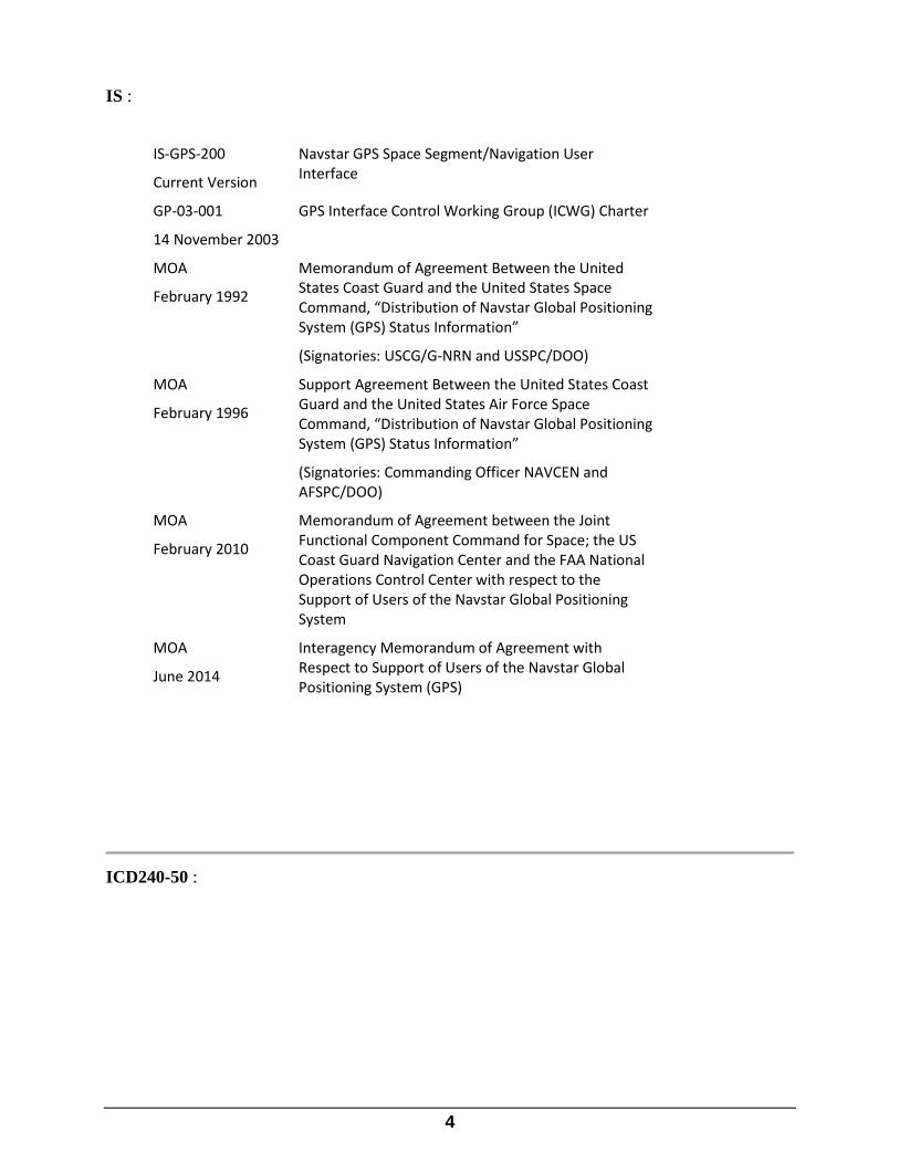
IS :
IS-GPS-200
Current Version
Navstar GPS Space Segment/Navigation User Interface
GP-03-001
14 November 2003
GPS Interface Control Working Group (ICWG) Charter
MOA
February 1992
Memorandum of Agreement Between the United States Coast Guard and the United States Space Command, “Distribution of Navstar Global Positioning System (GPS) Status Information”
(Signatories: USCG/G-NRN and USSPC/DOO)
MOA
February 1996
Support Agreement Between the United States Coast Guard and the United States Air Force Space Command, “Distribution of Navstar Global Positioning System (GPS) Status Information”
(Signatories: Commanding Officer NAVCEN and AFSPC/DOO)
MOA
February 2010
Memorandum of Agreement between the Joint Functional Component Command for Space; the US Coast Guard Navigation Center and the FAA National Operations Control Center with respect to the Support of Users of the Navstar Global Positioning System
MOA
June 2014
Interagency Memorandum of Agreement with Respect to Support of Users of the Navstar Global Positioning System (GPS)
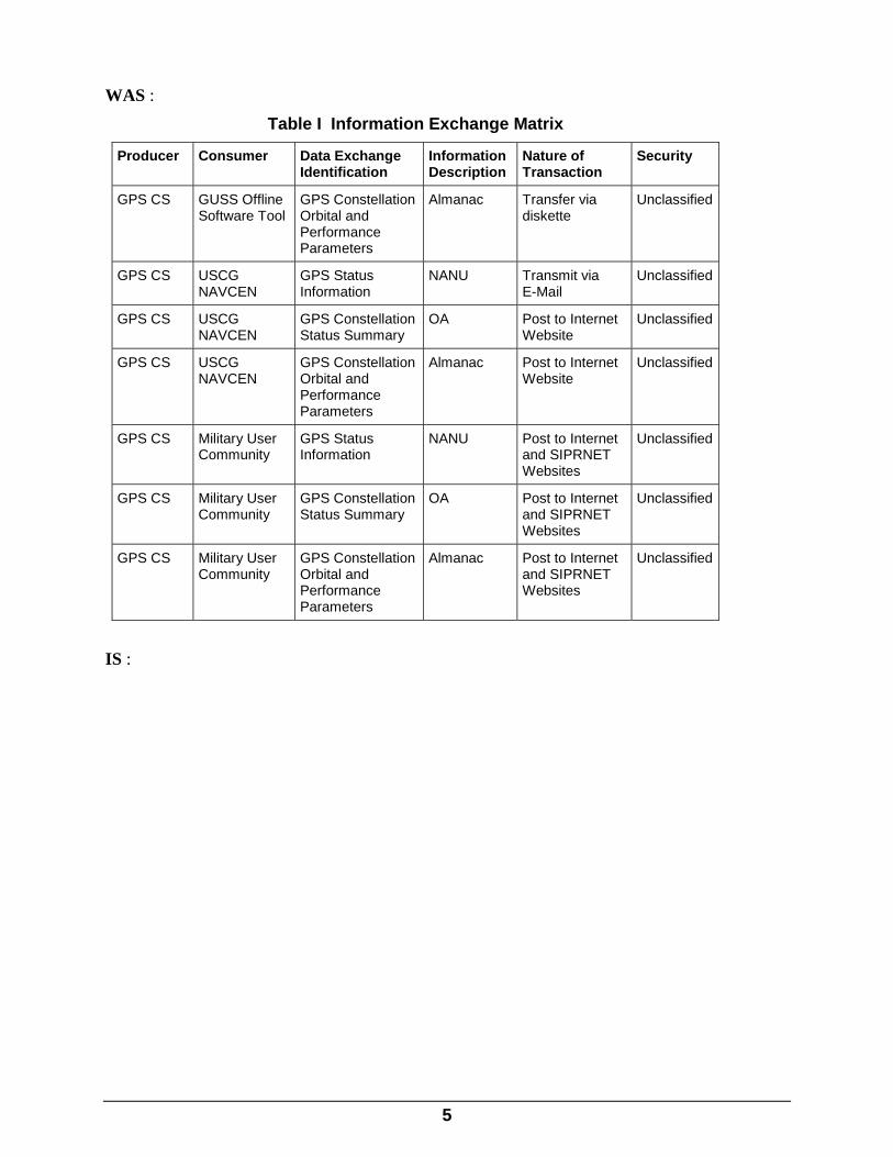
ICD240-50 :
5
WAS :
IS :
Table I Information Exchange Matrix
Producer Consumer Data Exchange Identification
Information Description
Nature of Transaction
Security
GPS CS GUSS Offline Software Tool
GPS Constellation Orbital and Performance Parameters
Almanac Transfer via diskette
Unclassified
GPS CS USCG NAVCEN
GPS Status Information
NANU Transmit via E-Mail
Unclassified
GPS CS USCG NAVCEN
GPS Constellation Status Summary
OA Post to Internet Website
Unclassified
GPS CS USCG NAVCEN
GPS Constellation Orbital and Performance Parameters
Almanac Post to Internet Website
Unclassified
GPS CS Military User Community
GPS Status Information
NANU Post to Internet and SIPRNET Websites
Unclassified
GPS CS Military User Community
GPS Constellation Status Summary
OA Post to Internet and SIPRNET Websites
Unclassified
GPS CS Military User Community
GPS Constellation Orbital and Performance Parameters
Almanac Post to Internet and SIPRNET Websites
Unclassified
6
Table I Information Exchange Matrix
Producer Consumer Data Exchange Identification
Information Description
Nature of Transaction
Security
GPS CS GUSS Offline Software Tool
GPS Constellation Orbital and Performance Parameters
Almanac Transfer via diskette
Unclassified
GPS CS USCG NAVCEN GPS Status Information NANU Transmit via E-Mail
Unclassified
GPS CS USCG NAVCEN GPS Constellation Status Summary
OA Post to Internet Website
Unclassified
GPS CS USCG NAVCEN GPS Constellation Orbital and Performance Parameters
Almanac Post to Internet Website
Unclassified
GPS CS USCG NAVCEN GPS Status Information Satellite Outage File
Post to Internet Website
Unclassified
GPS CS Military User Community
GPS Status Information NANU Post to Internet and SIPRNET Websites
Unclassified
GPS CS Military User Community
GPS Constellation Status Summary
OA Post to Internet and SIPRNET Websites
Unclassified
GPS CS Military User Community
GPS Constellation Orbital and Performance Parameters
Almanac Post to Internet and SIPRNET Websites
Unclassified
GPS CS Military User Community
GPS Status Information Satellite Outage File
Post to Internet and SIPRNET Websites
Unclassified
ICD240-51 :
WAS : The information distributed by the CS includes Notice Advisory to Navstar Users (NANU), Operational Advisory (OA), and satellite almanac. The NANU is a message that informs users of satellite outages and other GPS issues. The OA is a descriptive summary of GPS constellation status. The satellite almanac contains orbital and performance parameters for operational GPS satellites. The primary means of data distribution include electronic mail (e-mail) and Internet and SIPRNET websites. All data transfer described in this ICD is unclassified.

7
IS : The information distributed by the CS includes Notice Advisory to Navstar Users (NANU), Operational Advisory (OA), Satellite Outage File (SOF) and satellite almanac. The NANU is a message that informs users of satellite outages and other GPS issues. The OA is a descriptive summary of GPS constellation status. The SOF is a machine readable format of GPS satellite outage information. The satellite almanac contains orbital and performance parameters for operational GPS satellites. The primary means of data distribution include electronic mail (e-mail) and Internet and SIPRNET websites. All data transfer described in this ICD is unclassified.
ICD240-56 :
WAS : Detailed data formats of the NANU, OA, and almanac data that are referenced in the paragraphs below are described in Appendices 1, 2, and 3 of this ICD, respectively.
IS : Detailed data formats of the NANU, OA, SOF and almanac data that are referenced in the paragraphs below are described in Appendices 1, 2, 3 and 34 of this ICD, respectively.
ICD240-67 :
WAS : NANU messages are transmitted to the USCG NAVCEN via e-mail from the CS to an e-mail address provided by the NAVCEN. The NANUs are transmitted in a tabular format described in Appendix 1. NANU messages are transmitted whenever they are generated (intermittently) including weekends and holidays. Circumstances that may initiate the generation and transmission of specific NANUs are described in Appendix 1. The NANU file is named current.nnu, which is a running list of NANUs.
IS : NANU messages are transmitted to the USCG NAVCEN via e-mail from the CS to an e-mail address provided by the NAVCEN. NANU products from 2SOPS are also received via automated processes that link back to the 2SOPS internet website ((https://gps.afspc.af.mil/gps/archive/). The NANUs are transmitted in a tabular format described in Appendix 1. NANU messages are transmitted whenever they are generated (intermittently) including weekends and holidays. Circumstances that may initiate the generation and transmission of specific NANUs are described in Appendix 1. The NANU file is named current.nnu, which is a running list of NANUs.
8
ICD240-290 : Insertion after object ICD240-68
WAS : N/A
IS : Satellite Outage File (SOF)
ICD240-292 : Insertion below object ICD240-290
WAS : N/A
IS : The Satellite Outage File (SOF) is built by the GPSOC GPSIS (GPS Information Service) to provide a complete and up-to-date statement of past, current, and forecasted satellite outages in the GPS constellation. The information contained in the SOF is based solely on NANUs supplied by the 2 SOPS. It only applies to the GPS satellites managed by the US Air Force, and thus does not reflect status of augmentation satellites, such as those in the WAAS and EGNOS constellations. SOF data is updated and posted to GPSOC GPSIS web sites whenever the GPSOC issues a Notice: Advisory to Navstar Users (NANU).
ICD240-76 :
WAS : Military User Community Internet NANU, OA, and Almanac Interfaces
IS : Military User Community Internet NANU, OA, SOF and Almanac Interfaces
9
ICD240-77 :
WAS : NANUs, OAs, and almanacs are distributed to the Military user community over the internet by uploading NANU, OA, and almanac files to the 2 SOPS internet website. Military users with internet connectivity can access the 2 SOPS internet website directly or via a direct page-to-page hyperlink from the GPS Operations Center (GPSOC) internet website to the 2 SOPS internet website. Files are downloaded from the 2 SOPS internet website using FTP by selecting a hyperlink to the desired NANU, OA, or almanac file.
IS : NANUs, OAs, SOFs and almanacs are distributed to the Military user community over the internet by uploading NANU, OA, SOF and almanac files to the 2 SOPS internet website. Military users with internet connectivity can access the 2 SOPS internet website directly or via a direct page-to-page hyperlink from the GPS Operations Center (GPSOC) internet website to the 2 SOPS internet website. Files are downloaded from the 2 SOPS internet website using FTP by selecting a hyperlink to the desired NANU, OA, SOF or almanac file.
ICD240-78 :
WAS : Military User Community SIPRNET NANU, OA, and Almanac Interfaces
IS : Military User Community SIPRNET NANU, OA, SOF and Almanac Interfaces
ICD240-79 :
WAS : NANUs, OAs, and almanacs are distributed to the Military user community over the SIPRNET by uploading NANU, OA, and almanac files to the GPSOC SIPRNET website. Military users with

10
SIPRNET connectivity can download a NANU, OA, or almanac file using FTP by selecting the corresponding hyperlink.
IS : NANUs, OAs, SOF and almanacs are distributed to the Military user community over the SIPRNET by uploading NANU, OA, SOF and almanac files to the GPSOC SIPRNET website. Military users with SIPRNET connectivity can download a NANU, OA, SOF or almanac file using FTP by selecting the corresponding hyperlink.
ICD240-99 :
WAS :
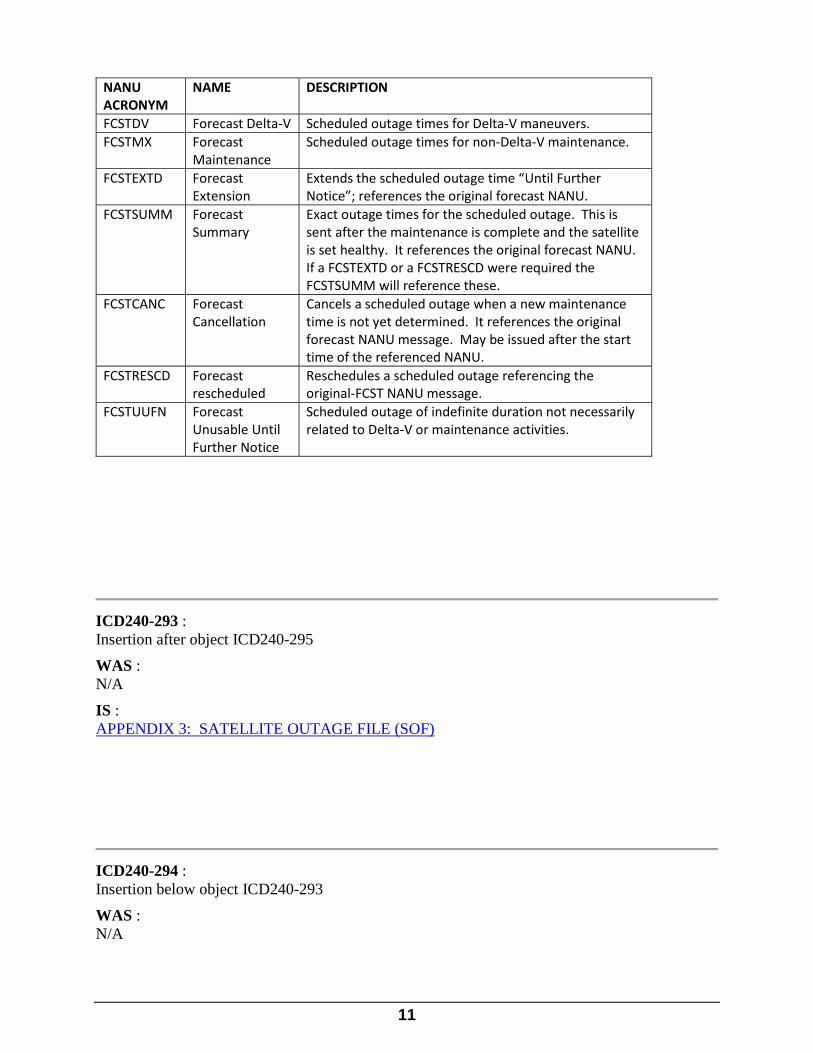
IS :
NANU ACRONYM
NAME DESCRIPTION
FCSTDV Forecast Delta-V Scheduled outage times for Delta-V maneuvers.
FCSTMX Forecast Maintenance
Scheduled outage times for non-Delta-V maintenance.
FCSTEXTD Forecast Extension
Extends the scheduled outage time “Until Further Notice”; references the original forecast NANU.
FCSTSUMM Forecast Summary
Exact outage times for the scheduled outage. This is sent after the maintenance is complete and the satellite is set healthy. It references the original forecast NANU. If a FCSTEXTD or a FCSTRESCD were required the FCSTSUMM will reference these.
FCSTCANC Forecast Cancellation
Cancels a scheduled outage when a new maintenance time is not yet determined; it references the original forecast NANU message.
FCSTRESCD Forecast rescheduled
Reschedules a scheduled outage referencing the original-FCST NANU message.
FCSTUUFN Forecast Unusable Until Further Notice
Scheduled outage of indefinite duration not necessarily related to Delta-V or maintenance activities.
11
NANU ACRONYM
NAME DESCRIPTION
FCSTDV Forecast Delta-V Scheduled outage times for Delta-V maneuvers. FCSTMX Forecast
Maintenance Scheduled outage times for non-Delta-V maintenance.
FCSTEXTD Forecast Extension
Extends the scheduled outage time “Until Further Notice”; references the original forecast NANU.
FCSTSUMM Forecast Summary
Exact outage times for the scheduled outage. This is sent after the maintenance is complete and the satellite is set healthy. It references the original forecast NANU. If a FCSTEXTD or a FCSTRESCD were required the FCSTSUMM will reference these.
FCSTCANC Forecast Cancellation
Cancels a scheduled outage when a new maintenance time is not yet determined. It references the original forecast NANU message. May be issued after the start time of the referenced NANU.
FCSTRESCD Forecast rescheduled
Reschedules a scheduled outage referencing the original-FCST NANU message.
FCSTUUFN Forecast Unusable Until Further Notice
Scheduled outage of indefinite duration not necessarily related to Delta-V or maintenance activities.
ICD240-293 : Insertion after object ICD240-295
WAS : N/A
IS : APPENDIX 3: SATELLITE OUTAGE FILE (SOF)
ICD240-294 : Insertion below object ICD240-293
WAS : N/A

12
IS : Following is a list of the rules or protocols for the SOF data.
Usage Rules
1. The SOF always contains fields identifying creation date/time and reference date/time.
2. A new SOF is built each time a NANU is issued.
3. The latency of the SOF initially may be 15-20 minutes, and is driven by operational procedures and workload.
File Naming Convention
The most recently built SOF is given a standard name that contains the creation date/time and the file format version number, ‘yyyy_ddd_hhmmss_vnn.sof’, where yyyy is the year, ddd is the Jday (day of year starting with 1), hhmmss is the hour/minute/second UTC, and nn is the file format version number. The file format version number will increment sequentially whenever the file format changes.
Dissemination Methods
Unclassified Web Site. The GPSOC maintains a Web site accessible to unclassified users worldwide. The current SOF is posted at a conspicuous spot on this Web site for download.
Classification
The SOF is Unclassified and approved for public release. [Reference GPS Security Classification Guide, 30 Sep 2008, Topic Number 700.7.10]
Format
The SOF is formatted in XML according to the format below. The data type definition (DTD), the data format, and the data field definitions are provided.
A sample SOF with an internal DTD is as follows:
SOF DTD
<?xml version="1.0"?>
<!DOCTYPE GPSISFILE [
<!ELEMENT GPSISFILE (CREATION,REFERENCE,(PREDICTED|CURRENT|HISTORICAL)+)>
<!ELEMENT CREATION EMPTY>
<!ELEMENT REFERENCE EMPTY>
<!ELEMENT PREDICTED EMPTY>
<!ELEMENT CURRENT EMPTY>
<!ELEMENT HISTORICAL EMPTY>

13
<!ATTLIST GPSISFILE FILEID CDATA #FIXED "SOF"> <!ATTLIST GPSISFILE SYSID CDATA #FIXED "GPS">
<!ATTLIST GPSISFILE VERSION CDATA #REQUIRED>
<!ATTLIST CREATION YEAR CDATA #REQUIRED>
<!ATTLIST CREATION DOY CDATA #REQUIRED>
<!ATTLIST CREATION HR CDATA #REQUIRED>
<!ATTLIST CREATION MIN CDATA #REQUIRED>
<!ATTLIST CREATION SEC CDATA #REQUIRED>
<!ATTLIST REFERENCE YEAR CDATA #REQUIRED>
<!ATTLIST REFERENCE DOY CDATA #REQUIRED>
<!ATTLIST REFERENCE HR CDATA #REQUIRED>
<!ATTLIST REFERENCE MIN CDATA #REQUIRED>
<!ATTLIST REFERENCE SEC CDATA #REQUIRED>
<!ATTLIST PREDICTED SVID CDATA #REQUIRED>
<!ATTLIST PREDICTED SVN CDATA #REQUIRED>
<!ATTLIST PREDICTED NAME (NANU|GOCGIS|USER_DEFINED) #REQUIRED>
<!ATTLIST PREDICTED TYPE (FCSTDV|FCSTMX) #REQUIRED>
<!ATTLIST PREDICTED REFERENCE CDATA #REQUIRED>
<!ATTLIST PREDICTED START_YEAR CDATA #REQUIRED>
<!ATTLIST PREDICTED START_DOY CDATA #REQUIRED>
<!ATTLIST PREDICTED START_HR CDATA #REQUIRED>
<!ATTLIST PREDICTED START_MIN CDATA #REQUIRED>
<!ATTLIST PREDICTED START_SEC CDATA #REQUIRED>
<!ATTLIST PREDICTED END_YEAR CDATA #REQUIRED>
<!ATTLIST PREDICTED END_DOY CDATA #REQUIRED>
<!ATTLIST PREDICTED END_HR CDATA #REQUIRED>
<!ATTLIST PREDICTED END_MIN CDATA #REQUIRED>
<!ATTLIST PREDICTED END_SEC CDATA #REQUIRED>
<!ATTLIST CURRENT SVID CDATA #REQUIRED>
<!ATTLIST CURRENT SVN CDATA #REQUIRED>
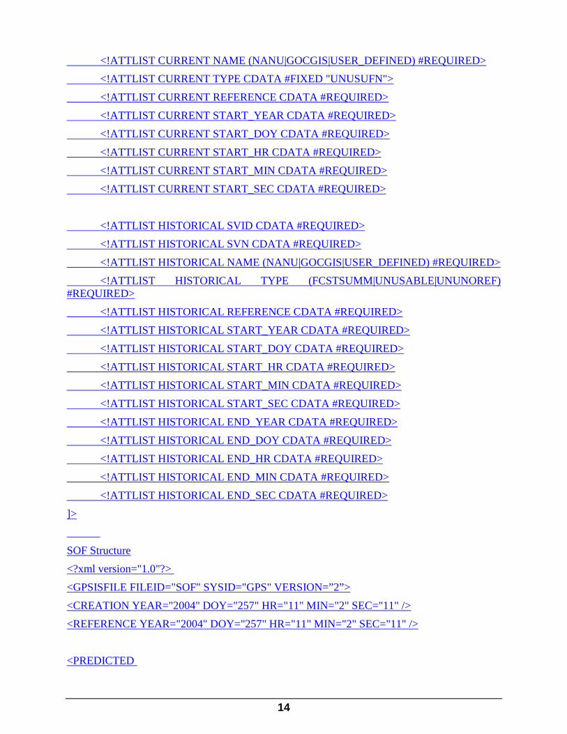
14
<!ATTLIST CURRENT NAME (NANU|GOCGIS|USER_DEFINED) #REQUIRED> <!ATTLIST CURRENT TYPE CDATA #FIXED "UNUSUFN">
<!ATTLIST CURRENT REFERENCE CDATA #REQUIRED>
<!ATTLIST CURRENT START_YEAR CDATA #REQUIRED>
<!ATTLIST CURRENT START_DOY CDATA #REQUIRED>
<!ATTLIST CURRENT START_HR CDATA #REQUIRED>
<!ATTLIST CURRENT START_MIN CDATA #REQUIRED>
<!ATTLIST CURRENT START_SEC CDATA #REQUIRED>
<!ATTLIST HISTORICAL SVID CDATA #REQUIRED>
<!ATTLIST HISTORICAL SVN CDATA #REQUIRED>
<!ATTLIST HISTORICAL NAME (NANU|GOCGIS|USER_DEFINED) #REQUIRED>
<!ATTLIST HISTORICAL TYPE (FCSTSUMM|UNUSABLE|UNUNOREF) #REQUIRED>
<!ATTLIST HISTORICAL REFERENCE CDATA #REQUIRED>
<!ATTLIST HISTORICAL START_YEAR CDATA #REQUIRED>
<!ATTLIST HISTORICAL START_DOY CDATA #REQUIRED>
<!ATTLIST HISTORICAL START_HR CDATA #REQUIRED>
<!ATTLIST HISTORICAL START_MIN CDATA #REQUIRED>
<!ATTLIST HISTORICAL START_SEC CDATA #REQUIRED>
<!ATTLIST HISTORICAL END_YEAR CDATA #REQUIRED>
<!ATTLIST HISTORICAL END_DOY CDATA #REQUIRED>
<!ATTLIST HISTORICAL END_HR CDATA #REQUIRED>
<!ATTLIST HISTORICAL END_MIN CDATA #REQUIRED>
<!ATTLIST HISTORICAL END_SEC CDATA #REQUIRED>
]>
SOF Structure
<?xml version="1.0"?>
<GPSISFILE FILEID="SOF" SYSID="GPS" VERSION=”2”>
<CREATION YEAR="2004" DOY="257" HR="11" MIN="2" SEC="11" />
<REFERENCE YEAR="2004" DOY="257" HR="11" MIN="2" SEC="11" />
<PREDICTED

15
SVID="9" SVN="39" NAME="NANU" TYPE="FCSTMX" REFERENCE="2004094"
START_YEAR="2004" START_DOY="229" START_HR="12" START_MIN="0" START_SEC="0"
END_YEAR="2004" END_DOY="230" END_HR="0" END_MIN="0" END_SEC="0"
/>
<CURRENT
SVID="31" SVN="31"
NAME="NANU" TYPE="UNUSUFN" REFERENCE="2004101"
START_YEAR="2004" START_DOY="257" START_HR="5" START_MIN="50" START_SEC="0"
/>
<HISTORICAL
SVID="27" SVN="27"
NAME="NANU" TYPE="UNUSABLE" REFERENCE="2004100"
START_YEAR="2004" START_DOY="242" START_HR="1" START_MIN="32" START_SEC="0"
END_YEAR="2004" END_DOY="243" END_HR="19" END_MIN="12" END_SEC="0"
/>
</GPSISFILE>
All times are UTC TIME (ZULU) unless otherwise specified. DOY is day of year (same as JDAY); 1=1 January, 366 is valid for leap year
‘GPSISFILE’ FILE INFORMATION
Occurs once per file
FILEID is always ‘SOF’
SYSID is always ‘GPS’
VERSION is the version number of the file. The version text should be an integer version number. Example: 2
CREATION indicates date/time of file creation. Time is computer time (UTC time zone).
16
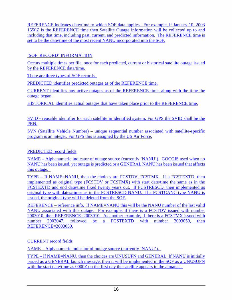
REFERENCE indicates date/time to which SOF data applies. For example, if January 10, 2003 1550Z is the REFERENCE time then Satellite Outage information will be collected up to and including that time, including past, current, and predicted information. The REFERENCE time is set to be the date/time of the most recent NANU incorporated into the SOF.
‘SOF_RECORD’ INFORMATION
Occurs multiple times per file, once for each predicted, current or historical satellite outage issued by the REFERENCE data/time.
There are three types of SOF records.
PREDICTED identifies predicted outages as of the REFERENCE time.
CURRENT identifies any active outages as of the REFERENCE time, along with the time the outage began.
HISTORICAL identifies actual outages that have taken place prior to the REFERENCE time.
SVID - reusable identifier for each satellite in identified system. For GPS the SVID shall be the PRN.
SVN (Satellite Vehicle Number) – unique sequential number associated with satellite-specific program is an integer. For GPS this is assigned by the US Air Force.
PREDICTED record fields
NAME – Alphanumeric indicator of outage source (currently ‘NANU’). GOCGIS used when no NANU has been issued, yet outage is predicted or a GENERAL NANU has been issued that affects this outage.
TYPE – If NAME=NANU, then the choices are FCSTDV, FCSTMX. If a FCSTEXTD, then implemented as original type (FCSTDV or FCSTMX) with start date/time the same as in the FCSTEXTD and end date/time fixed twenty years out. If FCSTRESCD, then implemented as original type with dates/times as in the FCSTRESCD NANU. If a FCSTCANC type NANU is issued, the original type will be deleted from the SOF.
REFERENCE – reference info. If NAME=NANU this will be the NANU number of the last valid NANU associated with this outage. For example, if there is a FCSTDV issued with number 2003010, then REFERENCE=2003010. As another example, if there is a FCSTMX issued with number 2003047, followed be a FCSTEXTD with number 2003050, then REFERENCE=2003050.
CURRENT record fields
NAME – Alphanumeric indicator of outage source (currently ‘NANU’).
TYPE – If NAME=NANU, then the choices are UNUSUFN and GENERAL. If NANU is initially issued as a GENERAL launch message, then it will be implemented in the SOF as a UNUSUFN with the start date/time as 0000Z on the first day the satellite appears in the almanac.
17
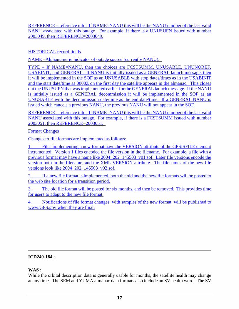
REFERENCE – reference info. If NAME=NANU this will be the NANU number of the last valid NANU associated with this outage. For example, if there is a UNUSUFN issued with number 2003049, then REFERENCE=2003049.
HISTORICAL record fields
NAME –Alphanumeric indicator of outage source (currently NANU).
TYPE – If NAME=NANU, then the choices are FCSTSUMM, UNUSABLE, UNUNOREF, USABINIT, and GENERAL. If NANU is initially issued as a GENERAL launch message, then it will be implemented in the SOF as an UNUSABLE with stop dates/times as in the USABINIT and the start date/time as 0000Z on the first day the satellite appears in the almanac. This closes out the UNUSUFN that was implemented earlier for the GENERAL launch message. If the NANU is initially issued as a GENERAL decommission it will be implemented in the SOF as an UNUSABLE with the decommission date/time as the end date/time. If a GENERAL NANU is issued which cancels a previous NANU, the previous NANU will not appear in the SOF.
REFERENCE – reference info. If NAME=NANU this will be the NANU number of the last valid NANU associated with this outage. For example, if there is a FCSTSUMM issued with number 2003051, then REFERENCE=2003051.
Format Changes
Changes to file formats are implemented as follows:
1. Files implementing a new format have the VERSION attribute of the GPSISFILE element incremented. Version 1 files encoded the file version in the filename. For example, a file with a previous format may have a name like 2004_202_145503_v01.sof. Later file versions encode the version both in the filename, and the XML VERSION attribute. The filenames of the new file versions look like 2004_202_145503_v02.sof.
2. If a new file format is implemented, both the old and the new file formats will be posted to the web site location for a transition period.
3. The old file format will be posted for six months, and then be removed. This provides time for users to adapt to the new file format.
4. Notifications of file format changes, with samples of the new format, will be published to www.GPS.gov when they are final.
ICD240-184 :
WAS : While the orbital description data is generally usable for months, the satellite health may change at any time. The SEM and YUMA almanac data formats also include an SV health word. The SV

18
health word is defined in paragraph 20.3.3.5.1.3 and Table 20-VIII of IS-GPS-200. Table 30-I specifies the binary health words used in SV navigation (NAV) messages and the equivalent decimal representations used by both the SEM and YUMA almanacs. The SV health word is found in cell R-7 of each record in the SEM almanac. It is found on the third line of each record in the YUMA almanac.
IS : While the orbital description data is generally usable for months, the satellite health may change at any time. The SEM and YUMA almanac data formats also include an SV health word. The SV health word is defined in paragraph 20.3.3.5.1.3 and Table 20-VIII of IS-GPS-200. Table 3040-I specifies the binary health words used in SV navigation (NAV) messages and the equivalent decimal representations used by both the SEM and YUMA almanacs. The SV health word is found in cell R-7 of each record in the SEM almanac. It is found on the third line of each record in the YUMA almanac.
ICD240-185 :
WAS : Table 30-I Almanac Health IS : Table 3040-I Almanac Health
ICD240-188 :
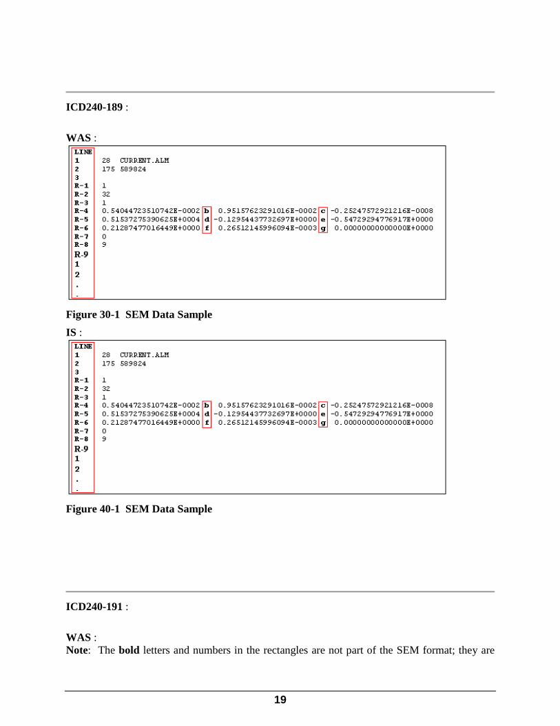
WAS : The SEM format, as shown in Figure 30-1, is arranged with a header that identifies the number of records (number of satellites) and file name (extension .alm). The SEM almanac sample illustrated below is a data sample of one record out of 28 in this sample file.
IS : The SEM format, as shown in Figure 3040-1, is arranged with a header that identifies the number of records (number of satellites) and file name (extension .alm). The SEM almanac sample illustrated below is a data sample of one record out of 28 in this sample file.
19
ICD240-189 :
WAS :
Figure 30-1 SEM Data Sample IS :
Figure 40-1 SEM Data Sample
ICD240-191 :
WAS : Note: The bold letters and numbers in the rectangles are not part of the SEM format; they are

20
used for identification purposes in Table 30-II. Table 30-II identifies the characteristics of each parameter in the SEM almanac.
IS : Note: The bold letters and numbers in the rectangles are not part of the SEM format; they are used for identification purposes in Table 3040-II. Table 3040-II identifies the characteristics of each parameter in the SEM almanac.
ICD240-207 :

21
WAS :
Table 30-II Almanac Description (Sheet 1 of 2)
Line No. Almanac Name Description Units Range Accuracy Precision
1
Number of records
The number of satellite almanac records contained in the file
Records 0 to 32 1 2 significant digits
Name of Almanac
Descriptive name for the Almanac in the file
N/A Any combination of valid ASCII characters
N/A 24 significant characters
2
GPS Week Number
The almanac reference week number (WNa) for all almanac data in the file
Weeks 0 to 1024 * 1 4 significant digits
GPS Time of Applicability
The number of seconds since the beginning of the almanac reference week. The almanac reference time (toa) for all almanac data in the file
Second 0 to 602,112 1 6 significant digits
3 Blank line for format spacing Record Format
R-1 PRN Number The satellite PRN number. This is a required data item as it is the GPS user's primary means of identifying GPS satellites
None 1 to 32 None 2 significant digits
R-2 SVN The SV reference number. It is equivalent to the space vehicle identification (SVID) number of the SV
None 0 to 255 (zero denotes that this field is empty)
None 3 significant digits
R-3 Average URA Number
The satellite "average" URA** number. This is not an item in the raw almanac file but is based on the average URA value transmitted by this satellite in subframe 1. The URA is taken in the range of 730 hours
None 0 to 15 1 2 significant digits
R-4 Eccentricity This defines the amount of the orbit deviation from a circular orbit (e)**
Unitless 0 to 3.125 E-2 4.77 E-7 7 significant digits

22
IS :
Table 40-II Almanac Description (Sheet 1 of 2)
Line No. Almanac Name Description Units Range Accuracy Precision
1
Number of records
The number of satellite almanac records contained in the file
Records 0 to 32 1 2 significant digits
Name of Almanac
Descriptive name for the Almanac in the file
N/A Any combination of valid ASCII characters
N/A 24 significant characters
2
GPS Week Number
The almanac reference week number (WNa) for all almanac data in the file
Weeks 0 to 1024 * 1 4 significant digits
GPS Time of Applicability
The number of seconds since the beginning of the almanac reference week. The almanac reference time (toa) for all almanac data in the file
Second 0 to 602,112 1 6 significant digits
3 Blank line for format spacing Record Format
R-1 PRN Number The satellite PRN number. This is a required data item as it is the GPS user's primary means of identifying GPS satellites
None 1 to 32 None 2 significant digits
R-2 SVN The SV reference number. It is equivalent to the space vehicle identification (SVID) number of the SV
None 0 to 255 (zero denotes that this field is empty)
None 3 significant digits
R-3 Average URA Number
The satellite "average" URA** number. This is not an item in the raw almanac file but is based on the average URA value transmitted by this satellite in subframe 1. The URA is taken in the range of 730 hours
None 0 to 15 1 2 significant digits
R-4 Eccentricity This defines the amount of the orbit deviation from a circular orbit (e)**
Unitless 0 to 3.125 E-2 4.77 E-7 7 significant digits
23
ICD240-194 :
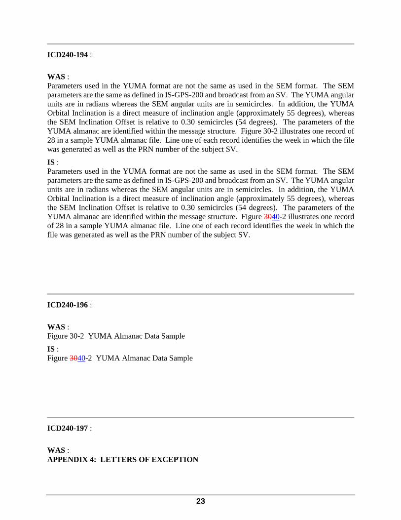
WAS : Parameters used in the YUMA format are not the same as used in the SEM format. The SEM parameters are the same as defined in IS-GPS-200 and broadcast from an SV. The YUMA angular units are in radians whereas the SEM angular units are in semicircles. In addition, the YUMA Orbital Inclination is a direct measure of inclination angle (approximately 55 degrees), whereas the SEM Inclination Offset is relative to 0.30 semicircles (54 degrees). The parameters of the YUMA almanac are identified within the message structure. Figure 30-2 illustrates one record of 28 in a sample YUMA almanac file. Line one of each record identifies the week in which the file was generated as well as the PRN number of the subject SV.
IS : Parameters used in the YUMA format are not the same as used in the SEM format. The SEM parameters are the same as defined in IS-GPS-200 and broadcast from an SV. The YUMA angular units are in radians whereas the SEM angular units are in semicircles. In addition, the YUMA Orbital Inclination is a direct measure of inclination angle (approximately 55 degrees), whereas the SEM Inclination Offset is relative to 0.30 semicircles (54 degrees). The parameters of the YUMA almanac are identified within the message structure. Figure 3040-2 illustrates one record of 28 in a sample YUMA almanac file. Line one of each record identifies the week in which the file was generated as well as the PRN number of the subject SV.
ICD240-196 :
WAS : Figure 30-2 YUMA Almanac Data Sample
IS : Figure 3040-2 YUMA Almanac Data Sample
ICD240-197 :
WAS : APPENDIX 4: LETTERS OF EXCEPTION
24
IS : APPENDIX 45: LETTERS OF EXCEPTION
ICD240-203 :
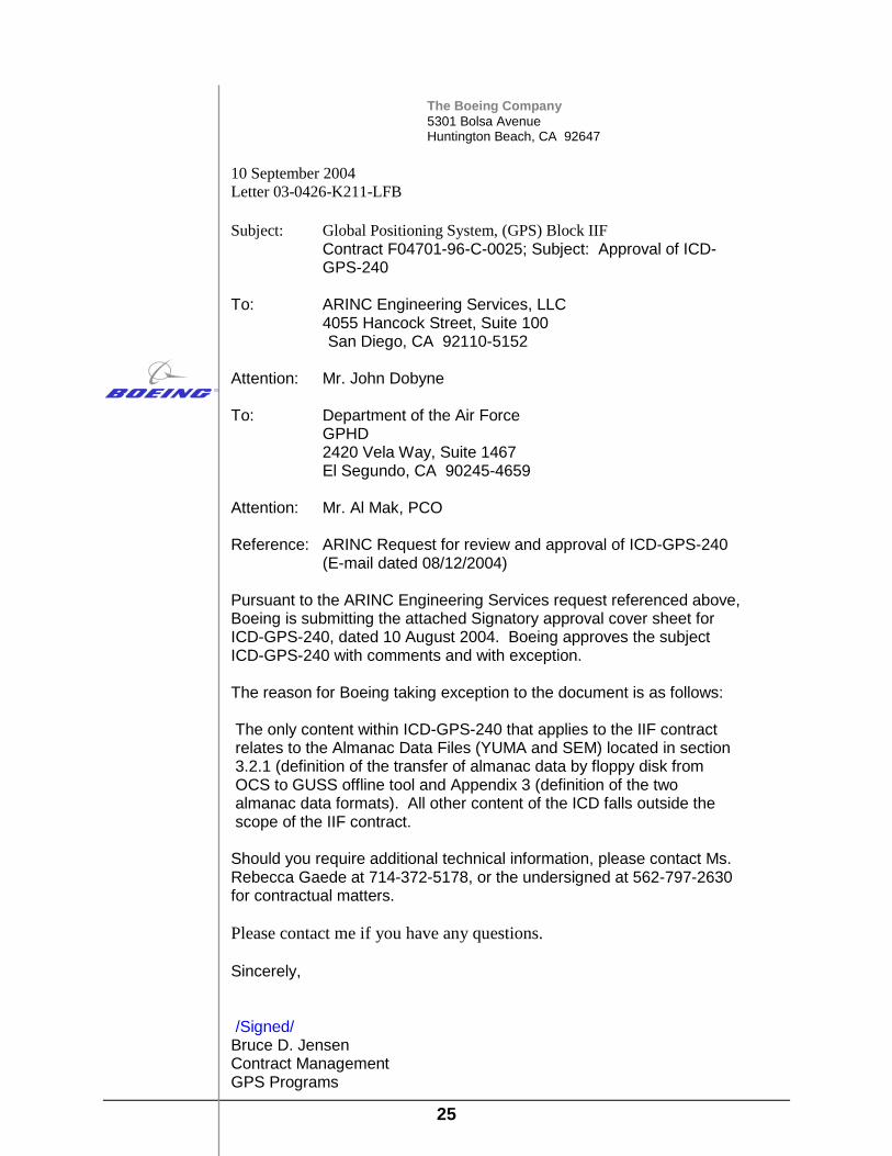
WAS : If signature approval of this document -- as affixed to the cover page -- is marked by an asterisk, it indicates that the approval is contingent upon the exceptions taken by that signatory in a letter of exception. Any letter of exception, which is in force for the revision of the ICD is depicted in Figure 40-1. Signatories for whom no letter of exception is shown have approved this version of the document without exception.
IS : If signature approval of this document -- as affixed to the cover page -- is marked by an asterisk, it indicates that the approval is contingent upon the exceptions taken by that signatory in a letter of exception. Any letter of exception, which is in force for the revision of the ICD is depicted in Figure 4050-1. Signatories for whom no letter of exception is shown have approved this version of the document without exception.
ICD240-204 :
WAS :
25
The Boeing Company 5301 Bolsa Avenue Huntington Beach, CA 92647
10 September 2004 Letter 03-0426-K211-LFB Subject: Global Positioning System, (GPS) Block IIF
Contract F04701-96-C-0025; Subject: Approval of ICD-GPS-240
To: ARINC Engineering Services, LLC 4055 Hancock Street, Suite 100
San Diego, CA 92110-5152
Attention: Mr. John Dobyne To: Department of the Air Force GPHD
2420 Vela Way, Suite 1467 El Segundo, CA 90245-4659
Attention: Mr. Al Mak, PCO Reference: ARINC Request for review and approval of ICD-GPS-240
(E-mail dated 08/12/2004) Pursuant to the ARINC Engineering Services request referenced above, Boeing is submitting the attached Signatory approval cover sheet for ICD-GPS-240, dated 10 August 2004. Boeing approves the subject ICD-GPS-240 with comments and with exception. The reason for Boeing taking exception to the document is as follows: The only content within ICD-GPS-240 that applies to the IIF contract relates to the Almanac Data Files (YUMA and SEM) located in section 3.2.1 (definition of the transfer of almanac data by floppy disk from OCS to GUSS offline tool and Appendix 3 (definition of the two almanac data formats). All other content of the ICD falls outside the scope of the IIF contract. Should you require additional technical information, please contact Ms. Rebecca Gaede at 714-372-5178, or the undersigned at 562-797-2630 for contractual matters. Please contact me if you have any questions. Sincerely, /Signed/ Bruce D. Jensen Contract Management GPS Programs
26
Table 40-I Letter of Exception
IS :

27
The Boeing Company 5301 Bolsa Avenue Huntington Beach, CA 92647
10 September 2004 Letter 03-0426-K211-LFB Subject: Global Positioning System, (GPS) Block IIF
Contract F04701-96-C-0025; Subject: Approval of ICD-GPS-240
To: ARINC Engineering Services, LLC 4055 Hancock Street, Suite 100
San Diego, CA 92110-5152
Attention: Mr. John Dobyne To: Department of the Air Force GPHD
2420 Vela Way, Suite 1467 El Segundo, CA 90245-4659
Attention: Mr. Al Mak, PCO Reference: ARINC Request for review and approval of ICD-GPS-240
(E-mail dated 08/12/2004) Pursuant to the ARINC Engineering Services request referenced above, Boeing is submitting the attached Signatory approval cover sheet for ICD-GPS-240, dated 10 August 2004. Boeing approves the subject ICD-GPS-240 with comments and with exception. The reason for Boeing taking exception to the document is as follows: The only content within ICD-GPS-240 that applies to the IIF contract relates to the Almanac Data Files (YUMA and SEM) located in section 3.2.1 (definition of the transfer of almanac data by floppy disk from OCS to GUSS offline tool and Appendix 3 (definition of the two almanac data formats). All other content of the ICD falls outside the scope of the IIF contract. Should you require additional technical information, please contact Ms. Rebecca Gaede at 714-372-5178, or the undersigned at 562-797-2630 for contractual matters. Please contact me if you have any questions. Sincerely, /Signed/ Bruce D. Jensen Contract Management GPS Programs
28
Table 50-I Letter of Exception