gps pathfinders pre-visit
TRANSCRIPT
1Eagle Bluff Environmental Learning Center Lanesboro, Minnesota www.eagle-bluff.org
GPS Pathfinders Pre-visitClassroom Activity
Brief Synopsis:Technology is constantly changing our lives. GPS units have grown in popularity, yet few fully understand how they work. Learning about the basics of latitude and longitude, along with basic geometry can provide in-sight into this amazing technology.
Ages: Designed for 4th—7th grades
Activity Lengths:Activity 1: 50 minutesActivity 2: 30 minutes
Materials:Activity 1:
Photocopies•Scissors•Pencils•Overhead projector and transparencies •(optional)
Activity 2: Worksheets•Pencils•
Vocabulary: Triangulation, Trilateration, GPS Unit, Latitude, Longitude
Outcomes:Students will gain a basic understanding of 1.triangulation.Students will become familiar with the layout 2.of Eagle Bluff ELC before arriving.Students will practice using latitude and 3.longitude to determine a location on a map.
Minnesota Academic Standards:Math: 5.V.B; 6.V.A; 6.V.B; 7.V.A; 7.V.B; 8.V.A;8.V.B; 9-12.V.A; 9-12.V.B
Activity 1: Triangulation WorksheetBackground:GPS (Global Positioning Systems) units are able to determine their location on Earth by communicating with various orbiting satellites in a process is called triangulation. Triangulation is defined as the method for finding the intersection of three spheres, while trilateration is using the angles of a triangle to determine a location. Both concepts are complicated mathematical processes that we will simplify for the sake of classroom ease and understanding. Using two-dimensional circles to determine distance from various known points will allow students to gain a basic understanding of the complex way GPS units work.
Procedures:Make copies of Worksheets 1-3 and pass them out to the 1.students. Have students cut out the circles on worksheet one. Once the circles are cut, have the students fold them in half twice thus making a pie shaped piece. Using a scissors, the students should snip off a small section of the pointed tip of the pie piece. Unfolding the paper should reveal a circle with a square in the center.Handout worksheet three, which is an actual map of the campus, 2.to determine where the lost children are at Eagle Bluff. The square in the middle of the circle should be placed over the location noted on worksheet two. When all three circles are placed on the map the point at which they all meet is where the lost child is. Have the students mark this point according to the sheet.Check the students’ work according to the key provided.3.

2Eagle Bluff Environmental Learning Center Lanesboro, Minnesota www.eagle-bluff.org
GPS Pathfinders Pre-visit Classroom Activity - Page 2
Activity 2: Latitude Longitude Look-upBackground: GPS units identify location by using coordinates based upon latitude and longitude. While it may seem these coordinates, also known as waypoints, are made up at random, they are actually based upon the shape of the Earth and its division into equal segments (latitude and longitude). Students will become more familiar with latitude and longitude by plotting cities on a world map.
Procedures:Print out Worksheet 4 and distribute to students. 1. Using the coordinates on the page, have students plot cities 2. on the world map. It is up to the discretion of the teacher as to which categories (Easy, Medium, and Hard) students will complete.The longitudinal lines on the map arch to compensate for the 3. spherical shape of the earth. Remind students not to look straight above or below the number indicated on the map, rather to follow the curve of the line.Have students compare results.4.
Discussion:When students participate in the GPS Pathfinders class at Eagle Bluff, they will notice that the coordinates used have additional numbers than those in this activity. In order to be exact, the latitudinal and longitudinal grids are broken down further. Each degree is 60 minutes apart, so location is show in terms of minutes and seconds. Numbers can be shown in two different ways: in minutes (‘) and seconds (“) or decimal notation with fraction (of a minute).
Example:Eagle Bluff Environmental Learning Center CoordinatesPre-vist Activity 2: 43˚N 92˚WMinutes & Seconds: 43˚ 45’31.17” N 92˚ 0’18.63” WDecimal Notation: 43˚ 45.520 N 92˚ 0.311 W
Teacher Tips
Triangulation and trilateration are very •complex mathematical problems. While the first activity doesn’t fully explain these concepts, it will give students a basic understanding.
Cut out examples of the circles used in •Activity 1. These visuals will help students correctly cut the circles and center square without mishaps. Cut the circles out of clear plastic if available.
Feel free to include additional cities in •Activity 2! If you want to include your hometown, coordinate information can be found on http://www.wikipedia.org
Remind students that the vertical lines on •the World Map arch due to the shape of the Earth!
Resources:
http://www.pbs.org/wgbh/nova/shackletonexped/navigate/find.htmlDifferent games help students to understand latitude and longitude. This website does require a plug-in which is available for download.
http://www.cyberbee.com/gps_sites.htmlIf you are looking for a look at GPS units and how they work and can be used, this is a great place to start.
http://www.bcca.org/misc/qiblih/latlong_us.htmlThis website includes the longitude and latitude of major cities in the United States.
http://www.confluence.org/index.phpThis website has pictures an information on different locations where latitudinal and longitudinal lines intersect.

400 m
eters
800 meters
1200 meters
1600 meters
GPS Pathfinders Pre-visit Classroom Activity - Worksheet 1


#1) MARK: -1600 meters from Beginning Orienteering -800 meters from Archery Range -1200 meters from Shiitake
#2) SUSIE -400 meters from Overlook -1200 meters from East Group Challenges site -1600 meters from South Tree Tops
#3 BEN -400 meters west from west-most Parking Lot -1200 meters from Archery -1600 meters from South Tree Tops
#4) JENNA -400 meters from South Tree Tops -800 meters from the southeastern most Pond -1600 meters from Archery Range
#5) SAMUEL -400 meters from River Monitoring -1200 meters from Competitive Orienteering -1600 meters from Susie (#2)
#6) CHLOE -1600 meters from Pioneer Life -1200 meters from Beginning Orienteering -800 meters from Dorm
#7) JACK -800 meters from West Tree Tops -400 meters from the east-most Parking Lot -1200 meters from Jenna (#4)
#8) MAUREEN -800 meters from Volleyball Court -1600 meters from Ridge Oneota -1600 meters from Pioneer Life
#9) EDWARD -800 meters from Pioneer Life -1600 meters from Maureen (#8) -1600 meters from Ben (#3)
#10) DEE -800 meters from Dining Hall -1200 meters from West Group Challenges site -1600 meters from East Group Challenges site
GPS Pathfinders Pre-visit Classroom Activity - Worksheet 1

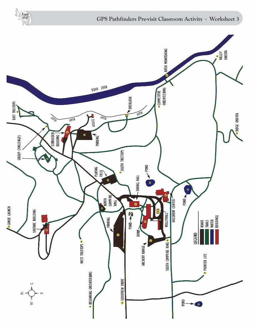
GPS Pathfinders Pre-visit Classroom Activity - Worksheet 3


GPS Pathfinders Pre-visit Classroom Activity - KEY
12
3
4
5
6
7
8
9
10


GPS Pathfinders Pre-visit Classroom Activity - Worksheet 4
HA
RD
Cas
abla
nca,
Mor
occo
33˚N
7˚W
Kra
snoy
arsk
, Rus
sia
56˚N
92˚W
Cha
rles
ton,
SC
, USA
32˚N
79˚W
Bue
nos
Air
es, A
rgen
tina
34˚S
58˚W
Kup
ang,
Ind
ones
ia10
˚S12
3˚E
Cap
e To
wn,
Sou
th A
fric
a33
˚S18
˚W
Car
acas
, Ven
ezue
la10
˚N66
˚W
Cal
gary
, AB
, Can
ada
51˚N
114˚
W
Eag
le B
luff
ELC
43˚N
92˚W
ME
DIU
M
New
Deh
li, I
ndia
28˚N
75˚E
Pert
h, A
ustr
alia
30˚S
115˚
E
Nai
robi
, Ken
ya0˚
36˚E
Mer
ida,
Mex
ico
20˚N
90˚W
Osl
o, N
orw
ay60
˚N10
˚E
Qui
to, E
cuad
or0˚
78˚W
Mon
trea
l, Q
C, C
anad
a45
˚N73
˚W
Sant
a Fe
, NM
, USA
35˚N
105˚
W
EA
SY
New
Orl
eans
, LA
, USA
30˚N
90˚W
St. P
eter
sbur
g, R
ussi
a60
˚N30
˚E
Shan
ghai
, Chi
na30
˚N12
0˚E
Mag
adan
, Rus
sia
60˚N
150˚
E
N’D
jam
ena,
Cha
d15
˚N15
˚E
Vila
Bel
a de
San
tissi
ma
Trin
dade
, Bra
zil
15˚S
60˚W
Port
land
, OR
, USA
45˚N
120˚
W