greater golden hill community plan area - san diego · greater golden hill community plan area 2...
TRANSCRIPT
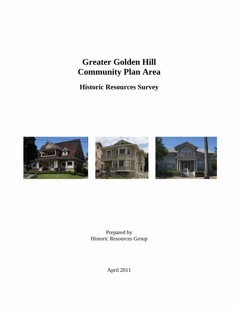
Greater Golden Hill Community Plan Area
Historic Resources Survey
Prepared by Historic Resources Group
April 2011
Greater Golden Hill Community Plan Area
Historic Resources Survey
Prepared for
City of San Diego 202 C Street
San Diego, CA 92101
Prepared by
Historic Resources Group 12 S Fair Oaks Avenue, Suite 200
Pasadena, CA 91105
April 2011

TABLE OF CONTENTS EXECUTIVE SUMMARY .......................................................................................................................... 1 1.0 PROJECT OVERVIEW....................................................................................................................... 2
1.1 INTRODUCTION .............................................................................................................................. 2 1.2 PUBLIC PARTICIPATION................................................................................................................ 2 1.3 SURVEY AREA................................................................................................................................. 3
2.0 METHODOLOGY................................................................................................................................ 5 2.1 LEVEL OF SURVEY ......................................................................................................................... 5 2.2 SURVEY APPROACH....................................................................................................................... 5
3.0 IDENTIFIED HISTORIC RESOURCES ......................................................................................... 11 3.1 POTENTIAL HISTORIC DISTRICTS............................................................................................. 11 3.2 POTENTIAL INDIVIDUAL RESOURCES..................................................................................... 15
4.0 POTENTIAL CONSERVATION AREAS........................................................................................ 22 5.0 RECOMMENDATIONS .................................................................................................................... 24 BIBLIOGRAPHY ...................................................................................................................................... 26 APPENDIX A: DRAFT HISTORIC CONTEXT STATEMENT (CITY OF SAN DIEGO) APPENDIX B: FIELD PHOTO LOG APPENDIX C: PROPERTIES IN POTENTIAL HISTORIC DISTRICTS APPENDIX D: POTENTIAL INDIVIDUAL RESOURCES

Greater Golden Hill Community Plan Area 1 Historic Resources Survey
EXECUTIVE SUMMARY This report presents the results of a historic resources survey conducted in the Greater Golden Hill Community Plan Area. In August 2009, The City of San Diego retained Historic Resources Group (HRG) to complete this survey as part of its community plan update process. HRG conducted a detailed examination of the community plan area, focusing on properties constructed prior to 1970. Surveyors identified properties that appeared eligible for individual designation, as well as geographically-definable areas that appeared eligible for designation as historic districts. All identified properties were evaluated using the City of San Diego’s local designation criteria and documented in an Access database provided by the City. This survey has identified two (2) potential historic districts which meet one or more of the City’s local designation criteria for historical sites, as well as fifty-two (52) individual properties which appear eligible for local designation, including residential (single-family and multi-family), commercial, civic and institutional properties. Finally, the survey proposes two (2) conservation areas, or neighborhood conservation overlay zones, for neighborhoods that do not meet local designation criteria but that possess a unifying or distinctive character that the community wishes to preserve. This project was conducted by Historic Resources Group, including Christy McAvoy, Managing Principal; Kari Michele Fowler, Senior Preservation Planner; Christine Lazzaretto, Senior Architectural Historian; and Paul Travis, Senior Preservation Planner; all of whom meet the Secretary of the Interior's qualifications for professionals in historic preservation.1 The project was managed by Jennifer Hirsch, Senior Planner, and Cathy Winterrowd, Principal Planner, with the City of San Diego’s City Planning and Community Investment Department.
1 Federal Register, Vol. 48, No. 190, pp. 44738-44739, September 29, 1983.

Greater Golden Hill Community Plan Area 2 Historic Resources Survey
1.0 PROJECT OVERVIEW
1.1 INTRODUCTION
In 2008, the City of San Diego completed a comprehensive update of its General Plan, which calls for updates to its various the community plans. Among the stated goals of the community plan updates is the identification of potential historic districts, individual sites, and conservation areas. The City identified the Uptown, Greater North Park, and Greater Golden Hill community plan areas as a single update cluster, with all three community plan updates to take place concurrently. A historic resources survey in each of the three areas was included as part of the update process to identify potential historic resources in order to inform the updated community plans. On August 10, 2009, HRG attended a project kick-off meeting with City staff to begin the historic resources survey for the Greater Golden Hill Community Plan Area. 1.2 PUBLIC PARTICIPATION
The Greater Golden Hill community boasts an interested and involved citizenry that has contributed in various ways to the completion of this historic resources survey. To facilitate public participation, the City established several committees through which community residents, business owners, and other stakeholders could contribute the community update process generally, including the historic resources survey effort. Groups included a Stakeholder Advisory Committee (a sub-committee to Community Planning Group); a Cluster Update Advisory Committee (a joint committee for all three community plan areas being updated); and a Historic Resources Project Working Group. The specific role of the Historic Resources Project Working Group was to provide historic information about the survey area; review draft historic context statements and preliminary survey results; and provide feedback. Throughout the project, the City conducted a number of public workshops and volunteer meetings, as well as meetings with the Historic Resources Working Group and the Cluster Update Advisory Committee, to discuss a range of issues relating to historic preservation in Greater Golden Hill. • On March 20, 2010, HRG participated in the Uptown, Greater North Park and Greater
Golden Hill Cluster Advisory Meeting, a half-day public workshop on urban design & historic resources in the three community plan areas. HRG and City staff provided an introduction to historic resources surveys and described how the Greater Golden Hill survey fit into the larger community plan update process.
• The City hosted a Historic Resources Survey Open House on June 22nd to discuss the status of the survey.
• In early October, the City and its urban design consultant conducted a three-day public design charette for the community plan update. HRG attended the charette on November 6th and presented preliminary results of the historic resources survey for comment.

Greater Golden Hill Community Plan Area 3 Historic Resources Survey
At these events, members of the community were invited to contribute to the survey process by reviewing local library and historical society archives, locating historic photographs, supplying property-specific information, and providing general feedback on draft survey documents. 1.3 SURVEY AREA
The Greater Golden Hill Community Plan Area is one of the older areas of the city. Located east of downtown, the community plan area is bounded by Balboa Park and Juniper Street on the north; State Route 94 on the south; Interstate 5 on the west; and an irregular border roughly following 32nd Street, Marlton Drive, the 34th Street canyon, and Beech Street on the east.2 Greater Golden Hill is characterized by its hilly topography and strict street grid. 30th Street is its main north-south route, and A Street its main east-west route. The area is primarily developed with one- and two-story single-family residences dating from the turn-of-the-last-century through the 1920s, reflecting the popular architectural styles of the day, including Victorian-era styles (Queen Anne, Stick/Eastlake), Craftsman, Spanish Colonial Revival, and Prairie. Many of the area’s larger two-story homes have since been converted into multi-unit buildings. Multi-family residential development includes apartment buildings and residential courts from the teens through the 1920s, with occasional postwar infill. Commercial development is primarily clustered along historical streetcar routes, including 25th, 30th and B Streets. Neighborhood-serving commercial nodes occur at well-traveled intersections, including 28th and B, 30th and Beech, and Fern and Grape Streets. The Greater Golden Hill Community Plan Area contains little institutional or civic development. As noted in the City’s historic context statement for Greater Golden Hill, the community plan area is composed of two distinct communities, Golden Hill and South Park. Golden Hill developed somewhat earlier and was populated by some of the city’s most affluent residents. South Park’s development followed, with more modest homes designed to cater to the middle class:
Golden Hill was first settled in the late 19th century…Initially marketed by real estate speculators as one of San Diego’s finest districts, many of the city’s most esteemed citizens constructed their mansions atop the crest of Golden Hill near the turn of the 20th century. Residential development accelerated, but shifted to [the South Park neighborhood] adjacent to Balboa Park, in the years preceding the highly anticipated Panama-California Exposition of 1915.3
At the start of this project, the Greater Golden Hill Community Plan Area contained approximately 63 individually designated historical sites, and the designated Golden Hill Historic District. 2 Greater Golden Hill Community Plan Update, Draft Historic Context Statement. City of San Diego, City Planning
and Community Investment, June 2010. (2) 3 Greater Golden Hill Community Plan Update, Draft Historic Context Statement. City of San Diego, City Planning
and Community Investment, June 2010. (3)

Greater Golden Hill Community Plan Area 4 Historic Resources Survey
Figure 1. Greater Golden Hill Community Plan Area.
Base map: Golden Hill Community Plan, 1988.
Greater Golden Hill Community Plan Area 5 Historic Resources Survey
2.0 METHODOLOGY
2.1 LEVEL OF SURVEY
A reconnaissance-level survey, as defined by the National Park Service, is a “once over lightly” inspection of an area, the purpose of which is to characterize the area generally as the basis for more detailed survey efforts. General historical research is conducted, such as aerial photos, historical maps, written histories; and field teams would identify basic characteristics of the area, such as extant property types, architectural styles, and street patterns. In contrast, an intensive-level survey includes a detailed inspection of the survey area in order to identify “precisely and completely” all historic resources in an area. Property-specific research is conducted, including historic photos of individual structures and building permits; and all historic properties are documented on California Department of Parks and Recreation (DPR) forms. The historic resources survey for the Greater Golden Hill Community Plan Update is substantially more detailed than a reconnaissance-level survey, but without the degree of documentation required for an intensive-level survey. The purpose of this survey is to identify potentially historic properties within the community plan area for consideration in the community plan update process and for possible future designation. This includes the verification of previously-identified potential historic districts and individual resources, as well as the identification of new historic districts and individual resources. 2.2 SURVEY APPROACH
This survey was conducted using a four-step approach defined by standard preservation practice: STEP 1: RESEARCH Prior to the commencement of fieldwork, HRG conducted a wide range of research. This task included reviewing various relevant City documents (municipal codes and regulations, planning reports, previous historic resources surveys, and various historic nominations); as well as various historical materials (period newspaper articles, photographs, maps).4 The primary historical reference for this survey project was the Greater Golden Hill Community Plan Update, Draft Historic Context Statement, prepared by the City of San Diego City Planning and Community Investment Department. (See Appendix A.) This narrative development history of the area’s built environment, organized by important periods of development, provided a
4 At the public charette for the Greater Golden Hill community plan area, held on November 6, 2010, HRG received
a recently-published history of the South Park community entitled South Park: San Diego, California, by Susan H. Bugbee. Unfortunately, the field survey for this project was already completed by this time and therefore the information in this volume was not incorporated as part of this project.
Greater Golden Hill Community Plan Area 6 Historic Resources Survey
framework for understanding the historical development of this area of the city, and a basis for identifying its potential historic resources.5 STEP 2: FIELDWORK Preliminary field reconnaissance was conducted with City staff on January 25th, 2010, in order to become familiar with the property types and relative levels of integrity to be found in the survey area. HRG then conducted a detailed, property-by-property inspection of the entire community plan area. In particular, HRG examined the following:
• Built resources constructed prior to 1970
• All one-story residential courts
• A potential South Park district and a potential Golden Hill expansion district, both identified in previous surveys 6
• Additional properties identified by members of the community as potentially significant Field teams identified individual properties that appeared eligible for individual designation, as well as geographically-definable areas that appeared eligible for designation as historic districts. For districts, boundaries were defined and contributing and non-contributing resources were identified. Designated properties were not re-surveyed. All fieldwork was conducted from the public right-of-way. Only the primary building on a parcel (the building that fronts the public right-of-way) was surveyed. Any properties that could not be observed from the public right-of-way were not surveyed. Properties that were identified as potentially significant through fieldwork were then evaluated and documented. STEP 3: EVALUATION Designation Criteria All properties identified in the field as potentially eligible for designation were evaluated using the City of San Diego’s local designation criteria.7 The Designation Criteria for City of San Diego Historical Sites are as follows: 5 In August 2009, the City provided HRG with an early draft of the Greater Golden Hill historic context. This draft
described the historical development of Greater Golden Hill, but did not yet include identification of property types, registration requirements or integrity thresholds. HRG received a revised draft containing these components on July 28, 2010, after the identification phase of the field work in Greater Golden Hill had been completed. Field surveyors used the San Diego designation criteria, as well as knowledge gained from the concurrent survey in the Greater North Park community plan area, to identify and evaluate resources in Greater Golden Hill.
6 The 1978 Greater Golden Hill Historic Strategy identified a potential Golden Hill historic district, which was subsequently designated. A potential expansion to this district was identified in 1985 but was not designated. The 1996 Historical Greater Mid-City Preservation Strategy identified a potential South Park historic district, which was not designated.
7 Properties were not evaluated for the California Register of Historical Resources or the National Register of Historic Places.

Greater Golden Hill Community Plan Area 7 Historic Resources Survey
To be designated as historical by the City of San Diego Historical Resources Board, the site must meet any of the following criteria:
A. Exemplifies or reflects special elements of the City's, a community's or a neighborhood's historical, archaeological, cultural, social, economic, political, aesthetic, engineering, landscaping or architectural development.
B. Is identified with persons or events significant in local, state or national history.
C. Embodies distinctive characteristics of a style, type, period or method of construction or is a valuable example of the use of indigenous materials or craftsmanship.
D. Is representative of the notable work of a master builder, designer, architect, engineer, landscape architect, interior designer, artist or craftsman.
E. Is listed or has been determined eligible by the National Park Service for listing on the National Register of Historic Places or is listed or has been determined eligible by the State Historical Preservation Office for listing on the State Register of Historical Resources.
F. Is a finite group of resources related to one another in a clearly distinguishable way or is a geographically definable area or neighborhood containing improvements which have a special character, historical interest or aesthetic value or which represent one or more architectural periods or styles in the history and development of the City.8
Integrity Thresholds In addition to meeting at least one of the designation criteria, a property must retain sufficient integrity to convey its significance. Integrity is the ability of a property to convey its significance; that is, the authenticity of a property’s historic identity as evidenced by the survival of physical characteristics that existed during the property’s historic period.9 The National Park Service has defined the following seven aspects of integrity:
• Location: The place where the historic property was constructed or the place where the historic event occurred.
• Design: The combination of elements that create the form, plan, space, structure, and style of a property.
• Setting: The physical environment of a historic property.
• Materials: The physical elements that were combined or deposited during a particular period of time and in a particular pattern or configuration to form a historic property.
• Workmanship: The physical evidence of the crafts of a particular culture of people during any given period in history or prehistory.
8 City of San Diego Planning Department. “Designation Criteria for City of San Diego Historical Sites.” 9 National Register Bulletin #15: How to Apply the National Register Criteria for Evaluation. Washington D.C.:
U.S. Department of the Interior, National Park Service, 1995. (44-45)

Greater Golden Hill Community Plan Area 8 Historic Resources Survey
• Feeling: A property’s expression of the aesthetic or historic sense of a particular period of time.
• Association: The direct link between an important historic event or person and a historic property.
This survey establishes meaningful integrity thresholds for each of the various property types identified in Greater Golden Hill.10 In order to determine if a property retains integrity, it is necessary first to establish why the property is significant. Because properties are significant for different reasons, separate integrity thresholds have been established for different types of resources. The communities that comprise Greater Golden Hill were developed during the late-19th and early-20th century as residential suburbs, with houses typically designed in one of the popular architectural styles of the period. Single-family residential properties significant for this association were identified as eligible for local designation. Early intact examples of multi-family residential properties were also identified as potential landmarks.11 Similarly, historic districts composed of property types that are common in an area have a higher integrity threshold that those that are composed of types that are rarer. Integrity threshold for district types are described below:
Single-Family Residential Districts Greater Golden Hill is predominantly composed of single-family residences dating from the late-19th and early-20th century. For this reason, integrity thresholds for these resources have been set relatively high. In order for a property to retain high integrity, it must be essentially unaltered, with only very minor or highly reversible alterations. Properties with some alterations – some windows replaced; porch altered; side or rear additions – have moderate integrity. Properties with more substantial alterations – original wall cladding replaced with inappropriate material; original windows removed for inappropriate replacements; large or prominent additions – have low integrity. In order for a grouping of single-family residences to retain sufficient integrity to qualify as a historic district, it must contain a substantial concentration of properties with high integrity, although properties with moderate integrity would also be contributors to the district. Other features that may contribute to a district’s overall integrity include street patterns, uniform setbacks, and landscaping.
10 Note that integrity thresholds that are generally accepted in standard preservation practice today are higher than
they have been in the past. This is particularly true since 2003, when the California Historical Resource Status Codes were revised by the State Office of Historic Preservation.
11 Potentially significant multi-family residences are those that were originally developed with multiple units. Single-family houses that were later subdivided were not considered as multi-family residential development.

Greater Golden Hill Community Plan Area 9 Historic Resources Survey
Residential Court District The residential court – including the pre-war bungalow court and the postwar linear court – is a low-density housing type and therefore examples are increasingly threatened. For this reason, integrity thresholds have been set relatively low. Properties that retain their original wall cladding and window and door openings have moderate integrity and would qualify as contributors to a potential historic district. Commercial Districts The built environment of Greater Golden Hill is overwhelmingly residential, with neighborhood commercial development occurring in small nodes primarily along historical streetcar routes. A substantial geographic concentration of such properties with moderate to high integrity may qualify as a commercial historic district.
Dates of Construction Reliable construction dates are a critical tool in evaluating the significance of potentially historic properties. Because the City does not have available building permits prior to 1955, this survey utilized the construction dates that were pre-loaded into in the City-provided database.12 In some cases these dates did not appear to be accurate, or no date was provided. In these instances, estimated (circa) dates have been assigned based upon field observation. STEP 4: DOCUMENTATION All properties identified as potentially significant – either as an individual site or as a feature of a potential historic district – have been documented in a Microsoft Access database provided by the City. The database was preloaded with baseline parcel information, including parcel addresses; Assessor Parcel Numbers (APNs); and estimated dates of construction. The database also identified designated historic sites. HRG has updated the database so that it contains records only for those properties that have been identified and evaluated as potentially significant for local designation as part of this survey. Properties that were determined to be ineligible for local designation are not documented in the database. All survey data has been provided to the City in this Access database; no State DPR forms have been generated. Database For each documented property, survey information has been verified, updated, or added in the following data fields only:
12 The dates of construction in the City-provided database are from the County tax assessor, which are estimated
based upon building improvement records.

Greater Golden Hill Community Plan Area 10 Historic Resources Survey
DATA FIELD ACTION NUM/STREET Verify/Revise per street or parcel address.13 FULL ADDRESS Verify/Revise to include any alternate street or parcel addresses.ARCHITECTURAL STYLE Add per field observation. YEAR BUILT Verify/Revise per field observation. DESCRIPTION Add property name or other info, if any. ALTERATIONS Add per field observation. (See list below) INTEGRITY Add (low, moderate, high). CRITERIA Add one or more (San Diego Register A-F). NRHP STATUS CODE Add (5B, 5S3, 5D3, 6Z). STATUS Add “Surveyed” for documented properties; Verify
“Designated” for designated properties. CONTRIBUTING Add (individually significant, contributing, non-contributing). DISTRICT NAME Add to all properties (contributors and non-contributors) within
the boundaries of a potential district. IMAGE NAME Add one or more file names using standardized naming
convention (ex. 10272009_001). Noted Alterations In order to ensure an efficient field methodology while maintaining consistency in the data, HRG developed a standardized list of inappropriate alterations to be noted in the field:
Windows replaced Roof material altered Wall cladding replaced Security window bars/doors added Front door replaced Awnings added Storefronts altered Rear addition Porch enclosed Second-story addition
Properties with few or no visible alterations are identified as having “No major alterations.” Properties with numerous alterations are identified as “Substantially altered.” Appropriate modifications, such as the replacement of roof material in kind, are not noted. Photography At least one color digital photograph was taken of each documented property. Photos have been renamed using a standardized naming convention, with the date the photo was taken followed by sequential numbering (ex. 10272009_001). All photos taken during fieldwork are being provided to the City on CD; they are keyed to the survey database and to the attached a photo log. (See Appendix B.)
13 Parcel addresses were provided by the City.

Greater Golden Hill Community Plan Area 11 Historic Resources Survey
3.0 IDENTIFIED HISTORIC RESOURCES14
3.1 POTENTIAL HISTORIC DISTRICTS The survey has identified two (2) potential historic districts which meet one or more of the City’s local designation criteria for historical sites.15 A description of each potential district appears below, along with photos of representative district contributors, and a map defining district boundaries and contributing and non-contributing features.16 (For a complete list of properties contained within the potential historic districts, see Appendix C.)
14 All identified historic resources have been associated with the appropriate context, as outlined in the City of San
Diego’s Greater Golden Hill Community Plan Area Draft Historic Context Statement (June 2010). This historic context statement does not identify themes within the contexts.
15 There is a designated Golden Hill Historic District, first identified in 1978 and revised in 2001. In 1985, a potential expansion to this district was identified. This survey examined this potential expansion area and determined that it does not retain sufficient integrity to merit designation as a local historic district. However, the area does contain a number of residential properties that were identified as potential landmarks.
16 Because the potential Residential Court Thematic Historic District is composed of discontiguous properties, it has not been mapped.
Figure 2. Potential Historic District.

Greater Golden Hill Community Plan Area 12 Historic Resources Survey
South Park Residential Historic District A potential South Park Residential Historic District was identified in 1996, though not designated. While the entirety of this area does not retain sufficient integrity to merit designation as a local historic district, a smaller area was identified as a potential historic district. Eligible under San Diego criterion A, the potential South Park Residential Historic District is an intact grouping of single-family residences developed immediately adjacent to Balboa Park. This potential district is composed of approximately 109 primarily two-story residences, designed in the Craftsman, Prairie, Spanish Colonial Revival and Mediterranean Revival styles. It has a period of significance of 1910 through the 1920s, and is significant under the Streetcar Development: 1905-1930 context. This area includes 15 designated local landmarks.17
17 This potential district comprises the westernmost portion of the original South Park Addition, subdivided in 1906.
The eastern portion of this subdivision comprises the potential South Park Residential Conservation Area described below.
Figure 3. South Park Residential Historic District.

Greater Golden Hill Community Plan Area 13 Historic Resources Survey
Representative district contributors:
1355 Granada Avenue. 1345 Granada Avenue.
1320 Granada Avenue. 1336 Granada Avenue.
1344 Granada Avenue. 1341 29th Street.

Greater Golden Hill Community Plan Area 14 Historic Resources Survey
Residential Court Thematic Historic District18 The potential Residential Court Thematic Historic District is a discontiguous grouping of approximately 19 residential courts located throughout the survey area, eligible under San Diego Criterion A.19 These properties were not developed in geographic clusters. Rather, they were constructed as infill in neighborhoods primarily developed with single-family residences. The potential district has a period of significance of 1920 through the 1950s, and is significant under the Streetcar Development: 1905-1930 and Era of Transitions: 1930-1990 contexts. For the purposes of this survey, the term “residential court” includes both pre-war detached-unit “bungalow courts,” as well as post-war linear courts. Earlier examples were designed in the Craftsman/California Bungalow, Spanish Colonial Revival, and American Colonial Revival style; later examples are Streamline Moderne and Minimal Traditional.20 Representative district contributors:
18 Because this district is composed of discontiguous properties, it has not been mapped. 19 Because this is a thematic and not a geographic district, all of the properties in the district are contributors. 20 The City of San Diego is currently in the process of replacing the thematic district framework with the Multiple
Property Submission (MPS) method for recording discontiguous properties. HRG recommends designating these properties as part of a city-wide MPS for San Diego residential courts.
1225-1243 26th Street.
2208-2222 30th Street.
1730-1738 29th Street.

Greater Golden Hill Community Plan Area 15 Historic Resources Survey
3.2 POTENTIAL INDIVIDUAL RESOURCES In addition to the 63 properties currently designated as individual local historic resources in Greater Golden Hill, this survey has identified fifty-two (52) individual properties which meet one or more of the City’s local designation criteria. These include residential (single-family and multi-family), commercial, civic, and institutional properties. All of these properties are listed below, organized by property type, along with photos of representative examples. (For a complete list of potential individual resources, organized by address, see Appendix D.) Residential Single-Family Residences • 1113-1117 19th Street, 1900. Good example of Victorian-era residential architecture;
significant under the Elite Residential District: 1885-1905 context.
• 905 20th Street, 1895. Good example of late-19th century residential development in Greater Golden Hill; significant under the Elite Residential District: 1885-1905 context.
• 917-919 20th Street, 1888. Good example of late-19th century residential development in Greater Golden Hill; significant under the Elite Residential District: 1885-1905 context.
• 930 20th Street, 1900. Good example of Victorian-era residential architecture; significant under the Elite Residential District: 1885-1905 context.
• 971 20th Street, 1904; significant under the Elite Residential District: 1885-1905 context. Good example of Victorian-era residential architecture.
• 903-909 21st Street, 1905; significant under the Elite Residential District: 1885-1905 context. Good example of Victorian-era residential architecture.
• 1044-1046 21st Street, 1908. Good example of Victorian-era residential architecture; significant under the Streetcar Development: 1905-1930 context.
• 1068-1070 21st Street, 1906. Good example of Victorian-era residential architecture; significant under the Streetcar Development: 1905-1930 context.
• 1143-1145 21st Street, 1904. Good example of Victorian-era residential architecture; significant under the Elite Residential District: 1885-1905 context.
• 849 22nd Street, 1905. Good example of early-20th century residential development in Greater Golden Hill; significant under the Elite Residential District: 1885-1905 context.
• 1042 23rd Street, 1903. Good example of Victorian-era residential architecture; significant under the Elite Residential District: 1885-1905 context.
• 1160 23rd Street, 1905. Good example of Victorian-era residential architecture; significant under the Elite Residential District: 1885-1905 context.
• 832 24th Street, 1900. Good example of Victorian-era residential architecture; significant under the Elite Residential District: 1885-1905 context.

Greater Golden Hill Community Plan Area 16 Historic Resources Survey
• 1930 30th Street, 1900. Good example of Victorian-era residential architecture; significant under the Elite Residential District: 1885-1905 context.
• 2526-2530 A Street, 1905. Good example of Victorian-era residential architecture; significant under the Elite Residential District: 1885-1905 context.
• 2528 B Street, 1900. Good example of Victorian-era residential architecture; significant under the Elite Residential District: 1885-1905 context.
• 2821 B Street, 1905. Good example of Victorian-era residential architecture; significant under the Elite Residential District: 1885-1905 context.
• 2830 B Street, 1908. Good example of Victorian-era residential architecture; significant under the Streetcar Development: 1905-1930 context.
• 2832 Beech Street, 1912. Good example of American Colonial Revival residential architecture; significant under the Streetcar Development: 1905-1930 context.
• 2026 Broadway, 1893. Good example of Victorian-era residential architecture; significant under the Elite Residential District: 1885-1905 context.
• 2227 C Street, 1905. Good example of early-20th century residential development in Greater Golden Hill; significant under the Elite Residential District: 1885-1905 context.
• 2545 C Street. 1908. Good example of Victorian-era residential architecture; significant under the Streetcar Development: 1905-1930 context.
• 2557 C Street, 1920. Good example of Mission Revival residential architecture; significant under the Streetcar Development: 1905-1930 context.
• 1801 Dale Street, 1905. Good example of Victorian-era residential architecture; significant under the Elite Residential District: 1885-1905 context.
• 2148 Dale Street, 1903. Good example of Victorian-era residential architecture; significant under the Elite Residential District: 1885-1905 context.
832 24th Street. 2832 Beech Street.

Greater Golden Hill Community Plan Area 17 Historic Resources Survey
Multi-Family Residences • 953-959 20th Street, 1913. Good example of Renaissance Revival residential architecture;
good example of early-20th century multi-family residential development in Greater Golden Hill; significant under the Streetcar Development: 1905-1930 context.
• 918-922 22nd Street, 1925. Good example of Spanish Colonial Revival residential architecture; good example of early-20th century multi-family residential development in Greater Golden Hill; significant under the Streetcar Development: 1905-1930 context.
• 1150-1156 22nd Street, 1914. Good example of early-20th century multi-family residential development in Greater Golden Hill; significant under the Streetcar Development: 1905-1930 context.
• 840 23rd Street, 1926. Good example of early-20th century multi-family residential development in Greater Golden Hill; significant under the Streetcar Development: 1905-1930 context.
• 970 23rd Street, 1921. Good example of early-20th century multi-family residential development in Greater Golden Hill; significant under the Streetcar Development: 1905-1930 context.
• 1226-1232 23rd Street, 1914. Good example of early-20th century multi-family residential development in Greater Golden Hill; significant under the Streetcar Development: 1905-1930 context.
• 1166-1168 24th Street, 1926. Good example of early-20th century multi-family residential development in Greater Golden Hill; significant under the Streetcar Development: 1905-1930 context.
• 1228-1234 24th Street, 1907. Good example of early-20th century multi-family residential development in Greater Golden Hill; significant under the Streetcar Development: 1905-1930 context.
• 1301 28th Street, El Tovar Apartments, 1929. Good example of Spanish Colonial Revival residential architecture; good example of early-20th century multi-family residential
1930 30th Street. 2026 Broadway.

Greater Golden Hill Community Plan Area 18 Historic Resources Survey
development in Greater Golden Hill; significant under the Streetcar Development: 1905-1930 context.
• 2666-2670 A Street, 1935. Good example of Streamline Moderne residential architecture; significant under the Era of Transitions: 1930-1990 context.
• 2203 B Street, 1908. Good example of early-20th century multi-family residential development in Greater Golden Hill; significant under the Streetcar Development: 1905-1930 context.
• 2502 B Street, 1925. Good example of Spanish Colonial Revival residential architecture; good example of early-20th century multi-family residential development in Greater Golden Hill; significant under the Streetcar Development: 1905-1930 context.
• 2533-2545 B Street, 1909. Good example of early-20th century multi-family residential development in Greater Golden Hill; significant under the Streetcar Development: 1905-1930 context.
• 2664-2668 B Street, 1925. Good example of Spanish Colonial Revival residential architecture; good example of early-20th century multi-family residential development in Greater Golden Hill; significant under the Streetcar Development: 1905-1930 context.
• 2029-2035 Broadway, 1913. Good example of early-20th century multi-family residential development in Greater Golden Hill; significant under the Streetcar Development: 1905-1930 context.
• 2103-2121 Broadway, 1924. Good example of early-20th century multi-family residential development in Greater Golden Hill; significant under the Streetcar Development: 1905-1930 context.
• 2214 Broadway, 1920. Good example of Craftsman residential architecture; good example of early-20th century multi-family residential development in Greater Golden Hill; significant under the Streetcar Development: 1905-1930 context.
• 2102-2116 C Street, 1926. Good example of Spanish Colonial Revival residential architecture; good example of early-20th century multi-family residential development in Greater Golden Hill; significant under the Streetcar Development: 1905-1930 context.
• 2329 C Street, 1928. Good example of Spanish Colonial Revival residential architecture; good example of early-20th century multi-family residential development in Greater Golden Hill; significant under the Streetcar Development: 1905-1930 context.
• 2689-2695 C Street, 1925. Good example of early-20th century multi-family residential development in Greater Golden Hill; significant under the Streetcar Development: 1905-1930 context.

Greater Golden Hill Community Plan Area 19 Historic Resources Survey
Commercial • 2504 C Street, 1935. Good example of early auto-related development in Greater Golden Hill;
significant under the Era of Transitions: 1930-1990 context.
• 2505-2519 C Street, Jaycee’s Market, 1930. Good example of early-20th century commercial development in Greater Golden Hill; significant under the Streetcar Development: 1905-1930 context.
• 2001 Fern Street, 1960, Gala Foods. Good example of Googie commercial architecture in Greater Golden Hill; significant under the Era of Transitions: 1930-1990 context.
2102-2116 C Street. 953-959 20th Street.
918-922 22nd Street. 2533-2545 B Street.
1228-1234 24th Street. 2214 Broadway.

Greater Golden Hill Community Plan Area 20 Historic Resources Survey
• 3015 Juniper Street, 1925. Good example of early-20th century commercial development in Greater Golden Hill; significant under the Streetcar Development: 1905-1930 context.
Civic and Institutional Churches • 2691 B Street, Iglesia Presbiteriana Hispana, 1950. Good example of mid-20th century
institutional development in Greater Golden Hill; significant under the Era of Transitions: 1930-1990 context.
Gala Foods, 2001 Fern Street.
Jaycee’s Market, 2505-2519 C Street.
2504 C Street.

Greater Golden Hill Community Plan Area 21 Historic Resources Survey
• 3025 Fir Street, Christ United Presbyterian Church, 1925. Good example of early-20th century institutional development in Greater Golden Hill; significant under the Streetcar Development: 1905-1930 context.
Fraternal Organizations • 1055 22nd Street, 1935. Good example of early-20th century institutional development in
Greater Golden Hill; significant under the Era of Transitions: 1930-1990 context.
1055 22nd Street. Christ United Presbyterian Church, 3025 Fir Street.

Greater Golden Hill Community Plan Area 22 Historic Resources Survey
4.0 POTENTIAL CONSERVATION AREAS
The survey has identified two (2) potential conservation areas. A conservation area, or neighborhood conservation overlay zone, is a designation typically utilized in neighborhoods that do not meet local criteria for designation as a historic district, but that possess a unifying or distinctive character that the community wishes to preserve.21 Conservation areas possess a strong sense of place based on physical characteristics, though not necessarily on historic fabric. As such, conservations areas preserve neighborhood character, but generally do not provide protection for historic structures. Features often regulated by conservation areas guidelines include overall lot size, lot width at the right-of-way, front and side yard setbacks, and building height. The potential conservation area is described below and is accompanied by a map defining potential area boundaries.22
21 The potential conservation area does not qualify for historic district designation due to poor integrity of individual
properties and a low ratio of contributors to non-contributors. 22 Should the City decide to re-examine the application of its integrity thresholds, and appropriate rehabilitation of
individual properties is undertaken, some potential conservation areas may become eligible for historic designation in the future. However, such an area would need to be re-surveyed, and contributing and non-contributing resources identified, in order to make this determination.
Figure 4. Potential Conservation Areas.

Greater Golden Hill Community Plan Area 23 Historic Resources Survey
South Park Residential Conservation Area Location: Both sides of Dale Street on the west, 31st Street on the east, A Street on the south, and midblock between Cedar and Date Streets on the north.23 Characteristics: • Residential use, single family • Buildings one to two stories in height • Uniform front setbacks • Standardized lot size 30th Street/Juniper Street Commercial Conservation Area Location: Both sides of 30th Street/Fern Street between Kalmia on the north and Ivy on the south.24 Characteristics: • Commercial use, primarily retail • Buildings one to two stories in height • Zero front setback (buildings set at the sidewalk) • Pedestrian orientation and direct communication with the street (building entrances,
windows, etc.)
23 This boundary corresponds to the eastern portion of the original South Park Addition, subdivided in 1906. The
western portion of this subdivision comprises the potential South Park Residential Historic District described above.
24 This potential conservation area straddles the Greater North Park and Greater Golden Hill community plan areas. This report addresses the portion of the conservation area that is in the Greater Golden Hill CPA (south of Juniper) only.

Greater Golden Hill Community Plan Area 24 Historic Resources Survey
5.0 RECOMMENDATIONS
The following are recommendations for the ongoing identification, evaluation and designation of historic resources within the Greater Golden Hill Community Plan Area. These recommendations are based upon standard preservation guidelines and practice as outlined by the National Park Service, the California Office of Historic Preservation, and the National Trust for Historic Preservation, and are consistent with relevant City of San Diego policies and the Historic Preservation Element of the General Plan. Residential Court Multiple Property Submission This survey identified a Residential Court Thematic Historic District composed of thematically-related properties located throughout the Greater Golden Hill community plan area. While the City of San Diego currently has a mechanism for designating “thematic” districts, this is no longer a recognized resource type. Standard preservation practice now uses the Multiple Property Submission (MPS) method to evaluate and document properties that are historically associated but geographically discontinguous. The City of San Diego is currently in the process of replacing the thematic district framework with the MPS method. HRG recommends that the Residential Court Thematic Historic District identified in this survey be designated as part of a city-wide MPS of San Diego residential courts. Properties with Social or Cultural Significance Properties in this survey have been identified primarily as representative of significant patterns of development in Greater Golden Hill, or for their architectural merit (as an excellent example of a building type or architectural style). There may be additional properties within the Greater Golden Hill community plan area which possess historic significance for social or cultural reasons (such an association with an important person or event), which cannot always be established at the survey level. HRG recommends that City staff work with members of the community to identify and evaluate such properties for potential historic designation. “South Park: San Diego,” by Susan Bugbee As noted above, this survey project does not incorporate the information contained in the recently-published local history, South Park: San Diego, California, by Susan H. Bugbee. This volume contains a great deal of property-specific research that could be very useful in identifying additional properties within the Greater Golden Hill community plan area which possess historic significance. HRG recommends that members of the community utilize this valuable resource to identify additional properties that may be eligible for historic designation. Registration Requirements As currently written, the registration requirements outlined in the City’s June 2010 draft of the Greater Golden Hill Historic Context Statement could be broadly interpreted to include a wide range of properties and integrity levels. This is particular relevant to single-family residences, as this property type is so prevalent in Greater Golden Hill. HRG recommends that City staff

Greater Golden Hill Community Plan Area 25 Historic Resources Survey
review these registration requirements to ensure that they establish meaningful thresholds that speak specifically to the resources found in this area of the City.

Greater Golden Hill Community Plan Area 26 Historic Resources Survey
BIBLIOGRAPHY
Amero, Richard W. “The Making of the Panama-California Exposition, 1909-1915.” Journal of San
Diego History 36, no. 1 (1990). Accessed via the San Diego History Center website, https://www.sandiegohistory.org, Dec. 2009.
Booth, Larry and Jane Booth. “Do You Want an Exposition? San Diego’s 1935 Fair in Photographs” Journal of San Diego History 31, no. 4 (1985). Accessed via the San Diego History Center website, https://www.sandiegohistory.org, Dec. 2009.
Bokovoy, Matthew F. The San Diego World’s Fairs and Southwestern Memory, 1880-1940. Albuquerque: University of New Mexico Press, 2005.
California State Military Department. “California Military History: California and the Second World War.” Website: http://www.militarymuseum.org/HistoryWWII.html. Accessed February 2010.
Christman, Florence. The Romance of Balboa Park. San Diego: Neyenesch Printers, Inc., 1973.
Ciani and Somerville Design Associates. Golden Hill Planned District, Historic Preservation Study and Evaluation, Apr. 1984.
City of San Diego. “Designation Criteria for City of San Diego Historical Sites.” Website: http://www.sandiego.gov/planning/programs/historical/requirements/. Accessed: December 2009.
———. City Planning and Community Investment. Greater Golden Hill Community Plan Update, Draft Historic Context Statement, Aug. 2009.
———. City Planning and Community Investment. Greater Golden Hill Community Plan Update, Draft Historic Context Statement, Jun. 2010.
———. Historic Preservation Ordinance, no date.
———. Historic Resources Board. Biographies of Established Masters. Ginger Weatherford, MPS; Tricia Olsen, MCP; Ricki Siegel; Historical Resources Board Staff, 12 May 2008 (Revised 9 July 2009).
———. Historic Resources Board. Historical District Policy on Establishing Historical Districts, 2002.
———. Historic Resources Board. List of Established Masters, 19 Nov. 2008.
———. Parks and Recreation Department. “Balboa Park History: San Diego’s Urban Jewel.” Website: http://www.sandiego.gov/park-and-recreation/parks/balboa/history.shtml. Accessed February 2010.
———. Planning Department. City of San Diego General Plan, updated Mar. 2008.
———. Planning Department. City of San Diego Historic Preservation Element, Mar. 2008.
———. Planning Department. Greater Golden Hill Historic District, Jan. 2001.
———. Planning Department. Historic District Nomination Guidelines, 2008.
———. Planning Department. San Diego Modernism Historic Context Statement, 17 Oct. 2007.
———. Planning Department and the Golden Hill Community Planning Committee. Golden Hill Community Plan, 1988.
Curtis, James R. and Larry Ford, “Bungalow Courts in San Diego: Monitoring a Sense of Place,” The Journal of San Diego History, Volume 34, Number 2, Spring 1988.
Greater Golden Hill Community Plan Area 27 Historic Resources Survey
Donaldson, Milford Wayne, IS Architecture, and RNP/Roesling Nakamura Architects. Historical Greater Mid-City San Diego Preservation Strategy. San Diego: City of San Diego, 1996.
Eddy, Lucinda. “War Comes to San Diego.” Journal of San Diego History 39, no. 1-2 (1993). Accessed via the San Diego History Center website, https://www.sandiegohistory.org, Dec. 2009.
Enneking, William C. “Those Fabulous Cable-Cars.” Journal of San Diego History 2, no. 1 (1956). Accessed via the San Diego History Center website, https://www.sandiegohistory.org, Dec. 2009.
Flanigan, Kathleen. “William Sterling Hebbard: Consummate San Diego Architect.” Journal of San Diego History 33, no. 1 (1987). Accessed via the San Diego History Center website, https://www.sandiegohistory.org, Dec. 2009.
Fredrich, Barbara E. “The Cobblestone Connection in San Diego's Architectural History.” Journal of San Diego History 35, no. 1 (1989). Accessed via the San Diego History Center website, https://www.sandiegohistory.org, Dec. 2009.
Mills, James R. San Diego: Where California Began. Accessed via the San Diego History Center website, https://www.sandiegohistory.org, Dec. 2009.
Montes, Gregory E. “San Diego’s City Park, 1868-1902: An Early Debate on Environment and Profit.” Journal of San Diego History 23, no. 2 (1977). Accessed via the San Diego History Center website, https://www.sandiegohistory.org, Dec. 2009.
National Register Bulletin 15: How to Apply the National Register Criteria. Washington D.C.: U.S. Department of the Interior, National Park Service, 1995.
National Register Bulletin 16A: How to Complete the National Register Form. Washington D.C.: U.S. Department of the Interior, National Park Service 1997.
“Our Public Park” San Diego Union, November 4, 1869.
Pourade, Richard F. The History of San Diego. Accessed via the San Diego History Center website, https://www.sandiegohistory.org, Dec. 2009.
Pryde, Philip R., ed. San Diego: An Introduction to the Region. 2nd edition. Dubuque: Kendall/Hunt Publishing Company, 1984.
Sanborn Map Company. Insurance Maps of San Diego, 1921, 1956.
Smythe, William E. History of San Diego 1542-1908: Volume I. Old Town. San Diego: The History Company, 1908.
———. History of San Diego 1542-1908: Volume II. The Modern City. San Diego: The History Company, 1908.
Starr, Raymond G. San Diego: A Pictorial History. Norfolk, Va.: The Donning Company/Publishers, 1986.
Wexler, Geoffrey B. “A Few More Pieces of the Puzzle: Collections Documenting San Diego History at the University of California, San Diego.” Journal of San Diego History 37, no. 1 (1991). Accessed via the San Diego History Center website, https://www.sandiegohistory.org, Dec. 2009.

Greater Golden Hill Community Plan Area 28 Historic Resources Survey
APPENDICES
APPENDIX A: Draft Historic Context Statement (City of San Diego)
APPENDIX B: Field Photo Log
APPENDIX C: Properties in Potential Historic Districts
APPENDIX D: Potential Individual Resources

Greater Golden Hill Community Plan Area Appendix A-1 Historic Resources Survey
APPENDIX A: Draft Historic Context Statement (City of San Diego)
GG RR EE AATT EE RR GGOO LL DD EE NN HH II LL LL CC OO MM MM UU NN II TT YY PPLL AA NN
UU PP DD AATT EE
DDRR AA FF TT HH II SS TTOO RR II CC CCOO NN TT EE XX TT SSTTAATT EE MM EE NN TT
JJ UU NN EE 22001100
CC IITTYY OOFF SSAANN DD IIEEGGOO
CC IITTYY PPLLAANNNNIINNGG AANNDD CCOOMMMMUUNNIITTYY IINNVVEESSTTMMEENNTT
220022 CC SSTTRREEEETT
SSAANN DD IIEEGGOO ,, CCAALLIIFFOORRNNIIAA 9922110011

Dra f t H i s t o r i c Co n t e x t S t a t emen t
G r e a t e r Go l d e n H i l l Commun i t y P l a n Upda t e
-1-
TABLE OF CONTENTS
PROJECT OVERVIEW ...............................................................................................................2
A. Introduction and Definition of Geographic Area ..............................................................2
B. Research Design and Methodology .....................................................................................4
C. Identification of Historic Contexts and Periods of Significance ......................................5
D. Evaluation Criteria ..............................................................................................................5
HISTORIC CONTEXT .................................................................................................................8
A. The Early History of Greater Golden Hill: 1769-1885 .....................................................8
B. An Elite Residential District: 1885-1905 ..........................................................................13
C. Streetcar Development: 1905-1930 ...................................................................................21
D. An Era of Transitions: 1930-1990 .....................................................................................38
BIBLIOGRAPHY ........................................................................................................................50

Dra f t H i s t o r i c Co n t e x t S t a t emen t
G r e a t e r Go l d e n H i l l Commun i t y P l a n Upda t e
-2-
PROJECT OVERVIEW
A. INTRODUCTION AND DEFINITION OF GEOGRAPHIC AREA
Purpose and Scope of the Historic Context:
This historic context statement applies to the Greater Golden Hill Community Planning Area,
and was prepared in support of the City of San Diego’s Greater Golden Hill Community Plan
Update. The information contained herein will be used to identify locations within the Planning
Area that may contain significant historical resources. In addition, this document will be used to
shape the Historic Preservation element of the Community Plan Update. The prehistoric context
and archaeological resources in Golden Hill will be addressed in a separate document.
The Greater Golden Hill Community Planning Area (Planning Area) is situated within San
Diego’s urban core. Located to the east of downtown and adjacent to Balboa Park, the Planning
Area occupies 441 acres and encompasses the communities of Golden Hill and South Park.1
More specifically, the Planning Area is bounded by Balboa Park and Juniper Street on the north;
State Route 94 on the south; Interstate 5 on the west; and an irregular border roughly following
32nd
Street, Marlton Drive, the 34th
Street canyon, and Beech Street on the east.
The study area is illustrated in Figure 1.
1 Greater Golden Hill Planning Committee and City of San Diego Planning Department, Golden Hill Community Plan (1988), 1.
Figure 1. Map of the Greater Golden Hill Planning Area, showing boundaries. Source: Golden Hill Community Plan, 1988

Dra f t H i s t o r i c Co n t e x t S t a t emen t
G r e a t e r Go l d e n H i l l Commun i t y P l a n Upda t e
-3-
Aside from topography and location, the communities within the Planning Area – Golden Hill
and South Park – are remarkably distinct. To account for differences in neighborhood character
and provide a sense of orientation, this historic context distinguishes between the central and
northeastern sections of the Planning Area. Generally, “central Golden Hill” refers to the
neighborhood of Golden Hill proper, and includes the area south of Balboa Park and “A” Street.
On the other hand, “northeastern Golden Hill” encompasses the community of South Park, and
lies east of Balboa Park and north of “A” Street. These boundaries are illustrated in Figure 2.
Historical Overview of the Planning Area:
Golden Hill was settled in the late 19th
century, and is largely significant with regard to its
residential history. Initially marketed by real estate speculators as one of San Diego’s finest
districts, many of the city’s most esteemed citizens constructed their mansions atop the crest of
Golden Hill near the turn of the 20th
century. Residential development accelerated, but shifted to
the northeastern portion of the Planning Area adjacent to Balboa Park, in the years preceding the
highly anticipated Panama-California Expedition of 1915. Replete with single-family homes
designed in an eclectic mix of architectural styles, the majority of Golden Hill was built to
capacity by 1930.
CENTRAL GOLDEN HILL NORTHEASTERN GOLDEN HILL
LEGEND
Figure 2. Map of the central and northeastern sections of Greater Golden Hill. Source: Golden Hill Community Plan, 1988

Dra f t H i s t o r i c Co n t e x t S t a t emen t
G r e a t e r Go l d e n H i l l Commun i t y P l a n Upda t e
-4-
In the years following the Great Depression, Golden Hill experienced a period of decline and
marked physical change. Responding to a chronic housing shortage which arose in San Diego at
the height of World War II, city officials rezoned much of the Planning Area to accommodate
high-density residential development. Due to these zoning codes, many of the neighborhood’s
large mansions were replaced with large multifamily complexes, while others were subdivided
into multiple units.
Today, Golden Hill is best characterized in terms of its diversity. In addition to housing a wide
variety of income levels and ethnic groups, the community boasts a built environment that is
equally as eclectic. The built environment reflects the history of the community as many of San
Diego’s oldest and most dignified mansions are located in Golden Hill alongside modest
bungalows, apartment homes and contemporary commercial enterprises. In general, the southern
and western ends of the Planning Area are characterized by a diverse built environment, while
the northeastern section – which encompasses South Park – has retained a cohesive collection of
the Planning Area’s early housing.
B. RESEARCH DESIGN AND METHODOLOGY:
This historic context statement was developed primarily through archival research, and
synthesizes information collected from a variety of primary and secondary materials. In addition
to consulting the historical resource files at the City Planning and Community Investment
Department and the archives at Save Our Heritage Organisation, research was conducted at the
San Diego Public Library, the San Diego Historical Society, and the libraries at the University of
California, San Diego.
Primary sources included historic maps, photographs and newspapers, and media advertisements.
Specifically, subdivision maps, in conjunction with Sanborn Fire Insurance Maps, were used to
establish broad patterns of development within Golden Hill. Historic photographs provided
imagery of the community’s evolving landscape and predominant architectural styles. Other
primary materials included several articles, advertisements and editorials from the archives of the
Los Angeles Times and San Diego Union.
Secondary sources of information were consulted to supplement these primary materials, and
included later accounts of history recorded in a variety of books, essays, journals and master’s
theses. While some of these sources – including essays recanting the histories of Golden Hill and
South Park – provide information specific to Greater Golden Hill, others discuss the
development of the Planning Area within the broader context of San Diego history.

Dra f t H i s t o r i c Co n t e x t S t a t emen t
G r e a t e r Go l d e n H i l l Commun i t y P l a n Upda t e
-5-
C. IDENTIFICATION OF HISTORIC CONTEXTS AND PERIODS OF SIGNIFICANCE:
The Greater Golden Hill Community Planning Area embodies several historic contexts, each of
which reflects a significant pattern of development within the community. While some of these
contexts are unique to the Planning Area, others convey larger historical trends and can be
applied to additional areas within the city. Generally, the following four contexts and periods of
significance adhere to a chronological framework, though some periods overlap:
The Early History of Greater Golden Hill: 1769-1885
An Elite Residential District: 1885-1905
Streetcar Development: 1905-1930
An Era of Transitions: 1930-1990
Each of these contexts and periods of significance, as well as their corresponding property types,
are laid out in further detail in the following section.
D. EVALUATION CRITERIA
City of San Diego Register
Although based on NRHP and CRHR criteria, the City of San Diego designation criteria differ in
order and quantity from the federal and state registers. The Historical Resources Guidelines of
the Land Development Manual (a supplement to the Municipal Code) states that any
improvement, building, structure, sign, interior element, fixture, feature, site, place, district or
object may be designated as historical by the City of San Diego Historical Resources Board
(HRB) if it meets one or more of the following criteria:
A. Exemplifies or reflects special elements of the City's, a community's or a neighborhood's
historical, archaeological, cultural, social, economic, political, aesthetic, engineering,
landscaping or architectural development.
B. Is identified with persons or events significant in local, state or national history.
C. Embodies distinctive characteristics of a style, type, period or method of construction or
is a valuable example of the use of indigenous materials or craftsmanship.
D. Is representative of the notable work of a master builder, designer, architect, engineer,
landscape architect, interior designer, artist or craftsman.
E. Is listed or has been determined eligible by the National Park Service for listing on the
National Register of Historic Places or is listed or has been determined eligible by the
California State Office of Historic Preservation for listing on the California Register of
Historical Resources.

Dra f t H i s t o r i c Co n t e x t S t a t emen t
G r e a t e r Go l d e n H i l l Commun i t y P l a n Upda t e
-6-
F. Is a finite group of resources related to one another in a clearly distinguishable way or is
a geographically definable area or neighborhood containing improvements which have a
special character, historical interest or aesthetic value or which represent one or more
architectural periods or styles in the history and development of the City.
In addition to meeting one or more of the above criteria, a City of San Diego Register-eligible
property must also retain sufficient integrity to convey its significance. Although the City’s
municipal code does use a 45 year threshold to review properties which may be adversely
impacted by development, a property need not be 45 years of age to be eligible for listing on the
City’s register. In addition, the recently adopted Guidelines for the Application of Historical
Resources Board Designation Criteria provide guidance on the application of local designation
criteria.
Though the order and quantity of the San Diego criteria differ from the NRHP and California
CRHR the following parallel relationships can be established:
NRHP and CRHR
Criteria
San Diego (HRB) Criteria
Criterion A/Criterion 1 HRB Criterion B (events)
Criterion B/Criterion 2 HRB Criterion B (persons)
Criterion C/Criterion 3 HRB Criteria C and D
Criterion D/Criterion 42 HRB Criterion A (archaeology)
HRB Criterion A is not directly addressed through NRHP or CRHR criteria as it refers to a
special element of the City’s, a community’s, or a neighborhood’s historical, cultural, social,
economic, political, aesthetic, engineering, landscaping, or architectural development . As stated
in the Guidelines for the Application of Historical Resources Board Designation Criteria
adopted by the City’s HRB, “Special elements of development refer to a resource that is distinct
among others of its kind or that surpass the usual in significance.” When Criterion A is applied
to archaeological resources it does closely align with NRHP Criterion D or CRHR Criteria 4.
Therefore, this document will consider HRB Criterion A separately from the other NRHP/CRHR
criterion within the registration requirements for each property type.
HRB Criterion E is only applied to properties determined eligible for the NRHP or CRHR;
therefore, registration requirements related to this criterion are not necessary. In addition, HRB
Criterion F is applied to contributors in historic districts, but the district is determined eligible
under one of the other criteria (HRB A-D); therefore registration requirements will not be
addressed in this document.
2 NRHP Criterion D and CRHR Criterion 4 typically apply to archaeological resources. The pre-contact period of
Golden Hill will be addressed in a separate document and analysis under this criterion will be addressed at that time.

Dra f t H i s t o r i c Co n t e x t S t a t emen t
G r e a t e r Go l d e n H i l l Commun i t y P l a n Upda t e
-7-
Integrity
In addition to establishing significance, resources must have historical “integrity.” Integrity is
defined as the ability of a resource to convey its significance through the property’s physical
features and how those features relate to the property’s significance within its “period of
significance.” For historic resources a “period of significance” is the date or span of time which
reflects the significance of the architecture; or within which significant events transpired or
significant individuals made their important contributions in relation to the resource in question.
The seven aspects of integrity include location, design, setting, materials, workmanship, feeling,
and association. These aspects of integrity are defined in the National Register Bulletin: How to
Apply the National Register Criteria for Evaluation as follows:
Location is the place where a resource was constructed or where an event occurred.
Design results from intentional decisions made during the conception and planning of a
resource. Design includes form, plan, space, structure, and style of a property.
Setting applies to a physical environment, the character of a resource’s location, and a
resource’s relationship to the surrounding area.
Materials comprise the physical elements combined or deposited in a particular pattern
or configuration to form a property.
Workmanship consists of the physical evidence of crafts employed by a particular
culture, people, or artisan, which includes traditional, vernacular, and high styles.
Feeling relies on present physical features of a property to convey and evoke an aesthetic
or historic sense of past time and place.
Association directly links a historic property with a historic event, activity, or person of
past time and place; and requires the presence of physical features to convey the
property’s historic character.

Dra f t H i s t o r i c Co n t e x t S t a t emen t
G r e a t e r Go l d e n H i l l Commun i t y P l a n Upda t e
-8-
HISTORIC CONTEXT
A. EARLY HISTORY OF GREATER GOLDEN HILL: 1769-1885
In the years preceding European contact, Southern California was home to an estimated 10,000
Native Americans, many of whom lived in villages dispersed throughout the region with
permanent settlements most often concentrated around permanent freshwater sources. During
this time, the uplands and mesas of Greater Golden Hill remained largely undeveloped in their
natural state, though the area did serve as a valuable source of seeds, roots and plant materials.3
Upon the arrival of Spanish explorers in 1769, many of the indigenous settlements were uprooted
and replaced with the Spanish land use system, which consisted of the presidio, pueblo and
mission. During the Spanish period (1769-1822), most of San Diego, including Greater Golden
Hill, was placed under the jurisdiction of the Mission San Diego de Alcalá. Although its
topography was ideal for cattle grazing, Greater Golden Hill was a considerable distance from
the mission, and therefore experienced little activity in the years marked by Spanish occupation.
This trend of relative inactivity persisted into the Mexican period (1822-1846), when the mission
lands were acquired and transformed into vast cattle ranchos.4
Following the Mexican-American War and the ratification of the Treaty of Guadalupe Hidalgo in
1848, California was admitted to the United States, and the expansive ranchos began to dissolve.
In subsequent years, federal legislation encouraged Americans to move west and establish
homesteads, but Native Americans, who could neither own nor purchase land, were relegated to
small rancherias, most often on the fringes of development.5 One of the largest rancherias in
San Diego was erected in 1860 along the western slope of Golden Hill, near the present-day
intersection of 20th
Street and Broadway (Figure 3).6
3 City of San Diego, “Greater Golden Hill Historic District,” Historical Resources Report (1970).
4 Carey McWilliams, Southern California: An Island on the Land (Salt Lake City: Peregrine Smith, 1973), 37-38.
5 Susan Hunter Carrico, Urban Indians in San Diego: 1850-1900, M.A. Thesis (University of San Diego, 1984), 29.
6 John Davidson, “Golden Hill Recalled as Ugly Indian Camp,” San Diego Union, 2 Jul. 1937.
Figure 3. Indian Rancheria near Golden Hill Source: Susan Hunter Carrico (1984)

Dra f t H i s t o r i c Co n t e x t S t a t emen t
G r e a t e r Go l d e n H i l l Commun i t y P l a n Upda t e
-9-
Aside from the Indian rancheria, little development occurred in Greater Golden Hill until
Alonzo Horton purchased one thousand acres of real estate and established New San Diego in
1867. Eager to capitalize on the prospective new city, speculators and boosters began to purchase
and subdivide the land adjacent to Horton’s Addition.7 Among the first of these transactions
included the subdivision of Culverwell and Taggart’s Addition in 1869, located within the
western portion of Golden which was marketed for its large lots and unobstructed views of the
city and harbor (Figure 4).8
Land speculation in Greater Golden Hill accelerated in the early 1870s, after the Texas and
Pacific Railway Company announced its plan to construct a transcontinental rail line to San
Diego. Despite its distance from the city center, a large parcel east of City Park was purchased
by eager developers in 1870, and was christened the Park Addition. In 1872, touted by civic
boosters as San Diego’s “Year of Awakening”, real estate magnate H.M. Higgins purchased
several hundred acres to the east of Culverwell and Taggart’s Addition, and filed a subdivision
map for Higgins’ Addition later that year.9
7 City of San Diego, “Greater Golden Hill Historic District.”
8 Ibid.
9 Clare Crane, “Withering Heights: Golden Hill, Where the Power Used to Be,” San Diego Magazine, March 1971, 61.
Figure 4. Subdivision map of Culverwell and Taggarts Addition, filed April 1869. Source: City of San Diego Development Services

Dra f t H i s t o r i c Co n t e x t S t a t emen t
G r e a t e r Go l d e n H i l l Commun i t y P l a n Upda t e
-10-
Real estate activity came to an abrupt halt, though, when the financial Panic of 1873 left the
Texas and Pacific Railway unable to fund the construction of a transcontinental rail line.10
While
many parcels had been sold within the subdivisions of Greater Golden Hill, little construction
had taken place and a number of settlers, who had financed their purchase through installment
plans, defaulted on their payments and fled San Diego altogether.11
Without the demand for real
estate, new development within Golden Hill ceased for the remainder of the 1870s.
In its early years, Greater Golden Hill failed to evolve into the monolithic neighborhood
envisioned by boosters and investors. Activity during this time was largely the result of
speculation, and while a considerable amount of property was purchased and subdivided, only a
few small homes were constructed along the western boundary of the Planning Area.12
Moreover, records indicate that all vestiges of the Indian Rancheria were destroyed in 1887,
when the City Trustees evicted Indians from the area for what were deemed “moral and sanitary
reasons.”13
Property Types
Few, if any, built resources from this period remain extant in Golden Hill. Though land was
subdivided, few buildings were constructed during this period due to the financial collapse of the
1870s. Properties that were constructed were residential. Small wood homes along the western
boundary may still exist; however, none have been documented. Portions of these homes may
have been incorporated into a larger home built in the late 19th
or early 20th
century.
10
Ibid. 11
William Ellsworth Smythe, History of San Diego 1542-1908 (San Diego: The History Company, 1908). 12
City of San Diego, “Greater Golden Hill Historic District.” 13
Carrico, 40.
Figure 5. Map of San Diego subdivisions, 1873 Source: Historical Resources Report for HRB # 835

Dra f t H i s t o r i c Co n t e x t S t a t emen t
G r e a t e r Go l d e n H i l l Commun i t y P l a n Upda t e
-11-
Significance
NRHP Criterion A/California Register Criterion 1/HRB Criterion B (events)
Given the rarity of resources, should a residence dating to the early history of Golden Hill be
located, it may be significant under NRHP Criterion A/CRHR Criterion 1/HRB Criterion B for
its association with the establishment of Golden Hill as a residential community outside
downtown San Diego.
NRHP Criterion B/California Register Criterion 2/HRB Criterion B (persons)
A residence or structure may be eligible under NRHP Criterion B/California Register Criterion
2/HRB Criterion B if it is found to be associated with a significant or prominent individual from
the early history of Golden Hill. Due to the rarity of this property type, a property associated
with a prominent individual will likely be the only remaining example of the person’s
achievements, and therefore would be significant at the local or regional level.
NRHP Criterion C/California Register Criterion 3/ HRB Criterion C and D
Due to the rarity of resources from the early history of Golden Hill, a residence or structure from
this period may be eligible under NRHP Criterion C/CRHR Criterion 3/HRB Criterion C as an
example of a type, period, or method of construction. It is unlikely that a master architect,
builder, designer, or engineer worked on a residence in Golden Hill during the early period of its
history, but should a resource be found it would likely be eligible as a rare example of a designed
property.
HRB Criterion A
A building or structure dating to the early history of Golden Hill may be eligible under HRB
Criterion A as a special element of the historical development of Golden Hill as one of the first
residential communities outside of downtown San Diego. Most likely, if a property represents a
special element of Golden Hill during this period, it will reflect the historical, social, or cultural
development of the community.
Integrity Considerations
In order to be eligible for listing in the local, state, or national register, a residential property
must retain sufficient integrity to convey its significance. Given the rarity of the property type, a
property need not retain all of its character-defining features. A property significant under
NRHP Criterion A/CRHR Criterion 1/HRB Criterion B should retain integrity of location,
setting, feeling, and association. A residence significant under NRHP Criterion B/CRHR
Criterion 2/HRB Criterion B should retain integrity of location, design, feeling, and association

Dra f t H i s t o r i c Co n t e x t S t a t emen t
G r e a t e r Go l d e n H i l l Commun i t y P l a n Upda t e
-12-
as the physical fabric that conveys the connection to the individual is crucial. A residence
significant under NRHP Criterion C/CRHR Criterion 3/HRB Criterion C or D should retain
integrity of design, materials, workmanship, and feeling as these aspects of integrity are
necessary for the property to convey its significance. Due to the rarity of the property type, some
alterations may be acceptable as long as the property retains its essential features and overall
form. A property significant under HRB Criterion A should retain integrity of location, setting,
feeling, and association.

Dra f t H i s t o r i c Co n t e x t S t a t emen t
G r e a t e r Go l d e n H i l l Commun i t y P l a n Upda t e
-13-
B. AN ELITE RESIDENTIAL DISTRICT: 1885-1905
The Great Boom and its Aftermath:
Development in Greater Golden Hill remained at a standstill until Southern California
experienced a period of unprecedented economic growth in the late 1880s. Upon the completion
of the highly anticipated California Southern Railroad in 1885, San Diego was connected to the
transcontinental Santa Fe line at its hub in Barstow. This subsequently touched off the “Great
Boom” between the years 1885 and 1887, wherein San Diego experienced a population increase
unparalleled in its history.
The events of the late 1880s brought about a renaissance to many of the subdivisions within
Greater Golden Hill, as real estate speculation once again became a lucrative enterprise. At the
requests of speculators and developers, the City Trustees embarked on a series of civic
improvement projects within Greater Golden Hill to attract the attention of prospective
homebuyers. Among these projects included the paving of “D” Street (now Broadway) between
downtown and 25th
Street, and the grading of an obtrusive mound, known as Indian Hill, near the
intersection of “D” and 16th
Streets.14
In 1887, local developers Daniel Schuyler and Erastus Bartlett spearheaded a campaign to
officially name the neighborhood east of downtown “Golden Hill,” due to the manner in which
the sun glinted across the hill at dusk. The name was approved by the City Trustees in February,
and in March a poem was published in The Golden Era magazine, touting the merits of the
burgeoning community:
As the sun rolls down and is lost to sight,
Tinting the scene with its golden light,
The islands dim and the fading shore,
The ebbing tide through our harbor door,
The drooping sails of an anchoring fleet,
The shadowy city at our feet,
With the mountains’ proud peaks so lofty and still,
‘Tis a picture to see from Golden Hill.15
Upon the collapse of the Great Boom in 1888, development had not yet linked Greater Golden
Hill with the rest of the city, and consequently the Planning Area retained a quasi-rural character
(Figure 6). Though property sales had abounded between the years 1885 and 1887, the majority
14
Crane, 63. 15
Ibid.

Dra f t H i s t o r i c Co n t e x t S t a t emen t
G r e a t e r Go l d e n H i l l Commun i t y P l a n Upda t e
-14-
of real estate activity was speculative and involved the sale of vacant parcels, most often at
inflated rates.16
However, there existed a handful of settlers who had erected modest residences
within Golden Hill, primarily along its western slope on lots near the city center.
Early Residential Development within Golden Hill:
Despite the collapse of the Great Boom, the events of the 1880s had left San Diego with an
element of population and wealth. In 1895, a group of investors purchased forty acres within the
Planning Area, bounded by 24th
, 25th
, “A” and “E” streets, and thereafter filed a subdivision map
for the Golden Hill Addition.17
Catering to the city’s newfound elite, the investors marketed the
Golden Hill Addition as a refined neighborhood, whereby elegant homes would occupy large
lots; ample setbacks would protect views of the harbor; and each parcel would be provided
access to water, gas and sewer lines.
Every property deed included a number of building restrictions, to ensure that all homes in the
Golden Hill Addition would embody a high aesthetic standard. Specifically, the developers
required all houses to be set back exactly 40 feet from the street, and mandated that houses “must
present an appearance on every side, equal with the front.”18
In addition, deed restrictions strictly
prohibited the construction of any secondary structures, including barns, sheds and corrals.
In subsequent years, Greater Golden Hill was transformed into an established residential district. 16
City of San Diego, “Greater Golden Hill Historic District.” 17
Ibid. 18
Davidson.
Figure 6. Panoramic view of San Diego from Golden Hill, circa 1890 Source: San Diego Historical Society
Dra f t H i s t o r i c Co n t e x t S t a t emen t
G r e a t e r Go l d e n H i l l Commun i t y P l a n Upda t e
-15-
Beginning in 1895, many of San Diego’s most prominent citizens, including doctors, lawyers,
businessmen and politicians, purchased lots and constructed homes within Golden Hill
Addition.19
Among the earliest homes in the Planning Area were erected for such figures as Dr.
John Webster, at 25th
and “F” Streets (not extant); department store magnate Reuben
Quartermass, at 2404 Broadway (HRB # 39); and state Senator Leroy Wright, at 2470 “B” Street
(HRB # 130).20
The majority of the early homes in Greater Golden Hill were styled in accordance with Victorian
principles.21
These homes embodied many of the character-defining features of Victorian
residential architecture, including irregular floor plans; wrap-around porches; steeply pitched,
gabled roofs; and richly embellished façades.22
Among the most remarkable structures of this era
include the Quartermass-Wilde House at 2404 Broadway (HRB # 39, 1896) and the Clark
McKee House at 2460 “B” Street (HRB # 130, 1897).
Along with the Victorian style, homes constructed in Greater Golden Hill near the turn of the
twentieth century were also designed in the Classical Revival style. In the early 19th
century,
Victoriana rapidly fell out of favor as period revival styles became popular.23
Notable structures
include the Patrick Martin House at 2496 “E” Street, as well as three unnamed homes at 2430
“B” Street, 2451 “B” Street and 2415 “E” Street. All four of these structures are contributing
features of the Golden Hill Historic District (HRB # 130).
Several of the homes erected during the late 19th
Century are attributed to master architects
Emmor Brooke Weaver, William Hebbard and Irving Gill – all of whom were active in the
Planning Area at this time.24
Among these structures include the William Hugh Strong House at
2460 “A” Street, designed by Weaver in 1905; the A.H. Frost House at 2456 Broadway,
designed by Hebbard and Gill in 1897; and the Rynearson House at 2441 “E” Street, also
designed by Hebbard and Gill, in 1898. The neighborhood also contains the first known structure
designed by Gill and constructed in 1895, the George Garrettson House, at 2410 “E” Street.25
Socially, Golden Hill continued to appeal primarily to the wealthy and prominent, and among its
most distinguished residents included mayors Grant Conrad, James Wadham and Louis Wilde;
state Senator Ed Fletcher; city councilman Fred Heilbron; and Superior Court Judge Charles
Haines.26
19
Crane, 107. 20
Ibid. 21
City of San Diego, “Greater Golden Hill Historic District.” 22
Leland M. Roth, American Architecture (Boulder: Westview Press, 2003), 242. 23
Ibid. 24
Greater Golden Hill Planning Committee and City of San Diego Planning Department, 6. 25
City of San Diego, “Greater Golden Hill Historic District.” 26
Crane, 67.
Dra f t H i s t o r i c Co n t e x t S t a t emen t
G r e a t e r Go l d e n H i l l Commun i t y P l a n Upda t e
-16-
In its formative years, Golden Hill was not exclusively the domain of the civic elite, but appealed
to middle class merchants and professionals as well. Indeed, wealth and social status were
concentrated atop the crest of the hill, but middle classmen constructed more modest Victorian
homes along the Planning Area’s western slope.27
By 1906, there had been a marked amount of
residential development between 19th
and 24th
Streets.28
While this development consisted
mostly of single-family homes, several small apartment flats had been constructed, including a
structure on the northwest corner of 24th
and “E” Streets, another structure at 1044/46 21st Street,
and a building at 1028/1030 22nd
Street.29
Around 1900, a group of Golden Hill residents spearheaded a grassroots effort to beautify the
southeastern corner of the undeveloped City Park, near the intersection of 23rd
and “A” Streets.
For many years this area, which was later christened Golden Hill Park, was lauded as the city’s
greenest and best maintained public space, replete with grass and trees, pathways and tennis
courts.30
To better serve the recreational needs of the growing community, residents also
financed the construction of a golf course, an aviary, a bandstand for weekend concerts and San
Diego’s first park playground.
Property Types
During the end of the 19th
Century and beginning of the 20th
Century, Golden Hill became a
residential neighborhood, catering primarily to the city’s elite. Marketed by investors as a prime
location to live, Golden Hill became the first residential district outside of downtown San Diego;
therefore, property types that remain from this period are primarily residential. Single family
homes were the most prevalent and ranged from large, Victorian mansions to small, modest
bungalows. Multi-family housing in the form of flats were also constructed, but there were only
a handful of them built before 1906.
Residential
Historically, the community of Golden Hill consisted almost entirely of single family homes.
With time, other residential buildings were constructed, but single family dwellings continued to
be among the most common residential property types constructed in the late 19th
century. Some
of these homes, especially those near the study area’s western periphery, were constructed for
San Diego’s upper class in the 1890s and early 1900s. Generally, these homes were large, multi-
storied and designed in Victorian or period revival style architecture (Figure 7).
27
City of San Diego, “Greater Golden Hill Historic District.” 28
Sanborn Fire Insurance Maps, 1906. 29
Ibid. 30
Gregory E. Montes, “San Diego’s City Park, 1868-1902: An Early Debate on Environment and Profit,” The Journal of San
Diego History 23 (1977), 2.

Dra f t H i s t o r i c Co n t e x t S t a t emen t
G r e a t e r Go l d e n H i l l Commun i t y P l a n Upda t e
-17-
Along with large Victorian homes, small, modest homes and bungalows, often designed in the
Folk Victorian, Craftsman, Spanish Eclectic, or Mission Revival styles were constructed during
the later part of this period (1895-1905). These structures are interspersed among Golden Hill’s
eclectic mix of large Victorian homes. While a few bungalows were built prior to 1905, the
majority of these properties were built during the second phase of Golden Hill’s development as
the streetcar became the main mode of transportation.
Character-Defining Features
Residential properties in Greater Golden Hill constructed between 1885 and 1905 exhibit the
following character-defining features:
Single-family home or flats
Victorian or Period Revival Styles (Colonial Revival, Prairie, Neoclassical, or
combination of two styles)
One or two-stories
Wood-frame construction
Gable or hip roof
Wood cladding (shingles or horizontal siding)
Wood ornamentation
Wood-sash windows (typically double hung)
Wood door (glazed or paneled)
Prominent front or side porches

Dra f t H i s t o r i c Co n t e x t S t a t emen t
G r e a t e r Go l d e n H i l l Commun i t y P l a n Upda t e
-18-
Significance
In order to be eligible for listing in the local, state or national historic register, residential
properties dating to Golden Hill’s era as an elite residential community must be significant under
at least one of the following criteria.
NRHP Criterion A/California Register Criterion 1/HRB Criterion B (events)
A residence dating to the period between 1885 and 1905 may be significant under NRHP
Criterion A/CRHR Criterion 1/HRB Criterion B for its association or representation of the
development of Golden Hill as one of the first residential districts outside of downtown San
Diego. A residence may be eligible individually or a group of residences may be significant
under NRHP Criterion A/CRHR Criterion 1/HRB Criterion B as a district.
NRHP Criterion B/California Register Criterion 2/HRB Criterion B (persons)
A residence or structure in Golden Hill that can be documented as the home of an important
person in local history such as a prominent civic leader, real estate developer, or successful
businessperson would be significant under HRB Criterion B. While some prominent residents
are known including Mayor Grant Conrad, James Wadham and Louis Wilde; state Senator Ed
Fletcher; City Councilman Fred Heilbron; and Superior Court Judge Charles Haines, additional
significant individuals may be discovered through research.
NRHP Criterion C/California Register Criterion 3/ HRB Criterion C and D (Design/Const.)
A residence retaining high levels of integrity of design, materials, workmanship would convey
Figure 7. Quartermass Wilde House, 2404 Broadway, circa 1896 Source: CPCI Staff
Dra f t H i s t o r i c Co n t e x t S t a t emen t
G r e a t e r Go l d e n H i l l Commun i t y P l a n Upda t e
-19-
significance under HRB Criterion C for displaying distinctive characteristics of Victorian (Stick,
Queen Anne, Shingle) or late 19th
Century architectural styles such as Colonial Revival, Prairie,
or Neoclassical. The Victorian style was by far the most prevalent in Golden Hill during the late
19th
Century; therefore, the majority of individually eligible properties will be Victorian in style
and exhibit the following basic character-defining features: steeply pitched gabled roof or
irregular roof line, overhanging eaves with exposed rafter tails, decorative trusses, wood wall
cladding, use of wood shingles as accents, partial or full width porch, bay windows, and towers.
A notable work of a master builder, architect, or designer would be significant under HRB
Criterion D if the residential property was designed or constructed during the elite residential
phase of development in Golden Hill. Established masters with homes in Golden Hill include
Emmor Brooke Weaver, William Hebbard, and Irving Gill; however, other master builders,
architects, etc. may be established as further research is conducted
HRB Criterion A
Single family residences constructed before 1905 in Golden Hill may be significant under HRB
Criterion A as a special element of Golden Hill and its development as an elite residential
community. These homes would likely be very prominent buildings that were either the first on
a block or influential in the construction of other structures in the area. Most likely, if a property
represents a special element of Golden Hill during this period, it will reflect the historical,
cultural, social, economic, political, or architectural development of the community.
Integrity
In order to be eligible for listing in the local, state, or national register, a residential property
from the elite residential period must retain sufficient integrity to convey its significance. A
residential property from the elite residential district period that has sufficient integrity will
retain a majority of the character-defining features listed above. A property significant under
NRHP Criterion A/CRHR Criterion 1/HRB Criterion B should retain integrity of location,
setting, feeling, and association. A residence significant under NRHP Criterion B/CRHR
Criterion 2/HRB Criterion B should retain integrity of location, design, feeling, and association
as the physical fabric that conveys the connection to the individual is crucial to the property’s
significance. A residence significant under NRHP Criterion C/CRHR Criterion 3/HRB
Criterion C or D should retain integrity of design, materials, workmanship, and feeling as these
aspects of integrity are necessary for the property to convey its significance. Some alterations
may be acceptable (replacement of windows, small addition) as long as the property retains its
essential features and overall form. A property significant under HRB Criterion A should retain
integrity of location, setting, design, feeling, and association.

Dra f t H i s t o r i c Co n t e x t S t a t emen t
G r e a t e r Go l d e n H i l l Commun i t y P l a n Upda t e
-20-
In evaluating the integrity of properties that date to Golden Hill’s development as an elite
residential district, general importance is placed on design, materials, and workmanship through
retention of character defining features of architectural styles. However, given the rarity of
resources in San Diego that date to the late 19th
century, other aspects of integrity could elevate a
resource to a significant level even if design, materials, and workmanship are diminished. In
these cases, integrity of feeling, association, location, and setting may be of greater importance
than design, materials, and workmanship. This is applicable to properties associated with people
important in the history of Golden Hill or an event that is significant in Golden Hill’s history as
an elite residential district. Properties that retain materials and workmanship in addition to
design should be considered individually significant resources.

Dra f t H i s t o r i c Co n t e x t S t a t emen t
G r e a t e r Go l d e n H i l l Commun i t y P l a n Upda t e
-21-
C. STREETCAR DEVELOPMENT: 1905-1930
The Antecedents of South Park:
Development in the northeastern section of the Planning Area can be traced to 1870, when real
estate speculators purchased a large parcel of land east of City Park and filed a subdivision map
for the South Park Addition.31
Several years later, in 1886, real estate developers Clarkson
Seaman and Daniel Choate acquired several acres abutting the South Park Addition’s northern
edge, and registered Seaman and Choate’s Addition later that year (Figure 8).32
These investors
had all envisioned a thriving residential district, but in reality the area – which was a
considerable distance from the central business district – remained undeveloped throughout the
nineteenth century.33
In 1905, the rural community of South Park began to evolve into a developed residential district.
That year, the Bartlett Estate Company, which had acquired the South Park Addition, began to
actively improve and sell parcels within the subdivision. To enhance the appeal of their new
community, the Company undertook a variety of civic improvement projects, which included the
planting of ornamental palm trees; the construction of 20-foot sidewalks; and the installation of
water, sewer and electrical connections at every lot.34
In this regard the neighborhood was
unique, as it was among the first in San Diego to feature improvements at the expense of the
developer.
31
Beth Montes, “The Early History of South Park,” http://www.southparkneighbors.com/index.php?pageId=93390. 32
“Seaman and Choate Subdivision.” Save our Heritage Organisation. 33
J.D. Eaton, “South Park, the Scene of Much Activity,” San Diego Union, 2 Apr. 1911. 34
“Best Residence Section in City: South Park Offers Every Inducement to the Home Builder,” San Diego Union, December 1906.
Figure 8. Map of the South Park Addition, filed May, 1870. Source: Save Our Heritage Organisation

Dra f t H i s t o r i c Co n t e x t S t a t emen t
G r e a t e r Go l d e n H i l l Commun i t y P l a n Upda t e
-22-
Newspaper advertisements from the period indicate that, during its formative years, South Park
was marketed as a high-class residential district. Attached to every property deed were a number
of building restrictions, aimed at preventing “those annoying events which sometimes disturb the
serenity of the best residence sections of the city.”35
Specifically, the Company mandated that all
new homes within the subdivision cost no less than $3500, enacted setback requirements, and
prohibited the construction of all forms of multifamily housing, including apartment buildings
and flats.
The South Park and East Side Railway:
Common to the era, development in the northeastern section of the Planning Area went hand-in-
hand with the provision of mechanized transportation. In 1906, the Bartlett Estate Company
financed the construction of an electric streetcar – the South Park and East Side Railway – which
began near the intersection of 30th
and Juniper Streets in South Park, and ended at the
intersection of 25th
and “D” Streets in Golden Hill (Figure 9).36
Service to the community was
expanded in 1907, when the company extended the line’s terminus from Golden Hill to the
intersection of 4th
and “D” streets, at the core of the city’s central business district.37
The completion of the streetcar line touched off a period of residential development within the
northeastern section of the Planning Area, as the quasi-rural community was better connected
with the city’s established districts. Homes were constructed beginning in 1906 and were initially
35
Ibid. 36 Montes. 37 Ibid.
Figure 9. The Bartlett Estate Company Office, at the intersection of 28th
and “A” Streets. Source: San Diego Historical Society

Dra f t H i s t o r i c Co n t e x t S t a t emen t
G r e a t e r Go l d e n H i l l Commun i t y P l a n Upda t e
-23-
concentrated along 28th
Street and Granada Avenue, adjacent to the eastern border of City Park.38
New construction in the area remained steady in subsequent years, as San Diego experienced a
twofold increase in its population between the years 1900 and 1910.39
In accordance with the building restrictions instated in previous years, early development in
South Park consisted almost exclusively of single-family residences. These homes were designed
at the height of the Arts and Crafts movement and, as such, many embodied characteristics of
Craftsman architecture, though others were designed in the Spanish Colonial Revival style.40
Among the earliest homes constructed in South Park include the Josephine Scripps Residence at
1355 28th
Street (HRB # 180); the Fletcher-Halley House at 1612 Granada Avenue (HRB # 349);
and the Peter M. Price House, designed by master architect Irving Gill, at 1355 Granada Avenue
(HRB # 485).41
An Established Streetcar Suburb:
The northeastern section of the Planning Area experienced a period of intensive growth shortly
after ground was broken in 1911 for the Panama California Exposition. Given the area’s
proximity to Balboa Park and the Exposition grounds, in conjunction with its accessibility to the
central business district, residential development accelerated between the years 1911 and 1916.42
This period of rapid growth intensified in 1912, when John Spreckels acquired the South Park
and East Side Railway and extended the line several blocks north, to University Avenue (Figure
10).43
38
Ibid. 39
Pourade, Gold in the Sun. 40 Montes. 41
City of San Diego, “Greater Golden Hill Historic District.” 42 Ibid. 43 City of San Diego, “Rose Grocery,” Historical Resources Report, 2007.
Figure 10. Streetcar traveling on 30th
Street across Switzer Canyon. Source: San Diego Electric Railway Association
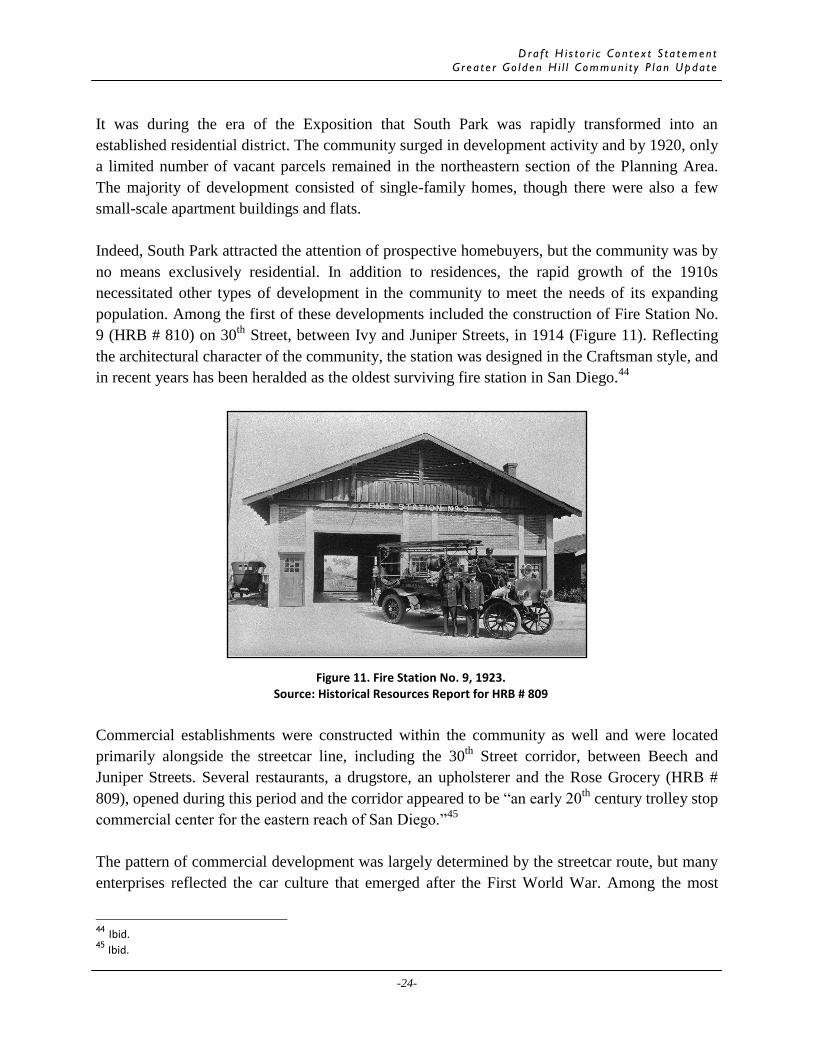
Dra f t H i s t o r i c Co n t e x t S t a t emen t
G r e a t e r Go l d e n H i l l Commun i t y P l a n Upda t e
-24-
It was during the era of the Exposition that South Park was rapidly transformed into an
established residential district. The community surged in development activity and by 1920, only
a limited number of vacant parcels remained in the northeastern section of the Planning Area.
The majority of development consisted of single-family homes, though there were also a few
small-scale apartment buildings and flats.
Indeed, South Park attracted the attention of prospective homebuyers, but the community was by
no means exclusively residential. In addition to residences, the rapid growth of the 1910s
necessitated other types of development in the community to meet the needs of its expanding
population. Among the first of these developments included the construction of Fire Station No.
9 (HRB # 810) on 30th
Street, between Ivy and Juniper Streets, in 1914 (Figure 11). Reflecting
the architectural character of the community, the station was designed in the Craftsman style, and
in recent years has been heralded as the oldest surviving fire station in San Diego.44
Commercial establishments were constructed within the community as well and were located
primarily alongside the streetcar line, including the 30th
Street corridor, between Beech and
Juniper Streets. Several restaurants, a drugstore, an upholsterer and the Rose Grocery (HRB #
809), opened during this period and the corridor appeared to be “an early 20th
century trolley stop
commercial center for the eastern reach of San Diego.”45
The pattern of commercial development was largely determined by the streetcar route, but many
enterprises reflected the car culture that emerged after the First World War. Among the most
44 Ibid. 45
Ibid.
Figure 11. Fire Station No. 9, 1923. Source: Historical Resources Report for HRB # 809

Dra f t H i s t o r i c Co n t e x t S t a t emen t
G r e a t e r Go l d e n H i l l Commun i t y P l a n Upda t e
-25-
commonly built commercial establishments are gasoline and service stations, which were
generally located on the community’s most prominent and accessible corners. The Burlingame
Garage at 2227 30th
Street (HRB # 808) was also designed with the automobile in mind, and for
more than 30 years provided a facility for area residents to store and service their vehicles.46
Though residential development in South Park reached its peak in the years preceding the
Exposition, homes were constructed, albeit more slowly, through the late 1920s. By 1930, only a
handful of parcels in the community remained vacant, and shortly thereafter the northeastern
section of the Planning Area had reached capacity.47
Socially, the neighborhood had remained
the domain of the civic elite, and among its most notable residents included Mayor James
Wadham; master architect Edward Quayle; renowned artist Alfred Mitchell; and notable
businessmen O.W. Cotton and John F. Forward.48
During its formative years, South Park assumed the shape and character of a twentieth century
streetcar suburb. In addition to improving the community’s accessibility and catalyzing
construction, the electric streetcar was ultimately responsible for shaping the pattern of
development within South Park. When the streetcar line was removed in 1949, the general land
development patterns and organization of the community had been established with commercial
establishments located along major transportation routes and residential buildings located within
a close distance of the streetcar.
Property Types
As the streetcar line expanded throughout the Planning Area, residential development flourished.
There was a shift from large, stately homes to modest bungalows, particularly in South Park. In
addition, there was a shift in architectural styles as the Victorian style fell out of favor and period
revival styles became popular. Along with flats and bungalow courts, larger apartment buildings
began to appear in the Planning Area. As the number of Golden Hill residents increased, retail
establishments along with religious institutions opened in the neighborhood. The majority of
commercial properties were located along streetcar lines including 25th
Street. Religious
institutions were scattered across the neighborhood; one of the earliest was the Swedish Lutheran
Church located on the northeast corner of 25th
and E Street.
Residential
Residential development during the streetcar development period overlapped with the previous
period (Elite Residential District) and therefore, similar properties can be associated with this
46 Ibid. 47 Montes 48
Ibid.

Dra f t H i s t o r i c Co n t e x t S t a t emen t
G r e a t e r Go l d e n H i l l Commun i t y P l a n Upda t e
-26-
theme. However, rather than large, elaborate Victorian homes, modest bungalows in the
Craftsman, Spanish Eclectic, or Mission Revival architectural styles were common. In addition,
multi-family buildings such as flats were constructed and provided housing options for the City’s
growing middle class. As the population of the City increased and more visitors arrived in the
San Diego for the 1915 Exposition, additional forms of housing such as apartment buildings
began to appear in Golden Hill and other neighborhoods adjacent to Balboa Park. The grid
based street system remained and influenced the setback and location of homes on lots; typically
homes were setback further on the lot than a commercial structure.
Single Family Homes
The most prevalent property constructed during the streetcar suburb period was the single family
home. Early homes (those constructed prior to 1915) were generally large, two-stories, and
designed in Craftsman, Prairie, Mission Revival, or Spanish Eclectic architectural styles (Figure
12). Modest homes built throughout this period were often one story, and reflected the same
architectural styles. By the early 20th
century, there was a noticeable shift away from Victorian
Era styles to styles influenced by the Arts and Crafts Movement such as Craftsman Bungalows
or homes that incorporated two or more styles such as Prairie and Craftsman. Many Craftsman
homes were set back from the street, featured large front porches, gable roofs, exposed rafter
tails, decorative beams or brackets, and wood lap or shingle siding. Prairie homes featured low-
pitched or flat roofs, prominent front or side porches, wide over-hanging eaves, and often
incorporated both stucco and wood in their exterior finishes. Mission Revival homes featured a
flat or gable roof with Mission style parapet, wide over-hanging eaves, smooth stucco, and a
front or side porch. Common features of Spanish Eclectic homes included low-pitched gable
roofs with red tile, narrow eaves, smooth stucco facades, arched windows or doors along the
principal façade.
Figure 12. E.E. Leighninger House, HRB #584, 1611 Dale Street. Source: CPCI Staff

Dra f t H i s t o r i c Co n t e x t S t a t emen t
G r e a t e r Go l d e n H i l l Commun i t y P l a n Upda t e
-27-
Character-Defining Features
Single family homes in Greater Golden Hill constructed during the development of the area as a
streetcar community feature the following character-defining features:
One or two-stories
Craftsman, Prairie, Mission Revival, or Spanish Eclectic architectural styles
Wood-frame construction
Gable , hip or flat roof
Stucco or wood cladding
Wood-sash windows (typically double hung) or casement windows
Wood door (glazed or paneled)
Prominent front or side porches
Flats
Between 1906 and 1920, several flats were constructed in the southern and western section of
Golden Hill. These flats were generally located south of “A” Street and west of 27th
Street.
Many of these flats are still extant and represent another residential building type common to the
Planning Area. Unlike apartment buildings – which generally feature shared entryways and
corridors – each unit in a residential flat is accessed by an independent entrance.49
Flats generally
contain between two and four independent units and are designed in either the Victorian,
Craftsman, Prairie or period revival styles (Figures 13 and 14).
49 Roland-Nawi Associates, Mission Dolores Historic Context Statement (Sacramento: December 2007), 37-38.
Figure 13. Flats at 1228-34 24th
Street. Source: CPCI Staff
Figure 14. Flats at 1077 26th
Street. Source: CPCI Staff

Dra f t H i s t o r i c Co n t e x t S t a t emen t
G r e a t e r Go l d e n H i l l Commun i t y P l a n Upda t e
-28-
Character-Defining Features
Flats in Greater Golden Hill constructed during the development of the area as a streetcar
community feature the following character-defining features:
One or two-stories
Craftsman, Prairie, Colonial Revival, or other period revival styles
Stucco or wood cladding
Gable, hip or flat roof
Wood door (glazed or paneled)
Typically each unit accessed by an independent entrance
Apartment Buildings
Moderate-scale apartment buildings first appeared in Golden Hill in the early 20th
Century.
These structures, which contain more units than residential flats, are typically multistoried,
occupy prominent corner lots and feature characteristics of Prairie or period revival style
architecture (Figure 15). For many years, properties in South Park were accompanied by
restrictive covenants that prohibited the construction of multifamily housing; therefore, early
apartment buildings are primarily concentrated south of “A” Street in Golden Hill.
Figure 15. Golden View Apartments at 23rd
and “E” Streets. HRB #193
Source: CPCI Staff

Dra f t H i s t o r i c Co n t e x t S t a t emen t
G r e a t e r Go l d e n H i l l Commun i t y P l a n Upda t e
-29-
Character-Defining Features
Apartment buildings in Greater Golden Hill constructed during the development of the area as a
streetcar community feature the following character-defining features:
Multistoried (over 3 stories)
Prairie or Period Revival Styles (Colonial Revival, Neoclassical)
Typically flat roof with parapet and/or mansard roof
Stucco or wood cladding
Normally on prominent corner lots
Wood door (glazed or paneled)
Bungalow Courts
While not as common as other residential property types, several bungalow courts are
interspersed throughout Greater Golden Hill. Bungalow courts were constructed primarily in the
years after World War I and before World War II. These courts were built along the streetcar
transit lines and at the time were thought of as an ideal location for singles, especially single
women working in downtown offices.50
Many were done in the Mediterranean, Mission, Spanish
and Period Revival styles popular at the time. Bungalow courts typically contained between six
and ten units arranged around a landscaped central court or a long garden pathway. The units
were typically small and contained a small kitchen, a bathroom and main room bedroom/living
room sometimes with a pull down bed. The courtyard areas created a community gathering area
and were intended to foster a safe and social environment for those who could not afford a
single family home. After World War II, fewer Bungalow Courts were built as developers
concentrated on single family homes and large apartments. A handful of bungalow courts can be
found in both Golden Hill and South Park, and feature Spanish Eclectic or other period revival
style elements (Figures 16 and 17).
50
James R. Curtis and Larry Ford, “Bungalow Courts in San Diego: Monitoring a Sense of Place,” The Journal of San Diego
History 34 (1988), 2.

Dra f t H i s t o r i c Co n t e x t S t a t emen t
G r e a t e r Go l d e n H i l l Commun i t y P l a n Upda t e
-30-
Character-Defining Features
Bungalow courts in Greater Golden Hill constructed during the streetcar era feature the
following character-defining features:
Attached or detached small cottages arranged around a landscaped central court or a long
garden pathway
Typically single-story
Built along the streetcar transit lines
Mediteranean, Mission, Spanish and Period Revival styles
Wood-frame construction
Gable, hip or flat roof
Stucco or wood cladding
Wood-sash windows (typically double hung)
Wood door (glazed or paneled)
Significance
In order to be eligible for listing in the local, state or national historic register, residential
properties in Golden Hill from the streetcar era must be significant under at least one of the
following criteria.
Figure 16. Bungalow Court at 3137 Juniper Street. Source: CPCI Staff
Figure 17. Bungalow Court at 2412 “E” Street. Source: CPCI Staff

Dra f t H i s t o r i c Co n t e x t S t a t emen t
G r e a t e r Go l d e n H i l l Commun i t y P l a n Upda t e
-31-
NRHP Criterion A/California Register Criterion 1/HRB Criterion B (events)
Residential resources may be significant under NRHP Criterion A/CRHR Criterion 1/HRB
Criterion B for their association with the expansion of Golden Hill as a streetcar suburb. A
residence or group of residences may also be significant under NRHP Criterion A/CRHR
Criterion 1/HRB Criterion B as a representation of Golden Hill as a streetcar suburb.
NRHP Criterion B/California Register Criterion 2/HRB Criterion B (persons)
A residence may be significant under HRB Criterion B for its association with the life of a
person important in the development of Golden Hill as a streetcar suburb. A residential property
that can be documented as the home of an important person in local history such as Mayor James
Wadham; the home of master architect Edward Quayle; renowned artist Alfred Mitchell; and
notable businessmen O.W. Cotton and John F. Forward. Other prominent civic leaders, real
estate developers, or successful businesspersons may also be significant under HRB Criterion B
Documentation must establish the connection between the significant individual and the
resource. In addition, the individual must have lived in the resource during the period that the
person’s significant achievements and contributions occurred.
NRHP Criterion C/California Register Criterion 3/ HRB Criterion C and D (Design/Const.)
A residence may be significant under NRHP Criterion C/California Register Criterion 3/ HRB
Criterion C and D for displaying distinctive characteristics of architectural styles such as
Craftsman, Prairie, Mission Revival, Spanish Eclectic, Colonial Revival or other period
architectural styles. A notable work of a master builder, architect, or designer would be
significant under HRB Criterion D if the residential property was designed or constructed during
the streetcar suburb phase of development in Golden Hill. Established masters with homes in
Golden Hill include Edward Quayle and Irving Gill; however, other master builders, architects,
etc. may be established as further research is conducted.
HRB Criterion A
Residential properties constructed between 1905 and 1930 in Golden Hill may be significant
under HRB Criterion A as a special element of Golden Hill and its development as a streetcar
suburb. These homes would likely be very prominent buildings that were built directly as a
result of the streetcar line or influenced the development of the streetcar. Most likely, if a
property represents a special element of Golden Hill during this period, it will reflect the
historical, cultural, social, economic, political, or architectural development of the community.
Integrity
In order to be eligible for listing in the local, state, or national register, a residential property
from the streetcar era must retain sufficient integrity to convey its significance. A residential

Dra f t H i s t o r i c Co n t e x t S t a t emen t
G r e a t e r Go l d e n H i l l Commun i t y P l a n Upda t e
-32-
property from the streetcar suburb period that has sufficient integrity will retain a majority of the
character-defining features listed above. A property significant under NRHP Criterion A/CRHR
Criterion 1/HRB Criterion B should retain integrity of location, setting, feeling, and association.
A residence significant under NRHP Criterion B/CRHR Criterion 2/HRB Criterion B should
retain integrity of location, design, feeling, and association as the physical fabric that conveys the
connection to the individual is crucial to the property’s significance. A residence significant
under NRHP Criterion C/CRHR Criterion 3/HRB Criterion C or D should retain integrity of
design, materials, workmanship, and feeling as these aspects of integrity are necessary for the
property to convey its significance. Some alterations may be acceptable (replacement of
windows, small addition) as long as the property retains its essential features and overall form. A
property significant under HRB Criterion A should retain integrity of location, setting, design,
feeling, and association.
In evaluating the integrity of properties that date to Golden Hill’s development as a streetcar
suburb, general importance is placed on design, materials, and workmanship through retention of
character defining features of architectural styles. Other aspects of integrity could elevate a
resource to a significant level even if design, materials, and workmanship are diminished. In
these cases, integrity of feeling, association, location, and setting may be of greater importance
than design, materials, and workmanship. This is applicable to properties associated with people
important in the history of Golden Hill or an event that is significant in Golden Hill’s history as a
streetcar suburb. Properties that retain materials and workmanship in addition to design should
be considered individually significant resources.
Commercial
Commercial structures, while not as numerous as residences, can also be found throughout
Greater Golden Hill. While commercial development in the study area consists primarily of
single-story retail structures, a small number of mixed use buildings are also present. Generally,
commercial structures are concentrated in small pockets along 25th
Street in Golden Hill and
along former streetcar routes and stops on 30th
, Beech, and Juniper streets in South Park, though
a few occupy other prominent neighborhood corners. These buildings, like residences, embody a
variety of architectural styles including Mission Revival and Art Moderne.
Single-Story Retail
Single-story retail structures were constructed as the populations of Golden Hill and South Park
grew. Typically, these structures were sited near the street, accommodated a single commercial
tenant and embodied a wide variety of stylistic influences including Mission Revival and
Streamline Moderne (Figures 18 and 19). Some of these structures have since been replaced with
contemporary buildings, but many good examples remain and can be found along major
thoroughfares in both Golden Hill and South Park, particularly along Juniper street, Beech Street,

Dra f t H i s t o r i c Co n t e x t S t a t emen t
G r e a t e r Go l d e n H i l l Commun i t y P l a n Upda t e
-33-
and 25th
Street.
Mixed Use
While common in many older urban neighborhoods, mixed use structures are quite rare in
Greater Golden Hill. Instead of separating residential and commercial uses, mixed use structures
accommodate both property types, most often by combining ground-level retail with upper-story
apartments. In the Planning Area, mixed use structures generally feature between two and three
stories and adhere to a standard “residential-over-commercial” design (Figure 20). Though
uncommon, a handful of these buildings can be found on prominent corner lots throughout the
Planning Area as well as adjacent to the route of the streetcar line.
Character-Defining Features
Commercial properties in Greater Golden Hill constructed during the development of the area as
a streetcar suburb feature the following character-defining features:
Located on corners and along the streetcar transit lines
One or two stories for commercial and retail
Two and three stories for mixed use
Streamline Moderne, Mission, and Spanish styles
Concrete or wood-frame construction
Flat or gable roof with a parapet
Wood or metal storefronts
Built to property line with on street or rear parking
Figure 18. Single-Story Retail at 1138 25th
Street. Source: CPCI Staff
Figure 19. Single-Story Retail at 30th
and Beech Streets. Source: CPCI Staff

Dra f t H i s t o r i c Co n t e x t S t a t emen t
G r e a t e r Go l d e n H i l l Commun i t y P l a n Upda t e
-34-
Significance
In order to be eligible for listing in the local, state or national historic register, commercial
properties from the streetcar era in must be significant under at least one of the following criteria.
NRHP Criterion A/California Register Criterion 1/HRB Criterion B (events)
A commercial building may be significant under NRHP Criterion A/California Register Criterion
1/HRB Criterion B for its association with the development of Golden Hill as a streetcar suburb
or had a significant impact on local history. A commercial building may also be significant under
NRHP Criterion A/CRHR Criterion 1/HRB Criterion B as a representation of the areas streetcar
suburb development during the period.
NRHP Criterion B/California Register Criterion 2/HRB Criterion B (persons)
A commercial building that can be documented as being associated with a prominent civic
leader, real estate developer, or successful businessperson would be significant under NRHP
Criterion B/California Register Criterion 2/HRB Criterion B. In addition, the individual must
have been associated with the resource during the period that the person’s significant
achievements and contributions occurred.
NRHP Criterion C/California Register Criterion 3/ HRB Criterion C and D (Design/Const.)
A commercial resource dating to the streetcar suburb era may be significant under NRHP
Criterion C/California Register Criterion 3/ HRB Criterion C and as an example of a building
type, period or method of construction, or for displaying distinctive characteristics of
architectural styles such as Streamline Moderne, Mission, and Spanish or other period
architectural styles. A notable work of a master builder, architect, or designer would be
significant under HRB Criterion D if the residential property was designed or constructed during
the streetcar suburb phase of development in Golden Hill.
HRB Criterion A
A commercial building may be significant under HRB Criterion A for its association with the
development of Golden Hill as a streetcar suburb. Most likely, if a property represents a special
element of Golden Hill during this period, it will reflect the historical, cultural, social, economic,
political, or architectural development of the community.
Integrity
In order to be eligible for listing in the local, state, or national register, a commercial property
from the streetcar suburb period must retain sufficient integrity to convey its significance. A
commercial property from the streetcar suburb period that has sufficient integrity will retain a
majority of the character-defining features listed above. A property significant under NRHP
Criterion A/CRHR Criterion 1/HRB Criterion B should retain integrity of location, setting,

Dra f t H i s t o r i c Co n t e x t S t a t emen t
G r e a t e r Go l d e n H i l l Commun i t y P l a n Upda t e
-35-
feeling, and association. A commercial building eligible under NRHP Criterion B/CRHR
Criterion 2/HRB Criterion B should retain integrity of location, design, feeling, and association
as the physical fabric that conveys the connection to the individual is crucial to the property’s
significance. A commercial building eligible under NRHP Criterion C/CRHR Criterion 3/HRB
Criterion C or D should retain integrity of design, materials, workmanship, and feeling as these
aspects of integrity are necessary for the property to convey its significance. Some alterations
may be acceptable as long as the property retains its essential features and overall form. A
property significant under HRB Criterion A should retain integrity of location, setting, design,
feeling, and association.
Institutional
Given its residential character, Golden Hill does not contain many institutional or government
structures. By the early 20th
Century, as the community grew there was a need for various civic,
social and recreational buildings and sites. Essential neighborhood facilities such as fire stations
were constructed as early as 1914. However, other facilities such as a post office did not open
until the mid-20th
Century.
Fire Station No. 9 was one of the first institutional buildings constructed in Golden Hill in 1914.
Located on 30th
Street, between Ivy and Juniper Streets, adjacent to the expanding streetcar, Fire
Station No. 9 was built in the Craftsman style. By 1920 another fire station was built on the
southeast corner of 25th
Street and Broadway.
By 1920, the Brooklyn Public School occupied the block bounded by Ash Street, Fern St, A
Street, and 30th Street. A school remains on this site today; however, it is unknown if any
portions of the structure date to the early 20th Century.
Several churches and religious structures, which provide a visual counterpoint to the
community’s residential and commercial fabric, were constructed prior to 1920. Most often,
churches occupy corner lots along major thoroughfares, and can be found interspersed among
both residential and commercial structures (Figure 21). Three of the earliest churches included
the Church of Our Lady of Angels at 24th
and G Street, the Brooklyn Heights Presbyterian
Church at 30th
and Fir, and the Swedish Lutheran Church at 25th
and E Streets.

Dra f t H i s t o r i c Co n t e x t S t a t emen t
G r e a t e r Go l d e n H i l l Commun i t y P l a n Upda t e
-36-
Character-Defining Features
Institutional properties in Greater Golden Hill constructed during the a streetcar era exhibit the
following character-defining features:
Located on prominent corners and along the streetcar transit lines
Typically one or two stories for schools and fire stations
Multiple stories stories for churches and religious structures
Art Moderne, Mission, and Spanish styles
Concrete or wood-frame construction
Gable or flat roof with a parapet
Built to property line with on street or rear parking
Significance
In order to be eligible for listing in the local, state or national historic register, institutional
properties in Golden Hill from the streetcar era must be significant under at least one of the
following criteria.
NRHP Criterion A/California Register Criterion 1/HRB Criterion B (events)
Institutional resources may be significant under NRHP Criterion A/CRHR Criterion 1/HRB
Criterion B as a representation of the development of Golden Hill as a streetcar suburb. If the
institutional property played an important role in the history or development of Golden Hill it
may be significant under NRHP Criterion A/CRHR Criterion 1/HRB Criterion B.
Figure 21. Church at 835 25th
Street. Source: CPCI Staff
Dra f t H i s t o r i c Co n t e x t S t a t emen t
G r e a t e r Go l d e n H i l l Commun i t y P l a n Upda t e
-37-
NRHP Criterion B/California Register Criterion 2/HRB Criterion B (persons)
An institutional building may be significant under NRHP Criterion B/California Register
Criterion 2/HRB Criterion B for its association with the life of a person important in the
development of Golden Hill as a streetcar suburb. An institutional property that can be
documented as associated with an important person in local history such as a prominent civic
leader, real estate developer, successful businessperson, or clergy may be significant.
NRHP Criterion C/California Register Criterion 3/ HRB Criterion C and D (Design/Const.)
An institutional building may be eligible under NRHP Criterion C/California Register Criterion
3/ HRB Criterion C and D for embodying distinctive characteristics of a style, type, period, or
method of construction. Institutional buildings were designed in a variety of architectural styles,
but some of the favored styles include Streamline Moderne, Mission, and Spanish styles. A
notable work of a master builder, architect, or designer may be significant under HRB Criterion
D if the property was designed or constructed during the streetcar era in Golden Hill.
HRB Criterion A
An institutional building dating to the streetcar era may be eligible under HRB Criterion A as a
special element of the development of Golden Hill. Most likely, if an institutional property
represents a special element of Golden Hill during this period, it will reflect the historical,
cultural, social, economic, political, or architectural development of the community.
Integrity
In order to be eligible for listing in the local, state, or national register, an institutional property
from the streetcar suburb period must retain sufficient integrity to convey its significance. An
institutional property from the streetcar suburb period that has sufficient integrity will retain a
majority of the character-defining features listed above. A property significant under NRHP
Criterion A/CRHR Criterion 1/HRB Criterion B should retain integrity of location, setting,
feeling, and association. An institutional property significant under NRHP Criterion B/CRHR
Criterion 2/HRB Criterion B should retain integrity of location, design, feeling, and association
as the physical fabric that conveys the connection to the individual is crucial to the property’s
significance. An institutional property significant under NRHP Criterion C/CRHR Criterion
3/HRB Criterion C or D should retain integrity of design, materials, workmanship, and feeling as
these aspects of integrity are necessary for the property to convey its significance. Some
alterations may be acceptable as long as the property retains its essential features and overall
form. A property significant under HRB Criterion A should retain integrity of location, setting,
design, feeling, and association.

Dra f t H i s t o r i c Co n t e x t S t a t emen t
G r e a t e r Go l d e n H i l l Commun i t y P l a n Upda t e
-38-
D. AN ERA OF TRANSITIONS: 1930-1990
Note: Additional research and fieldwork will need to be conducted to complete this section. In
particular, more information is required on the influence of Union Halls in Golden Hill.
The Great Depression and World War II:
Although Greater Golden Hill was among San Diego’s most affluent districts by the late 1920s,
the community was nonetheless impacted by the onset of the Great Depression. Between the
years 1929 and 1932, the national rate of home construction decreased by nearly 80 percent, and
in effect the Planning Area, which was primarily residential, experienced very little development
activity over the course of the 1930s.51
Among the handful of new structures erected in the
Depression Era was the Seventh Day Adventist Church at 2411 Broadway, an intact example of
the Art Deco style (Figure 22).52
A residential security map of San Diego, created by the Home Owners Loan Corporation
(HOLC) in 1933, indicates that the Planning Area began to witness physical decline as early as
the Depression era. To determine which urban neighborhoods qualified for federal mortgage
51 Mark Broad, “I Remember the Wall Street Crash,” BBC News, 6 Oct. 2008. 52
City of San Diego, “Greater Golden Hill Historic District.”
Figure 22. Seventh Day Adventist Church, HRB #130 Source: Historical Resources Report for HRB # 130

Dra f t H i s t o r i c Co n t e x t S t a t emen t
G r e a t e r Go l d e n H i l l Commun i t y P l a n Upda t e
-39-
assistance, the HOLC devised a four-tiered appraisal system, wherein residential districts were
rated on a scale of 1 to 4 (Figure 23).53
The map indicates that central Golden Hill was among
the lowest stratum, or “fourth grade,” of neighborhoods, which was suggestive of poor
maintenance, physical distress and vandalism.54
Most of South Park received a “third grade”
rating, given the relative age and condition of its housing stock.
The next wave of activity within Greater Golden Hill was touched off by the Second World War,
at which time San Diego was transformed into a thriving metropolitan center. Shortly after the
war began in 1939, the Federal Government invested heavily in defense, and San Diego, which
was home to both a sizable naval presence and aviation contractor Consolidated Aircraft,
emerged as a hub of wartime production. This culminated in a period of rapid population growth
between the years 1940 and 1943, wherein defense employees and their families poured into the
city at an average of 1,500 per week.55
53 Becky M. Nicolaides and Andrew Wiese, The Suburb Reader (New York: Routledge), 2006, 248. 54
Ibid. 55
Christine Killory, “Temporary Suburbs: The Lost Opportunity of San Diego’s National Defense Housing Projects,” The
Journal of San Diego History 39 (1993), 1-2.
Figure 23. HOLC Residential Security map of San Diego, 1933. Source: David Theo Goldberg and Richard Marciano

Dra f t H i s t o r i c Co n t e x t S t a t emen t
G r e a t e r Go l d e n H i l l Commun i t y P l a n Upda t e
-40-
Not surprisingly, the massive influx of war workers strained San Diego’s resources and
infrastructure, and the city thereafter experienced a housing shortage unparalleled in its history.56
Indeed, the Federal Government provided some relief by constructing workforce housing for
defense employees, but much of the problem remained on the shoulders of local officials.
Among the remedies adopted by the City Council was to amend the municipal zoning code, so
that density would be encouraged in several areas throughout the city, including much of Greater
Golden Hill.57
Postwar Aftermath: Physical and Social Change:
Due to the amended zoning ordinance, much of Greater Golden Hill experienced marked
physical changes both during and after World War II. Development in the area – especially south
of “A” Street – picked up once again during the 1940s and 1950s, but unlike previous years, new
construction of this era consisted primarily of moderate and large-scale apartment complexes.58
Indeed, some of these apartments were sited on vacant parcels, but others replaced many of the
neighborhood’s single-family residences.59
By 1956, a substantial number of homes south of “A” Street had either been subdivided or
converted for alternative uses. Hebbard and Gill’s A.H. Frost House at 2456 Broadway (HRB #
130), as well as Gill’s George Garrettson House at 2411 “E” Street (HRB # 130), were initially
constructed as single-family residences, but by 1956 were used as rest homes.60
Other residences,
including those at 931 22nd
Street, 1030 24th
Street and 2451 “B” Street, were converted into
rooming houses and apartment flats, and a home at 1260 22nd
Street had become the Laynes
Hospitality Home for Servicemen.
Undoubtedly, the abundance of apartments and rooming houses within Golden Hill brought a
sizable number of the working class to the neighborhood. This shift in demography is seen in the
increase of several union halls and labor centers.61
Among these facilities included the American
Federation of Labor Building at 23rd
and Broadway; the Frank Rosenbloom Labor Center at 1165
19th
Street; and a complex of union offices at 2731 “B” Street.
Further physical change came about in the late 1950s, when the State Division of Highways
initiated the construction of two freeways – Interstate 5 and State Route 94 – along the Planning
Area’s southern and western borders. As these routes were intended to convenience suburban
commuters, little effort was made to mitigate their impacts on Golden Hill, and in turn several
56
Ibid. 57
Greater Golden Hill Planning Committee and City of San Diego Planning Department, 6. 58 Ibid. 59
Sanborn Maps, 1920 and 1956. 60
Sanborn Maps, 1956 61
Ibid.

Dra f t H i s t o r i c Co n t e x t S t a t emen t
G r e a t e r Go l d e n H i l l Commun i t y P l a n Upda t e
-41-
homes that obstructed the freeways’ paths were razed. Freeway construction also had the effect
of “carving out” and isolating Golden Hill, as many streets were truncated and re-routed to
accommodate underpasses, overpasses and ramps.62
Whereas central Golden Hill was markedly redeveloped during and after World War II, the
northeastern section of the Planning Area experienced comparatively little physical change
during this time. By the late 1940s, San Diego’s electric streetcars had been decommissioned and
their tracks removed, yet in subsequent years South Park retained the form and character of a
streetcar suburb.63
During this period, most of South Park’s homes and businesses remained
intact, and little infill development had occurred.64
A Diverse Neighborhood Emerges
Between the 1960s and 1970s, Greater Golden Hill witnessed marked changes in its
demographic makeup. The availability of affordable apartments, in conjunction with the exodus
of middle and upper class homeowners to the suburbs, meant that the once-exclusive community
attracted an increasing number of working class.65
In time, central Golden Hill emerged as one of
San Diego’s most ethnically and economically diverse neighborhoods.66
At this time, the majority of incoming residents rented instead of owned their homes. Due to
absentee landlords, little maintenance was completed on the neighborhood’s aging structures and
the condition of many structures deteriorated.67
An article in the Los Angeles Times described
Golden Hill as a community replete with “rickety, dilapidated homes interspersed among the
mansions for which the area is noted.”68
Interest in Greater Golden Hill was regenerated in the 1970s, when two national oil crises steered
many middle-class professionals back into centralized, inner-city neighborhoods.69
As
homeownership in the Planning Area steadily increased throughout the 1980s, there emerged a
growing consciousness among residents to eradicate blight, reduce density and restore the
community’s historic character. In 1978, the City’s Historical Resources Board designated the
Golden Hill Historic District, a six block area bounded by Balboa Park on the north, 25th
Street
on the east, F Street on the south, and 24th
Street on the west. Following the designation of the
district, there was a concerted effort by property owners and community members to preserve
62
Betty Slater, “A New Era for Golden Hill,” San Diego Home and Garden, July 1980, 33. 63
Montes. 64
Sanborn Maps, 1956 65
Greater Golden Hill Planning Committee and City of San Diego Planning Department, 6. 66
Robert Montemayor, “Energy and Vision Bring Glitter Back Into Golden Hill,” Los Angeles Times, May 16, 1982. 67
Slater, 34. 68
Montemayor. 69
Ibid.

Dra f t H i s t o r i c Co n t e x t S t a t emen t
G r e a t e r Go l d e n H i l l Commun i t y P l a n Upda t e
-42-
and embrace the heritage and built environment in Golden Hill.
Property Types
Though Golden Hill was primarily built out by the start of World War II, a few residential and
commercial property types emerged from the pre and post-war era. San Diego emerged as a
center for the Navy and much of the City experienced a build up prior to the War. A period of
rapid population growth between 1940 and 1943 left the City with a housing shortage. The City
Council responded by amending the municipal housing code, so that density would be
encouraged. This resulted in larger apartment buildings being constructed in several areas
throughout the City including Golden Hill. In addition, as San Diego emerged as the center for
Naval activity in the Pacific, other wartime industries such as aviation and shipbuilding
established factories and offices in the City. This created an influx of workers seeking jobs and
in response, the popularity of labor unions increased and the union presence was visible in San
Diego, particularly in Golden Hill.
Residential
Given that the Planning Area was built out by the 1930s, and mid-century zoning codes
encouraged high density residential development, few, if any single family homes were
constructed in Greater Golden Hill after the Great Depression. Multi-family housing in the form
of apartment buildings were constructed in this period. In addition, large single family homes
were converted into multiple units and rented to residents rather than owner occupied.
Apartment Buildings
Due to amendments to the municipal zoning code, large apartment buildings constructed after the
Second World War were generally concentrated in the area south of A Street. These apartments
are considerably larger than those constructed in previous years contained more units, and were
oriented around the automobile. Generally, these postwar structures are between two and four
stories, embody contemporary architectural styles, and are located in the southern and western
sections of the study area (Figure 24).
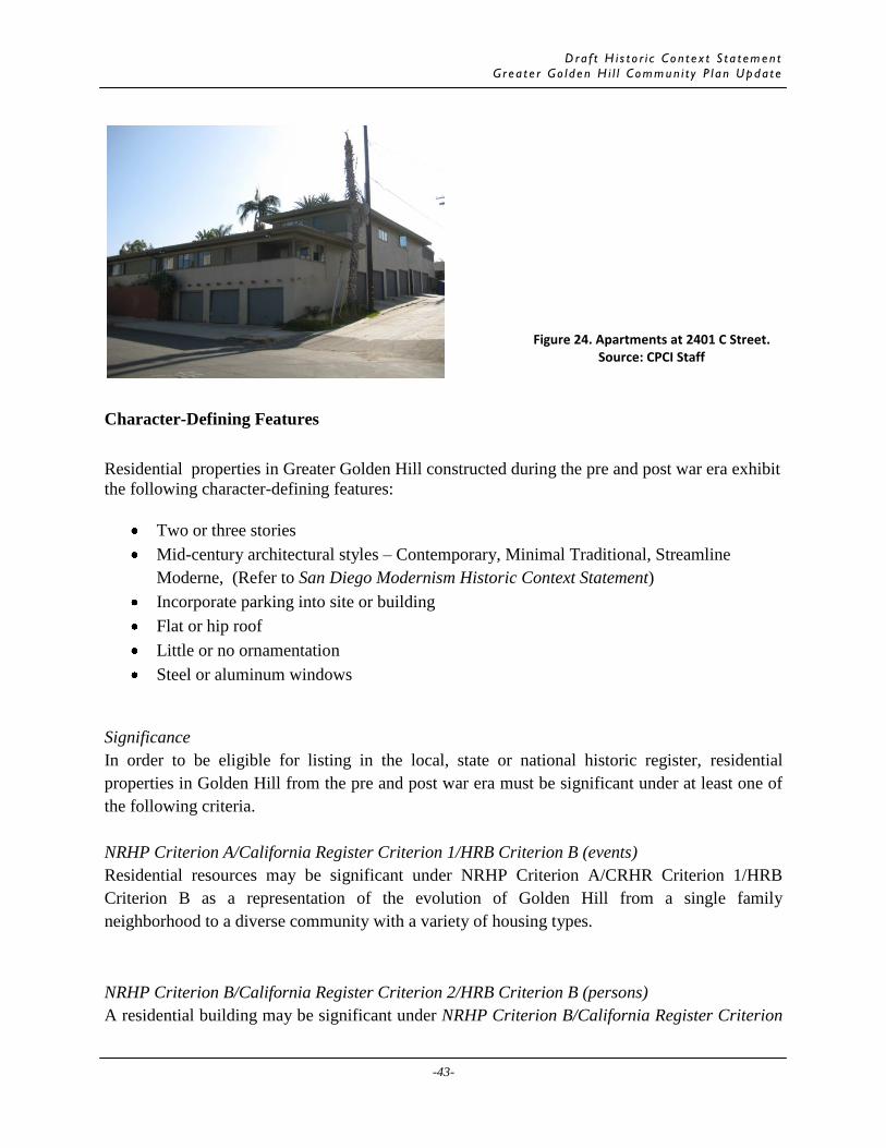
Dra f t H i s t o r i c Co n t e x t S t a t emen t
G r e a t e r Go l d e n H i l l Commun i t y P l a n Upda t e
-43-
Character-Defining Features
Residential properties in Greater Golden Hill constructed during the pre and post war era exhibit
the following character-defining features:
Two or three stories
Mid-century architectural styles – Contemporary, Minimal Traditional, Streamline
Moderne, (Refer to San Diego Modernism Historic Context Statement)
Incorporate parking into site or building
Flat or hip roof
Little or no ornamentation
Steel or aluminum windows
Significance
In order to be eligible for listing in the local, state or national historic register, residential
properties in Golden Hill from the pre and post war era must be significant under at least one of
the following criteria.
NRHP Criterion A/California Register Criterion 1/HRB Criterion B (events)
Residential resources may be significant under NRHP Criterion A/CRHR Criterion 1/HRB
Criterion B as a representation of the evolution of Golden Hill from a single family
neighborhood to a diverse community with a variety of housing types.
NRHP Criterion B/California Register Criterion 2/HRB Criterion B (persons)
A residential building may be significant under NRHP Criterion B/California Register Criterion
Figure 24. Apartments at 2401 C Street. Source: CPCI Staff

Dra f t H i s t o r i c Co n t e x t S t a t emen t
G r e a t e r Go l d e n H i l l Commun i t y P l a n Upda t e
-44-
2/HRB Criterion B for its association with the life of a person important in the development of
Golden Hill during the pre or post war era. A residential property that can be documented as
associated with an important person in local history such as a prominent civic leader, union
organizer, or someone who made significant contributions to the defense industry in San Diego
may qualify for designation.
NRHP Criterion C/California Register Criterion 3/ HRB Criterion C and D (Design/Const.)
A residential building dating to the pre and posts war era may be eligible under NRHP Criterion
C/California Register Criterion 3/ HRB Criterion C and D for embodying distinctive
characteristics of a style, type, period, or method of construction A notable work of a master
builder, architect, or designer may be significant under HRB Criterion D. These resources
should be evaluated in context of both Golden Hill’s history and the City’s Modernism historic
Context Statement.
HRB Criterion A
A residential building dating to the pre and post war era may be eligible under HRB Criterion A
as a special element of the development of Golden Hill. If the property contributed to the growth
and expansion of Golden Hill as a diverse community both in terms of its demographics or
housing types it may be eligible under HRB Criterion A.
Integrity
In order to be eligible for listing in the local, state, or national register, a residential property
from the pre and post war period must retain sufficient integrity to convey its significance. A
residential property that has sufficient integrity will retain a majority of the character-defining
features listed above. A property significant under NRHP Criterion A/CRHR Criterion 1/HRB
Criterion B should retain integrity of location, setting, feeling, and association. A residential
property significant under NRHP Criterion B/CRHR Criterion 2/HRB Criterion B should retain
integrity of location, design, feeling, and association as the physical fabric that conveys the
connection to the individual is crucial to the property’s significance. A residential property
significant under NRHP Criterion C/CRHR Criterion 3/HRB Criterion C or D should retain
integrity of design, materials, workmanship, and feeling as these aspects of integrity are
necessary for the property to convey its significance. A property significant under HRB
Criterion A should retain integrity of location, setting, design, feeling, and association. In
evaluating the integrity of properties that date to Golden Hill’s development during the pre and
post war era, consideration of integrity thresholds established in the City’s Modernism Historic
Context Statement should be applied as most likely resources will reflect architectural styles
included in the Context Statement.

Dra f t H i s t o r i c Co n t e x t S t a t emen t
G r e a t e r Go l d e n H i l l Commun i t y P l a n Upda t e
-45-
Commercial
Historically, the communities of Golden Hill and South Park were marketed as high-class
residential districts and were not associated with commercial uses. A limited number of
commercial establishments were constructed in the Golden Hill during its development as a
streetcar suburb. During the pre and post war era, the majority of commercial properties
included gasoline stations, automotive repair shops and small manufacturer establishments.
These buildings generally feature flat roofs and vehicular bays, are between one and two stories,
and are sited among other commercial developments along former streetcar lines (Figure 25).
Most often, they embody a variety of architectural styles, but are ornamentally restrained.
Character-Defining Features
Commercial properties in Greater Golden Hill constructed during the pre and post war era
exhibit the following character-defining features:
One story
Oriented towards automobile services
Canopy Overhangs
Flat roofs
Located along 25th
Street, Juniper Street, and 30th
Street
Significance
In order to be eligible for listing in the local, state or national historic register, commercial
properties in Golden Hill from the pre and post war era must be significant under at least one of
the following criteria.
Figure 25. Gasoline Station at 25th
and C Street. Source: CPCI Staff

Dra f t H i s t o r i c Co n t e x t S t a t emen t
G r e a t e r Go l d e n H i l l Commun i t y P l a n Upda t e
-46-
NRHP Criterion A/California Register Criterion 1/HRB Criterion B (events)
It is not likely that commercial resources will be significant under NRHP Criterion A/CRHR
Criterion 1/HRB Criterion B as a representation of the evolution of Golden Hill from a single
family neighborhood to a diverse community with a variety of housing types. With a limited
number of commercial properties built during this period, it is unlikely that they will represent
this theme.
NRHP Criterion B/California Register Criterion 2/HRB Criterion B (persons)
Due to the limited number of commercial resources built during the pre and post war era, it is not
likely that a commercial building will be significant under NRHP Criterion B/California Register
Criterion 2/HRB Criterion B for its association with the life of a person important during this
period. However, it may be possible through additional research that a connection between a
significant individual and an individual resource may be made; it these cases these resources may
be significant under NRHP Criterion B/California Register Criterion 2/HRB Criterion B.
NRHP Criterion C/California Register Criterion 3/ HRB Criterion C and D (Design/Const.)
A commercial building dating to the pre and posts war era may be eligible under NRHP
Criterion C/California Register Criterion 3/ HRB Criterion C and D for embodying distinctive
characteristics of a style, type, period, or method of construction. It is not likely that a building
will be a notable work of a master builder, architect, or designer due to the limited number of
commercial resources constructed during this period. All resources should be evaluated in
context of both Golden Hill’s history and the City’s Modernism historic Context Statement.
HRB Criterion A
A commercial building dating to the pre and post war era may be eligible under HRB Criterion A
as a special element of the development of Golden Hill as a representation of the evolution of the
community of a single family neighborhood to a diverse community. However, it is not likely
that there are a large number of commercial properties that reflect this evolution as this change is
best exemplified through residential and institutional properties.
Integrity
In order to be eligible for listing in the local, state, or national register, a commercial property
from the pre and post war period must retain sufficient integrity to convey its significance. A
commercial property that has sufficient integrity will retain a majority of the character-defining
features listed above. A property significant under NRHP Criterion A/CRHR Criterion 1/HRB
Criterion B should retain integrity of location, setting, feeling, and association. A commercial
property significant under NRHP Criterion B/CRHR Criterion 2/HRB Criterion B should retain
integrity of location, design, feeling, and association as the physical fabric that conveys the
connection to the individual is crucial to the property’s significance. A commercial property
significant under NRHP Criterion C/CRHR Criterion 3/HRB Criterion C or D should retain

Dra f t H i s t o r i c Co n t e x t S t a t emen t
G r e a t e r Go l d e n H i l l Commun i t y P l a n Upda t e
-47-
integrity of design, materials, workmanship, and feeling as these aspects of integrity are
necessary for the property to convey its significance. A property significant under HRB
Criterion A should retain integrity of location, setting, design, feeling, and association. In
evaluating the integrity of properties that date to Golden Hill’s development during the pre and
post war era, consideration of integrity thresholds established in the City’s Modernism Historic
Context Statement should be applied as most likely resources will reflect architectural styles
included in the Context Statement.
Institutional (Additional research/fieldwork required)
A number of institutional buildings including union halls and auditoriums were constructed
during the pre and post war period. Generally constructed between 1945 and 1960, these large
buildings were typically one or two stories in heights and featured little ornamentation; though
some reflected Streamline Moderne architecture such as the AFL building at 23rd and Broadway
(Figure 26). Often constructed of poured concrete or concrete block, these buildings typically
had restrained ornamentation if any, and some were utilitarian in nature. The majority of these
buildings appear to be located south of A Street.
Character-Defining Features
Institutional properties in Greater Golden Hill constructed during the pre and post war era
exhibit the following character-defining features:
Figure 26. American Federation of Labor Building at 2323 Broadway. Source: CPCI Staff

Dra f t H i s t o r i c Co n t e x t S t a t emen t
G r e a t e r Go l d e n H i l l Commun i t y P l a n Upda t e
-48-
Originally functioned as union hall
Two or three stories
Mid-century architectural style – Streamline Moderne, International, Contemporary
(Refer to San Diego Modernism Historic Context Statement)
Flat, barrel or hip roof
Little or no ornamentation
Steel or aluminum windows
Significance
In order to be eligible for listing in the local, state or national historic register, institutional
properties in Golden Hill from the pre and post war era must be significant under at least one of
the following criteria.
NRHP Criterion A/California Register Criterion 1/HRB Criterion B (events)
Institutional resources may be significant under NRHP Criterion A/CRHR Criterion 1/HRB
Criterion B as a representation of the evolution of Golden Hill from a single family
neighborhood to a diverse community. For example, a union hall may reflect the increase in the
number of working class moving into Golden Hill.
NRHP Criterion B/California Register Criterion 2/HRB Criterion B (persons)
An institutional building may be significant under NRHP Criterion B/California Register
Criterion 2/HRB Criterion B for its association with the life of a person important in the
development of Golden Hill during the pre or post war era. For example, if a particular property
is associated with an important union organizer, it may be significant.
NRHP Criterion C/California Register Criterion 3/ HRB Criterion C and D (Design/Const.)
An institutional building dating to the pre and posts war era may be eligible under NRHP
Criterion C/California Register Criterion 3/ HRB Criterion C and D for embodying distinctive
characteristics of a style, type, period, or method of construction A notable work of a master
builder, architect, or designer may be significant under HRB Criterion D. These resources
should be evaluated in context of both Golden Hill’s history and the City’s Modernism historic
Context Statement.
HRB Criterion A
An institutional building dating to the pre and post war era may be eligible under HRB Criterion
A as a special element of the development of Golden Hill. Most likely, if a property represents a
special element of Golden Hill during the pre and post war era, it will reflect the historical,
cultural, economic, or political development of the community.

Dra f t H i s t o r i c Co n t e x t S t a t emen t
G r e a t e r Go l d e n H i l l Commun i t y P l a n Upda t e
-49-
Integrity
In order to be eligible for listing in the local, state, or national register, an institutional property
from the pre and post war period must retain sufficient integrity to convey its significance. An
institutional property that has sufficient integrity will retain a majority of the character-defining
features listed above. A property significant under NRHP Criterion A/CRHR Criterion 1/HRB
Criterion B should retain integrity of location, setting, feeling, and association. An institutional
property significant under NRHP Criterion B/CRHR Criterion 2/HRB Criterion B should retain
integrity of location, design, feeling, and association as the physical fabric that conveys the
connection to the individual is crucial to the property’s significance. A property significant
under NRHP Criterion C/CRHR Criterion 3/HRB Criterion C or D should retain integrity of
design, materials, workmanship, and feeling as these aspects of integrity are necessary for the
property to convey its significance. A property significant under HRB Criterion A should retain
integrity of location, setting, design, feeling, and association. In evaluating the integrity of
properties that date to Golden Hill’s development during the pre and post war era, consideration
of integrity thresholds established in the City’s Modernism Historic Context Statement should be
applied as most likely resources will reflect architectural styles included in the Context
Statement.

Dra f t H i s t o r i c Co n t e x t S t a t emen t
G r e a t e r Go l d e n H i l l Commun i t y P l a n Upda t e
-50-
BIBLIOGRAPHY
“Best Residence Section in City: South Park Offers Every Inducement to the Home Builder.”
San Diego
Union, December 1906.
Broad, Mark. “I Remember the Wall Street Crash.” BBC News, October 6, 2008.
Carrico, Susan Hunter. Urban Indians in San Diego: 1850-1900. M.A. Thesis, University of San
Diego,
1984.
City of San Diego. Historical Resources Board. “Greater Golden Hill Historic District.”
Historical
Resources Report, 1970.
City of San Diego. Historical Resources Board. “Laura M. and James R. Luttrell House.”
Historical
Resources Report. 2007.
City of San Diego. Historical Resources Board. “Rose Grocery.” Historical Resources Report,
2007.
Crane, Clare. “Withering Heights: Golden Hill Where the Power Was.” San Diego Magazine,
March 1971.
Curtis, James R., and Larry Ford. “Bungalow Courts in San Diego: Monitoring a Sense of
Place.” The
Journal of San Diego History 34 (1988), 2.
Davidson, John. “Golden Hill Recalled as Ugly Indian Camp.” San Diego Union, July 2, 1937.
Goldberg, David Theo, and Richard Marciano. “T-Races: A Testbed for the Redlining Archives
of
California’s Exclusionary Spaces.” Vectors Journal of Culture and Technology in a
Dynamic Vernacular. http://www.vectorsjournal.net/projects/index.php?project=93
(accessed April 30, 2009).

Dra f t H i s t o r i c Co n t e x t S t a t emen t
G r e a t e r Go l d e n H i l l Commun i t y P l a n Upda t e
-51-
Greater Golden Hill Planning Committee, and City of San Diego Planning Department. Golden
Hill
Community Plan. 1988.
Killory, Christine. “Temporary Suburbs: The Lost Opportunity of San Diego’s National Defense
Housing
Projects.” The Journal of San Diego History 39 (1993), 1-2.
McWilliams, Carey. Southern California: An Island on the Land. Salt Lake City: Peregrine
Smith, 1973.
Montemayor, Robert. “Energy and Vision Bring Glitter Back Into Golden Hill.” Los Angeles
Times, May
16, 1982.
Montes, Beth. “The Early History of South Park.” Unpublished paper.
http://www.southparkneighbors.com/index.php?pageId=93390 (accessed 16 March
2009).
Montes, Gregory E. “San Diego’s City Park, 1868-1902: An Early Debate on Environment and
Profit.”
The Journal of San Diego History 23 (1977), 2.
Nicolaides, Becky M., and Andrew Wiese, eds. The Suburb Reader. New York: Routledge,
2006.
Pourade, Richard F. Gold in the Sun. San Diego: Copley Press, 1965.
Pourade, Richard F. The Explorers. San Diego: Union-Tribune Publishing Company, 1960.
Roland-Nawi Associates. Mission Dolores Historic Context Statement. December, 2007.
Roth, Leland M. American Architecture. Boulder: Westview Press, 2003.
Sanborn Fire Insurance Company Maps. San Diego, California.
Slater, Betty. “A New Era for Golden Hill.” San Diego Home and Garden, July 1980.
Smythe, William Ellsworth. History of San Diego 1542-1908. San Diego: The History Company,
1908.

Greater Golden Hill Community Plan Area Appendix B-1 Historic Resources Survey
APPENDIX B: Field Photo Log NUMBER STREET SUF APN PROPERTY NAME IMAGE NAME(S)
1113-1117 19TH ST 5342510500 08032010_1071 905 20TH ST 5343720600 08032010_6123 917-919 20TH ST 5343720500 08032010_1077 930 20TH ST 5343710700 08032010_6124; 08032010_6125 953-959 20TH ST 5343720200 08032010_1074 971 20TH ST 5343720100 08032010_1073 903-909 21ST ST 08032010_6127 1044-1046 21ST ST 5342531000 08032010_6128 1068-1070 21ST ST 5342531300 08032010_6129 1143-1145 21ST ST 5342610300 08032010_6126 849 22ND ST 5343850300 08032010_6133; 08032010_6134 918-922 22ND ST 5343811100 08032010_6135 1055 22ND ST 5342651300 08032010_6132 1150-1156 22ND ST 5342611100 08032010_6136 840 23RD ST 5343851100 08032010_6138 970 23RD ST 5343821400 08032010_6139; 08032010_6140 1042 23RD ST 5342650800 08032010_6141 1160 23RD ST 5342620800 08032010_6142 1226-1232 23RD ST 5341341000 08032010_6137 832 24TH ST 5343841100 08032010_6144; 08032010_6145 1166-1168 24TH ST 5342630700 08032010_6146 1228-1234 24TH ST 5341331300 08032010_6143 1225-1243 26TH ST 5341623700 08042010_004 1239-1247 25TH ST 5341521100 08042010_001 1301 28TH ST 5394600100 El Tovar Apartments 08042010_015; 08042010_016 1307 28TH ST 5394600200 08052010_018 1321 28TH ST 5394040500 08052010_017 1329 28TH ST 5394040400 08052010_016 1335 28TH ST 5394040300 08052010_015 1339 28TH ST 5394041300 08052010_014 1355 28TH ST 5394041200 08052010_013 1405 28TH ST 5394010500 08052010_012 1415 28TH ST 5394010400 08052010_011 1427 28TH ST 5394010300 08052010_010 1441 28TH ST 5394010200 08052010_009 1445 28TH ST 5394010100 08052010_008 1503 28TH ST 5393440600 08052010_007 1509 28TH ST 5393440500 08052010_006 1525 28TH ST 5393440400 08052010_005 1529 28TH ST 5393440300 08052010_004

Greater Golden Hill Community Plan Area Appendix B-2 Historic Resources Survey
NUMBER STREET SUF APN PROPERTY NAME IMAGE NAME(S) 1535 28TH ST 5393440200 08052010_003 1545 28TH ST 5393440100 08052010_002 1605 28TH ST 5393410400 08052010_118 1310 29TH ST 5394600900 08052010_063 1318 29TH ST 5394030600 08052010_064; 08052010_065 1319 29TH ST 5394140600 08052010_101 1325 29TH ST 5394140500 08052010_100 1328 29TH ST 5394030700 08052010_066 1333 29TH ST 5394140400 08052010_099 1336 29TH ST 5394030800 08052010_067 1341 29TH ST 5394140300 08052010_098 1344-1346 29TH ST 5394030900 08052010_068 1350 29TH ST 5394031000 08052010_069; 08052010_070 1351 29TH ST 5394140200 08052010_097 1355 29TH ST 5394140100 08052010_096 1360 29TH ST 5394031100 08052010_071 1402 29TH ST 5394020700 08052010_072 1405 29TH ST 5394110600 08052010_095 1412 29TH ST 5394020800 08052010_073 1415 29TH ST 5394110500 08052010_094 1420-1422 29TH ST 5394020900 08052010_074 1421-1423 29TH ST 5394110400 08052010_093 1427 29TH ST 5394110300 08052010_092 1428 29TH ST 5394021000 08052010_075; 08052010_076 1436 29TH ST 5394021100 08052010_077 1437 29TH ST 5394110200 08052010_091 1445 29TH ST 5394110100 08052010_090 1446 29TH ST 5394021200 08052010_078; 08052010_079 1510 29TH ST 5393430700 08052010_080 1511 29TH ST 5393540500 08052010_089 1519 29TH ST 5393540400 08052010_088 1522 29TH ST 5393430800 08052010_081 1529 29TH ST 5393540300 08052010_087 1530 29TH ST 5393430900 08052010_082 1535 29TH ST 5393540200 08052010_086 1540 29TH ST 5393431000 08052010_083 1543 29TH ST 5393540100 08052010_085 1544 29TH ST 5393431100 08052010_084 1730-1738 29TH ST 5392721200 08052010_121; 08052010_122 1820-1832 30TH ST 5392251200 08042010_028 1930 30TH ST 5392221000 08042010_024; 08042010_023 2002-2010 30TH ST 5391550700 08042010_022

Greater Golden Hill Community Plan Area Appendix B-3 Historic Resources Survey
NUMBER STREET SUF APN PROPERTY NAME IMAGE NAME(S) 2104-2118 30TH ST 5391520900 08042010_021 2208-2222 30TH ST 5390930800 08042010_020 2526-2530 A ST 5341510400 08032010_6157 2666-2670 A ST 5341611000 08032010_6158; 08032010_6159 2852-2856 A ST 5394600600 08052010_104 2874 A ST 5394600800 08052010_105 2880 A ST 5394601000 08052010_106 2902 A ST 5394601100 08052010_102; 08052010_103 2921-2931 A ST 5394731000 08042010_007 2812 ASH ST 5394010600 08052010_107 2848 ASH ST 5394020600 08052010_110; 08052010_109;
08052010_108 2203 B ST 5342620100 08032010_6130; 08032010_6131 2502 B ST 5341521500 Loma de Oro
Apartments 08032010_6164; 08032010_6165; 08032010_6166
2528 B ST 5341521600 08032010_6167 2533-2545 B ST 5342801000 08032010_6162; 08032010_6163 2664-2668 B ST 5341622300 08032010_6170; 08032010_6171 2691 B ST 5343011300 Iglesia Presbiteriana
Hispana 08032010_6161
2821 B ST 5395210800 08032010_6178; 08032010_6179 2830 B ST 5394603700 08032010_6172; 08032010_6173 2833 B ST 5395210600 08032010_6180 2982-2994 B ST 5394732600 08032010_6176; 08032010_6177 3025-3029 B ST 5395410900 08042010_008 2832 BEECH ST 5393440700 08052010_111 2850 BEECH ST 5393430500 08052010_112 2878 BEECH ST 5393430600 08052010_113 2906 BEECH ST 5393540600 08052010_114 2026 BROADWAY 5342530700 08032010_6150; 08032010_6151 2029-2035 BROADWAY 5343721200 08032010_6155; 08032010_6156 2103-2121 BROADWAY 5343810100 08032010_6153; 08032010_6154 2214 BROADWAY 5342650400 08032010_6152 2526-2530 BROADWAY 5342901500 08032010_6188 2572-2576 BROADWAY Hidden Playa
Apartments 08032010_6191
2102-2116 C ST 5342610600 08032010_6147 2227 C ST 5342651100 08032010_6149 2329 C ST 5342641000 08032010_6148 2504 C ST 5342801500 08042010_003 2505-2519 C ST 5342901000 08032010_6186; 08032010_6187 2545 C ST 5342900600 08032010_6185 2557 C ST 5342900500 08032010_6184

Greater Golden Hill Community Plan Area Appendix B-4 Historic Resources Survey
NUMBER STREET SUF APN PROPERTY NAME IMAGE NAME(S) 2689-2695 C ST 5343021400 08032010_6192 2733-2739 C ST 5343120800 08032010_6183 2741-2747 C ST 5343120700 08032010_6181; 08032010_6182 2850 CEDAR ST 5393420300 08052010_119 2870 CEDAR ST 5393420400 08052010_120 2925 CEDAR ST 5393541200 08052010_115; 08052010_116 1801 DALE ST 5392250700 08042010_019 2148 DALE ST 5391511500 08042010_018 2001 FERN ST 5391623900 08042010_029 3025 FIR ST 5392341100 Christ United
Presbyterian Church 08042010_026; 08042010_027
1306 GRANADA AVE 5394600300 08052010_019 1320 GRANADA AVE 5394040600 08052010_020

Greater Golden Hill Community Plan Area Appendix C-1 Historic Resources Survey
APPENDIX C: Properties in Potential Historic Districts South Park Residential Historic District
NUM STREET SUF APN YEAR BUILT PROPERTY NAME EVALUATION
1301 28TH ST 5394600100 1929 El Tovar Apartments Individually Significant
1307 28TH ST 5394600200 1923 Non-Contributing 1321 28TH ST 5394040500 1935 Contributing 1329 28TH ST 5394040400 1921 Contributing 1335 28TH ST 5394040300 1924 Contributing 1339 28TH ST 5394041300 1948 Non-Contributing 1355 28TH ST 5394041200 1920 Designated 1405 28TH ST 5394010500 1976 Non-Contributing 1415 28TH ST 5394010400 1914 Non-Contributing 1427 28TH ST 5394010300 1912 Non-Contributing 1441 28TH ST 5394010200 1911 Non-Contributing 1445 28TH ST 5394010100 1908 Non-Contributing 1503 28TH ST 5393440600 1922 Contributing 1509 28TH ST 5393440500 1930 Non-Contributing 1525 28TH ST 5393440400 1906 Non-Contributing 1529 28TH ST 5393440300 1911 Contributing 1535 28TH ST 5393440200 1909 Contributing 1545 28TH ST 5393440100 1936 Contributing 1605 28TH ST 5393410400 1915 Contributing 1310 29TH ST 5394600900 1936 Non-Contributing 1318 29TH ST 5394030600 1920 Non-Contributing 1319 29TH ST 5394140600 1924 Contributing 1325 29TH ST 5394140500 1926 Contributing 1328 29TH ST 5394030700 1920 Non-Contributing 1333 29TH ST 5394140400 1923 Non-Contributing 1336 29TH ST 5394030800 1922 Contributing 1341 29TH ST 5394140300 1911 Contributing 1344-1346 29TH ST 5394030900 1913 Contributing 1350 29TH ST 5394031000 1920 Contributing 1351 29TH ST 5394140200 1920 Non-Contributing 1355 29TH ST 5394140100 1915 Designated 1360 29TH ST 5394031100 1928 Contributing 1402 29TH ST 5394020700 1911 Contributing 1405 29TH ST 5394110600 1915 Contributing 1412 29TH ST 5394020800 1915 Contributing 1415 29TH ST 5394110500 1918 Contributing 1420-1422 29TH ST 5394020900 1913 Non-Contributing

Greater Golden Hill Community Plan Area Appendix C-2 Historic Resources Survey
NUM STREET SUF APN YEAR BUILT PROPERTY NAME EVALUATION
1421-1423 29TH ST 5394110400 1918 Non-Contributing 1427 29TH ST 5394110300 1914 Contributing 1428 29TH ST 5394021000 1908 Contributing 1436 29TH ST 5394021100 1920 Non-Contributing 1437 29TH ST 5394110200 1915 Non-Contributing 1445 29TH ST 5394110100 1915 Contributing 1446 29TH ST 5394021200 1920 Non-Contributing 1510 29TH ST 5393430700 1985 Non-Contributing 1511 29TH ST 5393540500 1911 Contributing 1519 29TH ST 5393540400 1912 Non-Contributing 1522 29TH ST 5393430800 1911 Designated 1529 29TH ST 5393540300 1915 Designated 1530 29TH ST 5393430900 1911 Designated 1535 29TH ST 5393540200 1911 Contributing 1540 29TH ST 5393431000 1910 Non-Contributing 1543 29TH ST 5393540100 1912 Contributing 1544 29TH ST 5393431100 1933 Non-Contributing 2852-2856 A ST 5394600600 1959 Non-Contributing 2874 A ST 5394600800 1920 Non-Contributing 2880 A ST 5394601000 1920 Non-Contributing 2902 A ST 5394601100 1925 Contributing 2812 ASH ST 5394010600 1936 Non-Contributing 2848 ASH ST 5394020600 1918 Contributing 2832 BEECH ST 5393440700 1912 Individually
Significant 2850 BEECH ST 5393430500 1912 Non-Contributing 2878 BEECH ST 5393430600 1936 Non-Contributing 2906 BEECH ST 5393540600 1930 Designated 2850 CEDAR ST 5393420300 1915 Designated 2870 CEDAR ST 5393420400 1957 Non-Contributing 2925 CEDAR ST 5393541200 1924 Contributing 1301 GRANADA AVE 5394600500 1912 Non-Contributing 1306 GRANADA AVE 5394600300 1925 Designated 1309 GRANADA AVE 5394600400 1949 Non-Contributing 1319 GRANADA AVE 5394030500 1923 Non-Contributing 1320 GRANADA AVE 5394040600 1925 Contributing 1322 GRANADA AVE 5394040700 1914 Non-Contributing 1325 GRANADA AVE 5394030400 1914 Contributing 1331 GRANADA AVE 5394030300 1914 Contributing 1336 GRANADA AVE 5394040800 1920 Designated 1344 GRANADA AVE 5394040900 1914 Contributing

Greater Golden Hill Community Plan Area Appendix C-3 Historic Resources Survey
NUM STREET SUF APN YEAR BUILT PROPERTY NAME EVALUATION
1345 GRANADA AVE 5394030200 1915 Designated 1346 GRANADA AVE 5394041000 1914 Contributing 1355 GRANADA AVE 5394030100 1908 Peter M. Price House Designated 1360 GRANADA AVE 5394041100 1908 Contributing 1406 GRANADA AVE 5394010700 1906 Non-Contributing 1411 GRANADA AVE 5394020500 1925 Non-Contributing 1419 GRANADA AVE 5394020400 1908 Non-Contributing 1420 GRANADA AVE 5394010800 1906 Contributing 1427 GRANADA AVE 5394020300 1947 Non-Contributing 1432 GRANADA AVE 5394010900 1950 Non-Contributing 1435 GRANADA AVE 5394020200 1911 Contributing 1444 GRANADA AVE 5394011000 1910 Designated 1445 GRANADA AVE 5394020100 1915 Non-Contributing 1514 GRANADA AVE 5393440800 1923 Contributing 1517 GRANADA AVE 5393430400 1915 Designated 1522 GRANADA AVE 5393440900 1911 Contributing 1527 GRANADA AVE 5393430300 1915 Designated 1528 GRANADA AVE 5393441000 1915 Designated 1538 GRANADA AVE 5393441100 1911 Contributing 1541 GRANADA AVE 5393430200 1920 Non-Contributing 1544 GRANADA AVE 5393441200 1923 Contributing 1547 GRANADA AVE 5393430100 1919 Non-Contributing 1602 GRANADA AVE 5393410500 1929 Contributing 1612 GRANADA AVE 5393410600 1915 Contributing 1620 GRANADA AVE 5393410700 1911 Contributing 1621 GRANADA AVE 5393420200 1908 Contributing 1627 GRANADA AVE 5393420100 1950 Non-Contributing 1629 GRANADA AVE 5392730300 1911 Contributing 1630 GRANADA AVE 5393410800 1924 Non-Contributing 1636 GRANADA AVE 5392740300 1915 Contributing 1644 GRANADA AVE 5392740400 1918 Non-Contributing 1645 GRANADA AVE 5392730100 1910 Contributing

Greater Golden Hill Community Plan Area Appendix C-4 Historic Resources Survey
Residential Court Thematic Historic District
NUM STREET SUF APN YEAR BUILT PROPERTY NAME EVALUATION
1225-1243 26TH ST 5341623700 1927 Contributing 1239-1247 25TH ST 5341521100 1925 Contributing 1730-1738 29TH ST 5392721200 1925 Contributing 1820-1832 30TH ST 5392251200 1926 Contributing 2002-2010 30TH ST 5391550700 1940 Contributing 2104-2118 30TH ST 5391520900 1940 Contributing 2208-2222 30TH ST 5390930800 1922 Contributing 2921-2931 A ST 5394731000 1939 Contributing 2833 B ST 5395210600 1952 Contributing 2982-2994 B ST 5394732600 1940 Contributing 3025-3029 B ST 5395410900 1952 Contributing 2526-2530 BROADWAY 5342901500 1940 Contributing 2572-2576 BROADWAY 1940 Hidden Playa
Apartments Contributing
2733-2739 C ST 5343120800 1940 Contributing 2741-2747 C ST 5343120700 1948 Contributing 3135-3139 HAWTHORN ST 5391720600 1920 Contributing 3045 JUNIPER ST 5391022400 1925 Contributing 3115-3123 JUNIPER ST 5391122400 1927 Contributing 3129-3139 JUNIPER ST 5391122300 1930 Contributing

Greater Golden Hill Community Plan Area Appendix D-1 Historic Resources Survey
APPENDIX D: Potential Individual Resources
NUM STREET SUF APN YEAR BUILT PROPERTY NAME
1113-1117 19TH ST 5342510500 1900 905 20TH ST 5343720600 1895 917-919 20TH ST 5343720500 1888 930 20TH ST 5343710700 1900 953-959 20TH ST 5343720200 1913 971 20TH ST 5343720100 1904 903-909 21ST ST 1905 1044-1046 21ST ST 5342531000 1908 1068-1070 21ST ST 5342531300 1906 1143-1145 21ST ST 5342610300 1904 849 22ND ST 5343850300 1905 918-922 22ND ST 5343811100 1925 1055 22ND ST 5342651300 1935 1150-1156 22ND ST 5342611100 1914 840 23RD ST 5343851100 1926 970 23RD ST 5343821400 1921 1042 23RD ST 5342650800 1903 1160 23RD ST 5342620800 1905 1226-1232 23RD ST 5341341000 1914 832 24TH ST 5343841100 1900 1166-1168 24TH ST 5342630700 1926 1228-1234 24TH ST 5341331300 1907 1301 28TH ST 5394600100 1929 El Tovar Apartments 1930 30TH ST 5392221000 1900 2526-2530 A ST 5341510400 1905 2666-2670 A ST 5341611000 1935 2203 B ST 5342620100 1908 2502 B ST 5341521500 1925 Loma de Oro Apartments 2528 B ST 5341521600 1900 2533-2545 B ST 5342801000 1909 2664-2668 B ST 5341622300 1925 2691 B ST 5343011300 1950 Iglesia Presbiteriana Hispana 2821 B ST 5395210800 1905 2830 B ST 5394603700 1908 2832 BEECH ST 5393440700 1912 2026 BROADWAY 5342530700 1893 2029-2035 BROADWAY 5343721200 1913 2103-2121 BROADWAY 5343810100 1924 2214 BROADWAY 5342650400 1920

Greater Golden Hill Community Plan Area Appendix D-2 Historic Resources Survey
NUM STREET SUF APN YEAR BUILT PROPERTY NAME
2102-2116 C ST 5342610600 1926 2227 C ST 5342651100 1905 2329 C ST 5342641000 1928 2504 C ST 5342801500 1935 2505-2519 C ST 5342901000 1930 2545 C ST 5342900600 1908 2557 C ST 5342900500 1920 2689-2695 C ST 5343021400 1925 1801 DALE ST 5392250700 1905 2148 DALE ST 5391511500 1903 2001 FERN ST 5391623900 1960 3025 FIR ST 5392341100 1925 Christ United Presbyterian Church 3015 JUNIPER ST 5391023300 1925 Rebecca's Coffee Shop