green india mission - mizoram
TRANSCRIPT

1
MICRO PLAN
Of
Chaltlang
Green India Mission
Prepared by
Forest Development Agency
Aizawl, Mizoram.

2
Executive Summary
(a) Introductory paragraph about the State (b) The Importance of L1 and L2 landscape selected (c) Scope of implementing GIM in L2 and L3 landscapes i.e. problems and analysis
and drivers of degradation (d) Various processes and outcomes of planning and stakeholders consultation in
preparation of perspective plan (e) Submissions and support activities proposed in the area (f) Extent of convergence with other line departments and missions (g) Livelihood issues and activities proposed (h) Details of cross-cutting interventions with special considerations for protection
and improvement of catchments of hydrological importance (i) Status of reforms proposed (j) Mission Cost (k) Abstract
Annexure Work details of L3 Annual plan operation of L3 Approval of village level of L3 Village level Committee Goegraphical Map of L1 Goegraphical Map of L2 Drainage map of L3 Current Landuse map of L3 Propose landuse map of L3 Contour map of L3 Vegetation map of L3 Estimation of Carbon stock of L3 Estimation of Shannon Weiner of L3

3
Chapter 1 Introduction, Scope and Objectives
1.1 About the State (Landscape - L1) 1.1.1 Introduction
Mizoram was earlier a part of the British India since 1895. In 1898, the district called “Lushai Hills” was created with Aizawl as its headquarter. After independence in 1947, the district was renamed as “Mizo District” and also the autonomous Mizo District Council was established on 25th April, 1952. Subsequently, Mizoram was made a Union Territory in 1972 and finally, it became the 23rd State of India on 20th February, 1987.
1.1.2 Location, Extent and Topography Mizoram, which is one of the Seven Sister States in the North-Eastern India, is located between 21° 56' and 24° 35'N Latitude and 92° 16' and 93° 26'E Longitude. It shares the boundary with Assam and Manipur on the North, Myanmar on the East and the South, and Tripura and Bangladesh on the West. The long international boundary (about 630 miles) of Mizoram with Myanmar and Bangladesh makes it strategically located. The geographical area of the State is 21,087 sq. km. with mostly hilly terrains. Most of the hills have moderate to steep slopes and are separated by rivers flowing either to the North or South direction. These rivers have created deep gorges between several hill ranges. In fact, Mizoram is “a land of rolling hills, valleys, rivers, and lakes” (Environment & Forest Department, 2010, p.5). The plains occupy comparatively a very small portion of the total geographical area and are mostly located at places such as Champhai, North Vanlaiphai etc. on the eastern part of the State.
1.1.3 Climate The whole of Mizoram enjoys a pleasant climate with cool summer and moderate winter. The temperature varies from 11oC to 21oC during winter and 18oC to 29oC in summer. The State gets rainfall from both the North-East and the South-West Monsoon. It receives heavy rains from May to September. The average annual rainfall is about 254 cm. As such, the climate in Mizoram is conducive to conservation and sustainable development of forests.
1.1.4 Soil The soil in Mizoram, in general, is fertile and rich in organic contents. However, the soil depth is found less at few places, particularly at very steep slopes, due to the effect of heavy run-off in degraded forests. The contents of potash and phosphorus in the soil are low, whereas the content of nitrogen is normally high because of the accumulation of organic matters over the years. The fertile soil is generally found at low to moderate slopes, on river banks and in the valleys. The soil at such places is responsive to the vigorous and healthy growth of the forests and thus supports rich biodiversity.

4
1.1.5 Demography The population of the State was 10,91,014 as per 2011 census, of which 5,52,339 (51 percent) are male and 5,38,765 (49 percent) are female. The population density has increased from 33 to 52 persons per sq. km. during the decade, 1999 - 2011. Most of the people in the State belong to several culturally-linked ethnic tribes which are collectively called “Mizos” (Mi: People, Zo: Hill). These people are highly educated. Mizoram has a literacy rate of 91.58 %, which ranks it second among States in India. “Mizo” and “English” are the main languages spoken by the majority of the people.
1.1.6 Socio-economic life of the people
Since signing the “Peace Accord” on 30th June 2006, the State has effectively implemented several developmental schemes. Peace and development have resulted into comparatively better Human Development Index (HDI). The HDI in Mizoram was found 0.67, the highest among the north-eastern States and more than the national average (Government of Tripura, 2007, p.28). Agriculture is the dominant source of income and employment for the people in Mizoram. As per 2001 census, 61 percent of the working population in the State was dependent on agriculture. In rural areas, most of the people are engaged in “Jhumming” (shifting cultivation). 89,454 households, 57.85 percent of total 1,54,643 households, were cultivators and further, 78,195 households, 87 percent of all cultivator households, were practicing shifting cultivation (Government of Mizoram, 2004, p.17). The “Jhumming” practice has adversely affected the rich forest cover of the State. Planned efforts are now being made to control and transform the practice of shifting cultivation into settled agriculture. Technical and financial assistance is being given to the rural people enabling them to leave the practice of shifting cultivation and get engaged in other sustainable livelihood activities such as horticulture, piggery, settled cultivation etc.
1.2 The forests in Mizoram
1.2.1 Forest cover
A large area - 19,277 sq. kms. (91.44 percent of the State’s total geographical area) - is covered under forests i.e. Forest and Tree cover (Forest Survey of India, 2013). However, the forests have suffered serious depletion and degradation due to the traditional practice of shifting cultivation, uncontrolled fire, unregulated felling etc. As per the “India State of Forest Report 2013” published by the Forest Survey of India, the State has 13,016 sq. kms. open forests which is 67.70 % of the total forest cover and 61.74 % of the total geographical area. The density-class of forests found in the State has been shown below graphically in Figure 1.

5
1.2.2 Forest types
The forests in Mizoram are very rich in biodiversity. As many as 6 important forest types have been reported to occur in the state (Forest Survey of India, 2011). These are:- Cachar Tropical Semi-Evergreen Forest (2B/C2): Mostly found in all districts of
the State. The important species are Dipterocarpusturbinatus, D. tuberculatus, Terminaliachebula, Emblicaspp, Careyaarborea etc.
Secondary Moist Bamboo Brakes (2/2S1): Dominant species of bamboo like Melocannabambusoides, Dendrocalamushamiltonii etc. are present.
Pioneer Euphorbiaceous Scrub (2B/2S1): It is generally found in degraded forests and exposed lands present on higher slopes and on top of the hills. It has quick growing species like Macaranga spp., Mallotus spp. etc. This type is found in all districts except Kolasib.
East Himalayan Moist Mixed Deciduous Forest (3C/C3b) :Schimawallichii, Syzigiumcuminii, Albizziaprocera, Dilleniapentagyna, Artocarpuslakoocha, Terminaliaballerica, T. chebula, Lagerstroemia parviflora, Anthocephalouskadambaetc. are the characteristic species of this type. It is found in all districts of Mizoram.
East Himalayan Subtropical Wet Hill Forest (8B/C1): Major characteristic species are Quercusvercus, Q. serrata, Castanopsisspp, Litsea spp. Machilusspp etc. This forest type is found in Kolasib district.
Assam Subtropical Pine Forest (9/C2): It is mostly dominated by the species Pinuskesiya with other associates like Quercusspp, Schimawallichii, Rhododendronspp etc. This forest type is found mainly in Champhai district of the State.
1.2.3 Bamboo Resources
Nature has endowed Mizoram with valuable Bamboo Forests. Bamboos - Green Gold for the State - are one of the most important natural resources which provide immense
Open Forest; 61.74 %
Scrub: 0 %
Non-Forest; 9.62 %
Very Dense Forest; 0.65 %
Moderately Dense forest;
27.99 %
Figure - 1
Source: Forest Survey of India, 2013

6
economic and environmental benefits for the local people. Bamboos are used for multiple purposes as the culms are straight and strong but light. These are used extensively in house construction particularly in the rural areas, as food, and for making various household items such as stools, benches, kitchen utensils, agricultural implements, and fishing devices. Further, bamboo acts as an effective soil binder protecting the slopes from erosion through its deep and extensive root system.
Bamboos are found abundantly in the State mainly along river banks and on abandoned jhumland. Both the clump forming and the non-clump forming species occur naturally in most parts of the State except on the higher altitudes of its eastern region. A large area of about 9,245 sq. kms., which is 44 percent of the State’s geographical area, is covered under “Bamboo Forests” (Forest Survey of India, 2011, p.61). In spite of being small in size, Mizoram contributes significantly to the country’s growing stock of bamboos. Bamboo resources of the country have been assessed by the Forest Survey of India (FSI), Dehradun. As per the India State of Forest Report 2011 (Chapter 6) published by the FSI, total number of culms in recorded forests of Mizoram has been estimated to be 2,205 million as against 23,297 million estimated at the national level. Similarly, the total estimated green weight of bamboo culms has been estimated to be 13,187,000 tonnes for the recorded forests of Mizoram as against 1, 69,312,000 tonnes for the whole country. The growing stock of bamboos in recorded forests of Mizoram as against the same for the whole country has been shown below graphically.
Area under “pure bamboo brakes” in Mizoram was found the highest among all the States/Union Territories of the country (226 sq.kms.). The dense bamboo forests also cover a large area in the State of Mizoram. The dense bamboo across all the States was found maximum in Arunachal Pradesh (8,681 sq. kms.) followed by Mizoram (6,116 sq.kms.).
2,205(9.5 %)
13.19(7.8 %)
23,297
169.312
Mizoram
India
Green Weight No. of culms (million)

7
The bamboo forests in Mizoram are also rich in bio-diversity. 35 species of bamboos under 9 genera have been reported to grow in the State (E & F Department, 2010). Melocannabaccifera(locally called “Mautak”), a non-clump forming species, is the prominent species found in the State. Other dominant species are Dendrocalamushamiltonii (Phulrua), D. longispathus (Rawnal), Bambusatulda (Rawthing), B. longispiculata (Rawthing chi), and Arundinariacallosa (Phar). These species do not occur in large proportions like Mautak but are commercially valuable.
1.2.4 Areas under Notified Forests in the State
The notified forests include (1) Riverine Reserve Forests (1832.50 sq.kms), (2) Innerline Reserved Forests (570 sq. kms.), (3) Roadside Reserve Forests (97.20 sq.kms.), (4) Other Reserve Forests (1963.63 sq. kms.) and (5) Protected Areas (1240.75 sq.kms) under the ownership of the State Government as well as 2562 sq. kms. under the ownership of District Councils. Thus, about 39 percent of the total geographical area (8266.08 sq.kms.) is covered under “notified forests” in the State of Mizoram.
1.2.5 Protected Areas
The Environment and Forest Department, Govt. of Mizoram has taken praiseworthy initiatives for preservation of wildlife by constituting one Tiger Reserve, two National Parks and seven Wildlife Sanctuaries. These are (1) Dampa Tiger Reserve, (2) Murlen National Park, (3) Phawngpui National Park, (4) Ngengpui Wildlife Sanctuary, (5) Lengteng Wildlife Sanctuary, (6) Khawnglung Wildlife Sanctuary, (7) Tawi Wildlife Sanctuary, (8) Thorangtlang Wildlife Sanctuary, (9) Pualreng Wildlife Sanctuary, and (10) Tokalo Wildlife Sanctuary. The area set aside for long-term wildlife conservation is 1728.75 sq. km. which is more than 8 % of the State’s geographical area.
The network of protected areas provides healthy habitats for many wild animals, birds, and reptiles. Some important species of mammals found in the State are Tiger, Elephant, Malayan Sun Bear, Wild dog, Brush Tailed Porcupine, Gour, Leopard Cat, Marbled Cat, Golden Cat, Clouded Leopard, Serow etc. The forests of Mizoram also provide habitats for primates such as Assamese Macague, phyare Leaf Monkey, Slow Loris, Pig Tailed Macaque, Stump Tailed Macaque, Rhasus Macaque, and Capped Langur and also for Hoolock Gibbon, the only ape found in India.
Important bird species found in the State are Black Stork, Oriental Darter, Serpent Eagle, Black Eagle, HumesBartailed Pheasant, Blyth’s Tragopan, Green Burmese Peafawl, Grey Peacock, FufousPatridge, Brushed Patridge, Yellow-legged Button quill etc. The Hornbill species include Great Indian Hornbill, Wreathed Hornbill, Oriental Pied Hornbill, Brown Hornbill, and Rufous-necked Hornbill.
1.3 Bio-geographical importance
The forests in Mizoram are ecologically significant as the region represents an important part of the Indo Myanmar bio-diversity hotspot which is one of the 25 global biodiversity hotspots recognized across the globe. Several hot-spots in the State

8
carrying diverse flora and fauna have been identified for protection. Further, the region is part of biologically distinctive eco-system (Mizoram-Manipur-Kachin Rainforests Eco-region). As such, conservation of the forests in the State is a necessity for arresting the progress of climate change and mitigating the impact of changing climate on the people.
1.4 Expectations of people from the forests
1.4.1 People’s Participation in Conservation of the Forests The State of Mizoram moved from State regulation to people’s participation for managing its rich forest wealth by adopting the “Joint Forest Management” (JFM) through a notification issued in 1998. The introduction of JFM established a new mutually-beneficial relationship between the forests, the people and the State. The basic objective for adopting the mechanism of JFM in the State was to encourage active involvement of the local people in enrichment, protection and sustainable management of the forests. It was envisaged to impart sense of ownership over the forest areas covered under JFM to the villagers. Guidelines for managing the forests with people’s participation were framed. As per these guidelines, the local people participating in managing the forests and the State would share the forest produce, which may be extracted from the areas covered under JFM by applying scientific principles of sustainable management. The organizational structure for managing the forests with constructive participation of the local people, at present, consisted of three levels in the State i.e. (1) State Forest Development Agency (SFDA) at the State level, (2) Forest Development Agencies (FDAs) at the divisional level, and (3) Village Forest Development Committees (VFDCs) at the village level. Eco-Development Committees (EDCs) have been constituted for the villages located near the protected areas. The existing guidelines for JFM included (1) the procedures for constituting SFDA, FDAs and VFDCs/EDCs, (2) their duties and responsibilities, (3) methodology of preparing micro-plans, their effective implementation, and timely monitoring, (4) fund flow mechanism, and (5) disposal of forest produce and sharing of benefits. For involving the local people in planning, implementation, and monitoring of schemes for forest management, one SFDA, 21 FDAs and 598 VFDCs/EDCs have been constituted in Mizoram. These committees i.e. VFDCs/EDCs have 2, 75,435 members belonging to 80,728 families. Memorandum of Understandings (MoUs) has been signed between SFDA and FDAs and also between various FDAs and VFDCs/EDCs. Works under centrally sponsored scheme - “National Afforestation Programme” (NAP) - are mainly taken up by VFDCs/EDCs through FDAs. Revised operational guidelines for implementing NAP through JFM were issued in the year 2009 by the Ministry of Environment and Forests, Government of India. These guidelines were aimed at (1) strengthening institutional arrangements for project implementation (capacity building), (2) treatment of highly degraded lands (problem lands), (3)

9
application of latest nursery and plantation techniques, (4) generation of additional sustainable income for members of VFDCs/EDCs through value addition to forest produce and linkage to better markets for forest-based products. The Government of Mizoram has adopted these revised guidelines by issuing notification in March, 2010.
The scheme - NAP - is being implemented effectively in Mizoram through the mechanism of JFM. Suitable tree species have been planted over an area of 57540 ha. under NAP during the period2003-04 to2013-14. These plantations are being protected through joint efforts of the local people and the Government agencies. It is expected that enrichment, protection, and sustainable management of the forests through JFM will provide substantial benefits to the local people while contributing significantly to ecological equilibrium and environmental stability.
1.4.2 Stakeholder’s expectations
The local people particularly those living nearby forest areas expect sustainable livelihood support from the forests through extraction of permissible yield, value addition to forest produce and marketing of value-added products. They also expect to meet their needs for constructional timber at economical cost from the forests. However, they are also concerned for ecological stability in the region. Expectations of various stakeholders from the Environment and Forests department are given as under:-
Table 1
Slno. Name of Stakeholder
Expectations from the Department
1 The Indian citizens living in Mizoram including the indigenous people.
a. Ecological balance and environmental stability. b. Bonafide forest-based needs - constructional timber,
fuel wood, and fodder – as per the Mizoram Forest Act,1955.
c. Constructive participation in afforestation, enrichment, and protection of forests.
d. Easy access to information on uses and economic benefits of the forest products including Non-Timber Forest Products (NTFPs) and Medicinal Plants.
e. Availability of technical know-how as well as other facilities for raising private plantations.
2 The State Government
a. Effective implementation of the planned schemes achieving the desired outcomes.
b. Satisfaction of the local people. 3 The Government of
India a. Conservation of environment and forestry resources as
envisaged in the National Forest Policy, 1988. b. Balance between conservation and development by
implementing the provisions of the Forest

10
(conservation) Act, 1980 as well as other National and State acts and rules related to management of the forests and the wildlife.
4 The forest officials working in the State
a. Healthy working conditions. b. Adequate facilities at par with our counterparts in
other departments/services. c. Awards and recognition for good works.
5 Non-Government Organizations (NGOs)
a. Increase in forest cover. b. Enrichment and protection of the existing forests. c. Preservation of wildlife by creating and maintaining
healthy habitats for them. d. Generating awareness towards the importance of
forests and wildlife. e. Eliciting active participation of public in conservation
and protection efforts. 6. Private
tree/bamboo growers
a. Technical knowhow. b. Logistic and financial support for raising and managing
the plantations. c. Mechanism to facilitate harvesting and transportation
of timber and bamboos.
Accordingly, the Department of Environment & Forests, Government of Mizoram is committed to provide a variety of services, both tangible as well as intangible, to the citizens by scientifically managing the rich forest cover existing in the State. The tangible services include (1) arranging forest products of economic importance such as constructional timber, fodder, fuel-wood, sand, gravels etc. at reasonable costs, (2) offering gainful employment while implementing various schemes for enrichment and protection of the forests, (3) creating opportunities for additional income through the mechanism of “Joint Forest Management”, (4) disseminating information on importance and economic benefits of the forests including Non-Timber Forest Products and medicinal plants, (5) building and maintaining eco-friendly recreation sites and trails, (6) making technical know-how available for raising and managing private forests/plantations, and (7) assisting private tree-growers in silvicultural harvesting and transporting of timber inside as well as outside the State. The intangible services include (1) stabilizing the climate, (2) enriching the soil fertility, (3) recharging ground water, (4) regulating the water flow, and (5) offsetting the air pollution.
1.5 Objectives for GIM implementation
Although the identified landscape (L-1) - the entire state of Mizoram - has a large area under forest cover, the forests are not rich in quality. About 67.70 % of the forest cover is open, having very less canopy density. A large extent of open forest, particularly in the hilly terrain, can have devastating impacts on the normal structure and the delicate interdependencies of diverse flora and fauna in the forest ecosystem. The situation is

11
likely to be further aggravated in Mizoram by the prevalence of shifting cultivation and other biotic interferences.
Efforts to enrich and protect the forests are being taken up by effectively implementing various schemes such as National Afforestation Programme, Integrated Forest Management, Thirteen Finance Commission Grants-in-Aid, National Bamboo Mission, New Land Use Policy etc. The local people are being encouraged to shift from shifting cultivation to settled agriculture by providing them technical and financial assistance.
The treatments being done to the landscape coupled with the proposed interventions under Green India Mission (GIM) will save the valuable hilly ecosystem of the State from deterioration. It is expected that implementation of proposed strategies will enhance the quality of existing forests, ecologically re-stock wastelands, improve eco-system services, increase forest-based livelihood income and augment annual CO2
Sequestration.
1.6 Scope of implementing planned interventions under GIM The GIM, which aims at providing sustainable livelihood support to the people in a stable eco-system, would be implemented initially in 51 villages of eight identified L2 landscapes. These villages form compact blocks for treatment in five Forest divisions/4 districts of the State. It is further planned to extend the mission in other parts of the State. It is to mention here that, the entire State has been identified as vulnerable i.e L1 landscape

12
Chapter 2 Details of Identified Landscapes
2.1 Criteria for selection of L1 Landscape
Criteria, which were adopted for identification of L1 landscape, are given below:-
Table 2 Details of Criteria
Item Criteria Details Details of the source of data, maps etc. appended
1. Forest cover and degradation
a) Forest cover 19,277 sq. kms. (91.44% of the State's geographical area).
India State of Forest Report 2013, Forest Survey of India, Dehradun.
b) Bio-diversity The State is rich in Bio-diversity, having six major forest types, namely i) Cachar Tropical Semi-Evergreen Forest, ii) Secondary Moist Bamboo Brakes, iii) Pioneer Euphorbiaceous Scrub, iv) East Himalayan Moist Mixed Deciduous Forest, v) East Himalayan Subtropical Wet Hill Forest, vi) Assam Subtropical Pine Forest.
India Forest Atlas prepared by Forest Survey of India, Dehradun
c) Wastelands 6021.14 sq km (28.56% of the State’s total geographical area) is wasteland including jhumland.
Wastelands Atlas of India, 2010.
2. Projected Forest vulnerability to climate change
a) Vulnerability maps and attribute data
Although the State is having a large area under forest cover, the forests are not good in quality. The State has 13,016 sq km open forest which is 67.70% of the total forest cover and 61.74% of the total geographical area. It is expected that a large extent of open forests, particularly in the hilly terrain, may
As indicated above in column 1.

13
adversely affect not only the forest eco-system but adjoining areas as well. The situation is likely to be further aggravated in Mizoram by the prevalence of shifting cultivation and other biotic interferences.
Effect of climate change in the State is – 1) irregular behavior of
rainfall, 2) rise in mean maximum
and mean minimum temperatures,
3) gradual and progressive increase in humidity, and
4) increased frequency of extreme climate events (heavy rainfall, flash floods, etc.).
Forests are highly vulnerable to these changes in climatic conditions. Impact of climate change on the forests coupled with biotic interferences is characterized by – 1) degradation (a large
extent of open forests), 2) loss of biodiversity, 3) increased incidence of
invasive species, and 4) loss of forest
environmental functions (water conservation, soil conservation, flood control etc.).
1) Programme Design Document for North East Climate Change Adaptation Programme presented to KfW Germany, DoNER, and State Govt.
2) Field observations by Forest Officers.
3. Vulnerable Population / Communities
a) ST/SC Total population, ratio
The majority of the population in the State - over 95% - belongs to STs.
2011 Census data, Govt. of India.
b) Scheduled areas

14
2.2 Importance of L1 Landscape Based upon the criteria given in para 2.2, the entire State of Mizoram (Area: 21,081 sq. km.) has been taken as L1 Landscape. Proper treatment of the landscape in the State would bring ecological security in the region and would also contribute significantly to stabilize the changing climate. The bio-geographical importance of the L1 landscape has been given in para 1.3.
2.3 Criteria for selecting L2 Landscape
Operational units (L2 level) have been identified based mainly on five indicators which are (1) extent of open forest, (2) dependency of the local population on the forests i.e. biotic pressure, (3) drainage pattern, (4) prevalence of shifting cultivation and (5) compact block for treatment under GIM. The criteria for selection of L2 Landscapes are given below in detail:
Table 3
Criteria Details Details of the Source of data – Maps etc appended
Extent of open forests
Extent of degraded forests i.e. forests having very less canopy density
Aizawl, Champhai, Lawngtlai, Lunglei, and Mamit districts have larger area under open forests.
FSI, Dehradun
Forest Dependence
Forest areas (sq. kms.) per 1000 population
Aizawl, Champhai, Kolasib, and Serchhip districts have less forest areas per 1000 population. Therefore, it is expected that these districts may witness more biotic pressure on the forests.
Data for forest areas: FSI data and for population: census data.
Drainage Pattern
Catchment areas of major and important rivers
After identifying the divisions on the basis of first two criteria, the operational units have been identified within these divisions on the basis of these two criteria.
Maps obtained from GIS Cell, E&F Deptt., Mizoram
Prevalence of shifting cultivation
Areas including Abandoned Jhumland and Current Jhumland
Maps obtained from GIS Cell, E&F Deptt., Mizoram
Formation of Compact Block
All identified L2 landscapes to form a compact block for better outcomes.
Aizawl, Champhai, Darlawn, Kolasib and Thenzawl divisions form a compact block in the State.
Map of the State.

15
2.4 Reasons for selecting this L2 landscape among other possible L2 landscapes within L1: A meeting (brainstorming session) of senior forest officers was held in March, 2012 to discuss various issues and formulate suitable strategies for the preparation of Bridge Plan/Perspective Plan under GIM. The views presented by the senior officers in the meeting are summarized below: The operational units should be from the districts which satisfy either of the two
criteria i.e. extent of open forests or biotic pressure on the forests. Further, this unit should be strategically important for i) treatment and management of catchment areas and ii) engagement of the local people in settled agriculture or other sustainable livelihood options i.e weaning them away from jhum cultivation.
The operational units, so selected, should form a compact block. The forest divisions, where activities similar to those proposed under GIM (KfW
sponsored North East Climate Change Adaptation Programme) are being carried out, may not be taken up as operational units.
Aizawl city, which carries maximum concentration of population (26% of the State’s population), has the significant impact on the climate and the eco-system in the State. Therefore, forest-based interventions inside and outside the city of Aizawl may be taken up under GIM.
Considering the above views, it was decided in the meeting that 8 nos. of operational units in 5 forest divisions namely Darlawn, Champhai, Thenzawl, Kolasib, and Aizawl (for Aizawl division limited to inside and outside Aizawl city) may be taken in the initial five years of GIM. Other areas/divisions may be taken up subsequently under GIM.
The proposed landscape, ‘Aizawl’ city is the State Capital of Mizoram which is under Aizawl Forest Range (Sadar) in Aizawl Forest Division. This Landscape holds important criteria among the people of Mizoram. Being a State Capital, the environment now consists of pollutions such as air pollution, water pollution, soil pollution etc. eventually caused by smoke from vehicles, sewages etc. of the people who dwells in. For this purpose, healthy environment such as fresh and healthy air, water, soil etc are profoundly needed for both human and wild animals. Therefore, it is greatly believed that the Green India Mission would ensure provide such a healthy environment for Aizawl City. The landscape consists of open and degraded forests, both Government and privately owned. There are many current and abandoned jhumlands as well. Further, it forms the catchment area of Tlawng River which is the main source of water supply for the whole City. The treatments under Green India Mission would ensure continuous and uninterrupted supply of water for Aizawl City. As such, Aizawl City was selected as L2 landscape for treatment under GIM.
2.5 Importance of L2 Landscape (Aizawl City)
The identified landscape Aizawl City is the Capital of Mizoram. Treatment of this landscape under GIM would ensure regular water supply to the inhabitants living in Aizawl City. Well-stocked good-quality forests in “Aizawl” landscape will also stabilize

16
water flow in another major river of the region i.e. Tlawng river flowing in north-west direction and Tuirial river north direction.
All villages namely Sihphir, Sihphir Venghlun, Durtlang N, Durtlang, Muthi, Zemabawk, Chaltlang, Tanhril, Maubawk, Tlangnuam, Melthum and Hlimen having interests in “Aizawl City” have been taken as “Working Units” under L2 landscape.. The total geographical area of this L2 landscape is 207.58 sq. kms. In the past, most of the land was covered with well-stocked good-quality forests. However, the forests have suffered serious depletion and degradation due to traditional practice of shifting cultivation and uncontrolled felling of tress. As a result, presently, most of the areas are either wastelands or forests having very less canopy density i.e. less than 10%. It is expected that execution of well-planned strategies under GIM may result into ecological stability in the region.
Further, this L2 landscape controls water flow in several streams/rivers such as Tuithumlui, Beraw Lui, Serlui etc, and for the northern part of the city the Tuirial catchment area are Chite, Muthilui, Tuipawl, Kawrbel etc. . These water-bodies are natural sources of water for the whole Aizawl city area. The productivity of agricultural crops also depends upon water flow in these streams/rivers.
2.6 Criteria for selection of L3 landscape (Chaltlang) All villages namely Durtlang, Leitan, Hunthar, Rangvamual and Bawngkawn have been taken as “Working Units” i.e, L3 landscape.
2.7 Importance of L3 landscape (Chaltlang)
The Local Council of Chaltlang is one of the twelve L3 landscapes (working units) identified for coverage in L2 landscape “Chaltlang”. The Chaltlang village was established around the year 1884. It has the population of 8500 with 1700 households (142 households under BPL category). The villagers are quite educated, literacy rate being 97.5 %. The total geographical area of this L3 landscape is 26.06sq km. In the past, most of the land was covered with well-stocked-good-quality forests. However, the forests have suffered serious depletion and degradation due to traditional practice of shifting cultivation and uncontrolled felling of trees. As a result, presently, most of the areas are either wastelands or forests having very less canopy density i.e. less than 10%. It is expected that execution of well-planned strategies under GIM may result into ecological stability in the region.

17
2.8 Extent of L1 landscape Name of the L1 landscape: The entire State of Mizoram (Map enclosed as Annexure
‘A’) Location of the landscape: State : Mizoram
District : All Districts Forest Division : All Forest Divisions
Extent (area, boundaries, geo-references): Geographical area of the State is 21,087 sq. kms. The State shares boundary with Assam and Manipur on the North, Myanmar on the
East and the South, Tripura and Bangladesh on the west. It is closed between 21°56’ and 24°31’ N latitude & 92°16 and 93°26’E longitude.
2.9 Extent of L2 landscape
Name of L2 landscape : Aizawl City (Map enclosed as Annexure ‘B’)
Location of the L2 Landscape : State: Mizoram, District: Aizawl, Division: Aizawl
Geo references of the L2 Landscape: It is located between 92°49'35.709" E, 23°52'14.248"N Longitude, 92°39'14.498"E, 23°44'38.737"N Latitude, 92°48'35.829"E Longitude, 92°48'35.829"E, 23°46'4.663"N Latitude
Area details of the landscape: (maps at Annexure C) Area details of the landscape : (maps at Annexure C)
Open forests : 77.05 sq. kms. Moderately dense : 40.01 sq. kms. Dense forests : Scrub lands : WRC : 1.72 sqkms Horticulture : 10.805 sq km Other areas : 10.604 sqkms Current jhumland : 2.13 sqkms Abandoned Jhum : 0.36sqkms Area under Settlement : 21.71 sqkms Total area : 164.389 sq kms

18
2.10 Extent and other features of L3 landscape (Chaltlang)
Table 4 Location Within Aizawl Town between Chanmari and Durtlang GPS Coordinates:
1. 92°41’42.264”E,23°47’30.854”N 2. 92°44’4.167”E, 23°46’13.077”N 3. 92°43’37.78”E,23°45’27.527”N 4. 92°41’20.062”E, 23°44’56.366” N
Area 19.20 sq. kms Forest cover Moderately dense forest – 1.80 sqkms., open forests – 14.34 sq. kms., non-
forests – 3.06 sq. kms. Forest type Cachar Tropical Semi Evergreen Forest (2B/C2) mixed with bamboo
breaks. Important species found in the locality are Dipterocarpusturbinatus, D tuberculatus, Terminaliachebula, Emblicaspps, Careyaarorea etc. Dominant bamboo species are Melocannabaccifera, Dendrocalamus hamiltonii, Bambusatulda, D longispathus etc.
Soil quality Three soil orders i.e. ultisols, inceptisols and entisols are found in the project area. The surface soil textures are loam to clay loam with clay content increasing with depth in the hills whereas in the valleys it is mostly sandy loam to sandy clay loams. The soils are acidic in nature with pH values ranging from 4.5 to 6.3. The soils in the hills are strongly acidic in reaction, whereas, the soils in alluvial deposits are less acidic in nature. The percentage of organic carbon content is medium (0.70%).
Topography Some portion of the land is undulating with moderate slope i.e 15° to 30°, whereas most parts of the land are comparatively flat with an altitude of 800-900 mts. above MSL.
2.11 Profile of L3 Landscape (Chaltlang) 2.11.1 Population
The population data of Chaltlang village is given below in the following table:
Table 5A No. of
Households Population Children below
6years Total
Adult Male Adult Female 1700 4100 4200 200 8500
The average family size is 5 to 5 persons per household. The Population details of Workers are as under:-
Table 5B Total workers Regular/Main
Workers Irregular/Marginal
Workers Non Workers

19
Workers : 3284 Male : 2016 Female : 1268
Regular Workers:2765 Male : 1713 Female :1052
Irregular Workers:519 Male : 303 Female : 216
Non Workers: 5216 Male : 2190 Female : 3026
Source Census data 2011 2.11.2 Social structure
The social structure of the population at Chaltlang village is as under:- Table 6
General Schedule Caste Schedule Tribe OBC Total
Nil Nil 8500 Nil 8500 Source: Census data, 2011
2.11.3 Wealth Ranking Table 7
Sl No. Classification No. of families 1. Rich (families having RCC building or motor car whose
annual income exceeds Rs. 5,00,000.00 per annum 350
2 Middle class but above BPL 1208 3 Poor (families who are listed as BPL by the State
Government 142
Source: Actual field verification
2.11.4 No. of Educational Institutions Table 8
Anganwadi Primary School Middle School High School HSS Colleges Others 3 6 6 4 3 1 1
Source: Field Verification
2.11.5 Enrolment as on 15th Aug 2014) Table 9
Anganwadi Primary School Middle School High School Colleges Others 200 550 630 1030 870 500
Source: Field Verification
2.11.6 Literacy percentage Male – 98% Female – 97% Overall – 97.5% (Source: Census data 2011)
2.11.7 Occupation Table 10
Sl.No Category/Type of Occupation No. of families 1 Govt. Service 1300

20
2 Jhumming (Shifting cultivation) Nil 3 Horticulture including WRC 70 4 Business/Petty trade 270 5 Daily labourers 200 6 Others -
Source : Field verification
2.11.8 Livestock population Table 11
Cattle Goat Sheep Pig Poultry Others - - - 250 2800 -
Source: Field verification
2.11.9 Agricultural practices Table 12
Category Current Jhumming Abandoned jhumming WRC Area (Ha.) Nil Nil Nil
Source: Existing Land use Map (Annexure D)
2.11.10 Cropping pattern Table 13
Sl. No Crop Time of Sowing Time of Harvest % of agri area
Covered 1 Rice April – May Sept – Nov 5 2 Orange May – June Oct – Dec 10 3 Banana April – March Jan – Dec 10 4 Mustard May – June March – April 3 5 Maize March June 3 6 Ginger April – June Oct – March 4 7 Pumkin March June 5 8 Calocasia April Nov – Dec 2 9 Local pea March Sept – Nov 5
10 Soya bean June – July Nov – Dec 3 11 Oil palm June – July Aug – Dec - 12 Squash Feb – March Jun – Dec 20 13 Bean March – May May – July 30
2.11.11 Water Resource
The main sources of water for the people living in Chaltlang village i.e water from Public Health Engineer (PHE department),.House – to – house connection has been provided. Rain water harvesting is being done by limited well-to-do families only.

21
2.11.12 Energy consumption Pattern The village has already been electrified by Power & Electricity Department of the State. In addition, energy requirement is met from LPG connections, kerosene oil and fuel-wood collected from the Village Supply Reserves, the Jhumlands and surrounding forests.
2.11.13 Demand of fuel-wood
The demand for fuel-wood has been worked out based upon inputs received from NGOs, LC members and other villagers. The annual demand is as under:-
Table 14 Average annual
demand/household No. of
households Total annual demand of the
village 0.5 50 25
The supply as per the carrying capacity of existing forests in L3 (Chaltlang) is expected as under:- A - Total forest area:14.64 sq km B - GS/ha. As per working Plan Survey Report: 76.58./ Ha C - Total GS: 112114.43 D - Annual Yield: 90 cum E - Fuel-wood availability assuming 30% of the annual yield as fuel wood:
27 cum
2.11.14 Existing infrastructure Anganwadi centre ( 3 ), Primary School (6), Middle School ( 6 ), High School ( 4 ), Community Hall ( 1 ), Mini-Market ( 1), Mini Playground (1), Medical Set-up ( 1 ),and Govt. Offices – 13( Mizoram board of School Education, SCERT, DIET, Transport Dept. etc.). Local Institutions/ Organizations: - Local Council, YMA(1 Branch), MUP(1Unit), MHIP (1 Unit)and Games and Sports Association.
2.11.15 Problems and Priority Through PRA exercise, problems being faced by the villagers could be ascertained. These are lack of proper medical facility, absence of link road to agricultural fields, incomplete net-work of approach roads within the village, in-sufficient supply of LPG cylinders and scarcity of good quality water supply.
2.12 Demographic statistics of L2 Landscape Table 15
Sl. No.
Village Population Poverty (BPL
families
Forest dependency
Drivers of degradation
JFMCs/other institutions of Gram Sabha
Total SC ST

22
1 Chaltlang 8500 - 8500 142 Fuel, wood timber for construction of houses, furnitures etc.,
Draft in para 2.15
Village Forest Development Committee (VFDC) active in all these villages.
Source: Census data 2011 2.13 Present intervention for addressing livelihood needs (forestry as well as non-
forestry sector) and promoting sustainable forest development Table 16
Sl. No
Name of Scheme
Implementing agency
Forestry and Wildlife
activities
Other components
Like SMC
Details of of livelihood
component
Villages Covered
1 NLUP (New Land Use Policy)
Different line departments such as Soil conservation, Horticulture, Agriculture, Forest, Sericulture, Fisheries, Industries, AH&Vetyetc
Plantation of bamboos and other indigenous tree species
Construction of terracing, trenching Rain water harvesting structures etc.
Provision of technical and financial assistance to the villagers for sustainable livelihood supports as to wean them away from the traditional practice of Jhumming
Chaltlang
2 NAP (National Afforestation Programme)
FDA Aizawl/ Concerned VFDC
Sustainable management of the forests with people’s participation, Plantation is carried out over degraded lands
Construction of contour trenching, check-dams, inspection path etc.
Livelihood support/ income generation through direct employment, sustainable extraction of bamboo and marketing of value added products
-
3 NBM (National Bamboo Mission)
FDA Aizawl/ Concerned VFDC
Plantation of bamboos, training to farmers for
- do - Livelihood support is expected from extraction of
-

23
increasing crop – productivity
bamboo and marketing of value added products
4 IAY (Indira Gandhi Awaas Yojona)
DRDA, Aizawl Nil Nil Construction of house for the poor
-
2.14 Gaps/ strategies identified under GIM
Table 17
Sl. No
Village Forestry activities
proposed Other activities
like SMC
Livelihood Activities proposed
Any others
1 Chaltlang Enhancement of quality in existing forests(with limited root stock and open blanks), ecosystem restoration (rehabilitation of shifting cultivation), agro Forestry, Social forestry and support to community conserved areas
Interventioning catchment areas of hydrological importance
Community livelihood enhancement
Promoting alternate energy sources
2.15 Drivers of degradation and deterioration in the forest eco-system
Table 18 Sl.No Village Drivers of degradation
1 Chaltlang Traditional practice of shifting cultivation, lack of strategic and participatory land-use planning, excessive population pressure on the forests for fuel-wood, fodder, timber etc., inadequate scientific management of watersheds including rain water harvesting.

24
Chapter 3 Process undertaken for preparation of Micro-Plan/Sub-Landscape Plan
3.1 Constitution of Micro-Plan Working Group
A meeting was held with members/representative of Local Council for Chaltlang village conservation – oriented NGOs (YMA, MHIP and MUP ), Forest Officers and other prominent citizens of the village on 10.12.2014 as per recommendations made in the meeting, a Micro Plan Working Group was constituted for facilitating preparartion of micro-plan for Chaltlang village (L3 landscape). The constitution of the group is as under:-
Leader: LalthanrumaSailo Local Council Chairman Members: 1. Lalsangluaia LC Member 2. Lalthazuala LC Member 3. C.Laltanpuii MHIP 4. Vanlalruati MHIP 5. R.Lalsangpuii MHIP 6. Hnamhlunchhunga YMA 7. R. Zohmingthanga Fr. Member Secretary A questionnaire was designed by the committee for collection of data on (1)
demographic status, (2) socio economic conditions of the villagers, (3) resources available in the village etc. the questionnaire was designed to facilitate (1) assessment of current land use pattern and formulation of proposed land use pattern, (2) participatory resource-based land-use planning (3) identification of livelihood needs, (4) planning of activities for sustainable livelihood support to the people and ecological stability in the region. The members of the working Group also visited the area covered under L3 landscape.
3.2 Participatory Rural Appraisal (PRA)
PRA exercise including group discussion, experience sharing, one-to-one discussion with the villagers etc. was conducted to promote people’s participation in project planning, implementation and monitoring. Information on various issues concerning GIM implementation was explained to the villagers through interception of maps and other documents. Resource mapping, preparation of existing land use map, seasonal calendar (cropping season and wealth ranking exercise were completed during PRA activities. The principle of participatory land use palnning was adopted. With available technical inputs and in consultation with all stakeholders including the local public, proposed land used map was prepared. The proposed land used map reflects the area where interventions are required to be planned and implemented.
3.3 Households Survey Household survey was carried out in the village covering almost all the families. A structured questionnaire was prepared for collecting information and dependency of every family on the forests as well as other required data/details.

25
3.4 Transcend Walk Transcend walk was done by the micro-plan Working Group along-with local people and VFDC members. During transcend walk, inputs were obtained from the field for deciding upon the suitability of the proposed land-use. GPS readings of the prominent sites/spots visited by the Working Group were also recorded.
3.5 Details of Awareness programmes, meeting and Work-shops along with the resolutions and other outcomes
Table 18 Sl. No
Workshops/ Meetings
(state/landscape /village level)
Category (stakeholders
and no. of participants)
Major outcomes Details of facilitators
engaged
Whether resolutions/ Photographs
enclosed 1 State/L1 level
(State mission Directorate)
Representatives of all line departments, reputed academic and technical institutions
Suggestions were given for strengthening institutions responsible for GIM implementation in the State
Principal secretary, environment and Forest Govt. of Mizoram
Minutes of the meeting enclosed at Annexure-IB
2 District (L2 level)
Representatives of VFDCs, VCs and NGOs (YMA, MHIP and MUP). (66 participants)
More trainings are required to be given at all levels. GIM guidelines in local dialect may be distributed to locals/ trainees
Divisional Forest Officer, Aizawl Forest Division, Aizawl
Minutes of the meeting enclosed at Annexure-IC
3 Village (L3 level) at Chaltlang
Representatives of VFDCs, VCs and NGOs (YMA, MHIP and MUP).
GIM guidelines in local dialects may be prepared and distributed, rural outreach activities for data collection may be carried out the earliest
Member Secretary VFDC Chaltlang
Minutes of the meeting enclosed at Annexure- IE

26
3.6 Details of facilitators engaged in the process, institutions who prepared the micro plans and approval of the Gram- Sabha
Table 19
Sl. No
Village
Institution who prepared
micro-Plan JFMC/Others
Details of participation
of all stakeholders/ departments
Approval of Gram-Sabha
Details of facilitators
engaged
1 Chaltlang Aizawl, FDA and Micro-Plan working Group as mentioned in para 3.1
Representatives of Government departments, Conservation oriented NGOs, VFDC, VC and the local public
Approved by Local Council, Chaltlang Approval letter enclosed at Annexure-ID
Dr, Amit Kumar , Human Resource Development Deptt. MZU, Dr. F.Lalnunmawia Department of Forestry, MZU.
3.7 Details of involvement of district level committee in preparation of perspective
plan especially of convergence mechanism 3.8 Details of the meeting/consultations with other departments in finalizing the
convergence issues and perspective plan

27
Chapter 4 Activities proposed to be undertaken in the Sub-landscape (L2)
4.1 Current Land Use pattern
Current land use pattern has been mapped with interpretation of satellite imageries and field verification of interpreted data. The details are as under:- Chaltlang village:
Table 20A Sl.
No. Land use category
Area (Sq. kms)
% of total area
Remarks
1 Community Land 11.54 65.38 2 Horticulture 0.14 0.79 3 Private land 5.96 33.76 TOTAL 17.65
Source: GIS cell, E&F dept, Mizoram
4.2 Proposed Land Use Pattern After careful scrutiny of current land use pattern, needs assessment and consultation with stakeholders, the following land use is designed/proposed: Chaltlang village:
Table 20 B Sl.
No. Proposed land-use
Area (Sq. kms)
% of total area
Remarks
1 LC/land dense forest 6.31 35.75 2 Private land with dense forest 0.25 1.416 3 Horticulture 0.03 0.16 4 Community land with dense forest 0.43 2.43 5 Agro Forest land 0.15 0.84 Total 7.17
4.3 Treatments proposed
The following prescriptions (sub- missions / categories) are proposed to achieve the objectives under GIM through sustainable use of available natural resources: Submissions:
Table 20 C
Sl. No.
Village
Submission/category Enhance
quality of forest cover and
improving eco-system services
Ecosystem restoration &
increase in forest cover
Agro forestry and social forestry
(increasing bio-mass and creating
carbon sink)
Enhancing tree cover in Urban and Peri-urban
areas (including institutional

28
lands) 1 Chaltlang Stock
enrichment planting to increase the quality of existing forests (ANR)
Plantation with indigenous species to improve ecosystem services (AR)
Raising of plantation along with agri-crops for generating additional income to farmers.
Afforestation activities with people’s participation along the roads in school premises etc.
Cross – cutting interventions:
TABLE 20D Sl. No.
Village Alternate energy sources
Livelihood enhancement
Community conserved areas
Watershed management
1 Chaltlang Provision of solar devices, LPG connection to BPL families
Support to forest based cottage industries for value addition of forest produce and marketing of value added products and also support to eco-tourism activities
Technical and financial assistance to village community as well as conservation oriented NGOs for sustainable management of the forests
Rain water harvesting, distributions of water tanks / retaining wall, soil and water conservation measures etc.
4.4 Objectives
Short term objectives Identification and arrest of drivers responsible for eco-system degradation Water-shed management – ridge to valley approach Increase in fuel-wood and fodder availability Employment generation Awareness for sustainable management of natural resources

29
4.5 Village-wise details of submissions proposed for treatment (Action plan) Table 22A
Sl. No
Submission Category Proposed
area (in Ha.)
Proposed cost
(in lakh)
Livelihood activities
Proposed cost
(in lakh) 1 2 3 4 5 6 7 1 Enhance quality of
forest cover and improving eco system services
a) Moderately dense forest cover but showing degradation
50 20.250
Supppport to Forest based
cottage industries 10
unit @6
Improvement planting
with protection activities
20ha @0.2565
Dist.. of rain
water harvesting storage 20 [email protected]
Const. of RCC Public water
reservoir 1nos@ 15
86.129
b) Eco restoration of degraded open forests “Type (A)”
70 30.240
c) Eco restoration of degraded open forests “Type C” 120 162.00
2 Ecosystem restoration and increase in forest cover
Rehabilitation of shifting cultivation
150 121.5
3 Enhancing tree cover in Urban & Peri-urban areas (Including institutional lands)
Plantation in Govt. offices/School compounds, etc.
35 94.500
4 Agro forestry and social forestry (increasing bio mass and creating carbon sink)
a)Farmer's land including current fallows
80 43.2
b)Highways/rural roads/Canals/ Tank bunds
15 28.350
TOTAL 520 500.04 86.129

30
4.6 Treatment area under the landscape L2 Table 22A
Sl. No
Submission
Category Proposed area
(in Ha.)
Proposed cost
(in lakh)
Livelihood activities
Proposed cost
(in lakh)
1 2 3 4 5 6 7 1 Enhance
quality of forest cover and improving eco system services
a) Moderately dense forest cover but showing degradation
600 243
Supppport to Forest
based cottage
industries
improvement planting
with protection activities
Dist.. of
rain water harvesting
storage
Const. of RCC Public
water reserviour
939.726
b) Eco restoration of degraded open forests “Type (A)”
800 345
c) Eco restoration of degraded open forests “Type C”
1200 1620
2 Ecosystem restoration and increase in forest cover
Rehabilitation of shifting cultivation
1600 1296
3 Enhancing tree cover in Urban & Peri-urban areas (Including institutional lands)
Plantation in Govt. offices/School compounds, etc.
400 1080
4 Agro forestry and social forestry (increasing bio mass and creating carbon sink)
a)Farmer's land including current fallows
900 486
b)Highways/rural roads/Canals/ Tank bunds
200 378
TOTAL 5700 5448 939.726 4.7 Map showing details of the area proposed village-wise enclosed - Attached as Annexure-B

31
4.8 The geo-references of the treatment locations enclosed in the prescribed format - Attached as Annexure-C, D, E, F, G & H. 4.9 Details of support activities proposed in the landscapes including proposed cost
and village-wise details wherever applicable The eco-restoration of degraded forests and enrichment of existing forests will provide
livelihood support to the local people through sustainable extraction of forest produce value addition and marketing of value-added products, in addition, provision has been made in the scheme to provide technical and financial support to the people for setting up forest-based cottage industries.
4.10 Details of each cross cutting intervention proposed under the mission with area
details, geo-references, activities etc. Chaltlang :
Table 22B
Sl. No
Cross cutting interventions
proposed Activities Unit
Total Cost
(In lakh)
Geo- references
1 Alternate energy sources
1) Provisions of LPG connection
2) Solar device
120 families
80 families
0.99
1.815
2 Community livelihood enhancement
Financial support to micro cottage industries
10 units @6lakhs
60
3 Community conserved areas
Improvement planting with protection activities
20 Ha. @ Rs.
0.2565lakh 5.13
4 Watershed management
Distribution of rain water harvesting storage i.e. Syntax Tank
20 nos. @ Rs.15000
6
Construction/ Development of RCC public water points
1 nos. @ Rs. 15 lakhs
15

32
4.11 Promotion of alternative fuel energy
Table 23 Sl. No
Village Work- items proposed No. of beneficiaries Total (Rs in lakh)
No. of family
No. of beneficiary
1 Chaltlang LPG connection to BPL families 120 120
3.96 @Rs. 3300/no
Solar device 80 80 2.64 @ Rs 3300/No.
Village sub-total 200 200 6.60

33
Chapter 5 Activities proposed under convergence
5.1 Activities proposed under convergence
Table 23A
Sl. No Village Scheme
Implementing Agency
Area (Natural Resources Development Activities)
Other Activities (Social Sectors)
Works
Proposed funding (Rs. in lakh)
Activities proposed
Proposed funding (Rs in lakh)
1 Chaltlang NAP FDA Aizawl/
VFDC Afforestation
(AR) GIM & MoA
2 Chaltlang NLUP Horticultue Orange plantation
GIM & MoA
Chapter 6
Institutional Set-up for implementation in the landscape
6.1 GIM Committee Various committees have been constituted by the State government vide notification dated No.B.11016/16/2011- FST dt.11th Nov 2014 for effective implementation of GIM in Mizoram. A copy of the notification is attached as Annexure-IA. The Committees, which have been constituted, are as under:- a) State Forest Development Agency for “Green India Mission”/ State Mission
Directorate b) State Level Steering Committee c) GIM Cell under Environment & Forest Department d) Revamped FDA for Green India Mission e) District Level Steering Committee f) Village Level GIM Committee
6.2 Institutional Set-up for implementation in the landscape
Table 24
Sl. No Village
Institutions proposed for
implemen-tation
Sub-mission of area Details of
other activities Submission Category
Area (ha.)
1 Chaltlang Revamped Enhance quality of a) Moderately 50 Provision

34
VFDC forest cover dense forest cover but showing degradation
of support to cottage industries
b) Eco restoration of degraded open forests “Type (A)”
70
c) Eco restoration of degraded open forests “Type C”
120
Ecosystem restoration and increase in forest cover
Rehabilitation of shifting cultivation
150
Enhancing tree cover in Urban & Peri-urban areas (Including institutional lands)
Plantation in Govt. offices/School compounds, etc.
35
Agro forestry and social forestry (increasing bio mass and creating carbon sink)
a)Farmer's land including current fallows
80
b)Highways/rural roads/Canals/ Tank bunds
15
Alternate energy source
LPG connection to BPL families
120 families
Solar devices 80 families
Water shed management
Distribution of water tanks
40
Construction/ development of RCC public water points
1.

35
Chapter 7 Livelihood Issues
7.1 Brief note on the forest dependency and livelihood issues village issues village –
wise 7.1.1 Availability and Requirement of Fuel wood
Some of the households use fuel-wood as supply of LPG cylinders is much limited in the rural areas. The requirement and availability of fuel-wood is indicated below:-
Table 25
Sl. No.
Village No. of households
Average fuel wood
requirement per
household (cum.)
Annual fuel wood
requirement (cum)
Fuelwood availability
(Annual Yield) (cum.)
Remarks
1 Chaltlang 50 0.5 25 90 Nil 7.1.2 Availability and Requirement of Fodder
Very few households practice cattle rearing for livelihood support. Therefore, demand for fodder is comparatively low/insignificant.
7.1.3 Availability and requirement of Timber
Demand for timber used in house construction and furniture has been worked out and is indicated below:-
Table 26
Sl. No. Village
No. of house-holds
Average timber requirement
per household (cum.)
Annual timber requirement
(cum.)
Timber availability
(cum.) Remarks
1 Chaltlang 1700 0.15 cum 255 80 7.1.4 Availability and Requirement of NTFP(s)
Bamboo, cane, thatch etc. are some of the important NTFP (s) which are extracted by the villagers from the forests. The demand as well as the availability for various NTFPs has been indicated below:-
Table 27
Bamboo (nos.) Fuel wood (cum) Broom (qtls.) Thatching grass
(Bundles) Demand availability Demand availability Demand availability Demand Availability 9500 24500 25 90 50 75
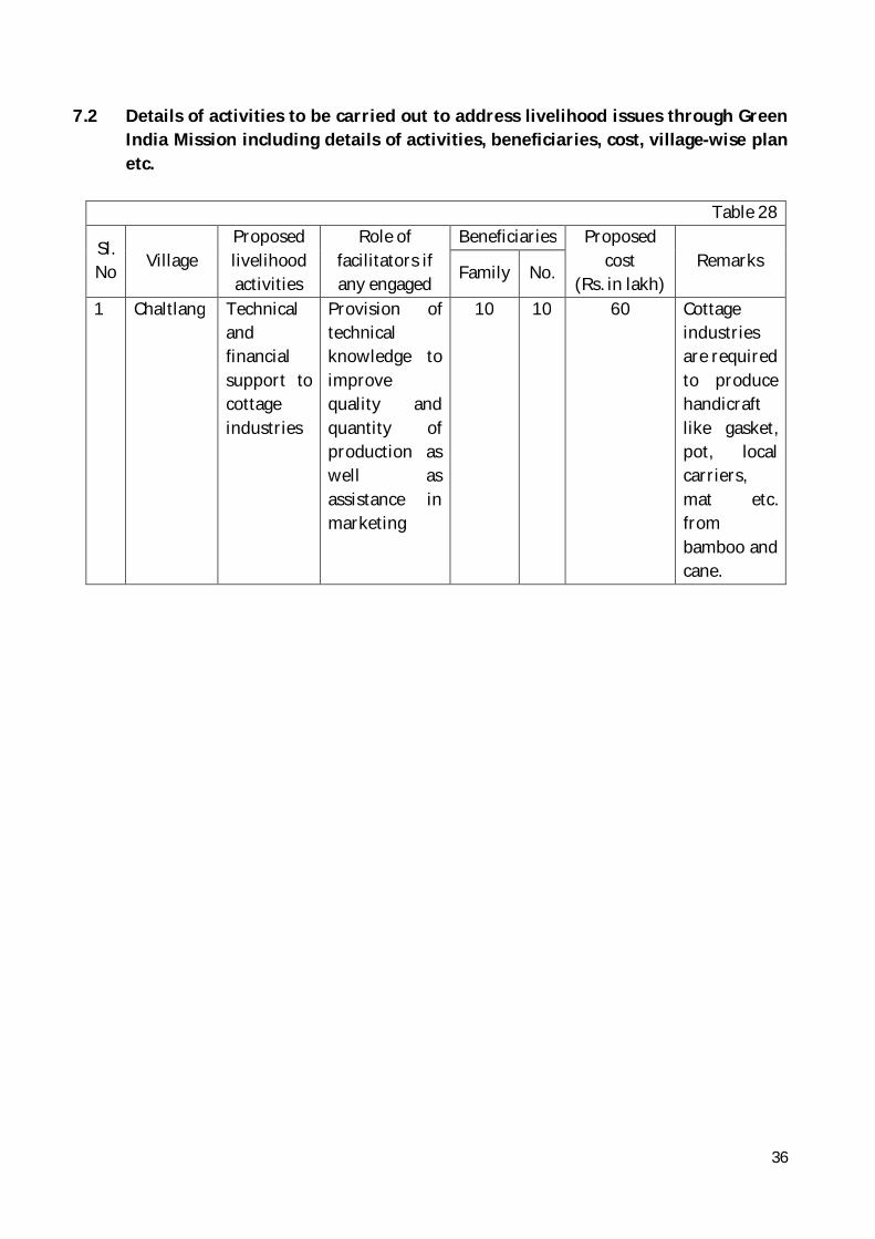
36
7.2 Details of activities to be carried out to address livelihood issues through Green India Mission including details of activities, beneficiaries, cost, village-wise plan etc.
Table 28
Sl. No Village
Proposed livelihood activities
Role of facilitators if any engaged
Beneficiaries Proposed cost
(Rs. in lakh) Remarks
Family No.
1 Chaltlang Technical and financial support to cottage industries
Provision of technical knowledge to improve quality and quantity of production as well as assistance in marketing
10 10 60 Cottage industries are required to produce handicraft like gasket, pot, local carriers, mat etc. from bamboo and cane.

37
Chapter 8 Baseline Survey
8.1 Baseline Survey
The baseline data for various parameters required for maintaining the outcomes of activities undertaken under GIM are given below:- Chaltlang village:
Table 30 Parameters Indicator Baseline Status
1. Forest/tree cover on forest/ non-forest lands-in-the-Mission Target Area (MTA)
a) % of area with forest cover
82.94% (Total forest cover 14.64 sq km out of 17.65 sq km)
b)% area in various forest density classes
1). Very dense =0.00 2). Moderately Dense =1.54% (1.52sqkm) 3). Open Forest =13.10% (13.10sqkm)
2. Eco-system services from targeted areas / landscapes
a) Shannon- Weiner Index
1.907
b) Biomass Above Ground Biomass = 100902.98 tonnes Source: Field survey data
3. Soil a) Depth of top soil The soil is very deep in valley i.e. flatlands whereas in the hills it is deep to moderately deep.
b) Soil quality The soils are lateric in nature, acidic upto 0 – 10 cm and coarse grain in the sub soil. The pH is normally 6.84. The soil organic carbon is measured 2.83% in 0-20cm in depth. The total nitrogen content of the soil in the depth was found to be 0.28%. The available phosphorous was found to be 6.00/g during rainy season. Exchangeable pottasium was measured at 959/g at 0 – 20 cm
4. Hydrology a) Wetland area b) Stream beds/
water discharge c) Ground water,
table – water level in wells/ springs
a) No wet lands in the area b) Spring and streams are found here. c) The area is hilly with variable elevation. Therefore, the ground water level varies. In the village settlement area, the depth of water in well is about 40 ft
5. Annual Sequestration of Co2
Carbon sequestered in the target area.
Baseline Carbon Stock = 365199.532 tonnes

38
6. Forest/ non-forest based livelihoods income
No. of targeted households (HH) reporting at least 25% increase in real income
Income (Rs. Annual)
No. of Households
More than 5 lakh 350 5 lakh >---<50,000
1208
Less than 50,000 142 7. Quality of forest
cover & ecosystem services of forest/non forests
b) % of forest area naturally regenerating
55% Source: GIS Cell, E&F Dept, Mizoram
a) Moderately dense forests
b) Biomass 10476.26 tonnes (AGB)
c) Open forests 90288.87 tonnes (AGB) d) Degraded
grasslands
No degraded Grassland
e) Wetlands No wetland area 8. Ecosystems are
restored and forest cover is cover is increased in scrub, shifting cultivation areas etc.
% of area that is adequate stocked / productivity
Nil
9. Forest and Tree cover in urban/peri-urban land
% of forest and tree cover in the targeted urban/peri-urban areas.
82.94 % (14.64 sq. kms. out of 17.65 sq. kms.) Source: GIS Cell,E&FDept Mizoram
10. Forest and tree cover on marginal agricultural lands/ fallow and other non- forest land under agro forestry/ social forestry
% of tree cover on non –forest land
32.67 % (5.7 sq. kms. out of 16.75 sq. kms.) Source: GIS Cell,E&FDept Mizoram
11. Public forest/ non forests areas (taken up under the Mission) are managed by the community
% of area under management of community institutions
66.388 % (11.80 sq. kms. out of 17.65 sq. kms.) Source: GIS Cell,E&FDept Mizoram

39
institutions. 12. improved fuel
wood-use efficiency and alternative energy devices adopted by households in MTA
% of HH reporting use of alternative energy devices
Total households = LPG users = Fuel-wood users = Fuel-wood only users= Solar devices users =
1700 1700 450 - 230
13. Forest/non forest based livelihoods of the people living in and around the forests are diversified.
% of HH reporting diversification of income sources
Source of income No. of households
Govt. Service 1300 Jhumming/Gardening - Horticulture including WRC 70 Business/Petty Trade 270 Daily labourers 200 Others -

40
Chapter 9 Status of reforms proposed
9.1 Role of Gram Sabha (Village Council) in project planning, implementation and
monitoring Village level GIM committee has been constituted by the State Government vide notification No.B.11016/16/2011-FST Dt 11.11.2014 (Annexure-IA) for the following activities:- 1. To render support in the preparation of Perspective Plan, 2. To ensure implementation of planned and approved schemes (approved by the
State Level Steering Committee and MoEFCC) with expected level of quality, 3. To promote active people’s participation in the implementation of “Green Indian
Mission” and 4. To provide feedbacks timely to concerned authorities for further improvement in
programme implementation.
Further, VFDC would play key role in project planning, monitoring and implementation under GIM. Both the VFDC and the Village Level GIM Committee would work closely in coordination with Gram Sabha (Village Council).
9.2 Revamping of FDAs and SFDAs
SFDAs and FDAs (General Body as well as Executive Committee) have been revamped for formulating suitable plans and executing well-planned projects with people’s participation under GIM in Mizoram. The SFDA (General Body) will provide overall guidance for effective implementation of “Green Indian Mission” in the State. It will also oversee implementation of the broad policy framework in achieving Mission goals and objectives. The Executive Committee of revamped SFDA has been entrusted with the following functions:
1. Approval of Perspective Plan as well as Annual Plan of Operations; 2. Preparation of annual reports on GIM implementation in the Sates; 3. Programmatic convergence at the landscape level
The revamped FDA (General Body) will deal with policy issues pertaining to
cohesion and convergence of different programmes at the Panchayat/Village Council level for better outcomes from the mission. The Executive Committee of revamped FDA will arrange for preparation of perspective plan/annual plan and convergence of various programmes.
41
9.3 FRAs compliance in areas covered under L2 and L3s Claims for rights in the forests would be settled strictly as per the relevant acts applicable in the State of Mizoram.
9.4 Easing out regulatory framework in felling and transportation of forest produce There is need to simply the procedure for issuing documents enabling felling and transportation of forest produce. The MoEFCC has recently taken initiative for simplifying rules and procedures for issue of permits and transit passes in respect of trees grown on non-forest private lands. The State of Mizoram would work in this direction in a proper way to motivate tree planters on non-forest private lands and also protect the valuable forest wealth existing in the State.
9.5 Strengthening frontline formation of E&F department Under Necessary actions would be taken for “Capacity Building” of frontline forest staff engaged in implementation of GIM in the State. Suitable training as well as required facilities would be provided to them for executing the planned works efficiently. It is expected that well-trained forest staff with people’s participation would be able to deliver the desired output/outcomes GIM.

42
Chapter – 10 Mission Cost
10.1 Cost of the Mission
Item wise and Year-wise cost of the mission for various work items has been given in the table place din Annexure – A1, A2 & A3
10.2 Mission sustainability
The mission will be executed with active participation of the local people. On completion of the project, crop productivity of the existing forest will increase substantially. Sustainable extraction of forest produce, value addition to forest produce as well as marketing of value added products will provide livelihood support to the people while maintaining ecological stability in the region. Thus the mission is economically viable and socially adoptable.

43
Abstract
Table 1. Name of L1 landscape The State of Mizoram 2. Name of L2 landscape Aizawl City 3. Forest and non-forest area in L2 Forest area- 128.42 sq.kms, Non-forest area-
79.16 sq.kms 4. Drivers of degradation in the landscape Traditional practice of shifting cultivation,
Lack of strategic and participatory land-use planning, excessive population pressure on the forests for fuel-wood, fodder, timber etc., inadequate scientific management of watersheds including rainwater harvesting.
5. Results of problem analysis The analysis of survey data shows that the area is in need of proper scientific treatment to reduce or reverse the ongoing ecosystem degradation.
6. Existing scheme implemented in the landscape
NAP, NBM , NLUP & IAY
7. Implementing agencies under GIM Revamped FDA, Aizawl 8. GIM activities :-
(a) Submission/Category Funding
Rs. in lakh 1. Enhancing quality of forest cover
20.250 a) Moderately dense forest cover but showing degradation
b) Eco restoration of degraded open forests
“Type (A)” 30.240
c) Eco restoration of degraded open forests “Type C”
162.000
2. Ecosystem restoration and increase in forest cover
121.500
3. Enhancing tree cover in Urban & Peri-urban areas (including institutional lands)
94.500
4. Agro forestry and social forestry (increasing bio-mass and creating carbon sink)
a)Farmer's land including current fallow 43.200
b)Highways/ruralroads/Canals/ Tank bunds 28.350
Sub Total A 500.040

44
B 5. LPG connection to BPL families 3.96
6. Solar devices 2.64 Sub Total B 6.60
(C) Other support activities 1. Research 10.133 2. Publicity/Media/Outreach activities 5.066 3. Monitoring and Evaluation 5.066 4. Strengthening local-level institutions 25.332 5. Strengthening FDs 25.332 6. Mission organization, operation and
maintenance, contingencies and overheads 20.266
Sub Total C 91.195 (D) Livelihood activities 86.129
Sub Total D 86.129 (E) Community conserved area and
Sacred groves
1. Improvement planting with protection activities. 5.13
Sub Total E 5.13 Total (A+B+C+D+E) 689.094

45
WORKS DETAILS UNDER DIFFERENT SUBMISSIONS OF L3 LANDSCAPE " CHALTLANG"
Sl. No
Sub- mission/
intervention Category Type Rate/Ha.
(Rs.)
Total Phy
target for
2016-17 to 2017-
18
2016-17 2017 - 2018 2018 - 2019 2019 - 2020 2020 -2021 2021 - 2022 2022 -2023
Total Phy
Total amount Activity
undertaken
Fin already
achieved Phy Fin Total Phy Fin Phy Fin Phy Fin Phy Fin Phy Fin
1 2 3 6 7 8 9 10 11 12 13 14 15 16 17 22 23 A .Sub Missions and Interventions
1 Sub-mission 1 : Enhancing quality of existing forest cover
Category a) Moderately dense forest cover but showing degradation
ANR Without Plantation 25 11 Advance work 9450 7.14 0.675 14 1.323 25 2.363 50 4.360 Adv. Work (Bal of 2016-17) 9450 3.86 3.86 0.365 0.365 Creation 15660 7.14 1.119 14 2.192 25 3.915 7.226 Creation (Bal of 2016-17) 15660 3.86 0.604 0.604 1st yr maintenance 9720 7.14 0.694 14 1.361 25 2.43 4.485 1st yr main (Bal of 2016-17) 9720 3.86 0.375 0.375 2nd yrs maintenance 3510 7.14 0.251 14 0.491 25 0.8775 1.620 2nd yr main (Bal of 2016-17) 3510 3.86 0.135 0.135 3rd yr maintenance 2160 7.14 0.154286 14 0.3024 25 0.54 0.997 3rd yr main (Bal of 2016-17) 2160 3.86 0.0833 0.083
Sub Total 40500 11 0.675 25 2.806 3.481 50 5.853 50 5.901 50 3.211 42.8572 1.263 25 0.54 20.250 Category b) Eco restoration of degraded open forests Type A 200 Plants /Ha.
200 Plants / Ha (Type A) 30 13 Advance work 8100 12 0.972 17 1.3770 40 3.24 70 5.589 Adv. Work (Bal of 2016-17) 8100 1 1 0.081 0.081 Creation 15390 12 1.847 17 2.616 40 6.156 10.619 Creation (Bal of 2016-17) 15390 1 0.154 0.154 1st yr maintenance 8100 12 0.972 17 1.377 40 3.24 5.589 1st yr main (Bal of 2016-17) 8100 1 0.081 0.081 2nd yrs maintenance 6480 12 0.778 17 1.102 40 2.592 4.471 2nd yr main (Bal of 2016-17) 6480 1 0.065 0.065 3rd yr maintenance 5130 12 0.616 17 0.872 40 2.052 3.540 3rd yr main (Bal of 2016-17) 5130 1 0.051 0.051
Sub Total 43200 26 0.972 30 3.305 4.277 70 6.982 70 8.392 70 5.022 58 3.515 40 2.052 30.240 2500 Plants / Ha (Type C) 50 17
Advance work 25650 14.21 3.645 33 8.465 70 17.955 120 30.064 Adv. Work (Bal of 2016-17) 25650 2.79 2.79 0.716 0.716 Creation 53460 14.21 7.597 33 17.642 70 37.422 62.660 Creation (Bal of 2016-17) 53460 2.79 1.492 1.492 1st yr maintenance 20250 14.21 2.878 33 6.683 70 14.175 23.735 1st yr main (Bal of 2016-17) 20250 2.79 0.565 0.565 2nd yrs maintenance 18090 14.21 2.571 33 5.970 70 12.663 21.203 2nd yr main (Bal of 2016-17) 18090 2.79 0.505 0.505 3rd yr maintenance 17550 14.21 2.494 33 5.792 70 12.285 20.570 3rd yr main (Bal of 2016-17) 17550 2.79 0.490 0.490
Sub Total 135000 17 3.645 50 16.777 20.422 120 39.966 120 47.240 120 23.143 105.79 18.944 70 12.285 162.000

46
contd/- 2 Sub-
mission 2: Ecosystem restoration and increase in forest cover
Category a) Rehabilitation of shifting cultivation areas
1100 Plants / Ha. 70 29 Advance work 18360 16.76 3.077 41 7.528 80 14.688 150 25.293 Adv. Work (Bal of 2016-17) 18360 12.24 12.24 2.247 2.247 Creation 36450 16.76 6.109 41 14.945 80 29.160 50.214 Creation (Bal of 2016-17) 36450 12.24 4.461 4.461 1st yr maintenance 11340 16.76 1.901 41 4.649 80 9.072 15.622 1st yr main (Bal of 2016-17) 11340 12.24 1.388 1.388 2nd yrs maintenance 8100 16.76 1.358 41 3.321 80 6.48 11.159 2nd yr main (Bal of 2016-17) 8100 12.24 0.991 0.991 3rd yr maintenance 6750 16.76 1.131 41 2.768 80 5.4 9.299 3rd yr main (Bal of 2016-17) 6750 12.24 0.826 0.826
Sub Total 81000 29 3.077 70 15.88
4 18.96
1 150 35.995 150 36.555 150 14.516 133.24 10.074 80 5.4 121.500 3 Sub-
mission 3: Enhancing tree covers in urban and peri urban areas
Category a) Plantation in urban and peri uraban areas
2500 Plants/ Ha. 35 12 Advance work 59400 8.829 5.244 23 13.662 35 18.906 Adv. Work (Bal of 2016-17) 59400 3.171 3.171 1.884 1.884 Creation 81000 8.829 7.151 23 18.630 25.781 Creation (Bal of 2016-17) 81000 3.171 2.569 2.569 1st yr maintenance 59400 8.829 5.244 23 13.662 18.906 1st yr main (Bal of 2016-17) 59400 3.171 1.884 1.884 2nd yrs maintenance 35100 8.829 3.099 23 8.073 11.172 2nd yr main (Bal of 2016-17) 35100 3.171 1.113 1.113 3rd yr maintenance 35100 8.829 3.099 23 8.073 11.172 3rd yr main (Bal of 2016-17) 35100 3.171 1.113 1.113
Sub Total 270000 12 5.244 35 22.69
7 27.94
1 35 26.443 35 18.645 35 12.285 26.171 9.186 0 0 94.500 4 Sub-
mission 4: Agro forestry and social forestry
Category a) Farmers land including current fallows
Farmers land 40 16 Advance work 13500 12.45 1.681 24 3.240 40 5.4 80 10.321 Adv. Work (Bal of 2016-17) 13500 3.55 3.55 0.479 0.479 Creation 20250 12.45 2.521 24 4.860 40 8.100 15.481 Creation (Bal of 2016-17) 20250 3.55 0.719 0.719 1st yr maintenance 7020 12.45 0.874 24 1.685 40 2.808 5.367 1st yr main (Bal of 2016-17) 7020 3.55 0.249 0.249 2nd yrs maintenance 6750 12.45 0.840 24 1.620 40 2.7 5.160 2nd yr main (Bal of 2016-17) 6750 3.55 0.240 0.240 3rd yr maintenance 6480 12.45 0.807 24 1.555 40 2.592 4.954 3rd yr main (Bal of 2016-17) 6480 3.55 0.230 0.230
Sub Total 54000 16 1.681 40 6.240 7.921 80 11.853 80 10.874 80 5.474 67.55 4.485 40 2.592 43.200 Category b) Highways/ Rural Roads/Canals/Tank bunds
Roads/Canals/Tank Bunds 15 7 Advance work 29700 6.42 1.907 8.00 2.376 15 4.283 Adv. Work (Bal of 2016-17) 29700 0.58 0.58 0.172 0.172 Creation 83700 6.42 5.374 8.00 6.696 12.070 Creation (Bal of 2016-17) 83700 0.58 0.485 0.485 1st yr maintenance 32400 6.42 2.080 8.00 2.592 4.672 1st yr main (Bal of 2016-17) 32400 0.58 0.188 0.188 2nd yrs maintenance 21600 6.42 1.387 8.00 1.728 3.115 2nd yr main (Bal of 2016-17) 21600 0.58 0.125 0.125 3rd yr maintenance 21600 6.42 1.387 8.00 1.728 3.115 3rd yr main (Bal of 2016-17) 21600 0.58 0.125 0.125
Sub Total 189000 7 1.907 15 7.922 9.829 15 9.262 15 4.167 15 3.240 8.58 1.853 28.350 TOTAL OF SUB MISSIONS 265 118 17.201 265 75.631 92.832 520 136.353 520 131.774 520 66.891 442 49.321 255 22.869 520 500.040

47
5 Promoting alternative feul energy
Biogas, solar devices, LPG, Biomass based systems, improved stoves
Per Household 3300
100 3.3 3.3 100 3.3
200 6.6
TOTAL OF A 265 118 17.201 365 96.1 96.1 620 139.653 520 131.774 520 66.891 442.1882 49.321 255 22.87 720 506.640 B FOR SUPPORT ACTIVITIES
Research (2%) 1.923 2.793 2.635 1.338 0.986 0.457 10.133 Publicity/Media/Outreach activities 1% 0.961 1.397 1.318 0.669 0.493 0.229 5.066 Monitoring & Evaluation (1%) 0.961 1.397 1.318 0.669 0.493 0.229 5.066 Livelihood activities (17%) 16.34 23.741 22.402 11.372 8.385 3.888 86.129 Strengthening local level institutions (5%) 0.03 4.777 6.983 6.589 3.345 2.466 1.143 25.332 Strengthening FDs(5%) 4.807 6.983 6.589 3.345 2.466 1.143 25.332 Mission organisation, Operation maintenance, Overheads (4%) 3.845 5.586 5.271 2.676 1.973 0.915 20.266 TOTAL OF B 33.65 48.879 46.121 23.412 17.262 8.004 177.324 TOTAL OF A+B 129.8 188.53 177.894 90.303 66.583 30.873 683.964

48
GREEN INDIA MISSION - AIZAWL FOREST DIVISION, MIZORAM ANNUAL PLAN OF OPERATION (APO)
CHALTLANG(L3) LANDSCAPE (2017-18)
Sub-Mission/ Intervention Category Items of Work
Rate per Ha. (in Rs.)
2017-18 Physical Target (in Ha.)
Financial Outlay
(in lakh) A.
Sub-Mission- 1: Enhancing
quality of forest cover and improving ecosystem
services
a) Moderately dense forest but showing degradation
1) Advance Work 9450 14 1.323 2) Creation 15660 11 1.723 3)Adv. Work (Balance of 2016-17) 4050 11 0.446
3.491 b) Eco-restoration of degraded open forests (Type A)
1) Advance Work 8100 17 1.377 2) Creation 15390 13 2.001 3)Adv. Work (Balance of 2016-17) 1350 13 0.1755
3.553 b) Eco-restoration of degraded open forests (Type C)
1) Advance Work 25650 33 8.465 2) Creation 53460 17 9.088 3)Adv. Work (Balance of 2016-17) 8640 17 1.469
Sub total 19.022 Sub-Mission - 2: Ecosystem restoration and increase in forest cover (1.8 mha)
a) Rehabili-tation of Shifting Cultivation Areas
1) Advance Work 18360 41 7.528 2) Creation 36450 29 10.571
3)Adv. Work (Balance of 2016-17) 7290 29 2.114
Sub total 20.212 Sub-Mission - 3: Enhancing tree cover in Urban and Peri- Urban areas (including institutional lands
a) Plantation in Urban and Peri -Urban areas
1) Advance Work 59400 23 13.662 2) Creation 81000 12 9.720
3)Adv. Work (Balance of 2016-17) 13500 12 1.620
Sub total 25.002 Sub-Mission - 4:
Agro-Forestry and Social Forestry
(increasing biomass &
creating carbon sink) : 3 m ha
a) Farmer's land including current fallows
1) Advance Work 13500 24 3.240 2) Creation 20250 16 3.240 3)Adv. Work (Balance of 2016-17) 5130 16 0.821
7.301
c) Highways/ Rural Roads/ Canals/ Tank Bunds
1) Advance Work 29700 9 2.673 2) Creation 83700 6 5.022 3)Adv. Work (Balance of 2016-17) 4590 6 0.275
Sub total 7.970 Total of A. 86.551
Sub-Mission 5: Promoting alternative fuel energy
Biogas, solar devices, LPG, Biomass-based systems, improved stoves
Perhousehold 3300 100 3.3
B. FOR SUPPORT ACTIVITIES Research ( 2% of A) 1.731 Publicity / Media (1% of A) 0.866 Monitoring & Evaluation (1%of A) 0.866 Livelihood improvement activities (17% of A) 14.714 Strengthening local – level inst. (5% of A) 4.328 Strengthening FDs (5% of A) 4.328 Mission organisation, operation and maintenance, contingencies and overheads (4% of A) 3.462
Total of C 30.293 GRAND TOTAL (A+B+C) 116.844

49

50

51

52

53

54

55

56

57

58

59
CALCULATIONS OF TOTAL CARBON STOCK 2017 AIZAWL L2 CHALTLANG L3
Sl.No. PLOT NO. VOLUME GS AGB AGC BGB DWB LBM SOC CS
Total Forest area
in Ha.
1 2 4 5 6 7 8 9 10 11 13 1 9 3.670099 1464 2 16 3.702215 3 17 1.399624 4 18 3.925971 5 28 3.726397 6 44 1.016742 7 50 3.985725 8 77 3.99427
25.42104 76.580893 68.9228 25.50144 32.393718 11.144817 3.271 57.14 249.45323 TOTAL 112114.43 100903 37334.1 47424.403 16316.013 4788.74 83653 365199.53

60
SHANON WEINER BIODIVERSITY INDEX UNDER L2 AIZAWL
Chaltlang L3 PLOT No. A1/9 Sl
No Tree Species No of trees
Shannon Index Calculation
1 2 3 4 1 Schima wallichii 7 0.34657359 2 Sterculia Vellosa 3 0.330095366 3 Cardia Freagrantissima 1 0.188504095 4 Bauhinia Variagata 1 0.188504095 5 Derris robasta 1 0.188504095 6 Macaranga Indica 1 0.188504095
SUM: 14 1.430685336
PLOT No. 16
Sl No Tree Species
Count the Trees of
each species
Shannon Index Calculation
1 2 3 4 1 Schima wallichii 11 0.189484473 2 Sterculia Vellosa 2 0.277987164 3 Launca caromandelica 2 0.277987164 4 Albizzia odoratissima 2 0.277987164 5 Albizzia Chinansis 1 0.188504095 6 Gmelina arborea 2 0.277987164 7 Calocorpa arborea 2 0.277987164 8 Michilia champala 1 0.188504095 9 Embreca officinalis 1 0.188504095
10 Adena Cardifolia 1 0.188504095 11 Apolusa octandra 1 0.188504095
SUM: 26 2.521940769
PLOT No. 17
Sl No Tree Species
Count the Trees of
each species
Shannon Index Calculation
1 2 3 4 1 Apolusa octandra 1 0.188504095 2 Calicarpa arboria 1 0.188504095 3 Schima wallichii 2 0.277987164
SUM: 4 0.654995354

61
PLOT No. 18
Sl No Tree Species
Count the Trees of
each species
Shannon Index Calculation
1 2 3 4 1 Schima wallichii 9 0.284035341 2 Lannca coromandelica 2 0.277987164 3 Albizzia Chainansis 1 0.188504095 4 Adina cardifolia 2 0.277987164 5 Callicarpa arbona 2 0.277987164 6 Colona florabunda 1 0.188504095 7 Cardea fragrantissima 1 0.188504095 8 Albizzia procera 1 0.188504095 9 Derris robusta 1 0.188504095
10 Apolusa octandra 1 0.188504095 SUM: 21 1.220507639
PLOT No. 28
Sl No Tree Species
Count the Trees of
each species
Shannon Index Calculation
1 2 3 4 1 Schima wallichii 3 0.330095366 2 Albizzia adoralissima 1 0.188504095 3 Sterculea Vellosa 1 0.188504095 4 Calicarpa arborea 1 0.188504095 5 Adena cardefolia 1 0.188504095 6 Derris robusta 1 0.188504095
SUM: 8 1.272615841

62
PLOT No. 44
Sl No Tree Species
Count the Trees of
each species
Shannon Index Calculation
1 2 3 4 1 Albizzia Chainansis 3 0.330095366 2 Teetona grandis 4 0.357932277 3 Derris robusta 3 0.330095366 4 Amorea Chittagonga 1 0.188504095 5 Calicarpa arboria 1 0.188504095 6 Aporusa oetandna 1 0.188504095 7 Gmelina arboria 3 0.330095366 8 Schima wallichii 1 0.188504095 9 Protium seratum 1 0.188504095
10 Sterculea Vellosa 1 0.188504095 11 Macaranga indica 2 0.277987164 12 Albizzia Chainansis 1 0.188504095 13 Oreocnide integrifolia 1 0.188504095 14 Albizzia procera 2 0.277987164 15 Bischofia joponics 1 0.188504095
SUM: 26 3.600729558
PLOT No. 50
Sl No Tree Species
Count the Trees of
each species
Shannon Index Calculation
1 2 3 4 1 Albizzia Chainansis 1 0.188504095 2 Antocarpus laterophytics 3 0.330095366 3 Aprocusa octandra 1 0.188504095 4 Gmelina arboria 5 0.36772122 5 Lannca coromandelica 4 0.357932277 6 Anogerous acuminata 1 0.188504095 7 Emblica officinalis 1 0.188504095 8 Azaderachta indica 2 0.277987164 9 Calicarpa arboria 1 0.188504095
10 Mangifera indica 1 0.188504095 11 Adina cardifolia 1 0.188504095
SUM: 21 2.653264692
TOTAL 13.35473919 SHANON WEINER INDEX 1.907819884