greening america’s capitals - dmgov.org · greening america’s capitals is an epa program to ......
TRANSCRIPT

GreeninG AmericA’s cApitAlsdes moines, iowA
September 2013www.epa.gov/smartgrowth
EPA Office of Sustainable CommunitiesSmart Growth Program

PhotograPhy Credits:all photographs and graphics were either created by or the rights are owned by the Vireo/BNiM team.

BNIM 317 6th Avenue Suite 100Des Moines, IA 50309 515.974.6462
VIREO1111 N. 13th Street, Suite 116Omaha, NE 68102402.553.5485
EPAOffice of Sustainable Communities1200 Pennsylvania Avenue N.W.Mail Code 1807TWashington, DC 20004
September 2013www.epa.gov/smartgrowth
GreeninG AmericA’s cApitAlsdes moines, iowA

greening america’s Capitals is an ePa program to help state capitals develop an implementable vision of distinctive, environmentally friendly neighborhoods that incorporate innovative green infrastructure strategies. in collaboration with the U.s. department of housing and Urban development (hUd) and the U.s. department of transportation (dot) through the Partnership for sustainable Communities, ePa provides design assistance to help support sustainable communities that protect the environment, economy, and public health and to inspire state leaders to expand this work elsewhere. greening america’s Capitals helps communities consider ways to incorporate sustainable design strategies into their planning and development to create and enhance interesting, distinctive neighborhoods that have multiple social, economic, and environmental benefits. des Moines was chosen in 2012 as one of five state capital cities to receive this assistance, along with Baton rouge, Louisiana; Frankfort, Kentucky; helena, Montana; and indianapolis, indiana. More information about greening america’s Capitals is at www.epa.gov/smartgrowth/greencapitals.htm.

executive summAry
introduction 01
workshop description 03
project AreA Assessment 05
desiGn concepts 13
next steps, key pArtners, And cAse studies 31
tAble of contents


executive summAry
des Moines has selected 6th avenue to receive streetscape improvements that add green infrastructure for a range of community, economic, and environmental benefits. the city wants to create a new model for infrastructure upgrades and investment in an area that has suffered the effects of decades of disinvestment.
the city asked the U.s. environmental Protection agency (ePa) for help with this effort through the greening america’s Capitals program. this report includes a description of the three-day workshop held in the project area to engage stakeholders, residents, business owners, and community members in a process that outlined goals for the projects and developed design options that respond to those goals. the report also includes an assessment of the 6th avenue corridor, outlining both assets and challenges that informed the design concepts. a set of design concepts are presented for several key locations chosen by the city and the 6th avenue Corridor nonprofit. these locations were chosen based on their potential to help area businesses and residents, as well as their capacity to illustrate the transformative potential of green and complete streets. the design
concepts illustrate improved pedestrian amenities and safety features for pedestrians and bicyclists, as well as integrated green infrastructure components such as rain gardens, bioswales, and large street trees.
Lastly, this report provides a few case study examples from other communities that have accomplished similar projects, as well as a list of potential next steps that the city and its partners could follow if they choose to implement the priority projects discussed during the workshop.

1
introduction
the city of des Moines and its main partner in the area, the 6th avenue Corridor nonprofit, requested assistance from the ePa’s greening america’s Capital program to focus on improvements to a one-mile stretch of 6th avenue. the 6th avenue corridor is close to downtown and has access to one of the city’s primary natural treasures, the des Moines river. integrating green infrastructure improvements along 6th avenue would encourage investment and support the neighborhood’s vision to be a vibrant place to socialize, work, shop, play, and live.
green infrastructure includes a range of natural and built approaches to stormwater management–such as rain gardens, bioswales, and permeable paving–that mimic natural systems by cleaning stormwater and letting it absorb back into the ground. green infrastructure strategies for streets can include a connected system of inlets, basins, and outlets for tree planters and other landscaping that allow stormwater to flow into the planting beds and slowly soak into the soil. Carefully selected perennial native plants could assist in removing the pollutants from the stormwater and require less maintenance and irrigation than annual varieties. green infrastructure could reduce the amount of runoff that enters the traditional piped stormwater system below ground, and could prevent overflows that pollute nearby water bodies. green infrastructure offers a range of additional environmental, economic, and community benefits, including more walkable streets, reduction of heat
island effects, increased property values, and more gathering spaces that benefit residents and customers of local businesses. 1 Maintenance programs for green infrastructure solutions offer the possibility of green jobs, environmental education for adults and kids, and research to advance science and technology of successful green infrastructure solutions.
the design concepts in this report illustrate complete streets strategies combined with green infrastructure strategies. “Complete streets” refers to a set of strategies that make streets and sidewalks safe for all users, including pedestrians, bicyclists, drivers, and transit riders. however, a street is not necessarily “complete” without considering its environmental performance. incorporating green infrastructure into street design adds the environmental component. streets that have green infrastructure elements are often called “green streets.” For purposes of this report, the term “green and complete street” will be used.
ePa funded a team of consultants that worked with city staff, local business owners, residents, and other stakeholders to develop design options to revitalize this commercial street. the design concepts include wider sidewalks, narrower traffic lanes, better lighting, and improved bus stop shelters, as well as street trees, permeable pavement, and rain gardens to minimize stormwater runoff. the city plans to use the 6th
1 U.s. ePa office of Water. Why green infrastructure?, http://water.epa.gov/infrastructure/greeninfrastructure/gi_why.cfm.
avenue project to guide designs for other planned streetscape improvements throughout the city.
the greening america’s Capitals design team visited the city, conducted interviews with the city planner and 6th avenue Corridor nonprofit director, collected local data and maps, and used this information to establish a baseline analysis of the area. ePa, the city of des Moines, and the design team then held a three-day workshop with stakeholders and residents to understand local priorities and challenges for 6th avenue, as well as potential partnerships to move infrastructure and development projects forward.
the concept designs for 6th avenue adhere to the 6th avenue streetscape Conceptual design, which the des Moines City Council approved in fall 2012 and which recommended decreasing the number of driving lanes along 6th avenue. the Council-approved design was proposed for 6th avenue because of the many challenges of the corridor, including: lack of adequate pedestrian facilities; safety issues due to cars that are changing lanes or trying to bypass turning vehicles; and poor visibility for cars turning left when an opposing driver is also turning left.
the city’s traffic studies have shown that restriping four-lane streets to have only three-lanes can reduce vehicle speeds, improve sight distance for left turns and driveway exits, and eliminate passing vehicles, all of which result in a reduction in crashes. Narrowing streets also allows for the pedestrian facilities, such

2
as crosswalks, to be improved. 6th avenue carries approximately 13,000 vehicles per day, according to 2010 counts. three-lane restriping projects are appropriate at volumes of up to 18,000 vehicles per day.
during the greening america’s Capitals project, workshop participants refined the vision and priorities of this recent streetscape design to include environmental benefits, education, community identity, and a focus on public health.
Figure 1 this map is oriented with north to the right of page. the project area is bounded by the highway to the south and the river to the north. it includes a hospital complex; a new grocery store; and commercial, nonprofit, and residential uses.
Project boundary
Neighborhood boundary
n
0 1/8 1/4 1/2 mile
each of the design concepts provides a before and after image of key locations along the 6th avenue corridor. the sequence of the design concepts moves from south to north, beginning with the gateway at Mercy Medical Center and ending at Franklin avenue, just before the river. the designs also provide ideas for using vacant parcels that could be part of the incremental transformation of this corridor into a thriving area of small businesses, cultural events, and homes for a diverse population.
the projects and programs that are a part of this transformation include education for all ages about green infrastructure, new job training and employment opportunities around maintenance of green infrastructure, and public space improvements that involve local residents and community members.

3
workshop description
the city of des Moines office of Planning and Community development hosted a three-day design workshop facilitated by a group of consultants with expertise in landscape architecture, street design, implementation and maintenance of green infrastructure solutions, and city planning. the workshop convened stakeholders from the 6th avenue area, including business owners; directors of nonprofits, institutions, and educational programs; and representatives from city departments who will be involved in the implementation of the redesigned streetscape. Workshop attendees based their discussions on three main goals identified by the city and the 6th avenue Corridor organization:
• Cultivating environmental stewardship.
• reinforcing connectivity and complete streets.
• strengthening local businesses and neighborhoods.
stakeholders discussed the vision and priorities of the recently completed streetscape study and helped the design team refine a set of key issues to address in the greening america’s Capitals design study. the group agreed to revise the vision of the recent streetscape study to include a focus on safety and an emphasis on the neighborhood’s rich cultural diversity. the priorities of the streetscape study were revised to include environmental benefits, education, community identity, and public health.
the revised vision and priorities are:
The 6th Avenue Corridor through the historic River Bend and Cheatom Park neighborhoods is a vibrant, safe, pedestrian-friendly, culturally and historically rich area that encourages all of Des Moines to socialize, work, shop, play, and live.
streetscape Priorities:
• Widen the sidewalk and improve pedestrian amenities.
• design for pedestrian safety by providing crosswalks and lighting improvements.
• design a bicycle-friendly street with shared lanes and bike parking.
• retain on-street parking for businesses.
• improve bus stops.
• Provide multiple benefits with streetscape enhancements, including:
• Beautification with street trees and flower planters.
• environmental benefits and water conservation.
• Connection to the river and green spaces.
• Quality of built environment.
• education, stewardship, and community pride.
• regulatory compliance for water quality.
• identity art programs based on local cultural talent.
Neighborhood Priorities:
• Connect to the des Moines river and continue to support 6th avenue river bridge improvements.
• improve pedestrian safety at 6th avenue’s intersections with hickman road and University avenue.
• improve safety through traffic calming.
• Focus on public health and public safety through health care access, food access, active lifestyle, and more “eyes on the street.”
• encourage current and new businesses in the neighborhood.
• support historic preservation.
• add public art to define a sense of place.
the design team synthesized the input and community priorities to develop preliminary design ideas and get feedback from the community. Community members expressed enthusiasm for the preliminary design concepts and for green infrastructure pilot projects proposed for 6th avenue.

4
Figure 2 the images above show the convenings on all three days as well as a few of the sketches produced during the workshop from community input on streetscape priorities, green infrastructure solutions, and ideas for infill development and public spaces.

5
project AreA Assessment
Figure 3 river Bend and Cheatom neighborhoods are home for many young families and adults, but not many young professionals.
the 6th avenue corridor was selected by city staff and neighborhood partners as the project area for the greening america’s Capitals assistance because it includes a mix of assets and challenges that make it ripe for investments that can improve the public realm to benefit the community, the local economy, and the environment.
residents of this area come from many different backgrounds. demographic data shows that there is a large population under the age of 17, and a low number of 18-21 year olds in comparison to the other age ranges. this chapter includes descriptions of the major assets and challenges in the area, as well as maps and images that represent the neighborhood’s character and context.
Assets
the assets of this richly diverse neighborhood include its proximity to downtown and the des Moines river, its history, and the people who call it home. the city and residents are committed to 6th avenue’s revitalization. this commitment is shown by recent investment in planning for improvements to the corridor, including the city Council-approved 6th avenue streetscape Conceptual design to reduce traffic lanes and widen sidewalks, add green infrastructure, integrate arts 1 programming into neighborhood planning initiatives, and install a new pedestrian bridge and a public arts
1
project at the des Moines river.2 other recent planning documents include: the river Bend Neighborhood Plan update (2011), dart Forward 2035 Plan (2011), Capital Crossroads strategic Plan (2011), Un Nuevo amanecer: defining Place on 6th avenue (funded by greater des Moines Public art Foundation, 2012), and the tomorrow Plan, Central iowa’s regional plan for sustainability (2013). residents and stakeholders, including Mercy Medical Center and the des Moines area Community College, are engaged in the conversations about neighborhood revitalization efforts.
2 City of des Moines Community development. 6th avenue streetscape Plan, http://www.dmgov.org/departments/Communitydevelopment/Pages/NeighborhoodPlans.aspx.

6
the many historic structures along the corridor and in the neighborhoods contribute to the sense of place. the fifteen buildings on the National register of historic Places give the corridor a rich aesthetic and visual identity. revitalization efforts in the neighborhood could help preserve and reinvest in this historic building stock alongside new infrastructure improvements.
the area has good access to public transportation, which provides options for getting around des Moines. every block along the corridor has a bus stop. a recent transit study recommended improvements to routes, stop locations, and shelters in the area. these improvements could allow people who do not own cars wider access to jobs, education, and cultural amenities. the planned bike lanes on College avenue and Forest avenue would create safer cycling environments and encourage healthier lifestyles for people who live and work in this area. the bike and pedestrian connections to the des Moines river provide an opportunity to explore one of the city’s natural treasures and could help 6th avenue become part of a larger bicycle commuter corridor.
Figure 4
While there is not a predominate architectural style along the 6th avenue Corridor, there are 15 buildings along the corridor that are on the National register of historic Places. these historic structures were built to last, and lend some stability to the eclectic and evolving aesthetic of this area.
Figure 5 the neighborhood’s access to buses helps connect residents to the rest of the city.

7
Figure 6 these two small businesses along the corridor reflect the many ethnicities and cultures in the neighborhoods.
UN
IVE
RS
ITY
I-235
IND
IAN
A
FO
RE
ST
CL
AR
K
CO
LL
EG
E
FR
AN
KL
IN
6TH AVENUE 6TH AVENUE
CR
OC
KE
R
WO
OD
S P
AR
KB
IRD
LA
ND
S
PO
RT
S P
AR
K
DE
S M
OIN
ES
RIV
ER
Figure 7 Many social service providers, schools, and churches are located along or close to 6th avenue. these organizations provide valuable services to the neighborhood.
n
soCiaL serViCes, sChooLs or ChUrChes
the area’s ethnic diversity creates a rich neighborhood culture. the current population includes families from Laos, Vietnam, Nigeria, sudan, Central america, and south america in addition to those of european descent. Local businesses and residential areas reflect this rich diversity and proposed corridor improvements can build on and support these many different cultures through good design of public space, an environment that supports small local businesses, and neighborhood participation in programming for arts, education, and social events.
the many social services, schools, and churches create a strong support network for neighborhood and city residents. Local social service providers include the young Men’s Christian association (yMCa), des Moines area Community College, Mercy Medical Center, Moulton elementary school, and several family support organizations. these neighborhood organizations support new reinvestment in the corridor and can work to ensure social equity for all people as the corridor develops.

8
5 MINUTE BIK
E R
IDE
1 MILE1/2 MILE 1.5 MILE
10 M
INU
TE
BIK
E R
IDE
20
MIN
UT
E B
IKE
RID
E
Figure 9 the 6th avenue corridor project area is a short walk or bike ride away from downtown des Moines.
Figure 8 With close proximity to the des Moines river and riverside trail, 6th avenue connects to one of the region’s major natural resources that provides residents with many outdoor recreation opportunities.
n ProJeCt area
the neighborhood includes the des Moines river and riverside trails, which provide residents with outdoor recreation options that can be rare in a city. recent bridge and trail improvements have increased access to this natural amenity. green infrastructure improvements on the corridor could enhance the connection to the river and trails and highlight the river’s role as a prominent feature of the neighborhood. these improvements could reduce the amount of pollution and stormwater runoff that flows into the river. Public art and educational signage could educate residents about the connections between stormwater runoff and the river’s water quality, perhaps inspiring them to incorporate green infrastructure such as rain gardens and rain barrels in their own back yards.
the corridor is less than two miles from downtown des Moines, making it a walkable or bikeable destination from the center of the city. the 6th avenue area includes commercial uses, the des Moines area Community College, an elementary and high school, a regional park, and a connection to regional trails along the des Moines river.

9
Figure 10
6th avenue forms the backbone of neighborhood activity as the main street with commercial services. the well-connected grid of streets provide residents with short distances for walking and biking.
Figure 11
redeveloping vacant parcels, like this one at College and 6th, could help create a more walkable and inviting area for residents and businesses.
UN
IVE
RS
ITY
INSTITUTIONAL
COMMERCIAL
MULI-FAMILY RES
SINGLE-FAMILY RES
FO
RE
ST
CO
LL
EG
E
FR
AN
KL
IN
6TH AVENUE
5 M
INU
TE
BIK
E R
IDE
5 MIN
UT
E W
AL
K
1/4 MILE
1/2 MILECoMMerCiaLMULti FaMiLy resideNtiaLsiNgLe FaMiLy resideNtiaLiNstitUtioNaL
this area has a well-connected grid of streets with short block lengths and a mix of land uses that makes this area very walkable.
the 6th avenue corridor has relatively inexpensive land on a main thoroughfare, which makes it a prime location for development. redeveloping the vacant or underused parcels along 6th avenue could help create a more walkable and inviting area for the neighborhood residents and the larger des Moines population.
n

10
chAllenGes
the corridor has suffered effects of disinvestment over the last few decades, as is common with many central-city neighborhoods across the country. Many of 6th avenues challenges are physical challenges, though other issues also pose barriers to future improvements. For example, tax-exempt properties and low property values make it challenging to fund maintenance of infrastructure improvements with a self-supported municipal improvement district. the following pages explain some of the most critical corridor challenges to be considered as the city moves forward with the design and implementation of an improved 6th avenue streetscape.
one major challenge for the corridor is the fact that the current streetscape is designed primarily to move automobiles. the street has narrow sidewalks, wide traffic lanes that encourage high speeds, and many off-street parking lots. the high traffic speed makes walking and biking less safe, especially since the sidewalk is right next to the street without any buffer or landscape strip. off-street parking lots line the corridor, which separate buildings far from the street and sidewalk and creates a less inviting walking environment. Parking lot driveways disrupt the sidewalk, causing both biking and walking to feel less safe along 6th avenue.
deteriorated sidewalk conditions provide a less inviting walking environment and challenge access for people with sight impairments, people in wheelchairs, the elderly, and those with small children in strollers.
Figure 12
this image of 6th avenue looking north at College avenue shows the auto-dominated corridor.
Figure 13
the cracked sidewalk can make walking difficult in this area of 6th avenue for people with impaired mobility.

11
Figure 14 on a typical winter day, snow can cover much of the sidewalk and make it difficult for people to walk.
during winter storms, snow plows push snow from the roadway onto sidewalks, which makes it difficult to walk safely along 6th avenue. elderly and disabled pedestrians have an especially difficult time navigating these sidewalks. Planting areas for street trees and other perennial plantings would provide places to store the snow out of the way of pedestrians. Careful attention would need to be paid to planting species that are hardy enough to filter the road pollution.
Figure 15 snow plowed from the street is one source of water pollution as it carries pollutants from the street into the sewer system and, ultimately, the river.

12
Large expanses of impervious surface create large amounts of stormwater runoff and increase the potential for flooding along the corridor. the neighborhood has a combined sewer system, which is an underground piped system that carries both stormwater and wastewater to a treatment plant. during heavy rains, the pipes can become overburdened by runoff from impervious surfaces such as parking lots, streets, and roofs, and are unable to take on more water. this causes ponding water near curbs and gutters as well as basement flooding. heavy rains can also cause the system to overflow a mixture of stormwater and untreated sewage into the des Moines river. the city plans to separate the sewer in this area, but the addition of green infrastructure and the reduction of impervious surfaces could help keep stormwater on the site where it falls and reduce the runoff that enters the system.
Lack of street trees and plantings not only has environmental consequences but also makes the street less pleasant for pedestrians. a lack of shade discourages walking, especially during hot weather. there are few physical buffers between pedestrians and vehicles, which makes pedestrians feel less safe.
Figure 16
6th avenue has many impervious surfaces, including rooftops, parking lots, sidewalks, and streets that increase stormwater runoff.
Figure 17
Like this stretch of 6th avenue, most of the corridor has very few trees or plantings, a narrow sidewalk, and no buffer between cars and pedestrians.

13
desiGn concepts
the design concepts illustrated in this chapter respond to the challenges and assets described in the Project area assessment. des Moines seeks to be an innovative national leader in green and complete street solutions and has selected 6th avenue as its first demonstration project. the design concept locations were chosen by the city of des Moines and the 6th avenue Corridor organization because of challenges with pedestrian and bike access across 6th avenue and because of potential impacts from public space investments for encouraging redevelopment (see Figure 18).
Many people in the area walk and ride transit. streetscapes could be improved to provide a better environment for walking, including widening sidewalks, providing clearly marked crossings and comfortable bus stops, and adding green infrastructure features such as trees, rain gardens, and bioswales, which are vegetated channels that slow, infiltrate, and filter stormwater along streets and parking lots. the green infrastructure elements capture and clean stormwater runoff, which could improve water quality in the des Moines river and reduce local flooding. the design concepts in this chapter show how improvements could support broader community goals for 6th avenue.
Many people in the neighborhood also bike to get around town. the corridor currently lacks bike lanes or clear markings that could keep bicyclists safer. the design concepts illustrate how the streetscape
could support walking and biking and make it easier for people to get regular physical activity. additional elements illustrated in these design concepts include urban agriculture, mixed-use development, the design of public space, and integration of education, outreach, and the arts. these concept designs illustrate a vision of the 6th avenue corridor as a thriving destination and a model of a vibrant neighborhood with public spaces that benefit the environment, economy, and community.

14
Figure 18 design concept locations:
1. section at 60-foot right of way2. section at 66-foot right of way3. 6th avenue and University avenue: green infrastructure as a neighborhood gateway4. 6th avenue and University avenue: green infrastructure supporting urban agriculture5. 6th avenue and Forest avenue: green infrastructure as an educational opportunity6. 6th avenue and Washington avenue: green infrastructure shaping community space and catalyzing private investment7. 6th avenue and Franklin avenue: green infrastructure promoting art and education
6th aVeNUe
9th st
6th aVeNUe
i-235
UN
iVersit
y
Forest
aV
e
Forest
aV
e
CLa
rK st
Co
LLege a
Ve
FraN
KLiN
aV
e
des M
oiN
es riVer
iNd
iaN
a a
Ve
34
1 2 6 7
5
n

15
6th Avenue 60-foot riGht of wAy
the overall right of way for 6th avenue is fairly narrow, at 60 to 66 feet, but this 60-foot section still could be redesigned as a green and complete street that equally serves all modes of travel and adds green infrastructure elements. Figures 19 and 20 show a section of 6th avenue at Forest avenue that is 60 feet wide. Figure 19 shows the existing streetscape with few pedestrian amenities and five traffic lanes. Figure 20 shows the design concept for the same streetscape with space for pedestrian amenities (such as street furniture, trash and recycling receptacles, bike racks, lighting), green infrastructure, and three traffic lanes.
6th
Forest
Co
LLege
UN
iVersit
y
N

16
1. turn lane2. drive lane3. Parking4. sidewalk
1. turn lane2. drive lane3. Parking4. sidewalk5. Landscape zone6. amenity zone
Figure 19
this section diagram illustrates the existing 60-foot right of way looking north on 6th avenue at Forest avenue. yellow indicates the pedestrian zone while orange indicates the automobile zone.
Figure 20
this section diagram illustrates the proposed 60-foot right of way looking north on 6th avenue at Forest avenue. yellow indicates the pedestrian zone while orange indicates the automobile zone.
1
1
2
2
3
56
4
4
4
4
2
2
3
56
3
60’ row
60’ row

17
6th Avenue 66-foot riGht of wAy
Figures 21 and 22 show before and after images of a street section at 6th avenue and College avenue. Figure 21 illustrates the existing streetscape with few pedestrian amenities and five traffic lanes. the design concept in Figure 22 narrows the street from five lanes down to three lanes and expands the sidewalk to include amenities such as green infrastructure, seating, pedestrian-scaled lighting, and a buffer that protect pedestrians from automobile traffic. New green infrastructure could have multiple benefits for the environment, local businesses, and the community that uses the streets. street trees and bioswales shown in Figure 22 can limit stormwater runoff, treat polluted stormwater, and infiltrate it into the ground below. these strategies can also provide landscaping that improves the experience of walking along 6th avenue. other amenities like seating and lighting can further improve the streetscape as a pleasant place to walk or sit, which can help bring more customers to businesses along the corridor.
6th
Forest
Co
LLege
UN
iVersit
y
N

18
1. turn lane2. drive lane3. Parking4. sidewalk5. Landscape zone6. amenity zone
Figure 22
this section diagram illustrates the proposed 66-foot right of way looking north on 6th avenue at College avenue. yellow indicates the pedestrian zone while orange indicates the automobile zone.
1234 42 3
66’ row
66’ row
1256
4 4256
3
1. turn lane2. drive lane3. Parking4. sidewalk
Figure 21
this section diagram illustrates the existing 66-foot right of way looking north on 6th avenue at College avenue. yellow indicates the pedestrian zone while orange indicates the automobile zone.

19
Five lanes for vehicular traffic are important for this busy stretch of 6th avenue, which handles much of the traffic for Mercy Medical Center, including ambulance traffic to the emergency room.
given the location and the many social services, transit connections, and medical facilities in the area, good pedestrian access is also important for this section of 6th avenue. People in the neighborhood would like to have multiple modes to choose from to access downtown des Moines (from the river Bend neighborhood), des Moines area Community College to the west, the convergence of four transit routes at the stoplight, and the Mercy Medical Center complex to the east.
the design concept illustrates a large tree canopy over a widened sidewalk. trees can intercept a portion of stormwater during each rain event, which helps reduce stormwater runoff onto streets and into storm sewers. street trees can also provide shade for pedestrians, a cooler walking environment, and air quality benefits. these trees also assist in stormwater management because of high-capacity basins provided to accommodate their root systems. Planting a double row of trees on the southeast side of the street would involve partnering with Mercy Medical Center, as it currently owns a portion of this land.
this design concept also shows the utilities being moved underground, which is a major and costly project that would need to be jointly supported by
the city and Midamerican energy. the city plans to discuss this option with Midamerican energy to take advantage of streetscape construction timelines. the benefits to the area might include full use of the public right of way that is currently occupied by utility poles for other amenities like street trees. as people enter the area from other parts of the city, especially from downtown des Moines, this part of 6th avenue can become the gateway to commercial and residential areas and to the des Moines river further north.
Figure 23
the existing view looking north on 6th avenue approaching University avenue shows that existing building frontages are far away from the street, which make the street less amenable to pedestrians. the automobile-dominated corridor has few pedestrian amenities and the sidewalks are interrupted by driveways, which makes walking feel less safe. the above-ground utilities and unattractive streetscape do not create a welcoming entry to the neighborhood.
6th Avenue And university Avenue: Green infrAstructure As A neiGhborhood GAtewAy
6th
Forest
Co
LLege
UN
iVersit
y
N

20
Figure 24 the widened sidewalks on the west side of the street and new development fronting the street create a more welcoming atmosphere for pedestrians and a street scale that encourages walking and biking. the double row of trees creates a green gateway, improving the pedestrian environment and providing multiple environmental benefits.

21
the C-Fresh Market on University near 6th avenue provides a new healthy food option for surrounding businesses and residents. Currently, pedestrians cannot easily reach the grocery store from 6th avenue because there are no safe crosswalks and the sidewalks are narrow. the design concept explores ways to make the walking, biking, and driving paths to the grocery store safer, environmentally friendly, and simply more enjoyable for all.
the adjacent vacant lot could be converted into a community garden to create an identity for this block as a neighborhood food hub, green infrastructure demonstration garden, stormwater collection system for irrigation, and a gathering place. With the appropriate design, this block could also incorporate mixed-use development as developers become interested in building in this neighborhood.
Figure 25
the existing view looking west from 6th avenue shows one current entrance to the C-Fresh Market. the retaining wall and wide traffic lanes are unwelcoming to pedestrians and bicyclists. the expanse of impervious surface directs stormwater to underground pipes without cleaning the water or allowing it to be dispersed and absorbed into the ground.
6th Avenue And university Avenue: Green infrAstructure supportinG urbAn AGriculture
6th
Forest
Co
LLege
UN
iVersit
y
N

22
Figure 26 the vacant lot, which is very close to the grocery store, could promote locally grown and sold food. the series of infiltration basins along the street collect and filter stormwater as it flows through the system to an underground storage tank. With a pump and filtration system, this stored stormwater could be reused to water the fruits and vegetables in the garden. in the garden, a pervious walking surface (such as stabilized decomposed granite) would allow the ground to absorb stormwater. the designated bike lane encourages biking to the grocery store, located just behind the retaining wall. the retaining wall could include murals or other locally created art to both improve the pedestrian environment and support residents’ sense of place.

23
6th Avenue And forest Avenue: Green infrAstructure As An educAtionAl opportunity
Figure 27 Wide drive lanes with no bicycle infrastructure discourage some people from biking in the street. Wide streets with no pervious surfaces also create high volumes of stormwater runoff which have adverse effects on the built and natural environment.
the design concept for 6th avenue and Forest avenue provides an opportunity to apply green infrastructure strategies in a commercial node. any new development on the east side of the street could add impervious surface. green infrastructure solutions, such as green roofs or cisterns and rain barrels, could capture runoff from these new impervious surfaces and store it for reuse.
the necessary maintenance for green infrastructure solutions could provide new green jobs, either for private contractors or city employees. though many of the design concepts in this report refer to potential public realm green infrastructure projects, private owners may also want to implement green infrastructure strategies on their property. the city or environmental programs at des Moines area Community College could offer classes to private property owners on proper installation and maintenance procedures for their own green infrastructure solutions. education on green infrastructure maintenance could help make both public and private improvements work together as a larger system.
this concept also illustrates how rain gardens can be incorporated into curb bump-outs both to reduce the distance people have to cross at the intersection and to catch and filter stormwater runoff from the street. the share-the-road arrow, or sharrow, on Forest avenue alerts motor vehicle drivers that bikers are using the lane as well. the bike box at
the intersection, which is a painted area that allows bicyclists to stop ahead of automobile traffic, sends clear visual signals that bikes use this space, which reduces conflicts between cars and bikes and increases safety for all users.
6th
Forest
Co
LLege
UN
iVersit
y
N

24
Figure 28 the sharrow and bike box reserve a place for bicyclists within traffic lanes and at intersections, which can make people feel more comfortable with biking on the street. the infiltration basins in the curb bump-outs collect and filter stormwater and can improve pedestrian and bike safety by decreasing crossing distances at intersections and serving as a physical signal for vehicles to slow down as the lane narrows. Compact, mixed-use development integrating site-scale green infrastructure strategies like green roofs and stormwater collection and reuse can reduce pollution and spur new economic growth.

25
Figure 29
this image shows the existing view looking north on 6th avenue between College avenue and Washington avenue, which is the location
of the 6th avenue corridor’s annual Jazz in July festival. the vacant lot on the west side of the street is in a prime development location
along a commercial node of 6th avenue. the expanse of impervious surface from the five-lane streetscape and parking lot directs stormwater to underground pipes without cleaning or allowing water to be dispersed and absorbed into the ground.
6th Avenue And wAshinGton Avenue: Green infrAstructure shApinG community spAce And cAtAlyzinG privAte investment (1 of 2)
the design concept for 6th avenue and Washington avenue is split into two images. Figures 29 and 30 illustrate the before and after of 6th avenue and the vacant lot on the west side of the street. Figures 31 and 32 illustrate the before and after of the parking lot on the east side of the street.
this area presents an opportunity to dramatically improve the neighborhood by knitting together the streetscape and adjacent properties to create a more appealing pedestrian environment. investments in the public right of way could create new community space, help existing businesses thrive, and integrate green infrastructure solutions. these public right of way improvements can help attract investment from the private sector as well. this design concept shows an incremental approach to both public and private investment in the area. the vacant lot on the west side of the street has recently piqued some economic development interest. Close to existing businesses, this location is prime for compact, mixed-use development.
the design concept illustrates a community festival that fills the pocket plaza and extends into the streetscape. the streetscape design could be flexible to support both traffic flow and community events. the streetscape illustrates the potential application of the new section design seen in Figure 22 for a 66-foot right of way street, which includes two driving lanes, one center turn lane, street parking on the east, and
wider sidewalks. the well-known Jazz in July festival occurs each summer at this location, and as this design concept shows, the space has the potential to serve as a year-round civic space.
6th
Forest
Co
LLege
UN
iVersit
y
N

26
Figure 30
this design option narrows the street and adds vegetation and a pocket plaza to encourage more people to walk and linger as they shop along the 6th avenue commercial corridor. the center turn lane has been designed with pervious pavement and underground infiltration basins to collect and filter stormwater before it is released into underground pipes. on the east side of the street, the pocket plaza, new businesses, and residential lofts support a vibrant, year-round civic space that expands on the success of the Jazz in July festival.
27
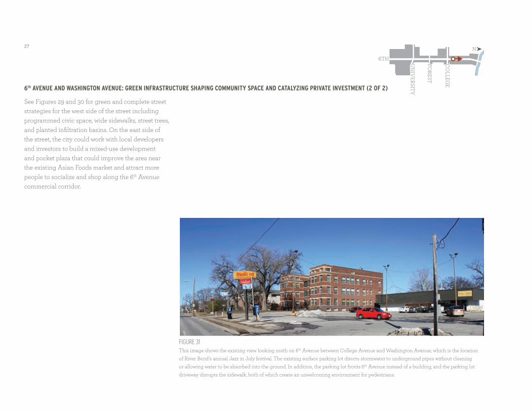
6th Avenue And wAshinGton Avenue: Green infrAstructure shApinG community spAce And cAtAlyzinG privAte investment (2 of 2)
see Figures 29 and 30 for green and complete street strategies for the west side of the street including programmed civic space, wide sidewalks, street trees, and planted infiltration basins. on the east side of the street, the city could work with local developers and investors to build a mixed-use development and pocket plaza that could improve the area near the existing asian Foods market and attract more people to socialize and shop along the 6th avenue commercial corridor.
Figure 31 this image shows the existing view looking north on 6th avenue between College avenue and Washington avenue, which is the location of river Bend’s annual Jazz in July festival. the existing surface parking lot directs stormwater to underground pipes without cleaning or allowing water to be absorbed into the ground. in addition, the parking lot fronts 6th avenue instead of a building, and the parking lot driveway disrupts the sidewalk, both of which create an unwelcoming environment for pedestrians.
6th
Forest
Co
LLege
UN
iVersit
y
N

28
Figure 32 the pocket plaza, new businesses, and residential lofts help shape year-round civic space, dramatically improve the entry to the asian Foods market, and encourage more foot traffic and shopping along the 6th avenue commercial corridor. automobile parking is provided along the street and in a surface parking lot south of asian Foods.

29
6th Avenue And frAnklin Avenue: Green infrAstructure promotinG Art And educAtion
Figure 33
this image shows the existing view looking north on 6th avenue at Franklin avenue. despite the presence of nearby businesses and Moulton
elementary school, 6th avenue lacks crosswalks and other pedestrian amenities that make waiting for the bus or riding a bike more comfortable.
this design concept looking north on 6th avenue at Franklin avenue illustrates how green infrastructure can educate the public about environmental stewardship, civic responsibility, and healthy living. students from the elementary school and high school, both of which are just a few blocks away, could visit this green infrastructure project to monitor how different plants perform or how much runoff the infiltration areas capture.
this concept also illustrates the use of permeable pavers in the sidewalk. these pavers allow more stormwater and snow to percolate into the soil below rather than contributing to the polluted runoff going into the des Moines river. snow melts faster on pavers than on concrete, which prevents ice from forming on sidewalks and keeps pedestrians safer in winter.
6th
Forest
Co
LLege
UN
iVersit
y
N

30
Figure 34 stormwater from the street and parking lot is directed to the landscaped areas where it is absorbed and cleaned by native plants and soils before being released into the underground stormwater pipes. students from nearby schools like Moulton elementary and North high school could use the streetscape infiltration basins as learning laboratories. art, such as the sculpture in the infiltration basin, metal work on the bus shelter and trash can, and bike racks, could be created by local artists and students. sharrows and crosswalks help make walking and biking safe and enjoyable.

31
next steps, key pArtners, And cAse studies
the city of des Moines has a clear priority to encourage and require development that benefits the community and environment as well as the economy. the city has enacted policy changes to support this priority, including zoning strategies and requirements for developers or property owners seeking commercial tax abatement. NPC zoning (Neighborhood Pedestrian Commercial) encourages flexibility in parking counts and reduction of off-street parking through allowing adjacent on-street parking spaces to be counted toward the required parking for the development. there are two small areas of NPC zoning along 6th avenue at College and at Forest. the city has indicated that a more widespread rezoning of the commercial districts along the corridor from mostly C-1 (Neighborhood retail Commercial) to NPC is possible.
recent additions to the city’s tax abatement policy require a developer to incorporate at least four sustainable features as part of their development. developers are provided a list of sustainable features to choose from, ranging from bicycle racks to green roofs. this is a relatively new addition to the city’s tax abatement policy and the office of Planning and Community development has seen positive results citywide since it has gone into effect.
Because of the length of the corridor (approximately 1.2 miles) the city has outlined a phased process for implementation of the design concepts presented in this report. the first phase includes hickman road
to College avenue; phase two would include College avenue to University avenue; and the final phase would include University avenue to interstate 235.
neAr term
in the near term (1-2 years), the city’s plan is to work with 6th avenue Corridor to issue a request for proposals for more detailed design work on the full corridor. during the next two years the city will be conducting site survey work and base construction documents for phase one of the project. some of the survey work has already begun. there is no set budget for the near term but the 6th avenue Corridor has secured some grant funding through the state of iowa and the city has some limited funding for this phase as well. it is also likely that hatch development group will move forward with redeveloping the vacant lot at the northeast corner of Forest avenue.
Near term initiatives and Partners:1. 6th avenue Corridor and the city could explore local public and private partnerships for program and development potential. • establish a prioritized list of mutually
beneficial programs where current gaps exist between partners.
• determine funding sources and incentives from the city.
• determine whether there is support and interest in creating a 6th avenue merchant’s association.
2. 6th avenue Corridor could engage local artists to work with youth of the river Bend and Cheatom Park neighborhoods. this initiative could result in a mural, neighborhood logo, signage, performance, or other projects that build community pride around creative endeavors. Metro arts alliance could work with North high school on this program. 6th avenue Corridor is currently coordinating clean up days with two youth programs in the area.
3. the City of des Moines Parks and recreation department, tree des Moines, and iowa department of transportation’s Living roadways Project could work together to design education programs and encourage private investment in green infrastructure solutions such as rain barrels, rain gardens, downspout disconnection, additional tree planting, and native plant use in gardens and streetscape improvements.
mid term
in the mid-term (3-5 years), the city projects that it will construct phase one of the 6th avenue Corridor streetscape improvements from hickman road to College avenue. the city will also consider the option of burying electrical utilities during this phase. other initiatives outlined below could build upon this public investment for additional community benefits.
Mid term initiatives and Partners:4. 6th avenue Corridor could continue to broker public-private partnerships for housing, retail, and commercial developments that are interested in

32
supporting community goals for walkability, safety, green infrastructure, education, culture, and identity.
5. 6th avenue Corridor could build a communications campaign to advertise this area as the place to live for young professionals, students, families, and retirees. this campaign could focus on the cultural diversity of the area as a place that celebrates the food, dance, music, and arts of the people who live there. the city and local nonprofits could work to support small-business development in the area.
6. des Moines Community development and Public Works could complete street and green infrastructure transformation for phase one of the 6th avenue Corridor.
7. des Moines office of Planning and Community development and the department of Public Works could establish maintenance programs for green infrastructure pilot programs and develop a protocol for citywide green infrastructure implementation and maintenance.
8. des Moines area Community College and evelyn K. davis Center for Working Families could create a new green job training curriculum in coordination with the city’s maintenance programs for green infrastructure.
9. Mercy Medical Center could integrate green infrastructure solutions into their property to reduce the amount of stormwater runoff from their buildings and surface parking lots. Mercy Medical Center could also contribute to an educational campaign
by contributing signage throughout the corridor to describe the health benefits of street improvements and green infrastructure strategies.
10. 6th avenue Corridor could help the neighborhood associations to create a development committee of neighborhood leaders to receive training in development and zoning processes. this group could learn how to advocate for achieving the high standards of performance their neighborhoods have envisioned for future development. as this group becomes more knowledgeable on smart growth and green infrastructure practices, they could advise the city on new policy or programs needed to support sustainable development in their neighborhoods.
lonG term
in the long term (5-10 years), the city plans to complete construction of phases two and three of the 6th avenue streetscape improvements, which includes improvements from College avenue to University avenue and University avenue to interstate 235). other initiatives outlined below could build upon the potential of this public infrastructure investment to stimulate new development interest in the area.
Long term initiatives and Partners:11. 6th avenue Corridor and des Moines office of Planning and Community development could coordinate appropriate infill development along 6th avenue.
• hatch development group could be an ongoing development partner if their current investments at Forest avenue and north of Forest avenue thrive.
• anawim housing could be a potential partner for housing and mixed use development.
• NeighborWorks could be a potential partner for housing development and facilities for community service providers.
• Mercy Medical Center could be a partner in developing facilities and/or programs for a community health center including training on fitness, food, and the importance of active lifestyles.
12. the city could establish additional bike routes and walking paths to compliment accessible sidewalks and pedestrian amenities.
13. the city Parks and recreation department could dedicate a new neighborhood park and gathering place for community cultural events and performances.
14. if a 6th avenue Corridor merchant’s association is formed in the near-term or mid-term, this association may determine that it would be beneficial to form a Community improvement district (Cid) or Neighborhood improvement district (Nid) if the tax base has increased enough to make this feasible and beneficial for local businesses.

33
cAse study 1: mAin street Green infrAstructure pilot project
GreensburG, kAnsAs
the Main street green infrastructure Pilot Project was one of the first major infrastructure projects in greensburg after an eF-5 tornado destroyed the majority of the town in 2007. this pilot project tested a number of sustainable systems which were then implemented throughout the rebuilding of the town.
the new greensburg Main street incorporates stormwater management techniques, innovative material use, and energy efficiency measures. all components are environmentally sustainable, including planting and irrigation, seating, and paving materials.
one of the primary community goals is to celebrate stormwater as a precious resource, and this design highlights the place of stormwater in the public realm. runoff from building roofs, sidewalks, and streets is collected in underground cisterns, cleansed of sediment and heavy metals within integrated infiltration basins, and reused for irrigation during drought conditions. the design encourages recharge of the aquifer and promotes environmental stewardship through low maintenance solutions.
cAse study 2: stormwAter As neiGhborhood reinvestment
middle blue river Green solution in kAnsAs city, missouri
repairing the aging infrastructure within the 6th avenue Corridor could be an opportunity to integrate green technology and strategies, and to address neighborhood concerns for safe and continuous sidewalks, just as the Middle Blue river green solution Pilot Project did in Kansas City, Missouri.
Kansas City implemented the first phase of the Middle Blue river green solution Pilot Project as part of requirements to separate and reduce combined sewer overflows. the project focused on a single watershed of the Middle Blue river, in an historic neighborhood. the project reduces the overflows with more than 150 stormwater solutions, including pervious pavements, rain gardens, and basins that slow and filter stormwater through plants. While the engineering team was building the stormwater infrastructure, the neighborhood residents told the city that they needed sidewalks in order for pedestrians to safely walk to their transit stops. in response, the design team and the city created strategies that not only captured stormwater, but created a new route of connected sidewalks.
the following case studies illustrate successful implementation of green infrastructure projects and some of the resulting benefits to their communities.

34

35