ground-water levels in south carolina u.s. geological survey ... range from mean sea level at the...
TRANSCRIPT

i
GROUND-WATER LEVELS IN
SOUTH CAROLINA
A Compilation of Historical Water-Level Data
by
Karen E. Waters
STATE OF SOUTH CAROLINADEPARTMENT OF NATURAL RESOURCES
WATER RESOURCES REPORT
2003

ii
STATE OF SOUTH CAROLINAThe Honorable Mark Sanford, Governor
South Carolina Department of Natural Resources
Board Members
Dr. Joab M. Lesesne, Jr., Chairman . . . . . . . . . . . . . . . . . . . . . . . . . . 4th Congressional District
Dr. Julius L. Leary, Vice Chairman . . . . . . . . . . . . . . . . . . . . . . . . . . 3rd Congressional District
Danny L. Ford . . . . . . . . . . . . . . . . . . . . . . . . . . . . . . . . . . . . . . . . . Member-at-Large
Ms. M. Russell Holliday, Jr. . . . . . . . . . . . . . . . . . . . . . . . . . . . . . . 1st Congressional District
Ben Gregg . . . . . . . . . . . . . . . . . . . . . . . . . . . . . . . . . . . . . . . 2nd Congressional District
Dr. Douglas A. Rucker . . . . . . . . . . . . . . . . . . . . . . . . . . . . . . . . 5th Congressional District
D. Malloy McEachin, Jr. . . . . . . . . . . . . . . . . . . . . . . . . . . . . . . . 6th Congressional District
John E. Frampton, Director
Land, Water and Conservation Division
Alfred H. Vang, Deputy Director
A.W. Badr, Ph.D., Chief, Hydrology Section

iii
CONTENTS
Page
Abstract . . . . . . . . . . . . . . . . . . . . . . . . . . . . . . . . . . . . . . . . . . . . . . . . . . . . . 1
Introduction . . . . . . . . . . . . . . . . . . . . . . . . . . . . . . . . . . . . . . . . . . . . . . . . . . . 1
Physiography . . . . . . . . . . . . . . . . . . . . . . . . . . . . . . . . . . . . . . . . . . . . . . . 1
Climate . . . . . . . . . . . . . . . . . . . . . . . . . . . . . . . . . . . . . . . . . . . . . . . . . . 1
Previous investigations . . . . . . . . . . . . . . . . . . . . . . . . . . . . . . . . . . . . . . . . . . 3
History of ground-water monitoring in South Carolina . . . . . . . . . . . . . . . . . . . . . . . . . . . . . 3
Aquifer nomenclature . . . . . . . . . . . . . . . . . . . . . . . . . . . . . . . . . . . . . . . . . . . . . . 3
Data collection and compilation . . . . . . . . . . . . . . . . . . . . . . . . . . . . . . . . . . . . . . . . 7
Water use . . . . . . . . . . . . . . . . . . . . . . . . . . . . . . . . . . . . . . . . . . . . . . . . . . . . 7
Explanation of hydrographs . . . . . . . . . . . . . . . . . . . . . . . . . . . . . . . . . . . . . . . . . . . 7
Signifi cant fi ndings . . . . . . . . . . . . . . . . . . . . . . . . . . . . . . . . . . . . . . . . . . . . . . . 7
References . . . . . . . . . . . . . . . . . . . . . . . . . . . . . . . . . . . . . . . . . . . . . . . . . . . 12
List of wells for which hydrographs are presented . . . . . . . . . . . . . . . . . . . . . . . . . . . . . . 13
FIGURES
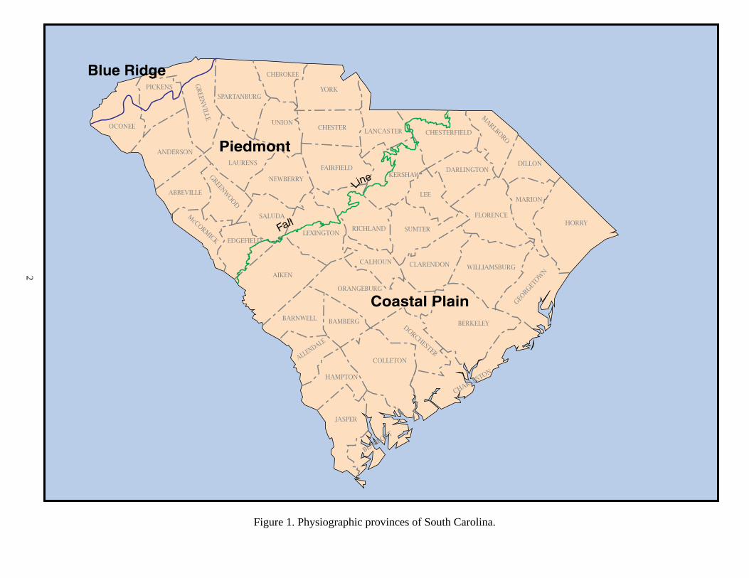
1. Physiographic provinces of South Carolina . . . . . . . . . . . . . . . . . . . . . . . . . . . . . . . 2
2-4. Graphs showing average annual precipitation for the physiographic provinces:
2. Blue Ridge . . . . . . . . . . . . . . . . . . . . . . . . . . . . . . . . . . . . . . . . . . . . . . 4
3. Piedmont . . . . . . . . . . . . . . . . . . . . . . . . . . . . . . . . . . . . . . . . . . . . . . . 5
4. Coastal Plain . . . . . . . . . . . . . . . . . . . . . . . . . . . . . . . . . . . . . . . . . . . . . 6
5-7. Maps showing locations of wells for which hydrographs are presented:
5. Northwestern South Carolina . . . . . . . . . . . . . . . . . . . . . . . . . . . . . . . . . . . . . 8
6. Northeastern South Carolina . . . . . . . . . . . . . . . . . . . . . . . . . . . . . . . . . . . . . 9
7. Southern South Carolina . . . . . . . . . . . . . . . . . . . . . . . . . . . . . . . . . . . . . . 10

1
INTRODUCTION
The U.S. Geological Survey (USGS) and the Soil Con ser va tion Ser vice, U. S. Department of Agriculture, fi rst made periodic water-level measurements at 28 wells in the Tiger River valley area in Greenville and Spartanburg Counties during 1932. It was not until 1945, however, that a systematic well-monitoring program was established by the USGS and the South Carolina Research, Plan ning and Development Board. In this program, water-level measurements were made periodically in 15 wells scattered through out the Coastal Plain. Beginning in 1946, water-level mea sure ments for the State were published annually as part of a na tion wide program. Wells were sub se quent ly added or deleted, and data became re fi ned with time. The USGS now publishes “Water Resources Data for South Carolina” annually and includes data from both surface-water and ground-water monitoring stations.
More than 54 years of data from various sources have been compiled, reviewed, and prepared as hydrographs for this pub- lication. Although data have been published previously in an annual format, never before have records been collected, com bined, and pre sent ed by county, for the available period of record. In this publication, data from 282 wells, 266 in the Coastal Plain and 16 in the Piedmont, have been compiled and graphed. For about one-third of the 282 wells, data are available for a period of 20 years or more; 14 well records contain data for 40 years or more, and half of these wells are in Beaufort County. The overall period of record for the data presented is from 1938 to 2002, with the longest records represented by well BFT-37 in Beaufort County (1941-1994) and well JAS-1 in Jasper County (1938-1993).
These data provide information needed for monitoring ground-water conditions in South Carolina and planning future man age ment and conservation programs. By observing ground-water fl uctuations and trends, changes in aquifer storage can be de ter mined and used as an indication of the status of ground-water con di tions, thus better enabling the State to understand, manage, and protect one of its most critical resources.
Physiography
South Carolina covers an area of more than 30,000 square miles and is divided into three physiographic provinces (Fig. 1). A small area along the northwestern boundary of the State lies in the Blue Ridge physiographic province. The Piedmont phys i o graph ic province occupies the area between the Blue Ridge province and the Fall Line, and the area between the Fall Line and the Atlantic Ocean constitutes the Coastal Plain phys i o graph ic province.
The Blue Ridge and Piedmont provinces are composed of ig ne ous and metamorphic rocks, mostly gneiss, schist, phyllite, and slate. Elevations are as high as 650 ft above sea level at the Fall Line and over 3,500 ft in the Blue Ridge.
The Coastal Plain province consists of variations of sand, clay, and limestone that overlie the Piedmont rocks. Elevations range from mean sea level at the coast to as much as 650 ft at the Fall Line.
Climate
The climate of South Carolina differs signifi cantly among the three physiographic provinces, ranging from humid subtropical along the coast to cool and temperate in the moun tains. On average, however, South Carolina has short, rather mild winters and long, hot summers.
Figures 2-4 show the average annual precipitation for each physiographic province from 1935 to 2001, with the exception of the Blue Ridge, where data are available only since 1949. A pink line represents the mean, while yellow and blue lines represent one standard deviation above and below the mean, respectively, and are shown to give the reader an idea of high and low extremes during this time period. The average annual pre cip i ta tion for the Blue Ridge, Piedmont, and Coastal Plain provinces is 68.6, 47.1, and 47.6 inches, respectively.
Precipitation in the State can vary signifi cantly from year to year and throughout the year. For example, the Blue Ridge province
GROUND-WATER LEVELS IN SOUTH CAROLINAA Compilation of Historical Water-Level Data
byKaren E. Waters
ABSTRACT
More than 54 years of data from various sources have been compiled, reviewed, and prepared as hydrographs for this publication. These hydrographs show water-level trends in 282 South Carolina wells, 266 in the Coastal Plain physiographic province and 16 in the Piedmont. For approximately one-third of the wells, data are available for a period of 20 years or more; 14 well records contain data for 40 years or more, and 7 of these wells are in Beaufort County. JAS-1, a well located in southeastern Jasper County, has the longest period of record – more than 50 years.
Wells in several counties have pronounced ground-water level declines or fl uctuations. Water levels in the Floridan aquifer in Hampton County show distinct highs in the spring and lows in the fall, probably a result of recharge from precipitation or of local seasonal pumping. Water-level records for the Black Creek aquifer in northern Georgetown County show an average decline of nearly 60 feet since the mid-1970's. Well records for the Black Creek aquifer in Horry County demonstrate the most dramatic decline and recovery over the period of record. Declines as great as 110 feet were recorded through the 1970's and 1980's. Between 1988 and 1992, major public water suppliers in Horry County discontinued well use and began using surface water, thus facilitating regional water-level recoveries as great as 100 feet.
2
Figure 1. Physiographic provinces of South Carolina.
Piedmont
Coastal Plain
Blue Ridge
Fall
Line
CHESTERFIELD
DARLINGTON
HORRYFLORENCE
LEE
DORCHESTER
SUMTERRICHLANDLEXINGTON
CALHOUN
ORANGEBURG
CLARENDON
CHAR
LESTO
N
BERKELEY
WILLIAMSBURG
GEORG
ETOW
N
FAIRFIELDKERSHAW
YORK
CHESTER LANCASTER
COLLETON
JASPER
BEAU
FORT
OCONEE
PICKENS
ANDERSON
GREEN
VILLE
CHEROKEE
UNION
GREENWOOD
McCORM
ICK EDGEFIELD
SALUDA
LAURENS
ABBEVILLE
NEWBERRY
AIKEN
BARNWELL BAMBERG
HAMPTON
ALLEN
DALE
SPARTANBURG
MARLBORO
DILLON
MARION

3
continued to experience drought conditions during 1987 while the Piedmont and Coastal Plain received additional rainfall from seasonal storms that alleviated any signifi cant rainfall defi cits. The years 1925, 1954, 1986, and the period from June 1998 to the pres-ent are considered major periods of drought in South Caro li na. The droughts of 1925 and 1954 are con sid ered the worst and second-worst, respectively, in the 20th century. Like the present drought (1988 to present), La Niña precipitated the drought of 1954. To date, many of the low-streamfl ow measurements made throughout the State in 1954 have already been surpassed. The current drought possibly will exceed the second-worst drought on record. (M. E. Brown, State Cli ma tol o gist, per son al commun., 2002).
Previous Investigations
The USGS has published annual reports on ground-water levels in South Carolina since 1942. They include USGS Water-Sup ply Papers 945, 987, 1024, 1072, 1097, 1127, 1157, 1166, 1192, 1222, 1266, 1322, 1405, 1538, 1803, 1978, and 2171 for the years 1942-1973. Siple (1946 and 1957b) provided useful publications on ear ly in ves ti ga tions of the ground-water resources of South Carolina. Aucott and Speiran (1984) pro duced water-level estimates for the Coastal Plain aquifers prior to development, as well as completing several investigations related to the potentiometric surfaces of aquifers in the Coastal Plain (1985a and 1985b). Other po ten ti o met ric maps include those by Stringfi eld and Campbell (1993) and Ransom and White (2000).
The South Carolina Department of Natural Resources (SCDNR), Land, Water and Conservation Division, and its predecessor agency, the South Caro li na Wa ter Re sourc es Commission, have published sev er al reports con cern ing wa ter-lev el mea sure ments and po ten ti o met ric maps for local and re gion al areas of the Coast al Plain. These include Crouch and others (1985 and 1987), Davies (1985), Meadows (1987), Whit ing and Park (1990), Gawne (1990 and 1994), Hockensmith (1997 and 2001), and Hockensmith and Waters (1998).
HISTORY OF GROUND-WATER MONITORING IN SOUTH CAROLINA
In 1939, a ground-water monitoring program was begun in Beaufort and Jasper Counties to document the effects of heavy pump ing at Savannah, Ga. (USGS Water-Supply Paper 987, 1943). This investigation was led by the USGS in cooperation with the Georgia State Division of Conservation, Department of Mines, Plan ning, and Geology. Fourteen measurements were obtained in nine wells in Beaufort and Jasper Counties by the end of 1942; however, owing to extreme drought conditions, monitoring was discontinued in 1943 (USGS Water-Supply Paper 987, 1943). These data were not included in the present report because correlation with existing SCDNR observation wells was not possible and because of a lack of essential data such as casing diameter, depth, screen intervals, and exact well locations.
Another ground-water monitoring program began in the Tiger (modern spelling is Tyger) River valley area in Greenville and Spartanburg Counties in 1934 and continued until 1942. The USGS, working in cooperation with the Soil Conservation Service of the U.S. Department of Agriculture, made mea sure ments in 28 wells screened in alluvial aquifers. This program was affected by drought, and by 1942 all but three of these wells had gone dry and measurements were discontinued (USGS Water-Supply Paper 945, 1942).
By 1946, the USGS, in cooperation with the South Caro li na Research, Planning and Development Board, began a sys tem at ic program of ground-water monitoring that included a total of 15 observation wells: 13 in the Coastal Plain and 2 in the Piedmont (USGS Water-Supply Paper 1072, 1946). The well-monitoring program continued, and data were published for various wells in South Carolina from 1946 through 1955 in USGS Water-Supply Papers 1072, 1097, 1127, 1157, 1166, 1192, 1266, 1322, and 1405 as Water Levels and Artesian Pressures in Observation Wells in the United States in 19**. Part 2, Southeastern States. In 1955, the name of the publication changed to Ground-Water Levels in the US, 19**-**. South east ern States. By 1973 another change was made, and Water Resources Data were published on an annual basis, spe cifi cal ly for South Carolina. The same format is presently in use. Periodically, other agencies publish water-level data, but none with long periods of records as consistently as the USGS.
To identify the wells, the original numbering system con sist ed of a number assigned in the order in which the well was catalogued and a name, usually the well owner. Latitude and lon gi tude were introduced in the 1951 report, and by 1959 the USGS had changed its well identifi cation format by com bin ing the lat i tude, the letter N for North, the longitude and a number that represented the well as it was catalogued. Local numbers continued to be used. In 1969, both the letter N and the catalogue number were discontinued. The principal well-numbering system became the latitude and lon gi tude along with the local well number, currently in use. Well names and identifi cation numbers did not always stay the same, resulting in some confusion; consequently, not all of the USGS historical well data could be used in this report.
AQUIFER NOMENCLATURE
With the exception of the 16 wells located in the Piedmont province, aquifer nomenclature was determined by using the geo hy dro log ic framework of Aucott, Davis, and Speiran (1987).
Six aquifer systems were defined and are summarized below:
1. The surfi cial aquifer, also considered the water-table aquifer, is generally less than 40 ft thick and is lo cat ed in the lower Coastal Plain. It overlies the Floridan aquifer in the south ern coun ties and the Black Creek aqui fer in the southeastern counties.
2. The Floridan aquifer can be as thick as 1,400 ft, and it consists of parts of the Cooper, Ocala, and Santee Formations. This aquifer is found only in south ern and southwestern areas of the Coastal Plain and overlies the lower part of the Tertiary sand aquifer.
3. The Tertiary sand aquifer is as much as 1,400 ft in thickness and consists of an upper and lower sec tion. The upper section is the updip sand equiv a lent of the limestone that com pos es the Floridan sys tem. It includes the Barnwell, McBean, and Congaree For ma tions and lies between the Fall Line and the updip limit of the Floridan aquifer. The lower section is com posed of early Eocene and Paleocene sed i ments and un der lies the up per sec tion of the Tertiary sand aqui fer and all of the Floridan aquifer. It covers the majority of the Coastal Plain and overlies the Black Creek formation.

4
Figure 2. Average annual precipitation for the Blue Ridge province.

5
Figure 3. Average annual precipitation for the Piedmont province.

6
Figure 4. Average annual precipitation for the Coastal Plain province.
7
EXPLANATION OF HYDROGRAPHS
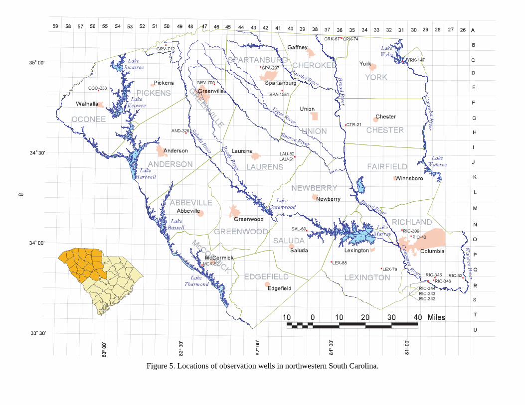
Hydrographs are presented by county. For each well the fol low ing are given: identifi cation numbers, location, aquifer name, well construction, period of record, and extremes of record. The well-numbering system includes a three-character ab bre vi a tion for the county name followed by a number that represents the chronological order in which the well record was obtained; for example, AIK-183. In addition, SCDNR uses a grid-location sys tem in which each grid division corresponds to 5 minutes of latitude and lon gi tude. An upper-case letter signifi es the latitude grid and a number signifi es the longitude grid. (See Figs. 5-7.) To further pinpoint the well, the 5-minute grid is divided into 1-minute grids rep re sent ed by the lower-case letters a through y. Wells in that 1-minute grid are numbered consecutively as their records are ob tained. The grid number for AIK-183 would be 41V-x3.
The measurement datum for each well is based on the National Geo det ic Vertical Da tum of 1929 and has either been sur veyed, in which case it will be shown as a precise mea sure ment (as 12.12 ft), or estimated from a to po graph ic map (as 12 ft). Maps used to de ter mine elevations are USGS topographic quad ran gles with a scale of 1:24,000 and contour intervals of 5, 10, or 20 ft or of 1.5 meters.
For each well, the header information is followed by two graphs. The fi rst graph plots the period of record for each well, using the fi rst and last days of the calendar years in which the measurements were made. The second graph plots data on a standard horizontal scale starting in 1940 and ending in 2010. Where feasible, a 20-ft scale with 5-ft intervals was used for the vertical axis. For both graphs, water levels are relative to land surface on the left vertical scale and relative to sea level on the right vertical scale. Several wells have water levels above land surface.
Two types of water-level data are illustrated on the hydrographs: 1) those that were recorded on a continuous basis by use of automatic recorders, and 2) those that were measured intermittently with steel or electric tapes. A solid line represents data recorded continuously and a hollow circle connected by a solid line represents intermittent measurements.
SIGNIFICANT FINDINGS
In this data set, 26 wells (9 percent) are open to the Middendorf aquifer. Historically, substantial water-level declines have been observed in Middendorf wells in Berkeley, Charles ton, and Florence Counties. Some of the greatest declines are listed below:
• BRK-431, near Moncks Corner, had a decline of nearly 40 ft from 1989 to 2000.
• CHN-14, in downtown Charleston, had a decline of nearly 80 ft from 1990 to 2000.
• FLO-128 and FLO-129, near the Great Pee Dee River, have 18- and 13-year records, respectively, and had water-level declines of 37 and 21ft. Hockensmith and Wa ters (1998) discussed, in de tail, the his tor i cal trends of this aquifer.
Of the wells in this report, 68 (24 percent) are open to the Black Creek aquifer. Charleston, Georgetown, Horry, and Florence Coun ties have had the most signifi cant historical water-level declines. Wells CHN-64, in downtown Charleston, and CHN-182, on the northeastern boundary of the county at Hampton Plantation, had consistent declines of more than 30 ft for the periods of 1990 to 1992 and 1986 to 2001, respectively. Most of the observation wells in Georgetown County have undergone water-level declines of 13 to 100 ft, with the longest record being 30 years. Wells located
4. The Black Creek aquifer has a thickness of 1,000 ft or less and comprises the Black Creek Formation and parts of the overlying and underlying units. This aquifer extends along the entire lower Coastal Plain and crops out in the eastern section of the upper Coastal Plain. The Black Creek aquifer over lies the Middendorf aquifer.
5. The Middendorf aquifer can be as thick as 800 ft and comprises the Middendorf Formation. This aqui fer occurs through out the Coastal Plain and crops out adjacent to the Fall Line. It overlies the Cape Fear aquifer in the middle and lower Coastal Plain and crys tal line bedrock in the up per Coastal Plain.
6. The Cape Fear aquifer is not well defi ned, and in for ma tion is sparse regarding its thickness and areal extent, but a range in thick ness of 0 to 800 ft is indicated. The aquifer involves only the Cape Fear For ma tion, and there is no known outcrop. This aquifer over lies Pre-Cre ta ceous ig ne ous and meta mor phic rocks.
DATA COLLECTION AND COMPILATION
Nearly half of the 282 wells whose hydrographs are pre sent ed in this report have, for some period of their record, continuous daily measurements; the remaining wells have intermittent measurements. The spatial distribution of data is irregular, abun dant in some counties and missing in others. For counties with nu mer ous observation wells, the ones in this report were selected on the basis of length of record, number of measurements, location, and aquifer. Figures 5 through 7 show locations of wells. The selected wells had either one full year of continuous data or at least four intermittent measurements over a minimum period of three years. Also, a maximum of two wells per aquifer were chosen to represent numerous wells located within the same 1-minute degree of lat i tude and longitude. Water-level measurements were compiled and presented as depth to water from land surface and as elevation of water level above or below mean sea level (estimated where land surface elevation had to be obtained from topographic maps.)
Data were collected from various sources, such as State agen cies and miscellaneous publications; however, the majority of mea sure ments were obtained from SCDNR and USGS fi les and publications.
WATER USE
Although South Carolina relies heavily on surface water as a source of public supply, 99 mgd (million gallons per day) were obtained from wells in 2000. This is about 18 percent of the total used for public supply. More than half of the 300 largest mu nic i pal i ties and water authorities rely on wells. In addition, ground water provides about 64 mgd for rural domestic use, 57 mgd for industrial use, 190 mgd for crop irrigation, and 25 mgd for golf-course irrigation (oral comm., J.E. Castro, 2002).
Ground water has always been an important source of water for South Carolina. In the mid-1940's, it supplied 115 of the State’s 166 public water-supply systems. About 98 percent of the rural population obtained water from wells and, although no spe cifi c fi gure was provided for industrial use, Siple (1946) inferred that a large portion of that supply came from ground water. In the year 2000, ground water was the only source of water supply for one-third of the State’s population.
8
Figure 5. Locations of observation wells in northwestern South Carolina.

9
Figure 6. Locations of observation wells in northeastern South Carolina.

10
Figure 7. Locations of observation wells in southern South Carolina.

11
near Litchfi eld and Murrells Inlet had signifi cant declines with an av er age of nearly 60 ft since the mid-1970's. GEO-193, near the town of Andrews, had the greatest water-level decline, 101 ft from 1988 to 2001. Dur ing the last 5 years, however, the water level in this well has risen about 40 ft.
Most of Horry County discontinued using ground water and began using surface water between 1988 and 1992 because of sub stan tial water-level declines in the Black Creek aquifer. During the 1970's and 1980's, water levels showed seasonal pumping effects and overall declines of 50-110 ft (Hockensmith, 1997). Throughout the 1990's, many wells showed regional recovery of the aquifer, with water levels rising as much as 100 feet (where data were available). One well, HOR-321, near the center of the cone of depression, shows both the decline and subsequent recovery.
A well in Marion County, MRN-77, near Brittons Neck Fire Tower, showed a steady decline in water levels of more than 30 ft from 1982 to 2000.
About half of the wells in this publication are open to the Tertiary sand and Floridan aquifers. Seasonal fl uctuations are evident in most wells, as are tidal fl uctuations in the coastal coun ties. Water levels in the Floridan aquifer in Hampton County show dis tinct highs in the spring and lows in the fall, probably a result of recharge from precipitation or effects of local seasonal pumping. Most of the well data show no dramatic declines for the deeper aquifers; however, slight declines were observed in Beaufort Coun ty where water levels in some wells fell 20 ft or less. Over the past 15-20 years, wells monitored in Charleston County had an average decline of 13 ft. A more comprehensive summary of his tor i cal trends regarding this aquifer has recently been pub lished by Hockensmith (2001).
There are 24 observation wells in the surfi cial aquifer. Water-levels in these wells are subject to precipitation fl uc tu a tions, sea sonal evaporative and transpiration demands, and sur face- water stage effects. Often these wells can be used as local drought- index wells.
Sixteen observation wells are located in the Piedmont and Blue Ridge provinces. They range in depth from 80 to 800 ft. These wells obtain their water from fractures that pen e trate the crys tal line rocks, but the water levels often refl ect sea son al fl uc tu a tions.
In summary, historical data for 282 wells have been col lect ed and compiled in graphical form to provide an overall picture of the status of ground-water levels in South Carolina. Although not spatially exhaustive, these data are fairly com pre hen sive and may be used by South Carolina natural-resource stewards to man age and protect this vital resource.

12
_____, 2001, Water-level measurements used in construction of the 1998 potentiometric map for the Floridan aquifer in South Carolina: South Carolina Department of Natural Resources Water Resources Division Open-File Report 6, 23 p.
Hockensmith, B.L., and Waters, K.E., 1998, Potentiometric surface of the Middendorf aquifer in South Carolina – November 1996: South Carolina Department of Natural Resources Water Resources Division Report 19, 1 sheet.
Hockensmith, B.L., 1997, Potentiometric surface of the Black Creek aquifer in South Carolina – November 1995: South Carolina Department of Natural Resources Water Resources Division Report 16, 1 sheet.
Newcome, Roy, Jr., 1989, Ground-water resources of South Caro li na’s Coastal Plain: 1988 – an overview: South Carolina Water Resources Commission Report 167, 127 p.
Park, A.D., 1985, The ground-water resources of Charleston, Ber ke ley, and Dorchester Counties, South Carolina: South Carolina Water Resources Commission Report 139, 146 p.
Ransom, Camille, III, and White, J.L., 2000, Potentiometric surface of the Floridan aquifer system in southern South Carolina, September 1998: South Carolina Department of Health and Environmental Control Pub li ca tion 02B-99, 1 plate.
Siple, G.E., 1946, Progress report on ground-water in ves ti ga tions in South Carolina: South Carolina Research, Planning and Development Board Bulletin No. 15, 116 p.
_____1957b, Ground water in the South Carolina Coastal Plain: Journal of the American Water Works Association, v. 49, no. 3, p 283-300.
South Carolina Water Resources Commission, 1983, State water assessment: South Carolina Water Resources Com mis sion Report 140, 367 p.
Stringfi eld, W.J., and Campbell, B.G., 1993, Potentiometric surfaces of November 1989 and declines in the po ten ti o met ric sur fac es between November 1982 and November 1989 for the Black Creek and Middendorf aqui fers in South Carolina: U.S. Geological Survey Water-Re sourc es Investigations Report 92-4000, 2 sheets.
Whiting, N.M., and Park, A.D., 1990, Preliminary In ves ti ga tion of water-level declines in wells near Estill, Hampton County, South Carolina, spring 1990: South Carolina Water Resources Commission Open-File Report 37, 18 p.
U.S. Geological Survey, 1942-1943 and 1945-1955, Water levels and artesian pressures in observation wells in the United States, Part 2, Southeastern States: Water-Sup ply Papers 945, 987, 1024, 1072, 1097, 1127, 1157, 1166, 1192, 1222, 1266, 1322, and 1405 (published annually).
U.S. Geological Survey, 1956-1973, Ground-water levels in the Unit ed States, Southeastern States: Water-Supply Papers 1538, 1803, 1978, and 2171 (published every 5 years).
U.S. Geological Survey, 1974-2000, Water Resources Data- South Carolina, Water Year 1974….2000: Water Data Reports SC-74-1 through SC-01-1 (published annually).
REFERENCES
Aucott, W. R., 1996, Hydrology of the south east ern Coastal Plain aquifer system in South Carolina and parts of Georgia and North Carolina: U.S. Geological Survey Professional Paper 1410-E, 83 p.
Aucott, W.R., Davis, M.E., and Speiran, G.K., 1987, Geo hy dro log ic framework of the Coastal Plain aquifers of South Carolina: U.S. Geological Survey Water-Resources In ves ti ga tions Report 85-4271, 7 sheets.
Aucott, W.R., and Speiran, G.K., 1985a, Potentiometric surfaces of November 1982 and declines in the po ten ti o met ric sur face between the period prior to development and November 1982 for the Coastal Plain aquifers of South Carolina: U.S. Geological Survey Water-Resources In ves ti ga tions Report 85-4215, 7 sheets.
______, 1985b, Potentiometric surfaces of the Coastal Plain aquifers of South Carolina prior to development: U.S. Geo log i cal Survey Water-Resources Investigations Report 84-4208, 5 sheets.
_____, 1984, Water-level measurements for the Coastal Plain aquifers of South Carolina prior to development: U.S. Geo log i cal Survey Water-Resources Investigations Report 84-803, 36 p, 1 sheet.
Castro, J.E., Hockensmith, B.L., and Curley, R.E., 1995, Aquifer storage and Recovery – Myrtle Beach, South Carolina, Phase I: Feasibility study – A Hydrologic In ves ti ga tion: South Carolina Department of Natural Resources Water Resources Division Report 4, 51 p, 2 plates.
Castro, J.E., and Foster, J.R., 2000, Distribution and rate of water use in South Carolina: South Carolina Department of Natural Resources Hydrology/Geology Map 4.
Cooke, C.W., 1936, Geology of the Coastal Plain of South Carolina: U.S. Geological Survey Bulletin 867, 196 p.
Cresler, A.M., 2000, Ground-water conditions in Georgia, 1999: U.S. Geological Survey Open-File Report 00-151, 171 p.
Crouch, M.S., Hughes, W.B., Logan, W.R., and Meadows, J.K., 1987, Potentiometric surface of the Floridan aquifer in South Carolina, July 1986: South Carolina Water Resources Commission Report 157, 1 plate.
Gawne, C.E., 1990, Potentiometric surface of the upper Floridan aquifer, Beaufort, Hampton, and Jasper Counties, South Caro li na; March and July 1990: South Carolina Water Resources Commission Open-File Report 38, 16 p.
_____, 1994, Water-level measurements and potentiometric maps for 1991-1993, Beaufort, Colleton, Hampton, and Jasper Counties, South Carolina, with selected hydrographs for 1975-1993: South Carolina Water Resources Com mis sion Open-File Report 43, 20 p., 11 plates.
Hockensmith, B.L., 2001, Potentiometric map of the Floridan aquifer and Tertiary sand aquifer in South Carolina, 1998: South Carolina Department of Natural Re sourc es Water Re sourc es Division Report 23, 1 sheet.

13
WELLS FOR WHICH HYDROGRAPHS ARE PRESENTED
COUNTY NO. LATITUDE LONGITUDE GRID NO. PERIOD AQUIFER PAGE NO.AIKEN AIK-183 332555 815315 41V-x3 1952-1998 Middendorf 19AIK-430 331940 814435 39X-e1 1952-2000 Middendorf 20AIK-467 331705 813915 38X-o1 1951-1981 Tertiary sand 21AIK-468 331320 814405 39Y-f1 1953-1973 Tertiary sand 22AIK-817 332615 814612 40V-s2 1988-2000 Middendorf 23AIK-818 332615 814612 40V-s3 1988-2000 Middendorf 24AIK-824 332616 814615 40V-s5 1993-2000 Black Creek 25AIK-825 332616 814614 40V-s6 1989-2000 Black Creek 26AIK-826 333230 812905 36U-01 1989-2000 Middendorf 27AIK-845 333232 812908 36U-o2 1993-2000 Middendorf 28AIK-846 333232 812908 36U-o3 1993-2000 Black Creek 29AIK-847 333232 812908 36U-o4 1993-2000 Black Creek 30AIK-848 333232 812908 36U-o5 1993-2000 Black Creek 31AIK-849 333232 812908 36U-o6 1993-2000 Tertiary sand 32
ALLENDALEALL-7 325725 811410 33BB-o8 1946-1966 Tertiary sand 33ALL-347 330128 812302 35AA-q2 1993-1995 Middendorf 34ALL-348 330130 812304 35AA-q3 1993-1995 Cape Fear 35
ANDERSON AND-326 343714 822856 48H-n2 1993-2000 Piedmont rock 36
BARNWELLBRN-14 331431 812121 35Y-b11 1948-1968 Tertiary sand 37BRN-78 332358 812520 36W-j1 1981-1992 Middendorf 38BRN-97 331449 812753 36Y-c4 1977-1979 Black Creek 39BRN-102 331531 812606 36X-x17 1977-1985 Black Creek 40BRN-150 331449 812753 36Y-c11 1977-1979 Tertiary sand 41BRN-151 331519 812606 36X-v1 1977-1985 Tertiary sand 42BRN-154 331531 812606 36X-v2 1977-1985 Tertiary sand 43BRN-155 331531 812606 36X-v3 1979-1985 Tertiary sand 44BRN-349 331044 811851 34Y-x1 1988-2000 Middendorf 45BRN-350 331044 811851 34Y-x2 1988-2000 Tertiary sand 46BRN-351 331044 811851 34Y-x3 1988-2000 Tertiary sand 47BRN-352 331044 811851 34Y-x4 1989-2000 Tertiary sand 48BRN-353 331043 811854 34Y-x5 1989-2000 Black Creek 49BRN-354 331044 811854 34Y-x6 1989-2000 Tertiary sand 50BRN-355 331044 811855 34Y-x7 1989-2000 Black Creek 51BRN-356 331043 811856 34Y-x8 1989-2000 Middendorf 52BRN-358 331916 812424 35X-e2 1993-1999 Middendorf 53BRN-359 331916 812428 35X-e3 1989-1999 Tertiary sand 54BRN-360 331915 812427 35X-e4 1989-1999 Tertiary sand 55BRN-365 331916 812424 35X-e5 1993-1999 Black Creek 56BRN-366 331916 812424 35X-e6 1993-1999 Middendorf 57BRN-367 331916 812424 35X-e7 1993-1999 Tertiary sand 58BRN-368 331916 812424 35X-e8 1993-1999 Black Creek 59
BEAUFORT BFT-37 323144 804602 28GG-s1 1941-1994 Floridan 60BFT-101 321005 804427 27KK-y1 i1955-2000 Floridan 61 BFT-116 323144 804602 28HH-t3 1957-1986 Floridan 62BFT-121 322748 804405 27HH-o1 1955-1998 Floridan 63BFT-133 323120 804305 27GG-q1 1957-1998 Floridan 64BFT-154 322219 805106 29II-l2 1956-1998 Floridan 65BFT-216 323550 804743 28FF-w1 1975-1990 Floridan 66BFT-222 321241 805156 29KK-l1 1955-1993 Floridan 67BFT-304 320846 805022 29LL-j1 1958-1994 Floridan 68

14
COUNTY NO. LATITUDE LONGITUDE GRID NO. PERIOD AQUIFER PAGE NO.BFT-315 321554 804313 27JJ-x1 1962-1998 Floridan 69BFT-346 320725 804851 28LL-n8 1975-1998 Floridan 70BFT-420 323318 804347 27GG-g1 1975-1998 Floridan 71BFT-429 321551 804910 28JJ-y1 1970-2000 Floridan 72BFT-430 321724 803843 26JJ-n1 1975-1998 Floridan 73BFT-439 320910 804720 28LL-h2 1977-1998 Floridan 74BFT-441 321457 804330 27KK-d2 1972-1998 Floridan 75BFT-444 321035 804337 27KK-x1 1973-1994 Floridan 76BFT-449 321930 802734 24JJ-c1 1974-1998 Floridan 77BFT-453 322340 804550 28II-i1 1974-1987 Floridan 78BFT-455 321953 802803 24JJ-d1 1975-1998 Floridan 79BFT-459 321849 804154 27JJ-i1 1975-1998 Floridan 80BFT-467 322955 804010 27HH-a1 1976-1998 Surfi cial 81BFT-470 322213 803615 26II-l1 1975-1998 Surfi cial 82BFT-471 322408 804003 27II-a1 1975-1998 Surfi cial 83BFT-476 322409 804611 28II-b1 1976-1998 Floridan 84BFT-497 322345 802950 24II-f3 1976-1998 Surfi cial 85BFT-563 322228 803250 25II-m2 1975-1998 Floridan 86BFT-564 322008 803725 26II-w2 1975-1998 Floridan 87BFT-566 322108 804136 27II-s1 1976-1998 Floridan 88BFT-777 321235 804112 27KK-l3 1976-1998 Floridan 89BFT-786 321453 804155 27KK-b1 1978-1994 Floridan 90BFT-787 321454 804157 27KK-b2 1977-1994 Floridan 91BFT-1583 322645 803916 26HH-p7 1984-1998 Floridan 92BFT-1609 322748 803340 25HH-n2 1984-1998 Surfi cial 93BFT-1773 322426 803950 26II-e17 1985-1998 Surfi cial 94BFT-1809 321603 804322 27JJ-q2 1989-1994 Floridan 95BFT-1810 321603 804322 27JJ-q3 1986-2000 Floridan 96BFT-1811 321603 804322 27JJ-q4 1989-1994 Floridan 97BFT-1812 321603 804322 27JJ-q5 1989-1994 Surfi cial 98BFT-1814 321358 804038 27KK-j6 1986-1999 Floridan 99
BERKELEY BRK-37 331746 805730 18X-m1 1980-1981 Floridan 100BRK-53 331708 794138 15X-l2 1971-1998 Floridan 101BRK-59 332455 795550 18W-a2 1946-1981 Black Creek 102BRK-62 332455 795455 18W-a7 1974-1985 Surfi cial 103BRK-63 332455 795455 18W-a6 1974-1985 Floridan 104BRK-64 332630 795925 18V-p1 1975-1985 Surfi cial 105BRK-65 332630 795925 18V-p2 1975-1985 Floridan 106BRK-66 332435 795805 18W-d1 1975-1985 Surfi cial 107BRK-67 332435 795805 18W-d2 1975-1985 Floridan 108BRK-68 332525 795620 18V-v1 1975-1985 Surfi cial 109BRK-69 332525 795620 18V-v2 1975-1985 Floridan 110BRK-70 332425 795350 17W-d1 1975-1985 Surfi cial 111BRK-71 332425 795350 17W-d2 1975-1985 Floridan 112BRK-74 332320 795500 18W-j3 1975-1985 Surfi cial 113BRK-75 332320 795500 18W-j2 1975-1985 Floridan 114BRK-78 332350 795110 17W-b2 1975-1985 Floridan 115BRK-91 330218 800807 20AA-n2 1978-1992 Floridan 116BRK-164 331954 795924 18X-e1 1980-1998 Floridan 117BRK-167 331438 795858 18Y-d1 1980-1981 Floridan 118BRK-174 330150 795805 18AA-q1 1980-1998 Floridan 119BRK-201 330647 800107 19Z-s1 1980-1998 Floridan 120BRK-416 325854 794853 16BB-g1 1981-1998 Floridan 121BRK-431 331022 800218 19Y-w3 1989-2000 Middendorf 122BRK-450 331716 794533 16X-k1 1982-1998 Surfi cial 123

15
COUNTY NO. LATITUDE LONGITUDE GRID NO. PERIOD AQUIFER PAGE NO.BRK-452 331223 793738 14Y-m2 1982-1998 Floridan 124BRK-461 331304 795807 18Y-g1 1985-1998 Floridan 125BRK-492 331010 800047 19Y-u1 1985-1998 Floridan 126
CALHOUN CAL-2 333323 804304 27U-g2 1981-2001 Black Creek 127
CHARLESTON CHN-14 324729 795543 18DD-k3 1990-2000 Middendorf 128CHN-19 324808 800337 19DD-g1 1980-1992 Floridan 129CHN-44 324741 800414 19DD-o1 1980-2000 Floridan 130CHN-63 324303 801420 21EE-f3 1956-1998 Floridan 131CHN-64 324708 795555 18DD-k2 1990-1992 Black Creek 132CHN-101 330247 793403 13AA-n2 1980-2000 Floridan 133CHN-116 324931 795121 17DD-b1 1979-1981 Floridan 134CHN-136 325025 795657 18DD-b1 1971-1982 Floridan 135CHN-137 324927 795702 18DD-c1 1981-1992 Floridan 136CHN-182 331202 792602 12Y-l1 1986-2001 Black Creek 137CHN-220 323933 802026 23FF-a1 1980-1998 Floridan 138CHN-221 324155 801753 22EE-r1 1979-1991 Floridan 139CHN-363 324836 802404 23DD-f1 1980-1998 Floridan 140CHN-387 323935 800844 20FF-d1 1980-1998 Floridan 141CHN-460 325252 795917 18CC-o1 1981-1998 Floridan 142CHN-517 325627 793927 14BB-p2 1980-1998 Floridan 143CHN-546 324709 800855 20DD-n3 1982-1998 Floridan 144
CHEROKEECRK-67 350927 812701 36B-c1 1994-1997 Piedmont rock 145CRK-74 350918 812634 36B-b16 1998-2000 Piedmont rock 146
CHESTERCTR-21 344027 812455 35G-y1 1994-2000 Piedmont rock 147
CLARENDONCLA-3 334153 801216 21S-r2 1981-2001 Middendorf 148
COLLETONCOL-51 323237 802546 24GG-k1 1981-1998 Floridan 149COL-52 330002 802720 24BB-c1 1974-1993 Floridan 150COL-72 330232 805820 30AA-n1 1972-1993 Floridan 151COL-73 325952 804647 28BB-b1 1984-1998 Floridan 152COL-92 323941 803927 26FF-e1 1976-1998 Floridan 153COL-94 323405 803329 25GG-d1 1976-1993 Floridan 154COL-96 324412 802711 24EE-c1 1976-1998 Floridan 155COL-97 330251 803552 26AA-k1 1977-2000 Floridan 156COL-149 323534 802750 24FF-w1 1982-1998 Floridan 157COL-170 323638 803313 25FF-q2 1981-1998 Floridan 158COL-185 325807 802757 24BB-h2 1981-1993 Floridan 159COL-189 330244 802653 24AA-l2 1980-1998 Floridan 160COL-190 325740 802653 24BB-l2 1980-1998 Floridan 161COL-194 330457 803852 26AA-d2 1980-1993 Floridan 162COL-209 324834 804335 27DD-g1 1981-1992 Floridan 163COL-213 325450 805319 29CC-d1 1981-1998 Floridan 164COL-216 325807 805738 30BB-h1 1981-1993 Floridan 165COL-219 330149 810243 31AA-r1 1981-1998 Floridan 166COL-220 325756 810044 31BB-k1 1981-1993 Floridan 167COL-225 324624 802731 24DD-r1 1981-1998 Floridan 168COL-226 325400 803155 25CC-b2 1981-1993 Floridan 169COL-267 325427 802956 24CC-e1 1986-1998 Floridan 170COL-305 323048 801814 22GG-x26 1982-1994 Surfi cial 171COL-314 323043 801858 22GG-x11 1981-1983 Surfi cial 172COL-329 323031 801852 22GG-x28 1982-1991 Surfi cial 173

16
COUNTY NO. LATITUDE LONGITUDE GRID NO. PERIOD AQUIFER PAGE NO.DORCHESTERDOR-7 330107 801036 21AA-t1 1947-1982 Black Creek 174DOR-33 330812 802550 24Z-j1 1980-1998 Floridan 175DOR-49 325750 801630 22BB-l1 1980-1998 Floridan 176DOR-58 330639 801708 22Z-r1 1980-1998 Floridan 177DOR-69 331249 802658 24Y-m1 1980-1998 Floridan 178DOR-78 330320 801416 21AA-f1 1980-1998 Floridan 179DOR-103 331325 802634 24Y-i9 1980-1987 Floridan 180DOR-168 331225 803841 26Y-n2 1980-1998 Floridan 181DOR-189 330057 802317 23AA-x2 1981-1998 Floridan 182DOR-225 325547 802317 23BB-x4 1986-1998 Floridan 183
FLORENCE FLO-321XXXXX321200 794444 15M-o3xxxxxxxx1956-1968XXXXOxoBlack Creek 184FLO-84 340812 795620 18N-i4 1949-1958 Black Creek 185FLO-85 340806 795631 18N-i1 1981-2000 Black Creek/Mid 186FLO-99 341200 794441 15M-o2 1981-1997 Black Creek 187FLO-128 341144 793450 13M-p3 1982-2000 Middendorf/CF 188FLO-129 341150 793450 13M-p2 1971-1984 Middendorf/CF 189
GEORGETOWNGEO-17 332249 791713 10W-m3 1979-1985 Black Creek 190GEO-32 333242 792118 11U-l1 1986-1995 Black Creek 191GEO-77 332424 791718 10W-c1 1970-2000 Black Creek 192GEO-80 333146 790333 7U-q2 1975-2001 Black Creek 193GEO-84 332609 791035 9V-t1 1977-1992 Black Creek 194GEO-85 332830 791643 10V-i2 1975-1995 Black Creek 195GEO-87 332846 790557 8V-j1 1975-2001 Black Creek 196GEO-96 332822 790633 8V-i3 1975-1977 Black Creek 197GEO-131 333346 790145 7U-i3 1988-2001 Black Creek 198GEO-193 332724 793451 13V-o2 1988-2001 Black Creek 199
GREENVILLE GRV-709 345332 821747 46E-h1 1974-2000 Piedmont rock 200GRV-712 350622 823736 50B-r1 1993-2000 Piedmont rock 201
HAMPTON HAM-18 325130 810457 31CC-p1 1976-1993 Black Creek 202HAM-19 325153 810636 32CC-l11 1975-1986 Black Creek 203HAM-43 325251 810626 32CC-l5 1975-1976 Floridan 204HAM-72 325841 810646 32BB-i1 1977-1998 Floridan 205HAM-74 325242 810224 31CC-m1 1976-1998 Floridan 206HAM-76 324821 805435 29DD-f2 1976-1998 Floridan 207HAM-78 324131 805447 29EE-p1 1977-1998 Floridan 208HAM-79 324707 810329 31DD-n1 1976-1998 Floridan 209HAM-80 325352 811418 33CC-f1 1977-1998 Floridan 210HAM-82 325005 811228 33CC-w1 1977-1992 Floridan 211HAM-83 324152 805104 29EE-s1 1977-2002 Floridan 212HAM-90 325343 810856 32CC-g1 1981-1993 Floridan 213HAM-99 325014 805535 30CC-u1 1980-1998 Floridan 214HAM-105 324320 810627 32EE-i1 1980-1998 Floridan 215HAM-122 323940 811930 34FF-e2 1981-1998 Floridan 216HAM-144 324248 811856 34EE-n4 1980-1998 Floridan 217HAM-151 325220 810801 32CC-n1 1981-1998 Floridan 218HAM-175 325529 810253 31BB-w1 1986-1998 Floridan 219HAM-185 324526 811223 33DD-w3 1986-1998 Floridan 220
HORRY HOR-32 334143 785305 5S-q1 1975-1981 Black Creek 221HOR-35 334037 785426 5S-y18 1956-1977 Black Creek 222

17
COUNTY NO. LATITUDE LONGITUDE GRID NO. PERIOD AQUIFER PAGE NO.HOR-68 335317 790211 7Q-h1 1947-1968 Black Creek 223HOR-203 334201 785312 5S-n1 1988-1993 Black Creek 224HOR-208 333628 785832 6T-q1 1975-1984 Black Creek 225HOR-216 334012 785439 5S-y3 1988-1991 Black Creek 226HOR-269 334747 784354 3R-n4 1977-2001 Black Creek 227HOR-290 334014 785623 6S-v2 1975-2001 Black Creek 228HOR-302 335333 783520 2Q-j3 1974-1995 Black Creek 229HOR-303 335009 790232 7Q-w1 1975-2001 Black Creek 230HOR-307 335058 790327 7Q-x2 1974-2001 Black Creek 231HOR-308 334530 785742 6R-q1 1975-1977 Black Creek 232HOR-311 335123 783927 2Q-p5 1975-2001 Black Creek 233HOR-315 335233 783702 2Q-m3 1976-2001 Black Creek 234HOR-317 335651 784349 3P-q1 1974-1978 Black Creek 235HOR-321 334415 785137 5S-b1 1975-1991 Black Creek 236HOR-324 334410 790716 8S-c1 1975-1989 Black Creek 237HOR-325 334529 791113 9R-v5 1975-1985 Black Creek 238HOR-328 335227 790433 7Q-o2 1975-1982 Black Creek 239HOR-335 334900 784154 3R-b2 1991-2001 Black Creek 240HOR-346 335102 784218 3Q-r1 1975-2001 Black Creek 241HOR-354 335211 783816 2Q-n5 1976-1983 Black Creek 242HOR-397 333538 785908 6T-y1 1991-1993 Black Creek 243HOR-433 334255 785527 6S-k14 1975-1986 Black Creek 244HOR-938 334609 784825 4R-q1 1988-1995 Black Creek 245HOR-945 334940 785347 5R-d1 1991-1993 Black Creek 246HOR-976 335725 784415 3P-o1 1988-1995 Black Creek 247
JASPER JAS-1 321001 810701 32KK-w1 1938-1993 Floridan 248JAS-80 320919 805811 30LL-d1 1954-1998 Floridan 249JAS-91 322515 805125 29HH-v1 1975-1993 Floridan 250JAS-109 322318 810246 31II-h1 1980-1998 Floridan 251JAS-111 321737 810440 31JJ-o2 1975-1998 Floridan 252JAS-134 320841 810043 31LL-j2 1973-1998 Floridan 253JAS-139 321005 805934 30KK-y1 1973-1998 Floridan 254JAS-144 323111 805920 30GG-p1 1975-1992 Floridan 255JAS-147 321329 810438 31KK-f2 1973-1998 Floridan 256JAS-157 322906 805808 30HH-d1 1970-1990 Floridan 257JAS-166 323336 805438 29GG-f2 1976-1987 Floridan 258JAS-297 323530 805839 30FF-x2 1980-1998 Floridan 259JAS-303 322754 810306 31HH-n1 1980-1993 Floridan 260JAS-304 322913 811241 33HH-b2 1980-1992 Floridan 261JAS-305 324115 805842 30EE-q1 1980-1998 Floridan 262JAS-316 322235 810719 32II-m2 1981-1998 Floridan 263
KERSHAWKER-100 341004 804740 28M-w1 1981-1984 Middendorf 264KER-263 343330 802637 24I-i1 1993-2000 Piedmont rock 265
LAURENSLAU-51 342950 814514 40J-h1 1993-1995 Piedmont rock 266LAU-52 342948 814510 40J-h2 1995-1997 Piedmont rock 267
LEE CO.LEE-23 341405 801101 21M-b1 1980-2001 Black Creek/Mid. 268
LEXINGTONLEX-79 335250 811025 33Q-k1 1966-1981 Middendorf 269LEX-88 335500 813024 37Q-a5 1971-1974 Tertiary sand 270
MARIONMRN-77 335143 791950 10Q-p1 1982-2000 Black Creek 271

18
COUNTY NO. LATITUDE LONGITUDE GRID NO. PERIOD AQUIFER PAGE NO.MARLBOROMLB-110 342935 794310 15J-d2 1981-2000 Middendorf 272MLB-112 343735 794122 15H-l2 1972-2000 Middendorf/CF 273
McCORMICK MCK-52 335336 822146 47Q-i3 1993-2001 Piedmont rock 274
OCONEEOCO-233 345051 830418 55E-y3 1994-2000 Piedmont rock 275
ORANGEBURGORG-1 333640 810610 32T-s4 1946-1968 Tertiary sand 276ORG-2 333640 810609 32T-s5 1947-1961 Tertiary sand 277ORG-95 332649 810725 32V-r2 1981-1992 Tertiary sand 278
RICHLANDRIC-40 340335 805835 30O-g5 1949-1990 Midd/Pied. rock 279RIC-63 334944 803759 26R-c1 1981-1992 Middendorf 280RIC-309 340540 810215 31N-w1 1971-2000 Piedmont rock 281RIC-342 334844 805142 29R-i1 1981-1982 Surfi cial 282RIC-343 334835 805156 29R-i2 1981-1983 Surfi cial 283RIC-344 334832 805158 29R-i3 1981-1983 Surfi cial 284RIC-345 334950 804910 28R-e1 1981-1983 Surfi cial 285RIC-346 334859 804939 28R-f1 1981-1983 Surfi cial 286
SALUDASAL-69 340517 814013 39N-u3 1993-2000 Piedmont rock 287
SPARTANBURGSPA-297 345930 815910 42D-e4 1974-1981 Piedmont rock 288SPA-1581 345145 815029 41E-l2 1993-2000 Piedmont rock 289
SUMTERSUM-9 335602 802048 23P-t3 1947-1992 Middendorf 290SUM-50 335745 801455 21P-o3 1948-1968 Black Creek 291SUM-51 335605 802045 23P-t19 1946-1968 Surfi cial 292SUM-56 335610 802055 23P-t9 1948-1968 Middendorf 293SUM-173 335225 802955 24Q-o1 1942-1969 Surfi cial 294SUM-191 335606 800205 23P-t25 1980-1985 Black Creek 295
WILLIAMSBURG WIL-11 334003 794932 16S-y1 1967-2001 Black Creek 296WIL-76 334410 793102 13S-i2 1981-1992 Black Creek 297WIL-115 333148 800102 19U-k1 1980-1981 Black Creek 298WIL-124 334325 793424 13S-f1 1981-1995 Black Creek 299
YORK YK-147 350137 810159 31C-s2 1972-2000 Piedmont rock 300