groundwater resource description€¦ · groundwater resource description nsw department of...
TRANSCRIPT

NSW Department of Planning, Industry and Environment | dpie.nsw.gov.au
NSW GREAT ARTESIAN BASIN SHALLOW WATER RESOURCE PLAN
Groundwater Resource Description
NSW Great Artesian Basin Shallow

Published by NSW Department of Planning, Industry and Environment
dpie.nsw.gov.au
Title: Groundwater Resource Description
Subtitle: NSW Great Artesian Basin Shallow
First published: July 2019
Department reference number: INT18/26056
NOTE: On 1 July 2019, NSW Department of Industry became part of NSW Department of Planning, Industry and
Environment. Any references to Department of Industry in this document, except where made in a historical context, can
be taken to refer to Department of Planning, Industry and Environment.
More information
S Haridharan / Water Assessment / Dubbo
© State of New South Wales through Department of Planning, Industry and Environment 2019. You may copy, distribute, display, download and otherwise freely deal with this publication for any purpose, provided that you attribute the Department of Planning, Industry and Environment as the owner. However, you must obtain permission if you wish to charge others for access to the publication (other than at cost); include the publication in advertising or a product for sale; modify the publication; or republish the publication on a website. You may freely link to the publication on a departmental website. Disclaimer: The information contained in this publication is based on knowledge and understanding at the time of writing (July 2019) and may not be accurate, current or complete. The State of New South Wales (including the Department of Planning, Industry and Environment), the author and the publisher take no responsibility, and will accept no liability, for the accuracy, currency, reliability or correctness of any information included in the document (including material provided by third parties). Readers should make their own inquiries and rely on their own advice when making decisions related to material contained in this publication.

Groundwater Resource Description
NSW Department of Planning, Industry and Environment | INT18/26056 | i
Contents Glossary ............................................................................................................................................ iv
1. Introduction ................................................................................................................................ 1
2. History of Groundwater Management ........................................................................................ 1
2.1. Early groundwater management ........................................................................................ 1
2.2. NSW water reforms ............................................................................................................ 4
2.3. History of groundwater management in the NSW GAB Shallow Groundwater Sources .... 5
3. Regional Setting ........................................................................................................................ 5
3.1. Topography and hydrology ................................................................................................. 5
3.2. Climate ............................................................................................................................... 7
3.3. Land use ........................................................................................................................... 12
4. Geology ................................................................................................................................... 14
5. Hydrogeology ........................................................................................................................... 14
5.1. Regional context ............................................................................................................... 14
5.2. NSW GAB Surat Shallow SDL resource unit .................................................................... 15
5.3. NSW GAB Warrego and Central Shallow SDL resource units ......................................... 15
5.4. Connection with surface water ......................................................................................... 15
6. Groundwater Dependent Ecosystems ..................................................................................... 18
7. Groundwater Quality ................................................................................................................ 22
8. Groundwater Management ...................................................................................................... 22
8.1. Access rights .................................................................................................................... 22
8.2. Extraction limits ................................................................................................................ 23
8.3. Available water determinations ......................................................................................... 24
8.4. Groundwater accounts ..................................................................................................... 24
8.5. Groundwater take ............................................................................................................. 25
8.6. Groundwater dealings ...................................................................................................... 26
9. Groundwater Monitoring .......................................................................................................... 28
10. Groundwater Behaviour ....................................................................................................... 31
10.1. Introduction ................................................................................................................... 31
10.2. Hydrographs ................................................................................................................. 31
10.3. Review of groundwater levels ....................................................................................... 32
References ...................................................................................................................................... 35

Groundwater Resource Description
NSW Department of Planning, Industry and Environment | INT18/26056 | ii
Figures Figure 1 Location of the NSW Great Artesian Shallow WRP area and SDL resource units ............. 2
Figure 2 Schematic cross section of the SDL resource units in the NSW Great Artesian Basin Shallow WRP area and their relationship to the NSW water sharing plans and their groundwater sources ............................................................................................................................................. 3
Figure 3 Topography and elevation map of the NSW Great Artesian Basin Shallow WRP area (Gallant, et al., 2009) ........................................................................................................................ 6
Figure 4 Average annual rainfall map of the NSW Great Artesian Basin Shallow WRP area (Bureau of Meteorology, 2008) ....................................................................................................................... 8
Figure 5 Average monthly rainfall for Wanaaring Post Office and Pallamallawa Post Office ........... 9
Figure 6 Average annual evaporation map of the NSW Great Artesian Basin Shallow WRP area (Bureau of Meteorology, 2008) ....................................................................................................... 10
Figure 7 Average daily evaporation rate for Moree Airport ............................................................ 11
Figure 8 Wanaaring and Pallamallawa residual rainfall mass graph 1966 - 2016 .......................... 11
Figure 9 Land use map of the NSW Great Artesian Basin Shallow WRP area (Smart, 2016) ....... 13
Figure 10 Geology of the NSW Great Artesian Basin Shallow WRP area ...................................... 16
Figure 11 Relationship of the Lower Gwydir Alluvium, Lower Namoi Alluvium and the Upper Darling Alluvium SDL resource units with the NSW Great Artesian Basin shallow SDL resource units ..... 17
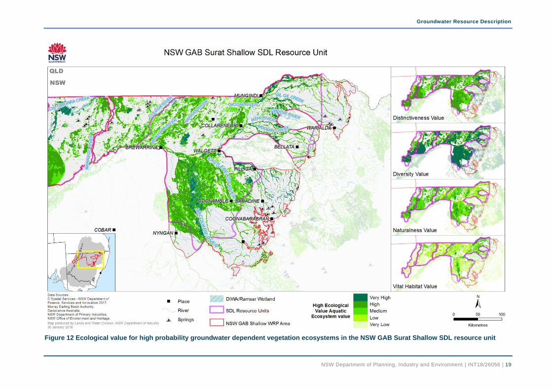
Figure 12 Ecological value for high probability groundwater dependent vegetation ecosystems in the NSW GAB Surat Shallow SDL resource unit ............................................................................ 19
Figure 13 Ecological value for high probability groundwater dependent vegetation ecosystems in NSW GAB Warrego and Central SDL resource units ..................................................................... 20
Figure 14 High priority groundwater dependent ecosystems (springs) in the NSW Great Artesian Basin Shallow WRP area (NSW Government, 2011) ......................................................................... 21
Figure 15 Annual water allocation for the NSW GAB Surat Shallow SDL resource unit................. 24
Figure 16 Water accounts for access licences in the NSW GAB Surat Shallow SDL resource unit ........................................................................................................................................................ 25
Figure 17 Annual extraction for the NSW GAB Surat Shallow SDL resource unit .......................... 26
Figure 18 Registered bores in the NSW Great Artesian Basin Shallow SDL resource units .......... 27
Figure 19 Schematic diagram of different types of aquifers ............................................................ 29
Figure 20 Location of monitoring bores in the NSW Great Artesian Basin Shallow SDL resource units ................................................................................................................................................ 30
Figure 21 Example of a groundwater hydrograph identifying trends in groundwater responses to pumping and climate ....................................................................................................................... 31
Figure 22 Hydrograph for monitoring bore site GW036698 ............................................................ 32
Figure 23 Hydrograph for monitoring bore site GW036198 ............................................................ 33
Figure 24 Hydrograph for monitoring bore site GW036882 ............................................................ 33
Figure 25 Hydrograph for monitoring bore site GW036883 ............................................................ 33
Figure 26 Hydrograph for monitoring bore site GW036884 ............................................................ 34
Figure 27 Hydrograph for monitoring bore site GW096105 ............................................................ 34

Groundwater Resource Description
NSW Department of Planning, Industry and Environment | INT18/26056 | iii
Tables Table 1 Access licence share components in the WRP area (as at October 2017) ....................... 23
Table 2 LTAAEL, SDL and the BLR water requirements for the NSW GAB Shallow SDL resource units (as at October 2017) .............................................................................................................. 23
Table 3 Water supply bore statistics in the NSW GAB Shallow SDL resource units (as at October 2017) ............................................................................................................................................... 26
Groundwater Resource Description
NSW Department of Planning, Industry and Environment | INT18/26056 | iv
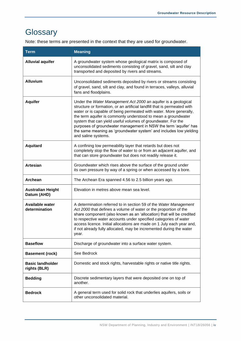
Glossary Note: these terms are presented in the context that they are used for groundwater.
Term Meaning
Alluvial aquifer A groundwater system whose geological matrix is composed of
unconsolidated sediments consisting of gravel, sand, silt and clay
transported and deposited by rivers and streams.
Alluvium Unconsolidated sediments deposited by rivers or streams consisting
of gravel, sand, silt and clay, and found in terraces, valleys, alluvial
fans and floodplains.
Aquifer Under the Water Management Act 2000 an aquifer is a geological
structure or formation, or an artificial landfill that is permeated with
water or is capable of being permeated with water. More generally,
the term aquifer is commonly understood to mean a groundwater
system that can yield useful volumes of groundwater. For the
purposes of groundwater management in NSW the term ‘aquifer’ has
the same meaning as ‘groundwater system’ and includes low yielding
and saline systems.
Aquitard A confining low permeability layer that retards but does not
completely stop the flow of water to or from an adjacent aquifer, and
that can store groundwater but does not readily release it.
Artesian Groundwater which rises above the surface of the ground under its own pressure by way of a spring or when accessed by a bore.
Archean The Archean Era spanned 4.56 to 2.5 billion years ago.
Australian Height
Datum (AHD)
Elevation in metres above mean sea level.
Available water
determination
A determination referred to in section 59 of the Water Management
Act 2000 that defines a volume of water or the proportion of the
share component (also known as an ‘allocation) that will be credited
to respective water accounts under specified categories of water
access licence. Initial allocations are made on 1 July each year and,
if not already fully allocated, may be incremented during the water
year.
Baseflow Discharge of groundwater into a surface water system.
Basement (rock) See Bedrock
Basic landholder
rights (BLR)
Domestic and stock rights, harvestable rights or native title rights.
Bedding Discrete sedimentary layers that were deposited one on top of another.
Bedrock A general term used for solid rock that underlies aquifers, soils or other unconsolidated material.

Groundwater Resource Description
NSW Department of Planning, Industry and Environment | INT18/26056 | v
Term Meaning
Beneficial use
(category)
1A general categorisation of groundwater uses based on water
quality and the presence or absence of contaminants. Beneficial use
is the equivalent to the ‘environmental value’ of water.
Bore (or well) A hole or shaft drilled or dug into the ground...
Brackish water Water with salinity between 3,000 and 7,000 mg/L total dissolved
solids.
Cenozoic The Cenozoic Era spanned from 66 million years ago to present
Confined aquifer An aquifer which is bounded above and below by impermeable
layers causing it to be under pressure so that when the aquifer is
penetrated by a bore, the groundwater will rise above the top of the
aquifer.
Connected water
sources Water sources that have some level of hydraulic connection.
Development (of a
groundwater resource) The commencement of extraction of significant volumes of water
from a water source.
Discharge Flow of groundwater from a groundwater source.
Drawdown The difference between groundwater level/pressure before take and
that during take.
Dual porosity Where a groundwater system has two types of porosity; primary
porosity resulting from the voids between the constituent particles
forming the rock mass, and secondary porosity resulting from
dissolution, faulting and jointing of the rock mass.
Electrical conductivity
(EC) Ability of a substance to conduct an electrical current. Used as a
measure of the concentration of dissolved ions (salts) in water (i.e.
water salinity). Measured in micro-Siemens per centimetre (µS/cm)
or deci-Siemens per metre (dS/m) at 25o C. 1 dS/m = 1000 µS/cm
Environmental Value 2Particular values or uses of the environment that are important for a
healthy ecosystem or for public benefit, welfare, safety or health and
which require protection from the effects of contamination, waste
discharges and deposits.
Fractured rock Rocks with fractures, joints, bedding planes and cavities in the rock
mass.
Geological sequence A sequence of rocks or sediments occurring in chronological order.
1 As defined in ‘Macro water sharing plans – the approach for groundwater’ (DPI Water, 2015)
2 As defined in ‘Guidelines for Groundwater Quality Protection in Australia 2013’ (ANZECC & ARMCANZ, 2013)
Groundwater Resource Description
NSW Department of Planning, Industry and Environment | INT18/26056 | vi
Term Meaning
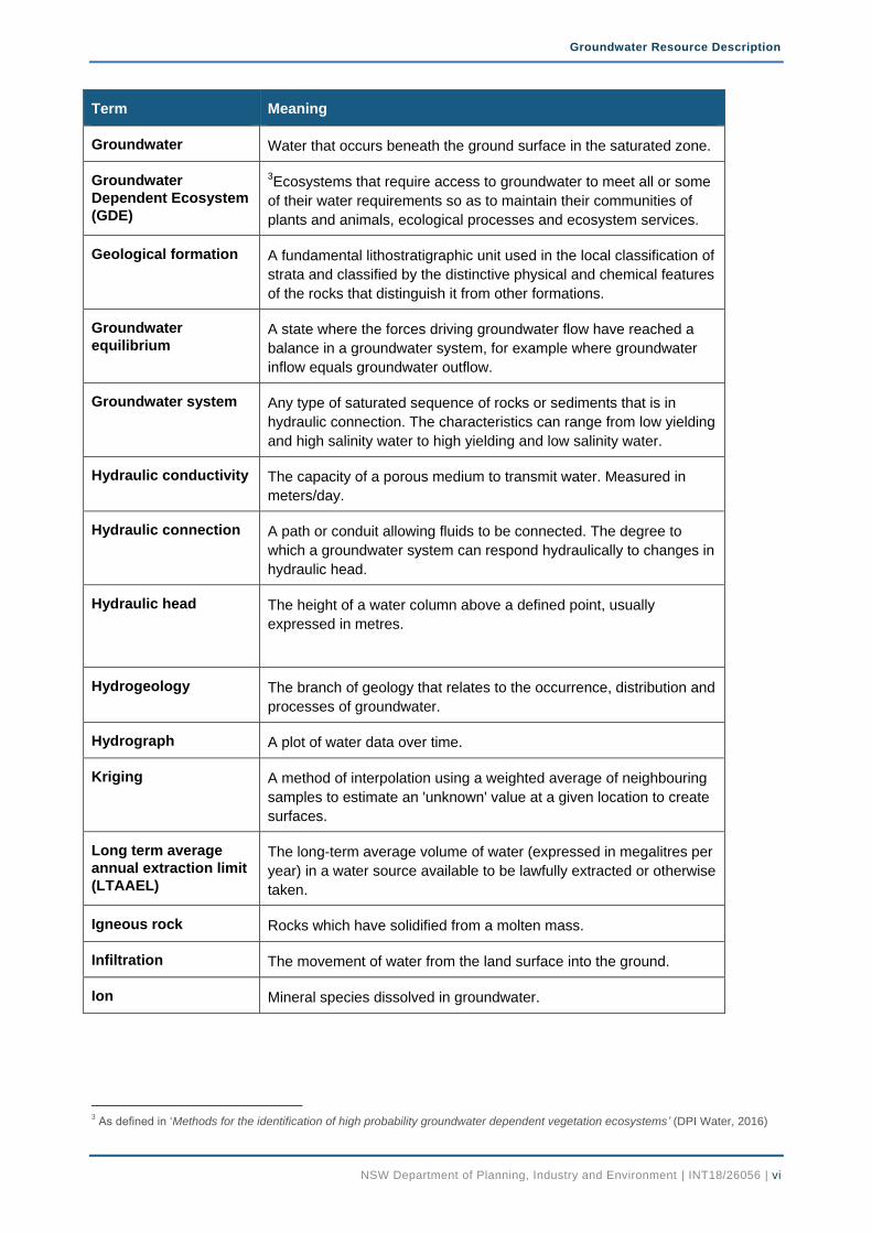
Groundwater Water that occurs beneath the ground surface in the saturated zone.
Groundwater
Dependent Ecosystem
(GDE)
3Ecosystems that require access to groundwater to meet all or some
of their water requirements so as to maintain their communities of
plants and animals, ecological processes and ecosystem services.
Geological formation A fundamental lithostratigraphic unit used in the local classification of
strata and classified by the distinctive physical and chemical features
of the rocks that distinguish it from other formations.
Groundwater
equilibrium A state where the forces driving groundwater flow have reached a
balance in a groundwater system, for example where groundwater
inflow equals groundwater outflow.
Groundwater system Any type of saturated sequence of rocks or sediments that is in
hydraulic connection. The characteristics can range from low yielding
and high salinity water to high yielding and low salinity water.
Hydraulic conductivity The capacity of a porous medium to transmit water. Measured in
meters/day.
Hydraulic connection A path or conduit allowing fluids to be connected. The degree to
which a groundwater system can respond hydraulically to changes in
hydraulic head.
Hydraulic head The height of a water column above a defined point, usually
expressed in metres.
Hydrogeology The branch of geology that relates to the occurrence, distribution and
processes of groundwater.
Hydrograph A plot of water data over time.
Kriging A method of interpolation using a weighted average of neighbouring
samples to estimate an 'unknown' value at a given location to create
surfaces.
Long term average
annual extraction limit
(LTAAEL)
The long-term average volume of water (expressed in megalitres per
year) in a water source available to be lawfully extracted or otherwise
taken.
Igneous rock Rocks which have solidified from a molten mass.
Infiltration The movement of water from the land surface into the ground.
Ion Mineral species dissolved in groundwater.
3 As defined in ‘Methods for the identification of high probability groundwater dependent vegetation ecosystems’ (DPI Water, 2016)

Groundwater Resource Description
NSW Department of Planning, Industry and Environment | INT18/26056 | vii
Term Meaning
Make good provisions
(in reference to a
water supply work)
The requirement to ensure third parties have access to an equivalent
supply of water through enhanced infrastructure or other means for
example deepening an existing bore, funding extra pumping costs or
constructing a new pipeline or bore.
Management zone A defined area within a water source where a particular set of water
sharing rules applies.
Mesozoic The Mesozoic Era spanned 252 to 66 million years ago
Metamorphic rock Rocks that result from partial or complete recrystallisation in the solid
state of pre-existing rocks under conditions of temperature and
pressure.
Minimal impact
considerations Factors that need to be assessed to determine the potential effect of
aquifer interference activities on groundwater and its dependent
assets.
Monitoring bore A specially constructed bore used to measure groundwater level or
pressure and groundwater quality at a specific depth. Not intended to
supply water.
Ongoing take The take of groundwater that occurs after part or all of the principal
activity has ceased. For example, extraction of groundwater (active
take) entering completed structures, groundwater filling abandoned
underground workings (passive take) or the evaporation of water
(passive take) from an abandoned excavation that has filled with
groundwater.
Outcrop Rocks which are exposed at the land surface.
Piezometric or
Potentiometric head The pressure or hydraulic head of the groundwater at a particular
depth in the ground. In unconfined aquifers, this is the same as the
water table.
Palaeozoic The Palaeozoic Era spanned 541 to 252 million years ago.
Perched water table A local water table of very limited extent which is separated from the
underlying groundwater by an unsaturated zone.
Permeability The capacity of earth materials to transmit a fluid.
Porous rock Consolidated sedimentary rock containing voids, pores or other
openings in the rock (such as joints, cleats and/or fractures.
Pre-development Prior to development of a groundwater resource.
Proterozoic The Proterozoic Era spanned 2.5 billion to 541 million years ago.
Recharge The addition of water into a groundwater system by infiltration, flow
or injection from sources such as rainfall, overland flow, adjacent
groundwater sources, irrigation, or surface water sources.

Groundwater Resource Description
NSW Department of Planning, Industry and Environment | INT18/26056 | viii
Term Meaning
Recovery The rise of groundwater levels or pressures after groundwater take
has ceased. Where water is being added, recovery will be a fall.
Recovery decline Where groundwater levels or pressures do not fully return to the
previous level after a period of groundwater removal or addition.
Reliable water supply 4Rainfall of 350mm or more per annum (9 out of 10 years); or a
regulated river, or unregulated rivers where there are flows for at
least 95% of the time (i.e. the 95th percentile flow of each month of
the year is greater than zero) or 5th order and higher rivers; or
groundwater aquifers (excluding miscellaneous alluvial aquifers, also
known as small storage aquifers) which have a yield rate greater
than 5L/s and total dissolved solids of less than 1,500mg/L.
River Condition Index
(RCI) This is a spatial tool used to measure and monitor the long-term
trend of river condition, but also reports on instream values and risk
to instream values from extraction and geomorphic disturbance.
Salinity The concentration of dissolved minerals in water, usually expressed
in EC units or milligrams of total dissolved solids per litre.
Salt A mineral which in a liquid will readily dissociate into its component
ionic species for example NaCl into Na+ and Cl
- ions.
Saturated zone Area below the water table where all soil spaces, pores, fractures
and voids are filled with water.
Sedimentary rock A rock formed by consolidation of sediments deposited in layers, for
example sandstone, siltstone and limestone.
Share component An entitlement to water specified on an access licence, expressed as
a unit share or for specific purpose licences a volume in megalitres
(eg. local water utility, major water utility and domestic and stock).
Sustainable Diversion
Limits The volume of water that can be taken from a Sustainable Diversion
Limit resource unit as defined under the Murray Darling Basin Plan
2012.
Unassigned water Exists where current water requirements (including licensed volumes
and water to meet basic landholder rights) are less than the
extraction limit for a water source.
Unconfined aquifer A groundwater system usually near the ground surface, which is in
connection with atmospheric pressure and whose upper level is
represented by the water table.
Unconsolidated
sediment Particles of gravel, sand, silt or clay that are not bound or hardened
by mineral cement, pressure, or thermal alteration of the grains.
4 As defined in ‘Strategic Regional Land Use Plans’ ( (Department of Planning and Infrastructure, 2012)

Groundwater Resource Description
NSW Department of Planning, Industry and Environment | INT18/26056 | ix
Term Meaning
Unsaturated zone Area above the water table where soil spaces, pores, fractures and
voids are not completely filled with water.
Water balance A calculation of all water entering and leaving a system.
Water resource plan 5A plan made under the Commonwealth Water Act 2007 that outlines
how a particular area of the Murray–Darling Basin’s water resources
will be managed to be consistent with the Murray–Darling Basin
Plan. These plans set out the water sharing rules and arrangements
relating to issues such as annual limits on water take, environmental
water, managing water during extreme events and strategies to
achieve water quality standards and manage risks.
Water sharing plan 6A plan made under the Water Management Act 2000 which set out
the rules for sharing water between the environment and water users
within whole or part of a water management area or water source.
Water source Defined under the Water Management Act 2000 as ‘The whole or
any part of one or more rivers, lakes or estuaries, or one or more
places where water occurs naturally on or below the surface of the
ground and includes the coastal waters of the State. Individual water
sources are more specifically defined in water sharing plans.
Water table Upper surface of groundwater at atmospheric pressure, below which
the ground is saturated.
Water year Twelve month period from 1 July to 30 June.
Yield The amount of water that can be supplied over a specific period.
5 https://www.mdba.gov.au/basin-plan-roll-out/water-resource-plans 21/03/17
6 As defined in ‘Macro water sharing plans – the approach for groundwater’ (DPI Water, 2015)

Groundwater Resource Description
NSW Department of Planning, Industry and Environment | INT18/26056 | 1
1. Introduction The NSW Government is developing water resource plans as part of implementing the Murray-Darling Basin Plan 2012 (the Basin Plan). Water resource plans align Basin-wide and state-based water resource management in each water resource plan area. The water resource plans recognise and build on the existing water planning and management frameworks that have been established in NSW.
Under the Basin Plan, individual water resources are known as sustainable diversion limit (SDL) resource units and each water resource plan covers a number of SDL resource units within an area.
The Great Artesian Basin Water Resource Plan (WRP) area is shown in Figure 1 and is located within the Barwon-Darling River catchment that forms part of the Murray-Darling Basin in northern NSW. The WRP area covers about 138,400 km² and represents approximately 13 percent of the Murray-Darling Basin. The WRP area extends from east of North Star to west of Paroo River.
Although the WRP area extends across the recharge areas of the Great Artesian Basin, there is no SDL resource unit within this area of the WRP. The Commonwealth Water Act 2007 excludes all water that forms part of the Great Artesian Basin from the Murray-Darling Basin water resources. That is, the artesian sandstone aquifers and their recharge areas are not managed under the Murray-Darling Basin Plan. Therefore, whilst the boundary of the WRP area is based on the NSW Great Artesian Basin (GAB) that falls within the Murray-Darling surface water catchment, it does not include the groundwater resources managed under the Water Sharing Plan for the NSW Great Artesian Basin Groundwater Sources 2008. The relationship between the NSW water sharing plans and this WRP is shown schematically in Figure 2.
This WRP covers the uppermost groundwater systems that overly or are partly within the confining beds of the Great Artesian Basin. It includes all groundwater contained within the unconsolidated sediments regardless of depth and all other geological formations to a maximum depth of 60 m below the surface of the ground. A number of unconsolidated alluvium WRP areas corresponding to valley systems lie above the Great Artesian Basin.
The WRP (GW13 – Murray-Darling Basin reference number) includes three SDL resource units (Figure 1 inset): the NSW GAB Surat Shallow (GS34), the NSW GAB Warrego Shallow (GS35) and the NSW GAB Central Shallow (GS36).
Groundwater resources managed by the Water Sharing Plan for the NSW Great Artesian Basin Shallow Groundwater Sources 2011 that fall within the Murray-Darling Basin surface water catchment directly correlate to these three SDL resource units.
This report describes the location, climate and physical attributes of the WRP area, and explains the SDL units’ geological and hydrogeological context, environmental assets, groundwater quality and management. It also presents the status of these SDL resource units including groundwater rights, accounts, dealings, take and groundwater behaviour.
2. History of Groundwater Management
2.1. Early groundwater management The Water Act 1912 (WA 1912) was introduced at a time when the development of water resources for agriculture and regional development were the priority of government (DLWC, 1999). Under the WA 1912, water entitlement was linked to land rights and licences for bores and wells were granted for a fixed term with no restriction on the volume that could be extracted. Bore licences were initially required only for bores greater than 30 metres (m) depth in the western half of NSW.

Groundwater Resource Description
NSW Department of Planning, Industry and Environment | INT18/26056 | 2
Figure 1 Location of the NSW Great Artesian Shallow WRP area and SDL resource units

Groundwater Resource Description
NSW Department of Planning, Industry and Environment | INT18/26056 | 3
Figure 2 Schematic cross section of the SDL resource units in the NSW Great Artesian Basin Shallow WRP area and their relationship to the NSW water sharing plans and their groundwater sources

Groundwater Resource Description
NSW Department of Planning, Industry and Environment | INT18/26056 | 4
After World War II, there was a drive to expand irrigation and promote economic development in inland NSW. In 1955, the WA 1912 was amended to require all bores to be licensed irrespective of depth or location.
By the 1970s, the rapid expansion of the irrigation industry, increasing competition for water resources and extended periods of drought were affecting the reliability of water supplies in inland NSW.
Acknowledging that groundwater was a finite resource, from 1972 to 1983 new irrigation licences were issued based on the size of the area being irrigated. These licences had to be renewed every five years, but still had no volumetric limit on extraction (Gates & O'Keefe, 1997 Unpublished).
From 1984, all new high yield bores and wells (greater than 20 megalitres) except those in the Great Artesian Basin, were given a volumetric entitlement and old area based licences were progressively converted. Volumetric entitlements were generally issued, based on historical usage, property area or bore capacity.
From 1986, comprehensive volumetric groundwater allocation policies were introduced throughout the State.
The objectives were to more effectively manage development in those groundwater systems where the resource was fully committed and to encourage the use of groundwater where it was underutilised.
2.2. NSW water reforms In 1994, the Council of Australian Governments endorsed a strategic framework for reform of the Australian water industry. The framework included identifying and recovering the costs of water management and supply from beneficiaries, recognising the environment as a water user through formal allocations and ensuring that water rights could move by trade to where they would generate the highest value.
By the late 1990s, NSW had embarked on a major program of water policy reforms. This included the development of the NSW State Groundwater Policy Framework Document, the NSW Groundwater Quality Protection Policy, and an assessment of risk to the State’s groundwater systems from over-extraction and/or contamination. The NSW State Groundwater Dependent Ecosystems Policy was released in 2002.
The 1990s policy reforms drove the development of the Water Management Act 2000 (WMA 2000). The WMA 2000 establishes water for the environment as a priority while also providing licence holders with more security through perpetual licences and greater opportunities to trade through the separation of water access rights from the land.
The WMA 2000 considers other users of water such as groundwater dependent ecosystems, and aquifer interference activities; cumulative impacts; climate change; Aboriginal cultural rights and connectivity between groundwater and surface water. The WMA 2000 also sets up the framework for developing statutory plans to manage water.
Water sharing plans are the principal tool for managing the State’s water resources including groundwater. These ten-year plans manage groundwater resources at the ‘water source’ scale, define the long-term average annual extraction limit (LTAAEL), establish rules for sharing groundwater between users and the environment, establish basic landholder rights and set rules for water trading.
Priority for developing water sharing plans was based on the groundwater systems identified by the risk assessment as being at highest risk. The first groundwater sharing plans in the Murray-Darling Basin commenced between 2006 and 2008 across six large alluvial groundwater systems in the Murray-Darling Basin. Access to groundwater was reduced to the extraction limit over the ten-year plan using an approach that recognised historical extraction.

Groundwater Resource Description
NSW Department of Planning, Industry and Environment | INT18/26056 | 5
Since 2007, water sharing plans for unregulated rivers and groundwater systems in NSW have been completed using a 'macro' approach to cover most of the remaining water sources across NSW. Each groundwater macro plan covers a number of a particular type of groundwater system (for example, fractured rock).
In 2008, two embargo orders covering the remaining inland groundwater resources were made under the WA 1912 on new applications for groundwater licences. These embargoes remained in effect until the commencement of water sharing plans for the groundwater sources that they covered.
In 2012, the ‘NSW Aquifer Interference Policy’ was released. The purpose of this Policy is to explain the water licensing and assessment requirements for aquifer interference activities under the WMA 2000 and other relevant legislative frameworks.
2.3. History of groundwater management in the NSW GAB Shallow Groundwater Sources
There has been little groundwater based development in the NSW GAB Shallow Groundwater Sources. These groundwater sources were part of groundwater management areas previously referred as Central West Alluvium and Great Artesian Basin Alluvium. The entitlements were issued for new bores based on property area and capped to a maximum entitlement of 486 ML/year.
An embargo on further licence applications for irrigation and industrial purposes in these groundwater sources was placed on 18 December 2008. This embargo remained in place until the commencement of the Water Sharing Plan for the NSW Great Artesian Basin Shallow Groundwater Sources 2011 on 14 November 2011.
3. Regional Setting
3.1. Topography and hydrology The Barwon–Darling, Culgoa, Namoi, Gwydir, Macquarie, Bogan, Castlereagh, Warrego and Paroo River systems and their flood plains, and the peak of Warrumbungle Ranges are the dominant topographical features within the WRP area. The elevation across the WRP area decreases from east to west. The elevation ranges from over 1,200 m Australian Height Datum (AHD) in the Warrumbungle Range to 80 m AHD east of White Cliffs in the south west of the WRP area (Figure 3). The WRP area is dominated by wide flood plains with elevation less than 200 m AHD and tributaries into Barwon-Darling River.
The Barwon River starts at an elevation of 200 m AHD at the confluence of the Macintyre and Weir Rivers, and flows for approximately 700 km over a low gradient to an elevation of 110 m at its confluence with Culgoa River (MDBA, 2017). Downstream of the Culgoa confluence, the Barwon River becomes the Darling River, and flows another 900 km to the Menindee Lakes.
The Namoi River above Keepit Dam starts at elevations over 1,000 m AHD in the Great Dividing Range to the south east of Tamworth. The Namoi River flow is regulated downstream of Keepit Dam. The Namoi River joins with the Barwon River at Walgett.
The Gwydir River begins at an elevation of 1,200 m AHD near Uralla and the flow is regulated downstream of the Copeton Dam. Downstream of Moree, the Gwydir River splits into two major streams: the Gingham Watercourse and the Lower Gwydir Watercourse, which is also known as the Big Leather Watercourse. Both water courses confluence with the Barwon River upstream of Collarenebri.

Groundwater Resource Description
NSW Department of Planning, Industry and Environment | INT18/26056 | 6
Figure 3 Topography and elevation map of the NSW Great Artesian Basin Shallow WRP area (Gallant, et al., 2009)

Groundwater Resource Description
NSW Department of Planning, Industry and Environment | INT18/26056 | 7
The Macquarie River originates south of Bathurst in the Great Dividing Range and flows in the north westerly direction into Macquarie Marshes, and joins the Barwon River downstream of Walgett. The Macquarie River flow is regulated downstream of the Burrendong Dam.
From its headwaters near Harvey Ranges, south west of Dubbo, the Bogan River flows parallel to Macquarie River before joining with Barwon River between Bourke and Brewarrina.
The Castlereagh River starts in the Warrumbungle Ranges near Coonabarabaran, and flows south west, then north west for 549 km to its confluence with the Macquarie River. It runs parallel to Barwon River at the lower end of the river reach. Here the lower flood plain carries flows from the Barwon River through to the Castlereagh River during major floods.
The Warrego River starts at an elevation about 600 mAHD near Carnarvon Range in Queensland and flows southwards to the flood plains of north western New South Wales where it meets Darling River downstream of Bourke near Louth. The Warrego flows intermittently and generally ends in large swamps and storages near Louth. In wet years, waters of the Warrego River system flow through Cuttaburra Creek to the lower reaches of the Paroo River (MDBA, 2017).
The Paroo River is an ephemeral river, flowing mainly when heavy rains fall in its northern catchment. Mostly, the river is a series of waterholes, lakes and wetlands. In wet years, the Paroo's floodwaters typically end at the Paroo overflow lakes on the floodplains south of Wanaaring. Only in exceptionally wet years will the Paroo join the Darling River, which occurred only four times between 1900 and 2010 (MDBA, 2017).
3.2. Climate The climate in the central and western part of the WRP area is influenced by its low-lying topography and distance from the coast. Figure 4 shows that the eastern fringe experiences the highest rainfall totals in the area, whilst the central and western parts are very dry. Average annual rainfall gradually decreases westward from approximately 750 mm at Coonabarabran in the south east and 620 mm at Pallamallawa in the east to 280 mm in the west at Wanaaring. Although rainfall can vary considerably between years, rainfall across the WRP area tends to be summer dominant whilst almost double the rainfall occurs in each month in the east compared to the west (Figure 5).
The WRP area experiences arid to semi-arid climate characterised by warm to hot summers and mild winters. At the higher elevations in the south east near Coonabarabran, temperatures vary from a winter average minimum of 0° Celsius (C) to a summer average maximum to 32°C. In the far west near Wanaaring, the temperatures range from winter average minimum of around 4°C to a summer average maximum of 37°C.
Climate change modelling (OEH, 2014) projects the maximum temperatures to increase in the near future (2020–2039) by 0.3-1.0°C and 1.8-2.7°C in the far future (2060-2079). The rainfall is projected to decrease in spring and increase in summer and autumn.

Groundwater Resource Description
NSW Department of Planning, Industry and Environment | INT18/26056 | 8
Figure 4 Average annual rainfall map of the NSW Great Artesian Basin Shallow WRP area (Bureau of Meteorology, 2008)7
7 The average rainfall period 1976 - 2005 displayed in this map is the current standardised average conditions gridded data set available from the Bureau of Meteorology.

Groundwater Resource Description
NSW Department of Planning, Industry and Environment | INT18/26056 | 9
Figure 5 Average monthly rainfall for Wanaaring Post Office and Pallamallawa Post Office
Figure 6 shows that evaporation in the WRP area has a strong gradient increasing from east to west. Yearly evaporation varies from around 1,600 mm in the east to over 2,400 mm in the west. Annual evaporation significantly exceeds the annual rainfall across the WRP area.
Evaporation is strongly seasonal throughout the year. The average daily evaporation rates at Moree Airport vary from 10 mm/day in summer months to about 3 mm/day in winter months (Figure 7).
Residual rainfall graph has been constructed from daily rainfall data sourced from the Bureau of Meteorology (Bureau of Meteorology, 2017). The residual rainfall mass graph plots the cumulative difference from the monthly average rainfall and provides a visual representation of the rainfall history in an area. A falling trend indicates a period of lower than average rainfall, a rising trend showing periods of above average rainfall.
Figure 8 shows the residual rainfall mass graph of average monthly rainfall from 1966 to 2016 at Wanaaring Post Office and Pallamallawa Post Office. It shows a below average rainfall trend during the millennium drought from 2001 to 2009, followed by an above average spike over the 2010 to 2012 period then below average trend to 2016.

Groundwater Resource Description
NSW Department of Planning, Industry and Environment | INT18/26056 | 10
Figure 6 Average annual evaporation map of the NSW Great Artesian Basin Shallow WRP area (Bureau of Meteorology, 2008)8
8 The average evaporation period 1976 - 2005 displayed in this map is the standardised average conditions gridded data set available from the Bureau of Meteorology.

Groundwater Resource Description
NSW Department of Planning, Industry and Environment | INT18/26056 | 11
Figure 7 Average daily evaporation rate for Moree Airport
Figure 8 Wanaaring and Pallamallawa residual rainfall mass graph 1966 - 2016

Groundwater Resource Description
NSW Department of Planning, Industry and Environment | INT18/26056 | 12
3.3. Land use The predominant land use in the WRP area is low intensity grazing on pastoral leases. Additional activities which occur in the WRP area include dryland farming, irrigated agriculture, forestry and mining. Figure 9 shows land use information across the WRP area based on the Australian Bureau of Agricultural and Resource Economics and Sciences 2010/2011 land use data (Smart, 2016).
The Barkindji, Bigambul, Budjiti, Euahlayi, Kambuwal, Guwamu/Kooma, Kamilaroi/Gomeroi, Kunja, Kwiambul, Maljangapa, Murrawarri, Ngarabal, Ngemba, Wailwan and Wiradjuri people were the original inhabitants in the WRP area. The springs and associated wetlands of the WRP area were a source of sustenance for the Aboriginal nations of these lands, often serving as clan meeting places, and have an important place in the Dreaming. Whilst the groundwater that feed these springs flows through the GAB Shallow groundwater sources, it originates from the deeper GAB aquifers that underlie the groundwater resources of this WRP (NOW, 2011).
In the late 1860s with the arrival of the pioneering pastoralists, Aboriginal people were displaced as the landscapes were transformed for grazing and agricultural purposes. The early European settlers were seeking landscapes for grazing sheep and cattle and for other forms of agriculture. Large stations became established in the area, and the introduction of riverboats increased the number of people moving to the area.
Today the area is made up of large pastoral stations, which occupy all the leasehold land within the plan area aside from, the scattering of localities, and national parks or nature reserves. There are areas within the plan area that remain under native vegetation and some of these are protected as national park or nature reserves. The Paroo River is protected through an inter-governmental agreement between NSW and Queensland. Similarly, the terminal Narran Lake, at the end of the Narran River system is a RAMSAR protected wetland.
The Ramsar listed Macquarie wetlands and a part of Gwydir wetlands also fall in the WRP area and are protected in the Macquarie Marshes Nature Reserve and State Conservation Area and the Gwydir State Conservation Area respectively.
Pilliga Forest, the largest native forest in inland NSW, is located between Coonabarabran and Narrabri. The Pilliga West State Conservation Area and Pilliga and Pilliga West National Parks are within the WRP area.
Agriculture is the largest user of NSW GAB Shallow groundwater resources. Much of the land use overlying these water sources, however, relies on water from other water sources in the same geographic area, particularly the reliable good quality water of the deep GAB groundwater sources.

Groundwater Resource Description
NSW Department of Planning, Industry and Environment | INT18/26056 | 13
Figure 9 Land use map of the NSW Great Artesian Basin Shallow WRP area (Smart, 2016)
Groundwater Resource Description
NSW Department of Planning, Industry and Environment | INT18/26056 | 14
4. Geology The surface geology of the NSW GAB Shallow WRP area is made up of three main geological sequences including; the Mesozoic Great Artesian Basin (GAB), the Cenozoic unconsolidated sediments, and the Cenozoic extrusive volcanics (Figure 10).
The main peak near Coonabarabran and topographic high near Warialda in the WRP area are formed by Cenozoic extrusive volcanic rocks of basalts that were erupted during widespread volcanic activity throughout the eastern part of the state over the last sixty-five million years.
The Cenozoic unconsolidated sediments that overlie Mesozoic rocks cover most of the WRP area. These are mainly flood plain and marshy environment deposits with occasional interlayers of low to medium energy fluvial deposits (Watkins & Meakin, 1996). They were deposited on the eroded and weathered surface of the Rolling Downs Group (Ransley & Smerdon, 2012).
The Mesozoic sedimentary rocks that form Great Artesian Basin sit atop older geological basins, the Gunnedah Basin and other basement fold belts. The Mesozoic sediments consist of sandstone, mudstone, siltstone, shale and coal.
The late Palaeozoic Gunnedah Basin is a sedimentary coal basin that occurs only at depth, and does not outcrop at the surface of the WRP area.
The basement fold belts are completely buried in the WRP area. The Paleoproterozoic Adelaide Fold Belt is the oldest among the buried fold belts and it comprises strongly deformed and metamorphosed sedimentary and igneous rocks. The Early Palaeozoic Kanmantoo Fold Belt consists of deformed metasediments. The Palaeozoic Lachlan Fold Belt comprises sedimentary rocks, metasediments and metavolcanics.
5. Hydrogeology
5.1. Regional context The WRP covers all groundwater that is contained within the unconsolidated sediments regardless of depth and all other geological formations to a maximum depth of 60 m below the surface of the ground.
The NSW GAB Shallow SDL resource units include the Cenozoic unconsolidated sediments and other geological formations of Early Cretaceous age (approximately 100 million years old) referred to as the Rolling Downs Group. Figure 2 shows the schematic section of these SDL units over the WRP area.
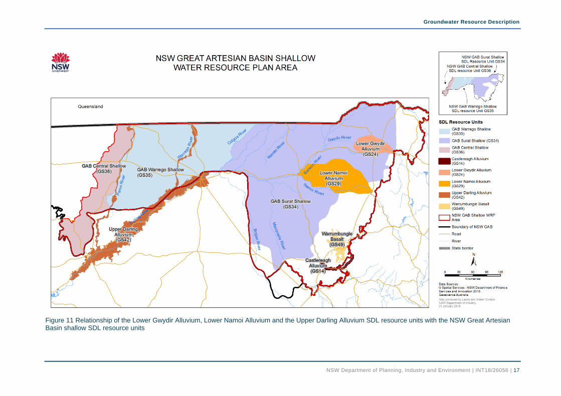
The unconsolidated sediments are made up of clay, silt, sand, and gravels primarily deposited by the river systems of the Darling River drainage basin but they also include wash from hill slopes. These extensive floodplain deposits are a continuum of the alluvium incorporated into the SDL resource units of the Lower Namoi Alluvium, the Lower Gwydir Alluvium and the Upper Darling Alluvium. Whilst these three alluvium SDL resource units are within the geographic area of this WRP, they are not part of this WRP as they are covered by the Namoi Alluvium, Gwydir Alluvium and Darling Alluvium water resource plans respectively. The geographic relationship of these SDL resource units is shown in Figure 11.
The Rolling Downs group represents consolidated sediments deposited in the early Cretaceous marine transgression and regression and forms upper units of the Great Artesian Basin. They consist of claystone, mudstone, calcrete and shale with minor interlayers of conglomerate and sandstone.
The NSW GAB Shallow SDL resource units sit over and adjacent to the NSW GAB Groundwater Sources, Lachlan Fold Belt SDL resource unit and Kanmantoo Fold Belt SDL resource unit. The permeability of the underlying and adjacent rocks of the Lachlan Fold Belt and Kanmantoo Fold Belt SDL resource units, and the NSW GAB Groundwater Sources is many orders of magnitude

Groundwater Resource Description
NSW Department of Planning, Industry and Environment | INT18/26056 | 15
lower than that of the NSW GAB Shallow SDL resource units. Groundwater exchange between the NSW GAB Shallow SDL resource units and these low permeable underlying and adjacent rocks is insignificant in the context of the groundwater resources of the NSW GAB Shallow SDL resource units. Consequently the Lachlan Fold Belt and Kanmantoo Fold Belt SDL resource units and the NSW GAB Groundwater Sources are not considered hydraulically connected in a resource management sense to the resources in the NSW GAB Shallow SDL resource units.
The major source of recharge to the NSW GAB Shallow SDL resource units is diffuse rainfall recharge. Some minor recharge is also expected to occur as downward leakage from rivers. The discharge from the SDL resource units is primarily extraction for stock use. In the Surat Shallow SDL resource unit, there is also extraction for minor irrigation and domestic use.
Lack of spatially extensive groundwater level information and lateral discontinuity of aquifers in the SDL units hinder the determination of groundwater flow direction in these SDL units. However, at a regional scale it is expected to reflect the subdued topography of the landscape and the surface water drainage basins.
5.2. NSW GAB Surat Shallow SDL resource unit The Cenozoic unconsolidated sediment cover is extensive across the NSW GAB Surat Shallow SDL resource unit. The thickness of these unconsolidated sediments varies from about 10 m to 80 m and reaches its maximum near Walgett. This SDL resource unit falls predominantly within the unconsolidated sediments rather than the underlying Rolling Downs Group.
The aquifers in this SDL resource unit are unconfined to semi confined and are laterally disconnected across the resource unit. However, within the alluvium there is expected to be more continuity in the distribution of local aquifers connected with the major rivers. Though the aquifers in this SDL resource unit typically produce low yield of brackish water, local supplies of potable water from bores drilled near creeks or rivers can be obtained.
5.3. NSW GAB Warrego and Central Shallow SDL resource units
In the NSW GAB Warrego and Central Shallow SDL resource units, the Cenozoic unconsolidated sediment cover tends to be limited to a thin veneer in most places and the groundwater tends to occur predominantly in the underlying Rolling Downs Group. The aquifers in these two SDL units are unconfined to semi confined and laterally disconnected across the resource units.
5.4. Connection with surface water There is minimal data on the connection of surface water with the NSW GAB Shallow SDL resource units although the level of connection is expected to be low. River recharge would be minor due to low permeability of the river bed sediments of the slow flowing rivers within the SDL resource units. The river recharge to the SDL resource units is not influenced by groundwater pumping due to anticipated occurrence of water table much below the river bed level.

Groundwater Resource Description
NSW Department of Planning, Industry and Environment | INT18/26056 | 16
Figure 10 Geology of the NSW Great Artesian Basin Shallow WRP area
Groundwater Resource Description
NSW Department of Planning, Industry and Environment | INT18/26056 | 17
Figure 11 Relationship of the Lower Gwydir Alluvium, Lower Namoi Alluvium and the Upper Darling Alluvium SDL resource units with the NSW Great Artesian Basin shallow SDL resource units

Groundwater Resource Description
NSW Department of Planning, Industry and Environment | INT18/26056 | 18
6. Groundwater Dependent Ecosystems Groundwater dependent ecosystems are defined as ‘ecosystems that require access to groundwater to meet all or some of their water requirements so as to maintain their communities of plants and animals, ecological processes and ecosystem services’ (DPI Water, 2016).
Department of Planning, Industry and Environment—Water has developed a method for the identification of high probability groundwater dependent vegetation ecosystems (DPI Water, 2016) and associated ecological value (Dabovic, et al., In prep). This process has identified many high probability vegetation GDEs and their ecological values in the NSW GAB Shallow WRP area.
This mapping exercise shows the GAB Shallow groundwater sources support significant GDEs of ecological value including wetlands, springs, vegetation and baseflow ecosystems. The high probability GDE’s ecological value in the GAB Shallow WRP area (Figure 12 and Figure 13) is mainly classified as very high and high.
The WRP area is dominated by the vegetation GDE communities of River Red Gum woodland wetlands, Lignum wetlands, freshwater wetlands, Black Box woodlands, Coolabah-River Coolabah-Lignum woodland wetlands and chenopod shrublands, Bladder Salt Bush, Poplar Box woodlands, Gidgee chenopod woodlands, Leopard Wood woodlands, permanent and shallow wetlands. These communities are characterised by having endangered ecological communities, Directory of important wetlands in Australia (DIWA)/Ramsar wetlands (Paroo Wetlands, Narran Lake, Macquarie Marshes, Gwydir Wetlands), extensive connected riparian corridors and basin target vegetation species (MDBA, 2014) of Black Box, Lignum and River Red Gums. The riparian communities provide vital habitat to nesting species and contribute to ecosystem function of instream ecosystems.
Generally, the high probability GDE communities with high ecological value have large vegetation patches, are highly connected (such as riparian corridors) and have a moderate number of threatened species present especially in the wetland areas.
The Water Sharing Pan for NSW GAB Shallow Groundwater Sources 2011 identified many springs (Figure 14) as high priority groundwater dependent ecosystems over the WRP area. Although groundwater flows through the NSW GAB Shallow SDL resource units to discharge as springs at the land surface, the groundwater can originate in the underlying deeper NSW GAB groundwater sources.
Groundwater Resource Description
NSW Department of Planning, Industry and Environment | INT18/26056 | 19
Figure 12 Ecological value for high probability groundwater dependent vegetation ecosystems in the NSW GAB Surat Shallow SDL resource unit

Groundwater Resource Description
NSW Department of Planning, Industry and Environment | INT18/26056 | 20
Figure 13 Ecological value for high probability groundwater dependent vegetation ecosystems in NSW GAB Warrego and Central SDL resource units

Groundwater Resource Description
NSW Department of Planning, Industry and Environment | INT18/26056 | 21
Figure 14 High priority groundwater dependent ecosystems (springs) in the NSW Great Artesian Basin Shallow WRP area (NSW Government, 2011)

Groundwater Resource Description
NSW Department of Planning, Industry and Environment | INT18/26056 | 22
7. Groundwater Quality Water quality describes the condition of water within a water source and its related suitability for different purposes. The water quality characteristic of a groundwater system influence how that water is used by humans for town water or stock and domestic supply, or for commercial purposes such as farming and irrigation. If water quality is not maintained, it can impact on the environment as well as the commercial and recreational value of a groundwater resource.
One measure of quality most relevant to the end use is the level of salt present in groundwater, or groundwater salinity. This is determined by measuring the electrical conductivity (EC) and is generally reported in micro siemens per centimetre (μS/cm).
In NSW, groundwater salinity levels can range from that of rainwater (<250 μS/cm) to greater than that of sea water (~60,000 μS/cm). Groundwater with a salinity suitable for a range of productive uses, is generally found in the large unconsolidated alluvial systems associated with the major westward draining rivers.
Groundwater suitability can be changed by contaminants infiltrating into the groundwater system. This can be from spills or leaks onto the land surface but it can also occur more broadly from the overlying land use. Seasonal variations and longer-term changes in climate as well as groundwater extraction can all affect groundwater quality.
There is no quantitative water quality information available for these resource units but it can be inferred from the qualitative information provided in the drillers’ bore completion reports that the groundwater is brackish to saline in most areas with occasional low salinity water in isolated pockets near the Macquarie, Barwon, and Gwydir Rivers.
A combination of low hydraulic gradients associated with the low topographic relief of the landscape, low permeability of resource units, low rainfall and high evaporation rates results in the poor quality of the groundwater in these SDL resource units.
8. Groundwater Management The NSW GAB Shallow WRP (GW13 – Murray-Darling Basin reference number) includes three SDL resource units (Figure 1 inset): the NSW GAB Surat Shallow (GS34), the NSW GAB Warrego Shallow (GS35) and the NSW GAB Central Shallow (GS36). Groundwater resources managed by the Water Sharing Plan for the NSW Great Artesian Basin Shallow Groundwater Sources 2011 that fall within the Murray-Darling Basin surface water catchment directly correlate to these three SDL resource units.
The NSW GAB Shallow SDL resource units sit over and adjacent to the fractured rock management units of Lachlan Fold Belt and Kanmantoo Fold Belt, and the NSW GAB Groundwater Sources. These fractured rocks and the NSW GAB Groundwater Sources have very different hydrogeological characteristics and are not considered to be hydraulically connected in a resource management sense to the groundwater resources in the NSW GAB Shallow SDL resource units. Groundwater in the fractured rock management units is managed under the Water Sharing Plan for the NSW Murray Darling Basin Fractured Rock Groundwater Sources 2011 whilst groundwater in the NSW GAB Groundwater sources is managed under the Water Sharing Plan for the NSW Great Artesian Basin Groundwater Sources 2008.
8.1. Access rights There are three categories of water access licences held in these SDL resource units. These are aquifer access licences, local water utility access licences and domestic and stock access licences. Table 1 provides information on the details of groundwater access licences in each SDL resource units.

Groundwater Resource Description
NSW Department of Planning, Industry and Environment | INT18/26056 | 23
All take of water for industries such as irrigation, mining and tourism are required to hold aquifer access licences to account for their take of water. The share components of aquifer access licences are issued for a specified number of unit shares in each SDL resource unit.
The local water utility access licence is held by local government for town water supply purposes. The domestic and stock access licence is held by a community group and used for domestic and stock purposes. The share components of the local water utility, and domestic and stock access licences are for a specified volume of groundwater.
Table 1 Access licence share components in the WRP area (as at October 2017)
SDL Resource Unit Aquifer (unit shares) Local Water Utility
(ML/year) Domestic & Stock
(ML/year)
NSW GAB Surat Shallow 5,662 50 100
NSW GAB Warrego Shallow
0 0 0
NSW GAB Central Shallow 3 0 0
Total 5,665 50 100
8.2. Extraction limits Extraction in a groundwater source is managed to the long-term average annual extraction limit (LTAAEL) set by the water sharing plan.
Water resource plans will set limits, in the same way as water sharing plans, on the quantities of water that can be taken from the Basin water resources. These limits are known as sustainable diversion limits (SDLs). Under the water resource plans NSW will manage extraction to ensure compliance with the SDLs.
Table 2 lists the LTAAEL and SDL for the three NSW GAB Shallow SDL resource units. Both LTAAEL and SDL include the estimated requirement for basic landholder rights (BLR).
Table 2 LTAAEL, SDL and the BLR water requirements for the NSW GAB Shallow SDL resource units (as at October 2017)
SDL Resource Unit LTAAEL (ML/year) SDL
(ML/year) BLR (ML/year)
NSW GAB Surat Shallow 143,335 15,500 978
NSW GAB Warrego Shallow
115,710 33,400 650
NSW GAB Central Shallow 30,5669 8,830 244
9
9 This volume is 21% of the volume assigned for the NSW GAB Central Shallow Groundwater Source.
The NSW GAB Central Shallow SDL resource unit covers only about 21% of the NSW GAB Central Shallow Groundwater Source that falls within the Murray-Darling Basin surface water catchment. Therefore, LTAAEL and BLR requirements provided for NSW GAB Central Shallow

Groundwater Resource Description
NSW Department of Planning, Industry and Environment | INT18/26056 | 24
SDL resource unit in the Table 2 are apportioned to 21% of the volumes assigned for the NSW GAB Central Shallow Groundwater Source.
To manage any growth in extraction in excess of the LTAAEL, the Water Sharing Plan for the NSW GAB Shallow Groundwater Sources 2011 sets a trigger for complying with the extraction limit from 2014-2015 water year. A growth in extraction response will be triggered if average annual extraction over three preceding water years exceeds the LTAAEL by more than five percent. Then the available water determination made for aquifer access licences for the following year, should be reduced by an amount that is necessary to return subsequent water extraction to extraction limit.
The risk of extraction exceeding the LTAAEL is nil since the LTAAEL is at least an order of magnitude more than the sum of water available for extraction under access licence entitlements and BLR requirements in each of the SDL resource units.
8.3. Available water determinations At the start of each water year, an available water determination (AWD) is made which sets the allocation of groundwater for different categories of access licences.
The available water determination for local water utility, and domestic and stock access licences has been set as 100% of their share components every year. The available water determination for aquifer access licences has remained as 1 ML/unit share since the commencement of water sharing plan in water year 2011–2012.
There is no annual water allocation in the NSW GAB Warrego Shallow SDL resource unit as there is no access licence entitlement in the resource unit. The annual water allocation remained 3 ML in NSW GAB Central Shallow SDL resource unit as only 3 unit shares of access licence is available in that resource unit.
The allocations for each licence category in the NSW GAB Surat Shallow SDL resource unit for each year since commencement of the water sharing plan is shown in Figure 15.
Figure 15 Annual water allocation for the NSW GAB Surat Shallow SDL resource unit
8.4. Groundwater accounts Under the water sharing plan a water allocation account is established for each water access licence. Water is credited to the account when an available water determination is made or water is traded in, and debited from the account when water is physically taken or traded out.

Groundwater Resource Description
NSW Department of Planning, Industry and Environment | INT18/26056 | 25
The Water Sharing Plan for the NSW GAB Shallow Groundwater Sources 2011 allows for accrual of unused allocation in aquifer access licence accounts. This includes the yearly allocations for the aquifer access licences made through available water determinations plus any carryover of unused allocation up to a maximum of 0.25 ML/Unit share in the NSW GAB Surat Shallow SDL resource unit and 0.1 ML/Unit share in the NSW GAB Warrego and Central Shallow SDL resource units.
The maximum amount of water that can be debited from an account in any one water year (i.e. account take limit) in these three SDL resource units cannot exceed accrued allocation plus any allocation transferred in, and minus any allocation transferred out.
Figure 16 shows the volumes held in water accounts for access licences for the NSW GAB Surat Shallow SDL resource unit since commencement of the water sharing plan.
Figure 16 Water accounts for access licences in the NSW GAB Surat Shallow SDL resource unit
There is no water account for access licence in the NSW GAB Warrego SDL resource unit as there is no access licence in this resource unit. In the NSW Central Shallow resource unit, there is a single water account with 3 ML annual water allocation.
8.5. Groundwater take Groundwater take is influenced by climate and access to surface water. Reliance on groundwater increases in drier years and when there is reduced access to surface water.
Groundwater taken from the NSW GAB Shallow SDL resource units, is mainly used for stock purposes.
There is limited reliance on groundwater for irrigation in the NSW GAB Surat Shallow SDL resource unit. Although a utility access licence exists in the Surat Shallow SDL resource unit for the Brewarrina town water supply there is no extraction occurring from this resource unit for that purpose.
Groundwater take is only partially metered in the NSW GAB Surat Shallow SDL resource unit and it is not metered in the NSW Warrego and Central Shallow SDL resource units. Total annual groundwater extraction that includes metered extraction and the estimated BLR usage for the NSW GAB Surat Shallow SDL resource unit since commencement of the water sharing plan is provided in Figure 17.

Groundwater Resource Description
NSW Department of Planning, Industry and Environment | INT18/26056 | 26
Figure 17 Annual extraction for the NSW GAB Surat Shallow SDL resource unit
There are approximately 680 registered bores in the NSW GAB Shallow SDL resource units (Figure 18). Table 3 shows the distribution of water supply bores across the NSW GAB Shallow SDL resource units.
Table 3 Water supply bore statistics in the NSW GAB Shallow SDL resource units (as at October 2017)
SDL Resource Unit Basic Landholder Rights
Bores Production Bores
NSW GAB Surat Shallow 573 23
NSW GAB Warrego Shallow
41 0
NSW GAB Central Shallow
38 1
8.6. Groundwater dealings Under the Water Management Act 2000, dealings are permitted in access licences, shares, account water and the nomination of supply works.
Dealings that can result in a change in the potential volume that can be extracted from a location and have the potential to cause third party impacts are subject to a hydrogeological assessment. It may be approved subject to conditions being placed on the nominated approvals, such as a bore extraction limit, to minimise potential impact on neighbouring bores. All dealings are assessed in accordance with the water management principles of the “Water Management Act 2000”, the principles in the “Access Licence Dealing Principles Order 2004” and the access licence dealings rules established by the water sharing plan.
The most common type of dealings between groundwater licences are allocation assignments (temporary trades) and assignment of shares (permanent trade) made under respective section 71T and 71Q of the Water Management Act 2000. However, until now there has been no application for these dealings in the NSW GAB Warrego and Central Shallow SDL resource units.
To date, there has been no application for allocation assignments in the NSW Surat Shallow SDL resource unit; however, a single dealing in 2014–2015 water year for assignment of 10 unit shares at a price of $1000 per unit share was completed in this resource unit.

Groundwater Resource Description
NSW Department of Planning, Industry and Environment | INT18/26056 | 27
Figure 18 Registered bores in the NSW Great Artesian Basin Shallow SDL resource units

Groundwater Resource Description
NSW Department of Planning, Industry and Environment | INT18/26056 | 28
9. Groundwater Monitoring WaterNSW monitors groundwater level, pressure and quality through its network of groundwater observation bores across New South Wales. The groundwater monitoring network plays an important role in:
assessing groundwater conditions;
managing groundwater, including groundwater access and extraction; and
providing data for the development of groundwater sharing plans.
Figure 19 shows a generalised conceptualisation of a layered groundwater system illustrating how the water level height in bores in an area can vary depending on the depth of the screened interval of the bore.
Groundwater systems typically include a number of aquifers which may be confined or unconfined. An unconfined aquifer is an aquifer whose upper water surface (water table) is at atmospheric pressure.
A confined aquifer is completely saturated with water and is overlain by impermeable material (aquitard) causing the water to be under pressure. If the hydraulic head of groundwater is plotted and contoured on a map this is referred to as the potentiometric surface.
Figure 19 also illustrates the difference between stock and domestic, production and monitoring bores. Stock and domestic bores are often constructed into the shallowest aquifer and have a relatively small diameter and limited extraction capacity. Because they are typically shallow they can be more susceptible to climatic fluctuations in water levels and influence from surrounding pumping.
Production bores are generally much larger diameter and have significantly larger extraction capacity. They are usually constructed into the deepest most productive part of a groundwater system and can be screened in multiple aquifers.
Monitoring bores are designed to monitor a specific aquifer for water level and water quality and are generally relatively small diameter. At some monitoring bore locations, there are multiple monitoring bores which are screened at different depths to observe the hydraulic relationship between different aquifers.
Figure 19 illustrates how the water level in some of the monitoring bores can be at different levels to nearby production and stock bores because the monitoring bores are screened at a single depth and the water level represents the water table or hydraulic head at that depth. Whereas the water level in a multiple screened production bore is a composite water level influenced by the hydraulic head in all screened aquifers.
Groundwater level and pressure data collected from monitoring bores can be plotted and analysed at a water source scale to assess long and short-term changes in the system, this data is used to identify areas where there may be a potential management issue.
Across the three NSW GAB Shallow SDL resource units there are 31 active monitoring bores at 24 sites (Figure 20). The groundwater level is monitored at 22 sites in NSW GAB Surat Shallow SDL resource unit and two sites in the NSW GAB Warrego Shallow SDL resource unit. There are no monitoring bores in the NSW GAB Central Shallow SDL resource unit.
The manually monitored sites are read every two to six months. Monitoring data are available for two of these groundwater monitoring sites in real-time via telemetry from: realtimedata.water.nsw.gov.au/water.stm

Groundwater Resource Description
NSW Department of Planning, Industry and Environment | INT18/26056 | 29
Figure 19 Schematic diagram of different types of aquifers

Groundwater Resource Description
NSW Department of Planning, Industry and Environment | INT18/26056 | 30
Figure 20 Location of monitoring bores in the NSW Great Artesian Basin Shallow SDL resource units
Groundwater Resource Description
NSW Department of Planning, Industry and Environment | INT18/26056 | 31
10. Groundwater Behaviour
10.1. Introduction The reference condition to which long term trends are compared is the ‘pre-development’ water level. In the NSW GAB Shallow SDL resource units, the ‘pre-development’ is defined as the average recovered water level from 2000 to 2005. Changes in groundwater levels in the NSW GAB Shallow SDL resource units are discussed in the following sections presenting data from hydrographs.
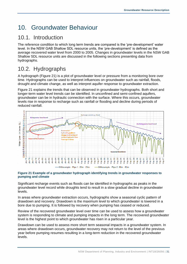
10.2. Hydrographs A hydrograph (Figure 21) is a plot of groundwater level or pressure from a monitoring bore over time. Hydrographs can be used to interpret influences on groundwater such as rainfall, floods, drought and climate change, as well as interpret aquifer response to groundwater extraction.
Figure 21 explains the trends that can be observed in groundwater hydrographs. Both short and longer-term water level trends can be identified. In unconfined and semi-confined aquifers, groundwater can be in hydraulic connection with the surface. Where this occurs, groundwater levels rise in response to recharge such as rainfall or flooding and decline during periods of reduced rainfall.
Figure 21 Example of a groundwater hydrograph identifying trends in groundwater responses to pumping and climate
Significant recharge events such as floods can be identified in hydrographs as peaks in the groundwater level record while droughts tend to result in a slow gradual decline in groundwater levels.
In areas where groundwater extraction occurs, hydrographs show a seasonal cyclic pattern of drawdown and recovery. Drawdown is the maximum level to which groundwater is lowered in a bore due to pumping. It is followed by recovery when pumping has ceased or reduced.
Review of the recovered groundwater level over time can be used to assess how a groundwater system is responding to climate and pumping impacts in the long term. The recovered groundwater level is the highest point to which groundwater has risen in a particular year.
Drawdown can be used to assess more short term seasonal impacts in a groundwater system. In areas where drawdown occurs, groundwater recovery may not return to the level of the previous year before pumping resumes resulting in a long-term reduction in the recovered groundwater levels.

Groundwater Resource Description
NSW Department of Planning, Industry and Environment | INT18/26056 | 32
10.3. Review of groundwater levels Representative hydrographs of five monitoring sites for NSW GAB Surat SDL resource unit and one monitoring site for NSW GAB Warrego Shallow SDL resource unit have been presented below. The location of these monitoring sites is shown in Figure 20. Each hydrograph is displayed on the same scale for ease of comparison.
None of the monitoring bores are located near areas where significant extraction takes place in the WRP area. Therefore, the hydrographs show groundwater levels that reflect climatic variations rather than the impacts of extraction.
Monitoring bore GW036698 is located approximately 2.4 km south of Macintyre River, west of Goondiwindi. The hydrograph (Figure 22) shows the long-term trend of groundwater level is generally stable in this area.
Monitoring bore GW036198 is located about 2 km north of Gingham water course and approximately 200 m away from a stock and domestic bore. Hydrograph (Figure 23) shows the two aquifers where water levels are monitored, are in hydraulic connection. There is a steady decline in water level in both aquifers. The mild water level fluctuation in the deep aquifer is attributed to the extraction from the nearby stock domestic bore.
Hydrograph (Figure 24) of monitoring bore GW036882 that is located approximately 250 m away from the Barwon River shows that shallow aquifer is in hydraulic connection with the river and responds to seasonal river flow. It also shows a downward leakage from shallow aquifer to deep aquifer in this area. The long-term trend of groundwater level is stable in both shallow and deep aquifers.
Monitoring bore GW036883 is located near the confluence of the Macquarie and Castlereagh Rivers and the monitoring bore GW036884 is located near the Barwon River. Hydrographs of both bores (Figure 25 and Figure 26) show the fluctuation of groundwater level due to river recharge associated with flooding in these areas. The long-term trend of groundwater level is stable in both bores.
Monitoring bore GW096105 is in the NSW GAB Warrego Shallow SDL resource unit and there is no nearby groundwater extraction. Hydrograph (Figure 27) shows the long-term trend of groundwater level is stable and minor fluctuation in the groundwater level is attributed to the climatic variations over the time.
Figure 22 Hydrograph for monitoring bore site GW036698

Groundwater Resource Description
NSW Department of Planning, Industry and Environment | INT18/26056 | 33
Figure 23 Hydrograph for monitoring bore site GW036198
Figure 24 Hydrograph for monitoring bore site GW036882
Figure 25 Hydrograph for monitoring bore site GW036883
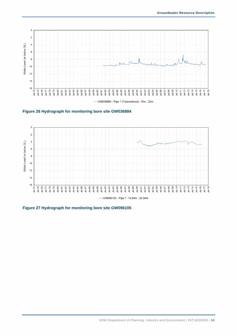
Groundwater Resource Description
NSW Department of Planning, Industry and Environment | INT18/26056 | 34
Figure 26 Hydrograph for monitoring bore site GW036884
Figure 27 Hydrograph for monitoring bore site GW096105

Groundwater Resource Description
NSW Department of Planning, Industry and Environment | INT18/26056 | 35
References ANZECC & ARMCANZ. (2000). National Water Quality Management Strategy - Paper No. 4,
Australian and New Zealand Guidelines for Fresh and Marine Water Quality Volume 1. Canberra: Commonwealth of Australia.
ANZECC & ARMCANZ. (2013). National Water Quality Management Strategy. Guidelines for Groundwater Quality Protection in Australia. Australian Government.
Aquatic Ecosystems Task Group. (2012). Aquatic Ecosystems Toolkit. Module 3: Guidelines for Identifying High Ecological Value Aquatic Ecosystems (HEVAE), Australian Government. Canberra, ACT: Department of Sustainability, Environment, Water, Population and Communities.
Australian Bureau of Statistics. (2017). National Census Data 2016. Retrieved from http://www.censusdata.abs.gov.au/census_services/getproduct/census/2016/quickstat
Bureau of Meteorology. (2008). Climate. Retrieved from Maps of average conditions: http://www.bom.gov.au/climate/averages/maps.shtml
Bureau of Meteorology. (2017). Climate Data Online. Retrieved November 1, 2017, from http://www.bom.gov.au/climate/data
Dabovic, J., Raine, A., Dobbs, L., & Byrne, G. (In prep). A method to assign ecological value to high probability groundwater dependent vegetation ecosystems in NSW. NSW Department of Primary Industries Water.
Department of Planning and Infrastructure. (2012). Upper Hunter Strategic Regional Land Use Plan. State of New South Wales.
DLWC. (1999). A proposal for updated and consolidated water management legislation for New South Wales - a white paper. NSW Department of Land and Water Conservation.
DPI Water. (2015). Macro water sharing plans - the approach for groundwater. NSW Department of Primary Industries, Office of Water.
DPI Water. (2016). Methods for the identification of high probability groundwater dependent vegetation ecosystems. NSW Department of Primary Industries.
DPI Water. (2017). NSW Great Artesian Basin Shallow Water Resources Plan (GW13). Status and Issues Paper. NSW Department of Primary Industries.
Gallant, J., Dowling, T., Read, A., Wilson, N., & Tickle, P. (2009). 1 second SRTM Level 2 Derived Digital Surface Model v1.0. Geoscience Australia, Commonwelth of Australia.
Gates, G., & O'Keefe, V. (1997 Unpublished). A brief paper on groundwater management in NSW. NSW Department of Land and Water Conservation.
MDBA. (2014). Basin-wide environmental watering strategy. Murray-Darling Basin Authority.
MDBA. (2016). Plain English summary - proposed Basin Plan amendments. Murray-Darling Basin Authority.
MDBA. (2017, October). Catchments. Retrieved November 2017, from https://www.mdba.gov.au/discover-basin/catchments/
NOW. (2011). Water Sharing Plan for the NSW Great Artesian Basin Shallow Groundwater Sources - Background document. NSW Office of Water.
NOW. (November 2011). Water Sharing Plan. Intersecting Streams Unregulated and Alluvial Water Sources - Background document. NSW Office of Water.
NSW Governement. (2008). Water Sharing Paln for the NSW Great Artesian Basin Groundwater Sources 2008. NSW Parliamentary Counsel's Office.

Groundwater Resource Description
NSW Department of Planning, Industry and Environment | INT18/26056 | 36
NSW Government. (2011). Water Sharing Plan for the NSW Great Artesian Basin Shallow Groundwater Sources 2011. NSW Parliamentary Counsel's Office.
OEH. (2014). Far West Climate change snapshot. Sydney South: NSW Office of Environment & Heritage.
OEH. (2014). New South Wales Climate change snapshot. Sydney: NSW Office of Environment and Heritage.
Ransley, T. R., & Smerdon, B. D. (2012). Hydrostratigraphy, hydrogeology and system conceptualisation of the Great Artesian Basin. A technical report to the Australian Government from the CSIRO Great Artesian Basin Water Resource Assessment. CSIRO Water for a Healthy Country Flagship, Australia.
Smart, R. (2016). User guide for land use of Australia 2010 - 2011. Australian Bureau of Agricultural and Resource Economic and Sciences, Commonwealth of Australia.
Watkins, J. J., & Meakin, N. S. (1996). Explanatory Notes - Nyngan and Walgett Geological Sheets 1:250 000. Geological Survey of New South Wales.