groundwater study of the narrogin townsite
TRANSCRIPT

Research Library Research Library
Resource management technical reports Natural resources research
3-2004
Groundwater study of the Narrogin townsite Groundwater study of the Narrogin townsite
Edward K. Crossley
Follow this and additional works at: https://researchlibrary.agric.wa.gov.au/rmtr
Part of the Agriculture Commons, Natural Resources Management and Policy Commons, Soil Science
Commons, and the Water Resource Management Commons
Recommended Citation Recommended Citation Crossley, E K. (2004), Groundwater study of the Narrogin townsite. Department of Primary Industries and
Regional Development, Western Australia, Perth. Report 256.
This report is brought to you for free and open access by the Natural resources research at Research Library. It has been accepted for inclusion in Resource management technical reports by an authorized administrator of Research Library. For more information, please contact [email protected].
RESOURCE MANAGEMENT TECHNICAL REPORT 256
GROUNDWATER STUDY OF THE NARROGIN TOWNSITE
Edward K Crossley
March 2004

ISSN 1039-7205
Resource Management Technical Report 256
Groundwater study of the
Narrogin townsite
Edward K Crossley
March 2004

NARROGIN GROUNDWATER STUDY
2
Disclaimer The contents of this report were based on the best available information at the time of publication. It is based in part on various assumptions and predictions. Conditions may change over time and conclusions should be interpreted in the light of the latest information available.
For further information contact Mr Mark Pridham Rural Towns Program Manager Department of Agriculture Locked Bag 4 Bentley Delivery Centre WA 6953 Telephone (08) 9368 3333
State of Western Australia 2004

NARROGIN GROUNDWATER STUDY
3
Summary A groundwater study was carried out in the Narrogin townsite in April 2002, aimed at providing technical information to develop a salinity management strategy.
The study consisted of a drilling investigation and expansion of the existing piezometer network,
Fifty-six piezometers, three observation bores and a production bore were installed at 30 sites within the townsite. Maximum depth to bedrock was 33 metres and was between 20 and 33 m at seven deep sites, 10 and 20 m at 16 sites and within 9 m at five sites.
The regolith revealed by drilling comprised both felsic and mafic saprolite profiles. This is consistent with aerial photography interpretation and geological mapping of the area, which indicates the presence of complex geology of fracture zones and small dykes associated with a portion of the Binneringie dyke that passes through the southern margin of the town.
In June 2002, groundwater was within 1.5 m of ground level in all bores adjacent to the Narrogin Brook, north of the racetrack. On lower slopes, watertables were between 2 and 3 m below ground and on mid-slopes greater than 3 m below ground.
The major source of recharge driving groundwater problems in Narrogin appears to originate within the town. Imported scheme water, equivalent to 35 per cent of average annual rainfall, makes up approximately 1000 ML of the total 2790 ML of water entering Narrogin annually.
Groundwater salinity is a concern requiring management to prevent serious problems in the short to medium term (5 to 20 years). Areas at greatest risk of shallow groundwater and associated problems are mainly in valley floor and lower slope positions; however shallow perched groundwater causes seasonal waterlogging annually on mid and lower slopes.
This report contains recommendations to be developed within a salinity and water management strategy that integrates recharge and discharge options. Groundwater monitoring should continue to build a database that will better define the groundwater system and indicate the effectiveness of management strategies as they are implemented.
.

NARROGIN GROUNDWATER STUDY
4
Contents
1. Introduction and background ....................................................................... 5 1.1 The town of Narrogin .................................................................................... 5
1.2 Description of the catchment ........................................................................ 6
1.3 Geology ........................................................................................................ 6
1.4 Climate ......................................................................................................... 6
1.5 Hydrogeology ............................................................................................... 9
1.6 Natural drainage ........................................................................................... 9
1.7 Water supply and disposal ......................................................................... 10
2. Hydrogeology investigation ........................................................................ 11 2.1 Previous investigations............................................................................... 11
2.2 Method ....................................................................................................... 11
2.3 Results ....................................................................................................... 15
3. Interpretation and discussion of results .................................................... 21 3.1 Recharge.................................................................................................... 21
3.2 Groundwater flow systems ......................................................................... 22
4. Conclusions.................................................................................................. 25 4.1 Salinity management options...................................................................... 25
5. Recommendations ....................................................................................... 26 5.1 Revegetation options.................................................................................. 26
5.2 Engineering options.................................................................................... 26
5.3 Conservation, community action and other options .................................... 27
6. Acknowledgments........................................................................................ 28
7. References.................................................................................................... 28
8. Appendix – Drill logs.................................................................................... 29

NARROGIN GROUNDWATER STUDY
5
1. Introduction and background
The Rural Towns Program undertook a groundwater study of Narrogin townsite in 2002 as part of a larger investigation that covered nine towns and aimed to provide the technical basis on which towns could develop salinity management strategies.
The study consisted of a drilling program, establishment of a piezometer network and initial monitoring of watertable depth and salinity. This report documents the background information for the town and its catchment (Section 1), results of the hydrogeological investigation (Sections 2, 3 and 4), and recommends steps for managing the town's salinity risk effectively (Sections 5 and 6).
1.1 The town of Narrogin
Narrogin (117º 11’E; 32º 56’S) is 205 km south-east of Perth on the Great Southern Highway (Figure 1-1). The town has a population of around 4,700 and is a regional centre for a number of government departments and agricultural service industries. Government departments with a presence include Agriculture, Conservation, Public Health, Main Roads, Westrail and Education. Narrogin is the largest regional centre between Perth and Katanning.
Figure 1-1. Regional setting of Narrogin townsite
Narrogin supports an export abattoir, grain handling and seed businesses, and intensive livestock industries based on poultry, cattle and pigs. A large brick works

NARROGIN GROUNDWATER STUDY
6
supplies Perth and the region. It is the proposed location for an integrated wood processing facility based on oil mallee plantings established by Western Power.
Narrogin joined the Rural Towns Program following concern with salinity along the Narrogin Brook and rising damp causing damage to masonry in residences and deterioration of sporting surfaces.
1.2 Description of the catchment
Narrogin lies in the upper portion of the Narrogin Brook Catchment. The area of catchment upslope is 2430 hectares. The town straddles Narrogin Brook just below the confluence of its three tributaries. The catchment is at its narrowest within the town, with a distinct narrowing of the valley adjacent to Fortune Street and again at the southern edge of town where the brook has cut through a ridge associated with the Binneringie dyke (see Section 1.3). Downstream, the brook is a meandering and often braided stream within the much broader and flatter Narrogin Valley. Figure 1-2 illustrates the catchment area for Narrogin.
Clearing for agriculture was mostly completed by 1912. Approximately 340 ha (~14%) of the catchment remains uncleared, most ungrazed by domestic animals and all of it upslope of the town. The townsite itself occupies 14.6% (355 ha).
The catchment elevation ranges from 335 m AHD at the lower end to 430 m AHD at the microwave repeater station hill at the upper, northern extent. Ridges at the western and eastern town boundaries rise to 410 and 390 m AHD respectively.
1.3 Geology
The geology is primarily fine- to coarse-grained granite with some mica-rich granites. Remnants of lateritic duricrust (cemented ironstone gravel) occur on the catchment divide, interspersed with outcropping granite and dolerite which extend onto the mid-slopes. An extension of the Binneringie dyke passes along the southern edge of the town. This complex dyke and fracture system comprise dolerites and rocks altered by contact and low grade burial metamorphism (Chin 1986). A number of lineaments transverse to the Binneringie complex are evident in aerial photos. These appear to be (mainly) dolerite dykes. Figure 1-3 shows lineaments visible in aerial photography. Where housing and street development masks the presence of lineaments these were inferred from strong lineaments visible on agricultural land.
1.4 Climate
Narrogin receives an average of 503 mm of rainfall each year of which 396 mm falls between May and November (Bureau of Meteorology 2001). Rainfall recorded in 2000 was less than could be expected in 50% of years and in 2001 rain received was lower than in 90% of years. June 2001 rainfall was the lowest on record since 1893. Annual evaporation estimates range from 1646 mm to 1896 mm (Luke et al. 1988). Mean daily monthly and annual evaporation rates and rainfall statistics are shown in Table 1-1. Figure 1-3 illustrates the differences between 2000, 2001 and average monthly rainfall.

NARROGIN GROUNDWATER STUDY
7
Figure 1-2. Location of Narrogin townsite within its catchment

NARROGIN GROUNDWATER STUDY
8
Table 1-1. Monthly rainfall and evaporation data
Rainfall (mm) Jan Feb Mar Apr May Jun Jul Aug Sep Oct Nov Dec Annual
Mean monthly 12.3 16.7 20.7 29.5 64.5 89.8 89.3 68.6 47.1 33.1 17.8 13.2 502.7
Highest monthly
155.4 237.2 127.5 120.7 167.2 300.4 243.3 185.2 121.4 127.6 79.4 94.6
Highest daily 150.0 115.3 114.3 63.2 68.3 71.1 81.3 42.4 35.6 49.4 38.1 57.8
2001 2.8 11 14 0.2 63.0 16.1 56.5 84 35.8 10.4 32.2 40.0 366.0
2000 133.4 0 17.3 12.8 3.8 58.6 107.7 60.6 33.6 3.2 11.6 0.6 443.2
Minimum in 90% of years
0 0 1 3 20.6 45.7 41.8 35.4 17.8 11.6 1.8 0 377.4
Minimum in 50% of years
3.1 6.4 13.9 24.3 61.2 78.8 80 64.8 43.6 25.8 14.2 6.4 511.6
Minimum in 10% of years
33.1 47.8 63.8 63.3 110.7 148.2 148.6 110.7 77 60.9 35.2 31.6 655.8
Mean daily evaporation
8.8 7.7 6 3.5 2.3 1.6 1.5 2 2.8 4.2 5.9 8.0 4.5
Mean monthly evaporation
314 257 217 126 81 50 51 64 99 143 207 286 1896
0
20
40
60
80
100
120
140
J F M A M J J A S O N D
Month
Rai
nfal
l (m
m)
2000 Rainfall2001 RainfallMean Monthly Rainfall
Figure 1-3. Mean monthly rainfall data for Narrogin

NARROGIN GROUNDWATER STUDY
9
1.5 Hydrogeology
The hydrogeology of Narrogin had not been described prior to the Community Bores Program. The catchment is small so the groundwater flow systems within it are likely to be localised. In aerial photographs, numerous lineaments are evident in farmland surrounding the town; these seem often to be associated with discharge areas along the drainage lines suggesting a high degree of influence of these geological features on aquifers and groundwater flow. It’s likely that groundwater discharge is directed by these lineaments into the Narrogin Brook and its tributaries. In other studies these structures have been shown to be groundwater carriers and/or barriers depending on their orientation in relation to the groundwater gradient (Engel et al. 1987, McFarlane et al. 1987, Lewis 1991, Clarke et al. 2000, Ghauri 2002).
Two constrictions within the townsite are likely to impede groundwater flow through the town. One is associated with a spur that extends from the west to the Narrogin Brook, ending near the eastern end of Fortune Street; the other constriction occurs at the bottom of the town’s catchment where the Brook breaches the Binneringie dyke extension (see Figures 1-4 and 2-1).
Stream monitoring through the Ribbons of Blue program indicates a steady increase in salinity in the Narrogin Brook though this could be due to low flows in recent dry seasons. More frequent monitoring and a longer data record are required to determine whether salinity changes are due to long-term trends, seasonal variation or measurement error. A dam built in 1906 by the WA Government Railways adjacent to the Narrogin Pool north-east of the present Westrail offices was too saline for use in steam engines by the 1920s (M. White, pers. comm.) so groundwater salinity has been an emerging problem for at least 80 years.
1.6 Natural drainage
Narrogin Brook is a fourth order stream as it flows through the town. Drainage lines are initially relatively steep (2–3%) in the upper slopes but the gradient decreases before their confluence into the Narrogin Brook. The brook has a gradient of 0.6% as it passes through town. Below Narrogin the gradient is reduced further to 0.4%.
Narrogin Brook has been subject to ‘training’ in the past to reduce the risk of flooding. Flooding occurred frequently during the 1910s and the reach running through town was straightened and lined with concrete by the 1930s. Weirs were constructed in the 1930s to control flow. Wetlands adjacent to the brook were progressively reclaimed by the 1950s (M. White, pers. comm.). Other minor tributaries that originally flowed into the brook from within the town have been reconstructed as stormwater drains and lined in places. Their efficiency has diminished over time due to channel silting.
Aerial photographs show that the land adjacent to the Narrogin Brook and its tributaries is subject to prolonged waterlogging, particularly above stream confluences. These sites, particularly along the north and north-east branches above town, have become congested with reeds (Juncus acutus and Typha spp.).

NARROGIN GROUNDWATER STUDY
10
1.7 Water supply and disposal
Narrogin’s total consumption of scheme water in 2000-01 was 1020 ML, an equivalent of 287 mm extra water over the town. Virtually all residences are connected to mains sewerage. In 2000-01 the Water Corporation treated 372 ML of wastewater at its plant on the southern (downstream) side of town. Of this, 142 ML were reused on parks and gardens, and 230 ML were discharged from the treatment plant directly into the Narrogin Brook (unpublished Water Corporation figures).
Figure 1-4. Dykes and lineaments from geological mapping and aerial photography

NARROGIN GROUNDWATER STUDY
11
2. Hydrogeology investigation The hydrogeology investigation consisted of a drilling program to install a groundwater monitoring network and obtain initial readings from the monitoring program. This section details the methods used to undertake the investigation.
2.1 Previous investigations
Two preliminary investigations had been undertaken in Narrogin prior to the Community Bores program. In the first, three observation bores were installed along the flood plain of the Narrogin Brook in Gnarogin Park, between Kipling and Herald Streets in 1994. These bores were monitored at irregular intervals by the Ribbons of Blue program from 1998 until 2001. Water levels in these bores showed only seasonal fluctuations, with no obvious long-term trend, however regular monitoring over at least the next five years would be required to confirm this. Groundwater in these bores is within 1 m of ground level during winter and spring.
Groundwater electrical conductivity measured in these bores in 2000 was slightly higher than that in the Narrogin Brook. Values ranged between 380 and 1640 mS/m for the bores and between 620 and 1170 mS/m for the brook measured south of the CBH facility and Gnarogin Park.
The second investigation was implemented as a precursor to the Community Bores Project. In 2001 five sites were drilled with an auger rig and bores installed to determine if a salinity hazard existed through town. In each case the bores had a 2 m slotted section at their bases, and were completed with gravel pack and bentonite plug. These bores, except for one that was drilled to basement, were assigned an ‘I’ suffix as they are measuring pressures intermediate to the shallow and deep aquifers. The names of the five bores drilled in 2001 were given the same site name as bores drilled at their locations in 2002 but with the prefix 01 to indicate the year they in which they were drilled.
Only one of the bores drilled in 2001 in a lower slope position had groundwater levels that represented a current salinity hazard. This bore (01NA05I, at site 02NA05) registered a watertable at 1.5 m below ground level in June 2001; the remainder were at least 3.5–5 m below ground level.
The Waters and Rivers Commission’s AQWABASE database contained no reference to bores within the town boundary. Figure 2-1 indicates the position of Community Bores drilled in 2001-02 in Narrogin.
2.2 Method
The following information was reviewed prior to selecting sites for nested piezometers and to assist hydrogeological interpretations:
• 2–metre elevation contours showing natural surface water drainage (produced by Spatial Resources Group, Department of Agriculture);
• 1:250,000 regional geology mapping (Chin 1986);

NARROGIN GROUNDWATER STUDY
12
• 1:25,000 DOLA. colour aerial photography (1996);
• 1:16,000 DOLA colour aerial photography (2000).
Drilling for the Community Bores Project was carried out between 4 April and 2 May 2002. Fifty six piezometers and three observation bores were installed at 30 sites. A production bore was installed behind the Narrogin Shire offices and an aquifer test was undertaken in August 2003 (Hopgood 2004). Observation bores were installed in shallow holes <4 m where seasonal unconfined perched aquifers were expected.
Figure 2-1. Location of bores in Narrogin townsite

NARROGIN GROUNDWATER STUDY
13
2.2.1 Drill site selection
Drill sites were selected to determine depth to bedrock and regolith and aquifer characteristics of all landscape units within the Narrogin townsite. Where possible, sites were chosen 250 to 500 m apart to provide adequate coverage and monitoring density across town for groundwater modelling purposes. Sites were moved slightly where necessary to avoid town infrastructure (power lines, telephone cables and water and sewerage facilities).
At most sites, shallow and deep bores were installed to determine the magnitude of vertical heads and the direction of groundwater flow through the town. At sites 00NA18, 02NA22 and 01NA25 where bedrock was encountered at 3.6, 3.4 and 3.2 m respectively, no observation bores were installed. At sites 02NA05 and 02NA17 single deep bores were installed to complete nests with bores drilled in 2001. Intermediate bores were also installed to monitor intermediate depth aquifers at 02NA07 and 02NA28.
The production well at 02NAPB behind the Shire offices was installed after drilling a pilot hole that sustained a flow rate of approximately 1 L/s during air lifting to develop the bore. This bore will be used subsequently in an aquifer test to evaluate groundwater pumping as a salinity management strategy for Narrogin. Piezometer nests were installed at four sites in two orthogonal transects, intersecting at 02NAPB to monitor the aquifer test. The nests were installed at 24, 40 and 70 m from 00WAPB1 on the southern transect and 30 m on the eastern transect to provide adequate coverage for a 72-hour aquifer test.
The Community Bore (02NACB) was located in a prominent site on Ensign Street opposite Coles car park.
2.2.2 Drilling methods
Monitoring and production bores were drilled by contractor Austral Drilling using a reverse circulation air-core rig with a 125 mm-diameter bit. Composite samples were collected at 1-metre intervals from a cyclone attached to the rig's sample hose, bagged and logged. The production bore was drilled using mud-rotary methods with a 250 mm-diameter drill bit.
2.2.3 Piezometer construction
The monitoring sites were constructed with 50 mm-diameter class 12 PVC casing with 2 m slotted screen at their base (0.5 mm-wide slots). A gravel pack of '8 x 16' graded sand (about 1.2-2.4 mm diameter) was placed in the annulus extending to just above the slots. A bentonite plug was installed above the gravel pack.
Monitoring bores were constructed by running PVC casing down the inner tube of the drill string at the completion of each hole. The drill rods were then removed and the gravel pack and cement plug installed. In a number of cases the PVC casing was filled with water. The extra weight allowed the PVC to remain at the bottom of the hole while the rods were removed and the gravel pack and grouting were installed in the usual way. In such cases, groundwater salinity observations made immediately after installation were rejected.

NARROGIN GROUNDWATER STUDY
14
All piezometers and observation bores were developed by air-lifting with a high capacity air compressor following construction. Developing was continued until clear water flowed from the bore, though often some fine sand was still being produced.
The production bore was installed with 155 mm-diameter PVC casing which was slotted (1.0 mm-wide slots) from 5 to 17 m below ground. The gravel pack of '8 x 16' graded sand was placed to cover the slots. Bentonite pellets were placed over the gravel pack and the remainder of the annulus backfilled with graded sand.
The production bore was developed by air-lifting with the drill rig's compressor for 8 hours. At the end of development, fine sand was still evident in the bore water, indicating that a choice of finer slots and gravel pack would have been preferable at this site.
All bores were completed with lockable steel headworks.
2.2.4 Groundwater depth and electrical conductivity measurements
Groundwater and electrical conductivity (EC) for all bores drilled in 2001 and 2002 were monitored on 18 April and 13 June 2002 and then at quarterly intervals. Quarterly monitoring of these bores by the Department of Agriculture will continue until at least June 2005.
The electrical conductivity values of the water samples were measured in the field using a WTW LF330 downhole probe.
2.2.5 Surveying
Locations (eastings and northing) and elevations of piezometers were surveyed using a differential global positioning system which was accurate to ±10 cm horizontally and vertically.

NARROGIN GROUNDWATER STUDY
15
2.3 Results
Some of the piezometer and groundwater details are listed in Table 2-1. Figures 2-3 to 2-6 illustrate variations in groundwater levels and EC across the townsite.
2.3.1 Profile descriptions
The drilling program established that Narrogin sits on an in situ weathered granitoid regolith overlain by up to 8 m of colluvium on lower slopes and in the valley up to 12 m of alluvial sediments near the railway crossing at Herald Street (though some of this may be landfill deposited in the early 1900s during wetland reclamation to expand the railway shunting yards). Bedrock geology varies from gabbro, dolerite and mica-rich granodiorite associated with the Binneringie extension in the southern end of town to granodiorite and granite through the main part of town.
Depth to bedrock ranged from between 3.2 and 34 m averaging 16.1 m. The median depth was 14.9 m. Elevation of the bedrock surface ranged from 305 to 360 m above Australian Height Datum (AHD). Bedrock was shallowest in the vicinity of Moore Street at 02NA22 (3.4 m) and east of the Department of Agriculture at 01NA25 (3.2 m). At one site just north-east of the Department of Agriculture building bedrock was encountered at 2 m and the hole was abandoned. A plan to establish a production bore at the rear of commercial premises opposite and north of the Coles supermarket was also abandoned when bedrock was encountered 9 m below ground, 9 m higher than 02NA10, 70 m away.
Median thickness of the saprolite aquifer (permeable saprolite clay and saprock) was 5 m and ranged from less than 0.5 to 13 m at St Matthews School, suggesting that this aquifer has a relatively high transmissivity in places. Quartz and feldspar particles formed 40-60 % of this layer and ranged in diameter up to 10 mm, averaging 3-4 mm. At many sites weathering of saprolite overlying bedrock was well advanced and comprised coarse to gritty clays, rich in mica and consequently the saprolite at these sites was assumed to have a lower permeability. The cross-sections shown in Figures 2-3 to 2-6 illustrate the key elements of the drill logs and watertable position along four transects within Narrogin town.
Dolerite or gabbro was encountered at four sites: 02NA02, 02NA06, 02NA13 and 02NA18. Faulting and local metamorphosis was evident from the occurrence of green fault rocks or shearing of basement rock at nine sites (02NA07, 02NA08, 02NA12, 02NA15, 02NA16, 02NA17, 02NA19, 02NA20 and 02NAPB), indicative that these sites also were located on or near lineaments.
Minor siliceous and ferruginous hardpans were encountered at varying depths at 12 sites, mainly adjacent to drainage lines and on lower slopes in colluvial and alluvial deposits. Given their patchy occurrence, they are unlikely to be major impediments to recharge and discharge processes. The most significant hardpans were at 02NA11 (0.5 m thick), 02NA05 (1 m), 02NACB (1.5 m) and 02NA19 (3 m thick). These hardpans are apparently permeable to some extent; as they contained iron-stained pores and moisture (evident with the aid of a hand lens).

NARROGIN GROUNDWATER STUDY
16
Figure 2-2. Section along Clayton Rd transect to Narrogin Brook
Figure 2-3. Section along Foxes Lair transect to Narrogin Brook

NARROGIN GROUNDWATER STUDY
17
Figure 2-4. Section along east Narrogin transect to valley floor
Figure 2-5. Section along Narrogin Brook transect

NARROGIN GROUNDWATER STUDY
18
2.3.2 Groundwater levels
Table 2-1 lists the groundwater level depths and EC in the piezometers when measured on 13 June 2002.
Depth to watertable is generally related to landscape position, i.e. in lower positions watertables were generally close to ground level and became deeper upslope. Exceptions occurred on slopes where watertables measured in bores on shallow bedrock (e.g. 02NA22D in Moore Street) were closer to ground level than bores in deeper regolith and similar landscape position. Groundwater was within 1.5 m in all bores along the Narrogin Brook downstream from 02NA06. On lower slopes, watertables were 2 to 3+ metres and on mid-slopes more than 3 m below the surface.
Nine sites (shown in bold italics in Table 2.1) had an upward gradient (i.e. the water level measured in deep piezometers was above the shallow watertable as measured in shallow bores). Upward gradients varied from 0.002 to 0.019. The largest upward gradient was at 02NA19 next to the Narrogin Primary School oval, where the piezometer level was 0.5 m above ground. Four sites (02NA02, 02NA04, 02NA26, 02NA28) on the flood plain of the Narrogin Brook, had shallow and deep levels within 1.5 m of ground level; one (02NA12), at the foot of the slope on Moss Street, was within 2 m and four (02NA10, 02NA11, 02NA13 and 02NA17) were 3 to 4.5 m below ground level.
At three sites (02NA03, 02NA27 and 02NA06) with depth below ground within 1.5 m, there was no vertical gradient between shallow and deep bores (levels were equal in both bores). Two sites with only deep bores had levels 3 m or deeper, (02NA18D was dry). At eight other sites with dry shallow bores, the deep bore levels were deeper than 3 m below ground except 02NA14, which was 2.2 m below ground level.
Only four sites had downward gradients, 02NA01, 02NA05, 02NA07 and 02NA24.
Eleven shallow bores and one piezometer remained dry at June 2002. Nine of the shallow bore sites were on mid and upper slope positions, two on lower slope positions. The piezometer was on a bedrock high in a mid-slope position.
2.3.3 Groundwater electrical conductivity
Electrical conductivity measured in shallow bores was highly variable and ranged from <200 mS/m at two valley sites and one lower slope site to 2800 mS/m at a break of slope site (02NA19). All other shallow bores were less than 1290 mS/m with a median value of 796 mS/m. The least conductive groundwaters were measured in shallow bores in valley and lower slope positions though in five other bores in similar positions EC values were among the highest (over 1000 mS/m).

NARROGIN GROUNDWATER STUDY
19
Table 2-1. Piezometer site, drilling, construction and electrical conductivity
Bore hole Ground elevation
above AHD (m)
Depth drilled
Screen interval above
AHD (m)
Groundwater level depth
bgl (m) 13/6/2002
Groundwater elevation
above AHD
(m)
EC 13/6/2002 (mS/m)
Estimated flow
(L/sec)
02NA01D 337.1 17.52 319.6-321.6 1.43 335.7 1679 Negligible 02NA01Ob 337.1 3.16 334.0-336.0 1.05 336.1 180 02NA02D 336.1 10.37 325.7-327.7 0.39 335.7 987 Negligible02NA02Ob 336.1 3.95 332.1-334.1 0.91 335.2 1039 02NA03D 339.2 17.99 321.3-323.3 1.46 337.8 1296 0.5 02NA03Ob 339.2 4.90 334.3-336.3 1.47 337.8 55 02NA04D 340.2 11.25 329.0-331.0 0.88 339.3 944 Negligible02NA04S 340.3 4.48 335.8-337.8 1.21 339.0 725 02NA05D 343.8 19.05 324.8-326.8 3.12 340.7 507 0.5 01NA05I 344.1 5.57 338.5-340.5 1.70 342.4 164 02NA06D 346.6 12.27 334.3-336.3 0.99 345.6 1275 Negligible 02NA06S 346.5 3.96 342.6-344.6 1.01 345.5 1237 02NA07D 352.8 29.27 323.5-325.5 2.28 350.5 1171 1 02NA07I 352.8 12.39 340.4-342.4 2.08 350.7 1068 02NA07S 352.7 5.51 347.2-349.2 1.98 350.7 798 02NA08D 364.6 20.34 344.2-346.2 3.69 360.9 1010 0.5 02NA08S 364.6 3.89 360.7-362.7 DRY dry 02NA09D 348.5 14.34 334.2-336.2 5.00 343.5 1462 Nil 02NA09S 348.5 3.98 344.5-346.5 DRY dry 02NA10D 342.8 14.87 328.0-330.0 3.43 339.4 1362 0.5 02NA10S 342.8 3.78 339.0-341.0 3.51 339.3 1880 02NA11D 343.6 27.44 316.2-318.2 3.89 339.7 818 2 02NA11S 343.6 3.92 339.7-341.7 DRY dry 01NA11I 343.6 8.11 335.5-337.5 3.95 339.7 1626 01NA11Ob 343.6 6.89 336.8-338.8 3.94 339.7 1295 02NA12D 348.8 12.41 336.4-338.4 1.65 347.1 379 Negligible02NA12S 348.8 4.07 344.7-346.7 1.86 347.0 472 02NA13D 360.3 7.66 352.6-354.6 3.01 357.2 1348 Negligible02NA13S 360.3 3.96 356.3-358.3 3.24 357.1 898 02NA14D 358.5 7.37 351.1-353.1 2.21 356.2 1154 Nil 02NA14S 358.5 2.96 355.5-357.5 DRY dry 02NA15D 344.3 20.00 324.3-326.3 3.45 340.9 2000 1.5 02NA15S 344.4 3.82 340.6-342.6 DRY dry 02NA16D 347.4 17.64 329.8-331.8 7.47 339.9 647 0.5 02NA16S 347.4 5.95 341.4-343.4 DRY dry 02NA17D 339.9 32.88 307.0-309.0 3.62 336.3 1538 Negligible01NA17I 340.2 6.53 333.7-335.7 4.54 335.7 954 02NA18D 344.9 3.58 341.4-343.4 DRY dry Nil 02NA19D 347.5 17.38 330.2-332.2 -0.50 348.0 1270 0.5 02NA19S 347.5 3.92 343.6-345.6 0.80 346.7 2850 02NA20D 355.2 20.5 334.7-336.7 3.79 351.4 924 1

NARROGIN GROUNDWATER STUDY
20
Bore hole Ground elevation
above AHD (m)
Depthdrilled
Screen interval above
AHD (m)
Groundwater level depth
bgl (m) 13/6/2002
Groundwater elevation
above AHD
(m)
EC 13/6/2002 (mS/m)
Estimated flow
(L/sec)
02NA20Ob 355.3 2.74 352.5-354.5 DRY dry 01NA20I 355.8 5.57 350.3-352.3 3.74 352.1 2690 02NA21D 352.3 29.55 322.7-324.7 3.13 349.1 1635 2 02NA21S 352.3 2.98 349.3-351.3 DRY dry 02NA22D 348.8 3.42 345.4-347.4 2.98 345.8 373 Nil 02NA23D 356.0 8.98 347.0-349.0 6.82 349.2 1233 Nil 02NA23S 356.0 4.90 351.1-353.1 DRY dry 02NA24D 342.0 26.94 315.0-317.0 1.94 340.0 1720 0.75 02NA24S 342.0 4.88 337.1-339.1 1.84 340.1 662 01NA25D 341.3 3.18 338.1-340.1 2.87 338.4 1355 Nil 02NA26D 339.2 14.75 324.5-326.5 1.28 337.9 1346 1 02NA26S 339.2 4.93 334.3-336.3 1.33 337.9 788 02NA27D 339.3 14.67 324.6-326.6 1.28 338.0 1289 1 02NA27S 339.3 5.39 333.9-335.9 1.30 338.0 1196 02NA28D 338.8 13.16 325.6-327.6 0.73 338.1 1335 0.5 02NA28I 338.8 9.00 329.8-331.8 0.87 337.9 1112 02NA28S 338.8 5.40 333.4-335.4 0.87 337.9 1248 02NAPB 339.2 16.88 322.3-334.3 1.18 338.0 1396 1.25 02NACB 341.8 8.47 333.3-335.3 2.9 338.9 495
Bores with data in bold italics have an upward gradient; AHD = Australian Height Datum; bgl = below ground level.
Deep groundwater sampled in all piezometers ranged from brackish to saline (400 to 2000 mS/m). The median EC value in deep bores was 1290 mS/m. In general, piezometers on the upper slopes had lower ECs than those on the valley floor and lower slopes. Only four piezometers in valley or lower slope positions (02NA04D, 02NA02D, 02NA11D and 02NA12D) had EC values less than 1000 mS/m.
At most sites EC of groundwater in observation and shallow bores was less than in deep piezometers.
2.3.4 Aquifer test
Aquifer test pumping carried out in August 2003 (Hopgood 2004) indicated that the hydraulic conductivity of the saprolite aquifer surrounding the production bore was approximately 6.4 m/day and had a transmissivity around 57 m2/d; the storage coefficient was 1.7 x 10⁻⁴. For the upper aquifer, transmissivity was calculated at 78 m2/d and specific yield 4.1 x 10⁻³. No value for hydraulic conductivity was calculated as the aquifer thickness was not known. Test pumping results suggest that production bore 02NAPB may be capable of a long-term discharge rate of 220 m3/day (2.6 L/sec) for an operational water level of about 6 m below ground level after six months of pumping (Hopgood 2004).

NARROGIN GROUNDWATER STUDY
21
3. Interpretation and discussion of results This section presents a discussion of the recharge, groundwater flow and discharge processes affecting Narrogin and gives an assessment of the salinity risk facing the town, based on the available information. Conclusions and recommendations are presented in Sections 5 and 6.
Monitoring data and field observations indicate that discharge areas within the town catchment are restricted to isolated sites on the mid and lower slopes, parts of the valley floor and within the riparian zone of the Narrogin Brook and its tributaries. Over the remaining much larger portion of the town and catchment, recharge conditions apply.
3.1 Recharge
Potential sources of groundwater recharge likely to affect groundwater levels in Narrogin occur:
• on upslope cleared land to the north, west and east and on rocky slopes to the south of town;
• within the town itself;
• from the Narrogin Brook when water levels are elevated.
3.1.1 Recharge under upslope land
On land upslope to the west of town, the potential for recharge is high in permeable soils and fractured rock surrounding outcropping bedrock. East of Narrogin Senior High School, on the east of town, recharge in the sandy lateritic remnants is likely to be high, however the area contributing to the Narrogin’s catchment seems to be small and discrete, and the amount of recharge entering aquifers beneath the townsite is considered insignificant.
Although cleared agricultural land north and west of Narrogin has a high recharge potential, due to the compartmentalised nature of the groundwater systems and the orientation of geological structures that appear to be groundwater carriers, groundwater discharges mainly into the Narrogin Brook tributaries upstream from town. Consequently, the impact within Narrogin, of recharge upslope of the town, is considered to be negligible.
Recharge in fractured rocky slopes to the south of town may be likely in wet periods, however, these areas are well vegetated and data from nearby bores (03NA11, 03NA12 and 03NA13) at the base of these slopes indicate that recharge from this area is not significant.
3.1.2 Recharge within Narrogin townsite
Within the townsite, potential sources of recharge include:
• direct infiltration of rainfall;

NARROGIN GROUNDWATER STUDY
22
• infiltration from drainage lines and unsealed drains, and run-off from slopes of the surrounding catchment;
• infiltration of scheme water used on gardens by residents or recycled water used to irrigate parks, gardens and sporting facilities;
• infiltration of run-off from roads, roofs and other hard surfaces into unsealed gutters; and
• infiltration from leaking water pipes, stormwater pipes and the recycled water storage dam.
Of the potential sources, recharge within the townsite itself is likely to contribute most to aquifers. In addition to the 503 mm annual rainfall received in Narrogin, around 40% of water supplied by Water Corporation (approximately 400 ML equivalent to 113 mm) is applied to gardens (Alan Herdman, Water Corporation, Narrogin, pers. comm.). Assuming an average annual recharge rate of 8% (rainfall plus scheme water applied to gardens), almost 50 mm of recharge would enter the groundwater system each year.
Recharge within the town during the recent run of dry seasons could be expected to be lower than recharge under average rainfall conditions. However, in parts of Narrogin overlying more permeable soils, or those with preferred flow recharge pathways (e.g. old root channels and fracture zones), infiltration and recharge may occur quite readily. Longer-term bore monitoring is required to indicate when and where most recharge occurs.
The impermeable heavy clay soils underlying parts of Narrogin may restrict recharge and lead to the formation of perched shallow watertables during wet periods. Compaction below streets and the railway line may impede throughflow in the upper part of the soil profile and help to maintain these seasonal perched watertables.
3.1.3 Recharge from Narrogin Brook
During periods of high flow in Narrogin Brook, when the water level in the creek is higher than the watertable, the brook can lose water to permeable sediments in the riparian zone and adjoining areas along the valley, recharging shallow watertables. Where the watertable is already relatively high in those areas, recharge caused by this process would put additional pressure on discharge areas.
3.2 Groundwater flow systems
The irregular bedrock topography, presence of geological structures such as mafic dykes and fracture zones suggest that groundwater flow systems in Narrogin are discontinuous to some degree. However, the degree of connection between adjacent aquifers is likely to be variable, so watertable responses to recharge will range from temporary rises that decay as aquifers drain, to sustained or permanent rises where groundwater flow is restricted.
Most of the groundwater flow occurs in the gritty and permeable saprolite layer overlying the bedrock. Transmissivity of this aquifer is variable and groundwater flow may be restricted by:

NARROGIN GROUNDWATER STUDY
23
• thinning of the permeable saprolite layer;
• presence of groundwater barriers; or
• bedrock highs.
Calculated results for transmissivity and hydraulic conductivity from test pumping are an order of magnitude higher than previously published values for weathered granite saprolite. Hopgood (2004) suggests this may be due to effect of leakage from the shallow aquifer during the pump test. However, while actual values may be lower, results from recovery test and data collected in monitoring bores were consistent and showed that in the area of influence of the production bore, the aquifer has both a high transmissivity and hydraulic conductivity.
The potentiometric surface, as illustrated in Figure 3-1 is a subdued reflection of the landscape topography and, despite the local influence of lineaments and irregular bedrock topography, general flow direction is orthogonal to the lines of equal pressure shown in the figure. (The lines on the periphery of Figure 3-1 are artefacts associated with the limited number of data sites, edge effects and the contouring package.)
MOSS
ST
JERSEY
FLO
YD
FORRESTST
ST
FLO
REA
T
ST
ENSIGN ST
CLAYTON
ST
STM
OO
RE
EAR
L
FED
ERAL
KIPLINGRD
ST
ST
ST
GLY
DE
WILLIAMS
FORREST
HANSARD
ST
ST
RD EGERTON
ST
EAR
L
ST
STLU
KIN
HERALD
FED
ERA
L
EAR
L
ST
ST
GR
EAT
SOU
THER
N H
WY
515000 515500 516000 516500 517000 517500
6355000
6355500
6356000
6356500
6357000
02ng01d
02ng02d
02ng03d
02ng04d02ng05d
02ng06d
02ng07d
02ng08d 02ng09d
02ng10d
02ng11d
02ng12d02ng13d
02ng14d
02ng15d
02ng16d
02ng17d
02ng18d
02ng19d02ng20d
02ng21d
02ng22d
02ng23d
02ng24d
01ng25d02ng26d02ng27d
02ngcb
02ng28d02ngpb
Figure 3-1. Potentiometric surface of deep bores (contours at 1 m intervals; heights in m AHD)

NARROGIN GROUNDWATER STUDY
24
As a consequence of reductions in transmissivity associated with bedrock highs (due to thinner regolith), waterlogging and seasonal inundation of house basements have been reported in mid-slope positions on both sides of the creek. Problems caused occur in the vicinity of the intersection of Havelock and Doney Streets and the western end of Sydney Hall Way. Similarly affected areas may occur elsewhere in Narrogin, but were not identified during this investigation.
Groundwater discharge at the junction of Glyde and Jersey Streets appears to be due to the presence of a geological structure. Piezometric pressure is above ground level at this site. In summer, salt efflorescence may be seen on the footpath opposite the bores. The creation of a groundwater mound in the vicinity results in annual waterlogging in a number of adjacent properties further up Jersey St.
Large discharge areas along the drainage lines (mainly on the upslope side of town) also appear to be associated with lineaments where they behave as groundwater carriers and barriers. Active seepage from the shallow watertable was observed during autumn 2003 along the unlined section of the main creek north of Clayton Rd.
3.2.1 Assessment of salinity risk
Shallow groundwater levels, within critical depths for evaporative discharge, and positive vertical gradients indicate a high salinity risk in the short and medium term (5-20 years) in the lower landscape positions. Currently, discharge areas are confined to the drainage line and discrete areas on valley and lower slope positions.
Groundwater modelling of similar landscapes, where recharge causes groundwater pressures to continue to rise, indicates that while discharge rates may increase significantly, the size of existing discharge areas (areas with a shallow watertable) may not expand much (George et al. 2001). Observations of similar landscapes suggest that groundwater discharge associated with dykes or bedrock highs could still appear on slopes and affect discrete areas. Salt-affected areas could still expand downslope from these areas without some form of intervention to control runoff of saline discharge.
Long-term groundwater records for the townsite will establish if the groundwater levels are stable or rising (and at what rate) and allow the future risk of salinity or other problems associated with shallow groundwater to be established.
NARROGIN GROUNDWATER STUDY
25
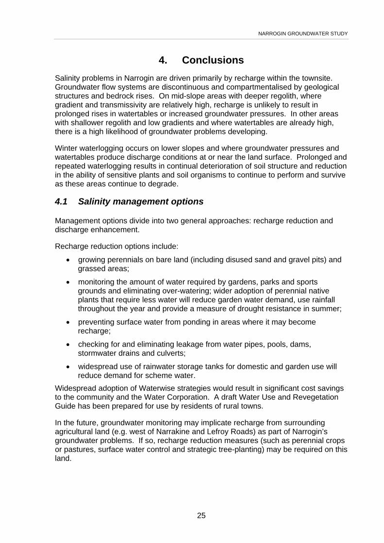
4. Conclusions
Salinity problems in Narrogin are driven primarily by recharge within the townsite. Groundwater flow systems are discontinuous and compartmentalised by geological structures and bedrock rises. On mid-slope areas with deeper regolith, where gradient and transmissivity are relatively high, recharge is unlikely to result in prolonged rises in watertables or increased groundwater pressures. In other areas with shallower regolith and low gradients and where watertables are already high, there is a high likelihood of groundwater problems developing.
Winter waterlogging occurs on lower slopes and where groundwater pressures and watertables produce discharge conditions at or near the land surface. Prolonged and repeated waterlogging results in continual deterioration of soil structure and reduction in the ability of sensitive plants and soil organisms to continue to perform and survive as these areas continue to degrade.
4.1 Salinity management options
Management options divide into two general approaches: recharge reduction and discharge enhancement.
Recharge reduction options include:
• growing perennials on bare land (including disused sand and gravel pits) and grassed areas;
• monitoring the amount of water required by gardens, parks and sports grounds and eliminating over-watering; wider adoption of perennial native plants that require less water will reduce garden water demand, use rainfall throughout the year and provide a measure of drought resistance in summer;
• preventing surface water from ponding in areas where it may become recharge;
• checking for and eliminating leakage from water pipes, pools, dams, stormwater drains and culverts;
• widespread use of rainwater storage tanks for domestic and garden use will reduce demand for scheme water.
Widespread adoption of Waterwise strategies would result in significant cost savings to the community and the Water Corporation. A draft Water Use and Revegetation Guide has been prepared for use by residents of rural towns.
In the future, groundwater monitoring may implicate recharge from surrounding agricultural land (e.g. west of Narrakine and Lefroy Roads) as part of Narrogin’s groundwater problems. If so, recharge reduction measures (such as perennial crops or pastures, surface water control and strategic tree-planting) may be required on this land.

NARROGIN GROUNDWATER STUDY
26
5. Recommendations The following recommendations should be developed in a salinity and water management strategy for Narrogin
5.1 Revegetation options
• Retain mature trees within the town. A single healthy tree can use around 200 L of soil water per day. If such a tree ‘sink’ is removed, the water that it would have used is added to the groundwater elevating groundwater pressure and increasing discharge. Vigorous trees on good sites (i.e. good soil water availability, adequate soil depth and low soil and groundwater salinity) may use 3.4 to 3.9 times annual rainfall (Greenwood et al. 1985), and when planted in sufficient numbers can lower watertables significantly.
• Consider groundwater salinities and watertable depths when planning revegetation through the town.
5.2 Engineering options
• The presence of sediment with inter-bedded layers of sands and clays suggests that the valley soils may be conducive to drainage. Hence drainage along the railway reserve may be successful and is worth further investigation. Covered drains would be preferable in the centre of town.
• Sports grounds receiving regular applications of recycled waste water should have sub-surface drainage installed to reduce recharge. It may be acceptable to discharge the drained water to the creek or stored for reuse, depending on salinity and nutrient content.
• Drainage could also be effective in residential areas and would be worth trialling in an area where waterlogging occurs in most years (such as the block between Ensign, Jersey, Johnston and Glyde Streets). Residents would need to get together to determine how best to implement the trial to minimise disruptions to gardens, fencing, underground power and water supply. Town Council’s Engineering and Technical Services Committee would need to consider options for linking end drains into the stormwater drainage network.
• Following the initial aquifer test on the production bore installed adjacent to the railway at the rear of the Narrogin Shire Offices, ongoing pumping would lower watertables. Other sites that could be considered include:
⇒ near the corner of Clayton and Earl Streets to benefit sporting facilities;
⇒ corner of Glyde and Ensign Streets. Artesian conditions occur here so a groundwater siphon may be sufficient to prevent the further development of salinity. This would also require the installation of a production bore.
Groundwater modelling may indicate other areas where pumping could be effective.

NARROGIN GROUNDWATER STUDY
27
5.3 Conservation, community action and other options
• Survey residents to determine where waterlogging problems occur. During the Community Bores Project, a number of residents reported that waterlogging and rising damp were causing problems on their properties. However it was not within the scope of that project to determine whether these problems were general or confined to discrete areas of town
• Regular, continuous bi-monthly monitoring over the next five years would provide a clearer picture of watertable trends across town. Subsequently, bi-annual monitoring would suffice with intense (bi-monthly) monitoring in seasonally atypical years. School groups should be encouraged to participate in monitoring bores on or near their school grounds. Monitoring results should be reviewed annually with updates published every five years.
• Adopt salinity management options outlined in Section 4.1.
NARROGIN GROUNDWATER STUDY
28
6. Acknowledgments Maurie White, Narrogin’s honorary historian, provided historical information about Narrogin Brook and the ‘improvements’ to it over the years.
Dan Turner, Simon Gannaway, Pat Steinbacher and Bob Walker from the Narrogin Town Council and Shire of Narrogin provided assistance and material support during the drilling program.
Shahzad Ghauri and Paul Raper from the Department of Agriculture reviewed the report and provided comment on technical content.
7. References Bureau of Meteorology (2001). http://www.bom.gov.au/climate/averages/ Chin, R.J. (1986). 1:250,000 Geological Series – Explanatory Notes Corrigin,
Western Australia Sheet SI 50-3 International Index. Geological Survey of Western Australia, Perth.
Clarke, C.J., George, R.J., Bennett, D.L. & Bell, R.W. (2000). Geologically related variations in saturated hydraulic conductivity in the regolith of the western wheatbelt of Western Australia and its implications for the development of dryland salinity. Australian Journal of Soils Research 38(3).
Engel, R., McFarlane, D.J. & Street, G. (1987). The influence of dolerite dykes on saline seeps in south-western Australia. Australian Journal of Soils Research 25:125-36.
George, R.J. (1992). Hydraulic properties of groundwater systems in the saprolite and sediments in the wheatbelt, Western Australia. Journal of Hydrology 130:251-78.
Ghauri, S.R. (2002). Groundwater study of the Wandering townsite. Resource Management Technical Report 260, Department of Agriculture.
Greenwood, E.A.N., Klein, L., Beresford, J.D. & Watson, G.D. (1985). Differences in annual evaporation between grazed pasture and Eucalyptus species in plantations on a saline farm. Journal of Hydrology 78:261-78.
Hopgood, L. (2004). Narrogin townsite test pumping, 2003. Resource Management Technical Report 272, Department of Agriculture.
Luke, G.J., Burke, K.L. & O’Brien, T.M. (1988). Evaporation Data for Western Australia. Resource Management Technical Report 65, Department of Agriculture, Western Australia.
Lewis, M.F. (1991). Lineaments and salinity in Western Australia - Carriers or barriers. International Hydrology and Water Resources Symposium, Perth, WA, Institution of Engineers, Australia pp 202-09.
McFarlane, D.J., Engel, R. and Ryder, A.T. (1987). Investigation of a saline valley on Allendale Research Farm. DRM Technical Report 58, Department of Agriculture.