guardian ii natural gas pipeline and laterals eadnr.wi.gov/files/pdf/pubs/ea/ea0142.pdfenvironmental...
TRANSCRIPT

Environmental Assessment
Proposed Extension of the Guardian Pipeline Interstate Natural Gas Pipeline and Lateral Natural Gas Pipeline Projects
in Eastern Wisconsin
Guardian Pipeline LLC Wisconsin Gas LLC
Wisconsin Electric Power Company Wisconsin Public Service Corporation
Prepared by
Wisconsin Department of Natural Resources Office of Energy
June 19, 2007

PURPOSE OF THIS DOCUMENT
This document has been prepared in compliance with the Wisconsin Environmental Policy Act (WEP A, Section 1.11, Wisconsin Statutes) which requires state agencies to evaluate and disclose the environmental consequences of their actions, and Chapter NR150, Wisconsin Administrative Code), which specifies the WDNR's procedures for compliance with WEPA. In this case, these actions are the issuance of petmits and approvals needed to install natural gas supply pipelines. These include a main line interstate natural gas pipeline beginning at the terminus of the existing Guardian line in the Town of Ixonia, Jefferson County and ending northwest of Green Bay in the Town of Seymour, Outagamie County, as well as six connecting lines (laterals) that will be installed by three Wisconsin utilities to transport additional gas from the main line to their local distribution systems. Figure 1 provides a map of the entire project.
Other agencies with permit or approval authority are listed in Table 1. As authorized by Ch. NR 150, Wis. Admin. Code, DNR was a cooperating agency with FERC in preparing an Environmental Impact Statement (the EIS) for the main line project. DNR adopts the FERC EIS by reference for purposes of this EA. DNR also cooperated with the Public Service Commission of Wisconsin (PSCW) in preparing an EA for the lateral pipelines, and also adopts this document by reference. The DNR substantively participated in the development of both documents for the main line and laterals. This included providing expertise and writing text for subjects in which the DNR has technical expertise (e.g. state-listed threatened and endangered species) and/or regulatory authority (e.g. stream crossing permits and impacts). In its role as a cooperating agency, the DNR will continue to patiicipate in the completion of the environmental review for these projects until it has determined that it has complied with the requirements ofWEP A. This EA is also part ofthe DNR's WEPA process for these projects.
Review Process: The WDNR will accept public comments on this EA until4:30 pm, Friday, July 20, 2007. Comments should address the information presented in the EA concerning the proposed pipeline facilities and their impacts on the envirmm1ent. The DNR will use these comments to help make a final decision on its compliance with WEP A. Please address all comments to the following address:
Steven Ugoretz, Environmental Analyst - OE/G3 Wisconsin Depmiment ofNatural Resources P.O. Box 7921 Madison, WI 53707-7921
In addition, the DNR will hold a public infonnational heating to receive comments on the EA and the associated DNR petmits and approvals for these projects. The hearing will be held Tuesday, July 10111 in Rooms D and Eat the Fond duLac City Hall, 160 S. Macy St. Sessions will be held from 3:00-5:00 pm, and 6:00 - 8:00 pm.
At the informational hearing you can provide written comments, or make a brief presentation of your conm1ents regarding the contents of the EA and the associated DNR pem1its and approvals. After the close of the comment period, the DNR will make a final detennination of its compliance with WEP A.
2

CONTENTS
Chapter 1 - Introduction 5
Authorities and Approvals 5
Status ofFERC and PSCW Processes 7
Project Description 7
Construction Methods and Work Space Required 10
Construction Schedule 11
Chapter 2 - Common Environmental Impacts 12
General Vegetation, Fish And Wildlife 12
Rare Species and Communities 15
Surface Waters 15
Wetlands 26
Invasive Species and Disease 31
Groundwater, Trench Dewatering and Spills 33
Hydrostatic Test Water 35
Floodplains 36
Erosion Control 36
Geologic Resources and Hazards 37
Air Quality 3 8
Agriculture 39
Community Disturbance 40
Historic Resources 40
Chapter 3- Guardian Mainline Project, Environment and Impacts 42
Chapter 4- WG Harford/West Bend Lateral Project, Environment and Impacts 48
Chapter 5- WG and WE Fox Valley Lateral Project, Environment and Impacts 55
Chapter 6- WPS Sheboygan Lateral Project, Environment and hnpacts 60
Chapter 7- WPS Chilton Lateral Project, Environment and Impacts 70
Chapter 8- WPS Denmark Lateral Project, Environment and Impacts 73
Chapter 9- WPS Southwest Green Bay Lateral Project, Environment and Impacts 78
3

Chapter 10 - Summary
Chapter 11 - Alternatives
Chapter 12 - Evaluation
Decision Page
Figures:
Figure 1 - Guardian Expansion Route with new re-route and laterals
Figure 1A- Guardian re-route
Figure 2- WG Hartford Segment Route of Hartford/West Bend Lateral
Figure 3- WG West Bend Segment Route of Hartford/West Bend Lateral
Figure 4- WG and WE Fox Valley Lateral Route
Figure 5 - WPS Sheboygan Lateral Route
Figure 6 - WPS Chilton Lateral Route
Figure 7 - WPS Denmark Lateral Route
Figure 8 - WPS Southwest Green Bay Lateral Route
Figure 9 - Typical construction methods
4
81
85
86
88
89
Chapter 1 -Introduction
Retail natural gas utilities in Wisconsin purchase natural gas from suppliers, and interstate pipeline companies transport the gas into the State, where it is delivered to the retail distribution system. The utilities then distribute the gas to retail customers. One of the interstate pipeline companies serving the state, Guardian Pipeline LLC, currently operates a single pipeline that transports natural gas supplies into southeast Wisconsin.
Guardian is proposing to expand the delivery capacity of its existing pipeline system by constructing two new compressor stations along its current pipeline facilities and extending its system by constructing 115.2 miles of new mainline1
, connecting the current terminus in Ixonia, Wisconsin to a new terminus west of Green Bay, Wisconsin, and 3 branch pipelines. The branch lines consist of 1.4 mi. of 16-inch line in Brown Co., 1.8 mi. of20-inch line in Brown and Outagamie Cos., and 0.8 mi. of20-inch line in Outagamie County. The entire proposed route traverses portions of Jefferson, Dodge, Fond duLac, Calumet, Outagamie and Brown counties. This is referred to as the Guardian II (or G-2) project. Guardian's project is subject to approval by the Federal Energy Regulatory Commission (FERC).
Three Wisconsin natural gas utilities are proposing new facilities to connect their existing gas distribution systems to the proposed Guardian expansion. These local distribution companies (LDCs) are Wisconsin Gas LLC (WG), Wisconsin Energies Company (WE) and Wisconsin Public Service Corporation (WPS). The new facilities proposed by WG, WE and WPS include six lateral pipelines that have a total length of about 84 miles. The utilities' proposed facilities are subject to approval by the Public Service Commission of Wisconsin (PSC).
The three LDC utilities have stated in their applications to the PSC that because of the growing demand for natural gas, the existing natural gas transmission pipeline capacity in eastern Wisconsin is regionally constrained (has limited capacity to move gas to meet customer demand). Moreover, eastern Wisconsin has not been able to benefit fully from new competition and expanded choices because it is currently served by a single interstate natural gas pipeline company. The utilities state that the Guardian II project was developed in response to a Request for Proposal (RFP) issued by WG, WE and WPS indicating their intent to acquire firm natural gas pipeline capacity for delivery at various points in Wisconsin, with an in-service date of November 1, 2008. The objectives were to increase the physical pipeline capacity serving Wisconsin and expand LDC access to competitive supplies and services for the benefit of their retail customers. Following an evaluation of qualified proposals, the three utilities reached agreements with Guardian February 2006. The agreements committed Guardian and each of the three utilities to develop new pipeline facilities, and contract for shipment of new gas supplies.
Authorities and Approvals
The projects considered here require approval by Federal and State authorities and local governments, as summarized in Table 1. The Federal Energy Regulatory Commission is the primary approval authority for the Guardian main line, and the PSC has authority over the proposed lateral lines. DNR permits are required for numerous wetland and waterway crossings,
1 The mainline consists of 83.9 mi. of30-inch pipeline and 31.3 miles of20-inch line.
5

and DNR must issue water quality certifications under the Federal Clean Water Act, easements to cross DNR-managed lands (see discussion in relevant sections), and an air quality minor source pe1mit for the compressor station that would be installed in Walworth County, Wisconsin.
DNR permits apply to the specific portions of the pipeline that are regulated. The DNR does not have an overall approval of the individual pipelines, or the entire set of pipelines and supp01i facilities. In addition to permit reviews, DNR has conducted Natural Heritage Inventory (NHI) reviews for potentially-affected sensitive species and habitats along the routes. This review identifies those habitats and species that may require special attention and protection.
TABLE 1
State and Federal Permits/ Approvals/Consultations
Agency Permits/ Approvals/Consultations Mainline (M) or
Laterals (L)
FEDERAL Federal Energy Regulatory Ce1tificate of Public Convenience and M Commission Necessity
U.S. Fish and Wildlife Service Endangered Species section 7 M Consultation
U.S. Army Corps of Engineers - St. Section 404, Section 10 MandL Paul District (Wisconsin)
Wisconsin SHPO Oneida Nation Section 106 NHP A MandL THPO
STATE OF WISCONSIN Public Service Commission of Ce1tificate of Authority L Wisconsin (PSCW)
Wisconsin Depmtment ofNatural Permits to place structures over and in MandL Resources - Office ofEnergy and grading near public waters
(Chapter 30 permit); Joint application with COE 404 Pe1mit
Wisconsin Department of Natural Section 401 Wetland Water Quality MandL Resources - Office ofEnergy Certification (NR 103 and 299) Joint
Application with U.S. Army Corps of Engineers
Wisconsin Department ofNatural Endangered Species Review MandL Resources - Office ofEnergy
Wisconsin Department of Natural Stonnwater Runoff, Trench MandL Resources - Bur. of Watershed Dewatering, and Hydrostatic Discharge Management - General Permit to Discharge under
Wisconsin Pollutant Discharge
6

TABLE 1
State and Federal Permits/ Approvals/Consultations
Agency Permits/ Approvals/Consultations Mainline (M) or
Laterals (L) Elimination System (WPDES)
Status of FERC and PSCW Processes
The FERC has received the application for the main line, prepared and released for comments a Draft EIS (DEIS), held public hearings on the DEIS, and received public comments. FERC will release a Final EIS to address oral and w1itten comments. The FERC EIS is available online at the following website:
http://www.ferc.gov/industries/gas/enviro/eis/2007/04-13-07-guardian.asp.
The PSC has received applications for the lateral projects, has prepared an EA, and has held technical and public hearings. The PSC approved the Lateral projects on May 31, 2007, and has issued an Order on the lateral projects in June 2007. The PSC EA is also available online at:
http://psc.wi.gov/apps/erf_share/view/viewdoc.aspx?docid=72339.
Project Description
This Environmental Assessment considers the natural gas line projects outlined above. Each component is described below.
Guardian Extension
Guardian Pipeline, LLC owns and operates an interstate natural gas pipeline system. Guardian currently operates a large, high-pressure natural pipeline that extends into Wisconsin from Illinois, crossing through Walworth and Jefferson Counties. The existing pipeline ends near
. Ixonia in northeastern Jefferson County.
Guardian proposes to extend this system by constructing about 115 miles of high-pressure gas pipeline between Jefferson and northeastern Qutagamie Counties. This consists of 83.9 miles of 30-inch, and 31.3 miles of 20-inch diameter pipe. Figure 1 is a general project map. Guardian would also construct two 39,000 hp compressor stations, one in De Kalb County, Illinois, and the other in Walworth County, Wisconsin.
Since release of the FERC Draft EIS, Guardian adopted a route change that avoids crossing tribal lands within the Oneida Reservation (see Figure 1A). The route change was incorporated because of the potential risk that Guardian would not be able to secure an easement to build the pipeline within the timeframe required by Guardian's customers.
7

Subsequent to this change, Guardian made fmiher refinements to the route that minimize impacts on future development near the Fox River and increase the delivery pressure at the end of pipeline. Guardian also moved the locations of its proposed Denmark and Southwest Green Bay Meter Stations and added two short "branch lines" between the new meter station sites and the Denmark and Southwest Green Bay connecting pipelines proposed by Wisconsin Public Service Corporation. For consistency, Guardian also renamed and conducted a separate analysis of the final 0.8 mile of the pipeline route (i.e., the portion of the pipeline east of the West Green Bay Meter Station) which is now being referred to as the "West Green Bay Branch Line". These route changes are shown on Figures 1 and 1A, and were included in the applications submitted to DNR and evaluated in this document.
Hmiford/West Bend Lateral Wisconsin Gas (WG), a local natural gas utility, proposes to construct about 10 miles of 12-inch diameter gas pipeline through Dodge and Washington Counties to connect the Guardian extension to its distribution system in the Haliford area. WG also proposes to construct about 4 miles of 12-inch diameter gas line in Washington County to connect the distribution systems in the Haliford and West Bend areas. These two segments of new pipeline are jointly referred to as the "Haliford/West Bend lateral." Figures 2 and 3 show the routes proposed. The Hartford/West Bend project is subject to construction authorization by the PSC (PSC docket 6650-CG-220) and watetway crossing permits and celiifications for wetland crossings from the DNR.
Fox Valley Lateral WG and Wisconsin Energies (WE), another local natural gas utility, propose to jointly construct about 13 miles of20-, 16-, 12-, and 8-inch diameter pipeline in Outagamie, Brown and Calumet Counties. The project would connect the Guardian extension to the existing WG and WE gas distlibution systems in the Appleton, Kimberly and Combined Locks areas. This project is referred to as the "Fox Valley lateral." Figure 4 is a general project map.
The Fox Valley lateral project is subject to construction authorization by the PSC (PSC docket 5-CG-103) and watetway crossing permits and celiifications for wetland crossings from the DNR.
Sheboygan Lateral Wisconsin Public Service Corp. (WPS), a local natural gas utility, proposes to construct about 33 miles of 16-, 14-, and 12-inch pipeline in Fond duLac and Sheboygan Counties. This project is referred to as the "Sheboygan lateral" and would connect the Guardian extension to its existing distribution systems in the Plymouth, Kohler and Sheboygan areas. Figure 5 is a general project map.
The Sheboygan lateral project is subject to construction authorization by the PSC (as part ofPSC docket 6690-CG-160) and waterway crossing permits and celiifications for wetland crossing from the DNR.
Chilton Lateral
8

WPS also proposes to construct about two miles of 4-inch pipeline in Calumet County. This project is referred to as the "Chilton lateral" and would connect the Guardian extension to WPS's existing distribution systems in the Chilton area. Figure 6 is a general project map.
The Chilton lateral project is subject to construction authorization by the PSC (as pati ofPSC docket 6690-CG-160) and waterway crossing permits and certifications for wetland crossing from the DNR.
Denmark Lateral
Another lateral proposed by WPS involves construction of about 14 miles of 12-inch pipeline in Brown County. This project is referred to as the "Denmark lateral" and would connect the Guardian extension to WPS's existing distribution systems in the Denmark area. Figure 7 is a general project map.
The Denmark lateral project is subject to construction authorization by the PSC (as part ofPSC docket 6690-CG-160) and waterway crossing permits and certifications for wetland crossing from the DNR.
Southwest Green Bay Lateral
The final lateral pipeline proposed by WPS is the "Southwest Green Bay lateral," which involves construction of about 8 miles of 20- and 12-inch pipeline in Brown County. This lateral would connect Guardian 2 to existing distribution systems in and around the Green Bay metropolitan area. Figure 8 is a general project map.
The Southwest Green Bay lateral project is subject to construction authorization by the PSC (as part ofPSC docket 6690-CG-160) and waterway crossing permits and certifications for wetland crossing from the DNR.
West Green Bay meter station
WPS 's existing Green Bay area natural gas distribution system would also connect to the proposed Guardian extension at a site in the northeastern comer of Outagamie County. The connection point, referred to as the "West Green Bay meter station," would be located at the end of the Guardian extension. The connection can be installed at this location without requiring any additional pipeline.
The West Green Bay meter station project is subject to construction authorization by the PSC (as part ofPSC docket 6690-CG-160).
9

Construction Methods and Work Space
General pipeline constmction methods are described in detail in Section 2.3 of the PERC Draft EIS. The FERC EIS is available online at the following website:
http:/ /www.ferc.gov/industries/ gas/enviro/eis/2007 /04-13-07 -guardian. asp.
Most of the pipeline for the proposed Guardian expansion and the associated laterals would be installed using "open cut" methods. With this method, a trench is excavated and prepared to receive the pipe, and the pipe is lowered into the trench and joined to the previous segment. After installation, the trench is filled in again and soil is replaced on top.
Preparing the constmction ROW for this type of installation starts with clearing underbmsh and trees and rough grading using bulldozers, backhoes, and graders. These types of equipment are also used to separate the topsoil from the subsoil. Trench excavation is done with backhoes or trenchers. In wetland areas where the topsoil would not be stripped for the entire ROW, low ground-pressure backhoes (either mbber tired or tracked) would be used.
Generally, the pipe would be delivered to the constmction area by stringing tmcks, and unloaded at the ditch-side by side booms and/or backhoes. Pipe bending equipment may also be employed. The individual lengths of pipe are then welded together. Welding rigs and test equipment are transported to and around the site by smaller vehicles.
After welding, the pipe is lowered into the trench, and the ditch is backfilled. The earthmoving equipment would also be used to retum the ROW to its original grade. A wide variety of vehicles and other miscellaneous equipment are normally used for projects of this size.
Different types of boring processes currently employed in the industry would be used at specific locations along the proposed projects, depending on the length of the bore, the anticipated soil conditions, the installation contractor's preference, and the comparative costs of the methods under consideration. Permit requirements also determine which boring methods are used, and where.
Generally, the trenches would be 6 feet deep, and under normal conditions, the pipe would be installed with 3 to 5 feet of ground cover over the top. This may vary somewhat in specific locations where soil conditions, teiTain or other considerations may require different depths. The width at the top of the trench would vary with depth and soil conditions. Under normal conditions, the trench width would be 6 feet, and normally would not be expected to exceed 12 feet.
Before beginning constmction, the applicants would acquire an easement providing enough space to operate the constmction equipment, stockpile segregated soils, and conduct other operations. Following constmction, a smaller pem1anent easement, centered along the pipeline, would be retained to prevent excavations and other activities that could damage the pipe, and to allow access for maintenance and repair.
10

Guardian proposed to acquire a 110-foot wide constmction workspace (temporary workspace) for the 30-inch segment of its proposed project and an 80-foot wide constmction work space for the 20-inch segment. Guardian also indicated that for wetland and upland forest crossings the constmction easement could be nanowed to a width of75 feet. The permanent easement along all portions of the Guardian project would be 50 feet wide.
Portions of the proposed lateral projects would be installed within the ROWs of existing roads. In these situations, the applicant obtains authorizations to work in and occupy parts ofthe ROW, rather than easements.
Project - specific variations: WG has indicated that for the Hartford segment of the Hartford/West Bend lateral, which primarily crosses agricultural lands, the constmction easement would be 100 feet wide, and the permanent easement would be 50 feet wide. WG also indicated that in some resource sensitive areas, such as wetland crossings and forested areas, the construction easement could be nanowed to 75 feet. All constmction of the West Bend segment of this lateral would occur within existing road ROW.
WG and WE have indicated that the portions ofthe proposed Fox Valley lateral that would cross agricultural lands would use a 125 foot wide constmction easement, with a 50-foot permanent easement. Most of the remainder of the project would be within existing road or other municipally-controlled ROWs.
WPS's proposed laterals include a variety of pipeline sizes and a variety of routing situations. In general, the constmction work space width when crossing open farmlands would be 100 feet. Where the proposed Sheboygan lateral would occupy parts of an existing electric transmission line ROW, the constmction work space would be widened to about 150 feet. Where WPS' lateral lines are proposed adjacent to existing roadways, the constmction work space would be narrowed to 85 feet in width. WPS has noted that where possible, it would attempt to nanow the constmction work space to 75 feet when crossing sensitive resources such as wetlands and forested areas. The width of permanent easements on private lands would generally be 50 feet. Much of the proposed Southwest Green Bay lateral would be built within existing road ROW, and would not require additional work space on private lands.
The Surface Waters and Wetlands sections of Chapter 2 describe additional constmction methods that would be used for installing pipelines across waterways and wetland areas. Some drawings of typical constmction methods appear in Figure 9.
Construction Schedule
Guardian, WG, WE and WPS all propose to begin constmction activities in early 2008, with constmction continuing throughout the year. Initial site clearing and grading for meter and regulator stations associated with the lateral pipelines may begin in late 2007, after all required authorizations and permits are granted. All of the proposed facilities are targeted to be in service by November 1, 2008.
11

Chapter 2- Common Environmental Impacts- All Projects
This Chapter describes some of the common environmental impacts associated with construction ofnatural gas pipelines. This is relevant to all of the proposed projects. Specific information on rare species and communities, surface waters, wetlands and historic resources for each of the individual pipelines can be found in chapters 3 through 9. Chapter 5 includes a more detailed discussion of the Kettle Moraine State Forest and Chapter 7 provides more information on the Niagara Escarpment.
General Vegetation, Fish and Wildlife
Vegetation communities are classified into types, based on the dominant types (forest, grassland, wetland) and species (oak, pine, sedge, grass) of plants. The vegetation types crossed by the proposed lateral pipelines and the G-2 pipeline route originally (after the ice age) consisted of southern mesic forests dominated by broadleaf trees in the southern pmtion of the state and northern mesic (moderate moisture) forests with a mixture of conifers and deciduous trees in the nmthern half. The area between these two forest types is known as the Tension Zone. Forested areas within the Tension Zone support plant species that are found in both the northern and southern forests. The trees that are commonly associated with these forest types are maples, ash, basswood, walnut, some oaks, with more conifers and aspen further to the nmth.
Within these ecological settings several general habitat types occur throughout: agricultural land, open land including fallow fields, old fields, railroad corridors and CRP lands, forested land, open water, and developed areas. The wildlife associated with these general land cover/habitat types is listed in the table found later in this section. Current plant cover types along the G-2 and lateral pipeline routes reflect the intensive historical tree-clearing and farming, and present-day agricultural practices in this region. In recent decades, residential and commercial developments have also become more widespread.
The southern broadleaf forest and northern mixed forest cover along the pipeline routes have been greatly reduced by conversion to cropland, and grazing land. Along the proposed ROWs, a few remnants of the original forests are found in strips and patches of forested land that occur primarily on ridges and slopes, along prope1ty lines, roads and railroads, along streams, rivers and lakes, and in some wetland areas. These forest remnants provide habitat for plants and resident wildlife, corridors for wildlife movement, and shelter for migratory stopovers.
The DNR has also divided this region into two ecological landscapes based on the environmental conditions that underlie the observed land cover: the Southeast Glacial Plains Ecological Landscape and the Central Lake Michigan Coastal Ecological Landscape. The Southeast Glacial Plains Ecological Landscape makes up most of the non-coastal land area in southeast Wisconsin, and is predominantly glacial till plains and moraines. Agricultural and residential development has significantly altered the historical vegetation. Most of the rare natural communities that remain are found on large moraines that were not easily cleared for farming, or areas where faces of the Niagara Escarpment are exposed at the surface.
12

The original (post glacial) vegetation consisted of a mixture of prairie, oak savanna and forests, and maple-basswood forests. Wetlands, primarily mesic prairies, southern sedge meadows, emergent marshes, and calcareous fens were found in low-lying portions of the Landscape. The current vegetation is primmily cropland. Remaining forests occupy only about 10% of the land area and consist of maple-basswood, lowland hardwoods, and oak. Except for the Kettle Moraine State Forest and areas too mgged for agriculture, no large mesic forests exist today. Some existing forest patches that were formerly savannas have succeeded to hardwood forest due to fire suppression.
The Central Lake Michigan Coastal Ecological Landscape extends from southern Door County across Green Bay to the Wolf River drainage, then southward in a narrowing stlip along the Lake Michigan shore to central Milwaukee County. Due to the moderating influence of Lake Michigan in the eastern part of this landscape, summers are cooler, winters warmer, and precipitation levels greater than farther inland.
Dolomites and shales underlie the glacial deposits that blanket this Landscape. The dolomitic Niagara Escarpment is the major bedrock feature, underlying the entire landscape from northeast to southwest. Scattered dolomite cliffs provide critical habitat for rare terrestrial snails, resting and hibernation sites for bats, and niches for specialized plants. The topography is generally rolling where the surface is underlain by ground moraine, variable over areas of outwash, and nearly level where lacustrine deposits are present. Historically, most of this landscape was vegetated with mesic hardwood forest dominated by sugar maple, basswood, and beech, with hemlock and white pine restricted to sites near Lake Michigan. Emergent marshes and wet meadows were common in and around lower Green Bay. Small patches of prairie and oak savanna were present in the southwestern portion of this landscape.
About 63.9 acres of wetland would be impacted during constmction ofthe proposed Guardian mainline. No wetlands will be impacted by the proposed branch lines on the north end ofthe mainline The six lateral pipeline projects together would affect about 40 acres, for an overall total of about 104 acres of affected wetland. As further discussed in the section on Wetlands, most of the potential impacts would be temporary in duration, with no substantial long-term impacts anticipated.
About 51.6 acres of forest land would be directly affected by constmction of the Guardian mainline and about 20 acres of forest would be affected by constmction of the six lateral pipelines. The combined total would be about 72 acres of forest land affected by the projects. These figures represent the area that would be cleared of all trees in the constmction work space.
The removal of the tree cover is a substantial change to the plant and animal communities in the areas cleared, and would be permanent for much of the area cleared within the permanent easement. The temporary workspace would be allowed to revegetate after constmction is complete. Secondary impacts associated with the clearing of existing vegetation may include a temporary increase in soil erosion and mnoff, increased soil temperatures, soil mixing and soil compaction, and possible root damage and increased wind throw of trees adjacent to newly cleared areas. Clearing of canopy vegetation would also produce higher light levels in the understory and may allow early successional species to become established along the edge of the
13

newly cleared areas. These effects would vary in their severity, depending on the ecological conditions at the site. In general, most of the forested communities are secondary growth on areas that have been previously disturbed and therefore, forest cleared within the temporary workspace would be more likely to recover with minimal impact.
No extensive individual wooded areas would be cleared of trees. The amount of tree clearing needed for any specific wooded area is small, consistent with the highly fragmented and developed nature of the landscape in the project area.
While one of the lateral projects, the WPS Sheboygan lateral, crosses an area with extensive forest lands, the Kettle Moraine State Forest- Northem Unit, the proposed route through the Forest is within a ROW already cleared of trees for a high-voltage electric transmission line. No additional tree clearing would be necessary in this area.
Representative Wildlife Species within Existing Vegetation Types
Habitat Type Representative Species Habitat Type Representative Species
Agricultural Land/Open Land Deer mouse Open Water/Aquatic Habitats Great blue heron Meadow vole Common muskrat Woodchuck Great egret Eastern cottontail rabbit Mink Virginia opossum Snapping turtle Striped skunk Green frog Red fox Canada goose Coyote Beaver White-tailed deer Green heron American goldfinch American bittern Eastern meadowlark Mallard Dickcissel Shoveler Red-winged blackbird Greater yellowlegs Ring-necked pheasant Black-bellied plover Snow goose
Non-forested Wetland Common snipe Forested Wetlands/ Wood duck Sedge wren Floodplain Forests Beaver Mink River otter Northern harrier Wood thrush Mallard Barred Owl Green frog White-tailed deer Sora Mink Common muskrat Yellow warbler Raccoon
Southern Broadleaf Forest White-tailed deer Developed Land Raccoon Raccoon Gray squirrel Gray squirrel Blue jay Wild Turkey Mourning dove American toad European starling Tiger salamander American robin Eastern garter snake Chipping sparrow Red fox Common grackle Red squirrel American crow Sharp-shinned hawk
14

Representative Wildlife Species within Existing Vegetation Types
Habitat Type Representative Species Habitat Type Representative Species
Northern Mixed Forests Ruffed grouse Black bear American Beaver Eastern chipmunk Broad-winged hawk Veery Red-eyed vireo Leopard frog Pileated woodpecker Raccoon Red squirrel Black-capped chickadee
Rare Species and Communities
"Rare Species" or "Special status species" are those which are protected by state or federal law, regulation, or policy. For the purposes of this EA, this includes those listed as endangered or threatened under the Federal Endangered Species Act (ESA), candidate species being considering for listing (by the Fish & Wildlife Service), species that are state-listed as threatened or endangered under the Wisconsin Endangered Species Law, and those listed as state species of special concem.
The chapters for the Guardian mainline and each of the laterals summarize their potential impacts to rare species and natural communities. The evaluation of these resources is based on data in the DNR Natural Heritage Inventory (NHI) Database, which summarizes and maps occurrences of rare species and natural communities throughout the state. Occurrences are only listed if the site has been previously surveyed for that species or group during the appropriate season, the species was found, and the observation was reported and entered into the database. Because it is dominated by agriculture on private parcels, this region of the state does not have many NHI occurrences. Many of the reported occurrences are associated with waterways, or are species that do not have large area habitat requirements (e.g., insects and snails).
Because the NHI database is incomplete, regardless of where a proposed project is located, species and habitat information is supplemented by other sources, input from DNR staff, and field visits. DNR staff coordinated the review and evaluation of potential impacts to rare species and natural communities with Guardian, WG, WE and WPSC.
Surface Waters
Constmction of the proposed mainline, branch lines and lateral projects would require 179 waterbody crossings. Of these crossings, 122 are streams that are intermittent, with periods of the year where no water flow occurs. The remaining 57 crossings are perennial waterways with flow year-round. Included in the perennial crossings are one Exceptional Resource Water (ERW) (Ben Nutt Creek), two Section 10 waterways (Fox and Rock Rivers), and six trout
15

streams. 2 The following Table lists and describes the water bodies crossed by the mainline, and proposed crossing method for each.
Approx. Milepost
0.6
2.9
5.4
6.9
7.6
7.8
7.9
8.6
9.2
9.8
11.0
12.3
13.6
15.0
15.1
15.1
15.2
16.1
17.7
17.9
Guardian Pipeline Expansion and Extension Project
Waterbodies Crossed by the Pipeline "'
Feature Water Quality Flow Approx.
Proposed Crossing lD
Waterbody Name !>I Classification <! Regime <Y
Water Width Method
(ft) <!
OOOS1 Unnamed tributary to Rock
Fish & Aquatic Life IT < 10 Open Cut River
002Sl Unnamed Stream Fish & Aquatic Life IT <10 Open Cut
004SI Unnamed tributary to Baker
Fish & Aquatic Life IT <10 Open Cut Creek
006S2 Unnamed tributary to Baker
Fish & Aquatic Life IT <10 Open Cut Creek
007Sl Baker Creek Fish & Aquatic Life PN <10 Open Cut
007S2 Unnamed tributmy to Baker
Fish & Aquatic Life IT < 10 Open Cut Creek
008SJ Unnamed tributmy to Baker
Fish & Aquatic Life IT < 10 Open C111 Creek
009Sl Unnamed tributary to Rock
Fish & Aquatic Life IT <10 Open Cut River
009S2 Unnamed tributary to Rock
Fish & Aquatic Life IT < 10 Open Cut River
009S3 Rock River Fish & Aquatic Life PN 120 HDD
OilS! Unnamed tributary to Rock
Fish & Aquatic Life IT < 10 Open Cut River
012Sl Rubicon River Fish & Aquatic Life PN 40 Open Cut
013SJ Unnamed Sh·eam Fish & Aquatic Life IT <10 Open Cut
015S4 Unnamed Stream Fish & Aquatic Life IT < 10 Open Cut
015S3 Unnamed Sh·eam Fish & Aquatic Life IT < 10 Open Cut
015S2 Unnamed Stream Fish & Aquatic Life IT <10 Open Cut
015Sl Unnamed h·ibutary to Wildcat
Fish & Aquatic Life IT <10 Open Cut Creek
016SJ Woodland Creek Fish & Aquatic Life PN < 10 Open Cut
017Sl Unnamed tributary to Wildcat
Limited Aquatic Life IT < 10 Open Cut Creek
017S2 Unnamed tributary to Wildcat
Limited Aquatic Life PN < 10 Open Cut Creek
2 Exceptional Resource Water (ERW)- Surface waters that provide valuable fisheries,
hydrologically or geologically unique features, outstanding recreational opp011unities, unique environmental settings, and which are not significantly impacted by human activities may be classified as exceptional resource waters. ERWs are designated by the DNR and are listed in the Wisconsin Adrninish·ative Code Chapter NR 102.
Section 10 Waterway- Navigable Wate1ways are designated by the U.S. Army Corp of Engineers (COE) under Section 10 of the 1899 Rivers and Harbors Act and were identified fi:om the publication Navigable Waters of the United States Within the State of Wisconsin
Trout Sh·eams -Trout streams are designated by the DNR in three Classes. Class I tr·out sh·eams are high quality waters, with self-sustaining natural reproduction that keeps populations at or near carrying capacity. Class II trout streams have some natural reproduction, but not enough to utilize available resources. Some stocking is necessary to maintain a sp01t fishery. These sh·eams have a good survival rate and show a canyover of stocked tr·out. Class III tr·out sh·eams are marginal tr·out habitats with no natural reproduction. Annual stocking of legal-size fish is required to provide a fishery. There is generally no canyover from one year to the next.
16
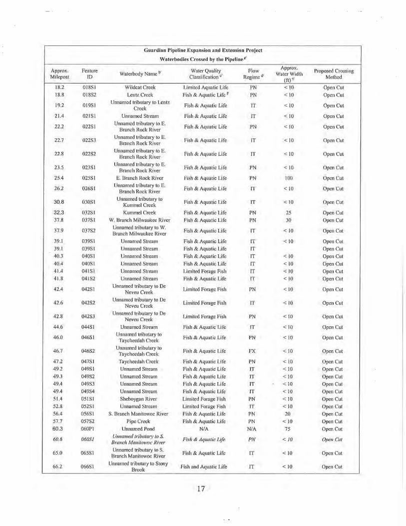
Guardian Pipeline Expansion and Extension Project
Waterbodies Crossed by the Pipeline•'
Approx. Feature Water Quality Flow Approx.
Proposed Crossing Waterbody Name !>' Water Width
Milepost ID Classification >1 Regime"' (ft),; Method
18.2 018S1 Wildcat Creek Limited Aquatic Life PN < 10 Open Cut
18.8 018S2 Lentz Creek Fish & Aquatic Life P PN <10 Open Cut
19.2 019S1 Unnamed tributary to Lentz
Fish & Aquatic Life IT < 10 Open Cut Creek
21.4 021SI Unnamed Stream Fish & Aquatic Life IT <10 Open Cut
22.2 022Sl Unnamed h·ibutary to E.
Fish & Aquatic Life PN < 10 Open Cut Branch Rock River
22.7 022S3 Unnamed tributary to E.
Fish & Aquatic Life IT < 10 Open Cut Branch Rock River
22.8 022S2 Unnamed tributary to E.
Fish & Aquatic Life IT < 10 Open Cut Branch Rock River
23.5 023SI Unnamed tributary to E.
Fish & Aquatic Life PN <10 Open Cut Branch Rock River
25.4 025S1 E. Branch Rock River Fish & Aquatic Life PN 100 Open Cut
26.2 026S1 Unnamed hibutary to E.
Fish & Aquatic Life IT <10 Open Cut Branch Rock River
30.8 030Sl Unnamed tributary to
Fish & Aquatic Life IT <10 Open Cut Kummel Creek
32.3 032SI Kummel Creek Fish & Aquatic Life PN 25 Open Cut
37.8 037S1 W. Branch Milwaukee River Fish & Aquatic Life PN 30 Open Cut
37.9 037S2 Unnamed tributary to W .
Fish & Aquatic Life IT <10 Open Cut Branch Milwaukee River
39.1 039S1 Unnamed Stream Fish & Aquatic Life IT < 10 Open Cut
39.1 039S1 Unnamed Stream Fish & Aquatic Life IT Open Cut
40.3 040S1 Unnamed Stream Fish & Aquatic Life IT <10 Open Cut
40.4 040S1 Unnamed Stream Fish & Aquatic Life IT < 10 Open Cut
41.4 041SI Unnamed Stream Limited Forage Fish IT < 10 Open Cut
41.8 041S2 Unnamed Sh·eam Fish & Aquatic Life IT <10 Open Cut
42.4 042Sl Unnamed tributary to De
Limited Forage Fish PN <10 Open Cut Neveu Creek
42.6 042S2 Unnamed tributary to De
Limited Forage Fish IT <10 Open Cut Neveu Creek
42.8 042S3 Unnamed tributary to De
Limited Forage Fish PN <10 Open Cut Neveu Creek
44.6 044S1 Unnamed Stream Fish & Aquatic Life IT <10 Open Cut
46.0 046S1 Unnamed tributary to
Fish & Aquatic Life PN < 10 Open Cut Taycheedah Creek
46.7 046S2 Unnamed hibutary to
Fish & Aquatic Life FX <10 Open Cut Taycheedah Creek
47.2 047S1 Taycheedah Creek Fish & Aquatic Life PN <10 Open Cut
49.2 049Sl Unnamed Stream Fish & Aquatic Life IT <10 Open Cut
49.3 049S2 Unnamed Sh·eam Fish & Aquatic Life IT < 10 Open Cut
49.4 049S3 Unnamed Stream Fish & Aquatic Life IT < 10 Open Cut
49.4 049S4 Unnamed Stream Fish & Aquatic Life IT <10 Open Cut
51.4 051S1 Sheboygan River Limi ted Forage Fish PN < 10 Open Cut
52.8 052SI Unnamed Stream Limited Forage Fish IT <10 Open Cut
56.4 056S1 S. Branch Manitowoc River Fish & Aquatic Life PN 20 Open Cut
57.7 057S2 Pipe Creek Fish & Aquatic Life PN < 10 Open Cut
60.3 060P1 Unnamed Pond NIA NIA 75 Open Cut
60.6 060SJ Unnamed triblllmy to S.
Fish & Aquatic Life PN < 10 Open Cut Branch Manitowoc River
65.0 065S1 Unnamed h·ibutary to S.
Fish & Aquatic Life IT <10 Open Cut Branch Manitowoc River
66.2 066S1 Unnamed tributary to Stony
Fish and Aquatic Life IT <10 Open Cut Brook
17

Guardian Pipeline Expansion and Extension Project
Waterbodies Crossed by the Pipeline>'
Approx. Feature Water Quality Flow Approx.
Proposed Crossing Milepost ID
Waterbody Name!>' Classification<' Regime<!'
Water Width Method (ft) <'
66.8 066S2 Stony Brook Fish and Aquatic Life PN 20 Open Cut
71.0 071Sl Killsnake River Fish & Aquatic Life PN 20 Open Cut
72.1 072SI Unnamed tributary to
Fish & Aquatic Life IT <10 Open Cut Killsnake River
72.8 072Sl Unnamed tributary to
Fish & Aquatic Life IT < 10 Open Cut Killsnake River
73.1 073S1 Unnamed Stream Fish & Aquatic Life IT < 10 Open Cut
73.4 073S2 Unnamed Stream Fish & Aquatic Life IT <10 Open Cut
73.9 073S3 Unnamed Stream Fish & Aquatic Life IT <10 Open Cut
74.3 074S1 Unnamed Stream Fish & Aquatic Life IT < 10 Open Cut
74.7 074S2 Unnamed Stream Fish & Aquatic Life IT <10 Open Cut
74.8 074S3 Unnamed Stream Fish & Aquatic Life IT < 10 Open Cut
75.4 075S1 Unnamed tributmy toN.
Fish & Aquatic Life IT < 10 Open Cut Branch Manitowoc River
76.2 075S1 Unnamed tributmy toN.
Limited Forage Fish IT < 10 Open Cut Branch Manitowoc River
76.8 076S2 Unnamed tributm)' toN.
Limited Forage Fish IT < 10 Open Clll Branch Manitowoc River
77.6 077S1 Unnamed tributary toN.
Limited Forage Fish IT < 10 Open Cut Branch Manitowoc River
77.9 077S2 Unnamed tributary toN.
Limited Forage Fish IT < 10 Open Cut Branch Manitowoc River
78.9 078Sl Unnamed tributary toN.
Limited Forage Fish IT < 10 Open Cut Branch Manitowoc River
78.9 078S2 Unnamed tributary toN.
Limited Forage Fish IT <10 Open Cut Branch Manitowoc River
79.8 079S1 Kankapot Creek Fish & Aquatic Life PN <10 Open Cut
80.6 080S3 Unnamed h·ibutaJy to Plum
Fish & Aquatic Life IT < 10 Open Cut Creek
80.9 080S1 Unnamed tributm)' to Plum
Fish & Aquatic Life IT < 10 Open Cut Creek
83.8 083S2 Unnamed tributmy to Plum
Fish & Aquatic Life IT < 10 Open Cut Creek
85.1 085Sl Unnamed h·ibutary to Plum
Fish & Aquatic Life IT < 10 Open Cut Creek
85.4 085S2 Plum Creek Fish & Aquatic Life PN <10 Open Cut
87.3 087S1 Unnamed tributary to East
Fish & Aquatic Life IT <10 Open Cut River
87.4 087S2 Unnamed tributary to East
Fish & Aquatic Life IT < 10 Open Cut River
88.5 088SI Unnamed tributary to East
Fish & Aquatic Life IT <10 Open Cut River
89.1 089S1 Unnamed tributary to East
Fish & Aquatic Life IT <10 Open Cut River
90.6 090S1 Unnamed tributary to Fox
Fish & Aquatic Life IT <10 Open Cut Ril•er
90.9 090S2 Fox River Fish & Aquatic Life PN 500 HDD
91.1 091S1 Apple Creek Fish & Aquatic Life PN 50 HDDgJ
91.7 091S2 Unnamed tributary to Fox
Fish & Aquatic Life IT <10 Open Cut Ril•er
93.1 093S1 Unnamed tributary to
Fish & Aquatic Life IT <10 Open Cut Ashwaubenon Creek
94.2 094S1 Ashwaubenon Creek Fish & Aquatic Life IT <10 Open Cut
94.6 094S2 Unnamed tributary to
Fish & Aquatic Life IT <10 Open Cut Ashwaubenon Creek
18

Guardian Pipeline Expansion and Extension Project
Waterbodies Crossed by the Pipeline¥
Approx. Feature Water Quality Flow Approx.
Proposed Crossing Milepost ID
Waterbody Name 1!1 Classification <1 Regime!!'
Water Width Method (ft) <1
95.4 095Sl South Branch Ashwaubenon
Fish & Aquatic Life IT <10 Open Cut Creek
99.6 099Sl N. Branch Ashwaubenon
Fish & Aquatic Life IT < 10 Open Cut Creek
100.2 JOOSJ Unnamed tributmy to
Fish & Aquatic Life IT < 10 Open Cut Dutchman Creek
100.5 JOOS2 Unnamed tributm)' to
Fish & Aquatic Life IT < IO Open Cut Dutchman Creek
100.6 JOOS3 Unnamed tributm)' to
Fish & Aquatic Life IT < 10 Open Cut Dutchman Creek
102.0 102S1 Duck Creek Fish & Aquatic Life PN 35 Open Cut
102.4 102S2 Unnamed tributm)' to Duck
Fish & Aquatic Life IT < 10 Open Cut Creek
102.6 102S3 Unnamed tributm)> to Duck
Fish & Aquatic Life IT < 10 Open Cut Creek
102.9 102S4 Unnamed tributmJ> to Duck
Fish & Aquatic Life IT < 10 Open Cut Creek
103.7 103SJ Unnamed tributmy to Duck
Fish & Aquatic Life IT < 10 Open C111 Creek
104.2 104Sl Unnamed tributary to Duck
Fish & Aquatic Life IT <10 Open Cut Creek
104.3 104S2 Unnamed tributary to Duck
Fish & Aquatic Life IT <10 Open Cut Creek
105.2 105S1 Unnamed tributmy to Duck
Fish & Aquatic Life IT < 10 Open Cut Creek
105.3 105S2 Unnamed tributm)' to Duck
Fish & Aquatic Life IT < 10 Open Cut Creek
106.1 106SJ Unnamed tributm)' to Duck
Fish & Aquatic Life IT < 10 Open Cut Creek
112.9 113S1 Unnamed Stream Fish & Aquatic Life IT <10 Open Cut
113.0 113SJ Unnamed Stream Fish & Aquatic Life IT < 10 Open Cut
114.9 114SJ Unnamed tributmy to S.
Fish & Aquatic Life IT < 10 Open Cut Branch Suamico River
117.0 117Sl S. Branch Suamico River Fish & Aquatic Life IT < 10 Open Cut
117.2 117S2 Unnamed tributm)' to S.
Fish & Aquatic Life IT < 10 Open Clll Branch Suamico River
20-Inch Southwest Green Bay Branch Line
0.3 SWOOS1 Unnamed Stream Fish & Aquatic Life IT <10 Open Cut
19

Approx. Milepost
Feature ID
Guardian Pipeline Expansion and Extension Project
Waterbodies Crossed by the Pipeline"
Waterbody Name"' Water Quality
Classification'' Flow
Regime~'
Approx. Water Width
(ft) <I
Proposed Crossing Method
nf Based on USGS Mapping, the Wisconsin DNR 24k Hydrography layer (http://maps.dnr.state. wi.US), and Guardian's field
surveys to date . Italicized rows indicate areas where field investigations have not been completed due to a lack of access.
b.l Waterbody names are based on Wisconsin DNR 24k Hydrography layer naming conventions.
r;/ Fish & Aquatic Life - The Default use designation that applies to surface waters when the WDNR has not completed a formal site visit of a stream segment. TI1e default use designation is used to make decisions for issuing discharge permits unless an alternate use designation is specified in either Ch. NR 102 or Ch. NR I 04 of the Wisconsin Administrative Code. The default use designation is equivalent to a Warm Water Sport Fish Community classification.
Wann Water Sport Fish Community- Surface waters assigned this use designation support a diverse community of game fish, forage fish, and other aquatic life that are not tolerant to organic pollution . Wastewater discharges to these waterways may not lower the dissolved oxygen content in the water to less than 5 mg/L.
Limited Forage Fish Community - Surface waters assigned this use designation support a community of forage fish and other non-fish aquatic life that are moderately tolerant to organic pollution. Wastewater discharges to these waterways may not lower the dissolved oxygen content in the water to less than 3 mg/L.
Limited Aquatic Life Community - Surface waters assigned this use designation support a community of a small number of forage fish species and other non-fish aquatic life species that are very tolerant to organic pollution. Wastewater discharges to these waterways may not lower the dissolved oxygen content in the water to less than 1 mg/L.
Q1 Based on Wisconsin DNR 24k Hydrography layer designations and aerial photography interpretation and/or site visit for unmapped streams:
IT= Intermittent
PN =Perennial
FX = Fluctuating
rj Estimated from 2005 and 2006 aerial photography.
f/ Proposed as Limited Aquatic Life.
gj Apple Creek will be crossed as part of the proposed Fox River HDD.
Potential Impacts to Surface Waters and Aquatic Life
Impacts to surface waters would primarily be limited to the period of construction and restoration, and depend on the season, duration, and method of pipeline installation. Construction and operation of the proposed pipelines can cause impacts on fish and other aquatic resources from sedimentation and turbidity, destruction of stream habitat, and introduction of water pollutants. After installation, waterbody beds and banks would be restored, as near as practicable, to original condition. Disturbed soils adjacent to the waterbodies would be stabilized and reseeded with approved seed mixes.
Installing a pipeline across a stream or river can temporarily displace stream bed sediments and increase erosion of soils adjacent to the waterbody. The magnitude and duration of these effects depends on the soils and topography of the site, and the permitted crossing method. Construction could also change the stream bottom profile, resulting in increased siltation or erosion at the site or further downstream. DNR waterway permit review staff members (permit staff) have indicated that the DNR permits will require restoration of the streambed contours to preconstruction conditions.
Increased sedimentation and turbidity from the proposed construction have the greatest potential to adversely affect fisheries resources. Trout spawning areas are especially susceptible to
20

increased sedimentation by fine particles. Increase of fines composition less than 3 millimeters in size can reduce survival of eggs and emerging fry and degrade spawning habitats.
Some in-stream and shoreline cover may be altered or removed at the proposed stream crossings. Stream bank vegetation, in-stream logs, rocks, and undercut banks provide important cover for fish. Fish that normally reside in or pass through while foraging in these areas would be displaced during construction.
Pipeline construction activities could destroy fish spawning habitats. Trout spawning areas, in particular, require specific substrates which may occur within the pipeline crossing areas. Successful spawning may also require groundwater upwelling that could be disrupted temporarily or permanently at the stream pipeline crossing locations.
Spring, summer, or fall spawning runs of some fish, including trout, could be interrupted by pipeline construction. This would occur if construction activities prevent or deter fish from passing through the construction zone. Most runs in small streams occur over several days or weeks, consequently, in the worst case, migration might be briefly interrupted, or sites where eggs were deposited might be destroyed. Upon hatching, larvae of some species of fish drift downstream to disperse, which could be interrupted when pipeline construction alters water flow.
Spills of fuel or other substances from construction equipment into streams could be toxic to fish, depending on the type, quantity, and concentration of the spill. Further discussion of spills and the proposed plans to reduce spill potential can be found in a separate section of this EA, and in detail in Appendix F ofthe FERC EIS.
The linear nature of pipeline construction can make it a pathway for spreading invasive species. Purple loosestrife (Lythrum salicaria), reed canary grass (Phalaris arundinacea), Eurasian water milfoil (Myriophyllum spicatum), and zebra mussels (Dreissena polymorpha ), among others, may be spread by construction activities. Further discussion of invasive species can be found in a separate section of this EA.
Construction Techniques for Crossing Waterways
Overall Process
There are a variety of methods to install a pipeline across a waterway. In their permit applications, the applicants have identified a preferred method for crossing each stream, selected based on the physical and engineering characteristics of the crossing, the general environmental sensitivity of the water resource, and input from regulatory agencies. The DNR Chapter 30 permit will dictate the construction method that is authorized at each waterway.
To allow the passage of construction equipment and materials along the ROW, temporary bridges will be installed across waterways. Temporary bridges will consist of either clean rock placed over flume pipes; clear span prefabricated construction mats; flatbed railroad cars; or flexi-float bridges. Equipment crossings of waterways will be restricted to bridges that are authorized by the DNR Chapter 30 permit.
21

The proposed mainline and lateral projects include the use of five distinct constmction methods for crossing waterways:
• open trench • dam and pump • flume • horizontal direction drill, and • jack and bore.
These crossing methods have common procedures and unique components, which are discussed below. These descriptions are based on the proposed constmction methods in the project applications. The general constmction practices proposed by Guardian, WG, WE and WPS are similar.
Standard crossing methods normally require a gradual and unifonn approach to the waterbody to prepare a suitable work area for constmction equipment and place the pipeline. This usually requires removing bank vegetation and grading the banks away from the waterbody. This process could temporarily increase the potential for soil erosion until constmction is complete and the right of way is stabilized and reseeded.
Erosion control measures would be installed before constmction. Temporary erosion controls nonnally include storing all excavated spoil in containment areas that prevent the spoil from entering the stream, and installation of silt fence and/or straw bales to prevent mnoff from upland areas from entering the stream. Additional temporary workspaces on each side of the waterbody are generally required for staging the crossing. These are typically 50 feet wide by 150 feet long. There will be an undisturbed buffer between the additional temporary workspace and the waterway.
Following installation of the pipeline across the waterway, the ROW on either bank would be regraded to its approximate preconstmction contours. Disturbed stream and river banks would be stabilized with biodegradable geotextile fabric, jute thatching, or bonded fiber blankets. Disturbed soils would be fertilized, seeded, and mulch would be applied as needed. Temporary bridges would be removed after seeding and mulching are complete. Temporary erosion control measures would be removed after pe1manent erosion control measures are installed and vegetation is re-established. ·
Open Trench Crossing Method
For an open trench crossing, a trench would be excavated through the stream using draglines or backhoes operating from one or both banks. The potential impacts to a waterway and its biota from open trench constmction are quite different if the trenching is done when the waterway has flowing water rather than when the stream is dry.
DNR permit reviewers have indicated that open trench installation of the proposed pipelines would be limited to intermittent waterways with no flowing water at the time of construction. If
22

there is flowing water, one of the other crossing methods would have to be used. This environmental assessment assumes that the open trench construction would be allowed only during times of no stream flow.
Restricting open trenching to times of no flow eliminates the direct construction impacts to the stream's water column, avoiding the associated sedimentation of habitat for fish and aquatic invertebrates, water quality degradation, and reduced light for aquatic plants and algae. No longterm impacts to the stream would be expected if the contours of the streambed are restored to their pre-construction condition, which DNR permit staff has indicated would be required by the Chapter 30 permit.
Dam and Pump Crossing Method
The dam and pump stream crossing method is slower and more expensive than the open trench method, however it generally reduces the water quality impacts caused by open trenching. It is also preferred for small streams that are sensitive to sediment loading. This method involves damming the stream on either side of the construction area before trench excavation, using sand bags or other methods that greatly minimize the addition of sediment to the stream. Before the dams are installed, one or more water pumps would be placed on the upstream side of the proposed trench so water can be pumped around to the downstream side of the construction area.
The placement and removal of the pumps and damming material would cause minor sediment suspension. Where the pump hose discharges downstream of the crossing, energy dissipation devices would be used as necessary to prevent scouring of the stream bed. Trenching, installation of the pipeline, and restoration of the banks and ROW would be completed in the same manner as described for the open trench method. However, because the stream flow is pumped around the construction area instead of through it, only minimal sediments would be displaced by construction. The use of the bypass pumping to redirect stream water flow around the construction area would temporarily block movements of fish and other aquatic organisms through the area.
Flume Crossing Method
The flume method is suitable for small to inte1mediate streams with straight channels at the crossing area, and that are sensitive to sediment loading. Flumes made of large pipe sections would be aligned in the stream parallel to the water flow. The stream would then be dammed with a diversion bulkhead to direct stream flow through the flumes. A similar bulkhead would be installed at the downstream end of the flumes to prevent backwash from entering the construction area. Energy dissipation devices would be installed as needed to prevent scouring at the discharge location. A trench would then be excavated underneath the flumes in the exposed section of stream bed. A section of pipeline long enough to span the stream would be welded together and pulled beneath the flume. The flumes would be removed after the installation of the pipeline. Backfilling and bank restoration would be completed as described for the open trench method. Fluming, like the dam and pump method, isolates stream flow from the construction area and allows installation of the pipeline without significant displacement of
23

sediments. The use of the flume to redirect stream water flow through the construction area would also tempormily prevent movement of fish and other aquatic organisms.
Horizontal Directional Drill Crossing Method
Directional drilling minimizes the environmental effects of pipeline construction on a waterbody or waterway by going beneath its bed and avoiding direct disturbance of the bed and banks. This technique is especially useful for wide crossings, where navigation traffic is high, areas where bottom sediments are contaminated, or where there are sensitive habitats or cultural resources near the banks. The HDD method involves using a special drill rig to drill a gently curved borehole below the surface of the ground and the bed of the waterway. After it exits onthe opposite side of the stream, the drilling machine pulls a long, pre-welded pipeline section back through the drilled hole.
Temporary workspaces would be cleared for d1illing equipment, measuring approximately 250 feet long by 50 feet wide on the entry side of the crossing. A slant drill unit would be placed on one bank and a small-diameter pilot hole would be dlilled under the stream. After the pilot hole has been completed, it would be enlarged to accept the pipeline by pulling a barrel reamer back and forth through the bore hole. D1illing mud would be continuously pumped into the hole to remove cuttings and maintain the integrity of the enlarged hole. After the hole has been reamed, a prefabricated pipeline section long enough for the crossing would be pulled through the hole by the drilling rig.
An HDD crossing avoids most of the potential impacts that are a concern with pipeline crossings of waterways, as the pipeline is installed beneath the bed of the waterway. There is no disturbance or change to either the bed or water column. Many of the potential concerns desclibed for other methods of crossing waterways, including sedimentation and turbidity, habitat alteration, disrupting breeding and movement patterns, and the introduction of pollutants into the water column, do not occur when the HDD method is properly used.
HDD construction uses a d1ill "mud" under pressure to lubricate the drill pipe, remove drill cuttings and maintain the integtity of the drill hole. The drilling mud is usually a water-based slurry of bentonite clay which may have an emulsifier added. Dlilling mud and cuttings would also require disposal. Pressmized drilling mud may leak to the surface, or "frac-out." Such failures are not easily predicted; however, the impacts from failure can be reduced by monitoring mud pressure and drilling head location, inspecting the surface during the drill process, and by increasing the depth of the dlill path below the bed of the river. In most cases the volume of sediment resulting from seepage of d1illing mud would be far less than the amount produced by a conventional open-cut crossing.
Dming the crossing, drilling mud is stored away from the river in an earthen berm containment structure or fabricated containment tan1cs sized to accommodate the volume of mud necessary for the drill. Following completion of directional drilling, mud is disposed of in accordance with applicable state and local requirements. Where landowner permission is available, mud is typically land-spread in upland, agricultural fields. Iflandowner permission is not available or
24

land-spreading is not appropriate for some other reason, drilling mud would be disposed of in a landfill or other authorized disposal site.
If an unanticipated frac-out were to occur in an upland location, the drilling mud would be contained to the extent possible with standard erosion control measures such as silt fences and/or hay bales, then disposed of properly by removing and spreading over an upland area or hauled off-site to an approved location.
A frac-out can occur in the bed of a waterbody or an adjacent wetland. If an in-stream frac-out occuned, the drilling would stop to develop an appropriate response. If proceeding with the HDD crossing would cause significant adverse impacts to waterbodies and fisheries resources, the HDD would stop, and an alternative crossing method would be used. For a wetland frac-out, the sluny at the surface would be isolated using silt fence and/or hay bales, then removed by vacuum tluck, machinery, or by hand, and disposed of in an acceptable upland location.
Jack and Bore Crossing Method
This method is used primarily to install pipe under a surface, or shallow obstructions such as roads, railroads and other existing utilities. In some instances it may be used to install a pipeline under waterways. This method is also called auger boring or pipe jacking.
With this method, two construction pits are dug, a jacking pit and a receiving pit. The pits are typically about 15 feet wide and 35 feet long. A rotating boring machine is used to create a hole, starting from the jacking pit and ending in the receiving pit. A casing pipe, larger in diameter than the gas pipe, is pushed into the hole following the boring machine. After the casing pipe has been installed between the jacking and receiving pits, the gas pipe is slid into the casing pipe. The void area between the casing pipe and the bored soils is filled with grout and the area between the casing pipe and the gas pipe is filled with pea gravel or sand.
There is little potential for a frac-out condition occurring during jack and bore installation, unlike that for a HDD installation, because the bentonite drilling sluny is not pressurized. The unpressurized drilling sluny would not have a force mechanism to push it far enough out of the drill hole to result in a frac-out release.
The use of this method to install a pipeline avoids most of the potential impacts that are a concern with pipeline crossings of waterways that place the pipe beneath the bed of the waterway. There is no disturbance or change to either the waterway's bed or water column. Many of the potential impact of some other methods of crossing waterways, including sedimentation and turbidity, habitat alteration, disrupting breeding and movement patterns, and the introduction of pollutants into the water column, do not occur when this method is used.
25

Operation and Maintenance Related Impacts
Other than inspections from vehicles and routine removal ofbmsh and trees, there should be little long-te1m disturbance of the con1dor, and associated long-term effects on water quality due to operating and maintaining the proposed pipeline pipelines. Catastrophic effects due to pipeline failures during operations and maintenance are possible, but unlikely.
Waterway Summary Most waterways that would be affected by the proposed pipeline are intermittent, with no flowing water during portions of the year. DNR pe1mit reviewers have indicated that open cut trench crossings of these waterways would only be allowed at times of no flow. With this restriction, open cut trenching would not alter the streams' water quality or have any direct effect on aquatic life. With simple restoration efforts, using this method would also not substantially change either streambed configuration or flow characteristics.
Each of the perennial waterways that would be crossed are identified and discussed in the project-specific chapters of this EA. The potential environmental consequences to the waterways that would be crossed using HDD or jack and bore pipeline constmction method would be minimal, because those pipeline installation methods do not directly disturb the bed or water column of the waterway. The potential impacts to the perennial waterways crossed using a dam and pump or flume method, are also expected to be minor, with impacts primarily of temporarily inhibiting movements of fish and other aquatic organisms through the constmction zone.
Wetlands
Wetlands along the routes of the proposed pipeline projects are of four major community types: wet meadow (including sedge meadows, wet prairies and seasonally flooded basins), emergent, scrub/shrub, and forested wetlands. Emergent wetlands include shallow marsh and deep marsh. Scrub-shmb wetlands include shrub-carr and previously cleared wetlands dominated with shrub vegetation. Forested wetlands include hardwood swamp and floodplain forest. For the purposes of this assessment, the wet meadow and emergent wetlands are grouped together. The wetland community types follow accepted terminology for the Wisconsin region and are based on Eggers and Reed (1997/.
Wet and sedge meadow, and wet prairie communities, are characterized by a predominance of herbaceous vegetation with a limited amount of woody vegetation. These communities grow on saturated soils but can be dry for much of the growing season. Ponded water is typically present only after floods or snowmelt events. Reed canary grass (Phalaris arundinacea) typically dominates wet meadow communities in the project area, often forming dense monotypic stands.
3 Eggers, Steve D., and Donald M. Reed. 1997. Wetland plants and conununities of Minnesota and Wisconsin. U.S. Army Corps of Engineers, St. Paul District. 263pp.
26

Seasonally flooded basins are shallow depressions that typically hold water for a few to several weeks each year, but are usually dry for much ofthe growing season and often are farmed.
Emergent wetlands are shallow open water plant communities with deeper water than the wet meadow communities. Submergent, floating and floating-leaved aquatic vegetation characterize this community type. Shallow marshes have soils that are saturated to inundated by standing water up to a depth of about six inches throughout most of the growing season. Emergent vegetation such as cattails (Typha sp.), bulrushes (Scirpus sp.), arrowheads (Sagittaria sp.), and lake sedges (Carex lacustris) are common in this community. These shallow marshes often grade into sedge or wet meadows where the soil is drier.
Scrub/shrub wetlands are dominated by relatively short and narrow-stemmed woody plants. These communities grow on both organic and mineral soils with hydrology ranging from seasonal saturation to inundation for most of the growing season. Shrub-carr communities are dominated by willow (Salix sp.) and/or dogwood (Cornus sp.) shrubs with an understory typically comprised of various forbs, grasses, sedges, and ferns, and are found throughout Wisconsin.
Forested wetlands include hardwood swamps and floodplain forests . Hardwood swamps differ from floodplain forests due primarily to hydrologic setting and degree of soil saturationfloodplain forests occur in riverine systems on alluvial soils while hardwood/conifer swamps are typically associated with ancient lake basins and riverine oxbows. For the purposes ofthis EA, these communities were combined due to their relatively similar structural and vegetative composition.
Hardwood swamps are forested wetlands dominated by deciduous hardwood trees with a stratified understory of various shrubs, saplings, grasses, sedges, and forbs. This community is underlain by soils that are saturated for much of the growing season and may be inundated by as much as 12 inches of water. Hardwood swamps are found throughout Wisconsin. Similar to hardwood swamps, floodplain forests are also forested wetlands dominated by deciduous hardwood trees. However, this community is associated with riverine systems and is inundated during flood events, but is somewhat well drained during other portions of the year. These flooding events can limit the density of shrubs and herbaceous species in this community.
The following table shows the number of wetland crossings for each project. The total number of wetlands crossed is 203.
27
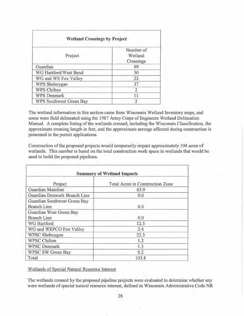
Wetland Crossings by Project
Number of Project Wetland
Crossings Guardian 99 WG Hartford/West Bend 30 WG and WE Fox Valley 22 WPS Sheboygan 37 WPS Chilton 2 WPS Denmark 11 WPS Southwest Green Bay 2
The wetland infonnation in this section came from Wisconsin Wetland Inventory maps, and some were field delineated using the 1987 Almy Corps of Engineers Wetland Delineation Manual. A complete listing of the wetlands crossed, including the Wisconsin Classification, the approximate crossing length in feet, and the approximate acreage affected during construction is presented in the permit applications.
Construction of the proposed projects would temporarily impact approximately 104 acres of wetlands. This number is based on the total construction work space in wetlands that would be used to build the proposed pipelines.
Summary of Wetland Impacts
Project Total Acres in Construction Zone Guardian Mainline 63.9 Guardian Denmark Branch Line 0.0 Guardian Southwest Green Bay Branch Line 0.0 Guardian West Green Bay Branch Line 0.0 WG Hartford 12.5 WG and WEPCO Fox Valley 2.4 WPSC Sheboygan 22.3 WPSC Chilton 1.2 WPSC Demnark 1.3 WPSC SW Green Bay 0.2 Total 103.8
Wetlands of Special Natural Resource Interest
The wetlands crossed by the proposed pipeline projects were evaluated to determine whether any were wetlands of special natural resource interest, defined in Wisconsin Administrative Code NR
28

103.04 to include both those wetlands within the boundary of designated areas of special natural resource interest (ASNRI), and those wetlands which are in proximity to or have a direct hydrologic connection to such designated areas. ASNRI include:
• Cold water community as defined in§ NR 102.04(3)(a), Wisconsin Administrative Code, including trout streams, their tributaries, and trout lakes.
• Lakes Michigan and Superior and the Mississippi River. • State- or federally-designated Wild and Scenic River. • State-designated rivetway and scenic urban waterway. • Environmentally sensitive area or environmental corridor identified in an area-wide water
quality management plan, special area management plan, special wetland inventory study, or an advanced delineation and identification study.
• Calcareous fen. • State park, forest, trail, or recreation area. • State and federal fish and wildlife refuges and fish and wildlife management area. • State- or federally-designated wilderness area. • State-designated or dedicated natural area (SNA). • Wild rice water listed in§ NR 19.09, Wisconsin Administrative Code. • Surface water identified as outstanding or exceptional resource water in Wisconsin
Administrative Code ch. NR 102.
Habitats used by state or federally endangered or threatened species are also considered ASNRI. In addition, the Brown County Planning Department classifies area of steep slopes (greater than 12 percent) adjacent to wetlands as being environmentally sensitive, which classifies them as ASNRI. Further identification of the wetlands of special natural resource interest is provided in the project specific chapters of this EA.
Pipeline Construction Impacts on Wetlands
The temporary removal of wetland vegetation is a primary impact of pipeline construction and right-of-way maintenance activities. Construction also would temporarily diminish the recreational and aesthetic value of the wetlands crossed. These effects would be greatest during and immediately following construction. In wet meadow/emergent wetlands, the impact of construction would be relatively brief, since herbaceous vegetation regenerates within one or two seasons. In forested and shrub-dominated wetlands, the impact would last longer due to the longer recovery period of these vegetation types. Long term vegetation management over the pipeline to allow access and inspection would prevent regeneration of tree and shrub cover. Clearing of wetland vegetation would also temporarily, or in some cases, permanently, remove or alter wetland wildlife habitat.
Trench excavation is a major disturbance of a wetland, but construction activities would also impact wetlands outside of the trench area. Compaction and rutting of wetland soils could result from the temporary stockpiling of soil and the movement of heavy machinery. Surface drainage patterns and hydrology could be temporarily altered, and there would be increased potential for the trench to act as a drainage channel. Trench breakers would be placed in the trench to prevent the flow of groundwater in the backfilled trench. Increased siltation in adjacent wetland areas
29

may result from trenching activities. Disturbance of wetlands also could temporarily affect the wetland's capacity to reduce/moderate erosion and floods.
Constmction through wetlands would comply, at a minimum, with conditions set in the Section 404 permit, and the state's 401 water quality certification, following Wisconsin Administrative Codes NR299 and NR103. The evaluation of potential impacts from crossing wetlands is based on the DNR waterway and wetland pe1mit requiring use of appropriate erosion control practices along with the restoration of the wetland contours to preconstmction conditions.
Guardian, WG, WE and WPS have all described constmction measures to be used for constmction in wetland areas. The PERC Draft EIS outlines the wetland constmction techniques in section 4.4.1.3, beginning on page 4-37. In general, the proposed constmction methods are similar. The following discussion summarizes the major components of these proposed constmction methods.
Staging areas and extra workspace would be needed on both sides of some of the larger wetlands. These areas would be located at least 50 feet away from the wetland boundaries, where topographic conditions permit, and would be limited to the minimum area needed for assembling the pipeline. Storage of hazardous materials, chemicals, fuels, and lubricating oils would generally be prohibited within 100 feet of wetland boundaries.
Temporary erosion control devices would be installed at the base of cleared slopes leading to wetlands. If there is no slope, erosion control devices would be installed as necessary to prevent exposed soils from flowing off the ROW into the wetland or to prevent sediment from flowing from adjacent uplands into the wetlands.
During clearing, woody wetland vegetation would be cut at ground level and removed from the wetland, leaving the root systems intact. In most areas, removal of stumps and roots would be limited to the area directly over the trench. Stumps from areas outside of the trench line would be removed, as necessary, to provide a safe work surface.
To facilitate revegetation of wetlands, up to one foot of topsoil would be stripped over the trench, except in areas where standing water or saturated soils make it impracticable, where no topsoil layer is evident, or where the topsoil layer exceeds the depth of the trench.
The use of either low ground-pressure equipment or standard constmction equipment operating from timber pads would reduce disturbance of wetlands with saturated soils or standing water. Imported rock, stumps, bmsh, or offsite soil would not be used as temporary or permanent fill in wetlands. Following constmction, materials used in wetlands to provide stability for equipment access would be removed.
If the standard crossing method is not practical because of saturation or standing water, either a push/pull method or winter constmction might be used. Use of the push/pull method is generally limited to large wetlands with standing water and/or saturated soils that have adequate access for pipeline assembly and equipment operation on either side of the wetland. If this method is used, a long section of pipeline would be assembled on an upland area of the ROW adjacent to the
30

wetland. Usually this requires use of extra temporary workspace adjacent to the ROW. The trench would be dug by a backhoe supported on timber mats. The prefabricated section of pipeline would then be floated across the wetland. When the pipeline is in position, the floats would be removed and the pipeline would sink into position. The trench would then be backfilled and the miginal contours would be restored by a backhoe working from construction mats.
Under frozen conditions, the pipe would be installed in wetlands similar to conventional upland construction. Because equipment is supported by frozen soil and ice, temporary mats would not be required. The success of winter construction depends on prolonged periods of subfreezing temperatures, which produce sufficient frost depth. Because these conditions are not always predictable, the ability to use the winter construction method is generally not assured. Ice roads may also be used to decrease impacts. Ice roads are created by plowing the snow off of the wetland surface, and driving sequentially heavier pieces of equipment across the wetland surface to facilitate the penetration of the frost deeper in the ground; creating a stable working surface.
Following restoration of contours, wetlands would typically be seeded with annual ryegrass as a cover crop. Other measures such as replacement of the original surface soil, with its stock of roots and tubers can facilitate restoration. The wetland would either be seeded with an appropriate native wetland seed mix or allowed to revegetate naturally to preconstruction vegetative covers. No lime or fertilizer would be added to disturbed wetland areas, unless required in writing by the appropriate permitting agency. After a period of monitoring, wetlands that do not appear to be regenerating by this process may need to be seeded with an approved native seed mix.
Most of the wet meadow wetlands have, or are dominated by, reed canary grass, which is a very aggressive invasive plant. In wetlands that contain the grass, it is likely that, following construction, the ROW and workspace area would become dominated by the grass because of the disturbance and spreading of the plant rhizomes, which facilitate spread. A wetland free of reed canary grass should be protected from its introduction by construction mitigation techniques specified in the DNR water quality certifications.
Operation of the pipelines would not require alteration of wetlands other than periodic brush and tree control in the pipeline's permanent ROW. No permanent filling, dredging or other longterm wetland disturbance is anticipated.
Federal Wetland Compensatory Mitigation requirement
As part of its federal permit requirements, Guardian proposes to mitigate the expected wetland impacts in accordance with the U.S. Army Corps of Engineers requirements. Moreover, Guardian has proposed to compensate for all forested wetland impacts within the existing easement and temporary workspace corridor at a 0.5 to 1 ratio. Appropriate compensation would be determined by the Corps, in consultation with USEP A, FWS and DNR. Compensatory mitigation plans are pending at this time.
31

The U.S. Army Corps of Engineers is not requiring compensatory mitigation for wetland impacts associated with the laterals.
Invasive Species and Plant and Animal Diseases
Invasive plant species, are non-native, undesirable native, or introduced species that are able to exclude and/or out-compete desired native vegetation, thereby decreasing overall species diversity. Many of these species tluive on disturbed soils, so vegetation removal and soil disturbance during construction could create optimal conditions for their establishment. Invasive species are found throughout the proposed ROWs for the Guardian mainline and each lateral, however, the species, percent of cover, life cycle and habitat vary greatly.
The project applicants have noted the presence of invasive wetland plants in the plant species lists during wetland delineations. The presence and relative abundance of these plants has been recorded and would be used to assess the potential for spreading these invasive plants from wetlands containing a high abundance of invasive species to wetlands with low abundance or no invasive plant species.
Nuisance weeds such as purple loosestrife and its hybrids, and multiflora rose are regulated under Chapter 23.235 of the Wisconsin Statutes. This regulation prohibits the sale, distribution, or cultivation ofthese species. Noxious weed regulations found at Wisconsin Statute 66.0407 define noxious weeds as Canada thistle, leafy spurge, and field bindweed and any other weed a governing body of a municipality or county board declares to be noxious within its respective jurisdiction.
The comn1on invasive species that would likely be present along the route include(* indicates presence is identified in application):
Purple loosestrife (Lythrum salicaria) Giant reed grass (Phragmites australis) Common and glossy buckthorn (Rhamnus cathartica and frangula) Reed canary grass (Phalaris arundinacea)* Eurasian water milfoil (Myriophyllum spicatum) Narrow-leaved cattail and hybrid cattail (Typha angustifolia and Typha x glauca)* Autumn olive (Elaeagnus umbellata) Japanese knotweed (Polygonum cusp ida tum) Black locust (Robinia pseudoacacia) Honeysuckles (Lonicera maacldi, morrowii, tatarica) Spotted Knapweed ( Centaurea maculosa) Leafy spurge (Euphorbia esula) Wild parsnip (Pastinaca sativa) Japanese hedge parsley (Tori/is japonica) Garlic mustard (A/haria petiolata) Canada thistle ( Cirsium arvense)
32

Most of the wet meadows along the proposed pipeline routes are dominated by or contain reed canary grass. The likelihood it will remain dominant following constmction is high. The cattail and cattail hybrids are also widespread in the overall project area in wetlands with deeper water than those that are dominated by reed canary grass.
The Sheboygan River is the only waterway with a known population of Eurasian water milfoil, but WPS has proposed that the Sheboygan lateral cross this river with HDD, which would not require any constmction equipment to enter the river, significantly reducing any potential to spread the milfoil to other waters.
The linear nature of pipeline constmction can help the spread of invasive species. One way to reduce this is avoiding the population, thereby limiting the dispersal of seeds and plant matter. Also recommended is cleaning equipment after leaving an infested area and entering another area. Sequencing constmction such that the infested areas are done last would reduce the transportation of seeds and plant matter to uninfested areas. FERC's procedures (appendix E of the Draft EIS) require control of invasive plant species.
Invertebrates
Zebra mussels are becoming more widespread in the inland waters of Wisconsin and could be spread by constmction activities. Segments of the proposed pipeline projects may cross zebra mussel-infested waters. Watercress Creek is connected to Long Lake which has Zebra mussels. Willow Creek is connected to the Sheboygan River and Lake Michigan which has Zebra mussels . Special permit conditions may be required for in-water constmction and pipeline hydrostatic testing to prevent the spread of Zebra mussels.
Diseases
Oak wilt is a fatal tree disease that most often affects oak species in the red oak family. It is caused by a fungus, Ceratocystis fagacearum, which invades water-conducting vessels and induces the formation of balloon-like projections called tyloses which also plug the vessels. As water movement within the tree is slowed, the leaves wilt and drop off the tree. Removal or trimming of oak trees in spring, when the fungus produces spores, can enhance the spread of the disease. Oak wilt occurs in most eastern Wisconsin counties. Constmction of the proposed gas pipelines could contribute to the further spread of oak wilt if cutting, pmning, or damage to oaks occurs. The DNR has developed a set of practices designed to limit or reduce spread of oak wilt. DNR staff is recommending that the Guardian, WG, WE and WPS follow these practices.
33

Viral Hemonhagic Septicemia, known as VHS, is an infectious viral disease of fish that can cause fish to bleed to death. It was diagnosed for the first time in fish in the Great Lakes in 2005, and was confirmed as the cause of fish kills in Lake Huron, Lake St. Clair, Lake Erie, Lake Ontario and the St. Lawrence River in 2005 and 2006. In May, 2007 two drum, or sheepshead, from Little Lake Butte des Morts, Wisconsin tested positive for VHS. This virus is not a health threat to people who eat or handle infected fish, but it is a serious threat to fish.
Infected fish shed the virus into a lake or river through their urine and reproductive fluids. VHS virus can remain infective up to 14 days in water and the virus particles are absorbed into the gills of healthy fish and infect them. Healthy fish can also be infected when they eat an infected fish.
Infected fish and water can easily spread the virus if they are released into a new water body. Special permit conditions may be required for in-water construction and pipeline hydrostatic testing to prevent the spread of VHS.
Groundwater, Trench Dewatering, and Spills
The uppermost major aquifer in most of eastern Wisconsin is the sand and gravel aquifer, which consists of unconsolidated deposits of sand and gravel within the glacial drift that covers most of the state. Well yields within the sand and gravel aquifer generally range between 5 and 500 gallons per minute (gpm), but most are between 5 and 15 gpm. Well depths within the aquifer typically range from 20 to 200 feet, but most are less than 100 feet deep.
Sedimentary bedrock aquifers lie beneath the sand and gravel aquifer, starting with the Silurian age Niagara dolomite discussed previously. Deeper aquifers consist of Paleozoic-age sandstone and dolomite. These rock formations are able to produce enough water to be considered an aquifer. Well depths can range from 66 to 1100 feet with most wells around 230 feet deep.
Municipalities along the pipeline routes that obtain drinking water from groundwater typically use wells extending into the lower bedrock aquifer. Most residences that are not connected to municipal water supplies probably obtain drinking water from private wells, some of which may tap the shallow sand and gravel aquifer. Since residences are located near each of the pipeline project routes, it is likely private wells are near the proposed routes.
While construction of pipelines could affect groundwater resources, the potential impact is generally considered to be minor due to the limited depth to which pipeline construction trenches are excavated. The shallow sand and gravel aquifer could be locally impacted by changes in overland water flow and recharge caused by clearing and grading of the construction ROW. In forested areas, enhanced water infiltration provided by a well-vegetated cover would be temporarily lost until vegetation is successfully reestablished. Near-surface soil compaction caused by heavy construction vehicles could also reduce the soil's ability to absorb water. This minor impact would be temporary and would not be expected to significantly affect groundwater resources.
Blasting may be required to excavate the pipeline trench in limited areas where bedrock is exposed or within trench depth of the ground surface. Blasting near groundwater wells may cause temporary changes in water level and turbidity. These effects can be minimized by the
34
selection of proper blasting techniques, so that rock would only be fractured in the immediate area of the blast locations. Use ofblasting to excavate a pipeline trench would be subject to federal, state and local laws, permits and authorizations. These approvals would likely include measures that control energy release during blasting, along with imposing safeguards to protect nearby persons and propetiy. Specific locations where blasting might be necessary have not yet been identified. It is unlikely that groundwater quality and supply systems beyond the ROW would be affected by blasting.
Temporary dewatering of a pipeline trench may be required during construction when the accumulation of either groundwater or surface runoff restricts either visual inspection of the trench bottom before lowering in the pipe, or actual work in the trench. During trench dewatering, a hose is placed in the trench with the intake suspended above the bottom of the trench to avoid disturbing sediment. Water is then pumped from the trench and discharged to an upland area or dewatering structure. For well point dewatering, well points are driven into the ground adjacent to the construction area. Groundwater is pumped through the well points, temporarily lowering the local water table and enabling work to occur below the natural water table level.
As previously discussed, pipeline trenches will normally be approximately six feet deep, whereas most shallow residential wells range from 20 to 200 feet. At this depth, dewatering of surface runoff or ground water is not anticipated to cause a significant drawdown of nearby residential wells. Fmthermore, trench dewatering is typically short-term and used only as necessary during certain construction activities. Consequently, well impacts resulting from construction dewatering are unlikely.
The potential impacts on users of unconfined, shallow aquifers depend on the rate and duration of pumping and the distance of the dewatering operation from the well itself. While high capacity wells (greater than 70 gallons per minute) are subject to DNR regulation under Ch. NR 812, Wis. Admin. Code, it is unlikely that dewatering would require use of high capacity wells.
At any one location, trench dewatering typically only continues for a few days, keeping potential impacts very localized and temporary. Typically, the impact of dewatering activities is reduced by discharging all water into well-vegetated upland areas or properly constructed dewatering structures, which allow the water to infiltrate back into the ground and return to the aquifer. Discharge of trench dewatering waters is regulated by Wisconsin Pollution Discharge Elimination System (WPDES) permits. The WPDES permits would regulate dewatering water discharge quality, and flow management to prevent scouring and erosion impacts. This EA assumes that the WPDES permit requirements would adequately prevent adverse impacts to any surface or ground waters receiving the water discharged from trench dewatering.
Spills resulting from refueling of construction vehicles and storage of fuel, lubricants, and other fluids during construction could contaminate groundwater if not detected and cleaned up. Guardian, WG, WE and WPS have Spill Plans which describe measures to minimize the potential for spills, and outline procedures to contain, clean up, and report spills should they occur. Implementing the measures contained in the plans can effectively limit the impact of spills and ensure adequate clean up after a spill. Proper implementation of the plans should
35

ensure that the impacts of any spills that occur during construction would be contained and minimized.
Hydrostatic Test Water
Before it is used to carry natural gas high-pressure pipelines must be pressure tested to ensure that they won't leak. Testing involves filling sections of the pipeline with water at greater pressures than would be used when transp01iing natural gas. The pressure testing is generally referred to as hydrostatic testing. The test water is usually drawn from a nearby lake, stream, or other surface water. After the testing period, the test water is discharged into a nearby waterbody or on to an upland area.
Entrainment (pulling in) of fish and other aquatic organisms could occur when withdrawing hydrostatic test water from the source waterbodies. There is a potential for stream scour if test waters are directly discharged into water bodies, and the potential for erosion ifthe discharge occurs in upland areas. These impacts are generally controlled by the use of diffusers, filter bags and other energy-dissipating devices.
The specific sources of the hydrostatic test water and the specific discharge locations have not been determined. Discharge of hydrostatic test waters would be subject to WPDES permits, which would regulate test water discharge quality and how it must be managed to prevent scouring and erosion impacts. It is assumed, for this EA, that the WPDES permit requirements would adequately prevent adverse impacts to any surface or ground waters receiving the discharged test water.
Floodplains
Floodwater flows can scour stream channels, damage buildings and other structures located in floodplains or flood prone areas, and deposit sediments downstream. The presence of structures in these areas can also affect floodwater flow patterns and water-holding capacities of these areas. New underground facilities, such as buried natural gas pipelines, are not considered at risk fi·om flood damage. Nor are new underground facilities likely to alter flood water flow patterns or change floodwater storage capacities.
The proposed pipeline projects are reviewed to determine whether any aboveground structures or equipment would be located in designated floodplains or other flood prone areas. No aboveground facilities are proposed in floodplains/flood prone areas for either the Guardian mainline or for any of the associated lateral pipeline projects.
Erosion Control
Several pipeline construction procedures, including vegetation clearing, trenching, grading, and backfilling, can destabilize the soil surface and increase erosion. A soil's susceptibility to erosion results from its texture and structure, topography, surface roughness, vegetative cover, and the effects of weather and climate. Erosion may also be influenced by the length of time the soils are bare, by disruption of drainage patterns, and the presence of erosion control structures
36
such as tetTaces. Water-caused erosion occurs primmily on loose soils on moderate to steep slopes, particularly during high intensity stmm events. Wind-induced erosion often occurs on dry, fine, sandy soils where vegetation cover is sparse and strong winds are prevalent.
During construction of its proposed project, Guardian has proposed to follow a set of erosion and runoff control practices incorporated in its Upland Erosion Control, Revegetation, and Maintenance Plan and its Wetland and Waterbody Construction and Mitigation Procedures, which are included as part if its application to FERC. The construction practices proposed in Guardian's Plan and Procedures are similar to the practices in the DNR Technical Standards, which will be permit conditions.
WG, WE and WPS have proposed erosion control plans that are based on DNR Storm Water Management Technical Standards for Construction Site Erosion and Sediment Control. These standards, based on current research, field experience, and the best available technology, specify the minimum requirements needed to plan, design, install and maintain a wide array of conservation practices aimed at preserving the land and water resources of Wisconsin. The technical standards are a primary component of many federal, state and local conservation programs. The DNR recommends the use of the standards or their equivalent for erosion/sediment control or storm water management, as they have been found to be adequate and effective.
The overall potential for erosion and runoff associated with construction of the proposed gas pipeline projects should be minimal if the erosion control practices proposed by each of the project applicants are followed.
Geologic Resources and Hazards
The landscape around these projects has been shaped by several glacial advances and retreats, which have produced a variety of erosional and depositional landforms. The predominant surficial geology ofthe area consists ofWisconsinian age (12,000 to 10,000 years ago) glacial deposits comprised of glacial moraine, till, outwash and lacustrine deposits from 0 to 100 feet thick, but sometimes reaching depths of 400 feet or more.
The underlying bedrock layers are sedimentary formations of sandstone, limestone, dolomite, and shale. The proposed pipeline routes are generally not expected to encounter bedrock, due to the depth ofthe overlying surficial deposits .
The Niagara Escarpment is a prominent geologic feature in eastern Wisconsin. It is an extensive bedrock ridge curving westward from south of Rochester, New York, across southeast Canada, and then southward west of Lake Michigan to southeastern Wisconsin. The Niagara Formation (the dolomitic limestone layer itself) is typically covered by up to several hundred feet of unconsolidated glacial till along its length with isolated vertical outcrops and horizontal exposures. The exposed faces of the escarpment provide habitat for many rare species and communities. Of the proposed pipeline projects, only the WPS Denmark lateral crosses near exposed faces of the Escarpment in Section 23 of the town of Shirley, Brown County. There are no exposed faces of the Escarpment at the specific crossing location of this lateral, and the land
37

use at that location is primarily fanning, with no significant remnants of natural vegetation at the crossing point.
Exploitable non-metallic mineral resources occur in the counties crossed by the pipeline route. These are primarily crushed and dimension stone, sand and gravel, and lime. If any quarries, or potential quarries, are located near a pipeline route, the applicant would have to work with the affected landowners/operators to obtain an easement agreement that governs mining activities in the immediate vicinity of the permanent pipeline ROW and/or establishes an adequate buffer zone between active mining areas and the proposed pipeline. Compensation for any losses or limitations on mining operations (current or future expansion) should be addressed during those easement negotiations.
Eastern Wisconsin does not have any significant sites with exploitable deposits of metallic minerals. The last regional metallic mining operation (at the Neda Mine in Iron Ridge) ended in the early 20111 Century.
Geologic hazards are not anticipated to be a significant factor in the construction, operation, or maintenance of the proposed pipelines. Seismicity is not a significant geologic hazard in Wisconsin. Only one earthquake with an intensity greater than Von the Modified Mercalli Scale has been recorded within the state. This was the 1909 Beloit event with an intensity ofVII. Such an event would strongly shake trees and shrubs and would be noticeable to people driving cars, but would only cause minor damage to well-built structures. The integrity ofthe proposed pipelines should not be affected if such an event occurred nearby.
Ground failure due to slumping or landslides may pose a risk on the steeper slopes. Slope, soil conditions, and precipitation are known to be major factors in slope stability. The risk of slope failure is highest in situations where fine-textured soils occur on steep slopes with an inclination greater than 30%. Under these conditions, ground disturbance from construction may cause zones of weakness that can fail when soils become saturated. There are no known locations along the proposed pipeline routes where this concern should be a factor.
Air Quality
Construction equipment used to install the pipelines would produce air pollutant emissions. In addition, there is a potential for periodic short-duration emissions if the emergency generator at Guardian's Bluff Creek compressor station in Walworth County is operating.
During construction, the primary emissions would be particulate matter, in the form of dust, from the mechanical disturbance of soil by construction equipment (fugitive emissions). On cultivated land, the volume of dust produced by construction equipment operations would be comparable to that produced by farm equipment. The project applicants would implement measures to control fugitive dust emissions, such as spraying water on dry, exposed soils or access roads, where winds could spread dust and other particulate matter. However, because construction would not continue in a single location for any significant length of time, the impact of these emissions at any single location would be minor.
38

The maximum potential annual emissions for the Bluff Creek Compressor are below major source emission thresholds. The calculated emissions also meet the general exemption criteria for maximum theoretical emissions (MTE) of particulate, nitrogen oxides and volatile organic compounds less than 5. 7 pounds per hour and sulfur dioxide and carbon monoxide MTE less than 9 pounds per hour.
It is expected that the exhaust emissions from construction vehicles and equipment would have an insignificant impact on the air quality of the region, since this equipment must meet current EPA standards for mobile sources, and would only be operating for limited hours each day, and for a shmi duration dming construction. Emissions from construction are not expected to cause or significantly contribute to a violation of an ambient air quality standard because the construction equipment would not be operated continuously. Also equipment would be operated throughout the daylight hours, rather than concentrated during certain periods (like rush-hours) when construction equipment emissions could combine with those from other emissions sources, and possibly exceed a standard.
Because Guardian has proposed an electric motor-driver compressor at the Bluff Creek station, the only source of air pollutants during operation would be the diesel fuel-fired emergency backup generators, if needed. However, because their operation would be limited to 500 hours per year, potential emissions from these units would also be limited. The estimates for emissions from the Bluff Creek station backup generators, assuming the maximum 500 hours per year of use, are 1.0 tons/year (tpy) for N02, 0.3 tpy for CO, 0.2 tpy for S02, 0.04 tpy for PM10/PM2.5,
0.04 tpy for VOC and negligible emissions ofPb. The maximum potential annual emissions for these units are well below major source emission thresholds.
Agriculture
Construction of large pipelines can damage or reduce the suitability of lands for agricultural uses. Substantial concerns included soil compaction, mixing of soil layers, disrupting drainage patterns, and increasing the density of rocks near the surface of the soil. These actions could result in reduced crop productivity or damage to farm equipment.
Soil compaction could result from the movement of heavy construction vehicles along the ROW. The degree of compaction would depend on the moisture content and texture of the soil. Compaction damages soil structure and reduces pore space, which impedes the movement of air and water to plant roots and can reduce growth rates. Cladding at shallow depths also complicates planting in agricultural areas. Potential for compaction is greatest where heavy equipment operates on moist to wet soils with high clay content.
Mixing soil horizons during grading, trenching, and backfilling could reduce soil productivity by diluting the favorable physical and chemical properties of the topsoil with the less productive subsoil. These activities also could bring stones to the surface that could interfere with agiicultural equipment.
Improper construction activities could disrupt natural drainage or damage existing surface and subsurface drainage systems. Underground drainage tiles could be cut during trenching and shallow tiles outside of the trench area could be damaged or displaced by heavy equipment,
39
patiicularly where soil grading or topsoil stripping has reduced the depth of soil between the drainage tiles and construction equipment. Drainage tiles could also be damaged outside of the trench line by ruts from the operation of heavy equipment in wet soils. Disruption of surface and subsurface drainage systems could cause temporary crop losses offthe ROW. The pipeline, if not buried deep enough, could also interfere with the placement of future drainage tiles.
Inadequate compaction of trench backfill could cause subsidence of soil over the pipeline, altering field drainage and causing water to pond over the pipeline, delaying planting or killing crops. Severe subsidence could also interfere with the operation of agricultural equipment.
Construction may also expose soils that are difficult to revegetate because they are excessively drained and dry. Another soil impact would be the loss of prime farmland soil if surface facilities are constructed on prime farmland soils.
Guardian, WG, WE and WPS have all proposed construction practices to be used when constructing the proposed pipelines through agricultural lands. The proposed construction practices are based on experience with past pipeline construction projects and include practices to address all of the major impacts noted above. Implementing the proposed agricultural construction practices should greatly reduce or eliminate the major impacts associated with construction through farmlands.
Community Disturbance
The construction of the proposed gas pipelines could also create a nuisance disturbance. Noise and vibrations from construction equipment could disturb residents nearby. These effects would generally be short-term and would end when construction is complete. The potential for construction disturbance would last for a longer period in the immediate vicinity of areas where extended construction activities would occur, primarily horizontal directional drill or jack and bore sites.
Traffic lane closures in the immediate vicinity of active construction would occur during construction. For any given location, the traffic disruption should last only a day or two. In two locations, however, closure of the entire road is likely. A short segment of the Fox Valley lateral would be installed underneath the pavement of Maple Street in Kimberly. Most residents along this stretch of Maple Street appear to have access to the back of their properties from alleyways, which would reduce the potential disturbance of closing Maple Street. Another residential street that may require closure is N. 91
h Street in De Pere along the Southwest Green Bay lateral. Sections 4.8.4 (p. 4-95 & 4-97) of the FERC DEIS discuss transportation and traffic impacts. Page 4-70 addresses land use, and 4-80 presents effects on existing and planned residential development.
Historic Resources
Guardian provided information in its application to FERC on potential affects to historic resources. Under FERC application procedures, the Guardian information on historic properties is treated as sensitive information and is not available to the general public. Cultural resources
40

are evaluated in the FERC EIS in section 4.10, beginning on page 4-99. The FERC EIS is available online at the following website:
http:/ /www.ferc.gov/industries/gas/enviro/eis/2007 /04-13-07 -guardian. asp.
A PSCW review of records of the Wisconsin Historical Society was done to detetmine the potential of the lateral pipeline projects proposed by WG, WE, and WPS to affect known historic properties. Historic properties include archeological sites, historically significant buildings and other resources of historic value. In addition, additional field survey work by a qualified archeologist was done in an area where landowners indicated that they had collected Native American artifacts along the WPS Sheboygan lateral route. The potential of the WG, WPECO and WPS lateral pipeline projects to affect historic properties is further discussed in the project specific sections of this EA.
41
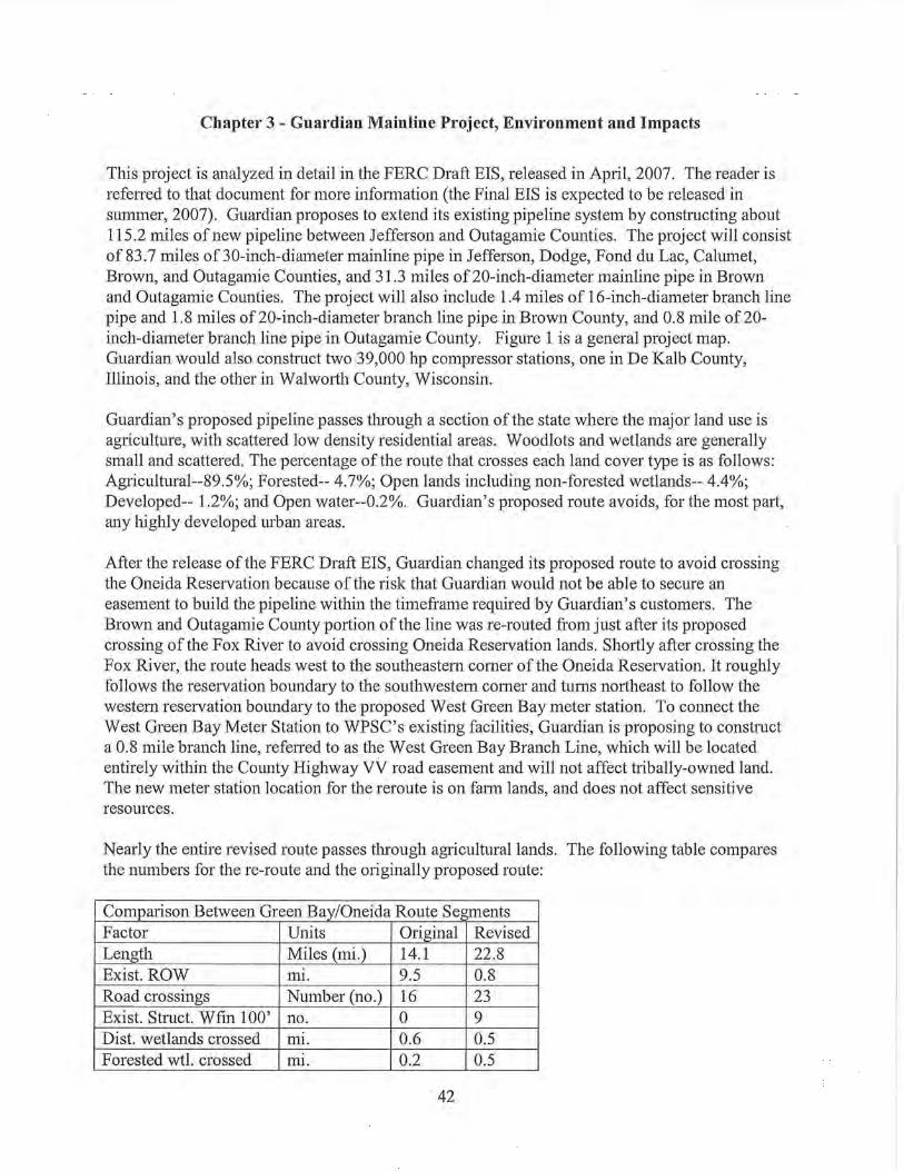
Chapter 3- Guardian Mainline Project, Environment and Impacts
This project is analyzed in detail in the FERC Draft EIS, released in April, 2007. The reader is refened to that document for more information (the Final EIS is expected to be released in summer, 2007). Guardian proposes to extend its existing pipeline system by constructing about 115.2 miles of new pipeline between Jefferson and Outagamie Counties. The project will consist of 83.7 miles of 30-inch-diameter mainline pipe in Jefferson, Dodge, Fond duLac, Calumet, Brown, and Outagamie Counties, and 31.3 miles of 20-inch-diameter mainline pipe in Brown and Outagamie Counties. The project will also include 1.4 miles of 16-inch-diameter branch line pipe and 1.8 miles of20-inch-diameter branch line pipe in Brown County, and 0.8 mile of20-inch-diameter branch line pipe in Outagamie County. Figure 1 is a general project map. Guardian would also construct two 39,000 hp compressor stations, one in De Kalb County, Illinois, and the other in Walworth County, Wisconsin.
Guardian's proposed pipeline passes through a section of the state where the major land use is agriculture, with scattered low density residential areas. Woodlots and wetlands are generally small and scattered. The percentage of the route that crosses each land cover type is as follows: Agricultural--89.5%; Forested-- 4.7%; Open lands including non-forested wetlands-- 4.4%; Developed-- 1.2%; and Open water--0.2%. Guardian's proposed route avoids, for the most part, any highly developed urban areas.
After the release of the FERC Draft EIS, Guardian changed its proposed route to avoid crossing the Oneida Reservation because of the risk that Guardian would not be able to secure an easement to build the pipeline within the timeframe required by Guardian's customers. The Brown and Outagamie County portion of the line was re-routed from just after its proposed crossing of the Fox River to avoid crossing Oneida Reservation lands. Shortly after crossing the Fox River, the route heads west to the southeastern comer of the Oneida Reservation. It roughly follows the reservation boundary to the southwestern comer and turns northeast to follow the western reservation boundary to the proposed West Green Bay meter station. To connect the West Green Bay Meter Station to WPSC's existing facilities, Guardian is proposing to construct a 0.8 mile branch line, refened to as the West Green Bay Branch Line, which will be located entirely within the County Highway VV road easement and will not affect tribally-owned land. The new meter station location for the reroute is on farm lands, and does not affect sensitive resources.
Nearly the entire revised route passes through agricultural lands. The following table compares the numbers for the re-route and the originally proposed route:
Comparison Between Green Bay/Oneida Route Segments Factor Units Original Revised Length Miles (mi.) 14.1 22.8 Exist. ROW mi. 9.5 0.8 Road crossings Number (no.) 16 23 Exist. Struct. Wfin 100' no. 0 9 Dist. wetlands crossed ml. 0.6 0.5 Forested wtl. crossed ml. 0.2 0.5
42

Water body crossings no. 20 23 Forest land crossed ml. 0.8 0.8 Ag. land crossed ml. 11.6 20.5 Open land crossed mi. 1.6 0.9 Land owners affected no. 46 77 Length on Oneida lands ml. 7.6 0.0
Rare Species and Communities
After reviewing information on habitat characteristics within the project area, the FWS indicated that two of the federally-listed species potentially occurring in the project area, the bald eagle and the eastern prairie fringed orchid, should be further evaluated for potential presence along the proposed route. Both the bald eagle and the eastern prairie fringed orchid are federally-listed as threatened. The bald eagle is also a state special concern species and the eastern prairie fringed orchid is state-listed as endangered.
The FWS identified records of bald eagle nests within about 0.5 mile of the original Fox River crossing location. If nests were found within a similar distance of the new crossing, the FWS would determine whether construction activities would be close enough to disturb nesting activities and if so, whether timing restrictions should be applied. Guardian would obtain updated monitoring information in 2007 and 2008 from the DNR and FWS prior to construction and reconfirm appropriate measures to avoid or minimize impact to the bald eagle.
The eastern prairie fringed orchid was identified near the proposed G-2 pipeline route in Jefferson County. The FWS recommended that Guardian screen the project corridor for suitable habitat for the eastern prairie (white) fringed orchid. This species prefers mesic prairies, especially on calcareous, rich, sandy or deep black soils, and degraded sedge meadows. Guardian conducted habitat screening during its wetland delineation field surveys and found no suitable habitat for this species. Both FWS and DNR concur with the conclusion that suitable habitat is not present. However, should suitable habitat or individuals of the species be identified during wetland field surveys and/or construction, Guardian would continue its consultation with the FWS, and would implement the measures recommended by the FWS to avoid, minimize, or mitigate potential impacts on this federally-listed plant species.
To investigate the presence of state-listed species in the vicinity of the project area, Guardian used NHI data obtained from the DNR's Bureau of Endangered Resources. Guardian generated data regarding known occurrences of individual species using a two-mile-wide buffer, which produced 16 listed species occunences, including four species that are state-listed endangered and threatened species, and 12 that are designated as species of special concern. Two of the species, the bald eagle and the eastern prairie fringed orchid, have already been discussed.
Guardian has completed consultations with the DNR to identify the specific state-listed species and/or species of special concern that should be included in the species surveys for the G-2 Project. Those species with habitat that could potentially occur in the project area, such as the Blanchard's cricket frog, wood turtle, Blanding's turtle, and rare plant species, could experience
43

reduced habitat quality or mortality (e.g., crushing or trampling) if areas they occupy are disturbed during construction.
The two snail species are associated with moist, cool, shady conditions, and calcareous groundwater seepage, are found along the Niagara Escarpment. Habitat for these snails is not present within the area that would be affected by pipeline construction.
Guardian has completed fall surveys for yellow gentian and forked aster and did not find these species. Additional surveys for the remaining rare plants, birds, reptiles and amphibians or their habitat were completed during the optimal time of the year in the spring of2007. If these species or their suitable habitat are present, the DNR would identify measures to avoid impacts to these species that include:
• exclusion fencing to prevent animals from entering the workspace
• restricting the work schedule to coincide with periods when the animal is hibernating and inactive or when birds are not breeding or nesting
• adjusting the workspace to avoid rare plant populations
• restoration of essential habitat elements to pre-construction conditions or better
In conclusion, there are several state or federal rare species known to occur near or within the counties traversed by the Gil pipeline. Several of these species require habitat conditions, e.g., alkaline wetlands, algific cliffs, etc., that are not present along the proposed pipeline route. Guardian has already completed surveys for some of the species and would complete the remainder of the surveys in spring 2007. Both the FWS and DNR have established measures to avoid or minimize impacts to those rare species such that significant impact to any of these species is unlikely.
Federal and State-listed Endangered and Threatened Species Potentially Occurring in the Vicinity of the Proposed Guardian Expansion Project
Species Federal Status State Status * Notes
FEDERALLY LISTED SPECIES
bald eagle Threatened WI-SC Two nests identified within 0.5 mile of the Fox (Haliaeetus /eucocephalus) River crossing. Pre-construction surveys
recommended in this area to document nesting activity.
eastern prairie fringed orchid Threatened WI - Endangered This species may be found in moist soil wetlands (Piatanthera leucophaea) and wet prairies.
WISCONSIN-LISTED SPECIES
Blanchard's cricket frog -- WI - Endangered Historically, the range of this species in Wisconsin (Acris crepitans blanchard!) is limited to the southern half of the state. Mud
flats and stream banks with abundant, low emergent vegetation are preferred habitats. Also inhabit marshes, fens, and wet prairies near permanent and flowing water.
44

Federal and State-listed Endangered and Threatened Species Potentially Occurring in the Vicinity of the Proposed Guardian Expansion Project
Species Federal Status State Status • Notes
Blanding's turtle .. WI -Threatened Found throughout the state, except the extreme (Emydoidea blandingit) north-central. Concentrated in the vast marshes
along the Wisconsin River. Primarily inhabit marshes and the shallow bays of lakes, but also utilize shallow, slow-moving rivers and steams.
wood turtle .. WI -Threatened Primarily found along the Black, Wisconsin, St. (Ciemmys inscu/pta) Croix, Brule, and Baraboo Rivers. Forage in
deciduous forests and open meadows adjacent to these rivers during the summer. Some individuals may inhabit rivers year round.
handsome sedge .. WI - Threatened Difficult to identify in the field . Only two known (Carex formosa) sites in Wisconsin . This specie range in Wisconsin
includes Door, Brown, Milwaukee, Outagamie, and Ozaukee Counties.
northern yellow lady's-slipper .. WI-SC Generally found in calcareous fens, but may also (Cypripedium parviflorum var. be found in other wet sites, especially with organic-makasir) rich or sandy soils.
a land snail (Catinella gelida)
WI-SC/N Found in terrestrial deciduous forests. · -
honey vertigo .. WI-SC/N Found in terrestrial deciduous forests. (Vertigo tridentata)
thin-lip vallonia .. WI-SC/N Found in terrestrial deciduous forests along (Vallonia perspectiva) streams and creeks.
side-swimmer .. WI-SC/N Marsh, lake, and stream bottoms. (Crangonyx gracilis)
redside dace .. WI-SC/N Typically occur in clear, cool headwaters of river (Ciinostomus elongatus) systems. Streams are generally small with
moderate to high gradients, adequate overhanging vegetation to provide ample shading of the stream, abundant coarse woody debris, and clean substrates of gravel, sand, cobble and bedrock.
two-spotted skipper .. WI-SC/N Found inhabiting marshes, bogs, wet stream sides (Euphyes bimacu/a) and wet sedge meadows.
northern harrier (Circus cyaneus) WI-SC/M
Found in retired cropland (timothy/quackgrass), old .. field habitat, sedge meadow, and restored prairies
yellow-billed cuckoo (Coccyzus Open woodlands with dense undergrowth,
americanus) .. WI-SC/M overgrown orchards and pastures, moist thickets
and willow groves along stream banks
black-throated blue warbler (Dendroica caerulescens) -· WI-SC/M
Found in dense hardwood or coniferous undergrowth of mesic deciduous forests
prothonotary warbler Cavity nester along dense hardwood forests along (Protonotaria citrea) streams and in swamps -- WI-SC/M western meadowlark (Sturnella neglecta)
WI -SC/M Meadows, plains, prairies , cropland and other -- open grasslands
• SC = Special Concern Species. SC/N = no laws regulating use, possession, or harvesting. SC/M =fully protected by federal and state laws under the Migratory Bird Treaty Act.
45

The proposed Bluff Creek Compressor Station in T4N R16E Section 30 is near the Southern Unit Kettle Moraine State Forest, a State Natural Area, and other DNR managed lands. No state threatened or endangered species occur in Section 30, but tlu·eatened and endangered species do occur within a mile of section 30.
Surface Waters
The proposed Guardian mainline and branch lines would cross 114 waterways, including 27 perennial streams, 86 intermittent streams, and 1 pond4
• Guardian evaluated each water crossing and developed an initial construction crossing method for each based on stream width and depth, flow rates, adjacent topography, vegetation, and the cost ofthe possible crossing methods. Guardian, and DNR review staff later visited some crossing locations, and further consideration was given to special resources present (including tlu·eatened, endangered and special concern species), other physical constraints and limitations (such as concrete bridge footings), and seasonal flow patterns at specific crossings.
This process led to a final set of proposed crossing methods presented in the permit applications. In addition, DNR pe1mits will require isolating the work zone from the waterway at all waterway crossings unless the waterway is dry or has no flow for the duration of the work below the ordinary high water mark. Guardian's DNR permit application identifies the waterways along the proposed G-2 mainline route, their location, and the proposed crossing construction method for each. Site specific plans for the waterways crossings are also included.
Guardian proposes to install the pipeline using horizontal directional drilling (HDD) at six of the waterways. No changes to the bed of these waterways or their water quality are expected to result from the pipeline installation if the HDD crossing method is successful (see general description of this crossing method for details).
Guardian proposes to install the pipeline using open-cut trenching for all 81 intermittent streams with no flowing water. Open cut trenching during no-flow periods would not be expected to alter the streams' water quality, streambed configuration, or flow characteristics. This technique also allows the crossing to be completed in the shortest time.
If a stream has flowing water, Guardian would utilize either the dam and flume technique or the dam and pump technique. Guardian has stated that if there is water flowing at the time of construction, a temporary sandbag cofferdam and pump or flume would be placed in the stream in order to isolate the work area.
The evaluation of potential impacts from crossing waterways using any of these open trench methods assumes that the DNR waterway permit would require use of appropriate erosion control practices along with the restoration ofthe streambed contours to preconstruction conditions.
4 The only stream crossed by a branch line is an intermittent stream classified as limited forage fish.
46

Wetlands
The proposed Guardian II natural gas pipeline route intersects 99 wetlands. The wetlands impacted include (based on dominant type) 80 emergent and mixed, 3 scrub/shrub (1 mixed), and 16 forested/mixed wetlands. Guardian will construct the pipeline across 43 farmed emergent wetlands using standard construction widths. The construction footprint in non-farmed wetlands would be 75 feet. The total area of wetlands within the construction zone is 63.9 acres. The Application for Waterway/Wetland Permits submitted to the DNR identifies these wetlands, and the wetland types and crossing locations along the proposed mainline route.
Four of the wetland plant communities that would be crossed by the mainline have a Floristic Quality Index (FQI) above 20. The wetlands are located near milepost (MP) 69.7, 73.7, 102.5, and 1 02.6. An FQI value below 20 generally indicates a disturbed plant community, while an FQI value above 20 generally indicates a plant community that is relatively undisturbed and possesses high floristic qualities. Because not all wetlands along the proposed route have been field delineated, additional wetlands may have FQI values above 20.
Many of the wet meadows have or are dominated by reed canary grass. The likelihood of reed canary grass remaining dominant in these wetlands following construction is high. In wetlands with reed canary grass, it is likely the ROW and workspace area would be dominated by reed canary because of the ground disturbance and movement of the plant rhizomes by construction machinery, which facilitate its' spread. A wetland that does not currently have reed canary grass would be protected from its introduction by construction mitigation techniques that will be required for the project.
The evaluation of potential impacts from crossing wetlands is based on the DNR waterway and wetland permit requiring the use of appropriate erosion control practices along with the restoration of the wetland contours and vegetation to preconstruction conditions.
47
Chapter 4- WG Hartford/West Bend Lateral Project, Environment and Impacts
The Hartford/West Bend lateral proposed by WG involves constmction oftwo segments. The Hartford segment consists of about 10 miles of 12-inch diameter gas pipeline in Dodge and Washington Counties. This segment would connect the Guardian extension to the existing WG distribution system in the Hartford area. The second segment, the West Bend segment, consists of about four miles of 12-inch diameter gas line in Washington County to connect the existing distribution systems in Hartford and West Bend areas. These two segments of new pipeline are jointly referred to as the "Hartford/West Bend lateral." Figures 2 and 3 show the proposed routes.
The Hartford segment permanent easement would be 50 feet wide with an additional temporary easement of 50 feet, for a total of 100 feet. Portions of the Hattford segment would be reduced to 75 feet to minimize disturbance to environmentally sensitive areas such as wetlands, waterways, and forests. The West Bend segment would be built completely within the existing road ROW.
The proposed Harford segment is located in an area where the major land use is agriculture, with scattered low density residential areas. Small patches of woodlots and wetlands are present. The proposed route for the Hartford segment would require easements on private lands, with most of the route crossing through agricultural fields.
The proposed route for the West Bend segment is within the existing ROW of a county highway. The adjacent lands are a mixture of agricultural, residential and commercial development.
Rare Species and Communities
Natural habitat is present along the Hartford segment of this lateral primarily where wetlands and waterways are crossed. The following natural community occurrences are recorded near the Hartford/West Bend lateral: northern wet forest, shrub-carr, southern mesic forest, southern tamarack swamp and calcareous fen.
About two acres of a southern mesic forest would be cleared in the vicinity ofWoodland Creek. A 75 foot-wide ROW would be cleared of trees for constmction. A 50-foot wide permanent ROW would be retained following constmction, which would be kept free oftrees to facilitate access and inspection of the pipeline. WG does not propose restoration or replacement of any forest tree losses. This forest is approximately 0.25 miles north of an NHI southern mesic forest natural community occurrence identified as Thomas Woodland. The wetland community that lies between Thomas Woodland and the affected woodland is a combination of sedge fen and shrub-carr with good species diversity. The value of the affected area is that it is contiguous with wetlands and other woodlands. Because of this it provides more habitat resources for plants and animals than isolated wetlands or woodlots alone. The incremental losses of forest-wetland communities in this ecological landscape, while small, may still have an important cumulative effect.
48

The NHI review for this lateral yielded three special concern plant species; one endangered and one special concern butterfly species; another special concern insect; two special concern snail species; and one threatened turtle. All of these species, with the exception of one of the plants, prefers moist (wetlands or wooded wetlands) or aquatic habitats. Most of these species also prefer alkaline conditions. WG completed field surveys during 2006 and did not observe any of these species. Suitable habitat for the rare turtle species may be present in the project area. Not all the sites were accessible, however. Additional assessments and species surveys would be conducted during 2007 prior to construction.
The West Bend segment of this lateral would be located in road ROW that is adjacent to agricultural and residential development. The NHI database identified floodplain forest and northern-wet mesic forest, but neither of these are proximate to the proposed lateral. On this segment the NHI database indicates that two special concern and one threatened fish species; one threatened turtle species; one threatened snake; one endangered and two special concern plant species may be present.
Habitat for the Blanding's turtle is unsuitable due to the lack of suitable vegetation cover and stream conditions. Habitat for the rare plant species is also unsuitable due to the lack of forest cover in the disturbed areas. One rare fish species may be present in Quaas Creek. This crossing would be installed using HDD construction, which would avoid any direct disturbance to the waterway. As an additional protection measure, DNR staff has requested that the HDD work be scheduled around the spawning season for rare fish species, which is generally from May 15 to the end of August. 5
Potential impacts to the Butler's garter snake were also evaluated. Due to the size and quality of suitable Butler's garter snake habitat, the site was classified as a potential Tier 1 Site (Site of Minimal Conservation Value). As a result, the site is covered under the broad Incidental Take Authorization for Tier 1 Butler's Garter Snake Sites. The authorization indicates that no conservation measures are required, but DNR staff has recommended that WG implement the voluntary conservation measures described within the conservation strategy to benefit the snake at this site.
Surface Waters
Construction of the proposed Hartford segment pipeline in Dodge and Washington Counties would require nine waterbody crossings. Included are three crossings of named streams, one of Butler Creek and two of Woodland Creek. There would be up to seven crossings of unnamed, intermittent streams.
Construction of the proposed West Bend segment pipeline in Washington County would require four waterway crossings. There are two crossings of named streams, Evergreen Creek and Quaas Creek; both are Areas of Special Natural Resource Interest due to the presence of aquatic Species of Concern. There are two crossings ofunnamed, intermittent streams; one is tributary to Evergreen Creek and one is tributmy to Quaas Creek.
5 Note that this time period was intended to cover the spawning period of the rare fish species that may be present; many other fish have spawning periods that are earlier.
49

Information about fisheries was collected through contacts with DNR field personnel. The streams crossed by the Hartford segment are wam1-water forage fisheries. Watm-water fisheries are wann-water streams/rivers which support fish; the smaller streams typically support a diverse community of forage fish, rather than sport fish. The spawning seasons for most warm-water fish species occur between April and the end of June.
The following table briefly describes the waterways along the proposed WG Hartford segment route and the proposed crossing construction method for each. Numbering is from west to east.
Hartford Stream Name Type2 Proposed Road Location or Associated
Stream# (UNT1) Crossing milepost Wetland#
Method3
1 UNT to Hepp Cr. Intermittent Open trench @State Rd. 67
2 Woodland Creek Intermittent RR Thomas
trib to Wildcat Cr (with flow) Jack and Bore
H-14a
3 Woodland Creek Intermittent Thomas
(with flow) Open trench
H-14
4 UNT to Butler Intermittent Open trench
E. of St. Johns
Rd. ~2,000'
5 UNT to Butler Intermittent E. of CTH P Jankowski Open trench
H-13b
6 UNT to Butler Intermittent E. of CTH P, W. W. Klink Open trench
of CTH NP Woods H-13h
7 UNT to Butler Intermittent Open trench
W. of CTH NP E. Klink
Woods
8 Butler Creek Perennial E. & N of CTH NP H-15
tributary to Open trench
Rubicon River
9 UNT to Butler Intermittent E. of Goodland Open trench
Rd.
1 Unnamed tributary. 2 Based on 7.5 minute USGS Topographic quad maps. 3 HOD = Horizontal Directional Drill; Open trench (no flow) = trenching without any stream isolation or bypass, limited
to times of no stream flow; Isolation Trenching = use of Dam and Pump or Dam and Flume crossing methods to isolate
trench area from stream flow.
Both named streams crossed by the West Bend segment pipeline are Areas of Special Natural Resource Interest waters. Potential impacts to in-stream organisms would be avoided by the chosen construction method and timing the crossing to avoid sensitive periods of the species' life cycles.
50
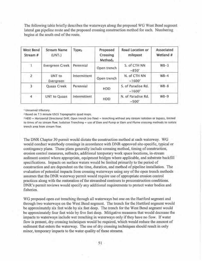
The following table briefly describes the waterways along the proposed WG West Bend segment lateral gas pipeline route and the proposed crossing construction method for each. Numbering begins at the south end of the route.
West Bend Stream Name Type2 Proposed Road Location or Associated
Stream# (UNT1) Crossing milepost Wetland#
Method3
1 Evergreen Creek Perennial S. of CTH NN WB-3 Open trench
~850'
2 UNT to Intermittent N. of CTH NN WB-4
Everqreen Open trench
~ 1600'
3 Quaas Creek Perennial S. of Paradise Rd. WB-8 HDD
~ 1600'
4 UNT to Quaas Intermittent N. of Paradise Rd. WB-9 HDD
~sao·
1 Unnamed tributary. 2 Based on 7.5 minute USGS Topographic quad maps.
3 HDD = Horizontal Directional Drill; Open trench (no flow) = trenching without any stream isolation or bypass, limited
to times of no stream flow; Isolation Trenching = use of Dam and Pump or Dam and Flume crossing methods to isolate
trench area from stream flow.
The DNR Chapter 30 pe1mit would dictate the construction method at each waterway. WG would conduct waterbody crossings in accordance with DNR-approved site-specific, typical or contingency plans. These plans generally include crossing method, timing of construction, erosion control measures, setbacks, additional temporary work space locations, in-stream sediment control where appropriate, equipment bridges where applicable, and substrate backfill specifications. Impacts on surface waters would be limited primarily to the period of construction and are dependent on the time, duration, and method of pipeline installation. The evaluation of potential impacts from crossing waterways using any of the open trench methods assumes that the DNR waterway petmit would require use of appropriate erosion control practices along with the restoration of the streambed contours to preconstruction conditions. DNR's permit reviews would specify any additional requirements to protect water bodies and fisheries.
WG proposed open cut trenching through all wate1ways but one on the Hartford segment and through two waterways on the West Bend segment. The trench for the Hartford segment would be approximately six feet wide by six feet deep. The trench for the West Bend segment would be approximately four feet wide by five feet deep. Mitigative measures that would decrease the impacts to waterways include wet trenching in waterways only if they have no flow. If water flow is present, dry crossing techniques would be required, which would reduce the amount of sediment that enters the waterway. The use of dry crossing techniques should result in only minor, temporary impacts to the water quality ofthese streams.
51

One pipeline crossing of Woodland Creek on the Hmiford Segment would occur using the jack and bore method. This stream crossing is incorporated with the underground bore of the railroad bed, which the stream parallels. Successful boring beneath the waterway would eliminate the potential environmental effects of pipeline construction on the waterbody. The DNR permit will require that the second pipeline crossing of Woodland Creek and associated wetland and the crossing of Butler Creek and associated wetlands will be installed by HDD. Both waterways provide quality fish habitat. WG modified its initial application to use HDD installation in these two locations.
WG cunently proposes to directionally drill two wate1way crossings on the West Bend segment, Quaas Creek and an unnamed tributary to Quaas Creek. Directional drilling minimizes the environmental effects of pipeline construction on a waterbody by going beneath the stream and avoiding disturbance ofthe stream bed and banks.
Wetlands
The Hmiford segment of this lateral crosses 15 wetlands and the West Bend segment crosses 14. The construction footprint through wetlands located in agricultural or other open lands would be a total of75 feet wide; 50 feet would be permanent easement along with 25 feet of temporary construction easement. The construction work space needed for the portions of the lateral that are within road ROWs varies depending on the size of pipeline, ROW space available and topography. The total area ofwetland impact is 11.3 acres on the Hartford segment. Six wetlands include areas of shmb-carr vegetation, four are fresh wet meadows, two are hardwood swamps and five wetlands are farmed wetlands. The total area of wetland impact on the West Bend segment is 1.2 acres and is in the road right-of-way. Five wetlands on the West Bend segment are shallow marshes, six are fresh wet meadows, five are shmb-cans and one is a sedge meadow.
Direct impacts to the trenched wetlands would include an approximate 6-foot wide trench and a 35-foot spoil pile adjacent to the trench.
The following tables identify the wetlands along the proposed Hartford/West Bend Lateral routes and the proposed crossing construction method for each. The wetland reference numbers conespond to the identification numbers used by WG in its application materials. Some differences exist between the application and subsequent data request responses. This EA uses the initial application data.
Wetland Wetland Type Impact Proposed Crossing Approximate # (acres) Method* Milepost Location
WB-1 Shallow Marsh 0.13 Open-cut trench 0.4 WB-2 Fresh wet meadow 0.17 Open-cut h·ench 0.7
and shallow marsh WB-3 Sedge Meadow 0.08 Open-cut trench 1.0
WB-4b Fresh wet meadow 0.04 Open-cut trench 1.4 WB-5a Shallow Marsh 0.03 Open-cut h·ench 2.3 WB-5b Shmb-can 0.01 Open-cut trench 2.2 WB-5c Fresh wet meadow 0.12 Open-cut trench 2.2
52
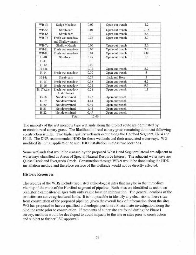
WB-5d Sedge Meadow 0.09 Open-cut h·ench 2.2
WB-5e Shrub-can 0.01 Open-cut h·ench 2.15 WB-6b Shmb-can 0 Open-cut h·ench 2.4 WB-7b Fresh wet meadow 0.36 Open-cut h·ench 2.7
and Shallow marsh WB-7c Shallow Marsh 0.05 Open-cut h·ench 2.6 WB-8b Fresh wet meadow 0.03 Open-cut h·ench 2.8 WB-8c Fresh wet meadow 0.04 Open-cut h·ench 2.85 H-10 Shrub-can 0.27 Open-cut trench 1.8 H-11 0 H-12 0.00 H-13c 0.72 Open-cut h·ench 5.2 H-14 Fresh wet meadow 0.79 Open-cut h·ench 3
H-14a Shrub-can 0.29 Jack and Bore 3 H-15 Fresh wet meadow 0.35 Open-cut trench 6.2 H-16 Fresh wet meadow 0.22 Open-cut trench 9.5
H-17a,b,c Fresh wet meadow 0.38 Open-cut h·ench 1.1 & sluub-can
H-18 Not determined 1.72 Open-cut trench H-19 Not determined 4.14 Open-cut h·ench H-20 Not detennined 0.49 Open-cut trench H-21 Not detennined 1.44 Open-cut trench H-22 Not determined 0.49 Open-cut trench
Total 12.46
The majority of the wet meadow type wetlands along the project route are dominated by or contain reed canary grass. The likelihood of reed canary grass remaining dominant following construction is high. Two higher quality wetlands occur along the Hartford Segment, H-14 and H-15. The DNR recommended HDD for these wetlands and their associated waterways. WG modified its initial application to use HDD installation in these two locations.
Some wetlands that would be crossed by the proposed West Bend Segment lateral are adjacent to wate1ways classified as Areas of Special Natural Resource Interest. The adjacent waterways are Quaas Creek and Evergreen Creek. Construction through WB-9 would be done using the HDD installation method and therefore surface of the wetlands would not be directly affected.
Historic Resources
The records of the WHS include two listed archeological sites that may be in the immediate vicinity of the route of the Hartford segment of pipeline. Both sites are identified as unknown prehistoric campsites/villages with only vague location information. The general locations ofthe two sites are active agricultural lands. It is not possible to identify any clear risk to these sites from construction of the proposed pipeline, given the overall lack of information about the sites. WG has proposed to have a qualified archeologist perform a Phase I site investigation along the pipeline route prior to construction. If remnants of either site are found during the Phase I survey, methods would be developed to avoid impacts to the site or sites prior to construction and subject to further PSC approval.
53
•

•
There is also a European era cemetery site adjacent to the route ofthe West Bend segment ofthis pipeline. Existing records regarding the cemetery are contradictory, with conflicting comments on whether or not the cemetery's burials have been moved to another location. No surface features of the cemetery are present and the area is in agricultural production. WG has proposed to have a qualified archeologist perform a Phase I site investigation along the pipeline route prior to construction. If any remnants of the cemetery are found during the Phase I survey, WG has indicated it would relocate the gas pipeline to the other side of the road in this location.
No other known archeological or other historic resources were identified in the records of the WHS that appear to be at risk from construction of the proposed Hartford/West Bend lateral pipeline .
54

Chapter 5- WG and WE Fox Valley Lateral Project, Environment and Impacts
The Fox Valley lateral consists of four segments. The overall project crosses from agricultural lands into an expanding urban area. The primary land cover in the project area is a mix of agriculture and urban development. Woodlands, wetlands, and other natural land covers are found in small and scattered patches. Figure 4 shows the proposed routes.
Segment 1 is a 20-inch pipe that runs west from the new Guardian pipeline to the intersection of CTH CE and STH 55. WG and WE provided information on two route options for Segment 1. The Southern route option was selected by the PSC. Approximately the first 4 miles of the south route option crosses agricultural lands and is located within an existing electric transmission line ROW. The remaining 1 Y2 miles crosses agricultural lands that is being converted to residential and commercial developments. The PSCW approved the southern route.
Segment 2 is an 8-inch pipe that extends north for about 1 'l4 miles from CTH CE and STH 55 into Kaukauna. This segment follows an old railroad bed that parallels Kankapot Creek through a generally wooded area. The old railroad bed has been converted into a recreational trail. A large electric distribution line also follows this alignment.
Segment 3 consists of about 4.7 miles of 16-inch pipeline that would be built primarily within road ROW, passing through an area that is entirely urban development.
Segment 4 is a 13,500-foot 12-inch main located north ofthe Fox River, following railroad and road ROW through an area that is mixed residential and commercial developments.
Rare Species And Communities
The proposed Fox Valley lateral would be built in an area that is primarily agricultural and urban in nature. The NHI indicates, however, that southern dry-mesic and northern mesic forest communities are present in the general area. In addition, three special concern and five threatened plant species, one special concern crustacean, one special concern bird species were also identified in the project area. The longest distance of natural habitat that would be crossed by the project is on Segment 2, which runs parallel to Kankapot Creek along a recreational trail and utility easement. Construction along this segment would occur in maintained ROW areas and there would not be any additional clearing of wooded areas.
The south option for Segment 1 (along the transmission line corridor) crosses a few small woodlots. The rare plant species identified by the NHI are unlikely to be present along this route option because of historical disturbance and the extensive overlapping of the gas line route with an existing electric line ROW. Overall the south route option crosses through or past more small wetland areas and woodlots than the north route option.
The bald eagle is present in the project area. Monitoring data from 2006 indicates active nests are more than 'l4 mile from Segment 2, the closest location to the proposed project. Based on this, no impacts to nesting eagles are expected from construction of the proposed Fox Valley
55

lateral. The nesting status of eagles in the area would be updated annually during construction using the most cunent monitoring data from the DNR.
Surface Waters
Construction of Segment 1 would have up to eight waterway crossings. Three crossings are through perennial streams, one of which is Kankapot Creek. All waterways, both perennial and intermittent, are ttibutaries to Kankapot Creek, and all are warm-water streams, mainly forage fish communities.
Construction of Segment 2 would involve two crossings of Kankapot Creek. The pipeline would also parallel the stream for a distance of approximately Yz mile.
Segment 3 crosses a perennial stream named Garners Creek, three intermittent streams that are tributary to Garners Creek, and one intermittent stream, in a residential area, that is a tributary to the Fox River. This segment is within road ROW.
Finally, Segment 4 includes two crossings of intermittent streams that are tributary to an unnamed creek flowing to the Fox River. Segment 4 is within road ROW.
All waterways impacted by the pipeline construction are streams of the Lower Fox River Basin. None of the streams being crossed is designated as an Area of Special Natural Resource Interest; however the Fox River is an ASNRI and many of the streams are closely connected.
Information about fisheries was collected through contacts with DNR field personnel. The streams crossed by the Fox Valley lateral pipeline are warm-water fisheries. Warm-water fisheries are warm-water streams/rivers which support fish; the smaller streams typically suppmi a diverse community of forage fish, rather than sport fish. The spawning season for most warmwater fish species occurs between April and the end of June. The water quality in the streams of this area has been generally affected by agriculture and is more recently affected by rapid urbanization.
The following table briefly describes the waterways along the proposed lateral gas pipeline route segments and the proposed crossing construction method for each. Numbeting starts at the east end of the route.
Segment Stream Name Type2 Proposed Crossing Road Location or & (UNT,) Method milepost
Stream# lS4- 1 UNT to Kankapot Intermittent Trench ~0.16 mi E of
Brant St. John Rd. lS - 2 UNT to Kankapot Intermittent Trench ~0.25 mi Wof
Brant St. John Rd. lS - 3 UNT to Kankapot Intermittent Trench ~0.3 mi W of
Brant St. John Rd.
56

1S- 4 UNT to Kankapot Intermittent Trench ~0.5 mi W of Brant St. John Rd.
1S - 5 Kankapot Creek Perennial Trench ~0.5 mi E of N. Hmwood Rd.
1S- 6 UNT to Kankapot Perennial Trench ~0.3 mi W of N. Hmwood Rd.
1S -7 UNT to Kankapot Perennial Trench ~0.43 mi S of CTHKK
1S- 8 UNT to Kankapot Intermittent Trench ~0.3 miN of CTHKK
2- 1 Kankapot Creek Perennial Trench ~0.4 miN of CTHCE
2-2 Kankapot Creek Perennial Trench ~0.6 miN of CTHCE
3- 1 UNT to Garners Intermittent Trench ~0.06 mi E of Creek Debruin Rd.
3-2 UNT to Garners Intermittent Trench ~0.16 mi E of Creek Red Tail &
Buchanan Rds. 3 - 3 UNT to Garners Intermittent Trench ~0.3 mi E of CTH N
Creek along CTH CE 3-4 Garners Creek Perennial Trench 0.03 mi E ofCTH N
along CTH CE 3-5 UNTtoFox Intermittent Trench ~0.26 miN of
River CTH CE along Thelosen Dr.
4-1 UNT to Fox Intermittent Trench at CTH 00 & CTH E River
4 - 2 UNTto Fox Intermittent Trench at Glendale Ave. & River Sandra St.
1 Unnamed h·ibutary. 2 Based on 7.5 minute USGS Topographic quad maps. 3 HDD =Horizontal Directional Drill; Open h·ench (no flow)= trenching without any stream isolation or bypass, limited to times of no sh·eam flow; Isolation Trenching= use of Dam and Pump or Dam and Flume crossing methods to isolate trench area from sh·eam flow. 4 S = Segment 1 Southern route.
The DNR Chapter 30 permit will specify the construction method that can be used at each waterway. WG and WE would conduct waterbody crossings in accordance with DNR-approved site-specific, and typical or contingency plans covering the same activities and components as specified for the other projects. The evaluation of potential impacts from crossing waterways using any of the open trench methods assumes that the DNR waterway permit would require use of appropriate erosion control practices, along with the restoration of the streambed contours to preconstruction conditions. DNR's permit reviews would specify any additional requirements to protect water bodies and fisheries.
57

WG and WE proposed open cut trenching through all waterways. The trench would be approximately six feet wide by six feet deep for Segment 1. Trenches along both Segment 2 and Segment 4 would be approximately four feet wide by five feet deep and the Segment 3 trench size would be approximately five feet wide by five feet deep. Mitigative measures that would decrease the impacts to waterways include wet trenching in waterways only if they have no flow. If flow is present, dry crossing techniques would be required, which would decrease the amount of sediment that enters the waterway.
Following installation of the pipeline, the trench would be backfilled. Disturbed areas within the floodplains would be restored to the extent practicable to original ground elevations, and would be stabilized and reseeded with approved seed mixes. WG and WE would also be required to restore the preexisting slope, profile and substrate of stream bottoms in order to return the streams to pre-construction habitat values and hydrological functions. Pre- and post-construction streambed surveys would be required to assure all streams are restored to original conditions. The pre- and post-construction streambed surveys of each crossing are the best means of ensuring that the original stream morphology is restored and maintained after covering the pipeline. Long-term monitoring would be required to assure stream bed and bank recovery; follow-up restoration would be conducted, as needed. The use of dry crossing techniques should result in only minor, temporary impacts to the water quality of these streams.
Wetlands
The proposed Fox Valley lateral crosses 25 wetlands. The construction footprint through. wetlands located in agricultural or other open lands would be 75 feet wide, with 50 feet as permanent easement, along with 25 feet of temporary construction easement. The construction work space needed for the portions of the lateral that are within road ROWs varies depending on the size of pipeline, ROW space available and topography. The total area ofwetland affected by construction work space is 2.4 acres. The common segments ofthe routes, which generally are within road ROW (Segments 2, 3 and 4) cross wetlands that extend into the road ROW, including five fresh wet meadows, three sedge meadows, nine shallow marshes, one shrub-can, and one hardwood swamp. Along the south route option are three sedge meadows and three undelineated farmed wetlands.
Direct impacts to the trenched wetlands would include an approximate 6-foot wide trench and a 35-foot spoil pile adjacent to the trench.
The following table identifies the wetlands along the proposed Fox Valley Lateral routes and the proposed crossing construction method for each. The wetland reference numbers conespond to the identification numbers use by WG and WE in the application materials. Milepost locations were not provided by the applicant and have been estimated from aerial photos.
58
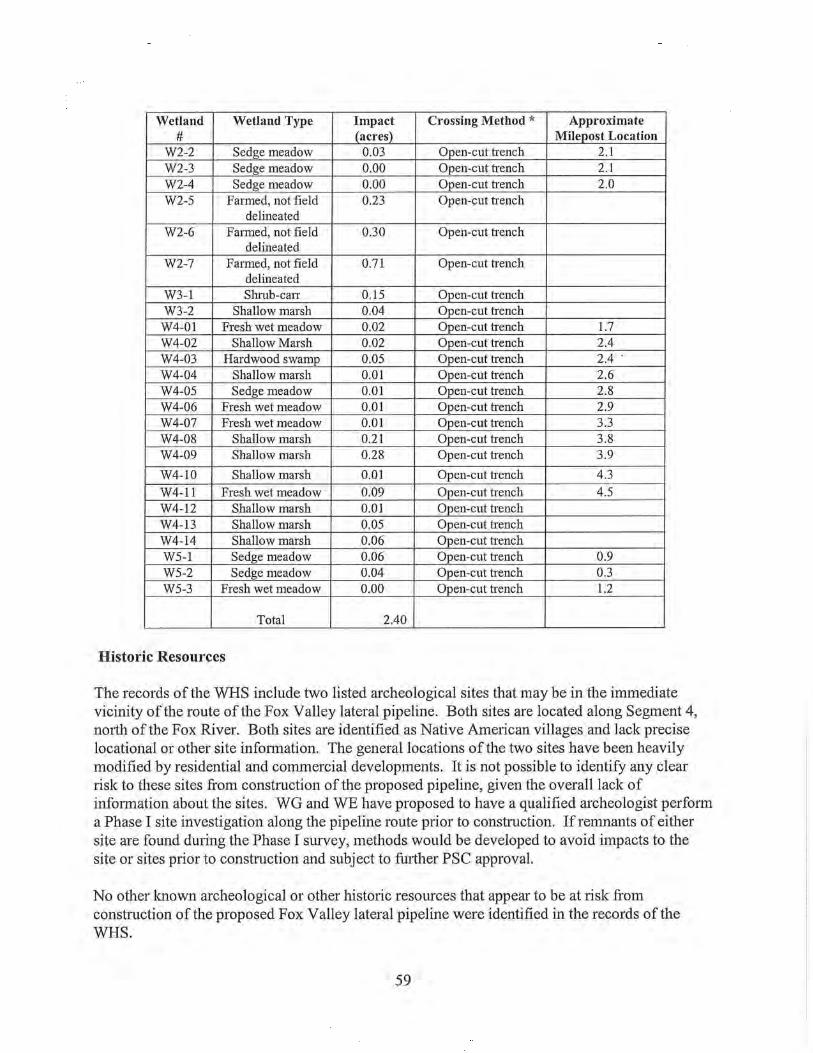
Wetland Wetland Type Impact Crossing Method * Approximate # (acres) Milepost Location
W2-2 Sedge meadow 0.03 Open-cut h·ench 2.1 W2-3 Sedge meadow 0.00 Open-cut h·ench 2.1 W2-4 Sedge meadow 0.00 Open-cut h·ench 2.0 W2-5 Farmed, not field 0.23 Open-cut h·ench
delineated W2-6 Fa1med, not field 0.30 Open-cut h·ench
delineated W2-7 Fa1med, not field 0.71 Open-cut trench
delineated W3-1 Shmb-can: 0.15 Open-cut trench W3-2 Shallow marsh 0.04 Open-cut h·ench
W4-01 Fresh wet meadow 0.02 Open-cut h·ench 1.7 W4-02 Shallow Marsh 0.02 Open-cut trench 2.4 W4-03 Hardwood swamp 0.05 Open-cut trench 2.4 W4-04 Shallow marsh 0.01 Open-cut trench 2.6 W4-05 Sedge meadow 0.01 Open-cut h·ench 2.8 W4-06 Fresh wet meadow 0.01 Open-cut h·ench 2.9 W4-07 Fresh wet meadow 0.01 Open-cut trench 3.3 W4-08 Shallow marsh 0.21 Open-cut trench 3.8 W4-09 Shallow marsh 0.28 Open-cut trench 3.9
W4-10 Shallow marsh 0.01 Open-cut h·ench 4.3 W4-11 Fresh wet meadow 0.09 Open-cut h·ench 4.5 W4-12 Shallow marsh 0.01 Open-cut h·ench W4-13 Shallow marsh 0.05 Open-cut trench W4-14 Shallow marsh 0.06 Open-cut h·ench W5-1 Sedge meadow 0.06 Open-cut trench 0.9 W5-2 Sedge meadow 0.04 Open-cut h·ench 0.3 W5-3 Fresh wet meadow 0.00 Open-cut trench 1.2
Total 2.40
Historic Resources
The records of the WHS include two listed archeological sites that may be in the immediate vicinity of the route of the Fox Valley lateral pipeline. Both sites are located along Segment 4, north of the Fox River. Both sites are identified as Native American villages and lack precise locational or other site information. The general locations ofthe two sites have been heavily modified by residential and commercial developments. It is not possible to identify any clear risk to these sites from construction of the proposed pipeline, given the overall lack of information about the sites. WG and WE have proposed to have a qualified archeologist perform a Phase I site investigation along the pipeline route prior to construction. If remnants of either site are found during the Phase I survey, methods would be developed to avoid impacts to the site or sites prior to construction and subject to further PSC approval.
No other known archeological or other historic resources that appear to be at risk from construction of the proposed Fox Valley lateral pipeline were identified in the records of the WHS.
59

Chapter 6- WPS Sheboygan Lateral Project, Environment and Impacts
The Sheboygan lateral proposed by WPS involves construction of about 33 miles of 16-, 14-, and 12-inch pipeline in Fond duLac and Sheboygan Counties. This lateral would connect the Guardian extension with WPS's existing distribution systems in the Plymouth and Sheboygan areas. Figure 5 is a general map of this lateral.
Most of the proposed route for the Sheboygan lateral would be adjacent to existing linear features. The ROW for this lateral is within an existing electric transmission line ROW for about 23 miles, adjacent to an existing natural gas line ROW for about three miles and next to a state highway for six miles. About one mile would be located along a fence line or a town road.
The Sheboygan lateral would pass through a large geographic feature known as the Kettle Moraine. This is an area with heavy deposits of uneven glacial till and much of the area is forested. The State of Wisconsin owns large blocks of this forest land and manages it as part of the Kettle Moraine State Forest (KMSF). The proposed gas pipeline would be located within an existing electric transmission line ROW when crossing the Kettle Moraine State Forest. The remainder of the proposed lateral route crosses lands where the major land use is agriculture, with scattered low density residential areas. Woodlots and wetland areas are generally small and scattered.
Rare Species and Communities
The NHI database search for this lateral yielded a large number of occurrences. Specific impacts and proposed mitigation measures by general taxonomic group are described below.
Several natural community types are identified in the project area: emergent marsh, shrub-carr, and northern wet, southern dry-mesic, wet-mesic and mesic forests. This lateral encompasses relatively more natural habitat than the other laterals and, because it includes the Northern Unit ofthe KMSF, the area has been more intensively surveyed. Outside the KMSF, some woodlots are crossed by the proposed route, as well as some natural habitats associated with crossings of the Onion River (including lands included in the Onion River stream bank restoration area), the Mullet River and Ben Nutt Creek. Through all of these areas, however, the proposed gas pipeline would be located within an existing electric transmission line ROW.
WPS estimates that it will do minimal tree clearing within the portion of the ROW that crosses the KMSF and most, if not all of these trees would be young saplings. The transmission line ROW that would be shared by the lateral pipeline within the KMSF is quite brushy, but the "brush" is composed primarily of native species. Weeds are present, but are not as dominant as in typical ROWs. In its present state, this corridor supports a number of native plants that do not occur in adjacent forested habitats. Dming construction, the entire ROW would be cleared of vegetation and thereafter, the ROW would continue to be maintained for the transmission line, but in addition a 4-foot wide pathway over the pipeline would be periodically cleared of shrubs to facilitate inspection of the pipeline.
60

North of the proposed shared ROW, the forest is dominated by mature oaks. The forest south of the ROW supports more pockets of aspen, some small openings, feathered edges, stands of younger forest, and nearby old fields. The forest in this area supports at least four statethreatened species. The high value of this forest is that it can be managed as a relatively large block, one of the few remaining in this ecoregion of the state that can support populations of rare forest birds. Given the significance ofthe KMSF as wildlife habitat, DNR staff at the KMSF will work with WPS to replace mature trees which are slow-growing and do not regenerate well if any are cut down for construction. Moreover, since the value of this ROW comes from the dominance of native species, controlling invasive species within the ROW to ensure reestablishment of native species would be important. The DNR will require WPS to provide a plan for monitoring and controlling invasive species within the ROW after construction as a condition of obtaining an easement.
Reptiles
Occurrences for the Butler's garter snake, listed as threatened in Wisconsin, have been recorded in the project area. The project area is outside of this species' general range. It is possible that the snake may have been introduced to the area. However, the DNR completed an evaluation of potential impacts consistent with the Butler's garter snake conservation strategy and concluded that the construction of the lateral was a temporary disturbance affecting less than 20% of the contiguous suitable habitat and therefore this action would fall under the broad Incidental Take Authorization for Temporary Habitat Disturbance for the Butler's Garter Snake authorized on August 3, 2004. 6 DNR's herpetologist has recommended that WPS implement the voluntary conservation measures described within the conservation strategy to benefit the snake at this site.
Occurrences of the Blanding's turtle (state threatened) and the queen snake (state endangered) have also been recorded in the project area. Additional assessment of habitat conditions for both species would be unde1iaken with the DNR to determine measures to avoid impacts to these species, either through constructing the pipeline during the species' inactive periods and/or the installation of exclusion fencing to ensure that individuals do not enter the construction area.
Fish
Two state-listed fish species may be present within the project area; however, both were identified in waterways that are not affected by the project.
Mussels and other invertebrates
Two state-listed mussel species and two special concern crustaceans may be present within the project area.
The waterway that supports the mussel species would be directionally bored. In the event of a frac-out, WPS would implement its proposed contingency measures to stop drilling and contain and recover the drilling mud.
6 For more information refer to: (http://dnr.wi.gov/org/landler/take/TempHab.htm).
61

The two crustacean species occurrences were recorded in waterways that are not affected by the project.
Birds
Based on NHI records and some surveys completed within the KMSF, at least four state-listed, and two special concern bird species are present near the project area. All of the state-listed species prefer forested habitat for nesting and or foraging. Therefore, there is no concern that they would be nesting within the ROW that passes through the KMSF, which is dominated by shrubs and herbaceous plants. However, a concern remains that construction activities within the ROW during the nesting season could result in avoidance of suitable nesting habitat adjacent to the ROW or abandonment of active nests. It is estimated that construction activities may influence bird behavior up to 2,000 feet into the forest adjacent to the ROW, based on the size of the species' tenitories. If active nests are abandoned, construction of this project may result in an incidental take subject to the Wisconsin Endangered Species Law. A survey for one of the four species has already been completed yielding negative results. The DNR is working with WPS to complete the remaining nesting surveys in June and July in areas adjacent to the ROW to determine the extent to which timing rest1ictions from April 15 to August 31 would be applied to activities in the KMSF, and adjacent areas. This timing restliction could be adjusted depending on the species, results of the surveys, and nest locations near the KMSF segment.
Two state special concern species, the northern harrier (Circus cyaneus) and the great-blue heron (Ardea herodias) occur in other locations along the lateral route. The northern harrier prefers to nest in retired cropland (timothy/quackgrass), old field habitat, sedge meadow, and restored prailies. The breeding season extends from early Aplil through late August. Northern harriers are distlibuted throughout the state; however, the construction disturbance would not result in a permanent loss of habitat and the impact would be temporary and is unlikely to be significant.
There is a small great blue heron rookery near one of the stream crossings for this lateral. The size and history of this rookery is unknown. The ROW where clearing would occur is approximately 400 to 500 feet from the rookery. The main disturbance would likely be from horizontal directional dlilling equipment that would be set up several hundred feet further away. Herons are sensitive to disturbance duling nesting, but the sensitivity in terms of the nature of the disturbance and distance to the rookery is unknown in this case. The DNR generally recommends that construction within 1,000 feet of heron nests should be avoided from mid-April to mid-July. At this site, it is likely that the boring would occur during this time peliod and would take approximately two weeks; however, the distance from the nests to the major boring disturbance is approximately 900 feet, which may be sufficient so as not to disturb nesting herons. The DNR has asked WPS to document the heron activity in the spring plior to construction in the area to confirn1 whether herons are indeed nesting at the site and if so, to document their activity as construction continues.
Plants
There are 6 state-listed and 9 special concern plant species identified in the NHI that are known to occur within the project area for this lateral. They are desclibed in the following table.
62

..
Rare Plant Species Listed as Near the Sheboygan Lateral Project Area
Name State Status * Notes seaside crowfoot THR This species is often found in brackish or (Ranuncu/us cymba/aria) alkaline places: sandy or muddy shores and
marshes, ditches and harbors along Lake Michigan, even salted roadsides near the city of Superior.
Cooper's milkvetch END This species prefers riverbanks, ravines, (Astragalus neg/ectus) lakeshores, and also old fields, and is often
found on dolomite near Lake Michigan . forked aster (Aster furcatus) THR This species prefers dry to mesic
hardwoods, and is often found on streamsides or slopes with dolomite near the surface.
yellow gentian (Gentiana THR This species has been observed in thin soil alba) in dry, open woodlands, ridges and bluffs
(often with dolomite near the surface), moist sand prairies and roadside ditches, and clay soils of wooded ravines.
marsh valerian THR The species prefers calcareous coniferous (threatened) (Valeriana swamps, often openings in northern wet sitchensis ssp u/iginosa) forests. small skullcap (Scutellaria END The species prefers dry, often dolomitic parvula var. parvula) cliffs and prairies. American sea rocket sc This plant is found on Lake Michigan (Caki/e edentu/a) beaches, and less commonly on dunes. northern yellow lady's sc This species prefers fens, calcareous slipper (Cypripedium swales, and rich springy forest edges. parviflorum var. makasin) tufted hairgrass sc This plant prefers fens, sandstone and (Deschampsia cespitosa) dolomite splash pools on the Great Lakes,
springs, marly bog pools, and cedar swamps.
many-headed sedge (Carex sc This plant prefers the muddy, sandy, marly, sychnocephala) and peatyshorelines of lakes and ponds. showy lady's slipper sc This species prefers neutral to alkaline ( Cypripedium reginae) forested wetlands, rich upland forests in
seeps, and moist to dry clay bluffs. yellow evening primrose sc This species prefers steep bluff prairies (Ca/y/ophus serrulatus) along the Mississippi and lower St. Croix
Rivers, cedar glades, and occasionally moister prairies .
marbleseed (Onosmodium sc This species prefers dry prairies and mol/e) woodlands. Blooming occurs throughout
the month of July. hairy beard tongue sc This species prefers dry gravelly and sandy (Penstemon hirsutus) prairies, or hillside oak woodlands, and can
be found naturalized on roadsides. fragrant sumac (Rhus sc This plant has been found in woodlands aromatica) with dolomite, or less commonly,
sandstone, near the surface.
* END = State Endangered; THR = State Threatened; SC = State Special Concern
Of these species, the American sea rocket, seaside crowfoot and Cooper's milkvetch, are associated with alkaline lake shores and Lake Michigan coastal habitat that would not be affected by the project. Most of the remaining species are associated with wet or dry prairies and dry woodlands, which are generally not present within the project ROW. Much of the proposed ROW has been periodically mowed because it overlaps a maintained transmission line or road
63

ROW, but ROW maintenance in itself does not preclude a species' presence if suitable habitat is present. Surveys for the yellow gentian (state-threatened) and the forked aster (state-threatened) were completed within the KMSF segment of the project ROW and these species were not found. Additional surveys for marsh valerian (state-threatened) would be completed in any potentially suitable habitat during June and July 2007 ptior to construction. If this species is found, the area would be marked off and avoided or the impact would be minimized by other means, such as by use of wetland matting.
Throughout the remainder of the ROW, natural habitat is primarily associated with river crossings at the Onion River, Ben Nutt Creek and the Mullet River. Because these crossings are likely to be scheduled during the optimal time of year for identification of most of the rare plant species, DNR and PSC will inspect these crossings prior to disturbance to determine if any of the rare plant species that prefer wetland, woodland or riparian habitat are present and, if they are, implement measures to avoid or minimize losses.
Kettle Moraine State Forest
Approximately 3 Yz miles of the proposed Sheboygan lateral route crosses lands of the KMSF, which is managed by the DNR. Construction of the proposed gas pipeline would require minimal clearing of trees on KMSF lands. Most of the project route through the KMSF follows an existing 345 kV electric transmission line ROW. The existing ROW is cleared of trees for a width of about 150 feet; it is within this area that construction of the proposed gas pipeline would occur. The remaining vegetation in the existing ROW would have to be removed to allow construction of the proposed pipeline.
Two short segments of the proposed gas line route on KMSF lands deviate from the existing electric line ROW. The proposed route moves offthe electric line ROW in the vicinity of Watercress Creek to reduce potential impacts to the creek. More infotmation on the proposed crossing of Watercress Creek can be found in the Surface Waters section of this Chapter. Another shoti segment, about one mile east of Watercress Creek, deviates slightly from the existing ROW to avoid a wetland.
Staff of the KMSF met with WPS, PSC, and other DNR staff during pre-application meetings on the proposed project. In those discussions, the KMSF staff indicated that construction of the gas pipeline within the ROW of the existing 345 kV electric transmission line would not result in any significant concerns regarding the use or management of the KMSF.
The principal impacts associated with construction through the KMSF would be the short-term disturbance of the ROW. The construction zone would be stripped of vegetation, which is a combination a shrubs and herbaceous plants, and the trench would be excavated. This removal of vegetation and the ground disturbance needed to construct the pipeline would create conditions that could lead to increased runoff and soil erosion. As discussed in the Erosion Control section of Chapter 2, implementing WPS 's proposed construction and erosion control practices should effectively control runoff and soil erosion.
64

Following pipeline construction, the pipeline construction zone is expected to revert back to a mixture of shrubs and herbaceous vegetation, similar to the vegetative cover previously maintained for the electric line corridor. In the long-term, the vegetative cover over the gas pipeline construction zone should be no different from that which is currently maintained in the existing electric line ROW. An area about 4 feet wide and centered over the pipeline, however, may be mowed more frequently than the rest of the ROW to facilitate the required periodic inspections of the pipeline.
The gas pipeline route through the KMSF crosses the Ice Age Trail and other recreational trails. Construction of the proposed pipeline would likely close p01iions of these trails for short periods of time. WPS has indicated that it would develop temporary alternate trail routes around the construction zone wherever possible. No estimate has been made of the number of people who would temporarily lose a recreational opportunity has been made. In the long-term, the proposed gas pipeline would not change the visual impact of the existing utility conidor for users of the recreational trails.
The KMSF supports the largest forested habitat area remaining in Sheboygan County and supports several rare species, including birds and reptiles. Potential impacts to these species are further discussed under the Rare Species and Communities section of this Chapter.
Surface Waters
The proposed WPS Sheboygan lateral gas pipeline route involves 21 waterway crossings. WPS evaluated each water crossing and developed an initial construction crossing method for each. The initial crossing method took into account stream width and depth, flow rates, adjacent topography, vegetation, and cost of the possible crossing methods. WPS representatives later visited some crossing locations with DNR and PSC review staff to further evaluate possible crossing methods. Further consideration was given to special resources present (including threatened, endangered and special concern species), other physical constraints and limitations (such as concrete bridge footings), and seasonal flow patterns at specific crossings. A final set of proposed crossing methods was developed from the joint discussions between WPS, DNR and PSC representatives. The water crossing methods and construction mitigation methods proposed by WPS are detailed in the permit application filed by WPS with the DNR, as well as in information in WPS's application to the PSC.
The following table identifies the waterways along the proposed Sheboygan lateral route and the proposed crossing construction method for each.
Stream# Stream N arne (1) Type (2) Crossing Approximate Milepost Associated Method (3) Location Wetland
1 UNT Sheboygan Intermittent Isolation 1.25 1 River Trenching
2 UNT Sheboygan Intermittent Isolation 2.86 4 River Trenching
3 UNT Sheboygan Intermittent Isolation 4.23 5 River Trenching
65

4
5
6
7
8
9
10
11
12
13
14
15
16
17
18
19
20
21
Sheboygan River Isolation 4.97 6 Trenching
UNT Mullet Lake Intermittent Isolation 7.99 9 Trenching
Watercress Creek Perennial HDD 11.14 12
UNT Watercress Intennittent Isolation 12.14 14 Creek Trenching UNT Watercress Intermittent Isolation 12.29 14 Creek Trenching
Watercress Creek Perennial Isolation 12.31 14 Trenching
Watercress Creek Perennial Isolation 12.41 15 Trenching
Ben Nutt Creek Perennial Isolation 18.36 21 Trenching
UNT Onion River Intermittent Isolation 19.14 23 Trenching
Onion River Perennial HDD 19.15 23
Mullet River Perennial HDD 24.32 27
N. Branch Mullet Perennial HDD 25.11 29 River
UNT Sheboygan Intennittent HDD 25.74 30 River
UNT Sheboygan Intemrittent Isolation 26.77 32 River Trenching
Sheboygan River Perennial HDD 28.34 33
UNT Sheboygan Intennittent Isolation 28.72 34 River Trenching
UNTWillow Intermittent Isolation 32.62 36 Creek Trenching
Willow Creek Perennial Isolation 32.82 37 Trenching
(l) "UNT'' = unnamed tributary to
(2) Based on 7.5 minute USGS Topographic quad maps.
(3) "HDD" =Horizontal Directional Drill; "Open Trench (no flow)"= trenching without any stream isolation or bypass, limited to times of no sh·eam flow; "Isolation Trenching"= use of Dam and Pump or Flume crossing methods to isolate trench area from stream flow.
Watercress Creek is a designated Class II trout water, and Ben Nutt Creek is a Class II trout water and Exceptional Resource Water. The DNR reviews proposals affecting trout waters to ensure that the project would not directly affect spawning activity, or critical habitat such as spawning beds, pools, or riffles.
66

WPS proposes using HDD installation for six of the waterways. No changes to the bed of these waterways or their water quality would be expected to result from the pipeline installation if this method is successful.
WPS propose open-cut trenching for all intermittent streams without flowing water. Under these conditions, open cut trenching would not be expected to alter the streams' water quality, streambed configuration, or flow characteristics. Using this installation technique allows the crossing to be completed in the shmiest timeframe.
If a stream has flowing water, WPS would utilize the dam and flume technique, or the dam and pump technique. WPS has stated that if there is water flowing at the time of construction, a temporary sandbag cofferdam and pump or flume would be placed in the stream in order to isolate the work area.
The evaluation of potential impacts from crossing waterways using any of these open trench methods assumes that the DNR waterway permit would require use of appropriate erosion control practices along with restoration of the streambed contours to preconstruction conditions.
Wetlands
The proposed WPS Sheboygan lateral gas pipeline route crosses 36 wetlands. The construction footprint in wetlands would be 75 feet consisting of 50 feet of permanent easement and 25 feet of temporary construction easement. The total area of wetlands within the construction zone is 22.3 (0.9 acres forested, 17.5 scrub/shrub and 3.9 acres emergent). Construction through eight of the 37 wetlands, totaling 2,590 feet, would use HDD installation and therefore would not directly affect the surface ofthe wetlands.
Direct impacts in the trenched wetlands would include digging a 6-foot wide trench and placing a 35-foot wide spoil pile adjacent to the trench.
The following table identifies the wetlands along the proposed Sheboygan lateral route and the proposed crossing construction method for each. The wetland and stream reference numbers correspond to the identification numbers used by WPS in its application materials.
Wetland Wetland Type Crossing Method * Approximate Associated
# Milepost Location Stream
1 Wet meadow HDD 1 2 Deciduous forested Open Trench 2
and wet meadow 3 Deciduous forested Open Trench 2 1
and scmb/slnub 4 Wet meadow Open Trench 3 2
5 Wet meadow and Avoided 4 3 scmb/slnub
6 Wet meadow and Open Trench 5 scmb/slnub
7 Wet meadow and Open Trench 5 scmb/slnub
67

8 Deciduous Open Trench 7 forested, scrub/sluub, wet meadow
9 Wet meadow and HDD 8 5 scrub/sluub
10 Wet meadow and Open Trench 8 scrub/shrub
11 Wet meadow and Open Trench 8 scrub/shrub
12 Wet meadow, HDD 11 6 shallow marsh scrub/sluub
13 Wet meadow and Open Trench 12 scrub/sluub
14 Deciduous Open Trench 12 7, 8, 9 forested, scrub/slnub, wet meadow
15 Wet meadow Open Trench 12 10
16 Wet meadow and Avoided 12 scrub/slnub
17 Wet meadow and Open Trench 13 scrub/slnub
18 Wet meadow Open Trench 15 19 Wet meadow Open Trench 17 20 Wet meadow HDD 17 21 Wet meadow and Open Trench 18 11
scrub/slnub 22 Wet meadow Open Trench 19 23 Wet meadow Open Trench 19 12 24 Wet meadow HDD 20 25 Wet meadow Open Trench 20 26 Wet meadow Open Trench 24 27 Deciduous forested HDD 24 14
and wet meadow 28 Deciduous forested Open Trench 24
and scrub/slnub 29 Wet meadow Open Trench 25 15 30 Wet meadow Open Trench 26 16
31 Wet meadow Avoided 27 32 Wet meadow Open Trench 27 17 33 Wet meadow Open Trench 28 18 34 Wet meadow Open Trench 29 19 35 Wet meadow HDD 30 36 Wet meadow and Open Trench 33 20
scrub/slnub 37 Wet meadow Open Trench 33 21
Most of the wet meadow type wetlands along the project route are dominated by or contain reed canary grass. The likelihood of reed canary grass remaining dominant following construction is high.
68

Wetlands number 1, 9, 12, 20, 24, 27 and 35 would not be affected by the direct installation of the pipe due to the use ofHDD methods. However, they may be impacted by clearing trees or shrubs from the ROW. Some of the area that now has tree or shrub cover would be kept permanently clear to allow access and inspection of the pipeline. This would be a change in the functional values of these wetlands.
Three of the wetlands that would be crossed by the proposed Sheboygan lateral are adjacent to Watercress and Ben Nutt Creeks, waterways classified as Areas of Special Natural Resource Interest and trout streams. Wetland 15 is associated with the crossing of Watercress Creek near MP 12.3. It is dominated by reed canary grass, Joe pye-weed, redstem aster, gray dogwood, and meadowsweet. Wetland 21 is associated with Ben Nutt Creek, and is dominated by reed canary grass, Joe pye-weed, silky dogwood, and sandbar willow. WPS proposes using HDD under Watercress Creek and the adjacent wetlands. The crossing of Ben Nutt Creek would be trenched using an isolation crossing method.
No other wetland areas were identified through which construction of the proposed Sheboygan lateral would result in any unusual or major impacts to the wetlands.
Historic Resources
The records of the WHS indicate a European era cemetery, the Empire Cemetery, adjacent to the route of the proposed Sheboygan lateral. This cemetery is adjacent to the 345 kV electric transmission line corridor, that the proposed gas line route shares. The proposed location of the gas line would place it on the opposite side of the electric line structures fi:om the cemetery. It appears there is adequate distance between the proposed gas line trench location and the edge of the cemetery to ensure that no disturbance would occur to the cemetery.
WPS was informed by landowners along the route of a potential non-recorded site in the vicinity of Mullet Lake. WPS had a Phase I archaeological survey done in the area noted by the landowners as containing Native American artifacts. The Phase I surveys confirmed the potential for undisturbed archeological resources to exist in the area. WPS has proposed that further Phase I!Phase II evaluation plans for the area be completed prior to construction. WPS has committed to either modify the route of the pipeline in this area to avoid the archeological site based on this further survey work, or, if avoidance is not possible, to develop a recovery plan for the archeological site impacted by the pipeline trench area.
No other known archeological or other historic resources that appear to be at risk from construction of the proposed Sheboygan lateral pipeline were identified in the WHS records.
69
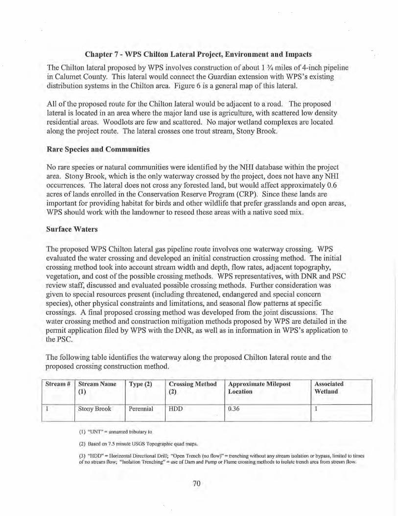
Chapter 7- WPS Chilton Lateral Project, Environment and Impacts
The Chilton lateral proposed by WPS involves construction of about 1 'l4 miles of 4-inch pipeline in Calumet County. This lateral would cmmect the Guardian extension with WPS's existing distribution systems in the Chilton area. Figure 6 is a general map of this lateral.
All of the proposed route for the Chilton lateral would be adjacent to a road. The proposed lateral is located in an area where the major land use is agriculture, with scattered low density residential areas. Woodlots are few and scattered. No major wetland complexes are located along the project route. The lateral crosses one trout stream, Stony Brook.
Rare Species and Communities
No rare species or natural communities were identified by the NHI database within the project area. Stony Brook, which is the only waterway crossed by the project, does not have any NHI occurrences. The lateral does not cross any forested land, but would affect approximately 0.6 acres of lands enrolled in the Conservation Reserve Program (CRP). Since these lands are important for providing habitat for birds and other wildlife that prefer grasslands and open areas, WPS should work with the landowner to reseed these areas with a native seed mix.
Surface Waters
The proposed WPS Chilton lateral gas pipeline route involves one waterway crossing. WPS evaluated the water crossing and developed an initial construction crossing method. The initial crossing method took into account stream width and depth, flow rates, adjacent topography, vegetation, and cost of the possible crossing methods. WPS representatives, with DNR and PSC review staff, discussed and evaluated possible crossing methods. Further consideration was given to special resources present (including threatened, endangered and special concern species), other physical constraints and limitations, and seasonal flow patterns at specific crossings. A final proposed crossing method was developed from the joint discussions. The water crossing method and construction mitigation methods proposed by WPS are detailed in the petmit application filed by WPS with the DNR, as well as in information in WPS's application to the PSC.
The following table identifies the waterway along the proposed Chilton lateral route and the proposed crossing construction method.
Stream#
1
Stream Name Type (2) Crossing Method Approximate Milepost Associated (1) (2) Location Wetland
Stony Brook Perennial HDD 0.36 1
(I) "UNT" =unnamed tributary to
(2) Based on 7.5 minute USGS Topographic quad maps.
(3) "HDD" =Horizontal Directional Drill; "Open Trench (no flow)"= h·enching without any stream isolation or bypass, limited to times of no stream flow; "Isolation Trenching"= use of Dam and Pump or Flume crossing methods to isolate trench area from stream flow.
70

Stony Brook is a designated a Class III trout water. The DNR reviews proposals affecting trout waters to ensure that the project would not directly affect spawning activity, or clitical habitat such as spawning beds, pools, or tiffles. There are no rare species occurrences recorded for Stony Brook near the proposed crossing location.
WPS proposes to install the pipeline across Stony Brook using the HDD method. No changes to the bed of this waterway or its water quality are expected to result from the pipeline installation if the HDD crossing method is successful.
Wetlands
The proposed WPS Chilton lateral gas pipeline route intersects 2 wetlands, of which one would not be impacted because the pipe would be directionally dlilled under it. The construction footplint in wetlands would be 75 feet: 50 feet of permanent easement, and 25 feet oftemporary construction easement. The total area of wetlands within the construction zone is 1.2 acres of emergent wetland.
Impacts to the trenched wetland would include an approximate 6-foot wide trench and a 35-foot wide spoil pile adjacent to the trench.
The following table identifies the wetlands along the proposed Chilton lateral route and the proposed crossing construction method for each.
Wetland Wetland Type Crossing Method * Approximate Associated
# Milepost Location Stream
1 Deciduous forested HDD 1 1
2 Wet meadow Open Trench 1
* "HDD" =Horizontal Directional Drill
Wetland 1 of the proposed Chilton lateral is associated with an Area of Special Natural Resource Interest, based on a classification of the Stony Brook as a trout stream. The potential impact on the waterway and adjacent wetlands should be minimal, due to the proposed use ofHDD construction method. The HDD installation of the pipeline would not directly disturb the surface of the stream or wetland.
Both wetlands contain wet meadows and are dominated by or contain reed canary grass. The likelihood of reed canary grass remaining dominant following construction is high.
No other wetland areas were identified through which construction of the proposed Chilton lateral would result in any unusual or major impacts to the wetlands.
71

Historic Resources
No known archeological or other historic resources were identified in the records of the WHS that appear to be at risk from construction of the proposed Chilton lateral pipeline.
72

Chapter 8 - WPS Denmark Lateral Project, Environment and Impacts
The Denmark lateral, proposed by WPS, would install about 14 miles of 12-inch pipeline in Brown County, connecting the Guardian extension with WPS's existing distribution systems in the Denmark area. Figure 7 is a general map of this lateral.
All of the proposed route for the Denmark lateral would be adjacent to existing linear features, roads for about 1 % miles and existing gas pipelines, owned by ANR Pipeline Company, for the remaining 12 Yz miles.
The proposed lateral crosses an area dominated by agriculture, with scattered low density residential areas. Woodlots are few and scattered. No major wetland complexes are located along the project route. The route crosses the edge of the Niagara Escarpment, within an area of relatively gentle, cleared slopes. None of the steep, forested cliffs that suppoti the escarpment's unique natural communities would be affected by the proposed lateral.
Rare Species And Communities
Some rare plant and animal species, but no natural community occurrences, were recorded in the area ofthe Denmark lateral. The natural habitat that is present is primarily dry to mesic southern forests associated with the East River and its tributaries. No CRP parcels or forested lands would be affected by this lateral.
One special concern fish species may be present in the East River and the Branch River : the redside dace (Clinostomus elongatus), along with one state-threatened fish species, the greater redhorse (Moxostoma valenciennesi). The redside dace prefers cool water pools and quiet riffles of small streams (usually adjacent to meadows or pastures) with substrate of cobble, sand, clay silt or bedrock. Spawning for this species occurs from May to early June. The greater redhorse prefers clear water of medium to large rivers, over bottoms of sand, gravel, or boulders. Spawning for this species occurs in May or June.
The reach where the Branch River is crossed is surrounded by agriculh1rallands and has very little riparian vegetation. Thus, it is unlikely that these fish species would be present or affected by the project. The East River would be directionally bored and there should not be any direct impacts to fish habitat unless a frac-out occurs. If this happened, WPS would implement contingency measures to respond to the release of drill mud.
Invertebrates
Two state-listed and three special concern snail species may be found within the project area. Four of these species prefer algific (cold producing) habitat or the similar cool, moist, shaded sites in deciduous forests of cliffs and talus slopes where algific conditions occur. The fifth species may prefer drier sites in upland woods and prairies. All of the recorded occurrences of these species have been associated with the Niagara Escarpment. The lateral route crosses the Escarpment adjacent to an existing utility corridor, with a gentle slope, and no bedrock outcrops.
73

The vegetation cover in this area does not create the moist and/or shaded conditions required by the snail species.
Birds
The bald eagle (Haliaeetus leucocephalus), a state special concern and federally-listed threatened species, has a nest occurrence near the project area; however, the project activities would not occur within the critical zone of the nest occurrence. Therefore, impact to this species is very unlikely. However, WPSC should reconfirm this determination with the DNR when 2007 monitoring data is available at the end of the year.
Plants
Only one historical occurrence of the American gromwell (Lithospermum latifolium), a plant of special concern in Wisconsin, has been recorded in the project area. This species prefers upland hardwood forests, often with dolomite near the surface. Land use along the pmiion of the route that crosses the escarpment is agricultural, with some riparian woodland and therefore is unsuitable for this species.
Niagara Escarpment
The Niagara Escarpment is a prominent geologic feature in eastern Wisconsin. The Niagara Formation is an extensive bedrock layer with edges that form a ridge curving westward from south ofRochester, New York, across southeast Canada, and then southward around the western side of Lake Michigan to southeastern Wisconsin. The formation is typically covered by up to several hundred feet of unconsolidated glacial till along its length with isolated, vertical outcrops and horizontal exposures. The exposed faces of the escarpment provide habitat for many rare species and communities. Of the proposed pipeline projects, only the WPS Denmark lateral crosses near the exposed faces of the escarpment in Section 23 of the town of Shirley, Brown County. At this location, the escarpment is marked only by the change in altitude, from approximately 650 to 800 feet above sea level, within 1.5 miles between mileposts 2 and 3.5. There are no exposed faces of the escarpment at the specific crossing location of this lateral, and the land use across this segment is primarily farming, with remnants of natural vegetation persisting only at fence rows and stream crossings.
The Land Legacy Program is a part of a directive from the Natural Resources Board. This board has advised the DNR to identify places ctitical to meet Wisconsin's conservation and outdoor recreation needs over the next 50 years. Determining where protection efforts should be focused, which protection strategies would be most effective, and who might be involved, would require a more detailed evaluation by the DNR, involving local landowners, citizens, various non-profit organizations, businesses, governments, and others. The area of the Escarpment identified in the Land Legacy program runs from Door County to Dodge County and covers a considerable area in Wisconsin. The proposed route for the Denmark lateral would follow an existing ANR pipeline corridor across the Escarpment. The Escarpment, at the proposed crossing, is in area of relatively gentle, cleared slopes and not the steep forested cliffs generally associated with the escarpment.
74

The proposed Denmark lateral is not in an area typically associated with the escarpment and has been previously disturbed through agricultural, residential, and utility use. It is highly unlikely that the proposed 12-inch natural gas line that follows an existing underground pipeline corridor would have a negative impact on this area if it is ever considered for inclusion in the Land Legacy Program,
Surface Waters
The proposed WPS Denmark lateral gas pipeline route involves ten waterway crossings. WPS evaluated each water crossing and developed an initial construction crossing method for each. The initial crossing method took into account stream width and depth, flow rates, adjacent topography, vegetation, and cost of the possible crossing methods. WPS representatives later visited some crossing locations with DNR and PSC review staff to further evaluate possible crossing methods. Further consideration was given to special resources present (including threatened, endangered and special concern species), other physical constraints and limitations (such as concrete bridge footings), and seasonal flow patterns at specific crossings. A final set of proposed crossing methods was developed from the joint discussions. The water crossing methods and construction mitigation methods proposed by WPS are detailed in the permit application filed by WPS with the DNR, as well as in information in WPS's application to the PS.C.
The following table identifies the waterways along the proposed Denmark lateral route and the proposed crossing construction method for each.
Stream# Stream Name (1) Type (2) Crossing Method (3) Approximate Associated
1 2 3 4
5 6 7 8 9
10
Milepost Location Wetland
East River Perennial HDD 0 East River Perennial HDD 0 East River Perennial HDD 1 1 UNT East River Perennial Trench w/Isolation 1
UNT East River Perennial Trench w/lsolation 1 2 UNT East River Perennial Trench w/Isolation 3 4 UNT East River Perennial Trench w/Isolation 3 4 UNT Branch River Perennial Trench w/Isolation 5 UNT Devils River Intermittent Open Trench (no 12 7
flow) UNT Devils River Intermittent Open Trench (no 12 8
flow)
(I) "UNT" =unnamed tributary to
(2) Based on 7.5 minute USGS Topographic quad maps.
(3) "HDD" = Horizontal Directional Drill; "Open Trench (no flow)"= h·enching without any stream isolation or bypass, limited to times of no sh·eam flow; "Isolation Trenching"= use of Dam and Pump or Flume crossing methods to isolate trench area from stream flow.
75

None of the waterways that would be crossed by the proposed Denmark lateral are classified as trout streams, nor are any classified as Outstanding or Exceptional Resource Waters.
The largest waterway along the Denmark lateral route is the East River, which traverses agricultural and urban lands. The water is hard and turbid with many tributaries entering it from the east off of the Niagara Escarpment. It is considered a warm-water forage fishery. The water quality is directly related to the amount of nutrient and stormwater inputs from agricultural practices. The proposed pipeline route crosses a meandering section of the river, where three crossings occur over a short distance. A single, long HDD installation is proposed for the East River, spanning all three crossing locations. No changes to the bed ofthe East River or its water quality would result from pipeline installation if the HDD crossing method is used.
The evaluation of potential impacts from crossing watetways using any of the following open trench methods assumes that the DNR waterway permit would require use of appropriate ·erosion control practices, along with restoration of the streambed contours to preconstruction conditions.
Conventional open cut trench construction is proposed for crossing two intermittent waterways if there is no flow at time of construction. Both are unnamed tributaries to the Devils River and have no flowing water during portions of the year. Crossing these intermittent streams during no-flow periods with open cut trenching would not be expected to alter the streams' water quality, streambed configuration, or flow characteristics. WPS has stated that if there is water flowing at the time of construction, WPS would install a temporary sandbag cofferdam and would pump the stream water around the work area or the stream would be directionally drilled.
The other five waterways along the route of the Denmark lateral are small, shallow, perennial streams. Four are tributaries to the East River and the fifth is a tlibutary to the Branch River. A dam and pump or a dam and flume construction method would be used for these five waterways. No unusual resources were identified at any ofthese five crossing locations. As noted in the overall discussion of potential waterway crossing impacts in Chapter 2, the use of a dam and pump or a dam and flume construction method at these crossings should result in only minor, temporary impacts to the water quality of these streams.
Wetlands
The proposed WPS Denmark lateral gas pipeline route involves ten wetland crossings. The construction footprint in wetlands would be 75 feet, with 50 feet of permanent easement and 25 feet of temporary construction easement. The total area of wetlands within the construction zone is 1.3 acres (0.8 acres forested and 0.5 acres emergent) . Construction through two of the ten wetlands, totaling 107 feet, would use HDD installation and therefore would not directly affect the surface of the wetlands.
The following table identifies the wetlands along the proposed Denmark lateral route and the proposed crossing construction method for each.
Wetland Wetland Type Crossing Method * Approximate Associated
# Milepost Location Stream
1 Deciduous forested HDD 1
76

2 Deciduous forested Open Trench 2 3 Wet meadow Open Trench 3 1 4 Wet meadow Open Trench 4
5 Wet meadow Avoided 4 2 6 Wet meadow Open Trench 10 4 7 Wet meadow Open Trench 12 4 8 Wet meadow Open Trench 12 9 Deciduous forested HDD 14 7 10 Wet meadow Open Trench 14 7 11 Wet meadow Open Trench 14 8
* "HDD" =Horizontal Directional Drill
Most of the wet meadow wetlands along the project route are infested, or dominated by, reed canary grass. It is highly likely that reed canary grass will remain dominant following construction unless active management is applied. Wetlands 1 and 9 would not be directly impacted during the installation of the line, however, these wetlands would be affected by clearing trees from the ROW. Some of the currently tree covered area would be kept permanently clear to allow access and inspection of the pipeline. This would change the wetlands' functional values.
Six of the wetlands that would be crossed by the proposed Denmark lateral are classified as Areas of Special Natural Resource Interest, based on a classification ofwetlands adjacent to slopes of greater than 12%, used by Brown County Planning Department. The use of appropriate erosion control practices on the slope areas of these wetlands should provide reasonable protection for the wetlands. None of the wetland areas that would be crossed by this lateral would suffer any unusual or major impacts.
Historic Resources
No known archeological or other historic resources that appear to be at risk from construction of the proposed Denmark lateral pipeline were identified in the WHS records.
77
Chapter 9- WPS Southwest Green Bay Lateral Project, Environment and Impacts
The Southwest Green Bay lateral proposed by WPS involves construction of about 8 miles of 20-and 12-inch pipeline in Brown County. This lateral would connect Guardian's extension to existing distribution systems in and around the Green Bay metropolitan area. Figure 8 shows the route proposed.
The proposed project route crosses from agricultural lands into an urban area. The first section ofthis lateral, about 1.2 miles in length, would be adjacent to railroad and electric transmission line ROWs passing through agricultural lands that are being convetied to an industrial park use. The remainder of the proposed route would be located within city streets. The primary land cover along the proposed route is urban, crossing through both commercial and residential areas. Woodlands, wetlands, and other natural land cover remains in only small and scattered patches.
Rare Species and Communities
This lateral traverses a highly developed landscape, and the longest undeveloped segment, from MP 1.0 to MP 2.0, would parallel a proposed road extension. The NHI database identified one state-listed turtle species, one state-listed fish species and seven special concern species within the project area .
Fish and turtles
The only waterway the project crosses is Ashwaubenon Creek, which is unlikely to support habitat for two of the three aquatic species, the lake sturgeon (Acipenser fulvescens) (state special-concern) and American eel (Anguilla rostrata) (special concern). A third species, the longear sunfish (Lepomis megalotis) (state threatened) is recorded in an adjacent waterway that would not be affected by the project. Ashwaubenon Creek is being directionally bored, and therefore, the risk to this species is low, should it actually occur there.
Ashwaubenon Creek also supports the wood turtle (Clemmys insculpta) (state-threatened); however, this segment of the ROW is bordered on one side by a city street and the entire segment would be bored. Therefore, while the habitat may be low to moderately suitable, it would not be affected by construction activities and therefore, the species, if present, is unlikely to be affected.
Invertebrates
Two special concern butterfly species may be present in the project area. Both species prefer upland areas, which may be present along undisturbed corridors like railroads or fencerows. However, the lateral route was shifted to avoid these habitat areas, therefore, impact to these species is unlikely.
78

Birds
The bald eagle (Haliaeetus leucocephalus) , a state special concern and federally listed threatened species, has a nest occurrence in the project area; however, the project activities would not occur within the critical zone of the nest occmrence. Therefore, impact to this species is very unlikely. However, WPS should reconfirm this dete1mination with the DNR when 2007 monitoring data is available at the end of the year.
The dickcissel (Spiza americana), a state special concern species, may be present in the project area. This species prefers open pasture, old fields and fields of clover and alfalfa. The breeding/nesting season for this bird extends from late May to mid-August. The segment from MP 0.0 to MP 2.0 was evaluated for suitable habitat for this species, but was discarded because of it's relatively small and actively disturbed by row crops.
Surface Waters
The proposed WPS Southwest Green Bay lateral gas pipeline route involves one waterway crossing. WPS evaluated the waterway crossing and developed an initial construction crossing method. The initial crossing method took into account stream width and depth, flow rates, adjacent topography, vegetation, and cost of the possible crossing methods. WPS representatives later visited the crossing location with DNR and PSC review staff to further evaluate possible crossing methods. Further consideration was given to special resources present (including threatened, endangered and special concern species), other physical constraints and limitations (such as concrete bridge footings), and seasonal flow patterns at specific crossings. A final proposed crossing method was developed from the joint discussions between WPS, DNR and PSC representatives. The water crossing method and construction mitigation method proposed by WPS are detailed in the permit application filed by WPS with the DNR, as well as in information in WPS's application to the PSC.
The following table identifies the waterway along the proposed Southwest Green Bay lateral route and the proposed crossing construction method.
Stream# Stream Name (1) Type (2) Crossing Method (3) Approximate Associated
1 Milepost Location Wetland .
Ashwaubenon Perennial HDD 7 1 and 2 Creek
(I) "UNT" = unnamed tributary to
(2) Based on 7.5 minute USGS Topographic quad maps.
(3) "HDD" =Horizontal Directional Drill ; "Open Trench (no flow)" = trenching without any stream isolation or bypass, limited to times of no stream flow; "Isolation Trenching"= use of Dam and Pump or Flume crossing methods to isolate trench area from stream flow.
This waterway is not classified as a trout stream, nor is it classified as Outstanding or Exceptional Resource Water. Ashwaubenon Creek is a sluggish, turbid, hard water stream flowing through agricultural and residential Brown County. The bottom materials consist of rubble, gravel and silt. The banks in the agricultural areas are bare. It is considered a warm
79

water forage fishery with little fishelies value. The water quality is directly related to the amount of nutlient and storm water inputs from agricultural practices. A single, long holizontal directional dlill (HDD) installation is proposed for the waterway, which is located at the bottom of a steeply sided ravine. No changes to the bed of the Ashwaubenon Creek or its water quality would result from pipeline installation if the HDD crossing method is used.
The evaluation of potential impacts from crossing the waterway using the HDD method assumes that the DNR stormwater permit would require use of appropliate erosion control practices along with the restoration of the upper stream bank contours to preconstruction conditions.
Wetlands
The proposed WPS Southwest Green Bay lateral gas pipeline route crosses two wetlands that would not be impacted because the pipe would be directionally bored under them. The total area of wetlands within the permanent easement is 0.2 acres. Both are scrub/shrub wetlands.
The following table identifies the wetlands along the proposed Southwest Green Bay lateral route and the proposed crossing construction method for each.
Wetland Wetland Type Crossing Method * Approximate Associated
# Milepost Location Stream
1 Scmb/shmb HDD 7 1 2 Scmb/sluub HDD 7 1
* "HOD"= Horizontal Directional Drill
The two wetlands would not be directly impacted by the installation of the pipe, however, the wetlands would be impacted by cleating shrubs from the ROW. Some of the area currently supporting shrubs would need to be kept permanently clear to allow access and inspection of the pipeline. This would change the wetland's functional values.
Both wetlands are classified as Areas of Special Natural Resource Interest, based on a classification of wetlands adjacent to slopes of greater than 12%, used by Brown County Planning Department. The use of appropliate erosion control practices on the slope areas of these wetlands should provide reasonable protection for the wetlands.
No wetland areas were identified through which construction of the proposed Southwest Green Bay lateral would result in any unusual or major impacts to the wetlands.
Historic Resources
No known archeological or other historic resources that appear to be at lisk from construction of the proposed Southwest Green Bay lateral pipeline were identified in the WHS records.
80

.Chapter 10- Summary of Projects and Impacts
Proposed Projects
Guardian Pipeline LLC owns and operates an existing high-capacity natural gas line extending from the Chicago area northward to near Ixonia in Jefferson County. Guardian's interstate pipeline system transports natural gas supplies into Wisconsin for delivery into the distribution systems of local gas utilities, who in tum deliver the gas to retail customers. Guardian proposes to extend its natural gas transmission pipeline from Ixonia into the Green Bay area by installing about 119 miles of new pipeline. Guardian also proposes to construct two new compressor stations, the first in northern Walworth County and the second in northern Illinois.
WG, WE, and WPS are proposing to connect their existing gas distribution systems to the Guardian pipeline extension at seven locations, six of which would require the construction of several new gas lateral pipelines.
Regulatory Authority
To construct the pipelines described in this EA, Guardian WG, WE and WPS must receive several major regulatory approvals .. These include a FERC CPCN for the mainline, and construction authorizations from the PSC for the laterals. All of those companies must receive permits and approvals from the DNR imd U.S. Army Corps of Engineers (USACE) for construction across waterways and wetlands.
Facilities and their Potential Impacts
To allow construction of the pipelines, the applicants would acquire an easement that would allow enough space to operate the construction equipment and allow space for soil piles, etc. Following construction, a permanent easement centered along the pipeline would be retained to protect against excavations near the pipe and to allow access for maintenance and repair. The permanent easement is usually considerably narrower than the construction easement. Portions of the proposed lateral projects would occur within the ROWs of existing roads. In these situations, authorizations to work in and occupy parts of the right-of-way are usually granted to the applicant, rather than the acquisition of an easement.
The large range of pipe sizes being proposed for Guardian and the laterals does not allow a simple characterization of the construction work space needed. In general, however, a construction easement of between 100 and 125 feet wide is typical where construction occurs on private easements. In wetlands and wooded areas, the construction work space is usually narrowed to a width of about 75 feet. About 50 feet of the construction work space would remain in permanent easement.
The proposed Guardian mainline and the Hartford!W est Bend, Sheboygan, Chilton, and Denmark laterals are located in areas where the major land use is agriculture, with scattered lowdensity residential areas. The Sheboygan lateral would cross the Kettle Moraine State Forest; but, it would be located within an existing electric transmission line ROW through the state
81
forest. Other woodlots along these four laterals are few and scattered. Each lateral would also cross a number of waterways and scattered wetlands.
The Fox Valley and Southwest Green Bay laterals both extend from agricultural lands into actively expanding urban areas. Residential and commercial developments are the dominant land uses as these routes enter urban areas. Only small, isolated wetland and forest resources are present along these two routes.
Construction of the proposed combined mainline/lateral projects would require approximately 1 79 waterway crossings, including 114 by the Guardian mainline, 13 by the Hartford/West Bend lateral, up to 17 by the Fox Valley lateral, 21 by the Sheboygan lateral, one by the Chilton lateral, 10 by the Denmark lateral and one by the Southwest Green Bay lateral.
Approximately 122 of the waterway crossings are intermittent streams, with periods of the year where no water flow occurs. DNR permit staff has indicated that open cut trench construction would be allowed to cross these intermittent waterways only at times of no flow. Crossing the intermittent streams during no-flow periods with open cut trenching would not alter the streams' water quality or have any direct affect on aquatic life. With simple restoration efforts, there would also not be any substantial change to streambed configuration or flow characteristics as a result of open trenching of intermittent streams under no-flow conditions.
The remaining 57 crossings are perennial waterways with year-round flow. Included in the perennial crossings are one state Exceptional Resource Water, two federal Section 10 Waterways, and six state-designated trout streams. The potential environmental consequences to the waterways that would be crossed using horizontal directional drilling or jack and bore pipeline construction method would be minimal, due to the fact that those pipeline installation methods do not directly disturb the bed or water column of the waterway. The potential impacts to the perennial waterways that would be crossed using a dam and pump or flume method, are also expected to be minor, with impacts primarily related to preventing or restricting the movement of fish and other aquatic organisms through the construction zone.
About 63 acres of wetland would be impacted during construction of the proposed Guardian mainline and the six lateral pipeline projects together would affected about 40 acres, for an overall total of about 103 acres of affected wetland. Most of the potential impacts to wetlands are temporary in duration, with no substantial long-term impacts anticipated.
Construction activities in wetlands generally involve ROW and workspace clearing, erosion control installation, topsoil stripping, trench excavation and pipe stringing, pipe installation and backfilling, and site restoration.
The potential impacts to wetlands include both pe1manent and temporary components. Permanent impacts include the actual placement of pipeline in the wetland and the clearing of trees and shrubs necessary to maintain the pipeline ROW. This wooded wetland clearing would change the nature of the wetland habitat and its functional values.
82

Temporary impacts of pipeline construction through wetlands include: compaction of soils and alterations of important microtopography within the wetland that could potentially alter the hydrology; changes to plant composition including the introduction of invasive species; and soil mixing within the excavated areas.
Impacts to wetlands and streams would be minimized and mitigated through various measures proposed by the company and additional measures that will be specified in DNR and U.S. Army Corps of Engineers permits. No permits would be issued for activities that do not meet the NR 103 Wetland Water Quality Standards provisions, or the requirements ofDNR Chapter 30 waterway permits. Meeting these standards helps to ensure that impacts are avoided and minimized.
About 52 acres of forest land would be directly affected by construction ofthe Guardian mainline and about 20 acres of forest would be affected by construction of the six lateral pipelines. The combined total would be about 72 acres of forest lands. These numbers represent the area that would be cleared of all trees in the construction work space.
The removal of the tree cover is a substantial change to the plant and animal communities in the areas cleared. This change would be permanent for much of the area cleared. No extensive individual wooded areas would be cleared of trees. ·The amount oftree clearing needed for any specific wooded area is small, consistent with the highly fragmented and developed nature of the landscape in the project area.
One of the lateral projects, the WPS Sheboygan lateral, would cross an area with extensive forest lands, the Kettle Moraine State Forest. The proposed route through the Kettle Moraine, however, would locate the pipeline within an already cleared ROW for a high-voltage electric transmission line. Limited additional tree clearing may be necessary in this area.
There are several state or federal rare species known to occur near or within the counties traversed by the proposed Guardian mainline project. Several of these species require habitat conditions that are not present along the pipeline construction route, e.g., alkaline wetlands, algific cliffs, etc. Guardian has completed surveys for some of the remaining species and would complete the remainder of the surveys prior to construction in spring 2007. Both the FWS and DNR have established measures to avoid or minimize impacts to those species such that significant impact to any of these species is unlikely.
Because the routes of the proposed lateral projects pass through landscapes dominated by agriculture and urban areas, they do not have many rare species occurrences. The route for the WPS Sheboygan lateral passes through the Kettle Moraine, an area with large tracts of relatively undisturbed lands and that suppmi many rare species. The proposed gas pipeline through the Kettle Moraine, however, would be located within an existing electric transmission line ROW, which reduces its potential to affect rare plants and animals. The route for the WPS Denmark lateral crosses the edge of the Niagara Escarpment, but does so in an area of relatively gentle, cleared slopes. None of the steep, forested cliffs that give the escarpment its unique qualities, and provides habitat for many rare species, would be affected by construction of the proposed
83

lateral. Overall, no appreciable negative impact on the long-term survival of existing populations of rare species is expected.
Construction of large pipelines can damage or reduce the suitability of lands for agricultural use. Potential impacts included soil compaction, mixing of soil layers, disrupting drainage patterns, and increasing the density ofrocks near the surface of the soil. These impacts can lead to reduced crop productivity or damage to farm equipment.
When constructing the proposed pipelines through agricultural lands, Guardian, WG, WE, and WPS have all proposed to use construction practices to help address these issues. The proposed construction practices are based on experience with past pipeline construction projects. The proposed practices include: methods to segregate topsoil and subsoils; practices for stabilizing exposed soils to reduce runoff and erosion of silts and sediments; methods to locate, protect, and repair any soil drainage systems crossed by the pipeline projects; soil restoration methods to eliminate compaction and to reduce the increase of rock near the soil surface; and seeding methods, where appropriate. Implementing the proposed agricultural construction practices should greatly reduce or eliminate the major impacts associated with construction through farmlands.
Construction equipment used to install the pipelines would produce air pollutant emissions. In addition, there is a potential for periodic short-duration emissions resulting from operation of the emergency generator that would be located at Guardian's Bluff Creek compressor station in Walworth County. Neither source of emissions would be expected to result in any significant degradation of air quality in the project area.
The construction of the proposed gas pipelines could also create a nuisance disturbance. Noise and vibrations generated from construction equipment could be bothersome. These effects would generally be short-term and would end when construction is complete.
84
Chapter 11 - Alternatives
Alternatives to the pipeline projects under consideration, as well as alternative routes for those pipelines, are discussed in detail in the FERC EIS (Chapter 3) and the PSC EA. The DNR has three alternative courses of action in processing the applications for the water crossing permits and wetland water quality certifications. It may approve the requested permits and certifications, conditionally approve, or deny. This determination is based on the standards set by state law and regulations. If the standards can be met then the permits and certifications must be granted. The DNR is not aware of conditions that would prevent approval. The conditions included in the permits would cover details such as the timing of construction, approved methods and restoration requirements.
If the Guardian expansion project is denied by the FERC, it is still possible that another proposal to expand interstate pipeline capacity into northeastern Wisconsin might be developed in the near future. The overall environmental impacts associated with such a new pipeline project would likely be similar to that of the current proposed Guardian expansion and associated laterals. The site-specific impacts, however, may be different and would depend on the specific facilities and routes proposed. There is no accurate way to predict the likelihood of such a new interstate pipeline project being proposed, to predict the size and number of associated lateral pipelines, or to predict the routes that would be proposed. The environmental impacts of new utility laterals to connect to a different interstate pipeline expansion could be greater, lesser, or the same as the environmental impacts associated with the current proposed projects.
During its initial siting process in early 2004, Guardian evaluated three potential pipeline routes. The three routes considered were an eastern route, a central route, and a western route. These alternatives are discussed in the FERC EIS in Section 3.3 beginning on page 3-8. Guardian sought input from interested parties, and local, state, and federal government officials, regarding pipeline siting. The proposed route is a variation of the central route, which was selected to avoid impacts to sensitive environmental resources where possible. Where it is not possible to avoid environmental resources, Guardian's construction plans will minimize impacts. The FERC EIS is available online at the following website:
http:/ /www.ferc. govlindustries/ gas/enviro/eis/2007 /04-13-07 -guardian. asp.
Since release of the FERC Draft EIS, Guardian adopted a route change that avoids crossing tribal lands within the Oneida Reservation. The route change was incorporated because of the potential risk that Guardian would not be able to secure an easement to build the pipeline within the timeframe required by Guardian's customers. The Brown and Outagamie County portion of the line has been re-routed from just after its proposed crossing of the Fox River to avoid crossing Oneida Reservation lands. Guardian has made a supplemental filing to FERC for the branch lines and the Fox River South Variation.
85
Chapter 12- Evaluation
Primary and secondary environmental effects
The construction of the proposed pipeline projects would result in short-term, localized increases in noise, vibrations, air quality degradation, odors, erosion and run-off, all of which are expected to be minor. Most of the primary environmental effects of the proposed projects are short-term, localized effects from construction activities. No long-term primary environmental effects are expected, with the exception of the permanent clearing of trees in some potiions of the proposed routes. Establishment of utility ROW's does increase the potential for additional utilities to be constructed along those ROW's in the future. The proposed projects will suppoti development in the affected areas.
Effects on geographically important or scarce resources
No geographically important or scarce resources within the project area are expected to be significantly affected by construction of the proposed pipeline projects. The portion of the Sheboygan lateral route that passes through the Kettle Moraine State Forest is located within an existing disturbed transmission line ROW.
Reversibility of environmental effects
If the Guardian expansion and the lateral pipelines are installed, the effects associated with the long-term presence of the pipelines would be irreversible. This is because pipelines are generally abandoned in place, rather than being removed, when they are no longer useful. However, the ROW could revert to its original vegetative cover if the pipelines were ever abandoned.
Significance of cumulative effects
The proposed projects are common construction activities of natural gas utilities, even though the combined length of the multiple proposed projects is longer than most projects. Many gas utility projects are constructed in already disturbed and extensively maintained road ROWs where the potential environmental effects are generally minor. The proposed pipeline projects, however, would primarily be constructed on new easements on private propetiy which is extensively used for agriculture. The overall cumulative effect of repeated actions of the type proposed is considered minor, but each project has been screened for the presence of unusual resources or circumstances. None of the individual or combined impacts on these types of resources is expected to be significant.
Significance of unknowns that create substantial uncertainty in predicting environmental effects
None known. The environmental effects of pipeline construction are well-known.
86

Significance of reasonably anticipated operating problems
Although natural gas pipelines are constructed with many safeguards and monitoring systems to prevent ruptures, it is not possible to completely eliminate the risk of potential ruptures and accidental damage from other excavations. The FERC EIS discusses operation and maintenance issues in section 2.6 beginning on page 2-26. The FERC EIS is available online at the following website:
http://www .ferc. gov /industries/ gas/ enviro/ eis/2007 /04-13-07-guardian. asp.
Significance of precedent
The proposed pipeline projects would not set any precedents. The proposed projects would not result in any new environmental effects. The construction of large-diameter natural gas pipelines is a common activity of Wisconsin gas utilities. The multiple projects, and their combined length, however, exceeds that of most recent individual gas utility construction projects.
Significance of controversy
There is no known controversy regarding the type, magnitude or significance of the expected environmental impacts of the proposed lateral pipeline projects.
Conflicts with federal, state or local plans or policies
There are no known conflicts of the proposed actions with any federal, state or local plans or policies. Staff of the Kettle Moraine State Forest indicated that the proposed gas lateral would not affect protection or management of the natural resources present in the state forest.
87

Project Name: Guardian Interstate Natural Gas Pipeline Extension and Lateral Pipelines Counties: Jefferson, Dodge, Fond du Lac, Calumet, Outagamie, Brown , Washington, and Sheboygan
DECISION (This decision is not final until certified by the appropriate authority)
In accordance with s. 1.11, Slats. , and Ch. NR 150, Adm. Code, the Department is authorized and required to determine whether it has complied with s.1 .11, Slats ., and Ch. NR 150, Wis. Adm. Code.
Complete either A or B below:
A.EIS Process Not Required
The attached analysis of the expected impacts of this proposal is of sufficient scope and detail to conclude that this is not a major action which would significantly affect the quality of the human environment. In my opinion , therefore, an environmental impact statement is not required prior to final action by the 'Department.
B.Major Action Requiring the Full EIS Process D The proposal is of such magnitude and complexity with such considerable and important impacts on the quality of the human environment that it constitutes a major action significantly affecting the quality of the human environment.
Date Signed
Number of responses to news release or other notice: ?
Certified to be in compliance with WEPA Environmental Analysis Program Staff Date Signed
~~~ 0 7 / :<.6/;2.o::J 7
~
NOTICE OF APPEAL RIGHTS
If you believe you have a right to challenge this decision made by the Department, you should know that Wisconsin statutes, administrative codes and case law establish time periods and requirements for reviewing Department decisions.
To seek judicial review of the Department's decision, ss . 227.52 and 227.53, Slats., establish criteria for filing a petition for judicial review. Such a petition shall be filed with the appropriate circuit court and shall be served on the Department. The petition shall name the Department of Natural Resources as the respondent.
88