gulf coast vulnerability assessment
TRANSCRIPT

GULF COAST VULNERABILITY ASSESSMENT: Mangrove, Tidal Emergent Marsh,
Barrier Islands and Oyster Reef
RESEARCH BULLETIN
GULF COAST VULNERABILITY ASSESSMENT: Mangrove, Tidal Emergent Marsh, Barrier Islands, and Oyster Reef
The Forest and Wildlife Research Center (FWRC) at Mississippi State University (MSU) was established by the Mississippi Legislature with the passage of the Renewable Natural Resources Research Act of 1994. FWRC's mission is to conduct research and technical assistance programs relevant to the efficient management and utilization of the forest, wildlife, and fisheries of the state and region, and the protection and enhancement of the natural environment associated with these resources. FWRC scientists conduct research in laboratories and forests administered by the university and cooperating agencies and industries throughout the country. Research results are made available to potential users through the university’s educational program and through FWRC publications such as this, which are directed as appropriate to forest landowners and managers, forest products manufacturers and consumers, government and industry leaders, the scientific community, and the general public. Dr. George M. Hopper is director of the Forest and Wildlife Research Center.
Authors
This was a team effort led to completion by a Core Planning Team coordinated by Amanda Watson. Ecosystem and Species Expert Teams were established for each of the four ecosystems evaluated: Mangrove work was led by Laura Geselbracht (The Nature Conservancy); Tidal Emergent Marsh by Mark Woodrey (Grand Bay NERR/Mississippi State University); Oyster Reef by Megan LaPeyre (U. S. Geological Survey/LSU Agricultural Center); and Barrier Islands by P. Soupy Dalyander (U. S. Geological Survey). Additional authors included Blair Tirpak (U. S. Geological Survey/Gulf Coast Prairie LCC), Joshua Reece (Valdosta State University), and Cynthia Kallio Edwards (Gulf Coast Prairie LCC). The Core Planning Team, Ecosystem and Species Expert Teams, and the individual assessors are collectively referred to as the Assessment Team throughout the document.
AcknowledgementThe GCVA was initiated by the four Landscape Conservation Cooperatives (LCCs) that cover the Gulf of Mexico: the Gulf Coast Prairie, Gulf Coastal Plains & Ozarks, South Atlantic, and Peninsular Florida LCCs. Each LCC is directed by a Steering Committee of partners that also provided support for this project. Additional support and guidance was provided through the National Oceanic and Atmospheric Administration (NOAA), the Northern Gulf Institute (NGI), the Louisiana Coastal Protection and Restoration Authority, and the United States Geological Survey (USGS) through the Southeast Climate Science Center. The Core Planning Team acknowledges Laurie Rounds of NOAA who led the initial effort on this project, and without whose vision we would not have this work completed today.
To Order CopiesCopies of this and other Forest and Wildlife Research Center publications are available from:
Publications OfficeForest and Wildlife Research CenterBox 9680Mississippi State, MS 39762-9680
Please indicate author(s), title and publication number if known.Publications are also available at the website at www.fwrc.msstate.edu
CitationWatson, A., J. Reece, B. E. Tirpak, C. K. Edwards, L. Geselbracht, M. Woodrey, M. K. La Peyre, and P. S. Dalyander. 2017. The Gulf Coast Vulnerability Assessment: Mangrove, Tidal Emergent Marsh, Barrier Islands, and Oyster Reef. Forest and Wildlife Research Center, Research Bulletin WFA421, Mississippi State University. 100 pp.
RESEARCH BULLETIN WFA421

GULF COAST VULNERABILITY ASSESSMENT: Mangrove, Tidal Emergent Marsh, Barrier Islands, and Oyster Reef
by
Amanda WatsonMississippi State University
Joshua ReeceValdosta State University
Blair E. TirpackU.S. Geological Survey
Cynthia Kallio EdwardsGulf Coast Prairie LCC
Laura GeselbrachtThe Nature Conservancy
Mark WoodreyMississippi State University
Megan K. La PeyreU.S. Geological Survey
P. Soupy DalyanderU.S. Geological Survey

iv | Forest and Wildlife Research Center | Mississippi State University
Abstract viiPreface VisionVulnerability Assessment JustificationMethodology for Conducting Vulnerability Assessments Project Goals and Objectives
1. INTRODUCTION 10 Need for an Assessment Study Area Description
Inland Terrestrial BoundarySeaward Boundaries
The Contemporary LandscapeEcosystemsGulf Coast ClimateCurrent Ecosystem Threats
The Human Aspects of the Gulf CoastEconomicsCulture
2. ECOSYSTEMS AND SPECIES ASSESSED 17 Mangrove
Roseate Spoonbill Tidal Emergent Marsh
Blue CrabClapper RailMottled DuckSpotted Seatrout
Oyster ReefEastern Oyster American OystercatcherRed Drum
Barrier IslandsBlack SkimmerKemp’s RidleyWilson’s Plover
3. METHODS 23 Timeframe Expert Engagement Standardized Index of Vulnerability and Value Assessment Supporting Information
Map Layers
TABLE OF CONTENTS

Gulf Coast Vulnerability Assessment: Mangrove, Tidal Emergent Marsh, Barrier Islands, and Oyster Reef | v
4. RESULTS: Ecosystem & Species Vulnerability 30 Mangrove
Roseate Spoonbill Tidal Emergent Marsh
Blue CrabClapper RailMottled DuckSpotted Sea trout
Oyster ReefEastern OysterAmerican OystercatcherRed Drum
Barrier IslandsBlack SkimmerKemp’s Ridley Sea TurtleWilson’s Plover
5. LESSONS LEARNED 48 Approach The SIVVA Tool Scale Data Species and Ecosystem Selection
6. UNCERTAINTIES OF POTENTIAL FUTURE RESEARCH 51
7. SETTING THE STAGE FOR ADAPTION 54 General Adaptation Strategies
Literature Cited 57
Appendix 68Appendix 1 – Module Scores for Each Ecosystem and SpeciesAppendix 2 – SIVVA CriteriaAppendix 3 – Engagement of ExpertsAppendix 4 – Climate DataAppendix 5 – Additional Climate Scenario GraphsAppendix 6 – Additional Assessor Variation GraphsAppendix 7 – Additional Ecosystems

vi | Forest and Wildlife Research Center | Mississippi State University
LIST OF FIGURES
Figure 1: GCVA Subregions ................................................................................................................................................................................................. 11Figure 2: NOAA Coastal Drainage Area and Estuarine Drainage Areas ...................................................................................................... 11Figure 3: Marine Ecoregions (Level III) ........................................................................................................................................................................ 12Figure 4: Number of Species and Ecosystem Assessments Completed by Subregion ................................................................... 23Figure 5: Emissions Levels and Temperature Increases ................................................................................................................................... 26Figure 6: Extent of SLAMM Coverage Used ..............................................................................................................................................................27Figure 7 Distribution of Average Ecosystem Vulnerability Scores................................................................................................................. 30Figure 8 Distribution of Average Species Vulnerability Scores ........................................................................................................................31Figure 9: Mean Vulnerability Scores .............................................................................................................................................................................. 31Figure 10: Vulnerability of Mangrove ........................................................................................................................................................................... 33Figure 11: Vulnerability of Roseate Spoonbill ........................................................................................................................................................... 34Figure 12: Vulnerability of Tidal Emergent Marsh ................................................................................................................................................ 35Figure 13: Vulnerability of Blue Crab ........................................................................................................................................................................... 36Figure 14: Vulnerability of Clapper Rail ...................................................................................................................................................................... 37Figure 15: Vulnerability of Mottled Duck ................................................................................................................................................................... 38Figure 16: Vulnerability of Spotted Seatrout.............................................................................................................................................................. 39Figure 17: Vulnerability of Oyster Reef ......................................................................................................................................................................... 40Figure 18: Vulnerability of Eastern Oyster ................................................................................................................................................................... 41Figure 19: Vulnerability of American Oystercatcher. ............................................................................................................................................. 42Figure 20: Vulnerability of Red Drum .......................................................................................................................................................................... 43Figure 21: Vulnerability of Barrier Islands ................................................................................................................................................................... 44Figure 22: Vulnerability of Black Skimmer ................................................................................................................................................................. 45Figure 23: Vulnerability of Kemp’s Ridley Sea Turtle ........................................................................................................................................... 46Figure 24: Vulnerability of Wilson’s Plover .................................................................................................................................................................47
LIST OF TABLES
Table 1: Modules Used to Calculate Vulnerability in SIVVA ............................................................................................................................. 24Table 2: Summary of Information Needs for Species ........................................................................................................................................... 51Table 3: Summary of Information Needs for Habitats ....................................................................................................................................... 52

Gulf Coast Vulnerability Assessment: Mangrove, Tidal Emergent Marsh, Barrier Islands, and Oyster Reef | vii
ABSTRACT
Climate, sea level rise, and urbanization are undergoing unprece-dented levels of combined change and are expected to have large effects on natural resources—particularly along the Gulf of Mexico coastline (Gulf Coast). Management decisions to address these effects (i.e., adaptation) require an understanding of the relative vulnerability of various resources to these stressors. To meet this need, the four Landscape Conservation Cooperatives along the Gulf partnered with the Gulf of Mexico Alliance to conduct this Gulf Coast Vulnerability Assessment (GCVA). Vulnerability in this context incorporates exposure and sensitivity to threats (poten-tial impact), coupled with the adaptive capacity to mitigate those threats. Potential impact and adaptive capacity reflect natural his-tory features of target species and ecosystems. The GCVA used an expert opinion approach to qualitatively assess the vulnerability of four ecosystems: mangrove, oyster reef, tidal emergent marsh, and barrier islands, and a suite of wildlife species that depend on them. More than 50 individuals participated in the completion of the GCVA, facilitated via Ecosystem and Species Expert Teams.
Of the species assessed, Kemp’s ridley sea turtle was identified as the most vulnerable species across the Gulf Coast. Experts identified the main threats as loss of nesting habitat to sea level
rise, erosion, and urbanization. Kemp’s ridley also had an overall low adaptive capacity score due to their low genetic diversity, and higher nest site fidelity as compared to other assessed species. Tidal emergent marsh was the most vulnerable ecosystem, due in part to sea level rise and erosion. In general, avian species were more vulnerable than fish because of nesting habitat loss to sea level rise, erosion, and potential increases in storm surge.
Assessors commonly indicated a lack of information regarding impacts due to projected changes in the disturbance regime, bi-otic interactions, and synergistic effects in both the species and habitat assessments. Many of the assessors who focused on species also identified data gaps regarding genetic information, phenotypic plasticity, life history, and species responses to past climate change and sea level rise. Regardless of information gaps, the results from the GCVA can be used to inform Gulf-wide adap-tation plans. Given the scale of climatic impacts, coordinated ef-forts to address Gulf-wide threats to species and ecosystems will enhance the effectiveness of management actions and also have the potential to maximize the efficacy of limited funding.
viii | Forest and Wildlife Research Center | Mississippi State University
The Gulf Coast Vulnerability Assessment (GCVA or “Assessment”) is a collaborative effort to evaluate the vulnerability of four key ecosystems and eleven associated species across the U.S. portion of the Gulf of Mexico. The Core Planning Team, Ecosystem and Species Expert Teams, and the individual assessors are collectively referred to as the Assessment Team throughout the document.
Assessing vulnerability is a key step in conservation planning in light of anticipated future stressors such as climate change. This assessment should be treated as a foundation upon which to build subsequent vulnerability assessments and adaptation strate-gies. It is designed to inform land managers, researchers, and decision makers about relative vulnerability across individual species and ecosystems and how that vulnerability varies spatially across the Gulf region for each. Additional guidance on how to conduct vulnerability assessments can be found in Glick et al. (2011).
The need for an assessment of the impacts of sea level rise was brought to the forefront in the Integrated Coastal Assessment chapter of the Southeast Regional Assessment Project (Dalton and Jones 2010). Collaboration between the National Oceanic and Atmospheric Administration (NOAA), the United States Geological Survey (USGS), and the United States Fish and Wildlife Service (USFWS) led to this project.
VISIONTo enhance conservation and restoration planning and implemen-tation by providing a better understanding of the effects of climate change, sea level rise, and land use change on Gulf of Mexico coastal ecosystems and their species.
VULNERABILITY ASSESSMENT JUSTIFICATIONToday’s conservation challenges are complex, and impacting entire landscapes and multiple resources simultaneously rather than isolated places or individual species. Ongoing research to better identify and understand global climate patterns and trends indicates that future climate conditions and demands on resources cannot be predicted simply based on past circum-stances. Therefore, new approaches are needed to incorporate changing conditions into conservation planning, design, and implementation.
Vulnerability assessments help answer a key question for conservation: “How do these changing conditions affect eco-systems and species?” Answering this question informs the decisions being made by the conservation community today that will sustain natural resources for the future. Vulnerability assessments combine ecological and climate information to better understand how a species or ecosystem is likely to re-spond to changing conditions. By determining which resources are most vulnerable, managers are better able to set priorities
for conservation, while understanding why they are vulnerable provides a basis for developing appropriate management and conservation adaptation strategies.
Throughout this document, the term vulnerability refers to po-tential impact (estimated as the combined exposure to and sen-sitivity of ecosystems and species to potential threats) coupled with adaptive capacity (the ability to sustain or modify geneti-cally or behaviorally despite ecosystem changes) (Glick et al. 2011). This assessment evaluated the vulnerability of mangrove, tidal emergent marsh, oyster reef, and barrier island ecosys-tems throughout the U.S. portion of the Gulf of Mexico. Roseate spoonbill, blue crab, clapper rail, mottled duck, spotted seatrout, eastern oyster, American oystercatcher, red drum, black skim-mer, Kemp’s ridley sea turtle, and Wilson’s plover were identified as focal species associated with these four ecosystems and were also assessed.
An iterative approach will be used to update components of the GCVA as new data or models become available, thus enabling the reassessment of coastal ecosystems and species.
METHODOLOGY FOR CONDUCTING VULNERABILITY ASSESSMENTSThe GCVA made use of the Standardized Index of Vulnerabil-ity and Value Assessment (SIVVA) (Reece and Noss 2014) to
PREFACE

Gulf Coast Vulnerability Assessment: Mangrove, Tidal Emergent Marsh, Barrier Islands, and Oyster Reef | ix
provide an objective framework for evaluating vulnerability by guiding assessors through a series of questions related to the changes an ecosystem or species might experience due to climate change and other threats. Assessors used their best professional judgment, available empirical data, and numerical model outputs to complete the assessments for certain species and ecosystems. The SIVVA tool enabled the Assessment Team to then assess both the relative vulnerability of those ecosys-tems and species and identify the factors that most influence their vulnerability.
PROJECT GOALS AND OBJECTIVESThe overall goal of the GCVA is to enhance conservation plan-ning and implementation while supporting the missions of the Gulf of Mexico partners. Assessing the vulnerability of ecosys-tems and associated species allowed the Assessment Team to provide guidance on adaptation approaches that address stressors like sea level rise. This was done by:1. Using existing data and expert knowledge via the SIVVA
tool to assess the vulnerability of Gulf of Mexico ecosys-tems and selected species through an integrated assess-ment of sensitivity, exposure, and adaptive capacity; and,
2. Characterizing the vulnerability for selected coastal eco-systems and species using the best available projections of climate change, sea level rise, and land use change.
Through this effort, the Assessment Team also developed recommendations for data and research needed to support long-term monitoring and modeling of sea level rise and climate change impacts on coastal ecosystems and their species.
INTENDED USE OF THE DOCUMENTThe GCVA is a qualitative assessment that compiles the expert opinions of managers, scientists, administrators, and others across the U.S. portion of the Gulf of Mexico. The results presented herein represent informed opinions of the experts engaged, and as such, they reflect individual experiences, values, and perspectives. With an understanding of these limitations, these results are extremely useful in helping identify the relative vulnerabilities of ecosystems and species in different areas of the Gulf Coast, as well as across taxa and habitat types. One anticipated application of this infor-mation is in project and proposal review, as a means to identify vulnerable resources that may require a greater level of scrutiny to ensure sustainability. Similarly, using this information to broadly evaluate where increased conservation effort should be directed to reduce vulnerabilities (i.e. adaptation) is another intended use of these results. From a research perspective, high variability in assessors’ individual scores for specific aspects of the assess-ment help identify where uncertainties exist that should be the target of further investigation. The authors caution that these re-sults should not be applied at scales below the subregion without careful consideration.

10 | Forest and Wildlife Research Center | Mississippi State University
1. INTRODUCTION
Gulf Coast ecosystems are affected by a variety of anthropogenic and natural stressors, including climate change and the sea level rise associated with it, land use change through infrastructure expansion, and hurricanes. Several factors may influence the vul-nerability of coastal ecosystems and species to these stressors, such as elevation, freshwater inflow, population size (particularly for threatened and endangered species), and the importance and distribution of various habitats during critical life stages.
The GCVA builds on existing regional efforts and uses established communication and partnership networks to ensure coordination. It complements ongoing efforts that seek to better understand and address key stressors. These include the NOAA Ecological Effects of Sea Level Rise Program, the Gulf of Mexico Alliance efforts on defining habitat and infrastructure vulnerability to sea level rise, The Nature Conservancy coastal resilience initiative, and the US-FWS Gulf Restoration Program effort to identify and establish biological objectives.
Need for an AssessmentThe U.S. Gulf Coast is a large and diverse landscape, exhibiting great ecological richness due to the various influences of coastal geomorphology, climate, and hydrology (Love et al. 2013, Yoskow-itz et al. 2013). This richness is also reflected in the human settle-ment and culture on the coast, with major ports and communities positioned to conduct trade, raise crops, harvest seafood, produce energy, and support tourism. However, as development has in-creased, the overall ecological health of the region has diminished. This situation has been exacerbated by events like the Deepwater Horizon Oil Spill in 2010, whose impacts demonstrated the impor-tance of a healthy and productive Gulf, not only within the region, but across the nation (Smith et al. 2010, Sumaila et al. 2010).
The Gulf Coast provides valuable energy resources, abundant sea-food, extraordinary beaches, and a rich cultural heritage. The Gulf of Mexico is home to 15,400 documented marine species, 1,500 of which are endemic to the region, with thousands more non-marine species that use Gulf Coast ecosystems (Spruill 2011). This species diversity is supported by a similar diversity in habitats including coastal estuaries, wetlands, beaches, barrier islands, seagrass meadows, oyster reefs, coral reefs, and deep water marine habi-tat. Wetlands are among the Gulf region’s most ecologically and economically important ecosystems with 15.6 million acres of the coastal wetlands (Stedman and Dahl 2008) supporting important
wetland species, including nesting waterfowl, colonial waterbirds, and commercial and recreational fisheries.
The Gulf Coast Ecosystem Restoration Council (2016) stressed the importance of the Gulf Coast region in terms of energy resources, seafood, tourism, recreation, and culture and identified five goals to help guide their actions in improving the region: 1. Restore and Conserve Habitat2. Restore Water Quality and Quantity3. Replenish and Protect Living Coastal and Marine Resources4. Enhance Community Resilience5. Restore and Revitalize the Gulf Economy
The tremendous socioeconomic importance of the Gulf region has resulted in a great deal of development and associated loss of natural ecosystems. The loss of wetlands, barrier islands, and oyster reefs coupled with changes to mangrove systems high-lighted in this assessment represent only a portion of threats in the area that will be magnified with increasing demands for water, the limitations for freshwater inflow, and the desire of people to live and work along the coast. Study Area Description Inland Terrestrial BoundaryThe terrestrial subregions used by the GCVA are based on the work of the U.S. Environmental Protection Agency (EPA) to refine ecoregions and define subregions. Designed to serve as a spatial framework for environmental resource management, ecoregions denote areas within which ecosystems are generally similar (Fig-ure 1a). More detailed explanations of the methods used to de-fine the EPA ecoregions are given in Omernik (1995, 2004) and Omernik et al. (2000).
The low-lying, flat land along the Gulf Coast supports a variety of habitats due to different soil types, freshwater inputs, and climate gradients (Commission for Environmental Cooperation 1997). The Western Gulf Coastal Plain ecoregion from Texas to southwest Louisiana is distinguished by its coastal plain topography and grassland natural vegetation. Moving eastward into southeast Louisiana, the landscape becomes more riverine due to the domi-nating presence of the Mississippi River, and the land transitions to the Mississippi Alluvial Plain with fine-textured, poorly drained soils. The Mississippi, Alabama, and Florida Panhandle coast, con-
Gulf Coast Vulnerability Assessment: Mangrove, Tidal Emergent Marsh, Barrier Islands, and Oyster Reef | 11
Introduction
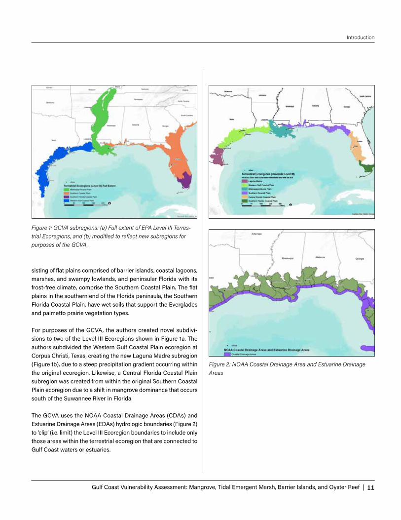
sisting of flat plains comprised of barrier islands, coastal lagoons, marshes, and swampy lowlands, and peninsular Florida with its frost-free climate, comprise the Southern Coastal Plain. The flat plains in the southern end of the Florida peninsula, the Southern Florida Coastal Plain, have wet soils that support the Everglades and palmetto prairie vegetation types. For purposes of the GCVA, the authors created novel subdivi-sions to two of the Level III Ecoregions shown in Figure 1a. The authors subdivided the Western Gulf Coastal Plain ecoregion at Corpus Christi, Texas, creating the new Laguna Madre subregion (Figure 1b), due to a steep precipitation gradient occurring within the original ecoregion. Likewise, a Central Florida Coastal Plain subregion was created from within the original Southern Coastal Plain ecoregion due to a shift in mangrove dominance that occurs south of the Suwannee River in Florida. The GCVA uses the NOAA Coastal Drainage Areas (CDAs) and Estuarine Drainage Areas (EDAs) hydrologic boundaries (Figure 2) to ‘clip’ (i.e. limit) the Level III Ecoregion boundaries to include only those areas within the terrestrial ecoregion that are connected to Gulf Coast waters or estuaries.
Figure 1: GCVA subregions: (a) Full extent of EPA Level III Terres-trial Ecoregions, and (b) modified to reflect new subregions for purposes of the GCVA.
Figure 2: NOAA Coastal Drainage Area and Estuarine Drainage Areas

12 | Forest and Wildlife Research Center | Mississippi State University
Introduction
Seaward BoundariesIn a similar effort to that for terrestrial systems, marine ecoregions were constructed as a spatial framework with three nested lev-els defined by Wilkinson et al. (2009). The GCVA used their Level III marine ecoregions, which were defined for the Gulf of Mexico Shelf, an area from the coastline to the shelf edge. These Level III marine ecoregions are the Florida Keys, Florida Bay, Shark River Estuarine Area, Dry Tortugas/Florida Keys Reef Track, Western
Florida Estuarine Area, Southwest Floridian Neritic, Eastern Gulf Neritic, Mississippi Estuarine Area, Texas Estuarine Area, Laguna Madre Estuarine Area, and Western Gulf Neritic ecoregions (Fig-ure 3). The GCVA uses the 30-meter isobaths to clip (i.e. limit) the Level III marine ecoregions to include only those areas that lie within the nearshore subsystem. The marine ecoregions were used to determine the extent of the sea surface temperature (SST) and surface ocean salinity (SOS) explained in Section 3.
Figure 3: Marine Ecoregions (Level III)

Gulf Coast Vulnerability Assessment: Mangrove, Tidal Emergent Marsh, Barrier Islands, and Oyster Reef | 13
Introduction
THE CONTEMPORARY LANDSCAPE Dahl and Stedman (2013) define the Gulf of Mexico region as the 1,630 miles of shoreline stretching from the southern coast of Texas to the Dry Tortugas in Florida. This section outlines as-pects of the contemporary Gulf of Mexico ecosystems that affect and relate to the sensitivity, exposure, and adaptive capacity of its ecosystems.
EcosystemsThe Coastal and Marine Ecological Classification Standard (CMECS) provides a national framework for defining coastal and marine ecosystems based on their physical, biological, and chemi-cal data (Madden 2006). Based on the work by Carollo et al. (2013), four of these ecosystems were chosen for focus in the GCVA: mangroves, tidal emergent marsh, oyster reefs, and barrier islands. These ecosystems were chosen by the GCVA Core Planning Team because of the availability of data and models. They are discussed further in Chapter 2, but can briefly be characterized as follows:
1. Mangroves: Tidally-influenced tropical or subtropical forests found on intertidal mud flats along estuary shores that may extend into river courses. Although most mangrove species are found primarily along the Florida coasts, black mangrove can be found as far north as Texas, Louisiana, and Mississippi. Mangroves provide habitat for crabs, shrimp, and fish, as well as rookery sites for bird colonies.
2. Tidal Emergent Marsh: Areas dominated by emergent, predominantly herbaceous vegetation found along low-wave-energy intertidal areas of estuaries. Salinities range from freshwater marsh with salinity <3 parts per thou-sand (ppt), to intermediate marsh with a range of 2–8 ppt, brackish marsh with a range of 4–10 ppt, and saline marsh-es up to 29 ppt (Chabreck 1970, Enwright et al. 2014).
3. Oyster Reefs: Ridge or mound-like structures created by the growth of oysters that are attached to a substrate of live or dead oysters and other hard substrate material, such as rock. Reefs provide structural habitat for several aquatic species, protec-tion to coastal communities by reducing storm surge, and other ecosystem services.
4. Barrier Islands: Elongate, shore-parallel islands composed of primarily unconsolidated sediments that protect the adjacent landmass and include sandy barriers, headland spits, and sandy keys (Del Angel et al. 2014). CMECS identifies several differ-ent beach types; however, the GCVA focuses on beaches and dunes that occur on barrier islands.
Gulf Coast Climate The Gulf Coast is characterized by mild winters with the occa-sional cold front and hot, humid summers. During the winter and spring, the region experiences heavy rainfall due to mid-latitude storm systems. Summer and fall precipitation is influenced by factors such as the size and position of the North Atlantic sub-tropical high (Li et al. 2011), tropical storms, and hurricanes (Keim et al. 2007). Along the northern Gulf Coast from Galveston, Texas to Apalachicola, Florida the average return period for hurricanes from 1901–2005 was less than 10 years. Global influences such as the El Niño and La Niña cycle of the El Niño/Southern Oscillation (ENSO) also contribute to the region’s climate. Presently, during El Niño, the winter and spring temperatures significantly decrease across the region while rainfall increases (CPC 2005). La Niña is associated with warm winters, higher summer temperatures, and regional droughts (Climate Prediction Center 2005). The average number of hurricanes is lower during El Niño events than La Niña events (Bell and Chelliah 2006).
Surface evaporation rates decrease as one moves from west to east (Turner 2003). This pattern affects runoff from the watersheds
Mangroves Tidal Emergent Marsh Oyster Reefs Barrier Islands

14 | Forest and Wildlife Research Center | Mississippi State University
Introduction
that feed into the Gulf of Mexico. The alteration to runoff, along with water exchange between the coastal zone and estuarine entrance, influences salinities within the northern Gulf of Mexico estuaries (Turner 2003).
Coastal and ocean currents connect the waters of the region. The Loop Current (LC) is the most dominant circulation (Karnauskas et al. 2013). It starts through the Yucatan Channel and transports water from the Caribbean into the Gulf. The LC then moves east-ward through the Florida Straits and eventually becomes the Florida Current. Changes in runoff, precipitation, temperature, sa-linity, and wind can alter currents and impact the distribution and production of coastal and marine ecosystems (Scavia et al. 2002).
Over the past 100 years, the Gulf Coast experienced changes in air and sea-surface temperature, precipitation, and extreme events. On average, air temperatures in the southeast cooled during the 20th century, especially from the 1950s to the late 1960s (Bove et al. 1998). However, since the mid-1900s, warming across the region can be attributed to increases in the daily minimum tem-perature (Powell and Keim 2015). Extreme hot and cold spells are also getting shorter. Over the entire region, extreme rainfall events increased while the duration of wet spells has decreased. An east to west pattern was detected with Florida becoming drier overall, but also more variable in rainfall by season and Texas, Louisiana, and Mississippi becoming wetter due to increases in total annual precipitation and number of days with rainfall exceeding 10mm and 20mm. Between 1941 and 1965, the Gulf of Mexico experi-enced active hurricane seasons followed by a calm period until the 1990s. Hurricanes are influenced by several climatic factors, and no historical trend in the number or location of tropical storms has been identified (Henderson-Sellers et al. 1998).
Current Ecosystem ThreatsAlthough the SIVVA tool does not specifically consider all hu-man impacts, consideration of some anthropogenic challenges —namely hypoxia, wetland loss, freshwater inflows, and invasive species—are addressed here.
HypoxiaHypoxia occurs when the dissolved oxygen concentration of the water near the bottom of the Gulf decreases to less than 2 mg/L (Louisiana Universities Marine Consortium 2015). Benthic organ-isms may be stressed or die when exposed to extended hypoxic conditions. Mobile organisms may move out of the area, reducing
fishery catch rates. The size of the hypoxic areas is influenced by human-induced increases in nutrient inputs from the watershed and by water column stratification that reduces mixing of bottom waters (Rabalais et al. 2002). The excessive nutrients lead to large productions of phytoplankton that die and sink to the Gulf floor. As bacteria decompose the phytoplankton, oxygen is consumed.
The Northern Gulf of Mexico experiences one of the largest hy-poxic events in the world with a hypoxic area that can extend up to eighty miles offshore stretching from the mouth of the Missis-sippi River west to Texas coastal waters (Mississippi River/Gulf of Mexico Watershed Nutrient Task Force 2008). Severity and spatial extent of the hypoxic region varies from year to year due to local and regional climate variability and ocean dynamics. The hypoxic zone can extend up to 125 km offshore and occur at depths as deep as 60 m. Rabalais (2014) reported the hypoxic region was 13,080 km2 and occurred in two separate areas. The largest area was off the Louisiana coast between the deltas of the Mississippi and Atchafalaya rivers, and the smaller area was off southwest-ern Louisiana. The environmental target is to reduce the hypoxic zone to 5,000 km2 (Mississippi River/Gulf of Mexico Watershed Nutrient Task Force 2013). Smaller river basins with conditions of excessive nutrients also contribute to hypoxia in the Northern Gulf of Mexico, such as the Brazos River in Texas, which experi-ences significant hypoxic events including widespread fish kills after floods (DiMarco et al. 2012). Wetland LossCoastal wetland systems in the Gulf region are very diverse and include tidally influenced riverine systems, vegetated emerging deltas, fresh to saline tidal marshes, saline coastal prairie, and the salt flats of the Laguna Madre. As such, they provide essential habitat to a diversity of mammals, birds, fish, reptiles, and amphib-ians. They filter pollutants and excess nutrients from the water, buffer upland coastal communities from erosion, and reduce hur-ricane storm surge. In the United States, the most dramatic wet-land losses occur along the Gulf Coast. Between 2004 and 2009, the Gulf of Mexico region experienced a net loss of 257,150 acres (Dahl and Stedman 2013). Losses are due to sea level rise, land subsidence, and hurricane frequency and intensity (Turner 1997). Human activities that exacerbate wetland loss include conver-sion of wetlands to other land uses, alteration to the hydrologic regime, canal and channel dredging, and fluid extraction associ-ated with maritime commerce and energy production, which in-duces subsidence.

Gulf Coast Vulnerability Assessment: Mangrove, Tidal Emergent Marsh, Barrier Islands, and Oyster Reef | 15
Introduction
Freshwater InflowsFreshwater inflow is an important influence on community struc-ture and function in the Gulf of Mexico. Throughout the Gulf re-gion, humans have altered natural physical processes through actions such as flood control, water use that reduces freshwater inflows, discharge of pollutants, and the creation of navigation channels that impact salinity regimes. River channelization in-terrupts freshwater inflows by decreasing the base flow to es-tuaries during critical dry seasons while increasing freshwater input during wet seasons (Sklar and Browder 1998). The increase in discharge can lead to increased sedimentation, rapid salinity changes, fish displacement, and shifts in plant community struc-ture. In addition, alteration to freshwater inflow patterns due to dredging, dams, or channelization of flood-prone rivers impacts the sedimentation patterns, timing, and volume of these inflows (Sklar and Browder 1998).
Perhaps the most notable changes have been to the Mississippi River watershed, which is the largest in North America draining 41% of the continental U.S. (Milliman and Meade 1983). Changes in land use throughout the watershed substantially influence the water quality entering the Gulf of Mexico by impacting the salin-ity, nutrient input, and dissolved oxygen concentrations of the receiving waters. In the case of the Mississippi River, channeliza-tion interferes with interactions between the upstream riparian zone and downstream coastal zone. The levees associated with the Mississippi River prevent sediment and nutrients from reach-ing coastal marshes (Sklar and Browder 1998). The alteration to sediment and nutrient delivery in combination with subsidence due to compaction, erosion, and dewatering has led to high rates of wetland loss.
Invasive Aquatic SpeciesAlong the Gulf Coast, over 331 non-indigenous aquatic species have been found, including water hyacinth (Eichhornia crassipes), hydrilla (Hydrilla verticillata), alligator weed (Alternanthera philoxe-roides), nutria (Myocastor coypus), Asian tiger shrimp (Penaeus monodon), and Asian clam (Corbicula fluminea) (National Ocean Service 2011). In estuarine and marine systems, introductions are often due to the shipping industry and the aquarium trade (Whit-field et al. 2002). Invasive species negatively impact native com-munities by outcompeting native species for resources, altering food webs and habitats, and introducing disease.
The Human Aspects of the Gulf CoastThe Gulf Coast has garnered much attention over the past decade, beginning with Hurricanes Katrina and Rita in 2005, followed by Hurricane Ike in 2008, and finally the Deepwater Horizon Oil Spill in 2010. These events have drawn the attention of the nation and the international community to highlight the rich cultural heritage and economic importance of the Gulf Coast.
Population and InfrastructureNOAA defines the ”Gulf Coast region” as a suite of 141 coastal watershed counties and parishes that represent a defined area for describing economic, community, and ecosystem attributes (National Ocean Service 2011). Within the five Gulf States—Texas, Louisiana, Mississippi, Alabama, and Florida—37% percent of the population lives within the coastal counties and parishes, which represent only 25% of the land area. The density of people in the Gulf Coast is roughly 184 persons per square mile, compared to the continental U.S. average of 104, which puts great pressure on the resources of the Gulf Coast region (National Ocean Service 2011).
The Gulf Coast region increased by 8.4 million people between 1960 and 2008, a 150% increase as compared to a 70% increase across the United States (Wilson and Fischetti 2010). As the popu-lation continues to grow, so do demands for new infrastructure, as well as increased pressure on natural systems. From 2000 to 2010, the region experienced a 20% increase in housing compared to 14% for the U.S. as a whole (National Ocean Service 2011).
Population projections in the Gulf region imply increasing pres-sure on ecosystems and the fish and wildlife those ecosystems support. Zwick and Carr (2006) indicated that the population of Florida will double from 18 to 36 million between the years 2005 and 2030. Similar trends are predicted for Texas, with the Texas Water Development Board (2012) predicting that the population will more than double from 20.7 million in 2000 to 46.3 million people by 2060. Projections like this make it even more imperative to have good planning in place now to ensure the sustainability of fish and wildlife resources.
EconomicsThe economy of the Gulf Coast is supported by industries closely tied to the Gulf of Mexico, including waterborne commerce, oil and gas, commercial fishing, and tourism. The Gulf is home to six of the 10 largest ports in the nation (U.S. Global Change Research

16 | Forest and Wildlife Research Center | Mississippi State University
Introduction
Program 2009). In 2009, 50% of all U.S. international trade tonnage passed through Gulf Coast ports (U.S. Army Corps of Engineers 2010). The Gulf of Mexico oil and gas industry is one of the most developed in the world, producing 470 million barrels of oil and 2.9x10⁹ thousand cubic feet of natural gas per year in U.S. waters (Karnaukas et al. 2013). Commercial fishing is a multi-billion dol-lar industry responsible for 1.2 million tons of seafood in 2012 and representing 14% of the commercial landings for the U.S. (National Marine Fisheries Service 2014). The tourism industry, estimated to be worth $20 billion annually, thrives due to the beaches and recreational fishing opportunities, among other commodities that drive visitors to the region (Karnauskas et al. 2013). These activities have a direct effect on the Gulf’s ecosystems and species by way of accidental introductions of non-native species via the shipping industry, fishing pressure on fish populations, and disturbance of shorebirds from beach visitors.
Culture Coastal ecosystems and their associated resources are of cen-tral importance to coastal communities that are largely depen-dent on the sea for their livelihood, food, and leisure (Dillard et al. 2013). As such, a decline in ecosystem health due to events like hurricanes, hypoxic events, and oil spills can have a direct and significant impact on the economy and overall well-being of coastal citizens. The tightly linked economic and environmental conditions in coastal communities affect the socio-economic and cultural conditions the individuals in those communities experi-ence. Given this dependency, Dillard et al. (2013) employed the concept of well-being and developed an assessment approach that would enable researchers to better understand and measure the complex social and environmental interactions experienced in coastal communities.
Expanding on the reality that ecosystems serve as the basic foun-dation for life, a central premise of Dillard’s assessment is that hu-mans, including their socioeconomic basis and culture, are best understood in the context of the ecosystems in which they exist.
With respect to vulnerability, this study looked at poverty rates in select coastal counties and found that the average percent of people of all ages in poverty for the sample counties was roughly between 15% and 16% for all time points, whereas the U.S. average poverty rate for 2008 was 13.2% (Dillard et al. 2013). Resources are needed to adapt to climate change and its associated impact on coastal communities, so a higher poverty rate is worrisome when looking at the overall resiliency of coastal communities (Oxfam America 2009).
1 Port of South Louisiana, LA (1); Port of Houston, TX (2); Port of Corpus Christi, TX (5); Port of New Orleans, LA (6); Port of Beaumont, TX (7); Port of Texas City, TX (10) (American Association of Port Authorities 2012).

Gulf Coast Vulnerability Assessment: Mangrove, Tidal Emergent Marsh, Barrier Islands, and Oyster Reef | 17
2. ECOSYSTEMS AND SPECIES ASSESED
The GCVA evaluated four coastal ecosystems—mangrove, tidal emergent marsh, oyster reef, and barrier islands—which were chosen primarily on the availability of data and models. In the future, additional ecosystems can be evaluated as improvements on this initial effort. The species were chosen because they are widely distributed across the Gulf, are recognized as conservation targets by at least one LCC, and are representative of how other species may be impacted by projected changes.
This section describes the four pilot ecosystems and eleven asso-ciated species that were assessed and highlights the importance of key climatic and environmental stressors, such as sea level rise, storm events, temperature, precipitation, and freshwater inflows. MangroveMangrove is both a collection of trees and shrubs and a natural community found at the interface of land and sea in tropical and semi-tropical areas. There are four dominant mangrove species in the Gulf of Mexico: Rhizophora mangle (red mangrove), Avicen-nia germinans (black mangrove), Laguncularia racemosa (white mangrove), and Conocarpus erectus (button-mangrove or button-wood). Black mangroves are the most tolerant of winter extremes and have the most northern range limit (McMillan and Sherrod 1986). In general, the mangrove community is a colonizer of the intertidal zone and has adapted to changing salinities, inundat-ed soils, shifting sediments, and dynamic coastlines. A possible exception is Conocarpus erectus, which does best on sheltered shorelines where freshwater flows and/or rainfall dilute seawater (Spalding et al. 2010).
The northern extent and coverage of mangrove fluctuate in re-sponse to the duration, intensity, and frequency of extreme freeze events (Osland et al. 2013). Rainfall and freshwater inflows also affect mangrove distribution, particularly in the Western Gulf. Mangrove distribution is restricted to the inter-tropical zone, be-tween 30°N and 30°S latitudes and effectively follows the 20°C isotherm of seawater temperature, which depends on sea cur-rents and can thus vary between winter and summer (Godoy and De Lacereda 2015).
Relatively mild winters over the past several decades have led to mangrove expansion into areas previously occupied by salt marsh
plants (Armitage et al. 2015). Historically, high salinity and peri-odic freeze events have limited mangrove expansion, but chang-ing climate patterns have resulted in mangroves displacing salt marshes in certain bays, such as Aransas Bay in Texas. However, when analyzed at a larger, regional level, this shift is not wide-spread. Instead, local, relative sea level rise is an important driver causing regional-level salt marsh loss.
Mangroves are a particularly sensitive ecosystem due to their narrow environmental tolerances, geographically restricted dis-tribution, proximity to dense human populations in coastal zones, and their reliance on a few key framework species (Godoy and De Lacereda 2015, Laurance et al. 2011). Mangroves are vulnerable to changes in climatic conditions, especially freezing temperatures, rainfall, and the frequency of coastal storms (Alongi 2015). Man-groves are able to keep pace with sea level rise through soil ac-cretion as long as sea level rise remains below a certain threshold, about 12 cm per 100 years, but possibly up to 45 cm per 100 years (Ellison 2003). They are also able to adapt to changing conditions through migration to new areas that become suitable due to in-undation and increasing salinity levels as relative sea level rises. However, human use stressors such as shoreline modification, the loss of adjacent natural ecosystems to development, and the reduction of water quality can stress mangrove communities and make them more vulnerable to changing climate and sea levels.
Mangroves provide important ecosystem services to the regions in which they are found. They protect coasts from the effects of tropical storms and provide erosion control, water purification, and carbon sequestration. Many commercial fish species use man-grove roots as breeding and nursery habitat (Barbier et al. 2011).
The focal species associated with mangroves for the purpose of this assessment is the roseate spoonbill.
2 Short descriptions of additional ecosystems are included in Appendix 7.
18 | Forest and Wildlife Research Center | Mississippi State University
Ecosystems and species assessed
Roseate SpoonbillThe roseate spoonbill (Platalea ajaja) is the only spoonbill that lives in the Western Hemisphere. It is a resident breeder in the Gulf of Mexico nesting along the coasts of Texas, Louisiana, and south Florida (Dumas 2000). Outside of the breeding season, the roseate spoonbill can be found throughout the entire U.S. portion of the Gulf of Mexico coastline.
Roseate spoonbills feed on small fish and crustaceans. They are tactile foragers that feed most successfully when prey densities are high, which occurs when tides drop or drying wetlands con-centrate prey into the deeper remaining pools (Lorenz 2000). For-aging habitat includes marine, estuarine, and freshwater sites such as tidal pools, estuarine and freshwater sloughs, mudflats, and mangrove-fringed creeks and can be farther inland than nesting sites (Lorenz 2000). Nesting is typically more restricted to man-grove islands and occasionally dredged-material islands, but also coastal swamp forests.
Roseate spoonbills reach sexual maturity at 3–5 years. Females typically lay 2–5 eggs that hatch after approximately 224 days (Du-mas 2000). Both parents incubate the nest. The young are able to fly as early as 6 weeks after hatching and typically have a 25-year lifespan (J. Lorenz pers. comm.).
Tidal Emergent MarshTidal emergent marsh systems are a critical ecosystem along the Gulf Coast that support high levels of biodiversity and provide im-portant ecosystem services, such as providing habitat for wildlife, fish, and other aquatic organisms and buffering coastal storms. The physiological tolerance of marsh species to salinity and inun-dation determine their abundance and often result in their use of the following three zones: salt marsh, brackish marsh, and fresh marsh (Battaglia et al. 2012). These three zones are the focus of the GCVA. Causes of zonation possibly include succession (Glenn-Lewin et al. 1992), nutrient availability (Rogel et al. 2001), and intra- and inter-specific competition (Lenssen et al. 2004), suggesting that the dynamics behind marsh zones require additional studies of physical, chemical, and biotic interactions.
Marsh elevation is a critical factor that determines not only the level of inundation, but also the ability of marsh species to sur-vive and colonize new areas in response to rising sea levels. Tidal marshes may also be classified by relative elevation with respect to the tidal frame. Definitions on this basis include high, interme-diate and low marsh, sometimes classified as regularly-flooded and irregularly-flooded. Relative elevation can interact with salin-
ity to influence vegetation composition and growth. For example, high salt marshes are infrequently flooded by tides and dominated by herbaceous, emergent vegetation and forb-like dwarf shrubs due to evaporation-driven accumulation of salt in marsh soils. In contrast, intermediate and low salt marshes are more frequently flooded by tides and support more flood tolerant species.
Tidal marshes have been widely studied, providing a high under-standing of the threats and stressors that most impact these eco-systems (Battaglia et al. 2012). However, there are uncertainties in scientists’ ability to predict how tidal marshes and the species that depend upon them will respond to these stressors over time and in their ability to adapt to changing conditions. Marsh elevation is affected by coastal storms, which not only inundate marshes with saline waters, but also affect the amount of sediment either deposited or eroded from the shoreline (Battaglia et al. 2012). Dis-turbance, either from coastal storms or human activities such as shoreline modification, can also increase vulnerability to the es-tablishment of invasive species that can alter marsh community compositions or food webs (Chabreck 1970). Furthermore, inva-sive species possess qualities that may enable them to respond more positively to climate change than native species (Hellmann et al. 2008). The ability of invasive species to exclude native spe-cies is not well understood (Minchinton et al. 2006), nor is it easy to identify potentially problematic species because there is not one unifying “invasive” characteristic (Zedler and Kercher 2004).
The focal species associated with tidal emergent marsh for the purpose of this assessment are blue crab, clapper rail, mottled duck, and spotted seatrout.
Blue CrabBlue crab (Callinectes sapidus) inhabits coastal waters from Mas-sachusetts to the eastern coast of South America, including coast-al waters of the Gulf of Mexico (Perry and McIlwain 1986). Shallow salt marsh and seagrass beds provide nursery habitat for juvenile crabs (Morgan et al. 1996). Mating occurs primarily in low-salinity waters of upper estuaries and lower portions of rivers. After mat-ing, females will migrate to high-salinity waters in lower estuaries to the open Gulf to spawn (Hench et al. 2004, Aguilar et al. 2005), while males remain in the creeks, rivers, and upper estuaries. Blue crabs rarely move from one estuarine system to another. Blue crab distribution is influenced by food and shelter availability, water temperature, and salinity (Perry and McIlwain 1986).
Males mate for the first time during the third or fourth intermolt after maturing. Female crabs mate once in their lifetime, follow-

Gulf Coast Vulnerability Assessment: Mangrove, Tidal Emergent Marsh, Barrier Islands, and Oyster Reef | 19
Ecosystems and species assessed
ing the terminal molt to maturity, but store the sperm in seminal receptacles for multiple uses during a 1- to 2-year period (Dickin-son et al. 2006; Darnell et al. 2009). Fertilized eggs are extruded into a cohesive mass that contains 1–7 million eggs and is carried by the female for a ~10 day embryonic development period (Gra-ham et al. 2012).
The blue crab is a valuable commercial species across its range and also has an important role in the structure and function of the estuary. In 2012, nearly 180 million pounds of hard blue crab were commercially landed nationally (a decrease of 9 percent from 2011), of which 53 million (a decrease of 3 percent) were landed in the Gulf Region (NOAA 2013). The blue crab is an im-portant link in the estuarine food chain, serving as detritivores and scavengers throughout their range. They also act as both prey and consumers of plankton, invertebrates, fish, and other crabs. The blue crab is prey for several recreationally important fishes including spotted seatrout (Cynoscion nebulosus) and red drum (Sciaenops ocellatus).
Clapper RailAlong the Gulf Coast, clapper rail (Rallus crepitans) distribution depends on the presence of tidal salt marsh and fiddler crab (Eddleman and Conway 2012). During low tide, rails move to ex-posed mudflats where they feed on fiddler crabs, their primary prey. Other food sources include minnows, insects, other birds’ eggs, and, occasionally, small immobilized birds (Rush et al. 2010).
Nesting along the Gulf Coast begins in spring and extends to mid- to late summer (Rush et al. 2012). Nests constructed of marsh grasses are built by males in higher areas of tidal marsh to avoid inundation during high tides. Females typically lay between 7–14 eggs, and the breeding pair takes turns incubating the nest for 20–24 days. Young are able to leave the nest soon after hatching and can fly by 63–70 days (Rush et al. 2012). Clapper rails may have 1–2 broods per season. Following nesting, adults become flightless for several weeks as all flight feathers are dropped simultaneously. Almost contrary to this, and in addition to the fact that they are non-migratory, rails are excellent long-distance dispersers.
Mottled DuckThe mottled duck (Anas fulvigula) is a resident species that occurs along the Gulf Coast in two distinct populations. One inhabits pen-insular Florida and the other is found from Alabama southwest to Tampico, Mexico (Bielefeld et al. 2010). Banding from thousands of birds indicates little to no exchange between the Florida and Western Gulf populations (Wilson 2007). The Mottled duck is a
minor component of the overall waterfowl harvest in Texas and Louisiana. In the Western Gulf Coast, mottled duck use tidal fresh, intermediate, and brackish marshes as well as non-tidal freshwa-ter wetlands and agricultural lands, notably rice and pasture. In peninsular Florida, they primarily use freshwater emergent wet-lands and agricultural lands; however, they have also been found in artificially-created wetlands in urban and suburban areas.
Breeding pairs are formed from October through January. Breed-ing occurs from February through June. Nests are typically built in upland grass areas near wetlands and are often more than 1 km away from brood-rearing habitat. Males molt in July, while females molt in August and September after brood-rearing. Salinities of >9 ppt negatively affect mottled duckling survival (Moorman et al. 1991). Increased salinity through sea level rise could make these ducklings vulnerable.
Spotted SeatroutSpotted seatrout (Cynoscion nebulosus) is common along the en-tire Gulf Coast but are most abundant off of south Texas, eastern Louisiana, Mississippi, and Alabama (Lassuy 1983, Blanchet et al. 2001). They depend on estuaries for feeding, spawning, and nurs-ery grounds. As top carnivores, they may help with the structure and function of estuarine communities. Spotted seatrout support valuable commercial and recreational fisheries.
Seagrass beds, where they occur, are the preferred habitat of post-larvae, juveniles, and adults; however, spotted seatrout may also occur abundantly near shell reefs, marshes, and submerged or emergent islands. Food availability in combination with a suitable salinity and temperature regime may also play an important role in the locations where they are found (Perret et al. 1980).
Spawning typically occurs at the end of the second or third year but has been reported as early as the end of the first year in both sexes. Peak spawning in the Gulf of Mexico occurs between late April and July. Egg estimates have ranged from 15,000 to 1.1 million, suggesting there may be variation among individuals or among estuaries (Brown-Peterson and Warren 2001).
Oyster ReefAlong the coast of the Gulf of Mexico, the eastern oyster (Crassostrea virginica), also known as the American oyster, is the dominant reef-building organism within the estuaries. Human activities, including altered river flows and over-harvest, have led to enormous losses of oyster reefs worldwide, with many reefs and populations being damaged beyond repair (Beck et al. 2011).

20 | Forest and Wildlife Research Center | Mississippi State University
Ecosystems and species assessed
Oyster reefs are distributed throughout the Gulf of Mexico, and despite greater than 50 percent loss, this region is one of the few oyster ecosystems still in fair condition, making it possible to re-pair and restore oyster reefs to historical levels (Beck et al. 2011).
Along the northern Gulf Coast, oysters are sensitive to freshwa-ter inflow into the estuaries. Increases in freshwater inflow lower salinity. If salinity decreases below 5 ppt for extended periods of time, oyster growth rates decrease, which may prevent spawning and possibly lead to increased mortality. In contrast, too little in-flow may result in higher salinity, which can lead to increased pre-dation pressure and disease prevalence. Numerous experimental and modeling results support these linkages. Beyond changing salinity, human activities involving alteration of the substrate may result in significant damage to oyster reefs through direct physi-cal impacts (Vanderkooy 2012). This stressor and its effects are highly predictable.
Oysters and the reefs they form provide a variety of ecological services. Oysters improve water quality and water clarity through their filtration of water in the course of consuming algae; oysters filter up to 10 liters of water per gram of oyster tissue per hour (Jordan 1987). They are also ecosystem engineers, forming reefs from the shells of oysters both living and dead, which then pro-vide a hard substrate for oyster larvae to settle, continuing the reef building cycle. Oyster reefs also provide important habitat for many different species, alter currents, and reduce storm surge.
The focal species associated with oyster reefs for this project are eastern oyster, American oystercatcher, and red drum.
Eastern OysterEastern oyster (Crassostrea virginica) is a commercially important species scattered throughout the bays and estuaries of the Gulf of Mexico. The eastern oyster is widely distributed in America from the Gulf of St. Lawrence, along the Atlantic coast of the United States, to the Gulf of Mexico, and through the Yucatan Peninsula to the West Indies and the coast of Brazil (Buroker 1983). Oyster growth rate is dependent on temperature, salinity, and food supply. In the Gulf of Mexico, the optimum temperature range for oyster growth is from 20–30°C (Eastern Oyster Biological Review Team 2007). Eastern oysters are abundant in shallow saltwater bays, lagoons, and estuaries, thriving in water temperatures that can fluctuate between -2 and 32°C.
Oysters are filter feeders that feed primarily on phytoplankton and
suspended detritus. When water temperatures exceed 35°C or drop below 5°C, the filtering rate slows and feeding rate is affected. Oysters occur in areas with salinities between 0 and 40 ppt, with little growth occurring when salinities drop below 5 ppt (Eastern Biological Review Team 2007). As salinity levels increase, so do the threats from predators (such as the Southern oyster drill, Stra-monita haemastoma) and parasites such as Perkinsus marinus.
American OystercatcherAlthough there are two races of American oystercatcher (Haema-topus palliatus) in the United States, only the eastern race (Haema-topus palliatus palliatus), which occurs broadly from Nova Scotia to eastern Mexico, is found in the Gulf of Mexico. Within the Gulf of Mexico specifically, the American Oystercatcher Working Group (2012) identifies distribution from Lee County north to Bay County in Florida, with smaller populations of breeding birds in Alabama and Mississippi and west to Louisiana and Texas.
Along the Gulf Coast, American oystercatchers traditionally nest on barrier beaches, sandbars, shell islands, and marsh islands, but they have been found nesting on dredged-material islands and rooftops (Florida Fish and Wildlife Conservation Commission 2013). Nests, which are shallow depressions of scraped sand, are made in areas surrounded by water. After breeding season, roost-ing sites are typically utilized near feeding areas disconnected from the mainland. These birds often use shell rakes, which are aggregations of oyster and other shells found along the edges of marshy islands, for nesting and roosting (American Oystercatcher Working Group 2012). Their specialized bill makes them depen-dent on oysters and other bivalves as main sources of food.
American oystercatchers reach sexual maturity between 3 and 4 years of age and can live for more than 10 years (Schulte et al. 2007). Nesting season runs from February to August, and the fe-male typically lays 2–4 eggs. Chicks are mobile within 24 hours of hatching but remain with parents for up to 6 months.
Red DrumRed drum (Sciaenops ocellatus) is a highly mobile species found along the entire Gulf Coast (Powers et al. 2012). Total estuarine area seems to affect their abundance (Yokel 1966). Females can produce up to 2 million eggs and spawning peaks in September or October (Matlock 1987, Davis 1990). Larvae are carried by Gulf surface currents into estuarine nurseries. During this time, the fish are sensitive to poor water condition. Temperature and salinity affect larval development with larvae in warmer waters reaching

Gulf Coast Vulnerability Assessment: Mangrove, Tidal Emergent Marsh, Barrier Islands, and Oyster Reef | 21
Ecosystems and species assessed
juvenile stages faster than larvae in cooler waters (Davis 1990). Early cold spells reaching the Gulf can cause mass mortality. Lar-val fish also have little tolerance to low salinities.
Juveniles are found solely in the estuarine nursery and are more tolerant to low salinities than larvae. Tolerance to low salinity in-creases with age (Perret et al. 1980). Juveniles prefer seagrass beds, shorelines, and shallow waters. They feed on shrimp, young blue crabs, copepods, gammarid amphipods, and fish. The red drum reaches sexual maturity around 3–6 years of age (Davis 1990). Adult drum are typically found within 5 miles of the Gulf shore. They are primarily bottom-feeders, but larger drum will feed on other fish. At this stage, the fish have the highest tolerance for a range of temperatures and salinities; however, they are sensitive to rapid and prolonged drops in water temperature.
Red drum was overfished for many years and is now closely regu-lated. Although a very popular game fish, commercial harvesting of red drum continues to be prohibited throughout the Gulf Coast states with the exception of Mississippi (Florida Fish and Wildlife Conservation Commission 2015). Red drum is vulnerable to deg-radation and destruction of estuarine habitat.
Barrier IslandsThere are a total of 72 sand-rich barriers along the Gulf Coast that vary in character, composition, and level of human impact (Del Angel et al. 2014). Although barrier islands have a range of geoenvironments, beaches and dunes are the focus of the GCVA. Del Angel et al. (2014) identify these barrier islands both across the Gulf Coast and by state.
Barrier islands are the first line of defense for protecting main-land coastal ecosystems from the direct effects of wind, waves, and storms. They also help maintain gradients between saline Gulf waters and inland estuarine systems (Del Angel et al. 2014). Formed during the deceleration of sea level rise over the past 5,000 years, these islands persist from sand delivered from on-shore sources and longshore transport. This migrating ecosys-tem is highly vulnerable to reductions in sand transport (through human modification), rising sea level, and tropical cyclones and storms, which can significantly change inundation regimes af-fecting the geomorphic structure of the barrier islands and the habitats they support. Long-term aerial imagery and sequential shoreline and bathymetric surveys along the barrier islands of the northern Gulf of Mexico have provided much of the understand-
ing on geomorphic processes that dominate barrier island change and vulnerability. (Del Angel et al. 2014).
The focal species associated with barrier islands for this project are black skimmer, Kemp’s ridley sea turtle, and Wilson’s plover.
Black SkimmerThe black skimmer (Rynchops niger) is a beach-nesting species found along the Atlantic coast from Massachusetts to southern Florida and west into the Gulf of Mexico through coastal south Texas (Gochfeld and Burger 1994). Western populations also exist from California south through tropical South America.
Black skimmers nest in colonies on sparsely vegetated beaches, spoil islands, and occasionally gravel rooftops where nest success is poor (Gochfeld and Burger 1994, Florida Fish and Wildlife Con-servation Commission 2013). Nests are made by creating slight depressions in the sand in which 3–4 eggs are laid (Gochfeld and Burger 1994).
Black skimmers forage for prey by dragging the lower bill through the water as they fly and closing the upper bill reflexively when prey is contacted (Florida Fish and Wildlife Conservation Commis-sion 2013). Foraging sites include shallow waters offshore, fresh-water bodies, estuaries, lagoons, and impoundments.
Kemp’s Ridley Sea TurtleKemp’s ridley (Lepidochelys kempii) is a highly migratory species of sea turtle that forages at sites throughout the Gulf of Mexico. The three main nesting regions are in in the state of Tamaulipas, Mexico; however, they do nest in the U.S., with the majority being in Texas and a few nests along the Florida panhandle (National Marine Fisheries Service et al. 2011). Kemp’s ridley nesting occurs, typically in the daylight hours, in synchronized events called “ar-ribada” (arrival) (National Wildlife Federation 2015). Kemp’s ridley occupies many areas within the Gulf of Mexico, with their primary habitat being the nearshore and inshore waters.
The Kemp’s ridley reaches maturity at 10–15 years of age. Once they have hatched, males spend their entire lives at sea, while females leave the ocean only to lay eggs. Female turtles con-gregate in shallow water and all emerge at once to lay eggs on the beach (the arribada). On average, females lay 1–4 clutches of eggs every two years. Each clutch can have between 50 and 130 eggs (Pritchard and Marquez 1973). When female hatchlings

22 | Forest and Wildlife Research Center | Mississippi State University
Ecosystems and species assessed
reach maturity, they return to the site where they hatched to lay their own eggs, but sometimes move to other beaches. Adults mainly occupy neritic habitats that have muddy or sandy bottoms where prey can be found. Their diet consists mainly of swimming crabs, but they also eat jellyfish, fish, and mollusks (Pritchard and Marquez 1973).
Kemp’s ridley are the world’s most endangered sea turtle due to overharvesting of eggs and loss of juveniles and adults to com-mercial fishing activities in the mid-1900s (Plotkin 1995). From 2009 to 2015, there has been a 40% decline in Kemp’s ridley nests; the cause of this decline is still being researched.
Wilson’s PloverWilson’s plover (Charadrius wilsonia) is a medium-sized shorebird found primarily in coastal ecosystems. It can nest in a variety of
beach microhabitats from barren to densely vegetated substrates above the high-tide line (Zdravkovic 2013). They are visual feed-ers that prefer fiddler crabs and other small crustaceans found on exposed mudflats. Within the U.S. portion of the Gulf of Mexico, Wilson’s plover breeds across the region from Florida to south Texas and winters primarily in northeast and central Florida, west Louisiana, and Texas (Corbat and Bergstrom 2000).
The males build nests by making multiple scrapes in the sand of sparsely vegetated saline areas such as beaches above high tide, dune areas, and the edges of lagoons. Females lay 2–4 eggs, and parents share incubation for approximately 28 days (Corbat and Bergstrom 2000). If a nest fails, renesting can occur with 5–13 days (Bergstrom 1988). Chicks are mobile shortly after hatching and use nearby vegetation to hide.

Gulf Coast Vulnerability Assessment: Mangrove, Tidal Emergent Marsh, Barrier Islands, and Oyster Reef | 23
3. METHODS
The GCVA utilized expert opinion that was gathered through the Standardized Index of Vulnerability and Value Assessment (SIVVA) , which is an Excel-based vulnerability and prioritization tool developed by Reece and Noss (2014) that enables assessors to provide input in a relatively short time and allows for relatively seamless compilation of results.
The vulnerability of each ecosystem and associated species was conducted by subregion, excluding those subregions where the species did not occur in significant numbers. Assessors were asked to evaluate species based on the habitats they use in a par-ticular subregion. Because vulnerability can vary with life-stage for many species, assessors were asked to consider the most vulner-able life-stage of the species for each criterion scored. TimeframeThe year 2060 was chosen to assess future conditions because it coincides with other projects along the Gulf Coast such as the Southeast Conservation Adaptation Strategy (2014), Florida Statewide Climate Scenarios (Vargas et al. 2014), and the State of Louisiana’s Coastal Master Plan (Coastal Protection and Restora-tion Authority 2012). If projections for 2060 were not available for a given model, the closest time step available was used, which for sea level rise scenarios was 2050.
Expert Engagement The SIVVA tool requires input from species and ecosystem ex-perts. It effectively quantifies otherwise qualitative data via the spreadsheet format. Through this effort, 144 ‘sets’ of assessments were completed by 59 individuals across the Gulf Region (Figure 4). For a given species or ecosystem in a particular subregion, each ‘set’ includes an assessment for each of three climate sce-narios, which are described in more detail below. Guidance given to individuals completing species assessments was to assess the species over the entire subregion, while guidance for those com-pleting habitat assessments was to focus on the specific ecosys-tem within the subregion.
Assessors were engaged through a number of methods. These assessors or ‘experts’ are people who have enough of a working knowledge of an ecosystem or species in an area to make an as-
sessment of how that species or ecosystem is likely to be affected by the changes predicted. Engagement of these individuals was led by Ecosystem and Species Expert Team (ESET) leads. These teams organized around the mangrove, tidal emergent marsh, oyster reef, and barrier island ecosystems. More details on en-gagement procedures are included in Appendix 3.
The goal was to have at least two independent assessments com-pleted in each ecosystem and species for each of the six Level III Ecoregions. This proved to be challenging for some species given limited data and, in some cases, limited response from individu-als who considered themselves experts. Despite these challenges 59 experts were engaged in the process and are listed at the end of this report.
Assessments were organized by each of the six subregions with most assessors focused on a single species or ecosystems in a subregion. However, some completed multiple assessments for species and/or ecosystems across multiple subregions, and sev-eral individuals completed assessments for an ecosystem or spe-cies across all 6 subregions.
3 The tool can be accessed online at: http://noss.cos.ucf.edu/publications/sivva.4 Note that Kemp’s ridley was only assessed in 3 of the 6 subregions, and barrier islands were assessed in 5 of the 6 subregions.
Figure 4: Number of species and ecosystem assessments completed by subregion.4 Ecosystems bars are colored red and species bars are blue.

24 | Forest and Wildlife Research Center | Mississippi State University
Methods
Standardized Index of Vulnerability and Value AssessmentThe SIVVA comes in two forms, a version for species and another for natural communities. Each form contains four modules, two of which were used to calculate the species and habitat vulnerabil-ity score for the GCVA (Table 1). The results from the Information Availability module are not included in the vulnerability score but are discussed in Section 6.
SIVVA for Species is an assessment and prioritization tool that incorporates threats from climate change, land use change, and sea level rise into a transparent and flexible quantitative framework (Reece and Noss 2014).
In SIVVA for Species, the Vulnerability (Exposure + Sensitivity) module, referred to as ‘Potential Impact,’ contains 12 criteria that address threats such as habitat loss to sea level rise, erosion, and land use change, and species sensitivity to temperature, precipi-tation, and salinity changes. The Adaptive Capacity module con-tains 6 criteria that address intrinsic characteristics of the species that may allow it to cope with projected changes, such as species mobility, genetic diversity, and ability to colonize new areas. The criteria are explained further in Appendix 2.
SIVVA NATCOM (NATural COMmunities) was developed to fill important gaps in existing tools for ecosystem assessment. At the time of its development in December 2012, 7 major ecosys-tem assessment tools were identified and built upon. These in-cluded work completed for the International Union for Conserva-
tion of Nature (IUCN) by Rodriguez et al. (2011) and Holdaway et al. (2012); international work by Benson (2006) and Paal (1998); a national NatureServe effort by Master et al. (2009); a review of 12 ecosystem assessments in Nicholson et.al. (2009); and, the North-east Association of Fish and Wildlife Agencies (NEAFWA) model (National Wildlife Federation and Manomet Center for Conserva-tion Sciences. 2014). The review of these assessments led to the development of SIVVA NATCOM.
In SIVVA NATCOM, the Ecosystem Status module draws heavily from the IUCN. Ecosystem status includes three sets of criteria, of which the set with the highest score (the worst status) is taken forward and the others are ignored (Appendix 2). The first set of criteria assesses the decline in area over the last 50 years, since 1750 (pre-Columbian era), and over any 50-year period including the present and future. The second set of criteria assesses the de-cline in ecosystem function over the same three timeframes. The third set of three criteria assesses the rarity of an ecosystem type with a focus on important differences between geographic extent, area of occupancy, and total acreage. These differences address the subtleties of how area is calculated; for example, several small, isolated habitat patches that form the same area as fewer large and continuous patches.
The second module is Vulnerability (hereafter referred to as Po-tential Impact) and includes 9 criteria (Appendix 2). These include quantitative estimates of area loss due to sea level rise and land use change. Qualitative assessments include the impacts of frag-mentation, alteration of disturbance regime, altered hydrology, in-herent or imposed limits on range shifts, degradation of the abiotic environment, and other factors that would alter biotic processes and interactions. Ecosystem vulnerability scores were calculated by averaging the scores for the Ecosystem Status and Potential Impacts modules.
The benefits of SIVVA NATCOM over existing assessments is that while it includes all of the major categories of existing tools, it standardizes the score (a number between zero and one), pro-vides a flexible framework for weighing different types of infor-mation differently, and it is transparent in the way that different information is valued.
Both the SIVVA for Species and SIVVA NATCOM have the same scoring system. Experts are given specific guidelines for each criterion on how to provide a numerical score between 0 and 6.
Table 1: Modules used to calculate vulnerability in SIVVA
Species Assessment Natural Communities Assessment
Vulnerability (Exposure + Sensitivity)*
Ecosystem Status
Adaptive Capacity (lack thereof)
Vulnerability*
* This is what the GCVA refers to as Potential Impact.

Gulf Coast Vulnerability Assessment: Mangrove, Tidal Emergent Marsh, Barrier Islands, and Oyster Reef | 25
Methods
In this scoring system: • 0 means that not enough information is available; • a score of 1 or 2 means positive impacts; • a score of 3 means no impact; and,• a score of 4, 5, or 6 means increasingly negative impacts.
Criteria within each module of SIVVA are weighted and weights may be adjusted. A summary score was computed for each mod-ule by multiplying the weight of the criteria by the score from 1 to 6 and normalizing by the maximum total number of points. An overall vulnerability score was tallied by averaging two modules. For the species, the vulnerability score was calculated by averag-ing Potential Impact and Adaptive Capacity scores. For the eco-systems, the vulnerability score was calculated by averaging the scores for the Ecosystem Status and Vulnerability modules. These are the values depicted on the maps in Section 4.
Two types of uncertainty were accounted for: (1) scoring uncer-tainty, when an expert thinks more than one value is likely; and (2) insufficient knowledge due to limited data available for the species.
To account for scoring uncertainty, assessors could check a box next to the criterion to show they are not sure of the proper score. In the final score computation, 0, +1, or -1 is added to the score that is marked as uncertain, and 1000 Monte Carlo simulations are run to recalculate the effect on the overall score. Insufficient knowledge is accounted for by reporting the proportion of criteria scored and by comparing the summary score to the proportion calculated as the total points divided by the maximum possible points available if all criteria had been scored.
Supporting InformationAll individuals conducting assessments were provided consistent and relevant data on climate projections, sea level rise, and maps pertaining to the subregions.
Climate ProjectionsThe Intergovernmental Panel on Climate Change (IPCC) devel-oped qualitative future greenhouse gas emission storylines as part of the Third and Fourth Assessment Reports that describe different demographic, social, economic, technological, and en-vironmental developments. The storylines are all considered equally plausible future outcomes that span a wide range of fu-ture greenhouse gas emissions. For the GCVA, air temperature
and precipitation were based on scenarios from the A2 and B1 storylines (IPCC 2000).
Sea surface temperature (SST) and surface ocean salinity (SOS) were not available for the A2 and B1 emission scenarios. Instead, the GCVA used sea surface temperature and surface ocean sa-linity that are based on Representative Concentration Pathways (RCPs) scenarios 2.6 and 8.5. RCPs were used by the IPCC for the Fifth Assessment Report (AR5) (IPCC 2014). RCP 2.6 results in a similar but lower forcing trajectory as the B1 storyline and RCP 8.5 has a similar but higher forcing trajectory as the A2 sto-ryline (Figure 5).
The sea level rise rates used in the GCVA fell within the range of possible future scenarios as described in the Global Sea Level Rise Scenarios for the United State National Climate Assessment (Parris et al. 2012). The GCVA used sea level rise amounts of 1.0 m and 2.0 m by 2100 that were adjusted to 0.41 m and 0.82 m for the year 2050, which was as close as possible to the SECAS 2060 timeframe.
Assessors were asked to evaluate species and ecosystem vulner-ability under three different scenarios: 1. low CO2 emissions (B1 and RCP 2.6) and low (0.41 m) sea level rise2. low CO2 emissions (B1 and RCP 2.6) and high (0.82 m) sea level rise3. high CO2 emissions (A2 and RCP 8.5) and high (0.82 m) sea level rise
For each subregion, climate summaries showing changes in seasonal averages for precipitation and air temperature were provided to assessors (Appendix 4). Downscaled precipitation and air temperature projections from climate models used in the IPCC Fourth Assessment were obtained from Stoner et al. (2013). For SST and SOS, downscaled model output from the AR5 is not available and is not likely to appreciably improve guidance about future changes since the spatial variability in the surface ocean layer tends to be less than in the atmosphere. Therefore, for SST and SOS, climate summaries were provided for the entire seaward boundary as identified in Figure 3. For all climate parameters, cli-mate projections for 2050–2069 were averaged and compared to the base period 1980–1999.
5 Note that high emissions and low sea level rise (0.41m) were not evaluated because the scenario is not likely to occur.

26 | Forest and Wildlife Research Center | Mississippi State University
Methods
Map LayersMaps containing data layers showing species and ecosystem distributions, sea level rise projections, urbanization projections, and conservation lands were created on the Conservation Plan-ning Atlas (Gulf Coast Prairie LCC 2014). Information about each data source is provided below.
Terrestrial Conservation Estate, Southeast RegionThe Conservation Biology Institute (CBI) has managed a Protected Areas Database (PAD) for the United States since 1999 (Conserva-tion Biology Institute 2012). The PAD-US (CBI Edition) Version 2 is a national database of lands owned in fee that is designed to be used along with the National Conservation Easement Database (NCED) to visualize the entire terrestrial conservation estate of the continental United States, Alaska, and Hawaii.
The PAD-US (CBI Edition) Version 2 dataset portrays the nation's protected areas with standardized spatial geometry and numerous valuable attributes on land ownership, management designations,
and conservation status. The IUCN defines a protected area as: “A clearly defined geographical space, recognised, dedicated and managed, through legal or other effective means, to achieve the long-term conservation of nature with associated ecosystem ser-vices and cultural values” (Dudley 2008 pp.8). The database repre-sents the full range of fee conservation designations that preserve these natural resources in the United States, and is scheduled to be updated annually. It was created to help people integrate fee land protected areas data into a number of planning exercises, including those that pertain to issues such as climate adaptation and wildlife connectivity, both of which are pertinent to the GCVA.
Projected Urban Growth for the Gulf of MexicoThe Assessment Team used a high-resolution regional proba-bilistic projection of urban growth to 2060 for the Southeast U.S., which encompasses the 5 Gulf States (Gulf Coast Prairie LCC 2014). Further model modification and implementation was performed at the Biodiversity and Spatial Information Center at North Carolina State University. This used a modified version of
6 Figure adapted from GlobalChange.gov available online at: http://nca2014.globalchange.gov/report/our-changing-climate/future-climate-change.
Figure 5: Emissions Levels and Temperature Increases6

Gulf Coast Vulnerability Assessment: Mangrove, Tidal Emergent Marsh, Barrier Islands, and Oyster Reef | 27
Methods
7 Adapted from the Southeast Regional Assessment Project; Biodiversity and Spatial Information Center, North Carolina State University, Raleigh, North Carolina 27695, Curtis M. Belyea. Atlantic Coast Joint Venture; USGS Cooperative Fish & Wildlife Research Units of North Carolina and Alabama; As-sociation for Fish and Wildlife Agencies; USGS Gap Analysis Program; USGS Patuxent Wildlife Research Lab. It was predicted by the model SLEUTH, developed by Dr. Keith C. Clarke, at the University of California, Santa Barbara, Department of Geography and modified by David I. Doato of the United States Geological Survey (USGS) Eastern Geographic Science Center (EGSC).
the Slope, Land cover, Exclusion, Urbanization, Transpiration, and Hillshade (SLEUTH) urban growth model (Clarke and Gaydos 1998, Jantz et al. 2010) that employs principles of cellular automata models to simulate patterns of spreading urban growth into exist-ing rural and forested areas. The projections focus on a current policy scenario that reflects recent patterns of urban growth in the Southeast, typified by rapidly expanding low-density residen-tial and commercial development. The model combines remotely sensed and transportation network data to capture observed pat-terns of suburban-exurban growth. This dataset represents the projected urban growth in the Northern Gulf of Mexico in 2060 with a 50% or greater probability of being urban.
Projected Changes in Habitat Distribution Due to Sea Level RiseThe Sea Level Affecting Marshes Model (SLAMM) is wide-ly used to study and predict wetland response to long-term sea-level rise (Park et al. 1991). SLAMM predicts when marshes are likely to be vul-nerable to sea level rise and where they may migrate up-land in response to water lev-el changes. This information is pertinent to all of the eco-systems evaluated within the GCVA, not only tidal emergent marshes. SLAMM attempts to simulate processes such as in-undation, erosion, overwash, and saturation, which affect the way shorelines are likely to be modified by sea level rise. The modeling efforts conduct-ed between 2008 and 2013 used several versions of the model, depending on which update of the model was avail-able and in use by the respec-tive modelers. A more detailed
description of model processes, underlying assumptions, and equations of the models, especially the most recent versions, can be found in the SLAMM 6.2 Technical Documentation (Warren Pinnacle Consulting 2015a).
Between 2008 and 2013, the EPA Gulf of Mexico Program, Gulf of Mexico Alliance, National Wildlife Federation, and U.S. Fish & Wildlife Service commissioned the application of SLAMM to mul-tiple spatial domains across the U.S. Gulf Coast (Figure 6) to pre-dict habitat changes from a number of proposed future sea level rise scenarios. Modeling was conducted by both the Nature Con-servancy-Florida and Warren Pinnacle Consulting, Inc. The GCVA used results of three combinations of time step and eustatic sea level rise scenario model outputs: initial condition, 0.41 m, and 0.82 m sea level rise for 2050. Each SLAMM composite dataset was
Figure 6: Extent of SLAMM coverage used.

28 | Forest and Wildlife Research Center | Mississippi State University
Methods
comprised of the 23 individual SLAMM runs from across the Gulf Coast available at time of the assessment (all run using SLAMM 6), which used varying spatial resolutions. The composites were cre-ated by merging the individual files of each condition. Land cover types pertinent to this assessment were extracted and reclassified from the original 23 initial types to the 4 related to this project (Fig-ure 6): Tidal Emergent Marsh (Tidal Fresh Marsh and Regularly Flooded Marsh), Mangrove (Mangrove), Beaches (Ocean Beach), and Open Water (Inland Open Water, Riverine Tidal Open Water, Estuarine, and Open Ocean).
Barrier IslandsBarrier islands in the Gulf were delineated by the Ocean Conser-vancy (2013) using an imagery service database of natural color imagery from years 2001 to 2011, provided by the Microsoft Corpo-ration through Esri base in ArcGIS (Microsoft Corporation 2011).8
Mangroves Datasets showing the predicted mangrove distribution and rela-tive abundance based on winter temperature (1970 – 2000) and habitat data from winter climate-based models were developed by Osland et al. (2013).9
Tidal Emergent MarshGIS experts from across the Gulf met via conference call to dis-cuss the best source for tidal emergent marsh data. Experts agreed the best available data to use was the Estuarine Emergent Wetland land cover class from NOAA’s Coastal Change Analysis Program (C-CAP) 2010 Regional Land Cover Data for the Gulf of Mexico states. C-CAP is the most recent and consistent dataset that maps tidal emergent marsh across the Gulf. Estuarine Emer-
gent Wetlands are characterized by erect, rooted, herbaceous hydrophytes (excluding mosses and lichens) that are present for most of the growing season in most years. Perennial plants usually dominate these wetlands. All water regimes are included except those that are subtidal and irregularly exposed (Dobson et al. 1995). Freshwater tidal marsh is not included in this data-set because it is included in the broader Palustrine Emergent Wetlands land cover class. Since this land cover class includes all freshwater marsh (tidal and non-tidal), inclusion of this class would greatly overestimate the amount of emergent tidal marsh. The only dataset that specifically identifies freshwater tidal marsh is the National Wetland Inventory dataset (U.S. Fish and Wildlife Service 2015). This dataset however, varies greatly in its tempo-ral resolution with some sections of the Gulf last being mapped 20–30 years ago. Assessors were also asked to rely on their own knowledge of freshwater tidal marsh distribution as they com-pleted the assessment.
Oyster ReefsLocations of various oyster communities in the Gulf of Mexico were obtained from the 2011 Oyster dataset provided by NOAA's National Coastal Data Development Center (Anson et al. 2011). These data represent currently available side scan sonar and lo-cation data for oyster reefs within Gulf of Mexico estuaries, which in some estuaries, particularly Louisiana, are known to grossly underestimate living oyster reefs within the area. Due to the ex-tensive shallow water coastal areas, and the highly turbid waters, extensive side scan sonar of estuarine areas outside of the publicly managed oyster seed grounds do not exist in Louisiana.
8 This dataset can be accessed via the Gulf Coast Prairie LCC Conservation Planning Atlas at: http://gcplcc.databasin.org/datasets/acf0d44d-53634890b1b4d70a0419e92f 9 This dataset can be accessed via the Gulf Coast Prairie LCC Conservation Planning Atlas at: http://gcplcc.databasin.org/datasets/6ec804f5250a483abd9bdb200939247f10 This dataset can be found online at: http://coast.noaa.gov/dataviewer/index.html?action=advsearch&qType=in&qFld=projectid&qVal=1027
Gulf Coast Vulnerability Assessment: Mangrove, Tidal Emergent Marsh, Barrier Islands, and Oyster Reef | 29
Methods
Bird Species Distribution The bird species distribution maps for mottled duck, clapper rail, American oystercatcher, roseate spoonbill, black skimmer, and Wilson’s plover were obtained from BirdLife International and NatureServe (2012).
Kemp’s ridley sea turtleThe distribution map for the Kemp’s ridley was obtained from The State of the World’s Sea Turtles (Wallace et al. 2010). The Kemp’s ridley Nest Site Summary for 2009 was obtained from the Bi-na-tional recovery plan for the Kemp’s ridley sea turtle (Lepidochelys kempii), second revision (National Marine Fisheries Service et al. 2011). Nesting locations for Florida for 2009–2013 were acquired from the Statewide Nesting Beach Survey program coordinator of the Florida Fish and Wildlife Conservation Commission‘s Fish and Wildlife Research Institute.
Fish Species DistributionThe only distribution maps the Assessment Team could access covered the entire Gulf of Mexico. Therefore, species experts were asked to rely on their own knowledge of the red drum and spotted seatrout distribution for the assessment.

30 | Forest and Wildlife Research Center | Mississippi State University
4. RESULTS: ECOSYSTEM & SPECIES VULNERABILITY
The main focus of this section is to describe the vulnerability of ecosystems and species within the framework of SIVVA. Conse-quently, there may be some threats that are not discussed be-cause they are not addressed in the SIVVA tool. Some gaps are addressed in Section 5 of this report. It is also worth noting that adaptive capacity is not as explicitly addressed in the natural com-munities (ecosystem) assessment as in the species assessment. Vulnerability rankings should be considered in light of these dif-ferences. Please refer to Section 3 and Appendix 1 for details on how assessment criteria are scored.
Regarding expert variation in SIVVA scores, Figures 7 and 8 de-pict variation in expert opinion and ecosystem and species vul-nerability. For the ecosystems, all experts’ scores fell within the 95% confidence interval, as did the ecosystem and species vul-nerability scores (Figure 7and 8). In Figures 7 and 8, the dotted line is the average SIVVA score for all ecosystems or species. The orange lines are one standard deviation above and below, and the red lines are two standard deviations above and below the mean (which is equivalent to the 95% confidence interval for our purposes). Average vulnerability scores given by experts are
averaged across subregions, climate scenarios, and species or habitats (Figures 7a and 8a). Average ecosystem or species vul-nerability are averaged across experts, subregions, and climate scenarios (Figures 7b and 8b).
Three species experts fell outside of the 95% confidence interval. Expert 29 assessed blue crab, which had the lowest mean vul-nerability score of all species (Figure 8b). The species assessed by experts 5 and 24 were American oystercatcher and Wilson’s plover, respectively. These two species have average vulnerability scores close to the mean of all vulnerability scores (Figure 8b). Each of these experts completed assessments for the Southern Florida Coastal Plain where 4 of the 6 birds evaluated were scored as most vulnerable. Therefore, it appears that this subregion may have elevated vulnerability.
There were minimal differences among the three climate scenarios (Figure 9), so vulnerability reflects the most conservative scenario (low CO2, 0.41 m sea level rise).
Figure 7 Distribution of average ecosystem vulnerability scores: (a) for all assessments provided by an expert, (b) for ecosystems across experts. The dotted line is the average SIVVA score for all ecosystems. The orange lines are one standard deviation above and below, and the red lines are two standard deviations above and below the mean (which is equivalent to the 95% confidence interval for our purposes). Values in parenthesis are the number of assessments done by each expert.
11 Additional assessor variation figures are included in Appendix 6.
a. b.

Gulf Coast Vulnerability Assessment: Mangrove, Tidal Emergent Marsh, Barrier Islands, and Oyster Reef | 31
Results: Ecosystem & Species Vulnerability
Figure 8 Distribution of average species vulnerability scores: (a) for all assessments provided by an expert, (b) across experts. The dotted line is the average SIVVA score for all species. The orange lines are one standard deviation above and below, and the red lines are two standard deviations above and below the mean (which is equivalent to the 95% confidence interval for our purposes).
a. b.
Figure 9: Mean Vulnerability scores for: (a) ecosystems and (b) species. Scores are averaged across climate scenarios. Whiskers show the standard deviation.12
a. b.
12 Figures depicting mean ecosystem status and potential impacts for ecosystems as well as the potential impacts and adaptive capacity for species, by climate scenario, can be found in Appendix 5.

32 | Forest and Wildlife Research Center | Mississippi State University
Results: Ecosystem & Species Vulnerability
Explanations for potential impacts, adaptive capacity, and vulner-ability are written within the context of SIVVA criteria to reflect the scores assigned to criteria by experts, comments made by experts, and, where possible, supporting research. The information provid-ed in this section is augmented by the additional detail, including raw scores found in Appendices 1 and 2. The Vulnerability Values are categorized as:• Very low: 0.00–0.20• Low: 0.21–0.40• Moderate: 0.41–0.60• High: 0.61–0.80• Very High: 0.81–1.00
The following results are organized by ecosystem with the rel-evant species presented in context of the ecosystem as follows:• Mangrove: roseate spoonbill• Tidal Emergent Marsh: blue crab, clapper rail,
mottled duck, spotted seatrout• Oyster Reefs: eastern oyster, American
oystercatcher, red drum• Barrier Islands: black skimmer, Kemp’s
ridley sea turtle, Wilson’s plover
MangroveEcosystem StatusThe largest mangrove areas occur in the Central Florida Coastal Plain and Southern Florida Coastal Plain with approximately 554,515 acres combined (U.S. Fish and Wildlife Service 1999). Mangroves have been mapped in Texas and Louisiana, but this has occurred sporadically so acreage is hard to determine. Local-ized accounts of mangrove expansion have been documented in Tampa Bay, Florida (Raabe et al. 2012), Louisiana (Perry and Men-delsshon 2009), and the Ten Thousand Islands region of Florida (Krauss et al. 2011, Cavanaugh et al. 2014, Giri and Long 2014, and Saintilan et al. 2014). Armitage et al. (2015) documented regional-level mangrove expansion along the Texas coast.
Potential Impact Generalizing climate impacts on mangroves is difficult due to the variety of environmental settings in which mangroves occur (Doyle et al. 2003). This may explain some of the variation in ex-pert opinion that occurred within a given subregion, especially regarding mangrove loss to sea level rise in Florida. Within any of the subregions, the range of mangroves lost to sea level rise ranged from nearly complete inundation to a possible increase in mangrove coverage. As noted under Ecosystem Status, mangrove area outside of the Central and Southern Florida Coastal Plains
is limited, and the vegetation type was not explicitly included in SLAMM for the remaining subregions. Therefore, some of the variation in expert judgement is likely due to the lack of model-ing for mangrove. Experts noted that assumptions in SLAMM are based on salt marsh, so additional resources should be used when assessing mangrove vulnerability to sea level rise. Krauss et al. (2014) review other factors that should be considered, such as subsidence, species composition, salinity, and hydrologic con-nectivity, among other factors. The ability to keep pace with rela-tive sea level rise will ultimately depend on the mangroves’ ability to accrete soil and build its elevation (Doyle et al. 2003). In the Everglades region, saltwater intrusion into freshwater marsh and swamps will likely allow for the expansion of mangroves (Doyle et al. 2003).
Expert judgement also varied on the impacts of how changes to disturbance regimes will influence mangroves. Experts were not given a list of disturbances to assess, so variation reflects what disturbances each individual considered. Disturbances that may impact mangroves include the frequency and intensity of tropi-cal storms and severe freeze events, as well as changes in CO2
levels. Tropical storm events can negatively impact mangroves through outright destruction and erosion of sediments, counter-acting any gain in mangroves (Smith et al 1994). Mangrove ex-pansion into northern parts of the Gulf is currently limited by the frequency, duration, and intensity of extreme winter events (i.e. freezing air temperatures). For the Southeastern United States, Osland et al. (2013) found that mangrove forests are not likely to be present in areas where 30-year minimum air temperatures fall below -8.9°C, and mangrove forests are not likely to be dominant in areas where 30-year minimum air temperatures fall below -7°C. Should the frequency, duration and/or extreme winter air tem-perature events decrease, mangrove forests in northern areas of the Gulf of Mexico are expected to expand at the expense of salt marsh. Changes in CO2 concentrations can enhance the growth of some mangrove species, but responses are often confounded by other factors such as salinity, nutrient availability, and water-use efficiency (Alongi 2015). McKee and Rooth (2008) found that elevated CO2 may enhance mangroves’ ability to supplant marsh especially when competition and herbivory are low.
Experts did agree across and within subregions that hydrologic changes were likely to have a negative impact on mangroves. Land use change, dams, pumping of groundwater, and other hu-man activities can affect pollution and nutrient levels in freshwater, increase salinity of water reaching the system, and alter the sedi-ment budget which is critical for maintaining mangrove elevation

Gulf Coast Vulnerability Assessment: Mangrove, Tidal Emergent Marsh, Barrier Islands, and Oyster Reef | 33
Results: Ecosystem & Species Vulnerability
(Godoy and Lacerda 2015). Changes in precipitation may further alter freshwater availability which is es-pecially critical in freshwater-limited areas (e.g., where rainfall is less than 1 m per year such as south and cen-tral Texas) (Osland et al. 2014).
Vulnerability Mangroves were judged to be highly vulnerable in the Laguna Madre, Central Florida Coastal Plain, and Southern Florida Coastal Plain; and moderately vul-nerable in the Western Gulf Coastal Plain, Mississippi Alluvial Plain, and Southern Coastal Plain. Mangrove expansion has been documented in Texas, Louisiana, and Florida; however, future expansion will be depen-dent on the ability of mangroves to keep pace with sea level rise. The high vulnerability scores reflect mangrove loss based on SLAMM estimates and constraints on range shifts.
As depicted in Figure 10, for each subregion the vulner-ability of mangroves was calculated by averaging the scores from the Ecosystem Status and Potential Impact modules. Scores in the Ecosystem Status and Potential Impact modules were averaged across experts.
Figure 10. Vulnerability of Mangrove.
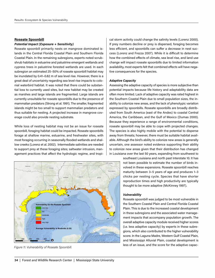
34 | Forest and Wildlife Research Center | Mississippi State University
Results: Ecosystem & Species Vulnerability
Roseate SpoonbillPotential Impact (Exposure + Sensitivity)Roseate spoonbill primarily nests on mangrove dominated is-lands in the Central Florida Coastal Plain and Southern Florida Coastal Plain. In the remaining subregions, experts noted scrub-shrub habitats in estuarine and palustrine emergent wetlands and cypress trees in palustrine forested wetlands are used. In each subregion an estimated 25–50% of roseate spoonbill habitat may be inundated by 0.41–0.82 m of sea level rise. However, there is a great deal of uncertainty regarding sea level rise impacts to colo-nial waterbird habitat. It was noted that there could be substan-tial loss to currently used sites, but new habitat may be created as marshes and large islands are fragmented. Large islands are currently unsuitable for roseate spoonbills due to the presence of mammalian predators (Strong et al. 1991). The smaller, fragmented islands might be too small to support mammalian predators and thus suitable for nesting. A projected increase in mangrove cov-erage could also provide nesting substrate.
While loss of nesting habitat may not be an issue for roseate spoonbill, foraging habitat could be impacted. Roseate spoonbills forage at shallow marine, estuarine, and freshwater sites, with most foraging occurring in seasonally flooded wetlands and shal-low creeks (Lorenz et al. 2002). Intermediate salinities are needed to support prey at these foraging sites; saltwater intrusion, man-agement practices that affect the hydrologic regime, and tropi-
cal storm activity could change the salinity levels (Lorenz 2000). If prey numbers decline or prey is dispersed, foraging becomes less efficient, and spoonbills can suffer a decrease in nest suc-cess (Lorenz and Frezza 2007). While it is difficult to determine how the combined effects of climate, sea level rise, and land use change will impact roseate spoonbills due to limited information availability, most experts felt that combined effects will have nega-tive consequences for the species.
Adaptive CapacityAssessing the adaptive capacity of species is more subjective than potential impacts because life history and adaptability data are often more limited. Lack of adaptive capacity was rated highest in the Southern Coastal Plain due to small population sizes, the in-ability to colonize new areas, and the lack of phenotypic variation expressed by spoonbills. Roseate spoonbills are broadly distrib-uted from South America (east of the Andes) to coastal Central America, the Caribbean, and the Gulf of Mexico (Dumas 2000). Because they experience a range of environmental conditions, roseate spoonbill may be able to cope with projected changes. The species is also highly mobile with the potential to disperse away from threats; however, there must be suitable habitat avail-able. Although the bird’s ability to colonize new areas is generally uncertain, one assessor noted evidence supporting their ability to colonize new areas given that their distribution has changed in Louisiana over the last 50 years, expanding from southwest to
southeast Louisiana and north past Interstate 10. It has not been possible to estimate the number of birds in-volved in these expansions. Roseate spoonbill reaches maturity between 3–5 years of age and produces 1–3 chicks per nesting cycle. Species that have shorter reproduction times and high productivity are typically thought to be more adaptive (McKinney 1997).
VulnerabilityRoseate spoonbill was judged to be most vulnerable in the Southern Coastal Plain and Central Florida Coastal Plain. This is due to the increased coastal development in these subregions and the associated water manage-ment impacts that accompany population growth. The overall adaptive capacity module received higher scores (i.e. less adaptive capacity) by experts in these subre-gions, which also contributed to the higher vulnerability score. In the Laguna Madre, Western Gulf Coastal Plain, and Mississippi Alluvial Plain, coastal development is less of an issue, and the score for the adaptive capac-
Figure 11. Vulnerability of Roseate Spoonbill.

Gulf Coast Vulnerability Assessment: Mangrove, Tidal Emergent Marsh, Barrier Islands, and Oyster Reef | 35
Results: Ecosystem & Species Vulnerability
ity module was lower in these subregions. Consequently, roseate spoonbill vulnerability was lower in these areas. Gulf-wide threats include changes to biotic interactions (specifically prey), loss of habitat to sea level rise and erosion, and storm surge.
As depicted in Figure 11, for each subregion, the vulnerability of roseate spoonbill was calculated by averaging the scores from the Potential Impact (exposure + sensitivity) and Adaptive Capacity modules. Scores in the Potential Impact and Adaptive Capacity modules were averaged across experts.
Tidal Emergent MarshEcosystem StatusAcross the Gulf, marsh acreage has been declining. Between 1998 and 2004, about 49,670 acres of freshwater emergent marsh and 44,090 acres of estuarine (brackish and salt) emergent marsh were lost along the Gulf Coast (Stedman and Dahl 2008). The highest freshwater marsh loss occurred from central Texas to Apalachicola, Florida. Loss of estuarine marsh was most notice-able in Texas, Louisiana, and Mississippi. NOAA (2010) indicated that wetlands across the Gulf of Mexico were primarily lost to open water (48%) and development (28%).
Potential Impact Sea level rise and erosion will result in the direct loss of marsh across the Gulf. However, SLAMM projections also show marsh migration inland into new areas, a phenomenon that is exacerbated as freshwater and brackish marsh be-come more suitable for salt marsh. Where shifts do occur, there may be a change in ecosystem function.
Direct loss to urban development was not judged to be a direct threat to marsh in most subregions. How-ever, in the Southern Coastal Plain, experts felt there could be some areas where development reduces tidal emergent marsh by 50–79%. Urbanization could also limit the ability for marsh to migrate inland.
Tidal emergent marsh in all subregions is likely to ex-perience fragmenting. It was noted by experts that fragmentation is particularly severe in the Mississippi Alluvial Plain where construction of the federal Mis-sissippi Rivers and Tributaries levee project has sub-stantially reduced sediment and freshwater delivery to the nearby wetlands. Subsequent work on freshwater diversions has attempted to reverse this by restoring
the supply of sediment needed to build land in the river deltas.
Experts across all subregions noted that tidal emergent marsh is already suffering from changes to the disturbance regime by way of altered river flooding cycles that have resulted in reduced sediment loading and freshwater inflow. Future changes to other disturbance regimes, such as tropical storm frequency and inten-sity and winter minimum temperature changes, will exacerbate marsh loss. Increased winter minimum temperatures may allow for the expansion of black mangrove into areas currently occu-pied by marsh. This is currently happening in stands of Spartina in the Laguna Madre and the West Gulf Coastal Plain. Potential increases in the frequency and intensity of hurricanes can cause rapid decreases in marsh area due to the complete submergence of marsh from storm surge and the breakdown of marsh from pounding surf (Palaneasu-Lovejoy et al. 2013).
Invasive species such as hydrilla, salvinia, water hyacinth, and nu-tria can negatively impact marsh systems, especially in freshwater marsh. In the Central Florida Coastal Plain, experts commented that invasive vegetation (mainly Brazilian pepper and Australian pines) encroach upon landward boundaries of salt marsh habi-tat, restricting landward migration in response to sea level rise.
VulnerabilityThe vulnerability of tidal emergent marsh is high across the entire
Figure 12. Vulnerability of Tidal Emergent Marsh.

36 | Forest and Wildlife Research Center | Mississippi State University
Results: Ecosystem & Species Vulnerability
Gulf Coast, except in the Southern Florida coastal plain where it is very high. Sea level rise, fragmentation of the ecosystem, altered hydrology, and constraints on range shift were typically judged to be the most serious threats across all subregions. In the Southern Florida Coastal Plain, these threats were judged to have severe negative impacts on marsh as compared to the other subregions.
As depicted in Figure 12, for each subregion, the vulnerability of tidal emergent marsh was calculated by averaging the scores from the Ecosystem Status and Potential Impact modules. Scores in the Ecosystem Status and Potential Impact modules were aver-aged across experts.
Blue CrabPotential Impact (Exposure + Sensitivity)Blue crab is not likely to be negatively affected by climate change, sea level rise, and land use change. As noted in the tidal marsh ecosystem assessment, marsh fragmentation is a major concern; however, blue crab uses marsh edge, which will increase with marsh fragmentation (Guillory et al. 2001). While there is the po-tential for “too much” edge, that threshold is currently unknown. As some marsh areas are converted to open water, blue crab may use submerged structures, such as oyster reefs, for cover. It was noted by experts that should salinity and SST change within the estuary, blue crab would potentially shift geographically to new areas where conditions become suitable.
Adaptive CapacityBlue crab was judged by experts to have the highest adaptive capacity of the 11 species assessed. Experts indicated the blue crab has high mobility, is widely distributed from North America to South America, and exists in large populations. They have high genetic diversity, with the larval population mixing near the con-tinental shelf (Ward 2012). Females lay up to 7 million eggs per brood (Graham et al. 2012). Larvae can be transported for dis-tances of 300 km or more, which enhances their ability to colonize new areas (Guillory et al. 2001). These characteristics support the ability to adapt to new environmental conditions by either migrat-ing away from threats or potentially adapting to new conditions.
VulnerabilityBlue crab vulnerability is low across all subregions. Their mobility and ability to tolerate a range of conditions are two characteristics that may be especially helpful in adapting to future conditions. Blue crab may also benefit from an increase in marsh edge (Zim-merman et al. 2000).
As depicted in Figure 13, for each subregion, the vulnerability of blue crab was calculated by averaging the scores from the Po-tential Impact (exposure + sensitivity) and Adaptive Capacity modules. Scores in the Potential Impact and Adaptive Capacity modules were averaged across experts.
Figure 13. Vulnerability of Blue Crab.

Gulf Coast Vulnerability Assessment: Mangrove, Tidal Emergent Marsh, Barrier Islands, and Oyster Reef | 37
Results: Ecosystem & Species Vulnerability
Clapper RailPotential Impact (Exposure + Sensitivity)Loss of tidal emergent marsh habitat was judged to be more se-vere in the Laguna Madre, Western Gulf Coastal Plain, Mississippi Alluvial Plain, and Southern Florida Coastal Plain. Experts noted that SLAMM models estimated that marsh accretion rates will keep up with sea level rise in the Southern Coastal Plain and the Central Florida Coastal Plain, but they questioned whether that was actually the case. In the Laguna Madre, Mississippi Alluvial Plain, and Southern Florida Coastal Plain, marsh fragmentation may negatively affect clapper rail’s dispersive potential and popu-lation connectivity.
Across the Gulf, a predicted increase in hurricane frequency and the associated storm surge pose a threat to the species. Experts commented that although adults may be able to survive storm surge conditions, nests that are located low on the vegetation in salt marsh are easily flooded. It was also noted that although immediate impacts may be negative, clapper rails might benefit from the ecological release from predation following storm events.
Some experts felt that potential changes in biotic interactions may negatively impact clapper rail. Reasons provided by the experts included increased encounters with predators as rails are pushed to their habitat limits; decreased availability of fiddler crabs, their main food source; and increased encounters with humans.
Adaptive CapacityCompared to other birds that were assessed, the clapper rail was judged to be less mobile. Assessors noted that while clapper rails possess the ability to migrate away from threats, they tend not to make large movements. Potential movement would also be limited by the availability of habitat. With the ex-
ception of the Laguna Madre and Southern Florida Coastal Plain, the clapper rail exists in large populations, which may enhance its ability to adapt to changes. However, it was noted that they are also strictly tied to their habitat, so migration may not be pos-sible if habitat is not available. Clapper rails show some regional variation in phenotypic traits. Assessors noted that while there is not much variation in habitat choice, bill lengths vary across the range and may allow for a prey shift. The clapper rail produces multiple eggs yearly; typically one of the young survives every year to every other year.
VulnerabilityClapper rail vulnerability varies from moderate to high. In the La-guna Madre, there are few clapper rails because tidal emergent marsh is limited in this subregion. Consequently, clapper rails may be more susceptible to projected threats and population fragmen-tation in this subregion. In the Southern Florida Coastal Plain, a subspecies of clapper rail occurs. Gulf-wide threats to clapper rail include loss of habitat to erosion and increased storm surge and hurricane frequency.
As depicted in Figure 14, for each subregion, the vulnerability of clapper rail was calculated by averaging the scores from the Potential Impact (exposure + sensitivity) and Adaptive Capacity modules. Scores in the Potential Impact and Adaptive Capacity modules were averaged across experts.
Figure 14. Vulnerability of Clapper Rail.

38 | Forest and Wildlife Research Center | Mississippi State University
Results: Ecosystem & Species Vulnerability
Mottled DuckPotential Impact (Exposure + Sensitivity)Tidal emergent marsh loss to sea level rise was judged to be an is-sue for mottled duck in the Western Gulf Coastal Plain, Mississippi Alluvial Plain, and Southern Coastal Plain. The marsh is already eroding in many of these areas, and sea level rise will compound the problem. In the other subregions, it was noted that mottled duck utilizes other habitat types more frequently. In Florida, most of the population is supported by freshwater emergent habitats, which may be lost as salinity increases because of saltwater in-trusion from sea level rise. In the Laguna Madre, information is limited regarding mottled duck nesting, but they likely use inland palustrine wetlands.
Across most of the subregions, precipitation changes will not likely impact mottled duck. However, experts note that the La-guna Madre subregion is semi-arid, and even a small decrease in precipitation could affect the availability of freshwater wetlands.
Although there is uncertainty regarding the synergistic effects of sea level rise, climate change, and land use change on mottled duck due to limited information availability, assessors agreed mot-tled duck will likely experience negative impacts due to interac-tions of these three drivers. Movement of humans away from the coast to inland peninsular Florida may have negative impacts on freshwater emergent wetlands because of development, pollution, and water usage. Assessors noted that introduction of the domes-
tic mallard could have negative effects on mottled duck through hybridization; an issue that is already occurring in Florida (Florida Fish and Wildlife Conservation Commission 2014).
Adaptive CapacityMottled ducks are highly mobile and utilize a variety of different habitats, so they will likely be able to disperse away from threats. However, suitable breeding habitat is found only along the Gulf Coast so the population is somewhat limited in its dispersibility. Assessors noted some regional variation in phenotypes. For ex-ample, in Florida mottled duck has adapted to urban landscapes, but this has not occurred in all of the subregions. Mottled duck may be able to cope with projected environmental changes, but there is uncertainty regarding how population size will be influ-enced. Experts estimated mottled duck to have intermediate to high genetic diversity. Species with high genetic diversity may possess some heritable traits that will allow them to cope with projected change (Bradshaw and Holzapfel 2006).
There are two populations of mottled duck along the Gulf Coast (Moorman and Gray 1994). One population is a resident of penin-sular Florida with an estimated 30,000 individuals, and the other population is resident from Alabama westward to Mexico. This population is estimated at 630,000 individuals (North American Waterfowl Management Plan, Plan Committee 2004). Expert re-sponses varied on the ability of mottled duck to colonize new ar-eas. Some felt only a few individuals would be capable of starting
a new population while others felt repeated introduc-tions with dozens of individuals would be necessary. VulnerabilityMottled duck was judged to be moderately vulnerable across the Gulf. In general, assessors thought that al-though the species may experience some negative impacts associated with climate and land use change, the population will probably not be strongly affected. The mottled duck’s demonstrated ability to adapt to a variety of habitats will likely contribute to the species’ ability to adjust to change.
As depicted in Figure 15, for each subregion, the vul-nerability of mottled duck was calculated by averaging the scores from the Potential Impact (exposure + sen-sitivity) and Adaptive Capacity modules. Scores in the Potential Impact and Adaptive Capacity modules were averaged across experts.
Figure 15. Vulnerability of Mottled Duck.

Gulf Coast Vulnerability Assessment: Mangrove, Tidal Emergent Marsh, Barrier Islands, and Oyster Reef | 39
Results: Ecosystem & Species Vulnerability
Spotted SeatroutPotential Impact (Exposure + Sensitivity)The GCVA associated spotted seatrout with tidal emergent marsh; however, many experts noted the fish’s use of submerged aquatic vegetation (SAV) and open water as habitat. SAV and open water may actually increase as a result of sea level rise. Marsh edge is also likely to increase as marsh becomes fragmented in response to sea level rise.
Projected temperature increases could potentially exceed thermal maximums for spotted seatrout. Optimum temperature for eggs and larvae was reported by Taniguchi (1980) to be 28°C, but the same study predicted 100% survival up to 32.7°C.
Very little spotted seatrout habitat is protected by conservation areas. Spotted seatrout are a popular recreational fishery. Conse-quently, lack of protected habitat free from fishing pressure may negatively affect the fish (Gell and Roberts 2003).
Adaptive CapacityThe ability of spotted seatrout to disperse away from future threats varied. In the Laguna Madre, Central Florida Coastal Plain, and Southern Florida Coastal Plain, experts felt the species could dis-perse from threats more than experts in the Western Gulf Coastal Plain, Mississippi Alluvial Plain, and Southern Coastal Plain. In Louisiana, there is some evidence that spotted seatrout movement varies by sex (Callihan et al. 2013). Females exhibit es-tuarine fidelity while males will leave their natal estuary and spawn in another area. Assessors think that spot-ted seatrout exhibit high genetic diversity, which can improve fitness. Most spotted seatrout reach maturity between years 2 and 3 (Etzold and Christmas 1979). Depending on size, a female can produce between 15,000 and 1,100,000 eggs. Assessors think that spotted seatrout show some regional variation in phenotypes, which will allow them to adapt to projected changes.
VulnerabilityVulnerability of spotted seatrout to future conditions ranged from low in the Laguna Madre, Central Florida Coastal Plain, and South-ern Florida Coastal Plain to moderate in the Western Gulf Coastal Plain, Mississippi Alluvial Plain, and Southern Coastal Plain. In subregions with moderate vulnerability, loss of habitat to sea level rise and erosion were judged to be more severe. Consequently, the limited ability of spotted seatrout to migrate away from threats in those subregions also increased vulnerability.
As depicted in Figure 16, for each subregion, the vulnerability of spotted seatrout was calculated by averaging the scores from the Potential Impact (exposure + sensitivity) and Adaptive Capacity modules. Scores in the Potential Impact and Adaptive Capacity modules were averaged across experts.
Figure 16. Vulnerability of spotted seatrout.

40 | Forest and Wildlife Research Center | Mississippi State University
Results: Ecosystem & Species Vulnerability
Oyster ReefEcosystem StatusThe percentage of oyster reefs considered to be functionally ex-tinct in the Gulf of Mexico was recently evaluated by Beck et al. (2011). In the Laguna Madre, West Gulf Coastal Plain, Mississippi Alluvial Plain, and Southern Coastal Plain, they estimated 50–89% of oyster reefs are functionally extinct. In the Central Florida Coastal Plain and Southern Florida Coastal Plain, oyster reef loss was estimated to be 90–99%. No estimates for Louisiana were given due to limited historic data.
Beck et al. (2011) classified oyster reef function in the Central and Southern Florida Coastal Plain as poor. Evidence indicates that the fishery is collapsing or collapsed, but the reefs still remain. In the remaining subregions, oyster reef function was classified as fair, abundance indicators were below 50% of historical figures, or records indicated greater than 50% loss in reefs, yet there was evidence of significant remaining reefs. Despite these declines, oyster reefs from the northern Gulf of Mexico still were estimated to provide average annual catch of over 50,000 tons of wild na-tive oysters, the largest quantity of any region in the world (Beck et al. 2011). Potential Impact Changes to the natural disturbance regime resulting from project-ed 2060 changes in climate, land use, and sea level will negatively affect oyster reefs, causing moderate decreases in extent and/
or ecosystem function. Salinity changes resulting from altered weather patterns are key, as are timing of increased or decreased precipitation. Small increases in sea surface temperature can also affect oyster growth and survival, largely through the interactive effects of low salinities with high temperatures, which can lead to increased mortality of individual oysters (Rybovich et al. 2016).
Changes in hydrology that affect salinity could negatively impact oyster reefs. Oysters that exist after marsh loss may experience ‘flashy’ hydrological conditions—higher highs and lower lows —because the buffering effect of marshes will no longer exist. Changes in salinity could affect predators and disease, as well as the ability of spat (larval oysters) to settle.
In response to projected changes, oyster reefs may be able to shift their distribution. However, this is dependent on several factors, in-cluding the availability of hard substrates within new areas, salin-ity changes, and lack of impediments. If suitable, new areas could be settled by larvae; however, the current reefs may be lost. In the Mississippi Alluvial Plain, Southern Coastal Plain, and Southern Florida Coastal Plain, experts judged coastal development to be a potential limitation to oysters’ ability to shift to new areas.
The harvesting of oyster reefs has been shown to greatly increase their vulnerability. Grabowski et al. (2012) indicate that vertical growth on unharvested oyster reefs, under the right conditions, can keep up with any estimated sea level rise, thus protecting the
species themselves as well as providing continued protection against shoreline erosion. In contrast, when harvested, the reefs are kept at low elevations and therefore may suffer from factors such as low dissolved oxygen and sedimentation.
VulnerabilityOyster reefs were judged to be highly vulnerable in all subre-gions, except the Southern Coastal Plain, where they are mod-erately vulnerable. In the Southern Coastal Plain, assessors noted there was not enough information to score several of the Potential Impacts criteria that affected the average vulner-ability score. Altered hydrology was judged to be the biggest threat to oyster reefs. The inability of the physical structures to migrate away from threats also increases their vulnerability.
As depicted in Figure 17, for each subregion, the vulnerability of oyster reef was calculated by averaging the scores from the Ecosystem Status and Potential Impact modules. Scores in the Ecosystem Status and Potential Impact modules were averaged across experts.Figure 17. Vulnerability of Oyster Reef.

Gulf Coast Vulnerability Assessment: Mangrove, Tidal Emergent Marsh, Barrier Islands, and Oyster Reef | 41
Results: Ecosystem & Species Vulnerability
Eastern OysterPotential Impact (Exposure + Sensitivity)The ability of an oyster reef to keep pace with sea level rise de-pends on whether reef recruitment and oyster growth, minus any removal from harvest, exceed sea level rise rates. Harvested reefs should be able to keep up with moderate sea level rise, if man-aged sustainably. Sustainable harvesting requires taking no more shells than necessary so that substrate exists for future settlement (Soniat et al. 2012).
The ranges of the projected changes in sea surface temperature (SST), salinity, and precipitation are likely to have subtle, and in many cases interactive effects on oyster recruitment, growth, and mortality (La Peyre et al. 2013). Experts were less concerned with environmental conditions exceeding physiological thresholds of oysters and more concerned with the potential increase in the presence of disease and predators associated with increased sa-linity and SST. Perkinsus marinus is a protist parasite that causes the disease known as dermo or perkinsosis in eastern oysters, causing massive mortality in oyster populations. Higher temper-atures and salinity are associated with major outbreaks (Soniat 1996). Predation by oyster drills (Urosalpinx cinerea) can decrease oyster populations. Oyster drills are dormant between 10° and 12.5°C, and are generally not found below salinity of 15 (Garton and Stickle 1980). Increase in SST and salinity could prolong the predators’ active period and range.
Potential increases in extreme conditions, such as in-creased frequency and severity of drought and flood cycles, could negatively affect oysters. Assessors noted that these impacts would be a direct result of oysters’ exposure to extreme ranges of their tolerance in tem-perature and salinity. Increasing drought conditions can result in hypersalinity, as has occurred in Texas, while flood cycles may increase freshwater input during spring and summer periods critical to oyster spawning (Pow-ell et al. 2003). If the floods reduce salinity significantly, spawning and recruitment may not occur during that year, affecting population dynamics. Sedimentation from runoff and storm surge can smoth-er reefs and is especially a risk to oyster reefs found in bays and enclosed areas. Runoff can also carry pollut-ants into estuaries and contribute to oyster mortality (Vanderkooy 2012).
Adaptive CapacityThe trait most limiting to the adaptive capacity of the eastern oyster is its limited ability to disperse away from potential threats. Oysters are more limited in their ability to disperse compared to other species that are mobile throughout most of their lifetimes. Assessors noted that rapid changes in environmental conditions would be deleterious for oysters; however, oysters probably could migrate away from a gradual shift in conditions as long as hard substrate is available for larvae. Another trait that enhances their adaptive capacity is their high fecundity rate. Oysters can produce two generations per year and an estimated range of 10–20 mil-lion eggs per spawn (Galstoff 1964). Oysters can also alter shell growth patterns based on substrate, temperature, current, turbid-ity, and pollution (Palmer and Carriker 1979). The ability to shift phenotypes suggests that oysters may be able to adjust to new environmental conditions. This could be especially useful in the presence of predators. The eastern oyster responds to the pres-ence of an oyster drill by allocating more resources toward shell growth (Lord 2014). Lastly, eastern oysters were scored as having high genetic diversity. A large gene pool increases the chances that a few individuals possess traits that will allow them to sur-vive new conditions.
VulnerabilityEastern oysters were judged to be moderately vulnerable across all subregions. The species assessment of eastern oysters in-
Figure 18. Vulnerability of Eastern Oyster.

42 | Forest and Wildlife Research Center | Mississippi State University
Results: Ecosystem & Species Vulnerability
dicates lower vulnerability than the ecosystem assessment be-cause it takes into consideration that oyster larvae are mobile and can colonize new areas if conditions are suitable. However, because the eastern oyster is also a commercially valuable spe-cies, this vulnerability ranking can be drastically altered if oys-ters are harvested unsustainably (Soniat et al. 2012). Gulf-wide threats to eastern oyster include changes to the natural hydro-logic regime and increased predation from oyster drills, which may benefit from high salinities.
As depicted in Figure 18, for each subregion, the vulnerability of eastern oyster was calculated by averaging the scores from the Potential Impact (exposure + sensitivity) and Adaptive Capacity modules. Scores in the Potential Impact and Adaptive Capacity modules were averaged across experts.
American OystercatcherPotential Impact (Exposure + Sensitivity)American oystercatcher vulnerability increases west to east in the Gulf. In Texas and Louisiana, American oystercatcher distribution is not surrounded by coastal development and natural barriers, so they should be able to move away from threats. Assessors identified storm surge as having negative impacts on American oystercatcher in all subregions, but the impact was more severe in the Southern Coastal Plain, Central Florida Coastal Plain, and Southern Florida Coastal Plain, than in the West Gulf Coastal Plain, Laguna Madre, and Mississippi Alluvial Plain. Although severity of
storm surge varied, the effects on American oystercatcher were similar across the Gulf Coast. Storm surge destroys nests and erodes nesting and roosting substrate. Storm surge could be es-pecially problematic for nesting birds if tropical storms increase in frequency or intensity or arrive earlier. Currently, tropical storms usually occur after nesting season.
Other threats to American oystercatcher include the loss of beach-nesting habitat, including man-made dredge spoil islands and oyster reef foraging areas, to erosion and sea level rise. Although there is uncertainty in how biotic interactions will change, most assessors think there will be a negative effect on American oys-tercatcher. Experts noted that should resources become more lim-ited, there could be increased competition with other birds such as laughing gulls. Prey availability may also be affected. Experts commented that laughing gulls, which will likely increase with the increasing human population, are also predators of American oystercatcher nests and young.
There is a great deal of uncertainty regarding how the combined effects of climate change, sea level rise, and land use change will affect American oystercatcher, although the overall impacts are thought to be negative. Synergistic combinations of sea level rise, erosion, storm surge, and coastal development are expected to reduce the amount of habitat available for American oystercatcher and may lead to local and even regional demographic shifts and severe population declines.
Changes in precipitation, temperature, and salinity may affect American oystercatcher prey but are not expect-ed to be direct threats to the birds.
Adaptive CapacityThe adaptive capacity of American oystercatcher var-ies across the Gulf; some of these differences could be due to insufficient information needed to answer some of the questions in the assessment. The entire East Coast population from New Jersey to Texas is estimated to be only about 11,000 individuals (Brown et al. 2005). Experts noted that the entire Gulf of Mexico American oystercatcher breeding population is estimated to be 700 individuals. These birds are solitary nesters, so at the local scale extirpation could be possible. Their gen-eration time is about 10 years, and they produce 2–3 eggs. Typically, only one chick will fledge.
Figure 19. Vulnerability of American Oystercatcher.

Gulf Coast Vulnerability Assessment: Mangrove, Tidal Emergent Marsh, Barrier Islands, and Oyster Reef | 43
Results: Ecosystem & Species Vulnerability
The species possesses the ability to disperse away from threats. However, they exhibit high nest and roosting site fidelity, so they may not adjust as well as a species that does not exhibit site fi-delity. Because they are broadly distributed from the Yucatan Peninsula to Long Island, they may be able to adjust to some en-vironmental changes.
VulnerabilityAmerican oystercatcher was judged to have moderate vulner-ability in the Laguna Madre, Western Gulf Coastal Plain, and Mississippi Alluvial Plain. In the Southern Coastal Plain, Central Florida Coastal Plain, and Southern Florida Coastal Plain, asses-sors judged the species to be highly vulnerable. In the three highly vulnerable subregions, increased vulnerability was due to barriers to dispersal, such as coastal development and shoreline armoring to prevent beach erosion. Gulf-wide threats include loss of nesting habitat to sea level rise and synergistic effects of climate change, sea level rise, and urbanization.
As depicted in Figure 19, for each subregion, the vulnerability of American oystercatcher was calculated by averaging the scores from the Potential Impact (exposure + sensitivity) and Adaptive Capacity modules. Scores in the Potential Impact and Adaptive Capacity modules were averaged across experts.
Red DrumPotential Impact (Exposure + Sensitivity)Across the Gulf Coast, red drum may be moderately im-pacted by future environmental conditions. As adults, they spend most of their time offshore, where spawn-ing occurs. Assessors think that open water habitat is likely to increase as a result of sea level rise. The great-est impacts are likely to occur in estuaries where larval and juvenile red drum seek shelter in the sea grass beds and marsh edges. Red drum abundance seems to be limited by total estuarine habitat (Yokel 1966). Conse-quently, loss of marsh and sea grass beds to sea level rise and erosion could negatively affect red drum. The lack of protected habitat is also a threat to this popu-lar recreational fishery. Protection of young fish in bays and estuaries may restore offshore spawning stock (Swingle 1987). Experts feel that projected changes in temperature, precipitation, and land use are not likely to impact the species.
Adaptive CapacityIn general, red drum characteristics will likely help them
cope with projected changes. Most assessors think the fish have high genetic diversity, which may increase fitness (Turner et al. 1999). Experts commented that geographically distinct popula-tions exhibit different life history strategies to cope with local conditions. Therefore, as the environment changes, red drum may be able to adapt to the new conditions. Assessors expect that red drum will have the ability to disperse from threats; however, there must be available nursery habitat. Adaptive capacity scores also reflected a difference in assessor opinion regarding genetic diver-sity and the phenotypic plasticity of red drum.
VulnerabilityRed drum vulnerability ranges from low to moderate across the Gulf Coast. Loss of habitat to sea level rise was not as severe in low vulnerability areas as compared to areas with moderate vul-nerability. In the Western Gulf Coastal Plain and Mississippi Allu-vial Plain, the loss of marsh habitat may decrease the dispersal of red drum, which increases vulnerability. In the Southern Coastal Plain, the overall vulnerability score was influenced by the rela-tively poor adaptive capacity scores that, as previously mentioned, reflected a difference in opinion among assessors.
As depicted in Figure 20, for each subregion, the vulnerability of red drum was calculated by averaging the scores from the Po-tential Impact (exposure + sensitivity) and Adaptive Capacity modules. Scores in the Potential Impact and Adaptive Capacity modules were averaged across experts.
Figure 20. Vulnerability of Red Drum.

44 | Forest and Wildlife Research Center | Mississippi State University
Results: Ecosystem & Species Vulnerability
Barrier IslandsEcosystem StatusBarrier islands in the Mississippi Alluvial Plain, Southern Coastal Plain, and West Gulf Coastal Plain subregions exhibit a complex pattern of landward or lateral migration as well as submergence (Rosati and Stone 2009). Overall island area has decreased, with documented losses of the Mississippi River delta plain barrier is-lands going back to the 1890s (McBride et al. 1992). Losses over similar periods of time have also been documented for the Missis-sippi-Alabama barrier islands (Morton et al. 2004, Morton 2008, Byrnes et al. 2013). In all of the subregions except for the Central Florida Coastal Plain, barrier island loss is likely to continue and surpass historical loss estimates.
Potential Impact Barrier island beaches and dunes will continue to be transformed by sea level rise in all subregions. Many factors will affect islands differently, including island sediment budgets, structural charac-teristics such as dune height and width, rate of local relative sea level rise, and anthropogenic influences such as beach nourish-ment. As a result, some islands will be submerged and fragment-ed, while others will be more resilient and migrate landward or otherwise persist (Fitzgerald et al. 2008).
Across the Gulf, barrier islands likely will be able to shift their distribution in some areas but will suffer some decreases in ex-
tent. The ability to keep pace with sea level rise depends on sedi-ment availability and decreases with higher rates of sea level rise (Fitzgerald 2008). For example, in the Mississippi Alluvial Plain where relative sea level rise rates are higher than in other areas of the Gulf, entire islands could become submerged.
Assessors scored land use change as having the greatest effects on barrier islands in the West Gulf Coastal Plain and Southern Coastal Plain. In both of these subregions, 30 – 49% of the bar-riers islands could be affected. All of the barrier islands may suf-fer from increased fragmentation due to the combined impacts of sea level rise and land use change. In a natural system, if the sediment supply is sufficient, the barrier island may retreat to-ward the mainland (“rollover”), maintaining its subaerial profile. Humans may indirectly impede this process through interruption of the sediment supply (e.g., jetties), or undertake direct efforts to stabilize an island in place (e.g., seawalls). In contrast, rates of ero-sion may be lowest and barrier island stability highest in areas that are maintained through sand nourishment (Morton et al. 2004).
The uncertainty in patterns and trends in tropical storm frequency and intensity leads to uncertainty surrounding how changes in disturbance regimes will impact barrier islands. Not all elements of the barrier island will respond in the same way. As previously mentioned, changes in storm frequency and a rise in sea level will alter amounts of upper beach vs. intertidal areas differently.
Lowered island elevations and increased overwash, for example, would in the short-term likely lead to in-creased habitat for Wilson’s plover and snowy plover, but total submergence would result in loss of all bar-rier island habitats. Precipitation has an impact on the vegetation cover of sand dunes. Decreased vegetation on sand dunes will impact the mobility of dunes and sedimentation at the barrier flats; changes in storm frequency will likely affect the types and spatial distri-bution of dune vegetation (Gornish and Miller 2010). Increased precipitation in the summer could supply the freshwater ponds within the barrier island, which are important sources of water and food for terrestrial vertebrates and birds.
VulnerabilityBarrier island vulnerability is moderate in the Laguna Madre subregion and high in the remaining four sub-regions in which they were assessed. Barrier islands were not assessed in the Southern Florida Coastal
Figure 21. Vulnerability of Barrier Islands.

Gulf Coast Vulnerability Assessment: Mangrove, Tidal Emergent Marsh, Barrier Islands, and Oyster Reef | 45
Results: Ecosystem & Species Vulnerability
Plain because the underlying geology, including the offshore pres-ence of coral reefs, is significantly different than islands through-out the rest of the Gulf. Vulnerability is lower in Laguna Madre because North Padre Island is protected, eliminating development as an issue. Although South Padre Island could be developed, the extent of development will not exceed 30% of the total barrier is-land. While sea level rise is a threat across all subregions, in La-guna Madre the assessor thought there were no range constraints limiting the ability of the barriers to migrate.
As depicted in Figure 21, for each subregion, the vulnerability of barrier islands was calculated by averaging the scores from the Ecosystem Status and Potential Impact modules. Scores in the Ecosystem Status and Potential Impact modules were averaged across experts.
Black Skimmer Potential Impact (Exposure + Sensitivity)The black skimmer nests on barrier beaches within all of the sub-regions except the Laguna Madre and West Gulf Coastal Plain. In these two subregions, assessors noted that black skimmers use natural and man-made islands within the bays to avoid ground predators that occur on the larger barrier islands. The natural beaches are already eroding in many areas, and sea level rise will compound the loss. With the exception of the Laguna Madre subregion and the barrier islands in Louisiana, coastal develop-ment is projected to further encroach on the species’ habitat. The resulting habitat fragmentation threatens black skimmer populations in the Mississippi Alluvial Plain, Southern Coastal Plain, Central Florida Coastal Plain, and Southern Florida Coastal Plain. In these ar-eas, breeding habitat is very limited so colonies may have lower productivity.
Projected increases in temperature may not affect adult birds, but could be limiting to eggs and chicks. Small changes in precipitation are unlikely to affect the spe-cies because they can handle brief, heavy rains as long as nests do not get over-washed. Storm surge attributed to tropical storm activity could be very detrimental to black skimmer, especially during the nesting season. Complete colony failure has been observed in the Gulf Coast region.
There is a great deal of uncertainty regarding how changes in biotic interactions due to sea level rise,
climate change, and land use change will affect black skimmer. Assessors think they will likely experience negative effects due to changes in prey abundance as well as increased competition with laughing gulls and brown pelicans for limited space and re-sources. Black skimmer may also be negatively affected by the combined effects of climate change, sea level rise, and land use change although information is limited.
Adaptive CapacityAcross the Gulf, skimmers live in populations ranging from 50 to more than 500. They are highly mobile with the ability to disperse away from threats if nesting sites are available. Although they show little phenotypic variation, they breed from New England to South America under a range of temperature and salinity re-gimes and may be able to cope with projected temperature and salinity changes.
VulnerabilityBlack skimmer vulnerability was judged to be the highest in the Southern Coastal Plain and Southern Florida Coastal Plain due to low adaptive capacity scores in these two subregions. Across all subregions, loss of habitat to sea level rise; impacts from storm surge and runoff; synergistic effects of climate change, sea level rise, and urbanization; and changes to the natural disturbance regime were scored as main threats.
Figure 22. Vulnerability of Black Skimmer.

46 | Forest and Wildlife Research Center | Mississippi State University
Results: Ecosystem & Species Vulnerability
As depicted in Figure 22, for each subregion, the vulnerability of black skimmer was calculated by averaging the scores from the Potential Impact (exposure + sensitivity) and Adaptive Capacity modules. Scores in the Potential Impact and Adaptive Capacity modules were averaged across experts.
Kemp’s Ridley Sea TurtlePotential Impact (Exposure + Sensitivity)Kemp’s ridley may be particularly vulnerable to sea level rise be-cause about half of them nest on barrier island beaches, which as previously noted are highly vulnerable across much of the Gulf region. Assessors noted that as this nesting habitat decreases, mainland beaches could be used for nesting; however, coastal development then becomes a greater threat. During tropical storms, nests are subject to inundation and washout from high tides, increased wave action, and heavy rainfall; therefore, in-creases in storm or rainfall frequency or intensity were judged to negatively affect this species. Because sex determination is temperature-dependent for this species, the projected increase in temperatures could affect hatchling sex ratios. At 30°C, nests are male dominated while a temperature of 32°C produces 100% females (LeBlanc 2012). Temperatures that are higher than 32°C may cause complete nest mortality.
More indirect effects of climate and land use change are harder to assess due to limited data. Assessors commented that crab
populations are the primary prey item of Kemp’s ridley and some species could be negatively impacted; however, Kemp’s ridley are highly migratory, have a varied diet, and may therefore find alternate prey. Increased human disturbance on land and in the water coupled with increased disease and bacterial infections due to increased water temperature may also prove detrimental. Increased urbanization could also lead to increases in mammalian predators such as coyotes and raccoons. Assessors noted that predators are a threat in some areas, such as Little St. George Island in Florida, where, for example, loggerhead nest loss can be >80% some years due to coyote predation. Kemp’s ridley sea turtles nest in mass events called “arribadas.” This may reduce impacts from predation, provided there is a sufficient quantity of nesters, because predators cannot locate individual nests by scent (Eckrich and Owens 1995).
Adaptive CapacityOf the species assessed, Kemp’s ridley was judged to have the lowest adaptive capacity. They exhibit some nest site fidelity com-pared to other species that were assessed, so they may be less likely than other species to migrate away from threats. The entire population nests within the Gulf of Mexico, mostly along the coast of Mexico although nest sites have spread north and south of the Mexico beaches. Experts indicated that Kemp’s ridley shows low to zero phenotypic plasticity, a trait that could potentially allow them to adjust to the environmental conditions they experience
(Fordyce 2006). Kemp’s ridley have very low genetic variation after drastically declining during the mid-1900s. Experts noted that in 1985, there were only 702 recorded nests, compared to an estimated 40,000 in one day in 1947. The age of first reproduction is es-timated to be between 10 and 15 years of age, after which females produce 2.5 nests biannually with an average of 90 eggs per nest.
VulnerabilityKemp’s ridley were only assessed in the three subre-gions in which they most commonly nest, although nesting in other areas of the U.S. portion of the Gulf Coast does occur. In these three subregions, Kemp’s ridley were identified as the most vulnerable species out of the eleven evaluated. Kemp’s ridley may be sen-sitive to habitat loss from urban development and sea level rise. Increasing temperatures could also cause shifts in sex ratios.
Figure 23. Vulnerability of Kemp’s Ridley Sea Turtle. .

Gulf Coast Vulnerability Assessment: Mangrove, Tidal Emergent Marsh, Barrier Islands, and Oyster Reef | 47
Results: Ecosystem & Species Vulnerability
As depicted in Figure 23, for each subregion, the vulnerability of Kemp’s ridley sea turtle was calculated by averaging the scores from the Potential Impact (exposure + sensitivity) and Adaptive Capacity modules. Scores in the Potential Impact and Adaptive Capacity modules were averaged across experts.
Wilson’s Plover Potential Impact (Exposure + Sensitivity)Across the Gulf, Wilson’s plovers inhabit highly erosive, sandy beaches that are already disappearing in Texas and Louisiana. Sea level rise will exacerbate the loss of this habitat. Assessors in the Laguna Madre, Southern Coastal Plain, and Southern Florida Coastal Plain judge increasing temperatures to negatively impact the species. Although the species has broad latitudinal accep-tance, higher temperatures may exacerbate stresses to eggs and chicks (Ogden et al. 2014). Possible increases in storm surge and changes to the disturbance regime were judged to negatively im-pact Wilson’s plover during breeding season.
Changes in biotic interactions were judged by to have negative effects on the species. Experts commented that human distur-bance of nesting sites will increase in many areas of the Gulf Coast as coastal development and human traffic increases. It was also noted that as beaches become more limited, there will be more competition for nesting space with other species of shorebirds and seabirds. Fiddler crabs, which are the main food source for Wilson’s plover, may decrease in availability due to in-creased salinity. Adaptive CapacityWilson’s plover are a highly mobile, broadly distributed species. However, they occupy a very specific habitat; narrow beaches. The Gulf Coast population is estimat-ed to contain 3,000–3,200 breeding pairs (Zdravkovic 2013). Information regarding genetic diversity and phe-notypic plasticity is limited, but assessors noted that the species does occupy a large range and consume differ-ent prey, indicating there may be some regional varia-tion. Wilson’s plovers produce 1–2 chicks per year, with the first breeding occurring in the spring following the hatch year (Zdravkovic 2013). Compared to other birds assessed, assessors think Wilson’s plover can colonize new areas with a relatively low number of birds (repeat-ed invasions of approximately 10 birds).
VulnerabilityWilson’s plover vulnerability was judged to be high in the Southern Coastal Plain, Central Florida Coastal Plain, and Southern Florida Coastal Plain. In the remaining subregions, vulnerability is moder-ate. Wilson’s plover had the highest potential impacts score in the Southern Coastal Plain, which resulted in high vulnerability. In the Central and Southern Florida Coastal Plains, high vulnerability is due to low adaptive capacity. The loss of habitat to sea level rise; impacts from storm surge and runoff; and the synergistic effects of climate change, sea level rise, urbanization, and changes to the natural disturbance regime, were scored as the main threats across all subregions.
As depicted in Figure 24, for each subregion, the vulnerability of Wilson’s plover was calculated by averaging the scores from the potential impact (exposure + sensitivity) and adaptive capacity modules. Scores in the potential impact and adaptive capacity modules were averaged across experts.
Figure 24. Vulnerability of Wilson's Plover.

48 | Forest and Wildlife Research Center | Mississippi State University
R eflecting on the lessons learned from the GCVA can improve future efforts. The lessons learned in this study reflect on the approach, the SIVVA tool, scale, data, and species and
ecosytem selection.
ApproachThe Ecosystem and Species Expert Teams (ESET) were organized by ecosystem, with a single lead coordinating assessments for both the ecosystem itself and the associated species. Use of spe-cies team leads in addition to ecosystem leads, may have enabled the Assessment Team to tap into different groups when search-ing for assessors. In addition, the voluntary nature of the team lead position for each ESET limited the time available for finding assessors and aiding with any technical difficulties encountered in completing the assessments. Identifying species team leads would allow all the leads more time to focus on their particular areas of expertise. Because of time constraints, email contact was the primary form of communication. Contact through a peer rather than ‘cold-calling’ experts may have improved the response rate.
Assessors completed the assessments independently, which enabled the Assessment Team to document different points of view without one opinion influencing others, but it was also time consuming when it came to compiling the assessment results. The option of using a workshop setting (either in person or via a teleconference) to complete the assessments was discussed. A workshop could be a time-effective way to gather expert input and can reduce interpretation discrepancies among assessors. It also allows for discussion of results with the facilitator of the vul-nerability assessment in a group setting. However, coordinating workshops requires additional funds and the time of the experts. Coordinating workshops during interest group meetings and relevant conferences should be considered in future efforts as a means to gather input more efficiently.
Assessors also commented that they are frequently solicited for their input and expertise in assessments, but do not see concrete examples of how they are going to be used or get feedback on how it was used. Stating very clearly what the assessment will be used for (specifically, not in a general sense of informing restora-tion) and sending assessors a copy of the report may help allevi-ate 'assessment fatigue.’
The SIVVA ToolAssessors were asked to assess vulnerability based on their inter-pretation of model outputs and their personal knowledge. While this qualitative approach suited our time and budget, a more quantitative approach that directly incorporates physical and ecological models would have reduced some of the uncertainty and variation in expert judgement. An assessment that uses GIS as its main tool offers promise not only due to the capacity of GIS to manage large datasets but also because GIS would support spatial and statistical analyses relevant to the assessment of vul-nerabilities with spatial footprints. However, well-informed expert opinion has been shown to accurately assess risk relative to strict-ly quantitative modelling approaches in many cases (Clevenger et al. 2002, Johnson and Gillingham 2004), particularly where high resolution spatial data are lacking.
Assessors of the aquatic species commented that SIVVA is more suited for terrestrial species. Additional criteria that addressed issues like fishing pressure, water quality, currents, and ocean acidification would have been beneficial for determining aquatic species vulnerability. There is currently no vulnerability assess-ment available that specifically targets aquatic species; however, there are tools available that may facilitate the development of an aquatic vulnerability assessment. These include: • OceanAdapt was developed by the Rutgers School of Environ-
mental and Biological Sciences and the National Marine Fish-eries Service to explore the impacts of climate change and oth-er factors on marine life. The OceanAdapt online tool provides information about the impacts of changing climate and other factors on the distribution of marine life to the National Climate Assessment, fisheries communities, and policymakers.13
• Aquamaps is a joint project of FishBase and SealifeBase. Aqua-Maps is an approach to generating model-based, large-scale predictions of marine species’ occurrences based on known locations. The ultimate objective is to infer species distributions from this data to replace the rough, hand-drawn maps that are currently most commonly used to depict known areas of spe-cies' presence. Aquamaps provides, in addition to the current distribution map, a suitable map and a scenario for the species distribution in 2100.14
• Species Range Shift Wizard was developed by The Nature Conservancy in collaboration with Environment Canada and
5. LESSONS LEARNED
13 This tool is available online at: http://oceanadapt.rutgers.edu/ 14 This tool is available online at: http://aquamaps.org/

Gulf Coast Vulnerability Assessment: Mangrove, Tidal Emergent Marsh, Barrier Islands, and Oyster Reef | 49
Lessons Learned
the University of Washington to map changes in species dis-tributions using projected changes in the areas likely to be cli-matically suitable for individual species. Projections are derived from niche models that relate a single species’ distributions to recent climatic conditions. These models are then applied to projected future climatic conditions to determine what areas will likely be climatically suitable for a species in the future.15
SIVVA does not have a predefined vulnerability ranking, so the user can dictate the qualitative descriptions (e.g. high vulner-ability) and the range of values associated with each of those descriptions. Future assessments could aim to statistically justify rankings or better describe what various vulnerability levels cor-respond to. For example NatureServe’s Climate Change Vulner-ability Index describes moderate vulnerability as the “abundance and/or range extent within geographical area assessed likely to decrease by 2050.” Within the GCVA, the same rankings were used for each assessment type (species and ecosystems) even though the two assessments have different modules. This may explain why some moderately vulnerable species were associated with highly vulnerable ecosystems, since the ecosystem assessment did not explicitly account for adaptive capacity.
ScaleWhen conducting a vulnerability assessment, choosing the cor-rect spatial scale for the assessment tool is important. The GCVA assessed how vulnerability varied across the Gulf, but logistical considerations related to the availability of data and reviewers limited the number of subregions. The spatial scale of these sub-regions did detect differences in vulnerability; however, future assessments could identify input data more appropriate for as-sessing vulnerability at finer spatial scales. For oyster reefs, the salinity and water temperature projections were the same for the entire study area, so answers did not vary for the subregions. However, for ecosystems at risk of inundation due to sea level rise, treating the areas independently was useful. Additionally, the scales of the terrestrial systems and marine systems vary greatly. Although a bay or estuary could be considered for analysis pur-poses as a whole system, if the nearshore or offshore environment are to be included in future assessments a mesoscale could be more suitable.
Incorporating the temporal scale of the data could also be ben-eficial for future assessments. Because species (particularly mi-gratory species) use a variety of habitats over time, time series of some variables would be desirable to include in future assess-ments. For a review of how to select the proper scale for vulner-ability assessments, see Friggens et al. (2013).
Data Higher spatial resolution data would have improved the usefulness of the map layers that were provided to assessors. While gener-ating map layers to show projected changes in air temperature and precipitation may be more time consuming, such maps would have been easier for assessors to interpret than the graphs pro-vided. Species distribution maps were provided for Kemp’s ridley nests, oyster reefs, and blue crab, while less detailed range maps were used for most of the other species. Distribution maps would have been a better fit with the resolution of the SLAMM map layer; however, these maps were not available for many species.
There were also large gaps in the SLAMM data, which made es-timating habitat loss difficult in some areas. However, Gulf-wide SLAMM analysis is now available that includes predictive mod-eling of seaside sparrow, mottled duck, and black skimmer (see Section 7 for more information). The results of that work were not completed when the subject matter experts began their delibera-tions for the GCVA, but they are now available (Warren Pinnacle Consulting 2015b).
Species and Ecosystem SelectionA single set of species was chosen for all subregions across the spatial extent of the assessment. These species were chosen in part as indicators of ecosystem health, i.e. as proxies for all spe-cies that utilize the habitats in a similar way. The decision to use a single set of species was made in the interest of consistency; however, some of the species chosen did not use all of the regions in the same way, or at all. For example, black skimmer in Texas use man-made islands in sheltered regions rather than barrier islands, and Kemp’s ridley do not nest throughout the entire Gulf region. An alternate strategy would be to use widespread species where possible but substitute local species to capture regional differences in habitat usage, so that consistency is maintained in the scope of the evaluation rather than for the species. Another
15 This tool is available online at: http://maps.esri.com/SP_DEMOS/speciesmapper/
50 | Forest and Wildlife Research Center | Mississippi State University
LESSONS LEARNED
strategy would be to include targets that are specific/relevant to a subregion (as other plans have done) but that are part of the same functional group, such as one target shorebird in Texas and one in Florida.
In some ecosystems, the breadth of habitats represented within the ecosystem complicated the assessment. The focus of this report was on barrier island beaches and dunes, but each of the different habitats within barrier islands (e.g., upper beach, lower beach, dune, and intertidal) may respond differently under the projected changes and are used differently by various species. Assessing the beaches and dunes as one entity is a necessary limitation for this assessment, and the results are presented in light of this. Future vulnerability assessments could identify spe-cific sub-habitats for a specific stage of a species’ life.
For oyster reefs, there was no distinction made between harvest-ed and unharvested reefs. One assessor noted that harvested reefs may not handle stress as well as unharvested ones, and this should be considered for future assessments. Similarly, for some birds, both breeding and non-breeding populations resided in the same subregion. It was noted by some assessors that vulnerability would be different between the two populations.
Reviewers of the GCVA and audience members to GCVA presen-tations showed interest in expanding the assessment to include other species and ecosystems, particularly submersed aquatic vegetation (SAV). This should be considered in future assess-ments.

Gulf Coast Vulnerability Assessment: Mangrove, Tidal Emergent Marsh, Barrier Islands, and Oyster Reef | 51
One of the benefits of expert elicitation exercises is that they can be used to identify areas of uncertainty and thus highlight monitoring and data needs (Knol et al. 2010).
The application of SIVVA allows the user to identify situations where there is not enough information available to answer the question. These responses can then be used to identify where
more research is needed. Tables 2 and 3 show criteria for which at least one expert felt there was not enough information to assign a score. It is important to note that there may be studies that address some of these data gaps for other areas; however, this section reflects potential data gaps for the Gulf Coast region as identified by the assessors.
6. UNCERTAINTIES & POTENTIAL FUTURE RESEARCH
Table 2: Summary of information needs for species* Ameri-
can oyster-catcher
Wilson's plover
black skimmer
Kemp's Ridley
mottled duck red drum
spotted seatrout blue crab
clapper rail
eastern oyster
roseate spoonbill
Sea Level Rise x x x x x x
Erosion x x x x
Barriers x x x x x
Temperature x x x x x
Rain x x
Protection
Fragmentation x x x x x
Increased Salinity x x
Runoff x x
Biotic Interactions x x x x x x x x
Effect of Projections x x x x x x x x x x
Disturbance Regime x x x x x x x x
Habitat Tracking x x x
Phenotypic Plasticity x x x x x x x x
Genetic Diversity x x x x x x x x
Adaptive Rate x
Migration Adpatation x x x
Life History x x x x x x x x x
Endemism
Populations
Keystone Species x x
Distinctiveness x x x x
Provider
Federal Listing
Recovery Success x
Information Available x
Demographic Models x x x
Genetic Data x x x x x x x
Response to SLR x x x x x x x x x x x
Climate Change x x x x x x x x x x x
*An x indicates at least one assessor scored the criterion as a 0. If the criteria were within the SIVVA information availability module, an x indicates a score of 0 or a 1 was assigned.

52 | Forest and Wildlife Research Center | Mississippi State University
UNCERTAINTIES & POTENTIAL FUTURE RESEARCH
Table 3: Summary of information needs for habitats*
Barrier Islands Mangroves Oyster Reef Tidal Emergent Marsh
Land loss 50 years x x
Land Decline 1750 x x x
Predicted land decline x x x x
Function decline 50 years x x x
Function decline since 1750 x x x x
Function predicted decline x x x x
Total extent x
Area of occupancy x x x x
Total acreage x x x x
Sea level rise x
Urbanization x
Fragmentation x x
Disturbance x x x
Hydrology x x
Invasive species x
Range shifts x
Abiotic factors x x x
Biotic interaction x x x x
Endemism x
Endemic species x x x
Ecosystem service x
G score
S score x x x x
*An x indicates at least one assessor scored the criterion as a 0.

Gulf Coast Vulnerability Assessment: Mangrove, Tidal Emergent Marsh, Barrier Islands, and Oyster Reef | 53
UNCERTAINTIES & POTENTIAL FUTURE RESEARCH
Lack of information regarding impacts from projected changes in disturbance regimes, biotic interactions, and synergistic effects were commonly cited in both the species and ecosystem assess-ments. Many of the species assessments also indicated there is a lack of information detailing genetic information, phenotypic plas-ticity, life history, and species responses to past climate change and sea level rise.
Many assessors found it difficult to assess the combined effects of sea level rise, land use change, and climate change on spe-cies and ecosystems. There are very few studies that detect non-independent effects of more than one variable related to climate change (Harley et al. 2006). Usually, combined effects cannot be predicted based on the individual effect of each variable. One fac-tor may be strengthened or weakened by changes to another fac-tor, or the two factors may act together and push an individual or population beyond a threshold. Research is needed to determine how the variables interact. Assessors also had a difficult time scoring how biotic interac-tions may change. Since the sensitivity of individual species to projected threats is likely to vary, there could be changes to com-munity structure and composition as species interactions such as predator-prey relationships, mutualisms, and competition are impacted (Hartley et al. 2010). Most studies focus on change at the individual level because manipulating and measuring re-sponses at higher levels of biological organization is difficult. More comprehensive models are needed such as NOAA’s Integrated Ecosystem Assessment framework, which is available for ocean management and implemented by the National Marine Fisheries Service (Levin et al. 2009).
Uncertainty pertaining to changes in the disturbance regime, particularly regarding tropical storms, was commonly cited by assessors. Tropical storms are an important aspect of coastal ecosystems. The average return period of hurricanes for many locations along the Gulf Coast is 8 – 11 years (NHC 2015), and individual storms can have significant and long-lasting impacts on coastal ecosystems. Results are often conflicting regarding changes in tropical storm regimes because large fluctuations in
the frequency and intensity of tropical storms complicate the de-tection of long-term trends and their relationship to rising levels of atmospheric greenhouse gases (Knutson et al. 2010). Limited availability of global historical tropical storm records makes it hard to determine whether past changes in tropical storm activity have exceeded the variability expected from natural causes.
Genetic information, phenotypic plasticity, and life-history data are factors that help determine the adaptive capacity of species. Genetic data are often missing for species; however, it is impor-tant to know because high levels of genetic variation within natural populations improve the potential to withstand and adapt to new environmental changes (Nicotra et al. 2010). Phenotypic plastic-ity is the ability of individuals to modify their behavior, morphol-ogy, or physiology in response to new environmental conditions (Bradshaw and Holzapfel 2008).
Many assessors were unaware of existing demographic or niche models for target species. For some species such as the blue crab and American oystercatcher, experts noted models were available for other geographic regions but not the Gulf Coast re-gion. Demographic models identify life history stages critical to population persistence, which is an important part of evaluating a species’ adaptive capacity. Niche-based models take the climatic conditions of a species' current distribution and use modeled fu-ture climate scenarios to project future distributions. These are important for assessing the exposure aspect of vulnerability. An example of a management/modeling tool for the implementation of an integrated approach is the model Atlantis (Kaplan et al. 2010, Ainsworth 2011).
Most assessors indicated they were unaware of data regarding species responses to past sea level rise and climate change. These data are important because during some historic periods climate change and sea level rise were as severe and rapid as those pro-jected for the future (Dawson et al. 2011). Paleo-ecological records for different taxa and life history types can be used as an example of past responses that may be likely in the future.

54 | Forest and Wildlife Research Center | Mississippi State University
T he GCVA contributes to the larger Southeast Conservation Adaptation Strategy (SECAS), which was initiated by the Directors of the Southeastern Association of Fish & Wildlife
Agencies (SEAFWA) and members of the Southeast Natural Resource Leaders Group (SENRLG) to provide a broader spatial and temporal context for conservation across the Southeast.
Climate change impacts occur at scales much larger than the boundaries within which organizations and agencies typically operate. The landscape view of vulnerability and threats to Gulf of Mexico species and ecosystems captured by the GCVA allows for regional coordination of adaptive management plans, which has the potential to maximize the efficacy of limited funding for conservation. Across the Gulf, there are countless projects that, taken individually, may not be effective in achieving landscape scale conservation objectives but have the potential to be connected in a way that accomplishes the larger goal of Gulf Coast sustainability. The results from the GCVA can be used in conjunction with these projects to identify where management actions should be focused to address vulnerable species and ecosystems.
State Wildlife Action Plans (SWAP) are one example of efforts that can be used in coordination with results from the GCVA. These plans identify Species of Greatest Conservation Need (SGCN), conservation threats, conservation actions, and research needs. In their Best Practices for State Wildlife Action Plans, the Association of Fish and Wildlife Agencies (AFWA 2012) urges states to follow the recommendations outlined in their Voluntary Guidance for States to Incorporate Climate Change into State Wildlife Action Plans and Other Management Plans (AFWA 2009). These recommendations include use of climate change as one of the criteria for selecting SGCN as well as the need to conduct vulnerability assessments to inform actions. The GCVA can be used both to inform conservation actions and link individual actions in support of regional conservation and adaptation efforts by:
1) Identifying vulnerable species and ecosystems across the Gulf region In the situation where multiple states identify a species as highly vulnerable, allocation of resources to support that Gulf-wide “most vulnerable” species could potentially benefit multiple jurisdictions
and increase the effectiveness of an individual State’s actions (National Fish, Wildlife and Plants Climate Adaptation Partnership 2012). For example, Kemp’s ridley sea turtles are federally listed as endangered and are designated as a SGCN by all five Gulf States. Kemp’s ridley was also identified as the most vulnerable species assessed by the GCVA. Threats to Kemp’s ridley as identified through SWAPs and the GCVA include nesting habitat loss because of sea level rise and erosion, dispersal barriers due to coastal development, and human disturbance. Because Kemp’s ridley nest primarily in Mexico with about 1% on the Texas coast in the U.S., management actions that are more directed toward nesting habitat may be more beneficial in Texas and nearby areas that may become suitable as conditions changes. Across foraging areas in all states, experts for the GCVA noted bycatch mortality as a major issue impacting Kemp’s ridley. Therefore, it is logical that regional efforts promoting the use of turtle-excluder devices (TEDs) would be most effective if implemented Gulf-wide as opposed to in one or two States.
2) Identifying the most common threats to species and ecosystemsIdentifying the threats that potentially impact the most species and ecosystems, and then focusing on management actions to specifically address those threats may increase the effectiveness of limited resources. For instance, sea level rise, erosion, and altered hydrologic regimes are commonly listed as the main threats to ecosystems and species in both SWAPs and the GCVA; therefore, management actions that address these threats will benefit multiple resources. Because ecosystems and the distribution and movement of species are not limited by political boundaries, movement and migration across borders occurs. Therefore, it is important to make sure that as species move from one area to the next, the habitat is maintained (National Fish, Wildlife and Plants Climate Adaptation Partnership 2012). Continued and improved coordination among partners across the Gulf Coast region to address common threats can help ensure that actions in one area build on actions in another, thus providing the greatest benefit to wildlife (National Fish, Wildlife and Plants Climate Adaptation Partnership 2012). 3) Identifying research gapsIdentifying information needs and uncertainties, as in section 6 of this GCVA, is essential to developing the targeted research that
7. SETTING THE STAGE FOR ADAPTATION
Gulf Coast Vulnerability Assessment: Mangrove, Tidal Emergent Marsh, Barrier Islands, and Oyster Reef | 55
SETTING THE STAGE FOR ADAPTATION
is needed to address knowledge gaps. The areas of uncertainty identified by expert assessors can be combined with the information gaps revealed through other projects to indicate where there is substantial uncertainty, informing where to focus limited research resources. Funding of research projects that target areas of uncertainty common to the entire Gulf Coast region or that address the major threats with high uncertainty are two ways to make the most of limited funds.
4) Re-evaluating vulnerability as new data become availableThe approach used by the GCVA can be quickly and easily updated as new data become available, so natural resource managers can make informed decisions based on the best available science. For example, concurrent to the activities of the GCVA, the Gulf Coast Prairie Landscape Conservation Cooperative commissioned Warren Pinnacle Consulting to conduct a SLAMM analysis for the full U.S. Gulf of Mexico coast (Warren Pinnacle Consulting 2015b). A part of that analysis also included predictive modeling of several focal species; specifically, seaside sparrow (Ammodramus maritimus), mottled duck, and black skimmer. This work fulfills the identified need to fill the gaps in the EPA/GOMA/NWF/USFWS SLAMM inventory shown in Figure 6, which was performed using different SLAMM versions under different environmental assumptions or model capacities to handle those assumptions (e.g., different ways to handle spatially-variable marsh subsidence). The results of the new Warren Pinnacle (Warren Pinnacle 2015b) work were completed after the subject matter experts began their deliberations for the GCVA but can be incorporated into the existing assessments.
General Adaptation StrategiesStein et al. (2014) in their Climate-Smart Conservation: Putting Adaptation Principles into Practice offer guidance for designing and carrying out conservation in the face of a rapidly changing climate. The document describes seven general strategies that can be employed by managers for adaptation and/or conservation plans (pp. 121). The ecosystem and species experts involved in this GCVA identified a number of management strategies that could be used as part of the following four general adaptation strategies identified by Stein et al. (2014) as follows: 1) Reduce non-climate stresses: Educating the public about the consequences of disturbing nesting and foraging birds and posting signs to delineate a protective
buffer zone around foraging, nesting, and loafing areas can reduce stress on these species (Florida Fish and Wildlife Conservation Commission 2013). Preventing overfishing/overharvesting of popular fisheries such as blue crab, red drum, spotted seatrout and oysters is important and can be achieved by monitoring fish populations and adjusting regulations as needed (Atlantic States Marine Fisheries Commission). For blue crab and Kemp’s ridley sea turtle, actions that reduce bycatch mortality are needed. Blue crabs often die after being captured in shrimp gear. Using salt boxes to separate blue crab from shrimp can improve blue crab survival (Guillory 2001). Requiring TEDs may help alleviate Kemp’s ridley sea turtle bycatch mortality, especially when used in conjunction with fishery closings that coincide with time periods when turtle density is greatest (Lewison et al. 2003)
2) Protect key ecosystem features: Areas that are currently on the threshold of suitability should be considered for restoration. For example, oyster reefs with marginal water quality could be targeted for habitat restoration to promote future population growth or recruitment in extreme years when isohalines have moved up or down estuary.
3) Restore structure and function: Freshwater from rivers and streams supplies nutrients and sediments and regulates salinity levels in coastal environments. Human activities, such as dam construction, river diversions, levee building, and water usage, can interfere with the amount and timing of freshwater delivery (Reed et al. 2012). Watershed management should make sure the seasonality, volume, and biogeochemical needs of the downstream ecosystems are met (Sklar and Browder 1998). To accomplish this, research is needed to determine environmental tolerance ranges, including the interactive effects of parameters for estuarine species, and to understand the significance of ecological patterns and geochemical processes (Sklar and Browder 1998).
4) Protect refugia: Marine reserves are designated areas of the sea where fishing is not allowed. These reserves provide refuge for populations of exploited species and allow habitats modified by fishing to regenerate (Gell and Roberts 2003). Establishing protected reef areas, which may provide source larvae, can benefit oysters. Locations should be determined through waterflow modeling to ensure the larvae spawned are recruited to current habitats.

56 | Forest and Wildlife Research Center | Mississippi State University
SETTING THE STAGE FOR ADAPTATION
The GCVA sets the stage for further development of adaptation strategies to ensure conservation of the biological, cultural, economic, and recreational resources of the Gulf Coast. Although specific management actions should be based on local conditions, the GCVA can inform the decision-making process to ensure the conservation and restoration of areas and species focus on those that are most vulnerable, most responsive to action, and most
limiting. Advancing coordinated, Gulf-wide conservation efforts that supersede political and administrative boundaries is needed to ensure the long term sustainability of the Gulf region, which will have far-reaching impacts for both wildlife and humans.

Gulf Coast Vulnerability Assessment: Mangrove, Tidal Emergent Marsh, Barrier Islands, and Oyster Reef | 57
LITERATURE CITED
Aguilar R., A.H. Hines, T.G. Wolcott, D.L. Wolcott, M.A. Kramer, R.N. Lipcius. 2005. The timing and route of movement and migration of post-copulatory female blue crabs, Callinectes sapidus Rathbun, from the upper Chesapeake Bay. J. Exp. Mar. Biol. Ecol. 319, 117-128.
Ainsworth, C.H., J.F. Samhouri, T.S. Busch, W.L.L. Cheung, J. Dunne, T.A. Okey. 2011. Potential impacts of climate change on Northeast Pacific marine foodwebs and fisheries. ICES Journal of Marine Science. 68, 1217–1229.
Alongi, D.M. 2015. The Impact of Climate Change on Mangrove Forests. Current Climate Change Report 1: 30-39.
American Association of Port Authorities (AAPA). 2012. World port rankings. Port Industry Statistics. Available from: http://www.aapaports.org/Industry/content.cfm?ItemNumber=1022 A m e r i c a n O y s te rc atc h e r Wo r k i n g G ro u p . 2 0 1 2 . Oystercatcher (Haematopus palliatus), The Birds of North America Online (A. Poole, ed). Ithaca: Cornell Lab of Ornithology; Retrieved from the Birds of North America Online: http://bna.birds.cornell.edu/bna/species/082. doi:10.2173/bna.82.
Anson, K., W. Arnold, P. Banks, M. Berrigan, J. Pollack, B. Randall, D. Reed. 2011. Eastern Oyster in Gulf of Mexico Data Atlas [Internet]. Stennis Space Center (MS): National Coastal Data Development Center. [6 screens]. Available from: http://gulfatlas.noaa.gov/.
Armitage, A.R., W.E. Highfield, S.E. Brody, P. Louchouarn. 2015. The contribution of mangrove expansion to salt marsh loss on the Texas Gulf Coast. PloS ONE 10(5): e0125404.
Association of Fish and Wildlife Agencies (AFWA), Climate Change and Teaming With Wildlife Committees, Climate Change Wildlife Action Plan Work Group. 2009. Voluntary guidance for states to incorporate climate change into State Wildlife Action Plans and other management plans [Internet]. Washington (DC): Association of Fish and Wildlife Agencies. Available from: http://www.fishwildlife.org/files/AFWA-Voluntary-Guidance-Incorporating-ClimateChange_SWAP.pdf.
Association of Fish and Wildlife Agencies (AFWA), Teaming With Wildlife Committee, State
Wildlife Action Plan (SWAP) Best Practices Working Group. 2012. Best Practices for State Wildlife Action Plans—Voluntary Guidance to States for Revision and Implementation. Washington (DC): Association of Fish and Wildlife Agencies. 80 pages.
Barbier, E.B., S.D. Hacker, C. Kennedy, E.W. Koch, A.C. Stier, B.R. Silliman. 2011. The value of estuarine and coastal ecosystem services. Ecological Monographs 81(2): 169–193.
Battaglia, L.L., M.S. Woodrey, M.S. Peterson, K.S. Dillon, M. Visser. 2012. Wetlands of the northern Gulf coast, Chapter 6, 75-88. In: D. Batzer and A. Baldwin, (eds). Wetland Habitats of North America: Ecology and Conservation Concerns, University of California Press, Berkeley, CA.
Beck, M.W., R.D. Brumbaugh, L. Airoldi, A. Carranza, L.D. Coen, C. Crawford, O. Defeo, G.J. Edgar, B. Hancock, M.C. Kay, H.S. Lenihan, M.W. Luckenbach, C.L. Toropova, G. Zhang, and X. Guo. 2011. Oyster Reefs at Risk and Recommendations for Conservation, Restoration, and Management. BioScience 61: 107–116. ISSN 0006-3568, electronic ISSN 1525-3244.
Bell, G.D. and M. Chelliah. 2006. Leading tropical modes associated with interannual and multi decadal fluctuations in North Atlantic hurricane activity. J. Climate, 19, 590-612.
Benson, J.S. 2006. New South Wales vegetation classification and assessment: Introduction – the classification, database, assessment of protected areas and threat status of plant communities. Cunninghamia 9: 331-382.
Bergstrom, P.W. 1988. Breeding biology of Wilson's plover. Wilson Bulletin 100:25-35.
Bielefeld, R.R., M.G. Brasher, T.E. Moorman, and P.N. Gray. 2010. Mottled Duck (Anas fulvigula), The Birds of North America Online (A. Poole, ed). Ithaca: Cornell Lab of Ornithology; Retrieved from the Birds of North America Online: http://bna.birds.cornell.edu/bna/species/081. doi:10.2173/bna.81 BirdLife International and NatureServe. 2012. Bird species distribution maps of the world. BirdLife International, Cambridge, UK and NatureServe, Arlington, USA.
Blanchet, H., M. Van Hoose, L. McEachron, B. Muller, J. Warren, J. Gill, T. Waldrop, J. Waller, C. Adams, R.B. Ditton, D.
LITERATURE CITED

58 | Forest and Wildlife Research Center | Mississippi State University
LITERATURE CITED
Shively, S. VanderKooy. 2001. The Spotted Seatrout Fishery of the Gulf of Mexico, United States: A Regional Management Plan. S. VanderKooy (ed). Gulf States Marine Fisheries Commission. Publication Number 87 March 2001. Available from: http://www.gsmfc.org/publications/GSMFC%20Number%20087.pdf
Bove, M.C., D.F. Zierden, J.J. O’Brien. 1998. Are Gulf landfalling hurricanes getting stronger? Bulletin of the American Meteorological Society 79:1327–1328.
Bradshaw, W.E. and C.M. Holzapfel. 2006. Evolutionary response to rapid climate change. Science 312: 1477.
Bradshaw, W.E. and C.M. Holzapfel. 2008. Genetic response to rapid climate change: it's seasonal timing that matters. Molecular Ecology 17:157 - 166.
Brown, S.C., S. Schulte, B. Harrington, B. Winn, J. Bart, M. Howe. 2005. Population size and winter distribution of eastern American Oystercatchers. Journal of Wildlife Management 69: 1538-1545.
Brown-Peterson, N.J., and J.W. Warren. 2001. The reproductive biology of spotted seatrout, Cynoscion nebulosus) along the Mississippi Gulf Coast. http://www.usm.edu/gcrl/cv/brown-peterson.nancy/docs/GOMS%20paper.pdf
Buroker, N.E. 1983. Population genetics of the American oyster Crassostrea virginica along the Atlantic coast and Gulf of Mexico. Marine Biology 75:99-112.
Byrnes, M.R., J.D. Rosati, S.F. Griffee, J.L. Berlinghoff. 2013. Historical sediment transport pathways and quantities for determining an operational sediment budget: Mississippi Sound barrier islands. Journal of Coastal Research, 63(sp1), 166-183.
Callihan, J., J.H. Cowan, Jr., M.D. Haribsons. 2013. Sex differences in residency of adult spotted seatrout in a Louisiana estuary, marine and coastal fisheries. Dynamics, Management and Ecosystem Science 5: 79-92.
Carollo, C., R.J. Alleeb, D.W. Yoskowitza. 2013. Linking the Coastal and Marine Ecological Classification Standard (CMECS) to ecosystem services: an application to the U.S. Gulf of Mexico. International Journal of Biodiversity Science, Ecosystem Services & Management. Volume 9, Issue 3: pages 249-256. DOI:10.1080/21513732.2013.811701
Cavanaugh, K.C., J.R. Kellner, A.J. Forde, D.S. Gruner, J.D. Parker, W. Rodriguez, I.C. Feller. 2014. Poleward expansion of mangroves is a threshold response to decreased frequency of extreme cold events. Proceedings of the National Academy of Sciences 111: 723-727.
Chabreck, R.H. 1970. Marsh zones and vegetative types in the Louisiana coastal marshes: Baton Rouge, Louisiana State University, Ph.D. dissertation.
Clarke, K.C. and L.J. Gaydos. 1998. Loose-coupling a cellular automaton model and GIS: long-term urban growth prediction for San Francisco and Washington/Baltimore, International Journal of Geographical Information Science, 12(7), 699-714.
Clevenger, A.P., J. Wierzchowski, S. Chruszcz, K. Gunson. 2002. GIS-generated, expert-based models for identifying wildlife habitat linkages and planning mitigation passages. Conservation Biology 16:503-514.
Climate Prediction Center (CPC). 2005. El Niño/La Niña Home. National Weather Service. Available from: http://www.cpc.ncep.noaa.gov/products/analysis_monitoring/lanina/
Commission for Environmental Cooperation (CEC). 1997. Ecological regions of North America: toward a common perspective. Commission for Environmental Cooperation, Montreal, Quebec, Canada. 71p. Map (scale 1:12,500,000). Revised 2006.
Conservation Biology Institute (CBI). 2012. Protected Areas Database of the U.S., PAD-US (CBI Edition). Available from: http://consbio.org/products/projects/pad-us-cbi-edition.
Corbat, C.A. and P.W. Bergstrom. 2000. Wilson's Plover (Charadrius wilsonia), The Birds of North America Online (A. Poole, ed). Ithaca: Cornell Lab of Ornithology; Retrieved from the Birds of North America Online: http://bna.birds.cornell.edu/bna/species/516 doi:10.2173/bna.516
Dahl, T.E. and S.M. Stedman. 2013. Status and trends of wetlands in the coastal watersheds of the contiguous United States 2004-2009. U.S. Department of the Interior, Fish and Wildlife Service and National Oceanic and Atmospheric Administration, National Marine Fisheries Service. 20pp.
Dalton, M.S. and S.A. Jones, comps. 2010. Southeast Regional

Gulf Coast Vulnerability Assessment: Mangrove, Tidal Emergent Marsh, Barrier Islands, and Oyster Reef | 59
LITERATURE CITED
Assessment Project for the National Climate Change and Wildlife Science Center, U.S. Geological Survey: U.S. Geological Survey Open-File Report 2010–1213, 38 p.
Darnell M.Z., D. Rittschof, K.M. Darnell, R.E. McDowell. 2009. Lifetime reproductive potential of female blue crabs Callinectes sapidus in North Carolina, USA. Mar. Ecol. Prog. Ser. 394, 153-163.
Davis, J.T. 1990. Red drum biology and life history. Southern Regional Aquaculture Center, Texas Agricultural Extension Service. SRAC Publication No 320.
Dawson, T.P., S.T. Jackson, J.I. House, I.C. Prentice, G.M. Mace. 2011. Beyond Predictions: Biodiversity Conservation in a Changing Climate. Science 332:53–58.
Del Angel, D., J. Gibeaut, L. Su, B. Lupher, E. Taylor. 2014. Barrier Island Vulnerability: Data Integration and Assessment. Harte Research Institute, Corpus Christi, TX. Available from: http://gulfcoastprairielcc.org/science/science-projects/integrating-data-for-protecting-gulf-of-mexico-barrier-islands/
Dickinson, G.H., D. Rittschof, C. Latanich. 2006. Spawning biology of the blue crab, Callinectes sapidus, in North Carolina. Bull. Mar. Sci. 79, 273-285.
Dillard, M. K., T.L. Goedeke, S. Lovelace, A. Orthmeyer. 2013. Monitoring Well-being and Changing Environmental Conditions in Coastal Communities: Development of an Assessment Method. NOAA Technical Memorandum NOS NCCOS 174. Silver Spring, MD. 176 pp.
DiMarco, S.F., J. Strauss, N. May, R. L. Mullins-Perry, E. Grossman, and D. Shormann, 2012. Texas Coastal Hypoxia Linked to Brazos River Discharge as Revealed by Oxygen. Aquatic Geochemistry. Doi:10.1007/s10498-011-9156-x Dobson, J.E., E.A. Bright, R.L. Ferguson, D.W. Field, L.L. Wood, K.D. Haddad, H. Iredale III, J.R.
Jensen, V.V. Klemas, R.J. Orth, J.P. Thomas. 1995. NOAA Coastal Change Analysis Program (C-CAP): Guidance for Regional Implementation, NOAA Technical Report NMFS 123, U.S. Department of Commerce, April 1995.
Doyle, T.W., G.F. Girod, M.A. Books. 2003. Chapter 12: Modeling mangrove forest migration along the southwest coast of Florida under climate change. In: Ning, Z.H., R.E. Turner, T.W. Doyle, K.
Abdollahi. (eds), Integrated Assessment of the Climate Change Impacts on the Gulf Coast Region. GRCCC and LSU Graphic Services, Baton Rouge, LA, pp. 211–221.
Dudley, N. (ed). 2008. Guidelines for Applying Protected Area Management Categories. Gland, Switzerland: IUCN. x + 86pp. with S. Stolton, P. Shadie and N. Dudley (2013). IUCN WCPA Best Practice Guidance on Recognising Protected Areas and Assigning Management Categories and Governance Types, Best Practice Protected Area Guidelines Series No. 21, Gland, Switzerland: IUCN. xxpp.
Dumas, J.V. 2000. Roseate Spoonbill (Platalea ajaja). The Birds of North America Online. (A. Poole, ed). Ithaca: Cornell Lab of Ornithology.
Eckrich, C.E. and D.E. Owens. 1995. Solitary versus arribada nesting in the olive ridley sea turtles (Lepidochelys olivacae): a test of the predator-satiation hypothesis, Herpetologica 51: 349.
Eddleman, W.R. and C.J. Conway. 2012. Clapper rail (Rallus longirostris). Revised June 19, 2012, by S.A. Rush and K.F. Gaines. In The Birds of North America Online (A. Poole, ed). Ithaca: Cornell Lab of Ornithology.
Ellison, J. 2003. How South Pacific mangroves may respond to predicted climate change and sea-level rise. Climate change in the South Pacific: impacts and responses in Australia, New Zealand, and small island states, 289-300.
Enwright, N.M, S.B. Hartley, M.G. Brasher, M.K. Visser, B.M. Mitchell, M.W. Parr, B.R. Couvillion, B.C. Wilson, 2014. Delineation of marsh types of the Texas coast from Corpus Christi Bay to the Sabine River in 2010. U.S. Geological Survey Scientific Investigations Report 2014-5110. U.S. Geological Survey, U.S. Department of the Interior. Available from: http://dx.doi.org/10.3133/sir20145110.
Etzold, D. J. and J.Y. Christmas. 1979. A Mississippi marine finfish management plan (No. PB-80-180383). Mississippi-Alabama Sea Grant Consortium, Ocean Springs, MS (USA).
Fitzgerald, D.M., M.S. Fenster, B.A. Argow, I.V. Buynevich. 2008. Coastal impacts due to sea level rise. Annual Rev. Earth Planet. Sci. 36 (2008): 601-647.
Florida Fish and Wildlife Conservation Commission (FWC).

60 | Forest and Wildlife Research Center | Mississippi State University
LITERATURE CITED
2013. A species action plan for four imperiled species of beach-nesting birds. Tallahassee, Florida.
Florida Fish and Wildlife Conservation Commission (FWC). 2014. The problem – hybridization.
Florida Fish and Wildlife Conservation Commission (FWC). 2015. Quick Facts about Red Drum.Available from: http://myfwc.com/research/saltwater/fish/red-drum/quick-facts/.
Fordyce, J.A. 2006. The evolutionary consequences of ecological interactions mediated through phenotypic plasticity. The Journal of Experimental Biology 209: 2377-2383. Friggens, M., K. Bagne, D. Finch, D. Falk, J. Triepke, A. Lynch. 2013. Review and recommendations for climate change vulnerability assessment approaches with examples from the Southwest. Gen. Tech. Rep. RMRS-GTR-309. Fort Collins, CO: U.S. Department of Agriculture, Forest Service, Rocky Mountain Research Station. 106 p.
Graham, D., H. Perry, P. Biesiot, R. Fulford. 2012. Fecundity and egg diameter of primiparous and multiparous blue crab Callinectes sapidus (Brachyura: Portunidae) in Mississippi waters. Journal of Crustacean Biology 32(1):49-56.
Galstoff, P. 1964. The American oyster Crassostrea virginica. Fish Bull Fish Wildl Serv 64:1–480.
Garton, D. and W.B. Stickle. 1980. Effects of salinity and temperature on the predation rate of Thais haemastoma on Crassostrea virginica spat. Blot. Bull. 158: 49-57.
Gell, F.R. and C.M. Roberts. 2003. Benefits beyond boundaries: the fishery effects of marine reserves. Trends in Ecology and Evolution 18: 448-455.
Giri, C.P. and J. Long. 2014. Mangrove reemergence in the northernmost range limit of eastern Florida. Proceedings of the National Academy of Sciences 111: E1447-E1448.
Glenn-Lewin, D.C., R.K . Peet, T.T. Veblen. 1992. Plant Succession: Theory and Prediction. Chapman and Hall, London, 352 pp.Glick, P., B.A. Stein, N.A. Edelson. (eds). 2011. Scanning the
Conservation Horizon: A Guide to Climate Change Vulnerability Assessment. National Wildlife Federation, Washington, D.C.
Gochfeld, M. and J. Burger. 1994. Black Skimmer (Rynchops niger), The Birds of North America. Online (A. Poole, ed). Ithaca: Cornell Lab of Ornithology; Retrieved from the Birds of North America Online: http://bna.birds.cornell.edu/bna/species/108 doi:10.2173/bna.108
Godoy, M.D.P. and L.D. De Lacerda. 2015. Mangroves Response to Climate Change: A Review of Recent Findings on Mangrove Extension and Distribution. Annals of the Brazilian Academy of Sciences. Printed version ISSN 0001-3765. Online version ISSN 1678-2690 www.scielo.br/aabc. Available from: http://dx.doi.org/10.1590/0001-3765201520150055
Gornish, E.S. and T.E. Miller. 2010. Effects of storm frequency on dune vegetation. Global Change Biology, 16: 2668–2675. doi: 10.1111/j.1365-2486.2009.02144.x
Gosselink, J.G., J.M. Coleman, R.E. Stewart Jr. 1998. Coastal Louisiana. Pages 385-436 in M.J.Mac, P.A. Opler, C.E. Puckett Haecker, and P.D. Doran (eds). Status and Trends of the Nation’s Biological Resources, Vol. 1. U.S. Department of the Interior, U.S. Geological Survey, Reston, VA.
Grabowski, J.H., R.D. Brumbaugh, R.F. Conrad, A.G. Keeler, J.J. Opaluch, C.H. Peterson, M.F. Piehler, S.P. Powers and A.R. Smyth. 2012. Economic Valuation of Ecosystem Services Provided by Oyster Reefs. BioScience, Vol. 62, No. 10 (October 2012), pp. 900-909.
Guillory, V., H. Perry, and S. VanderKooy, (eds). 2001. The blue crab fishery of the Gulf of Mexico, United States: a regional management plan. Gulf States Marine Fisheries Commission Publication Number 96. Ocean Springs, Mississippi.
Gulf Coast Ecosystem Restoration Council. 2016. Restoring the Gulf Coast’s Ecosystem &Economy. Comprehensive Plan Update 2016. Available from: https://restorethegulf.gov/sites/default/files/CO-PL_20161208_CompPlanUpdate_English.pdf
Gulf Coast Prairie LCC. 2014. Conservation Planning Atlas. Available from: http://gcplcc.databasin.org.
Harley, C.D., A. Randall Hughes, , K.M. Hultgren, B.G. Miner,

Gulf Coast Vulnerability Assessment: Mangrove, Tidal Emergent Marsh, Barrier Islands, and Oyster Reef | 61
LITERATURE CITED
C. J. Sorte, C.S. Thornber, L.F. Rodriguez, L. Tomanek, S.L. Williams. 2006. The impacts of climate change in coastal marine systems. Ecology letters 9:228-241.
Hellmann, J.J., J.E. Byers, B.G. Bierwage, J.S. Dukes. 2008. Five potential consequences of climate change for invasive species. Conservation Biology 22: 534-543.
Hench J.L., R.B. Forward, S.D. Carr, D. Rittschof, R.A. Luettich. 2004. Testing a selective tidal-stream transport model: Observations of female blue crab (Callinectes sapidus) vertical migration during the spawning season. Limnol. Oceanogr. 49, 1857-1870.
Henderson-Sellers, A., H. Zhang, G. Berz, K. Emanuel, W. Gray, C. Landsea, G. Holland, J. Lighthill, S-L. Shieh, P. Webster, K. McGuffie. 1998. Tropical cyclones and global climate change: A post-IPCC assessment. Bulletin of the American Meteorology Society 79:19–38.
Holdaway, R.J., S.K. Wiser, P.A. Williams. 2012. Status Assessment of New Zealand's NaturallyUncommon Ecosystems. Conservation Biology 26:619–629.
Intergovernmental Panel on Climate Change (IPCC). 2000. IPCC Special Report: Emissions Scenarios. Summary for Policymakers. A Special Report of IPCC Working Group III. Available from: https://www.ipcc.ch/pdf/special-reports/spm/sres-en.pdf
Intergovernmental Panel on Climate Change (IPCC). 2014. Climate Change Synthesis Report. Available from: http://www.ipcc.ch/report/ar5/syr/
Jantz, C.A., S.J. Goetz, D. Donato, P. Claggett. 2010. Designing and implementing a regional urban modeling system using the SLEUTH cellular urban model, Computers, Environment and Urban Systems 34: 1–16.
Johnson, C.J. and M.P. Gillingham. 2004. Mapping uncertainty: sensitivity of wildlife habitat ratings to expert opinion. Journal of Applied Ecology 41:1032-1041.
Jordan, S.J. 1987. Sedimentation and remineralization associated with biodeposition by the American oyster Crassostrea virginica (Gmelin). Doctoral dissertation. University of Maryland, College Park, MD, USA, 200 p
Kaplan, I.C., P.S. Levin, M. Burden, and E.A. Fulton. 2010. Fishing catch shares in the face of global change: a framework for integrating cumulative impacts and single species management. Canadian Journal of Fisheries and Aquatic Sciences 67: 1968–1982.
Karnauskas, M., M.J. Schirripa, C.R. Kelble, G.S. Cook, and J.K. Craig (eds) 2013. Ecosystem status report for the Gulf of Mexico. NOAA Technical Memorandum NMFS-SEFSC-653.
Keim, B.D., R.A. Muller, G.W. Stone. 2007. Spatiotemporal patterns and return periods of tropical storm and hurricane strikes from Texas to Maine. Journal of climate, 20(14), 3498-3509.
Knol, A.B., P. Slottje, J.P. van der Sluijs, E. Lebret. 2010. The use of expert elicitation in environmental health impact assessment: a seven step procedure. Environmental Health: 9-19. doi:10.1186/1476-069X-9-19
Knutson, T.R., J.L. McBride, J. Chan, K. Emanuel, G. Holland, C. Landsea, I. Held, J.P. Kossin, A.K. Srivastava, M. Sugi. 2010. Tropical cyclones and climate change. Nature Geoscience 3: 157-163.
Krauss K.W., A.S. From, T.W. Doyle, T.J. Doyle, and M.J. Barry. 2011. Sea-level rise and landscape change influence mangrove encroachment onto marsh in the Ten Thousand slands region of Florida, USA. Journal of Coastal Conservation. 2011;15(4).629–38. doi: 10.1007/s11852-011-0153-4 pmid:WOS.000295940200018.
Krauss, K.W., K.L. McKee, C.E. Lovelock, D.R. Cahoon, N. Saintilan, R. Reef, L. Chen. 2014. How mangrove forests adjust to rising sea level. New phytologist. 202:19-34.
Laurance, W.F., B. Dell, S.M. Turton, M.J. Lawes, L.B. Hutley, H. McCallum, P. Dale, M. Bird, G. Hardy, G. Prideaux, B. Gawne, C.R. McMahon, R. Yu, J.M. Hero, Lin Schwarzkopf, A. Krockenberger, S.A. Setterfield, M. Douglas, E. Silvester, M. Mahony, K. Vella, U. Saikia, C.H. Wahren, Z. Xu, B. Smith, C. Cocklin. 2011. The 10 Australian ecosystems most vulnerable to tipping points. Biol Conser 144: 1472-1480.
La Peyre, M.K., B.S. Eberline, T.M Soniat, J.F. La Peyre. 2013. Differences in extreme low salinity timing and duration differentially affect eastern oyster (Crassostrea virginica) size class growth and mortality in Breton Sound, LA. Estuarine, Coastal and Shelf Science 135: 146-157.

62 | Forest and Wildlife Research Center | Mississippi State University
LITERATURE CITED
Lassuy, D.R. 1983. Species profiles: li fe histories and environmental requirements (Gulf of Mexico)—spotted seatrout. U.S. Fish and Wildlife Service, Division of Biological Services. FWS/OBS-82.11.4. U.S. Army Corps of Engineers, TR EL-82-2.
LeBlanc, A.M., K.K. Drake, K.L. Williams, M.G. Frick, T. Wibbels, D.C. Rostal. 2012. Nest temperatures and hatchling sex ratios from loggerhead turtle nests incubated under natural field conditions in Georgia, United States. Chelonian Conservation and Biology11:108-116.
Lenssen, J.P.M., F.B.J. Menting, W.H. van der Putten. 2004. Do competition and selective herbivory cause replacement of Phragmites australis by tall forbs? Aquatic Botany 78, 217–232.
Levin, P.S., M.J. Fogarty, S.K. Murawski, D. Fluharty. 2009. Integrated ecosystem assessments: Developing the scientific basis for ecosystem-based management of the ocean. PLoS Biol 7:e100014.
Lewison, R.L., L.B. Crowder, D.J. Shaver. 2003. The impact of turtle excluder devices and fisheries closures on loggerhead and Kemp’s ridley strandings in the Western Gulf of Mexico. Conservation Biology 17:1089-1097.
Li, W., L. Li, R. Fu, Y. Deng, H. Wang. 2011. Changes to the North Atlantic subtropical high and its role in the intensification of summer rainfall variability in the southeastern United States. Journal of Climate, 24(5), 1499-1506.
Lord, Joshua P. 2014. "Effect of Temperature Changes on Competitive and Predator-Prey Interactions in Coastal Epi-Benthic Communities" Doctoral Dissertations.
Lorenz, J.J. 2000. Impacts of water management on roseate spoonbills and the piscine prey in the coastal wetlands of Florida Bay. PhD Dissertation. University of Miami, Coral Gables, FL.
Lorenz, J.J. and P.F. Frezza. 2007. Development of hydrologic criteria for the Southern Everglades and South Dade conveyance system to benefit roseate spoonbill colonies of Northeastern Florida Bay. Final Report to the South Florida Water Management District. Audubon Florida, Everglades Science Center, Tavernier, FL.
Lorenz, J.J., J.C. Ogden, R.D. Bjork, G.V.N Powell. 2002. Nesting patterns of roseate spoonbills in Florida Bay 1935-1999: implications of landscape scale anthropogenic impacts. In: Porter, J.W. Porter, K.G. (eds). The Everglades, Florida Bay, and Coral Reefs of the Florida Keys: An Ecosystem Sourcebook. CFC Press, Boca Raton, FL. pp. 563-606.
Love, M.S., A. Baldera, C. Yeung, and C. Robbins. 2013. The Gulf of Mexico Ecosystem: A Coastal & Marine Atlas. Ocean Conservancy, New Orleans, LA.
Madden, C. J., D. H. Grossman and K. L. Goodin. 2006. Coastal and Marine Systems of North America: A framework for a coastal and marine ecological classification standard. Version II. NatureServe. Arlington, VA. 48 pp.
Master L., D. Faber-Langendoen, R. Bittman, G.A. Hammerson, B. Heidel, J. Nichols, L. Ramsay, and A. Tomaino. 2009. NatureServe conservation status assessments: factors for assessing extinction risk. Arlington, Virginia: NatureServe; 2009.
McBride, R. A., S. Penland, M.W. Hiland, , S.J. Williams, K.A. Eestphal, B.E. Jaffe, A.H. Sallenger Jr. 1992. Analysis of barrier shoreline change in Louisiana from 1853 to 1989. Atlas of shoreline changes in Louisiana from, 36-97.
McKee, K.L. and J.E. Rooth. 2008. Where temperate meets tropical: multi‐factorial effects of elevated CO2, nitrogen enrichment, and competition on a mangrove‐salt marsh community. Global Change Biology 14: 971-984.
McKinney, M.L. 1997. Extinction vulnerability and selectivity: combining ecological and paleontological views. Annual Review of Ecological Systems. 28, 495–516.
Milliman, J.D. and R.H. Meade. 1983. World-wide delivery of river sediment to the ocean. Journal of Geology 91:1-21.
Minchinton, T.E., J.C. Simpson, M.D. Bertness. 2006. Mechanisms of exclusion of native coastal marsh plants by invasive grass. Journal of Ecology 94: 342-354.
Mississippi River/Gulf of Mexico Watershed Nutrient Task Force. 2013. Reassessment 2013 Assessing Progress Made Since 2008. Mississippi River Gulf of Mexico Watershed Nutrient

Gulf Coast Vulnerability Assessment: Mangrove, Tidal Emergent Marsh, Barrier Islands, and Oyster Reef | 63
LITERATURE CITED
Task Force. Available from: http://water.epa.gov/type/watersheds/named/msbasin/upload/hypoxia_reassessment_508.pdf
Mississippi River/Gulf of Mexico Watershed Nutrient Task Force. 2008. Gulf Hypoxia Action Plan 2008 for Reducing, Mitigating, and Controlling Hypoxia in the Northern Gulf of Mexico and Improving Water Quality in the Mississippi River Basin. Washington, DC.
Morgan, S.G., R.K. Zimmer-Faust, K.L. Heck Jr., D.C. Loren. 1996. Population regulation of blue crabs (Callinectes sapidus) in the northern Gulf of Mexico: postlarval supply. Marine Ecology Progress Series 133:73-88.
Moorman, A.M., T.E. Moorman, G.A. Baldassarre, D.M. Richard. 1991. Effects of saline water on growth and survival of Mottled Duck ducklings in Louisiana. J. Wildl. Managee. 55: 471-476.
Moorman, T. E. and P.N. Gray. 1994. Mottled Duck: Anas Fulvigula. American Ornithologists' Union.
Morton, R.A. 2008. Historical Changes in the Mississippi-Alabama Barrier-Island Chain and the Roles of Extreme Storms, Sea Level, and Human Activities. Journal of Coastal Research: Volume 24, Issue 6: pp. 1587 – 1600.
Morton, R.A., T.L. Miller, L.J. Moore. 2004. National assessment of shoreline change: Part 1: Historical shoreline changes and associated coastal land loss along the U.S. Gulf of Mexico: U.S. Geological Survey Open-file Report 2004-1043, 45 pp.
National Fish, Wildlife and Plants Climate Adaptation Partnership. 2012. National Fish, Wildlife and Plants Climate Adaptation Strategy. Association of Fish and Wildlife Agencies, Council on Environmental Quality, Great Lakes Indian Fish and Wildlife Commission, National Oceanic and Atmospheric Administration, and U.S. Fish and Wildlife Service. Washington, DC.
National Marine Fisheries Service (NMFS), NOAA. 2014. Annual Commercial Landings Statistics. Years queried: 2012. Accessed August 12, 2014. Available from: http://www.st.nmfs.noaa.gov/st1/commercial/landings/annual_landings.html. National Marine Fisheries Service (NMFS), U.S. Fish and
Wildlife Service (USFWS), and Secretaría de Medio Ambiente y Recursos Naturales. 2011. Bi-national recovery plan for the Kemp’s ridley sea turtle (Lepidochelys kempii), second revision. Silver Spring, MD: NMFS.
National Ocean Service (NOS), NOAA. 2011. The Gulf of Mexico at a Glance: A Second Glance. Washington, DC: U.S. Department of Commerce. Available from: http://stateofthecoast.noaa.gov/features/gulf-of-mexico-at-a-glance-2.pdf
National Wildlife Federation. 2015. Kemp’s Ridley Sea Turtle. Available from: https://www.nwf.org/Wildlife/Wildlife-Library/Amphibians-Reptiles-and-Fish/Sea-Turtles/Kemps-Ridley-Turtle.aspx
National Wildlife Federation and Manomet Center for Conservation Sciences. 2014. The vulnerabilities of northeastern fish and wildlife habitats to sea level rise. A report to the Northeastern Association of Fish and Wildlife Agencies and the North Atlantic Landscape Conservation Cooperative, Manomet, Plymouth, MA.
Nicholson, E., D.A. Keith, and D.S. Wilcove. 2009. Assessing the threat status of ecological communities. Conservation Biology 23:259-274.
Nicotra, A.B., O.K. Atkin, S.P. Bonser, A.M. Davidson, E.J. Finnegan, U. Mathesius, P. Poot, M.D. Purugganan, C.L. Richards, F. Valladares, M. vanKleunen. 2010. Plant phenotypic plasticity in a changing climate. Trends Plant Sci. 15:684–692.
Normandeu Associates, Inc. 2014. Understanding the Habitat Value and Function of Shoal/Ridge/Trench Complexes to Fish and Fisheries on the Atlantic and Gulf of Mexico Outer Continental Shelf. Draft Literature Synthesis for the U.S. Department of the Interior, Bureau of Ocean Energy Management. Contract# M12PS00031. 116pp.
North American Waterfowl Management Plan, Plan Committee. 2004. North American Waterfowl Management Plan 2004, Strategic Guidance: Strengthening the Biological Foundation. Canadian Wildlife Service. U.S. Fish and Wildlife Service, Secretaria de Medio Ambiente y Recursos Naturales. 22pp.

64 | Forest and Wildlife Research Center | Mississippi State University
LITERATURE CITED
Ocean Conservancy. 2013. Gulf of Mexico barrier islands using scale 1:30,000. Esri shapefile based on Microsoft Corporation, 2011.
Ogden, J.C., J.D. Baldwin, O.L. Bass, J.A. Browder, M.I. Cook, P.C. Frederick, P.E. Frezza, R.A. Galvez, A.B. Hodgson, K.D. Meyer, L.D. Oberhoferb, A.F. Paulj, P.J. Fletcher, S.M. Davis, J.J. Lorenz. 2014. Waterbirds as indicators of ecosystem health in the coastal marine habitats of southern Florida: 1. Selection and justification for a suite of indicator species. Ecological Indicators, 44: 148-163.
Omernik, J.M. 1995. Ecoregions: a framework for managing ecosystems. The George Wright Forum 12: 35-51. 1995.
Omernik, J.M. 2004. Perspectives on the nature and definition of ecological regions. Environmental Management 34: S27-S38.
Omernik, J.M., S.S. Chapman, R.A. Lillie, R.T. Dumke. 2000. Ecoregions of Wisconsin Transactions of the Wisconsin Academy of Sciences, Arts, and Letters 88: 77-103.
Osland, M.J., N. Enwright, R.H. Day and T.W. Doyle. 2013. Winter climate change and coastal wetland foundation species: salt marshes vs. mangrove forests in the southeastern United States. Global Change Biology, 19: 1482–1494. doi: 10.1111/gcb.12126.
Osland M.J., N. Enwright, and C.L. Stagg. 2014. Freshwater availability and coastal wetland foundation species: ecological transitions along a rainfall gradient. Ecology, 95, 2789-2802.
Paal, J. 1998. Rare and threatened plant communities of Estonia. Biodiversity and Conservation 7:1027-1049.
Palaneasu-Lovejoy, M., C. Kranenburg, J.A. Barras, J.C. Brock.2013. Land loss due to recent hurricanes in coastal Louisiana, U.S.A. Journal of Coastal Research, 63:97-109.
Palmer, R.E. and M.R. Carriker. 1979. Effects of cultural conditions on morphology of the shell of the oyster Crassostrea virginica. In Proceedings of the National Shellfisheries Association 69: 58-72.
Park, R.A., J.K. Lee, P.W. Mausel, R.C. Howe. 1991. Using Remote Sensing for Modeling the Impacts of Sea Level Rise. World Resource Review 3: 184-205.
Parris, A., P. Bromirski, V. Burkett, D. Cayan, M. Culver, J. Hall,
R. Horton, K. Knuuti, R. Moss, J. Obeysekera, A. Sallenger, J. Weiss. 2012. Global Sea Level Rise Scenarios for the U.S. National Climate Assessment. NOAA Tech Memo OAR CPO-1.
Perret, W.S., J.E. Weaver, R.O. Williams, P.L. Johansen, T.D. McIlwain, R.C. Raulerson, W.M. Tatum. 1980. Fishery profiles of red drum and spotted seatrout. Gulf States Mar. Fish. Comm. Rep. 6.
Perry C.L. and I.A. Mendelssohn. 2009. Ecosystem effects of expanding populations of Avicennia germinans in a Louisiana salt marsh. Wetlands. 2009; 29(1).396–406. pmid:ISI.000265294500039. doi: 10.1672/08-100.1
Perry, H.M. and T.D. McIlwain. 1986. Species profiles: life histories and environmental requirements of coastal fishes and invertebrates (Gulf of Mexico) - blue crab. U.S. Fish Wildl. Serv. Biol. Rep. 82(11.55). U.S. Army Corps of Engineers, TR EL-82-4. 21pp.
Plotkin, P.T. (ed). 1995. National Marine Fisheries Service and U. S. Fish and Wildlife Service Status Reviews for Sea Turtles Listed under the Endangered Species Act of 1973. National Marine Fisheries Service, Silver Spring, Maryland.
Powell, E.J. and B.D. Keim, 2015: Trends in Daily Temperature and Precipitation Extremes for the Southeastern United States: 1948–2012. J. Climate, 28, 1592–1612.
Powell, E.N., J.M. Klinck, E.E. Hofmann, M.A. McManus. 2003. Influence of water allocation and freshwater inflow on oyster production: A hydrodynamic-oyster population model for Galveston Bay, Texas, USA. Environmental Management 31: 100–121.
Powers, S.P., C.L. Hightower, J.M. Drymon, M.W. Johnson. 2012. Age composition and distribution of red drum (Sciaenops ocellatus) in offshore waters of the north central Gulf of Mexico: an evaluation of a stock under a federal harvest moratorium. Fishery Bulletin. 110:283–292.
Pritchard, P.C.H. and R. Marquez. 1973. Kemp’s ridley or Atlantic ridley, Lepidochelys kempii. IUCN Monograph No. 2. (Marine Turtle Ser.).
Raabe E.A., L.C. Roy, C.C. McIvor. 2012. Tampa Bay coastal

Gulf Coast Vulnerability Assessment: Mangrove, Tidal Emergent Marsh, Barrier Islands, and Oyster Reef | 65
LITERATURE CITED
wetlands: nineteenth to twentieth century tidal marsh-to-mangrove conversion. Estuaries and Coasts. 35.1145–62. doi: 10.1007/s12237-012-9503-1.
Rabalais, N.N. 2014. Louisiana University Marine Consortium [Press Release].
Rabalais N.N., R.E. Turner, W.J. Wiseman Jr. 2002. Gulf of Mexico hypoxia, AKA" The dead zone." Annual Review of Ecology and Systematics 33:235-263.
Reece, J.S. and R.F. Noss. 2014. Prioritizing Species by Conservation Value and Vulnerability: A New Index Applied to Species Threatened by Sea-Level Rise and Other Risks in Florida. Natural Areas Journal 34:31–45.
Rogel, J.A., R.O. Silla, F.A. Ariza. 2001. Edaphic characterization and soil ionic composition influencing plant zonation in a semiarid Mediterranean salt marsh. Geoderma 99, 81–98.
Rosati, J.D. and G.W. Stone. 2009. Geomorphologic evolution of barrier islands along the northern U.S. Gulf of Mexico and implications for engineering design in barrier restoration. Journal of Coastal Research, 8-22.
Rybovich, M., M.K. La Peyre, S. G. Hall, J. F. La Peyre. 2016. Increased Temperatures Combined with Lowered Salinities Differentially Impact Oyster Size Class Growth and Mortality. Journal of Shellfish Research 35:1, 101-113.
Rush, S.A., R. Mordecai, M.S. Woodrey, R.J. Cooper. 2010. Prey and habitat influences the movement of clapper rails in Northern Gulf coast estuaries. Waterbirds, 33(3), 389-396.
Rush, S.A., K.F. Gaines, W.R. Eddleman, C.J. Conway. 2012. Clapper Rail (Rallus longirostris), The Birds of North America Online (A. Poole, ed). Ithaca: Cornell Lab of Ornithology; Retrieved from the Birds of North America. Available from: http://bna.birds.cornell.edu/bna/species/340 doi:10.2173/bna.340
Saintilan, N., N.C. Wilson, K. Rogers, A. Rajkaran, K.W. Krauss. 2014. Mangrove expansion and salt marsh decline at mangrove poleward limits. Global Change Biology 20:147-157.
Savarese, M. 2013. Habitats: Inshore flats. In, W.K. Nuttle and P.J. Fletcher (eds). Integrated Conceptual Ecosystem Model
Development for the Southwest Florida Shelf Coastal Marine Ecosystem. NOAA Technical Memorandum OAR-AOML-102 and NOS-NCCOS-162, 59-65.
Scavia, D., J.C. Field, D.F. Boesch, R.W. Buddemeirer, V. Burkett, D.R. Cayan, M. Fogarty, M.A. Harwell, R.W. Howarth, C. Mason, D.J. Reed, T.C. Royer, A.H. Sallenger, J.G. Titus. 2002. Climate change impacts on U.S. coastal and marine ecosystems. Estuaries 25:149-164.
Simmons, E.G. 1951. Fish trap investigation. Texas Game Fish Comm., War. Lab. Annual Rep. 1950-1951: 1-23.
Sklar, F.H. and J.A. Browder. 1998. Coastal environmental impacts brought about by alterations to freshwater flow in the Gulf of Mexico. Environmental Management 22:547-562.
Smith, Jr., L.C., L.M. Smith, P.A. Ashcroft. 2010. Analysis of environmental and economic damages from British Petroleum’s Deepwater Horizon Oil Spill. Albany Law Review 74:563-585.
Smith, T.J. III, M.B. Robblee, H.R. Wanless, T.W. Doyle. 1994. Mangroves, hurricanes, and lightning strikes. Bioscience 44: 256-262.
Soniat, T.M. 1996. Epizootiology of Perkinsus marinus disease of eastern oysters in the Gulf of Mexico. Oceanographic Literature Review, 12: 1265.
Soniat, T.M., J.M. Klinck, E.N. Powell, N. Cooper, M. Abdelguerfi, E.E. Hofmann, F. Qaddoura. 2012. A shell-neutral modeling approach yields sustainable oyster harvest estimates: a retrospective analysis of the Louisiana state primary seed grounds. Journal of Shellfish Research 31: 1103-1112.
Southeast Conservation Adaptation Strategy (SECAS). Progress Summary Report – Fall 2014. Presented to SEAFWA Directors: Tuesday October 22, 2014. Destin FL. Available from: http://www.fws.gov/southeast/lcc/pdf/SECAS-brief-Fall-2014.pdf
Spalding M.D., M. Kainuma, L. Collins. 2010. World atlas of mangroves. London, UK: Earthscan.
Spruill, R. 2011. EPA announces federal task force plan to restore the Gulf of Mexico following the Deepwater Horizon. Posted December 5, 2011 – Corpus Christi Caller Times. Available from:

66 | Forest and Wildlife Research Center | Mississippi State University
LITERATURE CITED
http://www.caller.com/news/epa-announces-federal-task-force-plan-to-restore-the-gulf-of-mexico-following-the-deepwater-horizon--316044921.html
Stedman, S. and T.E. Dahl. 2008. Status and trends of wetlands in the coastal watersheds of the Eastern United States 1998 to 2004. National Oceanic and Atmospheric Administration, National Marine Fisheries Service and U.S. Department of the Interior, Fish and Wildlife Service.
Stein, B.A., P. Glick, N. Edelson, A. Staudt (eds). 2014. Climate-Smart Conservation: Putting Adaptation Principles into Practice. National Wildlife Federation, Washington, D.C.
Stoner, A.M.K., K. Hayhoe, X. Yang, D.J. Wuebbles. 2013. An asynchronous regional regression model for statistical downscaling of daily climate variables. International Journal of Climatology 33:2473–2494.
Strong, A.M., R.J. Sawicki, G.T. Bancroft. 1991. Effects of predator presence on the nesting distribution of white-crowned pigeons in Florida Bay. The Wilson Bulletin, 415-425.
Sumaila, U.R., A.M. Cisneros-Montemayor, A. Dyck, L. Huang, W. Cheung, J. Jacquet, K. Kleisner, V. Lam, A. McCrea-Strub, W. Swartz, R. Watson, D. Zeller, D. Pauly. 2010. Impact of the Deepwater Horizon well blowout on the economics of U.S. Gulf fisheries. Canadian Journal of Fisheries and Aquatic Sciences 69:499-510.
Swingle W.E. 1987. Status of the commercial and recreational fishery. In: Chamberlain G.W., R.J. Miget, M.G. Haby (eds) Manual of red drum aquaculture. Texas Agricultural Extension Service and Sea Grant College Program, Texas A&M University, College Station, Tex., pp 46–49.
Taniguchi, A.K. 1980. Effects of the salinity, temperature, and food abundance upon survival of spotted seatrout eggs and larvae. Proceedings of the Colloquium on the Biology and Management of Red Drum and Seatrout. Gulf States Mar. Fish. Comm. Rep. 5: 16 (Abstract).
Turner, R.E. 1997. Wetland loss in the Northern Gulf of Mexico: Multiple working hypotheses. Estuaries 20:1-13.
Turner, R.E. 2003. Coastal ecosystems of the Gulf of Mexico and climate change. Integrated Assessment of the Climate Change Impacts on the Gulf Coast Region. Foundation Document, Z.H. Ning, R.E. Turner, T. Doyle, and K. Abdollahi, eds. Louisiana State University Press, Baton Rouge. 85-103.
Turner, T.F., L.R. Richardson, J.R. Gold. 1999. Temporal genetic variation of mitochondrial DNA and female effective population size of red drum (Sciaenops ocellatus) in the northern Gulf of Mexico. Molecular Ecology 8: 1223-1229.
U.S. Environmental Protection Agency (EPA). 2012. Indicators and Methods for Constructing a U.S. Human Well-being Index (HWBI) for Ecosystem Services Research. Report was prepared by the U.S. Environmental Protection Agency (EPA), Office of Research and Development (ORD), National Health and Environmental Effects Research Laboratory (NHEERL), Gulf Ecology Division (GED). March 2012. Report # EPA/600/R-12/023. www.epa.gov/ord.
U.S. Fish and Wildlife Service. 1999. South Florida multi-species recovery plan. Atlanta, GA. 2172pp.
U.S. Fish and Wildlife Service. 2015. National Wetlands Inventory. Available from: http://www.fws.gov/wetlands/index.html.
VanderKooy, S. (ed). 2012. The Oyster Fishery of the Gulf of Mexico, United States: A Regional Management Plan – 2012 Revision. Publication No. 202, Gulf States Marine Fisheries Commission, Ocean Springs, Mississippi.
Vargas, J.C., Flaxman, B. Fradkin. 2014. “Landscape Conservation and Climate Change Scenarios for the State of Florida: A Decision Support System for Strategic Conservation.” Summary for Decision Makers. GeoAdaptive LLC, Boston, MA and Geodesign Technologies Inc., San Francisco CA.
Wallace B.P., A.D. DiMatteo, B.J. Hurley, E.M. Finkbeiner, A.B. Bolten, M.Y. Chaloupka, B.J. Hutchinson, F.A. Abreu-Grobois, D. Amorocho, K.A. Bjorndal, J. Bourjea, B.W. Bowen, R. Briseño-Dueñas, P. Casale, B.C. Choudhury, A. Costa, P.H. Dutton, A. Fallabrino, A. Girard, M. Girondot, M.H. Godfrey, M. Hamann, M. López-Mendilaharsu, M.A. Marcovaldi, J.A. Mortimer, J.A. Musick, R. Nel, N.J. Pilcher, J.A. Seminoff, S. Troëng, B. Witherington, R.B. Mast. 2010. Regional Management Units for

Gulf Coast Vulnerability Assessment: Mangrove, Tidal Emergent Marsh, Barrier Islands, and Oyster Reef | 67
LITERATURE CITED
marine turtles: A novel framework for prioritizing conservation and research across multiple scales. PLoS ONE 5(12): e15465. doi:10.1371/journal.pone.0015465.
Ward, G.H. 2012. The Blue Crab: A Survey with Application to San Antonio Bay. MMS Contract No. M09AF15300 Biological Study of San Antonio Bay. Center for Research in Water Resources, The University of Texas at Austin TWDB.
Warren Pinnacle Consulting. 2015a. SLAMM: Sea Level Affecting Marshes Model. Available from: http://www.warrenpinnacle.com/prof/SLAMM/
Warren Pinnacle Consulting. 2015b. Evaluation of Regional SLAMM Results to Establish a Consistent Framework of Data and Models. Prepared for the Gulf Coast Prairie Landscape Conservation Cooperative. Available from: http://gulfcoastprairielcc.org/science/science-projects/evaluating-sea-level-rise-modeling-for-the-gulf-of-mexico-coast/.
Whitfield, P.E., T. Gardner, S.P. Vives, M.R. Gilligan, W.R. Courtenay, Jr., G.C. Ray, J.A. Hare. 2002. Biological invasion of the Indo-Pacific lionfish Pterois volitans along the Atlantic Coast of North America. Marine Ecology Progress Series 235: 289-297.
Wilkinson, T.A., E. Wiken, J.B. Creel, T.F. Hourigan, T. Agardy. 2009. Marine ecoregions of North America. Instituto Nacional de Ecología.
Wilson, B.C. 2007. North American Waterfowl Management Plan, Gulf Coast Joint Venture: Mottled Duck Conservation Plan. North American Waterfowl Management Plan, Albuquerque, NM. 27 pp. + appendixes.
Wilson, S.G. and T.R. Fischetti. 2010. Coastline Population Trends in the United States: 1960 to 2008. Population Estimates and Projections. U.S. Department of Commerce: Economics and Statistics Administration. U.S. CENSUS BUREAU. Available from: https://www.census.gov/prod/2010pubs/p25-1139.pdf
Yokel B. 1966. A contribution to the biology and distribution of the red drum, Sciaenops ocellata. M.S. Thesis, Univ. Miami. 166 p. Yoskowitz, D. 2013. Gulf 360 State of the Gulf of Mexico. Harte Research Institute. Available from: http://www.gulf360.org/.
Zedler, J.B. and S. Kercher. 2004. Causes and consequences of invasive plants in wetlands: opportunities, opportunists, and outcomes. Critical Reviews in Plant Sciences 25: 431-452.
Zdravkovic, M.G. 2013. Conservation Plan for the Wilson’s Plover (Charadrius wilsonia). Version 1.0 Manomet Center for Conservation Sciences, Manomet, Massachusetts, USA.
Zimmerman, R.J., T.J. Minello, L.P. Rozas. 2000. Salt marsh linkages to productivity of penaeid shrimps and blue crabs in the Northern Gulf of Mexico. Concepts and Controversies in Tidal Marsh Ecology 293-314.
Zwick, P.D. and M.H. Carr. 2006. Florida 2060: a population distribution scenario for the State of Florida. A research project prepared for 1000 Friends of Florida. GeoPlan Center, University of Florida, Gainesville, Florida, USA. 25pp.

68 | Forest and Wildlife Research Center | Mississippi State University
These tables display all of the module scores generated by SIVVA. They were calculated based on the scores assigned to a criterion by an expert.
ECOSYSTEMSEcosystem Table AbbreviationsES = Ecosystem Status VU = VulnerabilityCV = Conservation Value NHs = Natural Heritage RankES+VU = the average of Ecosystem Status and Vulnerability
Natcom Scenario Expert Location ES VU CV NHs ES+VUBarrier Islands 1 Expert 4 CFCP 0.722 0.389 0.389 0.000 0.556Barrier Islands 2 Expert 4 CFCP 0.722 0.389 0.389 0.000 0.556Barrier Islands 3 Expert 4 CFCP 0.722 0.444 0.389 0.000 0.583Barrier Islands 1 Expert 5 LM 0.722 0.389 0.611 0.000 0.556Barrier Islands 2 Expert 5 LM 0.722 0.389 0.611 0.000 0.556Barrier Islands 3 Expert 5 LM 0.722 0.463 0.611 0.000 0.593Barrier Islands 1 Expert 4 MAP 0.944 0.426 0.389 0.000 0.685Barrier Islands 2 Expert 4 MAP 0.944 0.426 0.389 0.000 0.685Barrier Islands 3 Expert 4 MAP 0.944 0.463 0.389 0.000 0.704Barrier Islands 1 Expert 18 MAP 1.000 0.796 0.722 0.000 0.898Barrier Islands 1 Expert 23 MAP 1.000 0.639 0.389 0.000 0.819Barrier Islands 2 Expert 23 MAP 1.000 0.648 0.389 0.000 0.824Barrier Islands 3 Expert 23 MAP 1.000 0.750 0.389 0.000 0.875Barrier Islands 1 Expert 27 MAP 0.889 0.426 0.722 0.000 0.657Barrier Islands 2 Expert 27 MAP 0.889 0.426 0.722 0.000 0.657Barrier Islands 3 Expert 27 MAP 0.889 0.426 0.722 0.000 0.657Barrier Islands 1 Expert 4 SCP 0.778 0.389 0.389 0.000 0.583Barrier Islands 2 Expert 4 SCP 0.778 0.389 0.389 0.000 0.583Barrier Islands 3 Expert 4 SCP 0.778 0.463 0.389 0.000 0.620Barrier Islands 1 Expert 15 SCP 0.889 0.667 0.611 0.000 0.778Barrier Islands 2 Expert 15 SCP 0.889 0.685 0.611 0.000 0.787Barrier Islands 3 Expert 15 SCP 0.889 0.741 0.611 0.000 0.815Barrier Islands 1 Expert 19 SCP 0.611 0.352 0.000 0.000 0.481Barrier Islands 2 Expert 19 SCP 0.611 0.389 0.000 0.000 0.500Barrier Islands 3 Expert 19 SCP 0.611 0.519 0.000 0.000 0.565Barrier Islands 1 Expert 27 WGCP 0.889 0.481 0.722 0.000 0.685Barrier Islands 2 Expert 27 WGCP 0.889 0.481 0.722 0.000 0.685Barrier Islands 3 Expert 27 WGCP 0.889 0.481 0.722 0.000 0.685Mangroves 1 Expert 17 CFCP 0.722 0.685 0.500 0.800 0.704Mangroves 2 Expert 17 CFCP 0.722 0.685 0.500 0.800 0.704Mangroves 3 Expert 17 CFCP 0.722 0.685 0.500 0.800 0.704Mangroves 1 Expert 17 LM 0.667 0.722 0.500 0.800 0.694Mangroves 2 Expert 17 LM 0.667 0.722 0.500 0.800 0.694Mangroves 3 Expert 17 LM 0.667 0.722 0.500 0.800 0.694Mangroves 1 Expert 17 MAP 0.667 0.648 0.500 0.800 0.657Mangroves 2 Expert 17 MAP 0.667 0.648 0.500 0.800 0.657Mangroves 3 Expert 17 MAP 0.667 0.648 0.500 0.800 0.657
Appendix 1 – Module Scores for Each Ecosystem and Species
Natcom Scenario Expert Location ES VU CV NHs ES+VUBarrier Islands 1 Expert 4 CFCP 0.722 0.389 0.389 0.000 0.556Barrier Islands 2 Expert 4 CFCP 0.722 0.389 0.389 0.000 0.556Barrier Islands 3 Expert 4 CFCP 0.722 0.444 0.389 0.000 0.583Barrier Islands 1 Expert 5 LM 0.722 0.389 0.611 0.000 0.556Barrier Islands 2 Expert 5 LM 0.722 0.389 0.611 0.000 0.556Barrier Islands 3 Expert 5 LM 0.722 0.463 0.611 0.000 0.593Barrier Islands 1 Expert 4 MAP 0.944 0.426 0.389 0.000 0.685Barrier Islands 2 Expert 4 MAP 0.944 0.426 0.389 0.000 0.685Barrier Islands 3 Expert 4 MAP 0.944 0.463 0.389 0.000 0.704Barrier Islands 1 Expert 18 MAP 1.000 0.796 0.722 0.000 0.898Barrier Islands 1 Expert 23 MAP 1.000 0.639 0.389 0.000 0.819Barrier Islands 2 Expert 23 MAP 1.000 0.648 0.389 0.000 0.824Barrier Islands 3 Expert 23 MAP 1.000 0.750 0.389 0.000 0.875Barrier Islands 1 Expert 27 MAP 0.889 0.426 0.722 0.000 0.657Barrier Islands 2 Expert 27 MAP 0.889 0.426 0.722 0.000 0.657Barrier Islands 3 Expert 27 MAP 0.889 0.426 0.722 0.000 0.657Barrier Islands 1 Expert 4 SCP 0.778 0.389 0.389 0.000 0.583Barrier Islands 2 Expert 4 SCP 0.778 0.389 0.389 0.000 0.583Barrier Islands 3 Expert 4 SCP 0.778 0.463 0.389 0.000 0.620Barrier Islands 1 Expert 15 SCP 0.889 0.667 0.611 0.000 0.778Barrier Islands 2 Expert 15 SCP 0.889 0.685 0.611 0.000 0.787Barrier Islands 3 Expert 15 SCP 0.889 0.741 0.611 0.000 0.815Barrier Islands 1 Expert 19 SCP 0.611 0.352 0.000 0.000 0.481Barrier Islands 2 Expert 19 SCP 0.611 0.389 0.000 0.000 0.500Barrier Islands 3 Expert 19 SCP 0.611 0.519 0.000 0.000 0.565Barrier Islands 1 Expert 27 WGCP 0.889 0.481 0.722 0.000 0.685Barrier Islands 2 Expert 27 WGCP 0.889 0.481 0.722 0.000 0.685Barrier Islands 3 Expert 27 WGCP 0.889 0.481 0.722 0.000 0.685Barrier Islands 1 Expert 13 CFCP 1.000 0.593 0.500 0.000 0.796

Gulf Coast Vulnerability Assessment: Mangrove, Tidal Emergent Marsh, Barrier Islands, and Oyster Reef | 69
Appendix 1 – Module Scores for Each Ecosystem and Species
Natcom Scenario Expert Location ES VU CV NHs ES+VUBarrier Islands 2 Expert 13 CFCP 1.000 0.611 0.500 0.000 0.806Barrier Islands 3 Expert 13 CFCP 1.000 0.648 0.500 0.000 0.824Mangroves 1 Expert 17 CFCP 0.722 0.685 0.500 0.800 0.704Mangroves 2 Expert 17 CFCP 0.722 0.685 0.500 0.800 0.704Mangroves 3 Expert 17 CFCP 0.722 0.685 0.500 0.800 0.704Mangroves 1 Expert 17 LM 0.667 0.722 0.500 0.800 0.694Mangroves 2 Expert 17 LM 0.667 0.722 0.500 0.800 0.694Mangroves 3 Expert 17 LM 0.667 0.722 0.500 0.800 0.694Mangroves 1 Expert 17 MAP 0.667 0.648 0.500 0.800 0.657Mangroves 2 Expert 17 MAP 0.667 0.648 0.500 0.800 0.657Mangroves 3 Expert 17 MAP 0.667 0.648 0.500 0.800 0.657Mangroves 1 Expert 27 MAP 0.583 0.435 0.333 0.000 0.509Mangroves 2 Expert 27 MAP 0.583 0.435 0.333 0.000 0.509Mangroves 3 Expert 27 MAP 0.583 0.435 0.333 0.000 0.509Mangroves 1 Expert 10 SCP 0.611 0.315 0.250 0.000 0.463Mangroves 2 Expert 10 SCP 0.611 0.315 0.250 0.000 0.463Mangroves 3 Expert 10 SCP 0.611 0.315 0.250 0.000 0.463Mangroves 1 Expert 17 SCP 0.667 0.648 0.500 0.800 0.657Mangroves 2 Expert 17 SCP 0.667 0.648 0.500 0.800 0.657Mangroves 3 Expert 17 SCP 0.667 0.648 0.500 0.800 0.657Mangroves 1 Expert 7 SFCP 0.611 0.463 0.500 0.400 0.537Mangroves 2 Expert 7 SFCP 0.611 0.463 0.500 0.400 0.537Mangroves 3 Expert 7 SFCP 0.611 0.500 0.500 0.400 0.556Mangroves 1 Expert 17 SFCP 0.667 0.685 0.500 0.800 0.676Mangroves 2 Expert 17 SFCP 0.667 0.685 0.500 0.800 0.676Mangroves 3 Expert 17 SFCP 0.722 0.685 0.500 0.800 0.704Mangroves 1 Expert 17 WGCP 0.667 0.648 0.500 0.800 0.657Mangroves 2 Expert 17 WGCP 0.667 0.648 0.500 0.800 0.657Mangroves 3 Expert 17 WGCP 0.667 0.648 0.500 0.800 0.657Mangroves 1 Expert 27 WGCP 0.611 0.435 0.333 0.000 0.523Mangroves 2 Expert 27 WGCP 0.611 0.435 0.333 0.000 0.523Mangroves 3 Expert 27 WGCP 0.611 0.435 0.333 0.000 0.523Mangroves 1 Expert 1 SFCP 0.778 0.667 0.778 0.800 0.722Mangroves 2 Expert 1 SFCP 0.778 0.667 0.778 0.800 0.722Mangroves 3 Expert 1 SFCP 0.778 0.667 0.778 0.800 0.722Oyster Reef 1 Expert 26 CFCP 0.889 0.315 0.444 0.000 0.602Oyster Reef 2 Expert 26 CFCP 0.889 0.315 0.444 0.000 0.602Oyster Reef 3 Expert 26 CFCP 0.889 0.333 0.444 0.000 0.611Oyster Reef 1 Expert 20 LM 0.778 0.704 0.444 0.000 0.741Oyster Reef 2 Expert 20 LM 0.778 0.704 0.444 0.000 0.741

70 | Forest and Wildlife Research Center | Mississippi State University
Appendix 1 – Module Scores for Each Ecosystem and Species
Natcom Scenario Expert Location ES VU CV NHs ES+VUOyster Reef 3 Expert 20 LM 0.778 0.704 0.444 0.000 0.741Oyster Reef 1 Expert 14 MAP 0.889 0.667 0.444 0.000 0.778Oyster Reef 2 Expert 14 MAP 0.889 0.667 0.444 0.000 0.778Oyster Reef 3 Expert 14 MAP 0.889 0.667 0.444 0.000 0.778Oyster Reef 1 Expert 24 MAP 0.944 0.611 0.444 0.200 0.778Oyster Reef 2 Expert 24 MAP 0.944 0.611 0.444 0.200 0.778Oyster Reef 3 Expert 24 MAP 0.944 0.611 0.444 0.200 0.778Oyster Reef 1 Expert 8 SCP 1.000 0.556 0.444 0.200 0.778Oyster Reef 2 Expert 8 SCP 1.000 0.556 0.444 0.200 0.778Oyster Reef 3 Expert 8 SCP 1.000 0.611 0.444 0.200 0.806Oyster Reef 1 Expert 16 SCP 0.556 0.315 0.389 0.000 0.435Oyster Reef 1 Expert 26 SFCP 0.667 0.259 0.444 0.000 0.463Oyster Reef 2 Expert 26 SFCP 0.667 0.259 0.444 0.000 0.463Oyster Reef 3 Expert 26 SFCP 0.667 0.259 0.444 0.000 0.463Oyster Reef 1 Expert 14 WGCP 0.889 0.611 0.444 0.000 0.750Oyster Reef 2 Expert 14 WGCP 0.889 0.667 0.444 0.000 0.778Oyster Reef 3 Expert 14 WGCP 0.889 0.667 0.444 0.000 0.778Oyster Reef 1 Expert 20 WGCP 0.889 0.611 0.444 0.000 0.750Oyster Reef 2 Expert 20 WGCP 0.889 0.630 0.444 0.000 0.759Oyster Reef 3 Expert 20 WGCP 0.889 0.630 0.444 0.000 0.759Oyster Reef 1 Expert 22 WGCP 0.833 0.537 0.444 0.000 0.685Oyster Reef 2 Expert 22 WGCP 0.833 0.556 0.444 0.000 0.694Oyster Reef 3 Expert 22 WGCP 0.833 0.556 0.444 0.000 0.694TEM 1 Expert 12 LM 0.722 0.685 0.500 0.000 0.704TEM 2 Expert 12 LM 0.722 0.685 0.500 0.000 0.704TEM 3 Expert 12 LM 0.722 0.815 0.500 0.000 0.769TEM 1 Expert 11 MAP 0.889 0.741 0.500 0.400 0.815TEM 2 Expert 11 MAP 0.889 0.741 0.500 0.400 0.815TEM 1 Expert 3 SCP 0.778 0.685 0.278 0.000 0.731TEM 2 Expert 3 SCP 0.778 0.685 0.278 0.000 0.731TEM 3 Expert 3 SCP 0.778 0.759 0.278 0.000 0.769TEM 1 Expert 25 SCP 0.722 0.389 0.444 0.000 0.556TEM 1 Expert 12 WGCP 0.667 0.667 0.500 0.000 0.667TEM 2 Expert 12 WGCP 0.667 0.722 0.500 0.000 0.694TEM 3 Expert 12 WGCP 0.722 0.815 0.500 0.000 0.769TEM 1 Expert 1 SFCP 1.000 0.796 0.667 0.800 0.898TEM 2 Expert 1 SFCP 1.000 0.796 0.667 0.800 0.898TEM 3 Expert 1 SFCP 1.000 0.796 0.667 0.800 0.898
Ecosystem Table AbbreviationsES = Ecosystem Status VU = Vulnerability CV = Conservation Value NHs = Natural Heritage RankES+VU = the average of Ecosystem Status and Vulnerability

Gulf Coast Vulnerability Assessment: Mangrove, Tidal Emergent Marsh, Barrier Islands, and Oyster Reef | 71
Appendix 1 – Module Scores for Each Ecosystem and Species
Natcom Scenario Expert Location ES VU CV NHs ES+VUTEM 1 Expert 21 CFCP 0.778 0.481 0.389 0.000 0.630TEM 2 Expert 21 CFCP 0.778 0.481 0.389 0.000 0.630TEM 3 Expert 21 CFCP 0.778 0.528 0.389 0.000 0.653TEM 1 Expert 9 LM 0.667 0.370 0.444 0.000 0.519TEM 2 Expert 9 LM 0.667 0.370 0.444 0.000 0.519TEM 3 Expert 9 LM 0.667 0.333 0.444 0.000 0.500TEM 1 Expert 2 WGCP 0.778 0.500 0.500 0.000 0.639TEM 2 Expert 2 WGCP 0.778 0.537 0.500 0.000 0.657TEM 3 Expert 2 WGCP 0.778 0.556 0.500 0.000 0.667
TEM 1 Expert 6 MAP 0.833 0.556 0.722 0.000 0.694TEM 3 Expert 11 MAP 0.889 0.759 0.500 0.400 0.824
SPECIESSpecies Table AbbreviationsV= Vulnerability (Exposure + Sensitivity) AC= Adaptive Capacity (lack thereof)V+AC= Average of vulnerability and adaptive capacity CV=Conservation ValueIA=Information Availability
Species Scenario Expert Location V AC V+AC CV IA
American Oystercatcher 1 Expert 5 SFCP 0.750 0.524 0.637 0.405 0.583
American Oystercatcher 2 Expert 5 SFCP 0.786 0.619 0.702 0.381 0.583
American Oystercatcher 3 Expert 5 SFCP 0.786 0.619 0.702 0.381 0.583
American Oystercatcher 1 Expert 12 LM 0.516 0.542 0.529 0.347 0.500
American Oystercatcher 2 Expert 12 LM 0.500 0.458 0.479 0.458 0.500
American Oystercatcher 3 Expert 12 LM 0.500 0.458 0.479 0.458 0.500
American Oystercatcher 1 Expert 17 WGCP 0.500 0.738 0.619 0.351 0.417
American Oystercatcher 2 Expert 17 WGCP 0.500 0.833 0.667 0.238 0.417
American Oystercatcher 3 Expert 17 WGCP 0.500 0.833 0.667 0.238 0.417
American Oystercatcher 1 Expert 22 WGCP 0.617 0.467 0.542 0.405 0.633
American Oystercatcher 2 Expert 22 WGCP 0.657 0.433 0.545 0.381 0.633
American Oystercatcher 3 Expert 22 WGCP 0.696 0.433 0.565 0.381 0.633
American Oystercatcher 1 Expert 31 MAP 0.625 0.458 0.542 0.273 0.604
American Oystercatcher 2 Expert 31 MAP 0.662 0.347 0.504 0.242 0.604
American Oystercatcher 3 Expert 31 MAP 0.662 0.347 0.504 0.242 0.604
American Oystercatcher 1 Expert 34 LM 0.535 0.444 0.490 0.405 0.533
American Oystercatcher 1 Expert 34 WGCP 0.640 0.444 0.542 0.405 0.533
American Oystercatcher 1 Expert 35 CFCP 0.807 0.631 0.719 0.446 0.556
American Oystercatcher 2 Expert 35 CFCP 0.758 0.726 0.742 0.423 0.556
American Oystercatcher 3 Expert 35 CFCP 0.758 0.738 0.748 0.423 0.556
American Oystercatcher 1 Expert 41 CFCP 0.681 0.667 0.674 0.357 0.442
American Oystercatcher 2 Expert 41 CFCP 0.708 0.643 0.676 0.333 0.442
American Oystercatcher 3 Expert 41 CFCP 0.771 0.655 0.713 0.333 0.442
American Oystercatcher 1 Expert 41 SCP 0.660 0.667 0.663 0.357 0.442

72 | Forest and Wildlife Research Center | Mississippi State University
Appendix 1 – Module Scores for Each Ecosystem and Species
Species Scenario Expert Location V AC V+AC CV IA
American Oystercatcher 2 Expert 41 SCP 0.708 0.643 0.676 0.333 0.442
American Oystercatcher 3 Expert 41 SCP 0.771 0.655 0.713 0.333 0.442
American Oystercatcher 1 Expert 45 MAP 0.604 0.481 0.543 0.393 0.630
American Oystercatcher 2 Expert 45 MAP 0.604 0.481 0.543 0.393 0.630
American Oystercatcher 3 Expert 45 MAP 0.667 0.481 0.574 0.393 0.630
American Oystercatcher 1 Expert 45 SCP 0.785 0.509 0.647 0.452 0.417
American Oystercatcher 2 Expert 45 SCP 0.771 0.472 0.622 0.452 0.417
American Oystercatcher 3 Expert 45 SCP 0.771 0.472 0.622 0.452 0.417
Black Skimmer 1 Expert1 SFCP 0.715 0.500 0.608 0.464 0.500
Black Skimmer 2 Expert1 SFCP 0.715 0.500 0.608 0.440 0.500
Black Skimmer 3 Expert1 SFCP 0.715 0.500 0.608 0.440 0.500
Black Skimmer 1 Expert 10 CFCP 0.632 0.292 0.462 0.440 0.417
Black Skimmer 2 Expert 10 CFCP 0.645 0.292 0.468 0.440 0.417
Black Skimmer 3 Expert 10 CFCP 0.654 0.292 0.473 0.440 0.417
Black Skimmer 1 Expert 16 LM 0.674 0.500 0.587 0.369 0.458
Black Skimmer 1 Expert 24 CFCP 0.795 0.521 0.658 0.476 0.383
Black Skimmer 2 Expert 24 CFCP 0.795 0.521 0.658 0.444 0.383
Black Skimmer 3 Expert 24 CFCP 0.795 0.521 0.658 0.444 0.383
Black Skimmer 1 Expert 24 SCP 0.705 0.521 0.613 0.476 0.383
Black Skimmer 2 Expert 24 SCP 0.705 0.521 0.613 0.444 0.383
Black Skimmer 3 Expert 24 SCP 0.705 0.521 0.613 0.444 0.383
Black Skimmer 1 Expert 24 SFCP 0.788 0.521 0.654 0.476 0.383
Black Skimmer 2 Expert 24 SFCP 0.788 0.521 0.654 0.444 0.383
Black Skimmer 3 Expert 24 SFCP 0.811 0.521 0.666 0.444 0.383
Black Skimmer 1 Expert 34 LM 0.640 0.333 0.487 0.452 0.533
Black Skimmer 1 Expert 34 WGCP 0.640 0.333 0.487 0.452 0.533
Black Skimmer 1 Expert 36 MAP 0.790 0.333 0.562 0.452 0.433
Black Skimmer 1 Expert 42 MAP 0.694 0.333 0.514 0.452 0.625
Black Skimmer 2 Expert 42 MAP 0.694 0.352 0.523 0.452 0.625
Black Skimmer 3 Expert 42 MAP 0.694 0.370 0.532 0.452 0.625
Black Skimmer 1 Expert 42 WGCP 0.750 0.352 0.551 0.452 0.625
Black Skimmer 2 Expert 42 WGCP 0.750 0.352 0.551 0.452 0.625
Black Skimmer 3 Expert 42 WGCP 0.757 0.370 0.564 0.452 0.625
Black Skimmer 1 Expert 48 MAP 0.682 0.292 0.487 0.476 0.317
Black Skimmer 2 Expert 48 MAP 0.682 0.292 0.487 0.429 0.317
Black Skimmer 3 Expert 48 MAP 0.682 0.292 0.487 0.429 0.317
Black Skimmer 1 Expert 48 WGCP 0.702 0.292 0.497 0.476 0.317
Species Table AbbreviationsV= Vulnerability (Exposure + Sensitivity) AC= Adaptive Capacity (lack thereof)V+AC= Average of vulnerability and adaptive capacity CV=Conservation ValueIA=Information Availability

Gulf Coast Vulnerability Assessment: Mangrove, Tidal Emergent Marsh, Barrier Islands, and Oyster Reef | 73
Appendix 1 – Module Scores for Each Ecosystem and Species
Species Scenario Expert Location V AC V+AC CV IA
Black Skimmer 2 Expert 48 WGCP 0.702 0.292 0.497 0.429 0.317
Blue Crab 1 Expert 9 LM 0.516 0.188 0.352 0.500 0.367
Blue Crab 2 Expert 9 LM 0.524 0.188 0.356 0.500 0.367
Blue Crab 3 Expert 9 LM 0.524 0.188 0.356 0.500 0.367
Blue Crab 1 Expert 9 WGCP 0.567 0.188 0.377 0.500 0.367
Blue Crab 2 Expert 9 WGCP 0.567 0.188 0.377 0.500 0.367
Blue Crab 3 Expert 9 WGCP 0.567 0.188 0.377 0.500 0.367
Blue Crab 1 Expert 13 CFCP 0.643 0.167 0.405 0.524 0.550
Blue Crab 2 Expert 13 CFCP 0.690 0.167 0.429 0.524 0.550
Blue Crab 3 Expert 13 CFCP 0.690 0.167 0.429 0.524 0.550
Blue Crab 1 Expert 13 SFCP 0.476 0.167 0.321 0.524 0.550
Blue Crab 2 Expert 13 SFCP 0.524 0.167 0.345 0.524 0.550
Blue Crab 3 Expert 13 SFCP 0.452 0.167 0.310 0.524 0.550
Blue Crab 1 Expert 28 LM 0.455 0.185 0.320 0.548 0.483
Blue Crab 2 Expert 28 LM 0.444 0.185 0.315 0.548 0.483
Species Scenario Expert Location V AC V+AC CV IA
Blue Crab 3 Expert 28 LM 0.444 0.185 0.315 0.548 0.483
Blue Crab 1 Expert 28 MAP 0.409 0.185 0.297 0.524 0.483
Blue Crab 2 Expert 28 MAP 0.403 0.185 0.294 0.524 0.483
Blue Crab 3 Expert 28 MAP 0.403 0.185 0.294 0.524 0.483
Blue Crab 1 Expert 28 SCP 0.402 0.185 0.293 0.524 0.450
Blue Crab 2 Expert 28 SCP 0.382 0.185 0.284 0.524 0.450
Blue Crab 3 Expert 28 SCP 0.382 0.185 0.284 0.524 0.450
Blue Crab 1 Expert 28 WGCP 0.424 0.185 0.305 0.548 0.483
Blue Crab 2 Expert 28 WGCP 0.403 0.185 0.294 0.548 0.483
Blue Crab 3 Expert 28 WGCP 0.403 0.185 0.294 0.548 0.483
Blue Crab 1 Expert 30 MAP 0.514 0.259 0.387 0.514 0.875
Blue Crab 2 Expert 30 MAP 0.529 0.259 0.394 0.514 0.875
Blue Crab 3 Expert 30 MAP 0.529 0.259 0.394 0.514 0.875
Clapper Rail 1 Expert1 SFCP 0.694 0.556 0.625 0.512 0.700
Clapper Rail 2 Expert1 SFCP 0.694 0.593 0.644 0.512 0.700
Clapper Rail 3 Expert1 SFCP 0.694 0.593 0.644 0.512 0.700
Clapper Rail 1 Expert 11 CFCP 0.597 0.354 0.476 0.405 0.512
Clapper Rail 2 Expert 11 CFCP 0.597 0.396 0.497 0.405 0.512
Clapper Rail 3 Expert 11 CFCP 0.608 0.396 0.502 0.405 0.512
Clapper Rail 1 Expert 11 SCP 0.597 0.354 0.476 0.405 0.512
Clapper Rail 2 Expert 11 SCP 0.597 0.396 0.497 0.405 0.512
Clapper Rail 3 Expert 11 SCP 0.608 0.396 0.502 0.405 0.512
Clapper Rail 1 Expert 20 MAP 0.618 0.315 0.466 0.345 0.533
Clapper Rail 2 Expert 20 MAP 0.618 0.463 0.541 0.345 0.533
Clapper Rail 3 Expert 20 MAP 0.618 0.463 0.541 0.345 0.533
Clapper Rail 1 Expert 27 SCP 0.658 0.694 0.676 0.319 0.542
Clapper Rail 1 Expert 34 LM 0.658 0.333 0.496 0.405 0.667

74 | Forest and Wildlife Research Center | Mississippi State University
Appendix 1 – Module Scores for Each Ecosystem and Species
Species Scenario Expert Location V AC V+AC CV IA
Clapper Rail 1 Expert 34 WGCP 0.570 0.333 0.452 0.405 0.667
Clapper Rail 1 Expert 40 SCP 0.556 0.292 0.424 0.381 0.567
Clapper Rail 1 Expert 41 CFCP 0.597 0.354 0.476 0.405 0.512
Clapper Rail 2 Expert 41 CFCP 0.597 0.396 0.497 0.405 0.512
Clapper Rail 3 Expert 41 CFCP 0.608 0.396 0.502 0.405 0.512
Clapper Rail 1 Expert 41 SCP 0.597 0.354 0.476 0.405 0.512
Clapper Rail 2 Expert 41 SCP 0.597 0.396 0.497 0.405 0.512
Clapper Rail 3 Expert 41 SCP 0.608 0.396 0.502 0.405 0.512
Clapper Rail 1 Expert 42 MAP 0.674 0.352 0.513 0.405 0.483
Clapper Rail 2 Expert 42 MAP 0.674 0.389 0.531 0.429 0.483
Clapper Rail 3 Expert 42 MAP 0.743 0.389 0.566 0.429 0.483
Eastern Oyster 1 Expert 8 WGCP 0.833 0.271 0.552 0.500 0.733
Eastern Oyster 2 Expert 8 WGCP 0.728 0.271 0.499 0.476 0.733
Eastern Oyster 3 Expert 8 WGCP 0.719 0.271 0.495 0.476 0.733
Eastern Oyster 1 Expert 14 CFCP 0.729 0.296 0.513 0.452 0.783
Eastern Oyster 2 Expert 14 CFCP 0.750 0.296 0.523 0.405 0.783
Eastern Oyster 3 Expert 14 CFCP 0.785 0.296 0.541 0.405 0.783
Eastern Oyster 1 Expert 14 SCP 0.583 0.296 0.440 0.452 0.783
Eastern Oyster 2 Expert 14 SCP 0.583 0.278 0.431 0.405 0.783
Eastern Oyster 3 Expert 14 SCP 0.611 0.278 0.444 0.405 0.783
Eastern Oyster 1 Expert 14 SFCP 0.583 0.278 0.431 0.452 0.783
Eastern Oyster 2 Expert 14 SFCP 0.583 0.271 0.427 0.405 0.783
Eastern Oyster 3 Expert 14 SFCP 0.583 0.271 0.427 0.405 0.783
Eastern Oyster 1 Expert 15 SCP 0.712 0.333 0.523 0.571 0.917
Eastern Oyster 2 Expert 15 SCP 0.712 0.333 0.523 0.500 0.917
Eastern Oyster 3 Expert 15 SCP 0.788 0.354 0.571 0.500 0.917
Eastern Oyster 1 Expert 25 MAP 0.597 0.315 0.456 0.571 0.433
Eastern Oyster 2 Expert 25 MAP 0.701 0.481 0.591 0.643 0.433
Eastern Oyster 3 Expert 25 MAP 0.701 0.500 0.601 0.643 0.433
Eastern Oyster 1 Expert 25 WGCP 0.590 0.315 0.453 0.571 0.483
Eastern Oyster 2 Expert 25 WGCP 0.590 0.315 0.453 0.571 0.483
Eastern Oyster 3 Expert 25 WGCP 0.590 0.315 0.453 0.571 0.483
Eastern Oyster 1 Expert 32 SCP 0.674 0.463 0.569 0.524 0.619
Eastern Oyster 1 Expert 37 LM 0.618 0.333 0.476 0.571 0.643
Eastern Oyster 2 Expert 37 LM 0.618 0.500 0.559 0.571 0.643
Eastern Oyster 3 Expert 37 LM 0.646 0.500 0.573 0.571 0.643
Eastern Oyster 1 Expert 37 WGCP 0.604 0.333 0.469 0.571 0.643
Eastern Oyster 2 Expert 37 WGCP 0.653 0.500 0.576 0.571 0.643
Eastern Oyster 3 Expert 37 WGCP 0.653 0.500 0.576 0.571 0.643
Eastern Oyster 1 Expert 38 WGCP 0.591 0.458 0.525 0.571 0.800
Species Table AbbreviationsV= Vulnerability (Exposure + Sensitivity) AC= Adaptive Capacity (lack thereof)V+AC= Average of vulnerability and adaptive capacity CV=Conservation ValueIA=Information Availability

Gulf Coast Vulnerability Assessment: Mangrove, Tidal Emergent Marsh, Barrier Islands, and Oyster Reef | 75
Appendix 1 – Module Scores for Each Ecosystem and Species
Species Scenario Expert Location V AC V+AC CV IA
Eastern Oyster 2 Expert 38 WGCP 0.614 0.875 0.744 0.702 0.800
Eastern Oyster 3 Expert 38 WGCP 0.769 0.875 0.822 0.702 0.800
Eastern Oyster 1 Expert 46 CFCP 0.611 0.250 0.431 0.500 0.810
Eastern Oyster 2 Expert 46 CFCP 0.622 0.250 0.436 0.512 0.810
Eastern Oyster 3 Expert 46 CFCP 0.656 0.250 0.453 0.512 0.810
Eastern Oyster 1 Expert 46 SFCP 0.378 0.250 0.314 0.500 0.810
Eastern Oyster 2 Expert 46 SFCP 0.633 0.250 0.442 0.512 0.810
Eastern Oyster 3 Expert 46 SFCP 0.644 0.250 0.447 0.512 0.810
Kemp's Ridley Sea Turtle 1 Expert 6 SCP 0.663 0.778 0.720 0.607 0.464
Kemp's Ridley Sea Turtle 2 Expert 6 SCP 0.663 0.778 0.720 0.536 0.464
Kemp's Ridley Sea Turtle 3 Expert 6 SCP 0.670 0.778 0.724 0.536 0.464
Kemp's Ridley Sea Turtle 1 Expert 26 SCP 0.674 0.870 0.772 0.655 0.417
Kemp's Ridley Sea Turtle 2 Expert 26 SCP 0.775 0.815 0.795 0.845 0.417
Kemp's Ridley Sea Turtle 1 Expert 38 WGCP 0.701 0.870 0.786 0.560 0.500
Kemp's Ridley Sea Turtle 3 Expert 38 WGCP 0.844 0.833 0.839 0.667 0.500
Kemp's Ridley Sea Turtle 2 Expert 38 WGCP 0.760 0.833 0.797 0.667 0.500
Kemp's Ridley Sea Turtle 1 Expert 43 LM 0.507 0.563 0.535 0.607 0.833
Kemp's Ridley Sea Turtle 2 Expert 43 LM 0.580 0.500 0.540 0.607 0.833
Kemp's Ridley Sea Turtle 3 Expert 43 LM 0.580 0.500 0.540 0.607 0.833
Kemp's Ridley Sea Turtle 1 Expert 44 LM 0.535 0.571 0.553 0.689 0.444
Kemp's Ridley Sea Turtle 2 Expert 44 LM 0.649 0.714 0.682 0.538 0.444
Kemp's Ridley Sea Turtle 3 Expert 44 LM 0.649 0.714 0.682 0.538 0.444
Mottled Duck 1 Expert 3 CFCP 0.651 0.259 0.455 0.631 0.400
Mottled Duck 2 Expert 3 CFCP 0.651 0.259 0.455 0.440 0.400
Mottled Duck 3 Expert 3 CFCP 0.675 0.259 0.467 0.440 0.400
Mottled Duck 1 Expert 3 SFCP 0.635 0.259 0.447 0.631 0.400
Mottled Duck 2 Expert 3 SFCP 0.635 0.259 0.447 0.440 0.400
Mottled Duck 3 Expert 3 SFCP 0.635 0.259 0.447 0.440 0.400
Mottled Duck 1 Expert 4 LM 0.530 0.343 0.436 0.569 0.492
Mottled Duck 2 Expert 4 LM 0.545 0.343 0.444 0.542 0.492
Mottled Duck 3 Expert 4 LM 0.557 0.343 0.450 0.542 0.492
Mottled Duck 1 Expert 4 MAP 0.629 0.333 0.481 0.569 0.492
Mottled Duck 2 Expert 4 MAP 0.629 0.333 0.481 0.542 0.492
Mottled Duck 3 Expert 4 MAP 0.708 0.361 0.535 0.542 0.492
Mottled Duck 1 Expert 4 WGCP 0.598 0.343 0.471 0.569 0.492
Mottled Duck 2 Expert 4 WGCP 0.629 0.333 0.481 0.542 0.492
Mottled Duck 3 Expert 4 WGCP 0.648 0.417 0.532 0.542 0.492
Mottled Duck 1 Expert 20 MAP 0.621 0.292 0.456 0.536 0.550
Mottled Duck 2 Expert 20 MAP 0.621 0.292 0.456 0.369 0.550
Mottled Duck 3 Expert 20 MAP 0.652 0.292 0.472 0.369 0.550
Mottled Duck 1 Expert 45 SCP 0.694 0.398 0.546 0.611 0.567
Mottled Duck 2 Expert 45 SCP 0.694 0.398 0.546 0.403 0.567
Mottled Duck 3 Expert 45 SCP 0.694 0.398 0.546 0.403 0.567
Red Drum 1 Expert 18 SCP 0.535 0.296 0.416 0.512 0.550
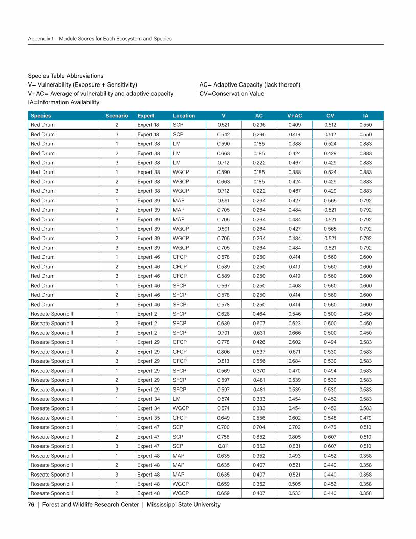
76 | Forest and Wildlife Research Center | Mississippi State University
Appendix 1 – Module Scores for Each Ecosystem and Species
Species Scenario Expert Location V AC V+AC CV IA
Red Drum 2 Expert 18 SCP 0.521 0.296 0.409 0.512 0.550
Red Drum 3 Expert 18 SCP 0.542 0.296 0.419 0.512 0.550
Red Drum 1 Expert 38 LM 0.590 0.185 0.388 0.524 0.883
Red Drum 2 Expert 38 LM 0.663 0.185 0.424 0.429 0.883
Red Drum 3 Expert 38 LM 0.712 0.222 0.467 0.429 0.883
Red Drum 1 Expert 38 WGCP 0.590 0.185 0.388 0.524 0.883
Red Drum 2 Expert 38 WGCP 0.663 0.185 0.424 0.429 0.883
Red Drum 3 Expert 38 WGCP 0.712 0.222 0.467 0.429 0.883
Red Drum 1 Expert 39 MAP 0.591 0.264 0.427 0.565 0.792
Red Drum 2 Expert 39 MAP 0.705 0.264 0.484 0.521 0.792
Red Drum 3 Expert 39 MAP 0.705 0.264 0.484 0.521 0.792
Red Drum 1 Expert 39 WGCP 0.591 0.264 0.427 0.565 0.792
Red Drum 2 Expert 39 WGCP 0.705 0.264 0.484 0.521 0.792
Red Drum 3 Expert 39 WGCP 0.705 0.264 0.484 0.521 0.792
Red Drum 1 Expert 46 CFCP 0.578 0.250 0.414 0.560 0.600
Red Drum 2 Expert 46 CFCP 0.589 0.250 0.419 0.560 0.600
Red Drum 3 Expert 46 CFCP 0.589 0.250 0.419 0.560 0.600
Red Drum 1 Expert 46 SFCP 0.567 0.250 0.408 0.560 0.600
Red Drum 2 Expert 46 SFCP 0.578 0.250 0.414 0.560 0.600
Red Drum 3 Expert 46 SFCP 0.578 0.250 0.414 0.560 0.600
Roseate Spoonbill 1 Expert 2 SFCP 0.628 0.464 0.546 0.500 0.450
Roseate Spoonbill 2 Expert 2 SFCP 0.639 0.607 0.623 0.500 0.450
Roseate Spoonbill 3 Expert 2 SFCP 0.701 0.631 0.666 0.500 0.450
Roseate Spoonbill 1 Expert 29 CFCP 0.778 0.426 0.602 0.494 0.583
Roseate Spoonbill 2 Expert 29 CFCP 0.806 0.537 0.671 0.530 0.583
Roseate Spoonbill 3 Expert 29 CFCP 0.813 0.556 0.684 0.530 0.583
Roseate Spoonbill 1 Expert 29 SFCP 0.569 0.370 0.470 0.494 0.583
Roseate Spoonbill 2 Expert 29 SFCP 0.597 0.481 0.539 0.530 0.583
Roseate Spoonbill 3 Expert 29 SFCP 0.597 0.481 0.539 0.530 0.583
Roseate Spoonbill 1 Expert 34 LM 0.574 0.333 0.454 0.452 0.583
Roseate Spoonbill 1 Expert 34 WGCP 0.574 0.333 0.454 0.452 0.583
Roseate Spoonbill 1 Expert 35 CFCP 0.649 0.556 0.602 0.548 0.479
Roseate Spoonbill 1 Expert 47 SCP 0.700 0.704 0.702 0.476 0.510
Roseate Spoonbill 2 Expert 47 SCP 0.758 0.852 0.805 0.607 0.510
Roseate Spoonbill 3 Expert 47 SCP 0.811 0.852 0.831 0.607 0.510
Roseate Spoonbill 1 Expert 48 MAP 0.635 0.352 0.493 0.452 0.358
Roseate Spoonbill 2 Expert 48 MAP 0.635 0.407 0.521 0.440 0.358
Roseate Spoonbill 3 Expert 48 MAP 0.635 0.407 0.521 0.440 0.358
Roseate Spoonbill 1 Expert 48 WGCP 0.659 0.352 0.505 0.452 0.358
Roseate Spoonbill 2 Expert 48 WGCP 0.659 0.407 0.533 0.440 0.358
Species Table AbbreviationsV= Vulnerability (Exposure + Sensitivity) AC= Adaptive Capacity (lack thereof)V+AC= Average of vulnerability and adaptive capacity CV=Conservation ValueIA=Information Availability

Gulf Coast Vulnerability Assessment: Mangrove, Tidal Emergent Marsh, Barrier Islands, and Oyster Reef | 77
Appendix 1 – Module Scores for Each Ecosystem and Species
Species Scenario Expert Location V AC V+AC CV IA
Roseate Spoonbill 3 Expert 48 WGCP 0.659 0.407 0.533 0.440 0.358
Spotted Trout 1 Expert 7 MAP 0.639 0.306 0.472 0.542 0.525
Spotted Trout 3 Expert 7 MAP 0.674 0.333 0.503 0.565 0.525
Spotted Trout 2 Expert 7 MAP 0.660 0.333 0.497 0.565 0.525
Spotted Trout 3 Expert 7 WGCP 0.674 0.333 0.503 0.565 0.525
Spotted Trout 1 Expert 7 WGCP 0.639 0.306 0.472 0.542 0.525
Spotted Trout 2 Expert 7 WGCP 0.660 0.333 0.497 0.565 0.525
Spotted Trout 1 Expert 18 SCP 0.535 0.315 0.425 0.512 0.550
Spotted Trout 2 Expert 18 SCP 0.535 0.315 0.425 0.512 0.550
Spotted Trout 3 Expert 18 SCP 0.556 0.315 0.435 0.512 0.550
Spotted Trout 1 Expert 19 LM 0.403 0.259 0.331 0.452 0.483
Spotted Trout 2 Expert 19 LM 0.403 0.222 0.313 0.405 0.483
Spotted Trout 3 Expert 19 LM 0.410 0.222 0.316 0.405 0.483
Spotted Trout 1 Expert 21 CFCP 0.476 0.389 0.433 0.464 0.717
Spotted Trout 2 Expert 21 CFCP 0.476 0.389 0.433 0.464 0.717
Spotted Trout 3 Expert 21 CFCP 0.472 0.389 0.431 0.464 0.717
Spotted Trout 1 Expert 21 SFCP 0.401 0.389 0.395 0.464 0.717
Spotted Trout 2 Expert 21 SFCP 0.409 0.389 0.399 0.464 0.717
Spotted Trout 3 Expert 21 SFCP 0.405 0.389 0.397 0.464 0.717
Wilson's Plover 1 Expert 23 CFCP 0.683 0.810 0.746 0.321 0.417
Wilson's Plover 2 Expert 23 CFCP 0.698 0.905 0.802 0.274 0.417
Wilson's Plover 3 Expert 23 CFCP 0.802 0.929 0.865 0.274 0.417
Wilson's Plover 1 Expert 23 SFCP 0.683 0.810 0.746 0.321 0.417
Wilson's Plover 1 Expert 26 SCP 0.819 0.542 0.681 0.429 0.367
Wilson's Plover 2 Expert 26 SCP 0.819 0.542 0.681 0.488 0.367
Wilson's Plover 1 Expert 33 LM 0.601 0.556 0.579 0.393 0.405
Wilson's Plover 2 Expert 33 LM 0.601 0.556 0.579 0.393 0.405
Wilson's Plover 3 Expert 33 LM 0.618 0.556 0.587 0.393 0.405
Wilson's Plover 1 Expert 34 LM 0.574 0.500 0.537 0.429 0.533
Wilson's Plover 1 Expert 34 WGCP 0.574 0.500 0.537 0.429 0.533
Wilson's Plover 1 Expert 42 MAP 0.674 0.438 0.556 0.393 0.583
Wilson's Plover 2 Expert 42 MAP 0.674 0.438 0.556 0.429 0.583
Wilson's Plover 3 Expert 42 MAP 0.694 0.438 0.566 0.429 0.583
Wilson's Plover 1 Expert 42 WGCP 0.736 0.417 0.576 0.393 0.583
Wilson's Plover 2 Expert 42 WGCP 0.736 0.417 0.576 0.429 0.583
Wilson's Plover 3 Expert 42 WGCP 0.743 0.438 0.59 0.429 0.583
Wilson's Plover 1 Expert 48 MAP 0.682 0.375 0.528 0.429 0.383
Wilson's Plover 2 Expert 48 MAP 0.682 0.375 0.528 0.429 0.383
Wilson's Plover 3 Expert 48 MAP 0.682 0.375 0.528 0.429 0.383
Wilson's Plover 1 Expert 48 WGCP 0.702 0.375 0.538 0.429 0.383
Wilson's Plover 2 Expert 48 WGCP 0.702 0.375 0.538 0.429 0.383
Wilson's Plover 3 Expert 48 WGCP 0.705 0.375 0.54 0.429 0.383
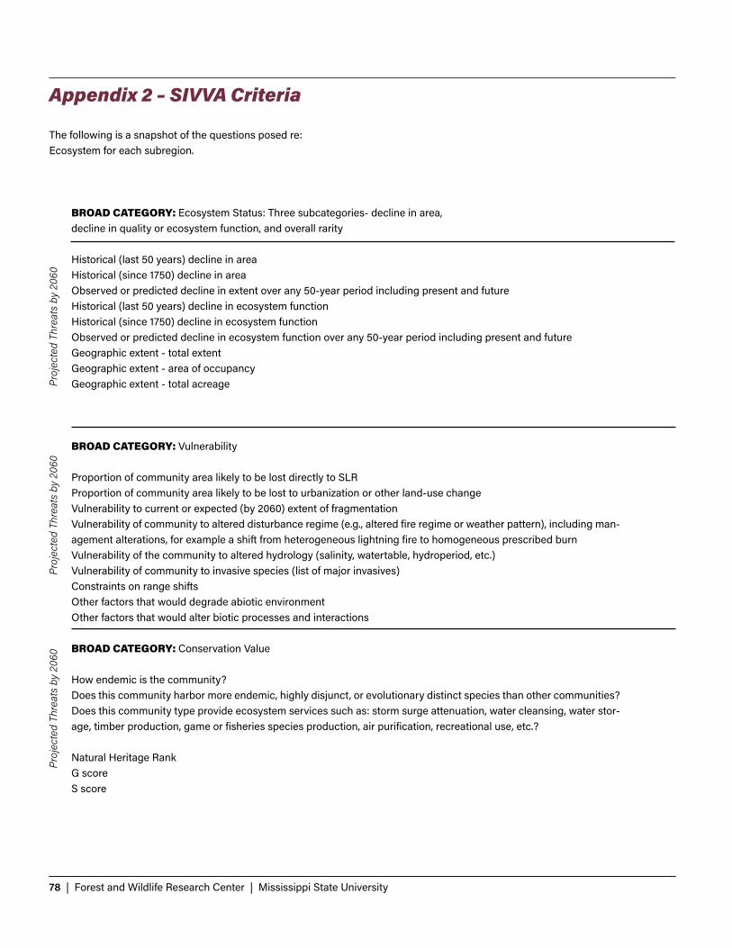
78 | Forest and Wildlife Research Center | Mississippi State University
BROAD CATEGORY: Ecosystem Status: Three subcategories- decline in area, decline in quality or ecosystem function, and overall rarity
Historical (last 50 years) decline in areaHistorical (since 1750) decline in areaObserved or predicted decline in extent over any 50-year period including present and futureHistorical (last 50 years) decline in ecosystem functionHistorical (since 1750) decline in ecosystem functionObserved or predicted decline in ecosystem function over any 50-year period including present and futureGeographic extent - total extentGeographic extent - area of occupancyGeographic extent - total acreage
BROAD CATEGORY: Vulnerability
Proportion of community area likely to be lost directly to SLRProportion of community area likely to be lost to urbanization or other land-use changeVulnerability to current or expected (by 2060) extent of fragmentationVulnerability of community to altered disturbance regime (e.g., altered fire regime or weather pattern), including man-agement alterations, for example a shift from heterogeneous lightning fire to homogeneous prescribed burnVulnerability of the community to altered hydrology (salinity, watertable, hydroperiod, etc.)Vulnerability of community to invasive species (list of major invasives)Constraints on range shiftsOther factors that would degrade abiotic environmentOther factors that would alter biotic processes and interactions
BROAD CATEGORY: Conservation Value
How endemic is the community?Does this community harbor more endemic, highly disjunct, or evolutionary distinct species than other communities?Does this community type provide ecosystem services such as: storm surge attenuation, water cleansing, water stor-age, timber production, game or fisheries species production, air purification, recreational use, etc.?
Natural Heritage Rank G scoreS score
Appendix 2 – SIVVA Criteria
The following is a snapshot of the questions posed re: Ecosystem for each subregion.
Proj
ecte
d Th
reat
s by
206
0Pr
ojec
ted
Thre
ats
by 2
060
Proj
ecte
d Th
reat
s by
206
0

Gulf Coast Vulnerability Assessment: Mangrove, Tidal Emergent Marsh, Barrier Islands, and Oyster Reef | 79
Appendix 2 – SIVVA Criteria
The following is a snapshot of the questions posed re: Species for each subregion.
BROAD CATEGORY: Vulnerability (Exposure + Sensitivity) Vulnerability (Exposure + Sensitivity) 1. Proportion of habitat inundated by or lost to SLR of .82m by 20602. Vulnerability to SLR through erosion in known range by substrate type/porosity inhabited3. Vulnerability of current distribution or 'escape paths' to current or future barriers4. Vulnerability due to dependence on a narrow temperature range5. Vulnerability due to dependence on a narrow range of seasonal precipitation6. Proportion of habitat already protected from development by a conservation area7. Vulnerability to increased fragmentation of populations due to SLR, climate, and land use8. Exposure and tolerance of increasing salinity due to SLR by 20609. Exposure and tolerance of storm surge or runoff from impervious surfaces by 206010. Exposure and/or sensitivity to competition/ displacement/ disease/biotic interactions relating to SLR, land use, and climate change11. Vulnerability to synergistic effects of projections for 2060 SLR, development, and climate change12. Vulnerability to changes in a natural disturbance regime as a result of climate, land use, or sea level changes by 2060
BROAD CATEGORY: Adaptive Capacity 1. Ability of species (not just individuals) to disperse away from 2060 threats - aka habitat tracking2. Phenotypic plasticity; including genetically controlled traits for which variation exists currently3. Genetic diversity4. Adaptive Rate (generation time, birth rate, fecundity)5. Demographic capacity to adapt in situ or to migrate6. Adaptive capacity of life history traits that affect survival and recruitment in colonized areas
BROAD CATEGORY: Conservation Value
7. Level of endemism8. Disjunct from other populations outside of Florida9. Keystone or foundation Species10. Phylogenetic distinctiveness11. Ecosystem service provider or economically important species12. Federal or state Listing13. Probability of recovery success
BROAD CATEGORY: Information Availability
14. Published and/or unpublished literature or expert knowledge available15. Existing demographic or niche models available16. Population genetic data available17. Demonstrated response to sea level rise18. Demonstrated response to climate change
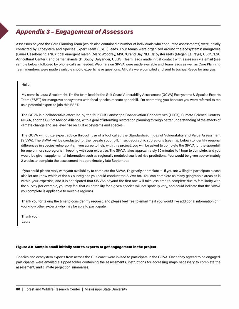
80 | Forest and Wildlife Research Center | Mississippi State University
Assessors beyond the Core Planning Team (which also contained a number of individuals who conducted assessments) were initially contacted by Ecosystem and Species Expert Team (ESET) leads. Four teams were organized around the ecosystems: mangroves (Laura Geselbracht, TNC); tidal emergent marsh (Mark Woodrey, MSU/Grand Bay NERR); oyster reefs (Megan La Peyre, USGS/LSU Agricultural Center); and barrier islands (P. Soupy Dalyander, USGS). Team leads made initial contact with assessors via email (see sample below), followed by phone calls as needed. Webinars on SIVVA were made available and Team leads as well as Core Planning Team members were made available should experts have questions. All data were compiled and sent to Joshua Reece for analysis.
Hello, My name is Laura Geselbracht, I'm the team lead for the Gulf Coast Vulnerability Assessment (GCVA) Ecosystems & Species Experts Team (ESET) for mangrove ecosystems with focal species roseate spoonbill. I'm contacting you because you were referred to me as a potential expert to join this ESET. The GCVA is a collaborative effort led by the four Gulf Landscape Conservation Cooperatives (LCCs), Climate Science Centers, NOAA, and the Gulf of Mexico Alliance, with a goal of informing restoration planning through better understanding of the effects of climate change and sea level rise on Gulf ecosystems and species. The GCVA will utilize expert advice through use of a tool called the Standardized Index of Vulnerability and Value Assessment (SIVVA). The SIVVA will be conducted for the roseate spoonbill, in six geographic subregions (see map below) to identify regional differences in species vulnerability. If you agree to help with this project, you will be asked to complete the SIVVA for the spoonbill for one or more subregions in keeping with your expertise. The SIVVA takes approximately 30 minutes to 1 hour to complete, and you would be given supplemental information such as regionally modeled sea level rise predictions. You would be given approximately 2 weeks to complete the assessment in approximately late September. If you could please reply with your availability to complete the SIVVA, I'd greatly appreciate it. If you are willing to participate please also let me know which of the six subregions you could conduct the SIVVA for. You can complete as many geographic areas as is within your expertise, and it is anticipated that SIVVAs beyond the first one will take less time to complete due to familiarity with the survey (for example, you may feel that vulnerability for a given species will not spatially vary, and could indicate that the SIVVA you complete is applicable to multiple regions). Thank you for taking the time to consider my request, and please feel free to email me if you would like additional information or if you know other experts who may be able to participate. Thank you,Laura
Figure A1: Sample email initially sent to experts to get engagement in the project
Species and ecosystem experts from across the Gulf coast were invited to participate in the GCVA. Once they agreed to be engaged, participants were emailed a zipped folder containing the assessments, instructions for accessing maps necessary to complete the assessment, and climate projection summaries.
Appendix 3 – Engagement of Assessors
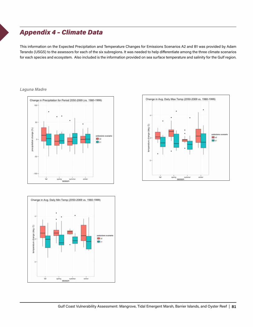
Gulf Coast Vulnerability Assessment: Mangrove, Tidal Emergent Marsh, Barrier Islands, and Oyster Reef | 81
This information on the Expected Precipitation and Temperature Changes for Emissions Scenarios A2 and B1 was provided by Adam Terando (USGS) to the assessors for each of the six subregions. It was needed to help differentiate among the three climate scenarios for each species and ecosystem. Also included is the information provided on sea surface temperature and salinity for the Gulf region.
Appendix 4 – Climate Data
Laguna Madre
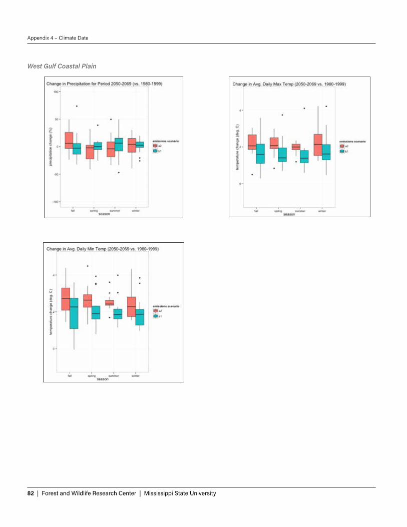
82 | Forest and Wildlife Research Center | Mississippi State University
Appendix 4 – Climate Date
West Gulf Coastal Plain

Gulf Coast Vulnerability Assessment: Mangrove, Tidal Emergent Marsh, Barrier Islands, and Oyster Reef | 83
Appendix 4 – Climate Date
Mississippi Alluvial Plain

84 | Forest and Wildlife Research Center | Mississippi State University
Appendix 4 – Climate Date
Southern Coastal Plain

Gulf Coast Vulnerability Assessment: Mangrove, Tidal Emergent Marsh, Barrier Islands, and Oyster Reef | 85
Appendix 4 – Climate Date
Central Florida Coastal Plain

86 | Forest and Wildlife Research Center | Mississippi State University
Appendix 4 – Climate Date
Southern Florida Coastal Plain

Gulf Coast Vulnerability Assessment: Mangrove, Tidal Emergent Marsh, Barrier Islands, and Oyster Reef | 87
Appendix 4 – Climate Date
Sea Surface Temperature Salinity

88 | Forest and Wildlife Research Center | Mississippi State University
These graphs show the variation across climate scenarios for each of the components of vulnerability. For species, those components are the two modules are Vulnerability and Adaptive Capacity, combined into Potential Impact. For ecosystems, the components are the Ecosystem Status and Vulnerability modules. Bars show the average module score for a species across climate scenarios.
Appendix 5 – Additional Climate Scenario Graphs

Gulf Coast Vulnerability Assessment: Mangrove, Tidal Emergent Marsh, Barrier Islands, and Oyster Reef | 89
Appendix 5 - Additional Climate Scenario Graphs

90 | Forest and Wildlife Research Center | Mississippi State University
Figures in this Appendix illustrate variation in expert opinion for the components of ecosystem and species vulnerability. Average species and ecosystem scores for the components of vulnerability are also displayed. For ecosystems, vulnerability was calculated by averaging the scores from Ecosystem Status module and Vulnerability module. For species, vulnerability (or Potential Impact) was calculated by averaging the scores from the Vulnerability and Adaptive Capacity modules. The dotted line is the average SIVVA score for all ecosystems and species. The orange lines are one standard deviation above and below, and the red lines are two standard deviations above and below the mean (which is equivalent to the 95% confidence interval for our purposes). Average vulnerability scores given by experts are averaged across subregions, climate scenarios, and species or habitats. Average ecosystem or species vulnerability are averaged across experts, subregions, and climate scenarios.
Appendix 6 – Additional Assessor Variation Graphs

Gulf Coast Vulnerability Assessment: Mangrove, Tidal Emergent Marsh, Barrier Islands, and Oyster Reef | 91
Appendix 6 – Additional Assesor Variation Graphs
Gulf Coast Vulnerability Assessment: Mangrove, Tidal Emergent Marsh, Barrier Islands, and Oyster Reef | 91

92 | Forest and Wildlife Research Center | Mississippi State University
Appendix 6 – Additional Assesor Variation Graphs

Gulf Coast Vulnerability Assessment: Mangrove, Tidal Emergent Marsh, Barrier Islands, and Oyster Reef | 93
Appendix 6 – Additional Assesor Variation Graphs

94 | Forest and Wildlife Research Center | Mississippi State University
Appendix 6 – Additional Assesor Variation Graphs

Gulf Coast Vulnerability Assessment: Mangrove, Tidal Emergent Marsh, Barrier Islands, and Oyster Reef | 95
Introduction
95 | Forest and Wildlife Research Center | Mississippi State University
In general, additional ecosystems throughout the Gulf include the following, which were not specifically included in this assessment but interact with or impact the ecosystems of focus:
• Banks and Shoals are geologic formations that rise from the seafloor to very near the water’s surface. The shape of a shoal or bank varies due to different processes. Banks are shaped by erosion during periods of low sea level while shoals are shaped by tidal and river currents. Banks typically occur on the continental shelf and have greater size and temporal persistence than shoals. These areas provide habitat to benthic invertebrates and support diverse macrofaunal assemblages (Normandeu Associates, Inc. 2014).
• Fresh and Non-fresh Submerged Aquatic Vegetation (SAV) beds are found throughout the coastal and estuarine ecosystems of the Gulf. SAV beds are dominated by rooted, vascular species such as seagrasses or rooted floating freshwater tidal vascular vegetation such as hornworts (Ceratophyllum spp.) or naiads (Najas spp.). Freshwater and brackish SAV have limited salt tolerance while seagrass beds occur in marine habitats and extend into the lower salinities of estuaries. Diverse faunal communities use these habitats for refuge and foraging.
• Macroalgae are types of aquatic vegetation beds that are attached to a substrate and exist within all depths of the photic zone. These communities can grow on a variety of substrates and across a range of energy and water chemistry regimes.
• Coral reefs are divided into two categories: deepwater/coldwater reefs and shallow/mesophotic coral reefs. Deepwater reefs are created by deepwater, stony corals or stylasterid corals. The living coral reef is characterized by the presence of live reef-forming corals, but other fauna may actually exceed the corals in percent cover. Shallow coral reefs occur in areas receiving great amounts of light that are dominated by reef-building hard corals or non-reef building reef colonizers. The growth form of the dominant coral reflects environmental conditions and provides habitat for fish and invertebrates. In the U.S. Gulf Coast, coral reefs are located near the Florida Keys and in the Flower Garden Banks National Marine Sanctuary on the Texas/ Louisiana shelf.
• Open Water is influenced by several factors including reduced air-water exchange, reduced light at depth, reduced wave impacts, and reduced interaction between the water column and sea floor. Open water habitat often serves as a heterotrophic zone supporting high rates of respiration which can lead to hypoxic or anoxic zones as the available oxygen is consumed. Salt wedge intrusion, due to stratification and mechanics of estuarine circulation, can cause bottom waters to be more saline than layers above.
• Subtidal and intertidal mud flats are defined as flat bottom habitats that lack an epifaunal oyster or seagrass community (Savarese 2013). To classify as subtidal or intertidal depends on the position of the flat relative to mean sea level and the sedimentary consistency of the substrate (<5% gravel). The flats provide foraging habitat for wading birds, grazing habitat for finfish, and support diverse invertebrate communities. These mud flats also provide coastal erosion, storm surge protection, and carbon sequestration (Savarese 2013).
Appendix 7 – Additional Ecosystems

96 | Forest and Wildlife Research Center | Mississippi State University
Appendix 7 - Additional Ecosystems
AR3, AR4, AR: The Third, Fourth, and Fifth Assessment Reports of the IPCC
BI: Barrier IslandsCBI: Conservation Biology Institute CDA: Coastal Drainage Areas CEC: Commission for Environmental Cooperation CFCP: Central Florida Coastal PlainCMECS: Coastal and Marine Ecological Classification
Standard CO2: Carbon dioxide CPRA: Coastal Protection and Restoration AuthorityEDA: Estuarine Drainage Areas ENSO: El Niño/Southern OscillationEPA: U.S. Environmental Protection Agency ESET: Ecosystem and Species Expert TeamGCP LCC: The Gulf Coast Prairie Landscape
Conservation CooperativeGCPO LCC: The Gulf Coastal Plains & Ozarks Landscape
Conservation Cooperative GCVA: Gulf Coast Vulnerability AssessmentGHG: Greenhouse GasGOMA: Gulf of Mexico AllianceHUC: Hydrologic Unit Code HWBI: Human Well-Being Index IPCC: Intergovernmental Panel on Climate Change IUCN: International Union for Conservation of NatureLC: Loop CurrentLCCs: Landscape Conservation CooperativesLM: Laguna MadreMAP: Mississippi Alluvial PlainNCED: National Conservation Easement DatabaseNEAFWA: Northeast Association of Fish and Wildlife
Agencies NGI: Northern Gulf Institute NOAA: National Oceanic and Atmospheric
Administration NWF: National Wildlife FederationPAD: Protected Areas Database PF LCC: Peninsular Florida Landscape Conservation
Cooperative
PPT: Parts per ThousandPSU: Practical Salinity Units RCPs: Representative Concentration PathwaysSA LCC: South Atlantic Landscape Conservation
Cooperative SAV: submerged aquatic vegetationSCP: Southern Coastal PlainSECAS: Southeast Conservation Adaptation StrategySE CSC: Southeast Climate Science Center SFCP: Southern Florida Coastal PlainSIVVA: Standardized Index of Vulnerability and Value
Assessment SLAMM: Sea Level Affecting Marshes ModelSLR: Sea-Level RiseSLEUTH: Slope, Land cover, Exclusion, Urbanization,
Transpiration, and Hillshade urban growth model
SOS: Surface Ocean SalinitySST: Sea Surface TemperatureTEM: Tidal Emergent MarshUSFWS: United States Fish & Wildlife ServiceUSGS: United States Geologic Survey WGCP: West Gulf Coastal Plain
Abbreviations and Acronyms

Gulf Coast Vulnerability Assessment: Mangrove, Tidal Emergent Marsh, Barrier Islands, and Oyster Reef | 97
Appendix 7 - Additional Ecosystems
Gulf of Mexico AllianceGulf Coast Prairie Landscape Conservation Cooperative (LCC)Gulf Coastal Plains and Ozarks LCCSouth Atlantic LCCPeninsular Florida LCCSoutheast Climate Science CenterSouth Central Climate Science Center
National Oceanic and Atmospheric Administration Northern Gulf Institute, Mississippi State University (MSU/NGI)Valdosta State UniversityU.S. Fish and Wildlife ServiceU.S. Geological Survey
List of Gulf of Mexico Partners
Julie Anderson Lively, LSU Agricultural Center & Louisiana Sea Grant
James Beerens, U.S. Geological SurveyJim Beever, Southwest Florida Regional Planning CouncilRon Bielefeld, Florida Fish and Wildlife Conservation
CommissionMike Brasher, Gulf Coast Joint VentureJanell Brush, Florida Fish and Wildlife Conservation
CommissionJust Cebrian, Dauphin Island Sea LabSimona Ceriani, Florida Fish and Wildlife Conservation
CommissionKevin Craig, NOAA Southeast Fisheries Science CenterJan Culbertson, Texas Parks and Wildlife DepartmentSoupy Dalyander, U.S. Geological SurveyZack Darnell, Nicholls State UniversityDiana Del Angel, Harte Research InstituteNancy Douglass, Florida Fish and Wildlife Conservation
CommissionCarolyn Enloe, Florida Fish and Wildlife Conservation
CommissionOwen Fitzsimmons, Coastal Bend Bays and Estuaries
ProgramMark Ford, National Park ServiceRyan Gandy, Florida Fish and Wildlife Conservation
CommissionSteve Geiger, Florida Fish and Wildlife Conservation
CommissionLaura Geselbracht, The Nature Conservancy Megan Goecker, Sustainable Ecosystem Restoration, LLCBeau Hardegree, U.S. Fish and Wildlife ServiceSusan Heath, Gulf Coast Bird Observatory
Read Hendon, University of Southern Mississippi Scott Holt, University of Texas Marine Science InstituteRandall Hughes, Northeastern University Marine Science
CenterErik Johnson, National Audubon Society/Audubon LouisianaChristopher Kelble, NOAA Atlantic Oceanographic and
Meteorological LaboratoryDavid Kidwell, NOAA National Centers for Coastal Ocean
ScienceLianne Koczur, Texas A&M University-KingsvilleMarianne Korosy, Audubon FloridaAlexander Kropp, Florida Fish and Wildlife Conservation
CommissionMegan La Peyre, U.S. Geological Survey/LSU Agricultural
CenterMargot Lamont, U.S. Geological SurveyAli Legett, Mississippi Department of Marine ResourcesJerry Lorenz, Audubon FloridaJeffery Marx, Louisiana Department of Wildlife and FisheriesAnne Mini, Lower Mississippi Valley Joint VentureMichael Murphy, The Nature ConservancyDavid Newstead, Coastal Bend Bays and Estuaries ProgramBrent Ortego, Texas Parks and Wildlife DepartmentMichael Osland, U.S. Geological Survey/GCPO LCCAnn Paul, Audubon FloridaAaron Pierce, Nicholls State UniversityNathanial Plant, U.S. Geological SurveyJennifer Pollack, Texas A&M University- Corpus ChristiMark Rachal, Audubon FloridaKara Radabaugh, Florida Fish and Wildlife Conservation
CommissionLance Robinson, Texas Parks and Wildlife Department
Ecosystem and Species Assessors (alphabetical)

98 | Forest and Wildlife Research Center | Mississippi State University
Appendix 7 - Additional Ecosystems
Kathryn Rose, NOAALawrence Rozas, NOAA Fisheries ServiceScott Rush, Mississippi State UniversityAmy Schwarzer, Florida Fish and Wildlife Conservation
CommissionMichael Seymour, Louisiana Department of Wildlife and
FisheriesTom Shearer, U.S. Fish and Wildlife Service
Katie Swanson, Mission-Aransas National Estuarine Research Reserve
John Tirpak, U.S. Fish and Wildlife ServiceGregory Tolley, Florida Gulf Coast UniversitySteve Traxler, U.S. Fish and Wildlife ServiceBill Vermillion, Gulf Coast Joint Venture
Ecosystem and Species Assessors (alphabetical) (continued)
Core Planning Team (alphabetical)
Bill Bartush, Gulf Coast Prairie LCCJorge Brenner, The Nature ConservancyDavid Brown, NOAACynthia Kallio Edwards, Gulf Coast Prairie LCCDavid Kidwell, NOAAKen McDermond, South Atlantic LCCRua Mordecai, South Atlantic LCCJim Pahl, Louisiana Coastal Protection AuthorityGeorge Ramseur, Mississippi Department of Marine
ResourcesJoshua Reece, Valdosta State UniversityBlair Tirpak, U.S. Geological Survey/Gulf Coast Prairie LCCJohn Tirpak, U.S. Fish and Wildlife ServiceAdam Terando, U.S. Geological Survey/Southeast Climate
Science CenterSteve Traxler, Peninsular Florida LCCGreg Wathen, Gulf Coastal Plains and Ozarks LCCAmanda Watson, Mississippi State University
Ecosystem and Species Expert Team Leads (alphabetical)
P. Soupy Dalyander, U.S. Geological Survey Laura Geselbracht, The Nature Conservancy Megan La Peyre, U.S. Geological Survey/LSU Agricultural
Center
Mark Woodrey, Mississippi State University/Grand Bay NERR
Editing and Review
Gregg Elliott, K. Gregg Consulting


Mississippi State University is an equal opportunity institution. Discrimination in university employment, programs or activities based on race, color, ethnicity, sex, pregnancy, religion, national origin, disability, age, sexual orientation, genetic information, status as a U.S. veteran, or any other status protected by applicable law is prohibited. Questions about equal opportunity programs or compliance should be directed to the Office of Compliance and Integrity, 56 Morgan Avenue, P.O. 6044, Mississippi State, MS 39762, (662) 325-5839.