gypsy, roma and traveller site assessment study
TRANSCRIPT

1
Elmbridge Local Plan Gypsy, Roma and Traveller Site Assessment Study
September 2018

2
Contents
1. Introduction and background ......................................................................... 4
2. Policy Framework .......................................................................................... 6
3. Existing Sites and Needs ............................................................................. 11
4. The need for a Transit Site .......................................................................... 15
5. Methodology ................................................................................................ 21
6. Results ......................................................................................................... 23
7. Conclusion ................................................................................................... 33

3
Disclaimer
In relation to the information contained within this report, its appendices and any other report relating to the findings of this assessment, the identification of potential sites, does not state or imply that the Council would necessarily grant planning permission for development. All planning applications will continue to be determined against the appropriate development plan and other relevant material considerations.
The conclusions in the assessment are based on information that was available at the time of the study and the Council does not accept liability for any factual inaccuracies or omissions. The information is a snapshot of the data captured for GRT sites submitted at a point in time. Information has been compiled with due care and attention, however inevitably discrepancies may occur.

4
Introduction and background
Purpose
1.1 The purpose of this study is to set out how to identify enough sites required to meet the accommodation needs of Gypsy, Roma and Travellers, in line with National Government Planning policy for traveller sites (PPTS) (2015). It sets out the methodology used to assess potential sites and then determine which (if any) of those either identified or submitted to the Council for potential designation, are suitable, available and achievable for development to meet the need identified as in the Council’s most recent Gypsy and Traveller Accommodation Assessment (GTAA) (February 2017).
1.2 The results of this study will inform the development of relevant policies and allocations in the emerging Local Plan which will guide the consideration of future planning applications for Gypsy, Roma and Traveller sites.
Background
1.3 For the purposes of planning policy, Gypsy, Roma and Travellers means:
‘Persons of nomadic habit of life whatever their race or origin, including such persons who on grounds only of their own or their family’s or dependents’ educational or health needs or old age have ceased to travel temporarily, but excluding members of an organised group of Travelling Showpeople or circus people travelling together as such.’ (Planning policy for traveller sites, CLG, August 2015).
1.4 Many Gypsy, Roma and Travellers continue to pursue an active itinerant
lifestyle and are generally self-employed people. However, increasingly communities are becoming more settled, for reasons such as providing children with an education; health reasons; and/or by them being older members of the Gypsy, Roma and Travelling community. This is critical to the new definitions when identifying the needs of this community.
1.5 Gypsy, Roma and Travellers are not a uniform homogeneous community, but
rather a group of communities which share some features but have their own histories and traditions. Even within each main group there is fragmentation between different families which emphasises the lack of a cohesive community and the need to avoid over generalisations. However, the main cultural groups include:
• Romany Gypsies;
• Irish Travellers; and
• New Travellers.

5
1.6 Romany Gypsies and Irish Travellers are recognised in law as distinct ethnic groups and are legally protected from discrimination under the Equality Act 2010.
1.7 In August 2015, Government published the Planning policy for traveller sites
and changed the definition of Gypsy, Roma and Travellers. The original 2012 version included Gypsy and Travellers who had ceased travelling permanently. The 2015 definitions now exclude those people who have ceased to travel permanently.
1.8 Local planning authorities are currently required to identify a supply of specific
sites to meet the needs of these groups within their local plans. This means that when delivering sites, consideration is required about which sites are available and suitable for different parts of the travelling community.

6
Policy Framework
Planning policy for traveller sites
2.1 National planning policy for traveller sites is contained within Planning policy for traveller sites, which was updated in 2015. There are two main changes to national policy, which relate to plan making: revised definitions (Annex 1) of Gypsies and Travellers; and a new paragraph (2 – Annex 1). These changes are set out below:
New planning definitions of Gypsies and Travellers
2.2 The revised 2015 national policy has changed the definition of Gypsies and Travellers. The original 2012 version included Gypsies and Travellers who had ceased travelling permanently. The revised 2015 definitions now exclude those people who have ceased to travel permanently.
2.3 A new paragraph (2) has been inserted into Annex 1 of the ‘Planning policy
for traveller sites’ for Gypsy and Traveller sites only, as set out below:
‘In determining whether persons are “gypsies and travellers” for the purposes of this planning policy, consideration should be given to the following issues amongst other relevant matters:
a) whether they previously led a nomadic habit of life b) the reasons for ceasing their nomadic habit of life c) whether there is an intention of living a nomadic habit of life in the future, and if so, how soon and in what circumstances.’ (Planning policy for traveller sites, CLG, August 2015)
2.4 There is no guidance provided by Government on the definition of living a
‘nomadic habit of life’ or the suitable ‘reasons for ceasing a nomadic habit of life’. It will be up to local authorities to establish which pitches / sites have people living a nomadic life and what reasons the occupiers of each pitch / site may have for ceasing to travel. This information should be collated during the needs assessment to establish the criteria set out above. This information needs to be collected for each household, i.e. for each pitch.
National planning policy - plan making for Gypsy and Traveller sites
2.5 Planning policy for travellers allows for ‘travelling’ Gypsy, Roma and Traveller households to be located within rural areas and the countryside, as well as in urban areas. However, in Elmbridge there is no land that is considered rural or countryside. It is either urban land or Green Belt land. The policy states that,

7
‘Green Belt boundaries should be altered only in exceptional circumstances. If a local planning authority wishes to make an exceptional, limited alteration to the defined Green Belt boundary (which might be to accommodate a site inset within the Green Belt) to meet a specific, identified need for a traveller site, it should do so only through the plan making process and not in response to a planning application. If land is removed from the Green Belt in this way, it should be specifically allocated in the development plan as a traveller site only.’ (Para 17, PPTS, August 2015).
2.6 Elmbridge Borough Council may need to consider whether there are the
exceptional circumstance to amend Green Belt boundaries due to the limited supply of urban areas suitable for Traveller sites.
2.7 National policy identifies three key criteria for identifying appropriate sites for
delivery through the planning system. To be deliverable within five years, or developable within years 6-15, sites should:
• Be suitable – the site should be in a suitable location for development;
• Be available - the site should be available now or there should be a reasonable prospect that the site is available at the point envisaged; and
• Be achievable – there is a realistic or reasonable prospect that a site could be viably developed at the point envisaged.
2.8 Local planning authorities should identify sufficient deliverable sites to provide five years’ worth of sites against their locally set targets. For years 6-10 and, where possible, for years 11-15, they should identify a supply of specific developable sites or broad locations for growth.
2.9 National policy recommends that criteria-based policies should be developed
irrespective of whether need is identified or not. If need is identified the policy should be used to guide the allocation of land, while if there is no identified need the policy should provide a basis for determining planning applications which may nevertheless come forward.
2.10 Planning policy for traveller sites identifies a series of issues for the criteria to
address to ensure that traveller sites are sustainable economically, socially and environmentally. Specific policies set out the national approach towards sites in rural areas and the countryside (Policy C), rural exception sites (Policy D), mixed planning use sites (Policy F), major development projects (Policy G) and determining planning applications (Policy H).
Planning policy - ‘Non-Traveling’ Gypsy, Roma and Traveller sites
2.11 The needs of Gypsy, Roma and Traveller households who do not meet the new ‘planning’ definition of a Traveller will need to be assessed separately

8
from ‘travelling’ Gypsy and Traveller households. In terms of spatial strategy, ‘Non-Traveling’ caravan sites should be located within the same locations as housing for the settled community, i.e. within the development boundaries of sustainable settlements identified within an adopted Local Plan.
2.12 Whilst households who do not travel fall outside the new planning definition of
a Gypsy and Traveller: Romany Gypsies and Irish and Scottish Travellers may be able to demonstrate a cultural need and right to a caravan site under the Equalities Act (2010). Also, the Housing and Planning Act (2016) now includes a duty for local authorities to consider the needs of people residing in or resorting to their district with respect to the provision of sites on which caravans can be stationed.
2.13 The identification of ‘Non-Traveller’ caravan pitches and/or sites should be
included within a housing land sub category, along with other specialist groups such as student accommodation and older people accommodation, of the Land Availability Assessment (LAA). The most significant issue here is whether the population and household projections and subsequently methodology adequately include this group within them and also how the delivery of caravans will then be counted.
Planning policy - ‘Unknown’ travelling status and needs
2.14 There is no guidance from Government on how unknown household needs should be planned for. These Gypsy, Roma and Traveller households do still need to be recognised as they are ethnic Gypsies and Travellers and may meet the new definition.
2.15 The GTAA has calculated a need for households with an ‘unknown’ travelling
status. All existing Gypsy Roma and Traveller pitches, with an ‘unknown’ travelling status, have been assessed for their potential for suitable, available and achievable ‘traveller’ pitches. This will inform any future planning applications that come forward on these sites and revisions of this study. For any decision to made on these sites, it will be reliant on the applicant to prove the residents meet the ‘traveller’ definition of the revised national ‘Planning policy for traveller sites’.

9
Local policy
2.16 This section sets out the existing Gypsy and Traveller policy in the Borough. This policy was adopted prior to the changes in national policy and the definition.
Core Strategy Policy CS22: Gypsies, Travellers and Travelling Showpeople
1. To meet the identified need for Gypsy, Traveller and Travelling Showpeople pitches within the Borough, as set out in the most up-to-date Gypsy and Traveller Accommodation Assessment, sufficient sites will be allocated within future DPDs that address site allocations. In allocating sites and for the purpose of considering planning applications relating to sites not identified in future DPDs that address site allocations, the following criteria will need to be satisfied:
• safe and convenient vehicular and pedestrian access to the site can be provided.
• there is easy and safe access to the strategic road network for Travelling Showpeople sites and the site does not generate traffic of an amount or type inappropriate for the roads in the area;
• the site is able to accommodate on site facilities for the parking and manoeuvring of vehicles (including exiting in forward gear) and storage, play and residential amenity space;
• the site is located within a reasonable distance by foot and/or public transport of local facilities and services, including schools and health facilities; and
• the site is environmentally acceptable and compatible with neighbouring land uses.
2. A sequential approach which prioritises the use of previously developed land in sustainable locations within urban areas will be taken to identifying sites for Gypsies, Travellers and Travelling Showpeople (also see CS2-Housing provision, location and distribution). The Council will consider the development of sites for Gypsies, Travellers and Travelling Showpeople in the Green Belt in accordance with PPG2.
3. Existing authorised Gypsy, Traveller and Travelling Showpeople sites will be
safeguarded, unless they are no longer required to meet identified need.
10
2.17 As part of the new Local Plan, the Council will take account of the needs of the Gypsy, Roma and Traveller Community in terms of identifying sufficient allocations to meet the identified need as set out in the latest GTAA (2017).
This will take the form of both allocations identified on the proposals map as well as a policy within the plan itself.
Other relevant guidance
2.18 Other relevant considerations which should be considered include:
• National policy set out within the National Planning Policy Framework (NPPF); and
• Communities and Local Government (CLG) Best Practice Guidance: Designing Gypsy and Traveller Sites (2008). This guidance was cancelled by Government in August 2015. However, this document was not planning policy and for guidance purposes only and therefore is still useful for guiding the design of Gypsy and Traveller sites.

11
Existing Sites and Needs
Introduction
3.1 PPTS states that the overarching aim of Government is “to ensure fair and equal treatment for travellers, in a way that facilities the traditional and nomadic way of life of travellers while respecting the interests of the settled community” (Para 3, PPTS, August 2015).
3.2 The policy document sets out the way in which the site needs of Gypsies, Travellers and Travelling Showpeople are planned for, including a system of locally generated targets. Under this, local planning authorities are required to:
• Use a robust evidence base to establish accommodation needs;
• Set pitch and plot targets to address the likely residential and transit site accommodation needs to Travellers in their area;
• Identify and update annually a supply of specific deliverable sites to provide five years’ worth of sites against locally set targets;
• Identify a supply of specific sites developable sites or broad locations for years six to ten and where possible for years 11-15; and
• Set criteria-based policies to meet identified need and/ or provide a basis for decisions in case applications nevertheless come forward.
3.3 The Council commissioned Opinion Research Services (ORS) to update the Elmbridge Borough Council Gypsy and Traveller Accommodation Assessment in 2017. The objective of the assessment being to quantify the number of Gypsy and Traveller pitches and Travelling Showpeople plots to meet identified needs to 2031. The study provides evidence to address the first two requirements of the PPTS set out above. The GTAA splits the travelling status of households (pitches) into 3 categories, as set out below:
• ‘Travelling’ Gypsy and Traveller households;
• ‘Unknown’ Gypsy and Traveller households; and
• ‘Non-travelling’ Gypsy and Traveller households.
3.4 This study identifies and assesses a pool of sites which have been identified by the Council for assessment. Each site will be assessed for ‘travelling’ Gypsy and Traveller development, as defined in the Government PPTS 2015. The objective is to provide evidence to identify and allocate sites in the emerging Local plan.
Existing Gypsy, Roma and Traveller Sites in Elmbridge
3.5 In Elmbridge there is a need for ‘travelling’ residential Gypsy and Traveller pitches. Residential sites provide residents with a permanent home, which

12
residents will travel from (and to) or for when they have ceased to travel due to education, health or may have older residents who can no longer travel. The sites can be privately owned, publicly rented for affordable pitches, or privately rented to other Gypsies and Travellers.
3.6 The amount of on-site facilities varies mainly between public and private sites.
Public sites will generally have amenity blocks and sometimes play areas and communal spaces. Private site facilities vary enormously depending on the specific and individual requirements of the residents.
3.7 The 2017 GTAA sought to understand the accommodation needs of the
Gypsy, Traveller and Travelling Showpeople population in Elmbridge through a combination of desk- based research, stakeholder interviews and engagement with members of the Travelling community. A total of 19 interviews were completed with Gypsies and Travellers living on authorised and unauthorised sites, and a further 1 interview was completed with a household living on a Traveller Showpeople yard.
Table 1: Existing Gypsy and Traveller sites within Elmbridge
Site Name Settlement Authorised Pitches/Plots
Unauthorised Pitches/Plots
Public Sites
The Oaks, Woodstock Lane South
Claygate 16 -
Private Sites with Permanent Permission
The Two Ways, Land Adjacent to the Oaks, Woodstock Lane South
Claygate 2 -
1, The Stables, Woodstock Lane South
Claygate 4 -
2, The Stables, Woodstock Lane South
Claygate 6 -
3, The Stables, Woodstock Lane South
Claygate 4 -
New Farm, Woodstock Lane South
Claygate 4 -
Willow Trees, 74 Hurtwood Road
Walton-on- Thames
1 -

13
Temporary Sites- Long-term without Planning Permission
The Paddocks, 41 Pleasant Place
Hersham 4 -
Unauthorised Sites†
The Paddock, Claygate Claygate - 2
Private Travelling Showpeople Yards
16 Sandy Lane Walton-on Thames
1 -
The unauthorised site was part of the GTAA assessment 2017 but has since left the site 2018.
Need for ‘travelling’ Gypsies and Traveller pitches
3.8 Based upon the evidence presented in the 2017 Gypsy and Traveller Accommodation Assessment, the estimated additional pitch provision needed to 2031 for Gypsies and Travellers in Elmbridge who meet the new definition of a Traveller is for 2 additional pitches. This is for a household currently doubling up on a site temporarily that needs a permanent pitch, together with household formation of 1 based on the demographics of the residents.
Table 2: Need for travelling Gypsies and Travellers
Years 0-5 6-10 11-15
2016-21 2021-26 2026-31 Total 1 0 1 2
Need for ‘unknown’ Gypsies and Travellers
3.9 Should further information be made available to the Council that will allow for the new definition to be applied to the ‘unknown’ households, the overall level of need could rise by up to 2 from unauthorised pitches1, by up to 3 from pitches with temporary planning permission, and by up to 4 from new household formation (this uses a base of the 16 households and a net growth rate of 1.50%. Therefore, additional need could increase by up to a further 9 pitches, plus any concealed adult households or 5-year need arising from older teenagers living in these households (if all 16 ‘unknown’ pitches are deemed to meet the new definition). However, as an illustration, if the national average of 10% were to be applied this could be as low as 1 additional pitch.
1 This unauthorised pitch no longer exists, and the Travellers have moved on. This number can now be discounted and has been removed from the 0-5 year total featured in the table for ‘unknown’ Gypsy and Traveller pitches in Elmbridge.

14
Table 3: Need for ‘unknown’ Traveller pitches in Elmbridge
Years 0-5 6-10 11-15
2016-21 2021-26 2026-31 Total 4 1 2 7
Need for ‘travelling’ showpeople plots
3.10 The TAA identified that there was no current need for any travelling showpeople plots that meet the new definition.
Needs for ‘Non travelling’ households.
3.11 The TAA has identified a need for non-travelling gypsy and travellers and non- travelling showpeople, however this study has not included the assessment of sites to meet the needs of either ’non-traveller’ gypsy and travellers and travelling showpeople. Instead this will be addressed as part of the wider housing needs of the area though the SHMA process and will form a subset of the wider need arising from households residing in caravans.
Need for Transit pitches
3.12 The need for a transit site in the Borough is discussed in the next chapter.

15
The need for a Transit Site
What is a transit site?
4.1 A transit site is an authorised site provided by a Local Authority on a permanent basis which provides basic facilities and services for short term stays. Gypsies and Travellers would have to sign agreements and pay for a pitch which may be for days or weeks, up to 12 weeks. Rental agreements would be enforced.
4.2 A transit site requires management including on-site supervision, daytime only entry and exit from site for caravans, chargeable pitch fees and conditions of hire agreements. Shared wash facilities and toilets would have to be provided. There would have to be a controlled barrier access to the site, with CCTV, secure boundaries and screening.
4.3 The requirements for transit sites reflect the fact that they are not intended for
use as a permanent base for an individual household.
4.4 Transit sites may present management challenges and depending on local circumstances and enough use, it is recommended that provision is generally made for a resident manager. As the resident manager will be living on the transit site on a semi-permanent basis, facilities for the manager should be provide including the provision of an amenity building.
4.5 The table below sets out the benefits of a Transit site but also the limitations
associated with providing this type of accommodation.
Benefits of a Transit Site Limitations
Reduce unauthorised encampments. Charge can result in families being unable or unwilling to pay for a transit pitch and still occupying an unauthorised encampment in the Borough.
Fees and rental agreements would pay for on site management and maintenance.
Need a significantly sized site to cater for large encampments otherwise overspill or larger unauthorised encampments will continue.
Police can move travellers out of the Borough if they refuse to go onto the transit site.
Can become a permanent site if short stay agreements are not enforced.
Land use is permanently changed.

16
Cost of infrastructure, security and management.
The Need for a Transit site
4.5 The GTAA 2017 evidence suggests that there is no need for a transit site in the Borough. It recommends a review of the evidence base relating to unauthorised encampments2 should be undertaken in Autumn 2018 once there is a new 3-year evidence base following the changes to PPTS in August 2015 including, attempts to try and identify whether households on encampments meet the new definition. This will establish whether there is a need for investment in more formal transit sites or emergency stopping places.
4.6 In the short-term, the GTAA suggests the Council should consider the use of short-term toleration or negotiated stopping agreements to deal with any encampments, as opposed to taking forward an infrastructure-based approach.
4.7 We now have 3 years of evidence (see table 4 below), but it has proved
difficult to assess whether the travellers meet the PTTS definition. It is likely they do as they are actively travelling and setting up camp in the Borough suggesting that they are travelling.
4.8 There is currently no methodology for working out whether a Local Planning
Authority has a specific need for a transit site. This is largely due to the lack of information provided by the families, when officers carry out welfare assessments. The only information that can be recorded easily is the caravan model, car make and registration numbers of vehicles.
4.9 An assessment of these caravan models and car details was undertaken in
2018 to see whether the same families were stopping or whether there was a pattern to the unauthorised encampments. Out of the 30 encampments only 6 contained similar vehicles and registrations numbers and not all of these were the same which adds doubt to whether the same family/ families were continually travelling through Elmbridge.
4.10 The lack of information makes it impossible to develop a methodology for
identifying need and assessing whether there is a genuine economic need for the travellers and whether a transit site is warranted.
4.11 For the last 3 years, unauthorised encampments on land in public ownership
has been recorded. Every year between April and October the Council has witnessed unauthorised encampments on a weekly basis. The table below
2 Unauthorised Encampments (Land that travellers do not own but set up camp temporarily)
17
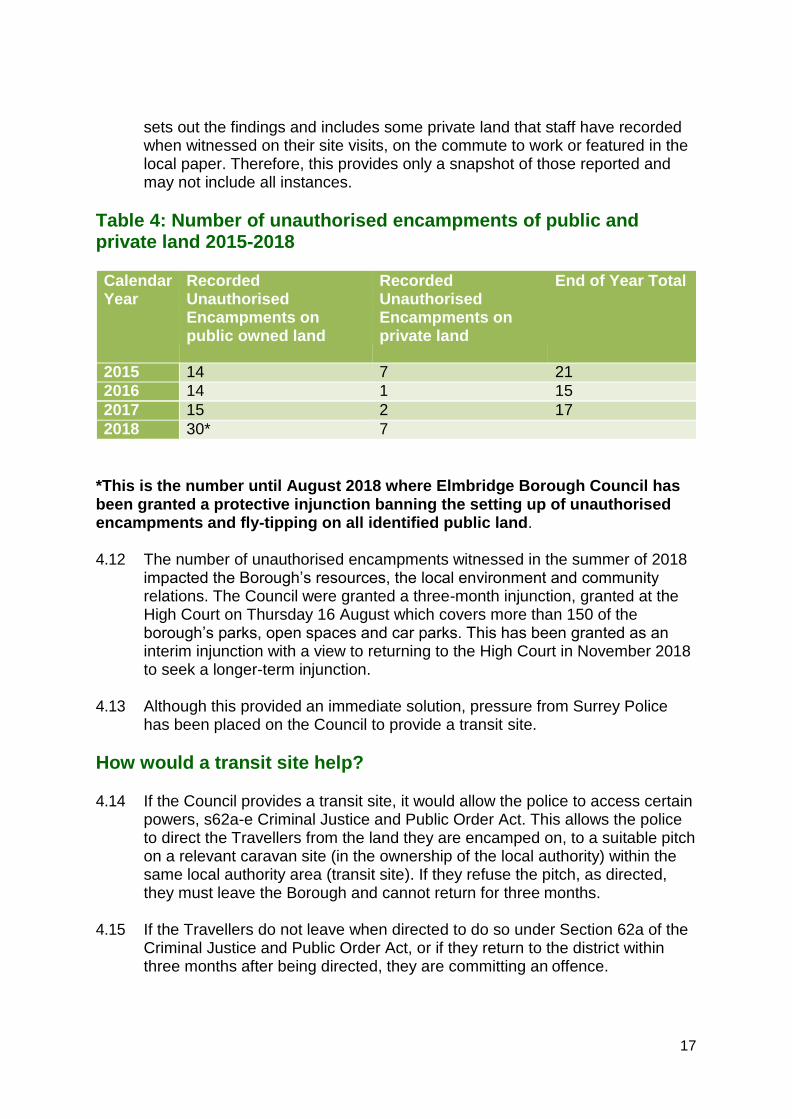
sets out the findings and includes some private land that staff have recorded when witnessed on their site visits, on the commute to work or featured in the local paper. Therefore, this provides only a snapshot of those reported and may not include all instances.
Table 4: Number of unauthorised encampments of public and private land 2015-2018
Calendar Year
Recorded Unauthorised Encampments on public owned land
Recorded Unauthorised Encampments on private land
End of Year Total
2015 14 7 21
2016 14 1 15
2017 15 2 17
2018 30* 7
*This is the number until August 2018 where Elmbridge Borough Council has been granted a protective injunction banning the setting up of unauthorised encampments and fly-tipping on all identified public land.
4.12 The number of unauthorised encampments witnessed in the summer of 2018
impacted the Borough’s resources, the local environment and community relations. The Council were granted a three-month injunction, granted at the High Court on Thursday 16 August which covers more than 150 of the borough’s parks, open spaces and car parks. This has been granted as an interim injunction with a view to returning to the High Court in November 2018 to seek a longer-term injunction.
4.13 Although this provided an immediate solution, pressure from Surrey Police
has been placed on the Council to provide a transit site.
How would a transit site help?
4.14 If the Council provides a transit site, it would allow the police to access certain powers, s62a-e Criminal Justice and Public Order Act. This allows the police to direct the Travellers from the land they are encamped on, to a suitable pitch on a relevant caravan site (in the ownership of the local authority) within the same local authority area (transit site). If they refuse the pitch, as directed, they must leave the Borough and cannot return for three months.
4.15 If the Travellers do not leave when directed to do so under Section 62a of the
Criminal Justice and Public Order Act, or if they return to the district within three months after being directed, they are committing an offence.

18
4.16 This evidence base document investigates any suitable and available land that could deliver a transit site.
Are there any alternatives?
4.17 There are a range of different transit site provisions that the Council can provide. These are outlined here:
• Emergency stopping places - more limited facilities.
• Temporary sites and stopping places - only temporary facilities to cater for an event.
• Negotiated stopping places - agreements which allow caravans to be sited on suitable specific pieces of ground for an agreed and limited period of time.
4.18 The 2017 GTAA suggests that the Council considers the use of short-term
toleration or negotiated stopping agreements to deal with any encampments, as opposed to taking forward an infrastructure-based approach in the form of a transit site.
4.19 Temporary stopping places accommodate intermittent needs for site
accommodation for which a charge may be levied as determined by the local authority concerned. They are not occupied all year around but may be available at times of increased demand. The benefits of this approach is that the land use can return to its original land use and no permanent infrastructure needs to be installed.
4.20 Temporary stopping places should provide safe and convenient access to
road networks and be located to cause minimum disruption to surrounding communities.
4.21 When considering the suitability of different sites, the potential presence of
young children and any risks that may arise due to adjoining uses must be considered.
4.22 It is important to provide markings or barriers to encourage residents to park
safely, allow access for emergency vehicles, and enable maximum use of the site in accordance with its intended capacity and fire safety standards. Regard must be given to the need to ensure a safe distance between trailers/caravans and other structures made of combustible materials. The advice of the Local Fire Officer must be sought during the planning of temporary stopping places.
4.23 The road to and from the site must be of sufficient quality and size to enable
access onto and off the site by heavy vehicles such as trailers.
4.24 There must be a clear barrier around the emergency stopping place to discourage unauthorised expansion of the site.
19
4.25 It is essential for a cold-water supply to be provided for the use of site residents which may be by use of water standpipe or bowser. Port-a-loos must be provided for the use of residents, with separate provision for men and women. There must be at least one port-a-loo for every four households on the site. It is essential for a sewerage disposal point to be provided. Refuse disposal facilities should also be provided.
4.26 This document provides information about which sites could be suitable and
available for use as a temporary stopping place if this is deemed as an appropriate method for managing unauthorised encampments in the Borough.

20
Methodology
Introduction
5.1 This section sets out the methodology, which has been developed in line with the National Government’s Planning policy for traveller sites (PPTS) 2015.
Sources of sites
5.2 The sources of sites to consider are listed below:
• All existing Gypsy and Traveller and Travelling Showpeople sites- including the consideration of intensification and expansion of existing sites, as well as assessing temporary, tolerated and unauthorised pitches to become permanent;
• Sites put forward for Gypsy and Traveller and/or Travelling Showpeople development through the call for sites; and
• Elmbridge Borough Council and Surrey County Council owned land in the urban area and the Green Belt.
• Any other sites suggested.
Site Assessment
5.3 National policy identifies three key criteria for identifying appropriate sites for delivery through the planning system. To be deliverable within five years, or developable within years 6-15, sites should:
• Be suitable – the site should be in a suitable location for development;
• Be available - the site should be available now or there should be a reasonable prospect that the site is available at the point envisaged; and
• Be achievable – there is a realistic or reasonable prospect that housing could be viably developed at the point envisaged.
5.4 Stage 1 of the site assessment involved a desktop study using the Council’s Geographical Information System (GIS) to identify the broad suitability of the site by considering National and Local designations and potential impacts.
5.5 Stage 2 provides a more detailed assessment of suitability, availability and
achievability to determine whether the site is deliverable.
21
Stage 1 Assessment
5.6 All site addresses from the 4 sources of sites are listed in a database. Site details are recorded with the name/address of the site and site area in hectares. Each site is given a site reference.
5.7 At this stage in the assessment, the existing traveller sites will only be
assessed to whether there is any additional land on the site to expand, intensify or make permanent a temporary permission. Using an area of 325sqm for a double pitch, each site was assessed to see whether a pitch or pitches could be accommodated on the existing site. Only if they did have space to accommodate pitches would the next set of suitability questions be relevant.
Suitability: Environmental (National and Local Designations)
5.8 The following questions are asked:
Flooding- Is the site located in Flood Risk Zone 2 or 3? The PTTS states that Local Authorities do not locate sites in areas at high risk of flooding including functional floodplains, given the vulnerability of caravans.
National Designation- Is the site located in a Special Protection Area, Ramsar site, Site of Special Scientific Interest, SANG site, registered Town and Village Greens, Ancient Woodland or Park or Garden of Special Historic Interest.
Local Designation- Is the site located in the Green Belt land, Biodiversity Opportunity Area, Local Nature Reserve, Site of Nature Conservation Importance.
Historic Environment- Is the site located in an Area of High Archaeological Potential, a Conservation Area, or near a Listed Buildings, Scheduled Ancient Monument.
Suitability: Potential Impacts
Land Use- Is it in employment use? It is using for recreational purposes?
Contaminated land- Does the site contain areas of unstable or contaminated land that is likely to undermine the site’s suitability and achievability.
Topography- Is it on a slope?
Site Access and Safety- is there safe site access and access to the main road network? Can an 11m long caravan enter and leave the site easily?

22
Accessibility to services- Is the site 400 to 800km (walking distance) to local shops, bus services, primary and secondary school and GP service?
Noise- Is the site located adjacent to noisy land uses and will there be limited noise impact from the site?
Residential Amenity- Relates to the impact of adjoining uses on potential Traveller site.
Neighbouring Amenity- Relates to the impact of the potential Traveller site on adjoining uses.
Water Quality – There is no risk to the supply and quality of water resources.
Landscape- Impact of site upon landscape and visual containment of site.
Stage 2 Assessment
5.9 Those sites considered suitable from the Stage 1 assessment are then considered in more detail in an individual site proforma. This allows for key information to be recorded, a site description, an account of planning history and designations and an aerial and location map. The proforma looks at suitability in more detail including the sustainability of the site and then includes important questions on the availability and the deliverability. An example of the proforma can be viewed at Appendix 2.
Whether or not the site is considered deliverable or developable
5.10 To be considered deliverable, sites should be available now, offer a suitable location for development, and be achievable with a realistic prospect that development will be delivered on the site within five years. Sites with planning permission should be considered deliverable until permission expires, unless there is clear evidence that schemes will not be implemented within 5 years, for example they will not be viable, there is no longer a demand for the type of units or sites have long term phasing plans.
5.11 To be considered developable, sites should be in a suitable location for
traveller site development and there should be a reasonable prospect that the site is available and could be viably developed at the point envisaged.

23
Assessment Results
6.1 45 sites were identified for assessment in total. These include:
1. 10 Existing Traveller and Travelling showpeople sites 2. 0 Sites from the call for sites exercise 3. 9 Public sites in the urban area 4. 23 Public sites located in the Green Belt 5. 3 Other privately owned site located in the Green belt.
1. Existing Traveller and Travelling Showpeople Sites
6.2 As explained in the methodology, it is important to assess existing Gypsy, Roma and Traveller sites to see whether there are opportunities for expansion or extension to accommodate further pitches.
6.3 As set out in Section 2 of this document, the 2017 GTAA identified 10 existing
sites in the Borough including 1 public Gypsy and Traveller site at the Oaks and 1 unauthorised site. As explained in the methodology section, these sites have only been subject to a stage 1 assessment. The table below summarises the outcome of this assessment.
Table 5: Summary of the Borough’s existing Traveller and Travelling Showpeople sites expansion assessment results.
Site Ref
Site Address Ha Discount Reason for discounting
E1 The Oaks, Woodstock Lane South (Public site)
0.71 Yes No land available to accommodate a 325sqm double pitch.
E2 The Two Ways, Land Adjacent to the Oaks, Woodstock Lane South
0.52 Yes No land available to accommodate a 325sqm double pitch.
E3- 5
1-3 The Stables, Woodstock Lane South
0.44 Yes No land available to accommodate a 325sqm double pitch.
E6 New Farm, Woodstock Lane South
0.23 Yes No land available to accommodate a 325sqm double pitch.
E7 Willow Trees, 74 Hurtwood Road
0.03 Yes No land available to accommodate a 325sqm

24
double pitch.
E8 The Paddocks, 41 Pleasant Place
0.51 (0.61*)
No This temporary permission could be made permanent and expanded by 3 pitches.
E9 The Paddock, Claygate 0.1 Yes Unauthorised site no longer exists.
E10 16 Sandy Lane, Walton- on-Thames
0.12 No Planning application (2017/1743) for residential property. Loss of Travelling Show people site considered acceptable in report.
*Expanded site size
6.4 Due to the lack of space at these sites none of these sites would be suitable for a transit or temporary stopping place.
6.5 1 existing site which currently has temporary permission could be made
permanent which would create 4 permanent private pitches. It could also be expanded to the east and to the north which would provide an additional 3 pitches.
6.6 The GTAA 2017 reported that currently the site occupiers 3 unknown
travellers and 1 traveller that meets the definition. The permanency of the site would meet 3 of the 4 unknown pitch needs in the first 5 years of the plan and 1 household that meets the definition. The additional 3 pitches could meet the existing need for the 1 travelling traveller and the unknown travellers.
6.7 Therefore, a further 7 permanent pitches could be provided from existing sites
in the Borough.
RESULT- 7 private permanent pitches from existing Gypsy, Roma and Traveller sites in the Borough.
2. Sites from the call for sites exercise
6.8 Gypsy, Roma and Traveller representatives registered on our database were contacted. We asked the groups to publicise the call for sites across the Traveller community. The consultation lasted for 4 weeks and the letter is located at appendix 1. Unfortunately, we received no responses from the Traveller community and hence cannot assess any sites put forward from this

25
source.
RESULT- 0 private/public pitches from the call for sites
3. Council owned sites in the urban area
6.9 There are 9 sites that are owned by Elmbridge Borough Council that have been assessed for Gypsy, Roma and Traveller accommodation use. These are generally small sites that are located within the urban area. Each of these sites have been through the stage 1 and stage 2 assessment. Individual proformas for each site are available to view at appendix 3.
6.10 The assessment does not include any Surrey County Council owned sites in the urban area. This is because none of these are considered suitable for assessment as they are either too small or many of them are in active community use such as schools, school fields and library / youth centres.
Table 6: Summary of the Council owned sites in the urban area assessment results.
Sit e Ref
Site Address
Ha Suitability for permanent site
Suitabilit y for Transit site
Discount Reason for discounting
U1 River Mole Business Park, Mill Road, Esher
1.8 4
Sustainable location. No environment al or absolute constraints. Could accommodat e up to 15 pitches.
Poor access to strategic road network.
No- site is considere d suitable available and deliverabl e for permanen t pitches.
-
U2 Halfway Car Park, Walton- on- Thames
0.2 2
Sustainable location. No environment al or absolute constraints. Could accommodat e up to 4 pitches.
Too small Yes Small site size. Overlooking/priva cy issues. Lack of space for landscaping scheme. Public car park in high use. High land value

26
U3 Walton Park Car Park, Walton- on- Thames
0.6 3
Sustainable location. No environment al or absolute constraints. Could accommodat e up to 12 pitches.
Poor access to strategic road network.
Yes Overlooking/priva cy issues. Commuter car park in moderate use. High land value
U4 Torringto n Lodge Car Park, Claygate
0.1 6
Sustainable location. Car park in low use. No environment al or absolute constraints. Could accommodat e up to 3 pitches.
Too small Yes Small site size. Overlooking/priva cy issues. High land value.
U5 New Berry Lane Car Park, Hersham
0.1 5
Sustainable location. No environment al or absolute constraints. Could accommodat e up to 3 pitches.
Too small Yes Small site size. Some compatibility issues with adjoining supermarket / delivery times and disturbance. Public car park in high use. High Land value
U6 Hare Lane Car Park, Claygate
0.1
6 Sustainable location. Car park in low use. No environment al or absolute constraints. Could accommodat e up to 3
Too small Yes Use at rear of site requires access and parking facilities. Small site. Access close to roundabout. Residential properties adjoining site could have privacy/

27
pitches overlooking issues.
U7 Berguette Car Park, Claremon t Lane, Esher
0.1 5
Sustainable location. Could accommodat e up to 3 pitches.
Too small Yes Topography- located on slope Site size (small) and shape (long & narrow). Public car park in high use. High Land value
U8 Southban k Car Park, Long Ditton
0.2 2
Sustainable location. Site partially in flood risk zone 2. Could accommodat e 3 pitches on area not in FZ2.
Too small Yes Public car park in moderate use. High Land value. Limited space for landscaping.
U9 Mayfield 0.4 Sustainable Poor Yes Proximity to Road Car 6 location. access to railway line (& Park No strategic noise environment road transference) al or High land value absolute Triangular shape constraints. may limit usage Could Commuter car accommodat park in e 8 pitches. moderate/good
use.
6.11 The 8 discounted sites are not only unsuitable for permanent Gypsy, Roma and Traveller site but are also unsuitable for a transit site or temporary stopping place. The is largely due to the size of the urban sites making it impossible to supply the elements required for a transit site and their access to road networks in terms of a stopping place.
6.12 The only site considered suitable for the provision of a permanent Gypsy,
Roma and Traveller site was the River Mole Business Park, which could accommodate up to 15 pitches in total. The Council’s Asset Management and Property Services have confirmed its availability and that Traveller accommodation could be provided within the wider development plan for the whole site. They have confirmed that this could be delivered in a 6-10-year

28
time scale.
6.13 This site is not considered suitable for a Transit site or temporary stopping site as it is not on a strategic road network.
RESULT- Up to 15 permanent Gypsy, Roma and Traveller pitches have been identified and could be provided on Council owned sites in the urban area.
4. Council owned sites located in the Green Belt
6.14 22 Elmbridge Borough Council and 1 Surrey County Council owned sites
located in the Green Belt have been identified for assessing their suitability for either a permanent site or a transit site. They have been subject to a stage 1 assessment but detailed proformas have not been provided for these sites due to their broad locations in the Green Belt.
6.15 The table below presents the findings of the stage 1 assessment.
Table 7: Council owned sites located in the Green Belt assessment results
Site Ref
Site Address Ha Discount Reason for discounting
G1 Randalls Farm, Portsmouth Road, Cobham
3.73 Yes Surrounded by a village green, is heavily wooded and an area of natural greenspace. Narrow access onto A307.
G2 Lower Green Recreation Ground, Farm Road, Esher
2.222 Yes Flood Risk Zone 2, Recreation Ground.
G3 Land lying to the east of and known as Hersham Riverside
1.805 Yes Flood Risk Zone 2, limited access
IMPORTANT:
The above results/ findings provide enough sites to meet the Borough’s needs for ‘travelling’ and ‘unknown’ travellers in the GTAA 2017. It goes beyond the need and hence this site could be safeguarded for any future need beyond the plan period. However, none of these urban sites allow for the provision of a transit site and hence the following source of sites must be considered.

Park, Profumo Road, Hersham, Walton-on- Thames
G4 Land on the south east side of Portsmouth Road, Fairmile Common, Cobham
2.89 Yes Partial registered town and village Green, heavily wooded.
G5 Land lying to the north east of Thrupps Lane, Hersham
3.64 Yes Flood Risk Zone 2, access onto smaller residential roads
G6 Recreation Ground next to River Mole Business Park, Mill Road, Esher
2.11 Yes Flood Risk Zone 2, Recreation Ground
G7 Land on the north and south side of Lower Green Road, Esher
0.9 Yes Flood Risk Zone 2, potential overlooking and privacy issues, proximity of rail line.
G8 Land lying to the east of Pleasant Place, Hersham
1.33 Yes Some of this land could be used to expand the existing temporary Traveller site, which could be made permanent. This has been factored in at point 1 of the results.
The greater expansion of the land to the south could present issues in terms of scale of site.
The existing temporary Gypsy, Roma and Traveller site would prevent the provision of a Transit Site as well as its location which is some distance from the strategic road network.
G9 Land lying to the east of Pleasant Place, Hersham
G10 Land lying to the east of Pleasant Place, Hersham
G11 Land lying to the east of Pleasant Place, Hersham
G12
Land on the east side of Pleasant Place, Hersham
G13 Land and buildings on the north side of Oaken Lane, Thames Ditton
3.09 Yes Restricted access and the relocation of a rugby club/pitch.
29

30
G14 Emberside Recreation Ground, Grove Way, Esher
1.38 Yes Recreation Ground and located on a residential road
G15 Land lying to the south of Heathside, Thames Ditton
7.7 Yes Flood Risk Zone 2 and Registered Village Green
G16 10 Ridgeway, Walton- on-Thames
0.03 Yes Flood Risk Zone 2, difficult access, overlooking and privacy issues
G17 Mount Felix and Redwood, The Ridgeway
0.04 Yes Flood Risk Zone 2, difficult access, overlooking and privacy issues
G18 Land on the south east side of Terrace Road, Walton -on- Thames
2.04 Yes Heavily wooded, Biodiversity Opportunity Area, Natural Greenspace.
G19 Land on the south side of Terrace Road, Walton on Thames
G20 Apps Court Green, Hurst Road, Walton- on-Thames
1.13 No Investigate further for a Transit Site/ temporary stopping place.
G21 Land and buildings on the north side of Walton Lane, Weybridge
1.11 Yes Flood Risk Zone 2 and 3, Weybridge Tennis and Sailing Club
G22 Land on the north side of Walton Lane, Weybridge
0.66 Yes Flood Risk Zone 2 and 3, Elmbridge Canoe Club, potential overlooking issues
G23 Land to the north east of 143 Terrace Road
12.2 Yes Flood Risk Zone 2 on south west side. Biodiversity Opportunity Area. Gravel Pit. Historic landfill site. Thames Policy Area.
RESULT- 1 Council owned site in the Green Belt requires a stage 2 assessment for a Transit site / temporary stopping place.

31
5. Other sites suggested
6.16 The following sites have been suggested by officers for the provision of a transit site:
1. Land to the north of the Cobham Motorway Service Area, M25 Junction 10 to
Junction 9, Wisley, Surrey, KT11 3DB 2. New Barn Farm, Bookham Road, Downside, Cobham, KT11 3JS 3. Bull Riding Farm, Horsley Road, Cobham, KT11 3LA
These sites have been assessed at stage 1 and 2 and have detailed proformas at Appendix 4.
6.17 The issue with sites 2 and 3 is that occupiers of the transit site would need to
cross the service station to be able to access the M25 via the slip road. The owners of the M25 service station have confirmed that the site is not available for development. The owners of Bull Riding Farm have also confirmed that they are not interested in developing or selling their land for development.
RESULT- No other sites suggested are available for a transit site.

32
Conclusion
7.1 Out of the 45 sites have been assessed the following sites have been highlighted as having the potential to meet the Borough’s needs for the 2 ‘travelling’ travellers and the 7 ‘unknown’ travellers set out in the GTAA 2017.
These results are summarised in the table below:
Site Address Source What need
will the site address
Private/ or Public
Deliverability
The Paddocks, 41 Pleasant Place, Hersham
Existing Temporary Permission
The need for 5 ‘unknown’ traveller pitches and 2 ‘travelling’ traveller pitches
7 private pitches
1-5 years
River Mole Business Park, Mill Road, Esher
Council owned site in the urban area
The need for 2 ‘unknown’ travellers
2 private pitches
Potential for up to 13 public pitches for future need
6-10 years
Land to the south of The Paddocks, 41 Pleasant Place, Hersham
Council owned site in the Green Belt
Future need Public or private
11-15 years
Apps Court Green, Hurst Road, Walton-on- Thames
Council owned site in the Green Belt
Future transit or stopping site
Transit / temporary stopping site
11-15 years
7.2 The table shows that 4 pitches with temporary permission at Pleasant Place, Hersham could be made permanent and the site expanded to accommodate a further 3 pitches. With 7 pitches provided in total, this would allow the 2

33
‘travelling’ traveller need to be met and 5 ‘unknown’ traveller pitches to be met. This could be achieved in a 1-5-year period as 4 pitches already exist and planning permission for the temporary use expires in July 2019. As the site is in private use, the site would accommodate 7 private pitches.
7.3 Up to 15 permanent traveller pitches could be located at the River Mole
Business Park. This would provide pitches for the remaining 2 ‘unknown’ traveller pitches. This could be achievable in a 6-10-year period. Although, there is a need for 1-2 public pitches for ‘unknown’ travellers, it may not be viable to create a public site for such a small number. However, there is enough land at the Business Park for 15 pitches in total and so there is scope to accommodate a larger public site at this location. This could be safeguarded for future need.
7.4 Broad locations within the Green Belt in public ownership have been
considered in this assessment and will be investigated further should the need for Gypsy, Roma and Traveller accommodation increase in the years beyond the plan period. Currently, one of the broad locations is considered suitable and available for a Transit site or temporary stopping place in the Borough. However, these will need to be investigated further to determine their developability and need.
7.5 This site assessment helps to identify deliverable and developable sites to
meet the Borough’s Gypsy, Roma and Traveller accommodation needs. It provides the information needed for the Council to make the decision on how and where we plan to meet this need.

34
Appendix 1: Letter to the Gypsy, Roma and Traveller Representatives.

Appendix 2: Urban Site Proformas

Site Name: River Mole Business Park, Mill Road, Esher, KT10 8BJ Site Reference: U1
Key Information
Settlement: Esher
Ward: Esher Site Area: 1.84 ha
Current Land Use: Offices (Use Class B1a), Storage Buildings and associated Yard (Use Class B8) and Car Parking.
How the site was identified: Elmbridge Borough Council – Asset Management & Property Services
Landowner: Public (Elmbridge Borough Council).
Figure 1: Aerial View
• The majority of the site is within the Planning Consultation
area for a Government Oil Pipeline which is east of the site.
Site Description: The site consists of 6 units used for office and storage space with associated outside yards/storage areas and car parking. Owned by the Borough Council, it provides accommodation for a small number of businesses as well as being the location for the Council’s depot. The site is located within an area that hosts a variety of uses including commercial premises, residential properties, recreational facilities, and key infrastructure. To the south and west of the site is Sandown Industrial Park, providing 14 units including Units A & B which are also being promoted for residential development. Just beyond the industrial park, to the west of the site is the River Mole. To the east of the site and to the south, towards the access road, are a number of residential properties including the Joseph Locke Way area and Harvest Court development. A railway line also runs south of the site. To the east of the site is also the Lower Green Recreation Ground. The northern part of the site (0.26ha), open countryside and Water Pollution Control Centre beyond, are located within the Green Belt. Access to the site is via Mill Road.
Planning History & Designations
Planning History: No relevant planning history. Designations:
• ESH06 – Lower Green Environs.
• The entirety of the site is identified as potentially contaminated land due to the industrial and commercial uses associated with the site. There is also unknown filled grounds, an old river channel and gravel pit located adjacent to the site.
Designations within 20m of site boundary

• Flood Zone 2 of the River Mole runs along the northern boundary of the site and the adjacent Units A & B Sandown Industrial Park. Flood Zone 2 infringes on the very northern extent of the site.
• Ground Water Vulnerability Zone – Major HU covers the entire site.
• Ground Water Vulnerability Zone 10km Buffer.
• A footpath runs along the northern boundary of the site providing access across the River Mole.
• The site adjoins the Green Belt to the north.
• Lower Green Recreation Ground & Skate Park is located east of the site.
• The site is within the buffer area of the historic landfill site at Land South of Field Common Lane.
• Adjacent to the northern boundary of the site is the Field Common Site of Nature Conservation Importance (SNCI) and Biodiversity Opportunity Area.
Photo 1: Industrial Units at River Mole Business Park, Esher
Photo 2: Entrance to River Mole Business Park, Esher
Photo 3: The Council’s Depot, River Mole Business Park

Photo 1
Photo 2
Photo 3
Figure 2: Location Plan

The Assessment
Assessment Criteria Additional questions Assessment Comments
Suitability
Is it a suitable location for development now?
Is the site large enough to accommodate pitches?
Could accommodate up to 15 pitches based on a double pitch size of 325m² in a smaller section of the site.
Does any of the site fall within Flood zone 2 or 3?
No
Any other environmental designation?
Esher SANG 5km buffer
Does it impact on heritage or archaeology?
Adjoins an area of High Archaeological Potential
Will the land use need re- provision?
The businesses/ existing uses may need relocation at another Industrial Park in the Borough.
Is there safe and convenient vehicular and pedestrian access to the site?
There is direct vehicular access onto Mill Road. Currently, the industrial environment does not lend itself to safe pedestrian access onto Mill Road but changing the use of the whole site would allow enough walkways and safe pedestrian routes to be incorporated into the design. Access for Traveller vehicles could be accommodated to the east of the site.
Is there easy access to public transport?
The nearest bus stops are available on Farm Road, 395 metres away from the site. These offer a less frequent bus route (1 per hour) between Weybridge and Addlestone through Brooklands (515- Kingston to Addlestone). Esher rail station is located 1.78km away.
Is there easy access to shops and services?
No- the site is not within 800m of a local, district or town centre. The limited bus route allows hourly access to Brooklands and Kingston, the regional shopping centre.
Is there good access to Hospitals, NHS GPs and dentists?
The closest GP surgery (Esher Green) is located 0.91km from the site, which is an 11-minute walk. The closest dentist is located on Portsmouth Road 1.88km away, which is a 24-minute walk. Kingston Hospital is accessible via the hourly bus service.

Is there easy access to a primary school and secondary school?
Cranmere Primary School is located 0.84km from the site, a 10-minute walk away. The nearest secondary school is Esher Church of England High School. This is located 1.03km from the site, which is an 11-minute walk away.
Is the site flat? Yes
Can the site provide visual and acoustic privacy?
Yes- the site size allows for the designing of adequate visual and acoustic privacy.
Is there access to mains water, electricity supply, drainage and sanitation?
Yes- existing infrastructure
Is the site environmentally acceptable? (not on contaminated land/near pylons/flyovers etc)
Historic Landfill Sites 250m buffer Paper packaging products manufacturer 1919-1938 Previous paper mill/linoleum factory/bookbinders. Factory and works 1960s and 1990s
Is it compatible with neighbouring land uses?
The site is being promoted for housing development and depending on the design of this, traveller pitches could be incorporated in the scheme. The size of the site could allow for a sensitivity designed traveller accommodation.
Availability
Is the site available for release? The site is contained within the Surplus/Vacant property section of the Asset Management Plan. However, it is still in use by contractors of Environmental Services.
Are there any legal or ownership problems such as unresolved multiple ownerships, random strips, tenancies or operational requirements of landowners that would prevent the site being developed?
The site is subject to tenancies and management agreements.
If there is an issue as described above- can this be overcome?
With compulsory powers all interests or missing parts can be overcome though this will cost in terms of compensation and advisory fees.
Achievability/Viability
Please provide a judgement about the economic viability of the site.
Can the site be released/sold/rented and developed for the provision of a traveller site within a five-year time frame?
Yes (subject to reversion of leases). Site has relatively low existing use value (EUV) and would suggest that Alternative Use Value (AUV) is constrained by site location and nearby land uses.
What are the financial implications of this?
Can the development be funded/ afforded? What funding streams/grants can be sought?
Assuming that pitches are provided as affordable housing, then funding streams that could be sought include:
• HCA grant – Affordable Homes Programme (2015- 18)

• EBC Capital Programme
• EBC Enabling Fund Would need a discussion with HCA as to likely contribution.
Will the release of this site for traveller accommodation be supported and prioritised by the Council?
Any ideas for seeking support and ensuring that this delivery is a Council priority?
This site might receive more support than others, because its relatively low site value means that potential to realise a sizeable capital receipt through disposal is limited.
Fringe location might be advantageous, although nearby land uses may impact on quality of life of residents.
Also, if potential mixed-use (residential and traveller site) scheme is being proposed then offers possibility of packaging sites / consents together and putting onus on developer to deliver both elements (in return for purchasing the site).
Deliverability
What is the time scale for delivery of the site?
Developable within 5 years
Developable in 6-10 years √ Work is needed with regards to the investigation of potential contaminated land and the access to the east side of the site for traveller accommodation. Additionally, the current uses will need relocating.
Developable in 11-15 years
Developable beyond 15 years
Not deliverable/ developable
*Average Occupancy – 10:00 to 14:00 – Mon-Fri only
Based on maximum occupancy across the 3x April, May, June 2017 sample weeks, at a given time. These maximum figures for each minute of the 10:00-14:00 period, then averaged to give an average occupancy for a car park.
The Result
The site is suitable, available and deliverable/ developable.

Site Name: Land on the north east side of Hersham Road, (Halfway Public Car Park) Walton on Thames Site Reference: U2
Key Information
Site Description: The site consists of a public car park located on the east side of Hersham Road. It is accessed via a slip road and located at the rear of the Halfway local centre. There is a large car showroom (Peugeot) to the south of the site. To the north of the site lies a church building, electrical sub-station as well as a row of terraced shops with flats above fronting Hersham Road. The centre contains a range of retail, commercial and mixed-use properties. Residential properties back the north east of the site at Danesfield Close. There is minimal boundary screening to the site, but the floor level is flat and there is safe and easy access for pedestrians and vehicles to access the site. A range of local services are accessible in the Halfway centre and there is a bus stop directly outside the site that offered two services; one that runs to Shepperton/Laleham/Staines and the other that provides transport to Walton Station and Hersham. Walton on Thames rail station is located some 500m away and is accessible via an 8-minute walk.
ard: Walton South
Site Area: 0.22 ha
Current Land Use: Car Park (Sui Generis)
How the site was identified: Elmbridge Borough Council – Asset Management & Property Services
andowner: Public (Elmbridge Borough Council).
Planning History & Designations
Planning History: No relevant planning history. Designations:
• WAL07– The Halfway
• TBH SPA 7m buffer.
• Contaminated land- garage, car sales, factory/works- adjoins part of site boundary to south.
• Halfway local centre
• Strategic view
• Major HU
Figure 3: Ariel View

• Ground Water Vulnerability Zone 10km Buffer.
Designations within 20m of site boundary
• A Road
• U Road- Fernleigh Close
• WAL06- Rydens

Figure 4: Location Plan -
The Assessment
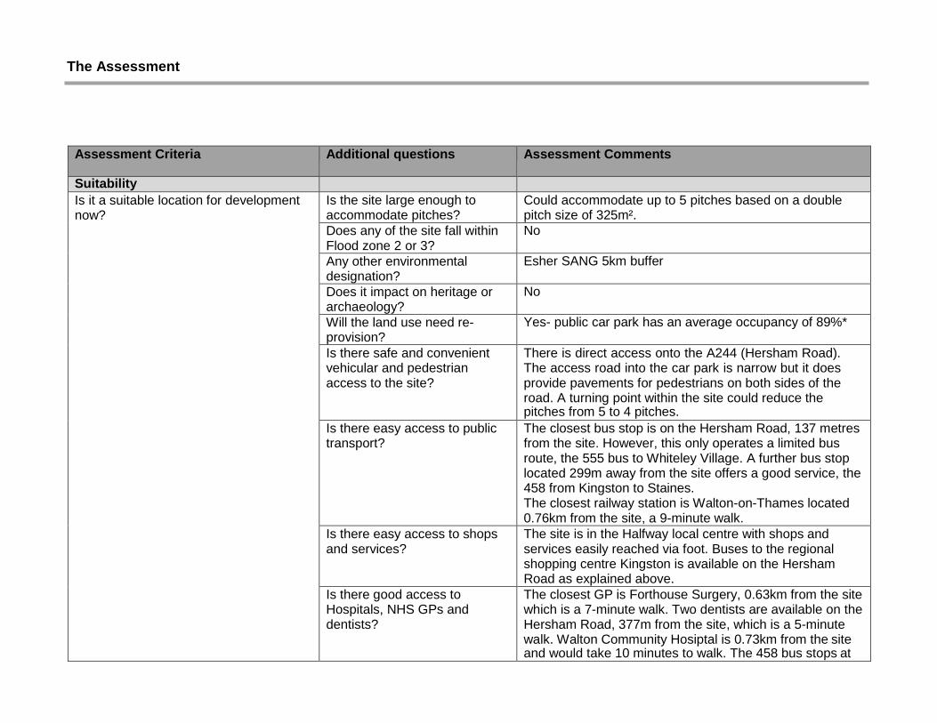
Assessment Criteria Additional questions Assessment Comments
Suitability
Is it a suitable location for development now?
Is the site large enough to accommodate pitches?
Could accommodate up to 5 pitches based on a double pitch size of 325m².
Does any of the site fall within Flood zone 2 or 3?
No
Any other environmental designation?
Esher SANG 5km buffer
Does it impact on heritage or archaeology?
No
Will the land use need re- provision?
Yes- public car park has an average occupancy of 89%*
Is there safe and convenient vehicular and pedestrian access to the site?
There is direct access onto the A244 (Hersham Road). The access road into the car park is narrow but it does provide pavements for pedestrians on both sides of the road. A turning point within the site could reduce the pitches from 5 to 4 pitches.
Is there easy access to public transport?
The closest bus stop is on the Hersham Road, 137 metres from the site. However, this only operates a limited bus route, the 555 bus to Whiteley Village. A further bus stop located 299m away from the site offers a good service, the 458 from Kingston to Staines. The closest railway station is Walton-on-Thames located 0.76km from the site, a 9-minute walk.
Is there easy access to shops and services?
The site is in the Halfway local centre with shops and services easily reached via foot. Buses to the regional shopping centre Kingston is available on the Hersham Road as explained above.
Is there good access to Hospitals, NHS GPs and dentists?
The closest GP is Forthouse Surgery, 0.63km from the site which is a 7-minute walk. Two dentists are available on the Hersham Road, 377m from the site, which is a 5-minute walk. Walton Community Hosiptal is 0.73km from the site and would take 10 minutes to walk. The 458 bus stops at

Kingston which would allow a connecting bus to Kingston Hospital.
Is there easy access to a primary school and secondary school?
Bell Farm Primary School is located 0.65km from the site, which is a 10 minute away. Rydens Enterprise School is the closest secondary school. This is located 0.65km away, which is a 6-minute walk away.
Is the site flat? Yes
Can the site provide visual and acoustic privacy?
Due to the site size is maybe difficult to provide visual and acoustic privacy.
Is there access to mains water, electricity supply, drainage and sanitation?
Yes- existing infrastructure
Is the site environmentally acceptable? (not on contaminated land/near pylons/flyovers etc)
The public car park itself is not contaminated but the adjoining land is for car sales and repairs. Used mainly for the storage of cars, the area to the rear of the showroom is used for vehicle repair and respraying.
Is it compatible with neighbouring land uses?
Located in built up area with flats and shops to the north and smaller residential dwellings to the east. The built-up nature and noise/ disturbance from the car showroom may present a compatibility issue.
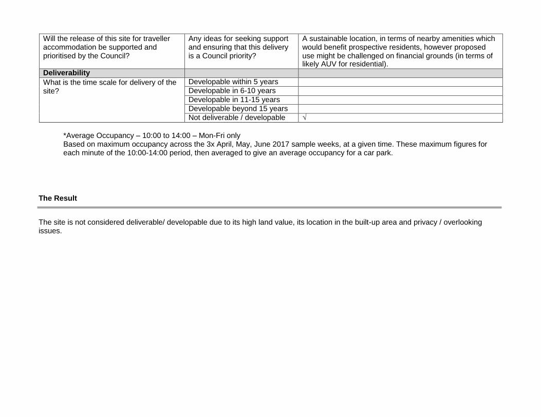
Availability
Is the site available for release? The Corporate Asset Management Plan 2014-2017 states that the Halfway public car park is underutilized and is a potential development site. However, since that publication, the car park is in greater use.
Are there any legal or ownership problems such as unresolved multiple ownerships, random strips, tenancies or operational requirements of landowners that would prevent the site being developed?
Unknown
If there is an issue as described above- can this be overcome?
Unknown
Achievability/Viability
Please provide a judgement about the economic viability of the site.
Can the site be released/sold/rented and developed for the provision of a traveller site?
Site has low EUV, but potentially higher EUV than some others (e.g. River Mole Business Park)

What are the financial implications of this?
Can the development be funded/ afforded? What funding streams/grants can be sought?
Assuming that pitches are provided as affordable housing, then funding streams that could be sought include:
• HCA grant – Affordable Homes Programme (2015- 18)
• EBC Enabling Fund
• EBC Capital Programme
Would need a discussion with HCA as to likely contribution.
Will the release of this site for traveller accommodation be supported and prioritised by the Council?
Any ideas for seeking support and ensuring that this delivery is a Council priority?
It is a sustainable location, in terms of nearby amenities, which would be a benefit for prospective residents. However, the site is small and there are some compatibility issues with neighbouring land uses.
Deliverability
What is the time scale for delivery of the site?
Developable within 5 years
Developable in 6-10 years
Developable in 11-15 years
Developable beyond 15 years
Not deliverable/developable √
*Average Occupancy – 10:00 to 14:00 – Mon-Fri only Based on maximum occupancy across the 3x April, May, June 2017 sample weeks, at a given time. These maximum figures for each minute of the 10:00-14:00 period, then averaged to give an average occupancy for a car park.
The Result
The site is not considered deliverable/ developable due to its high occupancy as a public car park, high land value, size and its location in the built-up area.

Site Name: Walton Park Car Park, Walton on Thames Site Reference: U3
Key Information
Settlement: Walton on Thames
Ward: Walton South Site Area: 0.63 ha Current Land Use: Car Park (Sui Generis) How the site was identified: Elmbridge Borough Council – Asset Management & Property Services Landowner: Public (Elmbridge Borough Council).
Figure 5: Ariel View
• Planning Consultation C Roads- Molesey Road
Site Description: The site consists of a public car park with residential roads to the north, east south and west of the site. It is a large car park providing 147 parking spaces and 3 disabled parking bays. The car park provides all day parking for commuters to Hersham Station which is located some 100m to the south east of the site. It also provides short stay parking for visitors to the nearby business park at the east of the site. The site is flat and quite exposed with little boundary screening surrounding the site. It provides safe and easy access for pedestrians and vehicles. It is also easily accessible to the strategic road network. The site is not particularly close to shopping centre but there are local schools nearby. The train station is within walking distance and a bus stop is located on the Molesey Road. Bus routes allow access across to the north of the Borough incorporating Hersham and Walton as well as the Excel leisure centre and the larger shopping centres of Surbiton and Kingston.
Planning History & Designations
Planning History: No relevant planning history.
Designations:
• Planning Consultation U Roads, Lindley Road, Saxon Road, Walton Park, Denton Grove and Walton Park Lane
• Design and Character Area WAL06- Rydens
• Ground Water Vulnerability MAJOR HU
• Strategic View
Designations within 20m of site boundary

• Rights of Way- Footpath
• Design and Character Area WAL12- Hersham Industrial Estate
• Contaminated land 07-2013 Industrial/Commercial Units and Factory or works.
• Strategic Employment Land- Lyon Road/ North Weylands, Walton on Thames
• Walton Ambleside Ward

Figure 6: Location Plan – Walton Park Car Park

The Assessment
Assessment Criteria Additional questions Assessment Comments
Suitability
Is it a suitable location for development now?
Is the site large enough to accommodate pitches?
Could accommodate up to 10 pitches based on a double pitch size of 325m². This commuter car park has an average occupancy of 50%*. Therefore, the site could still provide commuter car parking and 4-5 pitches.
Does any of the site fall within Flood zone 2 or 3?
No
Any other environmental designation?
SANG 5km buffer
Does it impact on heritage or archaeology?
No
Will the land use need re- provision?
This commuter car park has an average occupancy of 50%*. Therefore, the site could still provide commuter car parking and 4-5 pitches.
Is there safe and convenient vehicular and pedestrian access to the site?
There is direct access to Walton Park and then Molesey Road.
Is there easy access to public transport?
Bus stops are 141m from the site on the Molesey Road. There is a limited bus service from Kingston to Weybridge including Esher High School (514) and Hersham to Walton Leisure Centre (564)
Is there easy access to shops and services?
The nearest local centre is at Halfway which is located 1.46km away from the site (4-minute walk). Buses to the regional shopping centre Kingston is available on the Molesey Road.
Is there good access to Hospitals, NHS GPs and dentists?
Rodney Road GP Surgery is located 1.43km from the site. The nearest dental surgery is located on the Walton Road, 489m away. The Walton Community hospital is located 1.43km away
Is there easy access to a primary school and secondary school?
The closest primary school is Cardinal Newman RC Primary School, which is in walking distance at 0.60km. Rydens Enterprise school is the closest secondary school which is located 1.71km away.

Is the site flat? Yes
Can the site provide visual and acoustic privacy?
The provision of screening is possible but the noise from remaining car park users may impact on privacy.
Is there access to mains water, electricity supply, drainage and sanitation?
Yes- existing infrastructure in built up area.
Is the site environmentally acceptable? (not on contaminated land/near pylons/flyovers etc)
Yes
Is it compatible with neighbouring land uses?
Residential properties are located to the north, east and west of the site. Compatibility will depend on the visual and acoustic privacy.
Availability
Is the site available for release? The Corporate Asset Management Plan 2014-2017 states that the Walton Park public car park is underutilized and is a potential development site.
Are there any legal or ownership problems such as unresolved multiple ownerships, random strips, tenancies or operational requirements of landowners that would prevent the site being developed?
Unknown
If there is an issue as described above- can this be overcome?
Unknown
Achievability/Viability
Please provide a judgement about the economic viability of the site.
Can the site be released/sold/rented and developed for the provision of a traveller site within a five-year time frame?
Site has low EUV, but probably a higher potential AUV for housing.
What are the financial implications of this?
Can the development be funded/ afforded? What funding streams/grants can be sought?
Assuming that pitches are provided as affordable housing, then funding streams that could be sought include: • HCA grant – Affordable Homes Programme (2015- 18) • EBC Enabling Fund • EBC Capital Programme Would need a discussion with HCA as to likely contribution.
Will the release of this site for traveller accommodation be supported and prioritised by the Council?
Any ideas for seeking support and ensuring that this delivery is a Council priority?
A sustainable location, in terms of nearby amenities which would benefit prospective residents, however proposed use might be challenged on financial grounds (in terms of likely AUV for residential).
Deliverability
What is the time scale for delivery of the site?
Developable within 5 years
Developable in 6-10 years
Developable in 11-15 years
Developable beyond 15 years
Not deliverable / developable √
*Average Occupancy – 10:00 to 14:00 – Mon-Fri only Based on maximum occupancy across the 3x April, May, June 2017 sample weeks, at a given time. These maximum figures for each minute of the 10:00-14:00 period, then averaged to give an average occupancy for a car park.
The Result
The site is not considered deliverable/ developable due to its high land value, its location in the built-up area and privacy / overlooking issues.

Site Name: Torrington Lodge Car Park, Claygate Site Reference: U4
Key Information
Settlement: Claygate Ward: Claygate Site Area: 0.29 ha Current Land Use: Car Park (Sui Generis) How the site was identified: Elmbridge Borough Council – Asset Management & Property Services
Landowner: Public (Elmbridge Borough Council).
Figure 7: Ariel View - Hare Lane Car Park, Claygate
Site Description: The site consists of a public car park which is accessible via a slip road off Hare Lane. It sits behind a row of shops fronting Hare Lane. A row of detached properties lie to the north facing Torrington Close. Detached residential properties are located at the north, east and south of the site with rear gardens abutting the boundaries of the car park. There are a number of trees that surround the site allowing some boundary screening. The site is located in close proximity to shops and services. The site would allow for safe access for both pedestrians and vehicles and would allow easy and safe to access the strategic road network.
Planning History & Designations
Planning History: No relevant planning history. Designations:
• CLAY02 – Historic Centre Environs.
• Strategic View.
• Ground Water Vulnerability Zone 10km Buffer.
Designations within 20m of site boundary
• CLAY06 – Hare Lane, Oaken Lane & Telegraph Lane Environs.
• Claygate Village Conservation runs along the site’s eastern boundary.

• Hare Lane & High Street are Planning Consultation ‘C’ Roads.
• Oaken Lane is a Planning Consultation ‘U’ Road.

Figure 8: Location Plan – Torrington Lodge Car Park, Claygate

The Assessment
Assessment Criteria Additional questions Assessment Comments
Suitability
Is it a suitable location for development now?
Is the site large enough to accommodate pitches?
Could accommodate up to 8 pitches based on a double pitch size of 325m². The car park is underutilized and operates at 41%* The site could still contain public parking and the pitches could be reduced to 4.
Does any of the site fall within Flood zone 2 or 3?
No
Any other environmental designation?
SANG 5km buffer
Does it impact on heritage or archaeology?
No
Will the land use need re- provision?
The car park is underutilized and operates at 41%* The site could still contain public parking and the pitches could be reduced to 4.
Is there safe and convenient
vehicular and pedestrian access to the site?
There is safe and convenient vehicular and pedestrian access to the site.
Is there easy access to public transport?
The K3 bus stop is located opposite the site and offers a ‘good’ bus service to Esher and Kingston (82m).
Is there easy access to shops and services?
The site is in the Claygate Village local centre and therefore local shops and services are accessible via foot.
Is there good access to Hospitals, NHS GPs and dentists?
Elm GP Surgery is located 0.72km away from the site. This is accessible via the K3 bus. A dentist is located 80m away on the Hare Lane. Kingston hospital is accessible via the K3 bus.
Is there easy access to a primary school and secondary school?
Claygate primary School is located 0.71km away from the site.
Is the site flat? Yes
Can the site provide visual and acoustic privacy?
Yes- landscaping could be provided to provide visual an acoustic privacy.
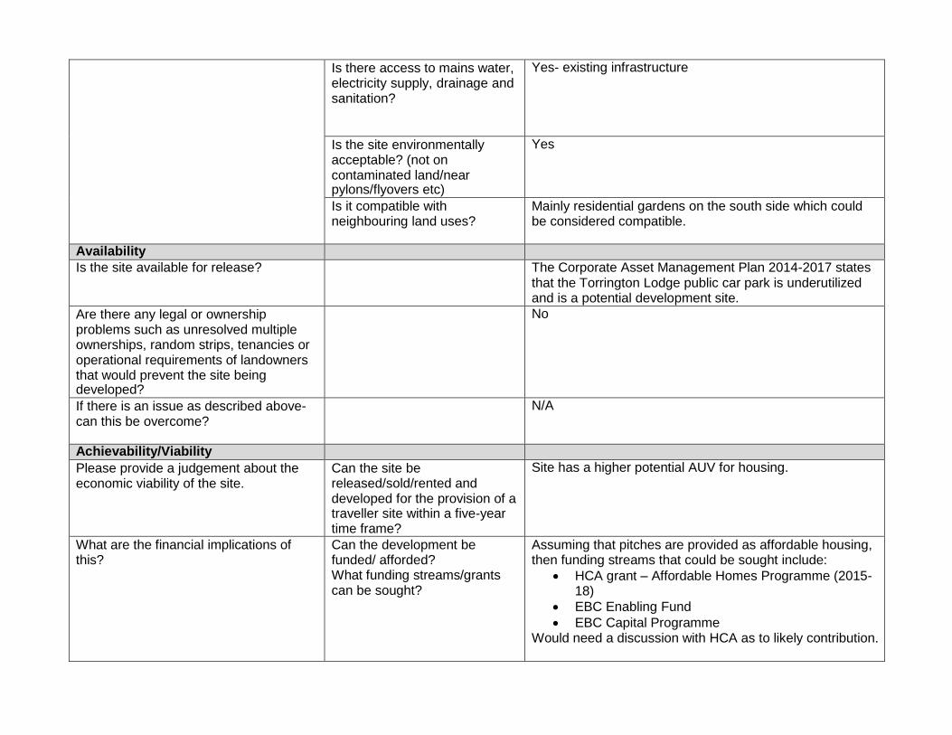
Is there access to mains water, electricity supply, drainage and sanitation?
Yes- existing infrastructure
Is the site environmentally acceptable? (not on contaminated land/near pylons/flyovers etc)
Yes
Is it compatible with neighbouring land uses?
Mainly residential gardens on the south side which could be considered compatible.
Availability
Is the site available for release? The Corporate Asset Management Plan 2014-2017 states that the Torrington Lodge public car park is underutilized and is a potential development site.
Are there any legal or ownership problems such as unresolved multiple ownerships, random strips, tenancies or operational requirements of landowners that would prevent the site being developed?
No
If there is an issue as described above- can this be overcome?
N/A
Achievability/Viability
Please provide a judgement about the economic viability of the site.
Can the site be released/sold/rented and developed for the provision of a traveller site within a five-year time frame?
Site has a higher potential AUV for housing.
What are the financial implications of this?
Can the development be funded/ afforded? What funding streams/grants can be sought?
Assuming that pitches are provided as affordable housing, then funding streams that could be sought include:
• HCA grant – Affordable Homes Programme (2015- 18)
• EBC Enabling Fund
• EBC Capital Programme Would need a discussion with HCA as to likely contribution.

Will the release of this site for traveller accommodation be supported and prioritised by the Council?
Any ideas for seeking support and ensuring that this delivery is a Council priority?
This is a sustainable location, in terms of nearby amenities and so it has benefits for prospective residents. Proposed use might be challenged on financial grounds (in terms of likely AUV for residential).
Deliverability
What is the time scale for delivery of the site?
Developable within 5 years
Developable in 6-10 years
Developable in 11-15 years
Developable beyond 15 years
Not deliverable / developable √
*Average Occupancy – 10:00 to 14:00 – Mon-Fri only Based on maximum occupancy across the 3x April, May, June 2017 sample weeks, at a given time. These maximum figures for each minute of the 10:00-14:00 period, then averaged to give an average occupancy for a car park.
The Result
The site is not considered deliverable/developable due to its high land value, its location in the built-up area and privacy / overlooking issues.

Site Name: New Berry Lane Car Park, Hersham Site Reference: U5
Key Information
Settlement: Hersham
Ward: Hersham South
Site Area: 0.15ha
Current Land Use: Car Park (Sui Generis) How the site was identified: Elmbridge Borough Council – Asset Management & Property Services Landowner: Public (Elmbridge Borough Council).
Figure 9: Aerial View
Site Description: The site consists of a public car park that is accessed via New Berry Lane off Pleasant Place. It is located behind a Waitrose store to the north and a large car park to the east. To the south of the site lies a row of houses on Pleasant Place and Burhill County Primary School on New Berry Lane. There is a row of mixed use buildings with flats above businesses fronting the Green at the West of the site. This mixed use area allows access to a range of shops and services in the Hersham district centre less than 20m walk to the north. The site floor level is flat and there is already safe and convenient vehicular and pedestrian access to the site. There is also good access onto the strategic network from this site. The site adjoins the Hersham Village conservation area.
Planning History & Designations
Planning History: No planning history
Designations:
• Design and character Area HER01 Hersham Village & Green
• Major HU
• Abuts the Hersham Village Conservation Area
• Strategic View
Designations within 20m of site boundary
• U Roads- Pleasant Place, New Berry Lane and Avondale Close
• TBH SPA 7km Buffer • Hersham District Centre

• Open Space- St Peter’s Church and Cemetery and Hersham Memorial Gardens

Figure 2: Location Plan- New Berry Lane Car Park

The Assessment
Assessment Criteria Additional questions Assessment Comments
Suitability
Is it a suitable location for development now?
Is the site large enough to accommodate pitches?
Could accommodate up to 4 pitches based on a double pitch size of 325m².
Does any of the site fall within Flood zone 2 or 3?
No
Any other environmental designation?
SANG 5km buffer
Does it impact on heritage or archaeology?
West boundary abuts Hersham Village Conservation Area.
Will the land use need re- provision?
Yes- public car park has an average occupancy of 86%*
Is there safe and convenient vehicular and pedestrian access to the site?
There is direct access to New Berry Lane onto Pleasant Place and Burwood Road. Might be difficult for a 15-metre caravan to enter, turn and leave the site.
Is there easy access to public transport?
There are two bus stops on Burwood Road (155km from the site). However, these bus stops provide bus routes to Heathrow (555) every hour and a local bus route through Walton to the Walton Leisure Centre (564). Bus stops located 272km away on the Queens Road provides a more regular bus route from Kingston to Staines (458). Less frequent bus services 514 from Kingston to Weybridge and the 515 from Kingston to Addlestone also alight from these stops. Hersham Rail Station is located 1.55km from the site.
Is there easy access to shops and services?
The site is in Hersham District centre with shops and services easily reached via foot. Buses to the regional shopping centre Kingston is available on the Queens Road.
Is there good access to Hospitals, NHS GPs and dentists?
Hersham GP Surgery is located opposite the site on Pleasant Place 109m away. The nearest dental surgery is located on the Green, 102m away.
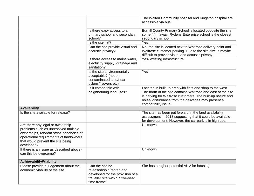
The Walton Community hospital and Kingston hospital are accessible via bus.
Is there easy access to a primary school and secondary school?
Burhill County Primary School is located opposite the site some 44m away. Rydens Enterprise school is the closest secondary school.
Is the site flat? Yes
Can the site provide visual and acoustic privacy?
No- the site is located next to Waitrose delivery point and Waitrose customer parking. Due to the site size is maybe difficult to provide visual and acoustic privacy.
Is there access to mains water, electricity supply, drainage and sanitation?
Yes- existing infrastructure
Is the site environmentally acceptable? (not on contaminated land/near pylons/flyovers etc)
Yes
Is it compatible with neighbouring land uses?
Located in built up area with flats and shop to the west. The north of the site contains Waitrose and east of the site is parking for Waitrose customers. The built-up nature and noise/ disturbance from the deliveries may present a compatibility issue.
Availability
Is the site available for release? The site has been put forward in the land availability assessment in 2018 suggesting that it could be available for development. However, the car park is in high use.
Are there any legal or ownership problems such as unresolved multiple ownerships, random strips, tenancies or operational requirements of landowners that would prevent the site being developed?
Unknown
If there is an issue as described above- can this be overcome?
Unknown
Achievability/Viability
Please provide a judgement about the economic viability of the site.
Can the site be released/sold/rented and developed for the provision of a traveller site within a five-year time frame?
Site has a higher potential AUV for housing.

What are the financial implications of this?
Can the development be funded/ afforded? What funding streams/grants can be sought?
Assuming that pitches are provided as affordable housing, then funding streams that could be sought include: • HCA grant – Affordable Homes Programme (2015- 18) • EBC Enabling Fund • EBC Capital Programme Would need a discussion with HCA as to likely contribution.
Will the release of this site for traveller accommodation be supported and prioritised by the Council?
Any ideas for seeking support and ensuring that this delivery is a Council priority?
Site size only 0.15 ha, so could make a limited contribution only.
Sustainable location, in terms of nearby amenities – so benefits for prospective residents.
Site does not appear to have the planning constraints that some others do.
Proposed use might be challenged on financial grounds (in terms of likely AUV for residential).
Deliverability
What is the time scale for delivery of the site?
Developable within 5 years
Developable in 6-10 years
Developable in 11-15 years
Developable beyond 15 years
Not deliverable / developable √
*Average Occupancy – 10:00 to 14:00 – Mon-Fri only Based on maximum occupancy across the 3x April, May, June 2017 sample weeks, at a given time. These maximum figures for each minute of the 10:00-14:00 period, then averaged to give an average occupancy for a car park.
The Result
The site is not considered deliverable/ developable due to its high use as a public car park, small size of the site and its compatibility issues with neighbouring uses.

Site Name: Hare Lane Car Park, 164 Hare Lane, Claygate, KT10 0RD Site Reference: U6
Key Information
Settlement: Claygate Ward: Claygate Site Area: 0.15 ha Current Land Use: Car Park (Sui Generis) How the site was identified: Elmbridge Borough Council – Asset Management & Property Services
Landowner: Public (Elmbridge Borough Council).
Figure 10: Aerial View - Hare Lane Car Park, Claygate
Site Description: The site is located off Hare Lane to the rear of the local shopping parade on the High Street. The site consists of a Council owned car park providing 43 spaces including 2 disabled bays. To the rear of the site is the ex-British Legion Building. This single-storey building is now used by as a martial arts centre. Surrounding the site is a number of residential properties of varying styles. The majority are large detached two-storey properties. To the east and south-east of the site is a number of retail properties located along Hare Lane and the High Street. There are a number of shops and services available in the parade further north of the site. Separating the site from Hare Lane is a small amenity space with a few trees and bench. The site is otherwise screened from the surrounding land-uses by brick walls and fencing with additional trellises. The site would allow for safe access for both pedestrians and vehicles and would allow easy and safe to access the strategic road network.
Planning History & Designations
Planning History: No relevant planning history. Designations:
• CLAY01 – Historic Centre Environs.
• Strategic View.
• Ground Water Vulnerability Zone 10km Buffer.
Designations within 20m of site boundary
• CLAY06 – Hare Lane, Oaken Lane & Telegraph Lane
Environs.

• Hare Lane & High Street are Planning Consultation ‘C’ Roads.
• Oaken Lane is a Planning Consultation ‘U’ Road.
• Claygate Village Conservation runs along the site’s eastern boundary.
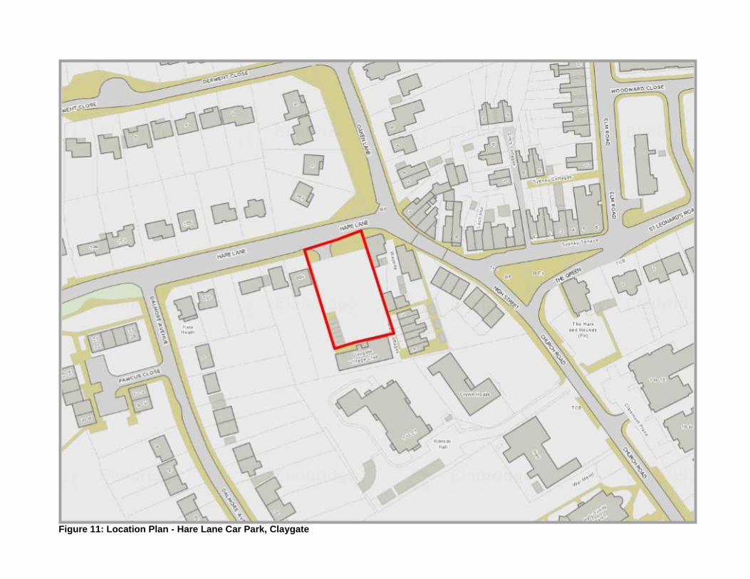
Figure 11: Location Plan - Hare Lane Car Park, Claygate

The Assessment
Assessment Criteria Additional questions Assessment Comments
Suitability
Is it a suitable location for development now?
Is the site large enough to accommodate pitches?
Could accommodate up to 4 pitches based on a double pitch size of 325m².
Does any of the site fall within Flood zone 2 or 3?
No
Any other environmental designation?
SANG 5km buffer
Does it impact on heritage or archaeology?
Abuts boundary of Claygate Village Conservation Area.
Will the land use need re- provision?
Yes- the community building would need to be relocated with parking facilities for this venue. The car park is currently underutilized at 30% average occupancy.
Is there safe and convenient vehicular and pedestrian access to the site?
There is safe access onto Hare Lane. Currently 6 houses and the community hall share the access. There is safe pedestrian access onto pavement.
Is there easy access to public transport?
Bus stop opposite the site (38m). K3 from Esher to Kingston operates a ‘good’ service. Claygate railway station is located 0.60km (6-minute walk)
Is there easy access to shops and services?
There is a 6-minute walk to the local shops on the parade. The K3 bus goes to Kingston, the regional shopping centre.
Is there good access to Hospitals, NHS GPs and dentists?
The closest NHS GP Surgery is at Elm Road 331m from the site, which is a 4-minute walk. The closest dentist is 418m away, which is a 6-minute walk. The K3 bus service goes to Kingston Hospital.
Is there easy access to a primary school and secondary school?
Closest primary school is Claygate Primary School, which is 0.80km away and takes 9 minutes to walk to. There is no secondary school in Claygate. The closest is in Hinchley Wood some 2.75km away. However, the K3 bus route stops at the school.
Is the site flat? Yes
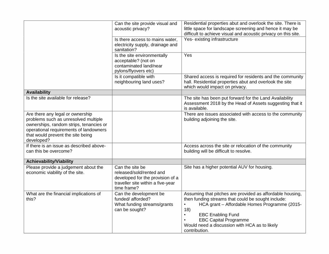
Can the site provide visual and acoustic privacy?
Residential properties abut and overlook the site. There is little space for landscape screening and hence it may be difficult to achieve visual and acoustic privacy on this site.
Is there access to mains water, electricity supply, drainage and sanitation?
Yes- existing infrastructure
Is the site environmentally acceptable? (not on contaminated land/near pylons/flyovers etc)
Yes
Is it compatible with neighbouring land uses?
Shared access is required for residents and the community hall. Residential properties abut and overlook the site which would impact on privacy.
Availability
Is the site available for release? The site has been put forward for the Land Availability Assessment 2018 by the Head of Assets suggesting that it is available.
Are there any legal or ownership problems such as unresolved multiple ownerships, random strips, tenancies or operational requirements of landowners that would prevent the site being developed?
There are issues associated with access to the community building adjoining the site.
If there is an issue as described above- can this be overcome?
Access across the site or relocation of the community building will be difficult to resolve.
Achievability/Viability
Please provide a judgement about the economic viability of the site.
Can the site be released/sold/rented and developed for the provision of a traveller site within a five-year time frame?
Site has a higher potential AUV for housing.
What are the financial implications of this?
Can the development be funded/ afforded? What funding streams/grants can be sought?
Assuming that pitches are provided as affordable housing, then funding streams that could be sought include: • HCA grant – Affordable Homes Programme (2015- 18) • EBC Enabling Fund • EBC Capital Programme Would need a discussion with HCA as to likely contribution.

Will the release of this site for traveller accommodation be supported and prioritised by the Council?
Any ideas for seeking support and ensuring that this delivery is a Council priority?
Small site size could make a limited contribution only.
Sustainable location, in terms of nearby amenities – so benefits for prospective residents.
Site does not appear to have the planning constraints that some others do.
Proposed use might be challenged on financial grounds (in terms of likely AUV for residential).
Deliverability
What is the time scale for delivery of the site?
Developable within 5 years
Developable in 6-10 years
Developable in 11-15 years
Developable beyond 15 years
Not deliverable/developable √
*Average Occupancy – 10:00 to 14:00 – Mon-Fri only Based on maximum occupancy across the 3x April, May, June 2017 sample weeks, at a given time. These maximum figures for each minute of the 10:00-14:00 period, then averaged to give an average occupancy for a car park.
The Result
The site is not considered deliverable/ developable due to its small site size, location of community building, location in built up area and associated privacy/overlooking issues.

Site Name: Land on the south west side of Claremont Lane (Berguette Car Park), Esher Site Reference: U7
Key Information
Settlement: Esher Ward: Esher Site Area: 0.154ha
Current Land Use: Car Park (Sui Generis) How the site was identified: Elmbridge Borough Council – Asset Management & Property Services
Landowner: Public (Elmbridge Borough Council).
Figure 12: Aerial View
Site Description: The site contain a small public car park to the north west of Claremont Lane a classified A road. To the north of the site lies the rear of Esher High Street and the secondary frontage to the District Centre. The east side of Claremont Road features a mix of uses from residential to offices and community uses. A flatted development and other detached residential properties front Claremont Lane to the south of the site. Waitrose car park adjoins and sits to the west of the public car park. The site does provide access to the strategic road network and could accommodate the required site selection threshold for pitches. It is in close proximity to shops and services and there is a bus service available for access to Kingston and Surbiton. The train station is located some half an hour walk away. The site is open in character with little boundary screening.
Planning History & Designations
Planning History: There is no planning history
Designations:
• ESH01 Esher District Centre
• A Road- Claremont Lane
• Minor HU
• Area of Archaeological Potential
• Esher District Centre
Designations within 20m of site boundary
• ESH03 Claremont Park and Clare Hill
• ESH02 New Road, Esher Park Avenue and Milbourne Lane • Esher Conservation Area

• Listed building- 3 (Friends Meeting House) Claremont Lane
• Designated Air Quality Management Areas 2013- Esher
• Secondary Shopping Frontage
• TPOs- EL:03/20 and EL: 11/16

Figure 13: Location Plan – Land of west side of Claremont Lane (Berguette Car park), Esher

The Assessment
Assessment Criteria Additional questions Assessment Comments
Suitability
Is it a suitable location for development now?
Is the site large enough to accommodate pitches?
Could accommodate up to 3 pitches based on a double pitch size of 325m².
Does any of the site fall within Flood zone 2 or 3?
No
Any other environmental designation?
SANG 5km buffer
Does it impact on heritage or archaeology?
On boundary of Esher Conservation Area and an Area of High Archaeological Potential.
Will the land use need re- provision?
Yes- public car park has an average occupancy of 96%*
Is there safe and convenient vehicular and pedestrian access to the site?
There is direct access to Claremont Lane (A244) which could present an issue in terms of manoeuvring large vehicles/caravans in and out of the site. The access point is narrow and located on a slope which could prove difficult to enter after exiting the A244. There might not be enough space to turn a caravan or mobile home on site. There is a very narrow pavement for pedestrians to access the site.
Is there easy access to public transport?
189 metres from a bus stop offering ‘good’ bus services 458, K3 and 715 to Kingston, Esher and Guildford. Esher Train Station is located 1.63km from the site.
Is there easy access to shops and services?
100 metres to shops and services in Esher district centre. Buses to regional shopping centres Kingston and Guildford.
Is there good access to Hospitals, NHS GPs and dentists?
0.84km from Esher Green Surgery (GP), which is a 12- minute walk away. 0.57km from a dentist, which is a 7-minute walk away. The K3 bus service goes to Kingston Hospital.
Is there easy access to a primary school and secondary school?
0.88km from Esher C of E Primary School, which is a 10- minute walk away. 0.84km from Esher High School (Secondary) which is a 9- minute walk away.

Is the site flat? No- the site has a slight slope.
Can the site provide visual and acoustic privacy?
Residential properties abut and overlook the site. There is little scope for landscape screening and hence it may be difficult to achieve visual and acoustic privacy on this site.
Is there access to mains water, electricity supply, drainage and sanitation?
Yes- existing infrastructure
Is the site environmentally acceptable? (not on contaminated land/near pylons/flyovers etc)
Yes
Is it compatible with neighbouring land uses?
Shared access is required for residents and businesses at rear of High Street. Residential properties abut and overlook the site which would impact on privacy.
Availability
Is the site available for release? Future use of 4 public car parks in Esher are being investigated. As this car park has an average occupancy of 96%, it is unlikely to be released for development without re-provision.
Are there any legal or ownership problems such as unresolved multiple ownerships, random strips, tenancies or operational requirements of landowners that would prevent the site being developed?
Businesses and residents of properties at back of high street access the car park for private parking. This could create a conflict of uses.
If there is an issue as described above- can this be overcome?
There are several landowners involved and hence seeking agreement over access would be difficult.
Achievability/Viability
Please provide a judgement about the economic viability of the site.
Can the site be released/sold/rented and developed for the provision of a traveller site within a five-year time frame?
No- it is not in the Asset Management Plan for release.
Site has a higher potential AUV for housing.
What are the financial implications of this?
Can the development be funded/ afforded? What funding streams/grants can be sought?
Assuming that pitches are provided as affordable housing, then funding streams that could be sought include: • HCA grant – Affordable Homes Programme (2015- 18) • EBC Enabling Fund • EBC Capital Programme
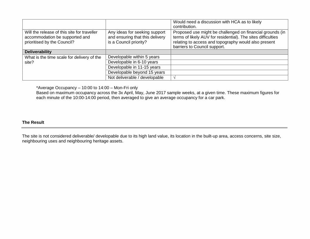
Would need a discussion with HCA as to likely contribution.
Will the release of this site for traveller accommodation be supported and prioritised by the Council?
Any ideas for seeking support and ensuring that this delivery is a Council priority?
Proposed use might be challenged on financial grounds (in terms of likely AUV for residential). The sites difficulties relating to access and topography would also present barriers to Council support.
Deliverability
What is the time scale for delivery of the site?
Developable within 5 years
Developable in 6-10 years
Developable in 11-15 years
Developable beyond 15 years
Not deliverable / developable √
*Average Occupancy – 10:00 to 14:00 – Mon-Fri only Based on maximum occupancy across the 3x April, May, June 2017 sample weeks, at a given time. These maximum figures for each minute of the 10:00-14:00 period, then averaged to give an average occupancy for a car park.
The Result
The site is not considered deliverable/ developable due to its high land value, its location in the built-up area, access concerns, site size, neighbouring uses and neighbouring heritage assets.

Site Name: Southbank Car Park, Long Ditton Site Reference: U8
Key Information
Settlement: Thames Ditton, Long Ditton, Hinchley Wood and Weston Green Ward: Long Ditton
Site Area: 0.22 ha Current Land Use: Car Park (Sui Generis) How the site was identified: Elmbridge Borough Council – Asset Management & Property Services
Landowner: Public (Elmbridge Borough Council).
Figure 14: Aerial View
Site Description: The site consists of a public car park which is accessible from Southbank off the Thorkhill Road. It contains 51 car parking spaces and 3 disabled car parking spaces. It is a rectangular shaped plot measuring some 86m in length and 25m wide. A row of residential terraced properties lie to the east of the site fronting Southbank, large detached and semi-detached properties lie south of the site with gardens backing the rear boundary. A mix of residential properties lies on the opposite side of Thorkhill Road and face the car park. There is a derelict public house and commercial building directly to the north of the site fronting Portsmouth Road. The site is flat and could accommodate 4 pitches even with some of the site in flood zone 2 which is at the far east of the site. The site is easy to access for pedestrians and vehicles and is easy and safe to access the strategic network. The site is located close to Surbiton and Kingston with good public transport to both locations.
Planning History & Designations
Planning History: No relevant planning history. Designations:
• DHW02-Thames Ditton, Giggs Hill Green & part of Long Ditton
• Flood Zone 2 up to 30m into the west of the site
• Major HU
• Ground water vulnerability drift 1.
• Strategic View

Designations within 20m of site boundary
• Thorkhill Road – Planning Consultation C Road.
• Southbank- Planning Consultation U Road.
• DHW07 Portsmouth Road & Riverside Environs
• Contaminated Land 07-2013 Factory or works

Figure 15: Location Plan –Southbank Car Park, Long Ditton

The Assessment
Assessment Criteria Additional questions Assessment Comments
Suitability
Is it a suitable location for development now?
Is the site large enough to accommodate pitches?
Could accommodate up to 4 pitches (minimum double pitch size of 325m²)
Does any of the site fall within Flood zone 2 or 3?
Section of the west side of the side falls within flood zone 2. This has been considered when assessing how many pitches the site could accommodate.
Any other environmental designation?
No
Does it impact on heritage or archaeology?
No
Will the land use need re- provision?
Car park is 58% utilized*. Alternative parking facilities would need to be provided.
Is there safe and convenient vehicular and pedestrian access to the site?
Yes. Off Southbank into Thorkhill Road and straight onto A307.
Is there easy access to public transport?
The site is within 120m of bus stops on the A307. Bus routes which are considered ‘good’ operate from these bus stops and include the 458 Kingston to Staines and the 715 Kingston to Guildford. Other bus routes available include the 514, 515 and 513 to Weybridge, Addlestone, Downside and Esher High School. The nearest train station is Thames Ditton which is 1.6km (1 mile) away.
Is there easy access to shops and services?
The site is located 0.71km away from the nearest local centre, Thames Ditton. The 515 bus provided an hourly service to the local shops at Thames Ditton. As explained above, all buses go to Kingston, the regional shopping centre.
Is there good access to Hospitals, NHS GPs and dentists?
The nearest NHS GP is at Thorkhill Surgery (0.59km)

Bus route 515 operates a service to Kingston Hospital. Th nearest dentist is located some 1.17km away and is accessible via the 515-bus service.
Is there easy access to a primary school and secondary school?
It is a 13-minute walk via Ewell Road to Long Ditton Infant and Nursery School, Ditton Hill Road, Surbiton. The 515 and K3 bus also travels there. The school is located 1km from the site.
It is an 11- minute walk via Ewell Road to Long Ditton St Mary’s C of E (Aided) Junior School (0.85km).
The site is located 1.64km from Hinchley Wood Secondary School. The K3 and 458 bus routes stop at the school.
Is the site flat? Yes
Can the site provide visual and acoustic privacy?
Residential properties neighbour the site so landscape screening would be required to provide acoustic and visual privacy. Limited space for landscape screening.
Is there access to mains water, electricity supply, drainage and sanitation?
Yes- existing infrastructure
Is the site environmentally acceptable? (not on contaminated land/near pylons/flyovers etc)
Yes
Is it compatible with neighbouring land uses?
Residential properties to the north, east, south and west of the site.
Availability
Is the site available for release? The site is not included in the Asset Management Plan as surplus and it has not been suggested for inclusion in the 2018 Land Availability Assessment.
Are there any legal or ownership problems such as unresolved multiple ownerships, random strips, tenancies or operational requirements of landowners that would prevent the site being developed?
Unknown
If there is an issue as described above- can this be overcome?
Unknown
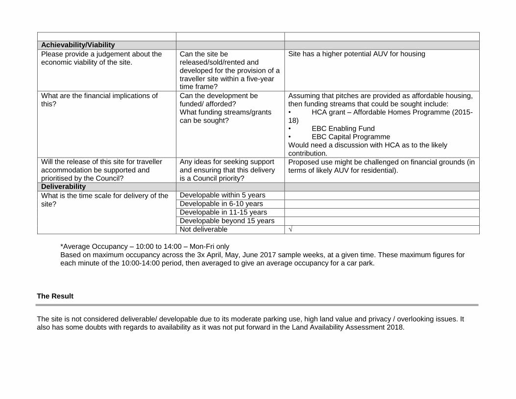
Achievability/Viability
Please provide a judgement about the economic viability of the site.
Can the site be released/sold/rented and developed for the provision of a traveller site within a five-year time frame?
Site has a higher potential AUV for housing
What are the financial implications of this?
Can the development be funded/ afforded? What funding streams/grants can be sought?
Assuming that pitches are provided as affordable housing, then funding streams that could be sought include: • HCA grant – Affordable Homes Programme (2015- 18) • EBC Enabling Fund • EBC Capital Programme Would need a discussion with HCA as to the likely contribution.
Will the release of this site for traveller accommodation be supported and prioritised by the Council?
Any ideas for seeking support and ensuring that this delivery is a Council priority?
Proposed use might be challenged on financial grounds (in terms of likely AUV for residential).
Deliverability
What is the time scale for delivery of the site?
Developable within 5 years
Developable in 6-10 years
Developable in 11-15 years
Developable beyond 15 years
Not deliverable √
*Average Occupancy – 10:00 to 14:00 – Mon-Fri only Based on maximum occupancy across the 3x April, May, June 2017 sample weeks, at a given time. These maximum figures for each minute of the 10:00-14:00 period, then averaged to give an average occupancy for a car park.
The Result
The site is not considered deliverable/ developable due to its moderate parking use, high land value and privacy / overlooking issues. It also has some doubts with regards to availability as it was not put forward in the Land Availability Assessment 2018.

Site Name: Mayfield Road Car Park, Hersham Site Reference: U9
Key Information
Settlement: Hersham
Ward: Hersham North
Site Area: 0.46ha
Current Land Use: Car Park (Sui Generis) How the site was identified: Elmbridge Borough Council – Asset Management & Property Services
Landowner: Public (Elmbridge Borough Council).
Figure 16: Aerial View
Site Description: The site consists of a public car park that is accessed via Mayfield Road. It is located to the south of the rail line and Walton train station. To the east, south and west of the site lies residential dwellings. The site is exposed to the north abutting the road but features some screening on the east and west boundaries. There are two tree preservation orders abutting the site at the south east boundary. The site is not close to a shopping centre but there is good public transport in terms of the train station and bus stop some 50m away. The site floor level is flat and there is already safe and convenient vehicular and pedestrian access to the site. There is also good access onto the strategic network from this site.
Planning History & Designations
Planning History: No planning history
Designations:
• Design and character Area HER04 West Grove Environs
• Ground Water Vulnerability MAJOR HU
• Thames Basin Heath SPA 7km Buffer
• Strategic View
• TPO EL:300
Designations within 20m of site boundary
• Planning Consultation U Roads- Mayfield Road
• Hersham District Centre
• Phone mast 2013- Mayfield Road • Contaminated Land 07/13- Mainline Railway

Figure 2: Location Plan- Mayfield Road Car Park
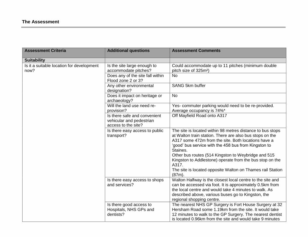
The Assessment
Assessment Criteria Additional questions Assessment Comments
Suitability
Is it a suitable location for development now?
Is the site large enough to accommodate pitches?
Could accommodate up to 11 pitches (minimum double pitch size of 325m²)
Does any of the site fall within Flood zone 2 or 3?
No
Any other environmental designation?
SANG 5km buffer
Does it impact on heritage or archaeology?
No
Will the land use need re- provision?
Yes- commuter parking would need to be re-provided. Average occupancy is 74%*
Is there safe and convenient vehicular and pedestrian access to the site?
Off Mayfield Road onto A317
Is there easy access to public transport?
The site is located within 98 metres distance to bus stops at Walton train station. There are also bus stops on the A317 some 472m from the site. Both locations have a ‘good’ bus service with the 458 bus from Kingston to Staines. Other bus routes (514 Kingston to Weybridge and 515 Kingston to Addlestone) operate from the bus stop on the A317. The site is located opposite Walton on Thames rail Station (87m).
Is there easy access to shops and services?
Walton Halfway is the closest local centre to the site and can be accessed via foot. It is approximately 0.5km from the local centre and would take 4 minutes to walk. As described above, various buses go to Kingston, the regional shopping centre.
Is there good access to Hospitals, NHS GPs and dentists?
The nearest NHS GP Surgery is Fort House Surgery at 32 Hersham Road some 1.19km from the site. It would take 12 minutes to walk to the GP Surgery. The nearest dentist is located 0.96km from the site and would take 9 minutes

to walk to. The nearest hospital is the Walton Community Hospital which is located 1.33km away from the site.
Is there easy access to a primary school and secondary school?
Bell Farm primary School is located 1.04km from the site and is a 14-minute walk. Rydens Enterprise School (Secondary) is located 0.93km away from the site and is a 9-minute walk.
Is the site flat? Yes
Can the site provide visual and acoustic privacy?
Some noise impact from rail line.
Is there access to mains water, electricity supply, drainage and sanitation?
Yes- established infrastructure.
Is the site environmentally acceptable? (not on contaminated land/near pylons/flyovers etc)
Close to railway
Is it compatible with neighbouring land uses?
There are residential properties to the east, south and west of the site.
Availability
Is the site available for release? Yes
Are there any legal or ownership problems such as unresolved multiple ownerships, random strips, tenancies or operational requirements of landowners that would prevent the site being developed?
No
If there is an issue as described above- can this be overcome?
No
Achievability/Viability
Please provide a judgement about the economic viability of the site.
Can the site be released/sold/rented and developed for the provision of a traveller site within a five-year time frame?
Site has a higher potential AUV for housing.
What are the financial implications of this?
Can the development be funded/ afforded? What funding streams/grants can be sought?
Assuming that pitches are provided as affordable housing, then funding streams that could be sought include:
• HCA grant – Affordable Homes Programme (2015- 18)
• EBC Enabling Fund

• EBC Capital Programme
Would need a discussion with HCA as to likely contribution.
Will the release of this site for traveller accommodation be supported and prioritised by the Council?
Any ideas for seeking support and ensuring that this delivery is a Council priority?
Site size 0.46 ha. So, could make substantial contribution. Sustainable location, in terms of nearby amenities – so benefits for prospective residents.
Proposed use might be challenged on financial grounds (in terms of likely AUV for residential).
Deliverability
What is the time scale for delivery of the site?
Developable within 5 years
Developable in 6-10 years
Developable in 11-15 years
Developable beyond 15 years
Not deliverable / developable √
*Average Occupancy – 10:00 to 14:00 – Mon-Fri only Based on maximum occupancy across the 3x April, May, June 2017 sample weeks, at a given time. These maximum figures for each minute of the 10:00-14:00 period, then averaged to give an average occupancy for a car park.
The Result
The site is not considered deliverable/ developable due to its high land value, its current use as a car park, its location in the built-up area and its proximity to the railway line with noise transference.

Appendix 3: Transit Site Proformas

Site Name: Cobham Motorway Service Area, M25 Junction 10 to Junction 9 Wisley, Surrey, KT11 3DB. Site Reference: T1
Key Information
Settlement: Cobham, Oxshott, Stoke D'Abernon and Downside Ward: Cobham and Downside Site Area: 5ha (North) for development 14ha (South) for access if site in fields to the rear.
Current Land Use: Motorway Service Station / access across. How the site was identified: Officer Suggestion Landowner: Extra MSA Cobham Limited.
Figure 1: Aerial View
Site Description: The Motorway Service Station is sited south of the M25 motorway and is located between junctions 9 and 10. The services are located on one side of the motorway, with an access ramp and tunnel used to access the site from the east bound carriageway. The whole site is located within the Metropolitan Green Belt. The land directly to the north is held under a rental agreement by Highways UK.
Planning History & Designations
Planning History: 1995/0601: Motorway service area providing restaurant, toilets, overnight accommodation, petrol/diesel forecourt, parking and picnic areas including access/egress slip roads with underbridge link serving both sides of motorway. Allowed by the Secretary of State.
Various planning applications have followed since regarding changes to original conditions, advertising consents, extensions to existing facilities and further HGV parking.
Designations:
• The entirety of the site is in the Green Belt (Strongly performing).
• Esher SANG 5km buffer
• SSSI Impact Risk Zone 2
Designations within 20m of site boundary
• The site is within the buffer area of the historic landfill site. • Within 2km of the Middleton Road Natural Greenspace.

Figure 2: Location Plan

The Assessment
Assessment Criteria Additional questions Assessment Comments
Suitability
Is it a suitable location for development now?
Is the site large enough to accommodate pitches?
Yes, the site to the north of the M25 could accommodate over 15 pitches and would provide space for livestock, facilities and an onsite management office.
Does any of the site fall within Flood zone 2 or 3?
No
Any other environmental designation? Strongly performing Green Belt
Does it impact on heritage or archaeology? No
Will the land use need re-provision? No
Is there safe and convenient vehicular and pedestrian access to the site?
Getting a 15m long caravan into the land from the slip road will need to be investigated. Consultation with Highways UK. On the M25 which is a strategic road network which is more suitable for a transit site.
Is there easy access to public transport? N/A for a transit site
Is there easy access to shops and services?
N/A for a transit site
Is there good access to Hospitals, NHS GPs and dentists?
N/A for a transit site
Is there easy access to a primary school and secondary school?
N/A for a transit site
Is the site flat? Yes
Can the site provide visual and acoustic privacy?
Noise from the M25 maybe an issue.
Is there access to mains water, electricity supply, drainage and sanitation?
No- this will need to be factored in.
Is the site environmentally acceptable? (not on contaminated land/near pylons/flyovers etc)
Noise from the M25
Is it compatible with neighbouring land uses?
Noise from the M25

Availability
Is the site available for release?
No
Are there any legal or ownership problems such as unresolved multiple ownerships, random strips, tenancies or operational requirements of landowners that would prevent the site being developed?
Rental agreement with Highways UK
If there is an issue as described above- can this be overcome?
No
Achievability/Viability
Please provide a judgement about the economic viability of the site.
Can the site be released/sold/rented and developed for the provision of a traveller site within a five-year time frame?
N/A
What are the financial implications of this?
Can the development be funded/ afforded? What funding streams/grants can be sought?
The funding streams that could be sought include:
• HCA grant – Affordable Homes Programme (2015- 18)
• EBC Capital Programme
• EBC Enabling Fund Would need a discussion with HCA as to likely contribution
Will the release of this site for traveller accommodation be supported and prioritised by the Council?
Any ideas for seeking support and ensuring that this delivery is a Council priority?
CMB have suggested the location for a transit site.
Deliverability
What is the time scale for delivery of the site?
Developable within 5 years
Developable in 6-10 years
Developable in 11-15 years
Developable beyond 15 years
Not deliverable Without ownership agreement the site is not deliverable.
The Result
The site is not available for access or development for traveller accommodation.
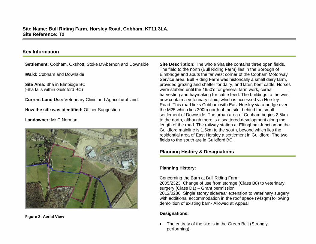
Site Name: Bull Riding Farm, Horsley Road, Cobham, KT11 3LA. Site Reference: T2
Key Information
Settlement: Cobham, Oxshott, Stoke D'Abernon and Downside
Ward: Cobham and Downside Site Area: 3ha in Elmbidge BC (6ha falls within Guildford BC) Current Land Use: Veterinary Clinic and Agricultural land.
How the site was identified: Officer Suggestion
Landowner: Mr C Norman.
Figure 3: Aerial View
Site Description: The whole 9ha site contains three open fields. The field to the north (Bull Riding Farm) lies in the Borough of Elmbridge and abuts the far west corner of the Cobham Motorway Service area. Bull Riding Farm was historically a small dairy farm, provided grazing and shelter for dairy, and later, beef cattle. Horses were stabled until the 1950’s for general farm work, cereal harvesting and haymaking for cattle feed. The buildings to the west now contain a veterinary clinic, which is accessed via Horsley Road. This road links Cobham with East Horsley via a bridge over the M25 which lies 300m north of the site, behind the small settlement of Downside. The urban area of Cobham begins 2.5km to the north, although there is a scattered development along the length of the road. The railway station at Effingham Junction on the Guildford mainline is 1.5km to the south, beyond which lies the residential area of East Horsley a settlement in Guildford. The two fields to the south are in Guildford BC.
Planning History & Designations
Planning History: Concerning the Barn at Bull Riding Farm
2005/2323: Change of use from storage (Class B8) to veterinary surgery (Class D1) – Grant permission 2012/0286: Single storey side/rear extension to veterinary surgery with additional accommodation in the roof space (94sqm) following demolition of existing barn- Allowed at Appeal Designations:
• The entirety of the site is in the Green Belt (Strongly
performing).

• Esher SANG 5km buffer
• Thames Basin Heath Special Protection Area 400m -5km
• Land to the east in a Biodiversity Opportunity Area (Clandon to Bookham Parkland)
• SSSI Impact Risk Zone 2
• Grade 3 agricultural land
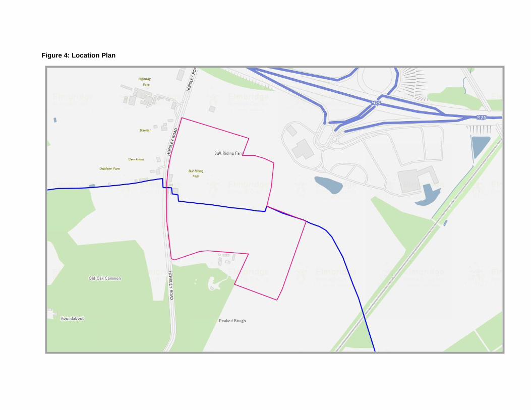
Figure 4: Location Plan

The Assessment
Assessment Criteria Additional questions Assessment Comments
Suitability
Is it a suitable location for development now?
Is the site large enough to accommodate pitches?
Yes, the site could accommodate over 15 pitches and would provide space for livestock, facilities and an onsite management office.
Does any of the site fall within Flood zone 2 or 3?
No
Any other environmental designation? Strongly performing Green Belt. Esher SANG 5km buffer Thames Basin Heath SPA 400m -5km SSSI Impact Risk Zone 2 Grade 3 agricultural land Biodiversity Opportunity Area
Does it impact on heritage or archaeology?
No
Will the land use need re-provision? No
Is there safe and convenient vehicular and pedestrian access to the site?
Access is needed though the Cobham Motorway Service Station so that caravans and vehicles can access the M25 safely. There is some concern about how this could be successfully incorporated into the service station.
Is there easy access to public transport? N/A for a transit site
Is there easy access to shops and services?
N/A for a transit site
Is there good access to Hospitals, NHS GPs and dentists?
N/A for a transit site
Is there easy access to a primary school and secondary school?
N/A for a transit site
Is the site flat? Yes
Can the site provide visual and acoustic privacy?
Visual privacy can be achieved. There may be some noise from the M25 and the services, which would require acoustic privacy measures.

Is there access to mains water, electricity supply, drainage and sanitation?
There is no existing infrastructure on the site.
Is the site environmentally acceptable? (not on contaminated land/near pylons/flyovers etc)
Noise from the M25
Is it compatible with neighbouring land uses?
Noise from the M25
Availability
Is the site available for release? Owner is not interested in development.
Are there any legal or ownership problems such as unresolved multiple ownerships, random strips, tenancies or operational requirements of landowners that would prevent the site being developed?
N/A
If there is an issue as described above- can this be overcome?
N/A
Achievability/Viability
Please provide a judgement about the economic viability of the site.
Can the site be released/sold/rented and developed for the provision of a transit site?
N/A
What are the financial implications of this?
Can the development be funded/ afforded? What funding streams/grants can be sought?
The funding streams that could be sought include:
• HCA grant – Affordable Homes Programme (2015- 18)
• EBC Capital Programme
• EBC Enabling Fund Would need a discussion with HCA as to likely contribution
Will the release of this site for traveller accommodation be supported and prioritised by the Council?
Any ideas for seeking support and ensuring that this delivery is a Council priority?
CMB have suggested the location for a transit site.
Deliverability
What is the time scale for delivery of the site?
Developable within 5 years
Developable in 6-10 years
Developable in 11-15 years
Developable beyond 15 years
Not deliverable Without ownership agreement the site is not deliverable.

The Result
The site is not available for development.

Site Name: New Barn Farm, Bookham Road, Downside, Cobham, KT11 3JS. Site Reference: T3
Key Information
Settlement: Cobham, Oxshott, Stoke D'Abernon and Downside Ward: Cobham and Downside Site Area: 8 ha in total Current Land Use: Agricultural and Sui Generis (Dog day care business) to land west of site.
How the site was identified: Officer Suggestion Landowner: Ms Young.
Blue line is the Borough boundary Figure 5: Aerial View
Site Description: There are 2 parcels of land. 1 to the west of the Cobham Motorway services and 1 to the south of the services, which includes two open fields. Some of the land to the west of the site is used for a dog day business as well as open field. This site is accessed by a single-track road which leads to Horsley Road on the west site boundary.
Planning History & Designations
Planning History: 2016/4069: Retrospective application for change of use from Agricultural to Agricultural and Sui Generis for dog day care an retention of portable cabins and 1.6m high fencing associated with dog day care use. Designations:
• The entirety of the site is in the Green Belt (Strongly performing).
• Esher SANG 5km buffer
• Thames Basin Heath Special Protection Area 400m- 5km buffer
• SSSI Impact Risk Zone 2
• Grade 3 Agricultural Land
• Land to the east in a Biodiversity Opportunity Area (Clandon to Bookham Parkland)

Figure 6: Location Plan

The Assessment
Assessment Criteria Additional questions Assessment Comments
Suitability
Is it a suitable location for development now?
Is the site large enough to accommodate pitches?
Yes, each parcel of land could accommodate over 15 pitches and would provide space for livestock, facilities and an onsite management office.
Does any of the site fall within Flood zone 2 or 3?
No
Any other environmental designation?
Strongly performing Green Belt SANG Esher 5km Thames Basin Heath Special Protection Area 400m- 5km buffer Grade 3 Agricultural Land Land to the east in a Biodiversity Opportunity Area (Clandon to Bookham Parkland)
Does it impact on heritage or archaeology?
No
Will the land use need re- provision?
No- due to the size of the fields, it is unlikely to impact on the dog day care business.
Is there safe and convenient vehicular and pedestrian access to the site?
Access is needed though the Cobham Motorway Service Station so that caravans and vehicles can access the M25 safely. There is some concern about how this could be successfully incorporated into the services design.
Is there easy access to public transport?
N/A for a transit site
Is there easy access to shops and services?
N/A for a transit site
Is there good access to Hospitals, NHS GPs and dentists?
N/A for a transit site
Is there easy access to a primary school and secondary school?
N/A for a transit site

Is the site flat? Yes
Can the site provide visual and acoustic privacy?
Noise from the M25 maybe an issue.
Is there access to mains water, electricity supply, drainage and sanitation?
No- this will need to be factored in.
Is the site environmentally acceptable? (not on contaminated land/near pylons/flyovers etc)
Noise from the M25
Is it compatible with neighbouring land uses?
Noise from the M25
Availability
Is the site available for release? Owner is positive about development, but this relates to highway provisions and working with MSA.
Are there any legal or ownership problems such as unresolved multiple ownerships, random strips, tenancies or operational requirements of landowners that would prevent the site being developed?
Unknown
If there is an issue as described above- can this be overcome?
Unknown
Achievability/Viability
Please provide a judgement about the economic viability of the site.
Can the site be released/sold/rented and developed for the provision of a traveller site within a five-year time frame?
N/A
What are the financial implications of this?
Can the development be funded/ afforded? What funding streams/grants can be sought?
The funding streams that could be sought include:
• HCA grant – Affordable Homes Programme (2015- 18)
• EBC Capital Programme
• EBC Enabling Fund Would need a discussion with HCA as to likely contribution
Will the release of this site for traveller accommodation be supported and prioritised by the Council?
Any ideas for seeking support and ensuring that this delivery is a Council priority?
CMB have suggested the location for a transit site.
Deliverability

What is the time scale for delivery of the site?
Developable within 5 years
Developable in 6-10 years
Developable in 11-15 years
Developable beyond 15 years
Not deliverable Without ownership agreement from the Motorway Service Station, the site cannot gain access and so is not deliverable.
The Result
The site is not available for development due to the MSA not allowing access across their land.