h> 7 f - gmw.consrv.ca.govgmw.consrv.ca.gov/shp/apsi_siteinvestigationreports_ocr/apsi_0… ·...
TRANSCRIPT
I, ~ _ h> ...... ...,,._....Jn.;_,c=sc:r...-iL....__~7 b et..d.. ..
f a.,_.......:...., . -
~r~ - ~· .. I'~ ~ '17'-- ~
~ 0,f<;; ~ _,_ ?···~ ~
~ ""'-- ~- l"J ( ~ ~:..y)
~ rn..P-- "~ ,;:t:;.;__. I~ -vc.-e,,,..'.-S
~. . . . .;---'-~ ~ ........-~ ~ •.. '.' .,.!.. ~' ~ ~ V<. ,(,< .. :ot., ~ ~ 7=~ 1""k. •1 o) I : ....
,. ~~-" ,.,,;~ ~ L. .. ..X.:.... • . -V" - ,._ ~ • , e.. .........,... r v --- --7-
2, ~~~ ~':~.c~. ~ ~ ,..,......._.:..... c~ ,:... 0 f::, ~
~ ---r It-<... ~ ~ ~ ~.,.......
~- ~~ fvr..... Aly ~. Rx-~ ' ' ·I ,.. ,-
~ ~ c_ ,~1--J~ ,,:__· ·~~-~. "I~ .. :t.,.. IV<~~ ~
rv~~ ~c. ... ;....c q_ ~?---. ~ ~
lr.,,,y~ ~ ~.
' ( • _f . ,

.. _---~-~_;:1~ ' ' ".-J'. ' .- ~- - '* ·~&iPI~<~"'' --STATE OF CALIFORNIA
STD. FORM 118 (REV. 7•72.l 6. OSP
FROM:
- ;'
FOR ACTION AS. JNDICAIED· _ 0 -REPi.Y~Y SIO~tuft 0 REPLY-COPY TO ME
0 PLEASE SUMMAR.tZE
0 PlEASE INVESTIGAT£ _ ·
[l"FoRWARDED- PER Ri:QU.E:ST
REMARKS:
£1•• D APPROVAL
D ACTION
QCOMMENTS
0 lNFOl/MflON .
PHONE
·~-~2;; 0 NOTE AND fl LE
0 NOTE ANO R~TURM
Q: tlEASE PHONE ME
EJ PLtASE S~~ ME
21ul'~ -Arttdf

-.·. -STATE OF CALIFORNIA-THE RESOURCES AGENCY
DEPARTMENT OF CONSERVATION
DIVISION OF MINES AND GEOLOGY DIVISION HEADQUARTERS RESOURCES BUIL01NG, ROOM 1341
1416 NINTH STREET
SACRAMENTO, CA 95814
District Offic:es: LOS ANGELES
Junipero Serro Bldg., -Rm. l 065 l 07 South Broadway 90012
SACRAMENTO
Resources Bldg., Rm. 118 1416 Ninth Street 95814
SAN FRANCISCO
Ferry Building 94111
March 31, 1975
Mr. A,R. Turturlcl Director of Public Works City of San Jose Room 308, City Hall San Jose, California 95110
Dear Mr. Turturlcl:
RONALD REAGAN, Gover11or
We are placing on public file the following report, resubmitted March 18, 1975 and approved In accordance with the Alqulst-Prlolo Geologic Hazard Zones Act:
Moxley Single lot Homeslte, AP 595-21-016, lot 20, Rancho View Court, City of San Jose -- Geologic/Seismic Refraction Report.
EWH/mkr
cc: State GeologlstJ.""""
Sincerely yours,
EARL W. HART Geologist San Francisco District Office

• -· .-CITY OF SAN JOSE CALIFORNIA
..
801 N. FIRST ST.
IAN JOSE: CA 95110 TELEPHONE 1408) .2.77~4000
Room 308, City Hall
DEPARTMENT OF PUBLIC WORKS 18 March 197 5
California Division of Mines and Geology Ferry Building San Francisco, CA 94111
ATTN: Mr. Earl Hart
Re: Geologic Investigation of Moxley Homesite, Lot 20 of Assessor's Parcel 595-21-016• Santa Clara County (Previously submitted February 28, 1975)
Dear Mr. Hart:
Enclosed is a_Special Studies Zone Geologic Report for a homesite in San Jose's eastern foothills. The report was refused under the previous submittal "until reviewed and approved by a registered geologist on behalf of the City ..• " (Earl W. Hart to A. R. Turturici, 3/10/75).
This report was reviewed and approved by the City's staff geologist, Willard Todd Nelson, registered geologist 2641, whose signature appears below.
The other report (Daniel J. Rhodes and Associates for Presley Development Co;-; ___ at Story Road and Machado Lane) will be returned separately when it has been signed by the reviewin9 engineering geologist, Jeremy C. Wire, and when Mr. Wire s geologist registration number has been indicated on the report. ·
v ERT:TN:bc
A. R. TURTURICI Director of Public Works
:£~..__··_LZ __ · E. R. TOSCH! Prine. Civil Engineer Engineering Services Division
Encl. Geologist Report
Reviewed by: Willard Todd Nelson Geologist 2641 //, .. -ff;:? !:/:C ~ cj ?J.;;r.'£;/ ;Ytc{;'C'.-i;.t_.

R. Bu.Ion Ros€, MA. GEOLOGIST
ENGINEERING GEOL.OGlaT
'CAL.11"0,.,.,.IA Al:~+SiT .. ATlON)
ALLIED GEOPHVSICS
P.O. Box !583 SAN ..IO&E, CA. 95tOa \406) 2!SS-2.698
Moxley Single Lot Homesite
AP 595-21-016 Lot 20
Rancho View Court
East of Piedmont Road
between Cropley and Crosley Creeks.
City -Of San Jose
Geologic/Seismic Refraction
Report

R. Burlon Ro>e, MA GEOL.OG1ST
ENGINEE:R:NG Gs:OLOOIST (C'°'Llf'"ORr.IA Rl!;Gl&TlllATION)
ALLIED GEOPHYSICS
P.O. Box !583 SAN JOSE. CA. 9510• (408) 2S8·269S
Mr. Bruce Moxley 3455 Outlook Drive San Jose, California
Dear Mr. Moxley:
February 22, 1975
Ti..--1. •·-·· •-- .&.!,.....- _ _.. ___ _..,,_: .... _,: -.a.. .. .-1 •. : __ rllQllr\ yvu IVI '-1111: Ut-Jt.JVI L.\,.Hll t..Y VI .;:)\,.U\JJlllY
and reporting on the geologic and seismic aspects of building on your east side land parcel AP 595-21-016, ioca"ea on Rancno v1ew ~ourt.
The accompanying report delineates both the geologic data and summary seismiclty: augmented with a detail seismic refraction line placed across your lot.
The location Is on a broad westerly sloping crest between the drainage courses of Cropley and Crosley Creeks: a cut pad site fn a partly developed existing sub-division.
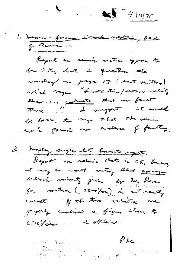
The lot lies within one of the Alaulst-Frlolo Special Studies (Fault) Zones as shown on the excerpt from the July overlay, 1974, on the Calaveras ~eservolr topographic auacran~le. It lies between the Crosley fault trace 6CO feet westerly and :ne ~erryessa fault trace ('l) 300 feet easterly •. ::;wrf2ce sci I Is underlain by average velocity of 52CO ft.;se~. becrcck, iraicating a stable consolidated bedrock with Its upper horizon dipping towarcs the west (seismic refraction exaggerated vertical scale x~section).
From a geolo·,Jic and seismic vi e.',.point, latest edition uac design standards shculd provide an adequate safety factor, using an acceler2tion figure of 0,15 g.
Respectfully su8mitted,
R.. Sur t c n 'ic s e ::c::;76c ~;f'397

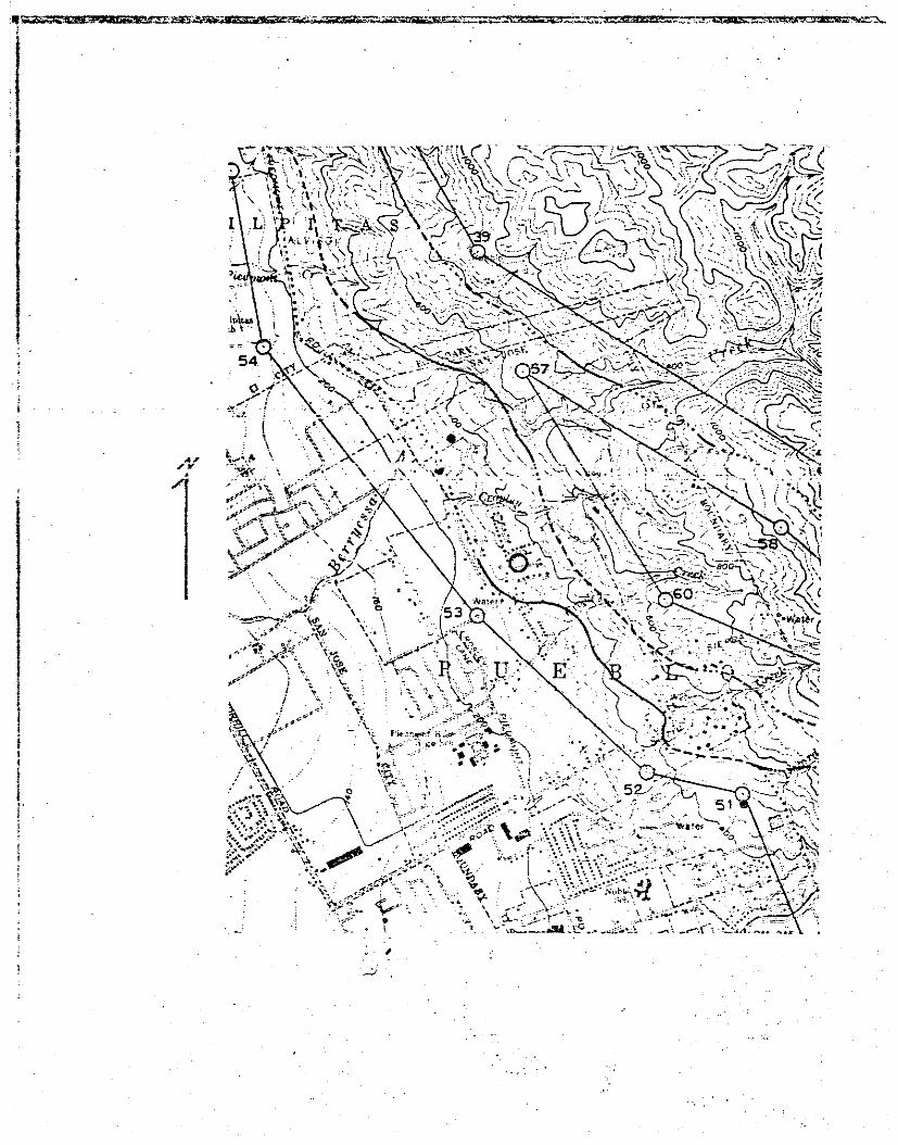
Moxley Single Lot Homesite
AP 595-21-016 Lot 20 Rancho View Court, San Jose CA
Between Cropley and Crosley Creeks East of Piedmont Road
Approximate scale 1 In. = 500 ft.
Area Aerial View

Calaveras Reservoir quadrangle, 1:24,ooo (1968)
Contour interval 40 ft. 0 AP595-21-016
Pueblo Lands of S2 n Jose Scale 1

Moxley Single Lot Homesite
Rancho View Court, San Jose CA
Between Cropley and Crosley Creeks East of Piedmont Road
Approxl~ate scale 1 in. = 500 ft.
Property Outllne Wa_£
(from Santa Clara Co. Cadastral Wap 37, Jan. 1974)
R. Burian Rose, MA GEOLOGIST
ENGINEERING GEOLOGIST
(CA~!ll"OFtNIA REGISTllllATION)
ALLIED GEOPHYSICS
P.O. Box 593 SAN JOSE. CA. 9!!noa (408) 25B-26QB
In-depth Geologic-Seismic Study
Moxley Single Residence Lot
Santa Clara Co. Assessor #AP 595-21-016 (Lot 20)
r,..,,+r.• C'"...,,hr-11~r-u ".>"=> 1071: ~· • ............ _.J ... ._, .,.,, • ..,,
introducl.ion;
This study purpose Is to evaluate the described parcel lot
for Its projected use as a single residence wood framed
home structure. Both the geologic and seismicity hazards
and conditions are reviewed, with probabl lity considerations
a pertinent factor. Part of one day was spent at the site
and surrounding public acc~ss areas, including running one
.100 foot length seismic refraction line across the lot. It
should be noted that this lot is a surveyed portion of an
.!xfsting, partly built up''9U8"Jtll&NJwith an;xlsttng
-cut bufldtng pad;
Location:
This recorded land plot is situated in the east hil Is of
Santa Clara Valley, in Township 6 South, Range 1 Eas't,
Pueblo Lands of San Jose; being on the north side of
Rancho View Court and east of Canyon View Drive, easterly

595-21-016 2.
of Piedmont Road. The entire plot lies within the 1974
Alquist-Priolo Special Studies zone.
Data:
The essential geologic, structural, seismic, fault, slope,
and topographic information, with a seismic refraction
survey plate, are placed ahead of the bibliography. An
appendix group of related reference perspective data is
attached for better overall understanding.for the client.
This written summary attempts an overal I basic evaluation.
The reverseo reao1ngs se1sm1c retraction Time-Distance
graph with its resultant computed field ground velocltfes
encountered is shown with the Interpretive cross section
profile. Velocities are in feet l)er second. The time Is
In milliseconds. Elevation of the site is 320 feet.
General Geology:
This specific lot is covered with an t¥"9a.ftl-V··Sllt+"'man't'~ <;f'>-.-
with a sllght~esterly dfppfn~contact to the underlying
'Uurassic age sheared o~ (Dibblee 1972) (f) comprising
well consolidated {average seismic velocity ~ft.~.-...)
'stiales and sandstone. ·A contact to tntrustll'!!" serpentfne
:·tfes between the s·fte and the Crosley fault trace to the
~&t't TM··Serryessa fault trace I fes approxfmatef·y BOO·"'
"·•~· tO' tM eaofjl bounded on its east side by Cretaceous
age Oakland congl.omerat.~ a marine cobble and boulder
sedimentary deposit. These are two of the minor faults

595-21-016 3.
cutting the eastern foothill area. They are part of
the Hayward fault rift zone as now mapped (Dibblee 1972),
being a south extension of the previously mapped northerly
trace of the Hayward fault In the north of Warm Springs.
The other major fault on the east side of Santa Clara Valley
is the Calaveras rift zone lying 4000 feet north easterly.
The third and greatest fault rift zone, the San Andreas,
strikes thru the Santa Cruz mountains west of Los Gatos and
Saratoga. Future major earthquakes mu~t be e~pecteci with
epicenters along the three rift systems. Shorter faults
generate much less shaking energy ('Wiegel 1970, Table 4.1).
Landslide Potential:
t:amtstlttin9 is regarded as mlnfmal In probabl I lty at this
site because of the •¥f9ht.ly cUpplrr9 Sf'CJlll!llrand the thtn
tow vek>cfty soi I mantle e>verJyi~ the high velocity be~""
North east of the site and easterly of the Berryessa fault,
a small landslide (Qls) has been mapped where the slope fs
steeper and lies close to the Cropley Creek incised ravine.
It Is Important that both utility service water and sewer
facilities are exlsting in this development. Surface runoff
Is effectively controlled by the paved curbs and streets.
Seis~ic Conditions and Hazards:
Regional severe earthquake shaking must be anticipated In . . .
structural des!gri and living; being adjacent to traces of
the.Hayward fault, but ·not within the 5o·foot Alquist-Priolo

I
'
595-21-016 4.
trace to living structure setback. An acceleration
factor of 0.15 g. should be sufficient for single family
wood frame structure. Curbs and gutters close to the lot
were inspected without finding cracks or offsets resulting
from surface creep along a fault trace.
Conclusions:
In resume, these summary evaluations and recommendations,
together with the accompanying maps and reference data,
Indicate that a suitable home structure can be designed
wi"tnln tne lat.est Utl(.; code regulatbns; frorr a qeolociic
and seismic viewpoint.
Seismic Refraction Data:
This explorator~ testing provides depth Information to a
depth of 1/3 to 1/4th the tot a I I ength of the survey Ii ne.
Velocities less than 2000 ft./sec. indicate soil mantle.
Velocities above 6000 ft./sec. are difficult to impossible
to rip: hence indicate stable equivalent bedrock, a factor
that minimizes both the Intensity and duration of shaking
and resultant carnage from an earthquake. A Bison Model
1570B signal enhancement selsmograch was used in the field.
3 copies City of San Jose 1 copy l/r. Bruce l/oxley 1 copy office file
Respectfully submitted,
~~~~ R. 3urton Rose, 11.A.
CEG760 GP397

~oxley Single Lot Homesite
Rancho View Court, San Jose CA
Between Cropley and Crosley Creeks East of Piedmont Road
~ \\ _\ __ ------.. Approximate scale 1 ln. = 500 ft.
To~oaraphy and Soils
(from US~S Calaveras Reservoir 1:24000 quacrang!e and us Dept. Agriculture "Soils of 0ant:J. C!:;ra C~:..:~ty C.'1 .• ~96::1)

Moxley Single Lot Homesile
Rancho View Court, San Jose CA
Between Cropley and Crosley Creeks East of Piedmont Road
\ \
\~ ...... ~\ \ ,t~ - __ ,
\ \
\\\ \ '- \
. ....:. \
-Approxi~ate scale 1 in. = 500 ft.
Geologv and Structure
(area data from Qlbb:ee 1972)

Soi Is:
Ac£2
CnD
Geology:
Legends:
Altamont clay (slopes 15 to 30 %l eroded, moderate sneet erosion, Includes some small landslides, underlain by soft to hard type sediments, usually neutral to alkaline, cracks deeply when dry, well drainea
Climara clay (slopes 9 to 30 %) scattered ~ro~Q nT IP~~or ~lnnP~ wet I rl~~in~rl- nvPrllP~ -·--- -· ·----· -·-~-- .. ··-·· ---·· --~ --------metamorphosed basic igneous rock usually, well aralned, medium runoff, moderate erosion, -:--- -·--- ---~--· __ _, ---·- --··-----ll!lllU! ~l.Vllt:: \..Vlll..t:'lll.. 0..llU I 1.11..-,..., VU\.""I VtJo;>
Qal Recent alluvium, sediments Including gravel, sand, silt, and. clay
Qls Landslide debris of mixed rock ages and times of original movement
Qsc Pleistocene Santa Clara formation, slightly consolidated non-marine sediments including full rar:ige of material sizes as cited with a I I uv I um
Ksh Upper Cretaceous age snale (micaceous) Berryessa formation; sandstones, slltstones included as thin lenses
Keg Cretaceous age Oakland conglomerate, marine sedimentary source, cobble and boulder conglomerate mixeo with finer matrix
f Jurassic a;e (possibly Knoxvi I le) Franciscan thoroughly sheared rock structure, shales, sandstone, graywacke

i 'l I I ··- ...,,·
' r.~ {' - 1·1 --~... or ~! ~tl.+.,! }'(J-J
I f·-.J'.3T F":Uivil.::;-.n s 5703 · 2Gth Str:::!~ v·:":i:t 21. I uuis C'.:i L, f\~:nn. f;~},116
I L
. :i
.. i
V;, • P2<7t:I ,,..l'f, "'f"· ! ' .
A-.a
' ' '
I

'.
, ;/
Book 595 page 21 Parcel 016
,y
1 I
1"=100'
;:·JJ. ~ T: T: (J ~~ ::·· F T t-1 ~ :_ ~ ~~ O S 0 F- J\.~ ~ ~ ! A J C· S E F ..'l 3 ~: ~ ~:YES SA ~ T. A~-·=;-:.-:.:=_;---=- ::-=--::· ·.-;--:-::-_-_;.·.-~-=-·==-:-=-:·-:..::-::::::=:~..=-.:-.;:::-~-=~-::::::;-_: -~:-- ;-.,~_;-==._:: __ :-_:·=.:·_:___c..=--- - -:::~~"::".:..-
----···--·
/.;:' '· 22 /, ... ·l)'i
/ \ I ,,/ \"-.._ '
v \~·
29
' 26 ,. \ - . \.:!. '" ~1 ..
:; I ·I
"'\ I
I I
'
\
;
'1. ')It -·
--
ib-7/;1 -' ~ 5
/
!
, I Is
")'-. :---: ~.:.-:
,, • .JI_-..;. - .,,, ,.:
' - ·- ~ c . . ,
17 t, .. ·s
/5
~----· .;.s.;..s _ _.h"°'.-:·.,·.·-·· .. :;"'J);...._'._./~"··...,'.lf .. ~1
'----c"'"-' ------'-": ___ ..;;..· -'-'
RANCHO VIEW co
1
9
TRACT N~ 3462 R
Mr. Bruce Woxley Parcel
Seismic Refract~cn Lire
Bibliography
California Division of Mines & Geology: Prel. Rept. 18 (1973)
Solis of Santa Clara Co: US Department of Agriculture Soil Conservation Service (1968), with Aerial Sol I Map #12, Santa Clara Co., CA., 1 "=1000'
Geology of the San Jose-Mount Ham! I ton Area, CA, Crittenden, Max o., Jr.: State of California, Dept. of Natural Resources, Bui letin 157 (1951) p. 57 & maps
Geologic Guidebook of the San Francisco Bay Counties: California Division of Mines, Bulletin 154 {1951)
Proceedings of Conference on Geologic Problems of the Q~r'I A-....-"r~~c- C"·.'l'••t• -~t1c+a ..... • -Q.+.-..-;-F,......-rl ·r1,...,,;\..-..., ... -<'::'~+" ·c:ac·ef-r•.-nc ...,....,,, .,.,''-"' ._ .... ...., • ..,.....,, ... ...,,, """"'-"'• ........... ,,. ""•"" ""''·• • '-' '""'' ... J ... ._._ .... • ,....,,...,,
Publications/Geological Sciences, vol. XI {1968) (1973)
Geoiogy oi Northern Caiifornia: 8ui iecin 1:io, 1;a1norn1a U1v1sion of Mines and Geology, pp. 307-308 & p. 362 ( 1966)
Urban Geology - master plan for California: Bulletin 198, Cal ifornla Division of Mines and Geology, p. 20 ( 1973)
Preliminary Photointerpretatlon and Damage Maps of Landslide and other Surflcial Deoosits In Northeastern San Jose, Santa Clara Co., CA: U~GS map MF-361 {1972)
Environmental Geolog\c Analysis Santa Cruz Mountain Area, Santa Clara County, California, Thomas H. Rogers: State of Calif., ::>iv. or Mlnea and Geology, Spec. Publ. (1971)
Maps:
u.s.G.S. topographic map 1:24,000, Scale 1" = 2000 I * Geologic Map of California: San Jose and San Francisco
sheets, 1:250,000 (Regional)
*Calaveras Re::;ervolr quadran:il e (1968 photorevlslo.:i)
Geologic Map of the Calaveras Reservoir quadrangle: Dibblee! Tnomas ·.v. ·~1r., u.s.s.s. (open ·file 1973) 1 : 24' 000

Selsmlclty
Plates -- Data

---- --- -----------
CONTOLIR INTERVAL 40 FEET DOTTED LINES Pt.PRESENT 10-FGCT CONTOURS.
DATUM, I~ t"1EAN SEA L.EVEL
..
STATE OF CALIFORNIA.
SPECIAL STUD~ES ZOi..JES Delineated In compliance with
Chapter 7.5, Division 2 of the California Public Resources Code
CALAVERAS RESERVOIR QUADRANGLE
OFFICIAL fJlAP
Effective: July 1, 1974 ·
k?L~ 9 ~ State Geologist
··~ . U.:· .. . ..
. " " . . ..
. ....
i
'
I I i
I .Ll
lp\t.a :h \
,

..•
10 0 IO 20 f'lfLIES
/
D. H. Re.dbruch
"1
<So
< ol
1~T A.W-1 -1-
~ R~tt""1tr (;'
~
I Figure 5.--Index map sl1o-wing approxWate location of Cala·veras~ Hayvard, and San Andreas fault zones.
51
..
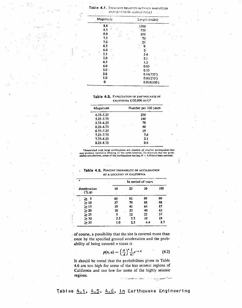
Table .4.1. IDrAUZ£D RELA1~0~ st:Tv:rr:-.: ~AGsrr..:oE A'.'D Ll'-GTH OF SLLf'P!:O fAL:LT
~fagriitud~ Length {rnilc:;) -~-'-,~-~-----~ ---
8. 8 8.5 8.0 7.5 7.0 6.5 6.~
5.5 5.0 4.5 4.0 3.0. 2.0 1.0 0
1000 . 530
190 70 25 9 > 3.A
2.J 1.3 0.83 0.33 0.1~(7351
0.05(270') 0.018(100')
Table 4.5. EXPECTATION OF EARTHQCAKES IN
CALlfORSIA (150,000 mil)*
Magnitude
4.75-5.25 5.25-5.15 5.75-6.25 6.25-6.75 6.75-7.25 7.25-7.75 7.75-8.25 8.25-8.75
Number per 100 years
250 140 78 40 19 7.6 2.l 0.6
•Anodatcd wirh large c:irthquakcs arc dusteri or smau._.r earthquakes that may produce repc1iti"c shaking of the $Ume location, To di~count this for probabilitycakulations, wme or lhc earthquakes having .\I < 6.0 ha,·c been omitted.
Table- 4.6. PERCENT PROBABILITY OF ACCEURATION
AT A LOCATION' IS CALIFORNIA
----------------··-··--In period of vears
Accc:lcration 10 25 50 JOO (%g)
~ 5 65 92 99 99 ~JO 37 70 88 98 ~ 15 19 4J 64 87 ~20 JO 23 40 63 ~25 5 12 22 37 ~30 2.5 5.5 10 19 ~35 1.0 2.5 4.4 8.7
. of course, a possibility that the site is covered more than once by the specified ground acceleration and the probability of being covered n times is
p(n, a)= { ~ )" ~!e-•i• (4.2)
It should be noted that the probabilities gi,·en in Table 4.6 are too high for some of the less seismic regions of California and too low for some of the highly seismic regions.
1ables 4.1, ±:..2., 4.6, .!J:l Earthquake Engineering

1
: ~
" ; ·; : ~ ., l
'l ., i~ ' j '!
J '~
" ·~
J
l l t ' : ~ .f .. ·~ : ~ :~
• . , ' ., ., " " ti '
• . ' ! ;
~ l " ' ~
j '1
l ~
20
" ;., ' . '
EU"e!<a ,.,
I m;f
ll
m .,
I"
- ~ ' '
CALIFo;e .. a.\ D:\·1sro:-; OF J'..1t!-:Es .\i\O GECLOGY
Preliminary Mcp or MAXIMUM EXPECTABLE EARTrlQUAKE l~HENSITY
SEVERITY ZONES MAP SYMSOL
l ll lit
IA Caiiforn~
~NATION
• "':i.."~~ ""'~et:'!' 'Se-::'e e' !'9'!1 Is~ or-o;'.lY.. ~J A,..'"\ll'C<lbie Ol'dJ to low-t:!>t ""-"=•J O\Od ~fiune bli·kl~
PRELIMINARY MAP..-!it&.CJ:T TO F£VSCW
• JI ' ' l , ,, . CALIFOA.Nl.4. OIV!SON OF M;NES ANO GEOLOOY
0 100 lotllES
;=-===="-"""""'""=""""' . ""'' 50
SCALE I: :!i,000,000
][
··~ ~
h Sao"""" n _, ____ ------r ~-~-------... ,, ...
Figure 3. Preliminary mop of ri10Aim-..:l"1 expe1;tuble ecrt~c;uoka intensltf tn Ccliforniu.
I J
J
J

, APPEND IX B
General Comparison of Scales Used to Rate Earthquakes at the Earthquake Epicenter*
Intensity
Magnitude Modified Hercalli Rossi-Forel Richter Scale scale eo'.li.valent Effects on persons Effects on structures other effecU
I I
2.5 II I-II
III · I"II
3.5 IV IV-V
v .,_VI
VI VI-VXI
5.5 VII VIII
6 VIII VIII-IX
ll ll
=
8.0 x
8.5 III
Not felt e:.iccept by few under favorahl• circumstances
Felt by fev at re~t
Felt noticeably indoors
Felt generally indoors
Felt generally
Felt by all, Ser/ frightened
Everynne runs outdoors i felt in lllOVi.ng: ca~
Genera1 alu:a
Panic
Pan.le
Ponl.c
S<.ne plaster fall.9
01.inleys • plaster domaged
Moderate damage
Very destruc+...ive and qenera1 da;nage to weak: structures. Little dama.c;re to well-built structures
Total destruction veak structures, consider.Cle damage well-b'.lilt structure&
M"'qnnl'! and frame stRctll.--eS eonmor.ly dastroyed. Only best buil.dinqs survive
Fev buildinqs survive
Total destructian
Delicately ••ls.pended cbjects swinq
Duration estimated
Cars rocked, vindCMS rattled
Dishes, windows broker pendulu:n. clocks stop
Furni. ture moved, cbjects upset
Monuments, walls dcwn, fu~iture overturned. Sand and mud ejected. Clang~
in well-water levels
Foundations dama.9ed, under-qround pipes broken
Ground badly cracked, rails bl!nt. Water • lO?ped over banks
Broad fissures, f&ul t sea.rps. Under-qround pipes out of service
Acceleration exceeds gravity. Waves seen in qround. Lines of 11i9ht a."ld level distorted., cbjecu t...~own in air
ROTE1 .Magnitude and Intensity of an earthq\:.ake are entirely different measurements of earthquake ene%'9Y or effectll, and can only be ccimpared at the earthquake "!pi center.
Ka<mitude - is a n~er derived from instrumental measurements, and is the measure of the energy releue4 by the edrthqua.ke. There is !!!!. Magnitude e&l.culated for each e.uthquak.e.
Intensity - is a local .ratinq cf ea.rt.lot.quake effe~ observed and reported by peopl11r; at any qiven location.. Intensity ratings fo'!: one eart..'l.quake vary considerably depenCing on dist:ance from epicenter, the nature of the soil it&nd rock beneath the observer, and the cb3~rver's interpreta-:.ion of events seen or felt.
California Div. Mines & Preliminary Report 18
36
Geology 1973

1000
1610
~ 5 1020 .. " ~ 0
• ~ • "
18JO • -• "" " • " • ! ,., ~ 1840
" ~ ~ g • • i • !!.
H!PO
-.OI- -•t:lw·_.._ f011t111111f"'I .,.,,,~lllfl•<ll -•••I" l.••I•)
ZndlC•t:~ •pi• lndl.e•t•<.\ "1,,l• P•lt - nc Mtnoc c:«.at-r.lll illlr~a ...
•J.••n1!lc:.,.nt ~.trth(f\lllk•• tielt - no M.!nor cnntr.,;, •(", --
doll!lll~e da.r!IA9lt ,....-~--~--. ~mnge dN11119",~----'-'-""-'-'-u~~•,•:..------~~"-'-'-'-e.:1.~~~~:~·t_:_ ,~,.~ ~---------.,,.-·---~---.
l•IV V YI VII vr;; t
not dif!err!nt1•
ato.J
I
1-------.i
t-T· _______ _..
I
r: r---, ______ _
1
lX X X ', XII
o~u
~.' . ,, ::; '? -0 ... ;· " Q r
" I :.- !I ·~ I" ~· -· . ~ ~
~ ,. • •
t •
l I ...,_ ___ _....
2 2 1
r-~: 1
1 l l
I ~J:-4 - ---' 1 1--~
o-,--j-• ---
i An Jue.I\ flliutlr.t~
Vllf•IJ!
!~ lc"lt!li l'la1b•ra1 X l81 l or 1815 :u ~-• Clara Val• 1 \rt tt•?X
ldlB or l82J s~·ta Cl•r• Valr
s.r. ~-~' 1x-x s r, re9l0111 I
s~int.-~ Crua1 VItl•
Tt. M"'°"' X-XI SU\ o."Ol~I VII%
S,l".· SU\ .1ose1 V%1
v:rit
S \/It•'! CC~IZ 1'!t.• 1 VlJ:J-IJ[
~ ;d1!~ to1 \'It .'i:ll:~tf'l'1 Vt•VII
S.P.•Sant~ ~rlJJtl VI~VIlt 11·,iJJ1-t.en Vll•VIII
I•l'I V v: VII VIII
Iii-. ,.,.~ . ii-·· L __ _
1 .----1 , . -r~
1900
1910
1920
l9Ja
19<40
mo
1940
l l l 2
M~y
l 1
l
l
l • • • l • ~ ~ ' l ' 2
' ~ 1 ' • ! • j ' l 1 ]
'
-..;
I I
•f1.1:1NL0i;kft I
I . , , ___ L ..... 1----~
.___J_, I I
'
,_L, I
I
,_. ,...... .,~ I
1-1 ....... ! .....
.. t~•l •n It.~ .. rt
1--r--l r----4 • __ , I 1...1...~ ,.,.,
t-i-1 H
'Tl ·1 ~. >-- .. f--<
•. ,_·I I 1·r- --:r··~1
t-rr-' l ,.. .. l- -~ 11-•
__ _____,
.,._ ___ .. .., _ __,
"'
11g11r~ 5. H11tOl"'f of c•rthqul!li:et (lay 1~klr9 fntcfl'tlt,} for- )•e.ar-11 l!'.:O•!?JI (d.11t•~ p1rctr !!ltel'l'l"•t.cd, frClll TC"o'fllor end Allen (19)9), U.S l:ep.tr~~"t of COf'Wll<:1rte c111t•109;,.!1 it Urolt.td St~h!I t•rtl'l-:v•ko• (1:'2e·!,/O)·, "'"d !t-«te [p,·f~Qv.tR. (U<'nf1~lcn !1'-P-Jrt (1~'3}
J/o'.tint. D.\}'l ;1!11 1 <.i) ~<'"/?I \'l 1 ·"c--.t.. On•' 'J:J f
j 1•olll>t«'. rn t
t .... Kl I
I
Moot. 11i,.y1 vt!l Coyoto1 Vll/t-.
Oit1ln11e V.tl1 'o'ttt-Xl
jM'-'."11t. 8.iyi ''Ilt-(e.,1l
1 o'.;ilroyr V!t
S. Cr~ M!.s1 YI

- ------- - --.,
/"~-----:.... __ -__ ....:_ ~:.... __ ..:._ ------------------'"-_'i,.J:t ,,,,,;, .,.t-··-.---.
HORIZONTAL range and depth capability without exPlosives Is doublfid.
ACCURACY Is Improved In H!gh Noise Areaa (urban, mining, construcllon).
SIMPLE operation 11 eaally , ........... . SPEED In ll9ld work equal• or imp<oves on 1lnsle or mulll-trace !:)'Stems. lnterpretalicin '• on-ell•, euminatlng omce nmQ.
PRECISION reading of time to any point on lhe slflsmic Wil\IP.form.
VERSATILE pcrlormsnc$. Cornplele, undlslorted wavelorm Is dla· pla!"ed pllrmanently over &nllre sweep untll era'Jed, may be record:!d en accessory seismic recorders or Polaroid film. Will accept mo'lt standard trsnsducer! for use on land. marsh, oftshcre or downhole measurementa.
INSTRUMENTS
,...._ ~ '~_.-.:.-...-.~ w,;;:-
The depth capability of engineering seismographs has been dramatically increased by the use of BISON Signal Enhancement concept by which seismic waves from impact sources· are stored and summed. The summation from r~peated impacts
brings smali signals up out. cl the background noise. The enhancement feature combined with continuous display of the waveform and digital readout of travel time:) opens new fields of applications.
E~F0RF F!Pt:;.; ~~'i';t-C!
r·'fit41$4,it05¥:::~·""1i5' .. "'-"'4."'i"l"·"""I"-· "'1
~
l:rnn;;;;;:•·::. iiii,J;~J ( ~'~"'~~ •
' ' .
. - '' .. ,._,, " ' w:r319 t±--Atw0 .. ___}
~-~"".J4!'&4e44f.. _.:~,-- 1\"1"1'ril<"/%1%kl'.?.:;t~!i!L.l.1l, : "i .. ~·
l .- ' l ' ;,;t?tiif®51:~;_.-.:.ii. ... <0.s:drti.Wii-:<-J
Four
Here ls the Signal Enhancement technique in ac· tion. It adds together signals from repeated in1-pacts. The true signals a!\vays arrive at the same time and add directly, whereas eanh movement f1C'i~8 generated by vehir.!es. mining or drilling machines, high tension wires or wind, arrive at ra!ldcim !irnes and tend to cancel out. The completf..: v-.1ave:-,::-:1 is dis;Ji3yed permanenti:-' until erasRC. l-h~3 \'ertica! Mc.rf.er is pcsitloned 2'. the desired poi:'!! on :.he vva•.'eff_irrn tCJ give the d:gi~a.! tin1e reac1rg ir: r:-ii:I .seconds.
us;::D IN Higi1\.vay Ro;Jte Selection. Pipeline Rou~e
Selection. Bidding and Estimating. Water Well Location. Foundation Studies. Darns;te Investigations. ~Aining i'lvest1gations. Geological Studies. Gravel and Rock Prospectrng. Water Supply. Sanitary Landfill Evaluation. Slope Design. Landslide In· vestiga~ion.
USE8 BY High\ . .'3Y Contractors. Pioeline Contractors Civil Eng!nenrs. Geologisi.'·- 30o;::ihysicists. H--y-c:c':-':;;ists .. Archi~ects. V'Jeii Qr;:,c;.:-,:;. fv~i:-:i.1g Engineers. Arc!iaeo!oDists. Excavator~. Sanitary En£;.«1eers.

. . ; ·--:
PREPRINT
?RIJ:iERJI CONVE::C:ION INl'ERAMERICANA DE RECURSOS MINERALES - 1951 In::-titute of hlineral H.esources of Mexico
American Institute of Mining and Metallurgical Engineers · Panamerican Institute of Mining Engineers and Geologists
MINIATURE SEISMIC REFRACTION MA.t-"'PING IN MINING AND CIVIL E!v:tIHRER.Il~G
R. BlJRTON ROSE X
Abstract
A resur;:;.a of a very lightweieht, portable multi-channel seismic refraction instrur:ient design xx and its import in the fields of mining and civil engineering studies. This compactness and portability permits a?plication in many shallow geologic, foundation, ground water and placer problems previously either too inaccessible or too li~ited in scope for large scale seismic study.
Practical f6.c·~or::i in· such remote 1!.c.u/or short period ,.;.._-_-..,,! _ _=_._-;:; ___ -:>-~---,:1;- -- -1-.--, -.,.!,;_,_..i.; __ ,:..-;_ --,;,..-~--:.:;.-_~_.,-_.:..--~ . ...;._.!,...._...;.~_;,,..;._;'t... -.~~~.L
Q.,1)~J..L.LVav.LUJ.J.;:) UV_1Jt:;J..iU Uil lO.J J-.l.O,J.J..LIJ.J.OU.:2: VJ.. '-'UW!:-'~Ol.ttl >:>o..L..:u.U.VQ.,i..0..tJ.Ll. UJ,t.L...,,
totalling about 100 _ryoLcnds; ( b) imr;;.el!iate 1'ield exanir..ation or the photographic reco~da; {c) specialized geophysical personnel can bs limited to one 0perator-incerpreter; (a) auici: r'iold layol1t cnani;;es and survey progress; (e) reduction o:f total number o:f test drill holes, or eliminatiqn on reconnaissance basis; (f) cost comparison to test drilling approxi~ating 10 percent; and (g) 2iniffial basic investnent or sm·vey overhead costs .Depth r;enecration approxisates one-third the lengtl1 frora shot point to far reco::-d.er, extend.able to any maxL~um depth required.
Illustration examples represent typical instances of field problems and results.
LE'/ • .;NT.Mi!IEE'l'OS DE REJ<'R,'\CCION SEISBICA EH 1.ITNL'<'l.'w>J, EN LA INGElffe'.RIA MINEP.A Y CIVII,
': R. BlJRTON ROSE x
Abstracto
Un resu.'llen sobre un instru.'!lsnto !nuy li-:iano, portatil, de multi-canales para refracci6n seiscica y su L".!portancia en los caa:.pos de estudio de ingenieria minera y civil.
Lo compacto y portatil del aparato perm.ite su c,plicacion en JJ).UChos sitios con probloma geolo(;.Lco por al escaso rondo dal cir:J.ie.::lto, por o:gua en el terreno o ror obsticulos en los placeres q_ue anteriornan~e fueron, o !:lt!~l inac:cesibj~es o m.uy limitad.cs en extension para un estuiio sei3~icc e~ g=an escala.
· La pe·netraci6.!J. prcf·ur1da ap2 ... oxim.a un tercio l.a distar1cia del punto de exJ~losi6n al registro a d.istancia, que es extensible a cualquier profw:;.didad qui; se requiera •

CENOZOIC TIME-SCALE lrt million1 of y~crs
(Alter Arthur Holmes, 1960)
~~le~~ce.~e FHticcn~
f1!i~cne
OHgoccr.e E~cene
('>cJeocene .
Compliments of -
I • 10 1
14 • 11
• 25 15 20 • 40
101• 60 I . • 70!~
Geochrnn Laboratories, inc. 24 BliCKSTONE STi:EET
(Ah\BRIDGE 39, MASS, U.5.A.,
Techni~c:il Director - H. W. Krueger
GEOLOGICAL. TH,1E-SCALE 'n millions r;if yeQn
(Alter Arthur Holmes, 1960)
Tertir.ry~O ---- . ~ 70•2 (reta,cous 65 . -
---45-j·I • 13~!5 Jurnss!c 4-5- '· • 130:5. Tricssic
P ~.---4cc5o-1· ~ 2~s:s crm1an I ---.~-0 ·~270!5 Carbr.ifcrous ~
" -. --...,50 •200:1 ~•vonian
sTI-ur-ian ___ 4o· ~ 400 ! 1
0-rd-avkion 60 jl ' 4';o ! 1 ------ o5CC + 1
(nMLdan iOO I -·-------] HQQ+2Q-~reca;rih_ri~~- "" ?.._J __ :_ ·-~-j
Gcochron laboratcrlss, Inc. Geological A~c Dctcnni1:t~iortt
Routiriely .11.;.1c.1itoblc