haliburton village, ontario - toronto coalition for active ... village, ... study area county of...
TRANSCRIPT
Active Neighbourhoods Canada: Haliburton Village
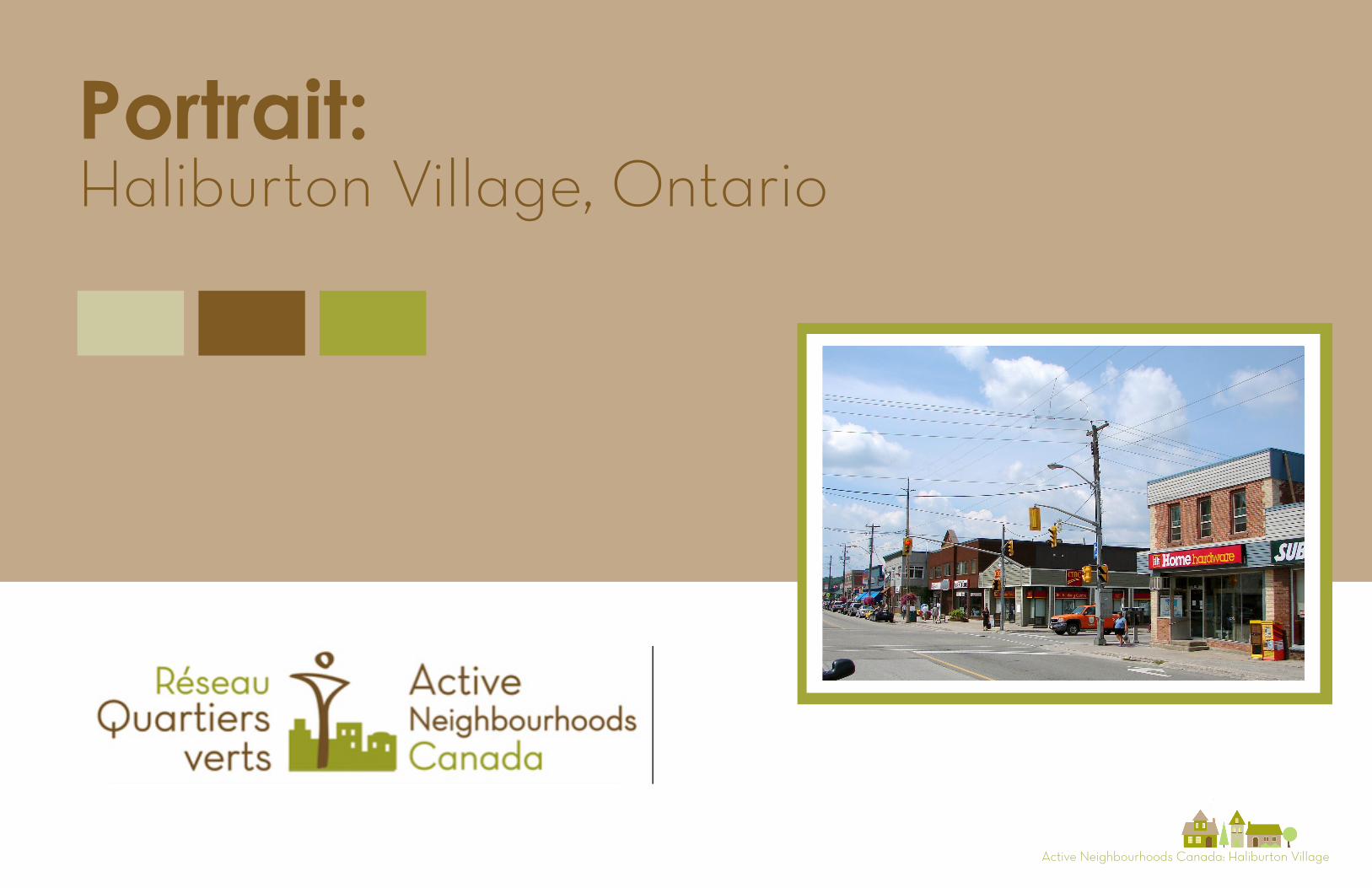
Portrait:Haliburton Village, Ontario
Active Neighbourhoods Canada: Haliburton Village
April 2016
This portrait was produced by the Toronto Centre for Active Transportation, a project of the Clean Air Partnership in Toronto, Ontario.
Authors:Car Martin, Project Manager & Design LeadMikey Bennington, Project Manager & Research LeadOverseen by Nancy Smith Lea, TCAT Director
Graphics and Research support:Tharmiha Kanagathasan, Planning InternGavin Liu, Planning Intern
Local Partners:Communities in Action CommitteeHaliburton County Community Cooperative
Active Neighbourhoods Canada: Haliburton Village
TABLE OF CONTENTS
Introduction
Social & Physical Characteristics
Movement Patterns
Local Experience
Case Studies: “through road, main street”
Summary of Key Challenges & Opportunities
4
8
14
17
20
24
Active Neighbourhoods Canada: Haliburton Village
Active Neighbourhoods Canada: Haliburton Village
National Project Introduction
Active Neighbourhoods Canada (ANC) is a national partnership of organizations bringing participatory planning to 12 communities in Alberta, Ontario and Quebec. ANC works with local partners in each community towards changes in the built environment that encourage active transportation, active public spaces and active, engaged citizens. This portrait illustrates the third Ontario community to join the ANC project: Haliburton Village in the County of Haliburton. It is a snapshot of the community compiled through focus groups, observations and secondary research.
The Active Neighbourhoods project employs lessons learned from the ‘Green Active and Healthy Neighbourhoods’ pilot created by the Montreal Urban Ecology Centre and further develops the methods to suit local contexts.
Each local project is divided into three phases. Documentation of phase 1 for Haliburton Village can be seen on the following pages.
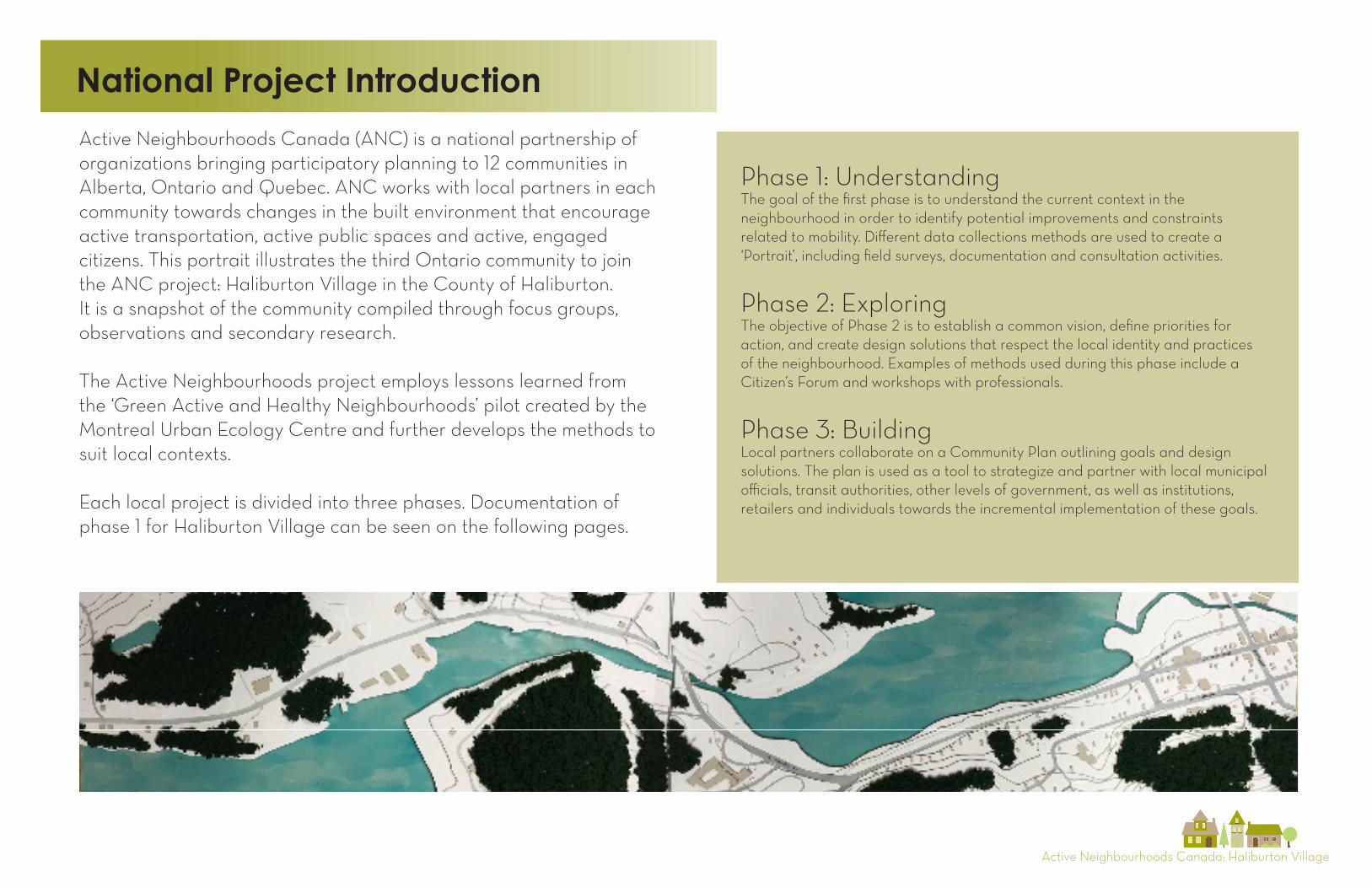
Phase 1: UnderstandingThe goal of the first phase is to understand the current context in the neighbourhood in order to identify potential improvements and constraints related to mobility. Different data collections methods are used to create a ‘Portrait’, including field surveys, documentation and consultation activities.
Phase 2: ExploringThe objective of Phase 2 is to establish a common vision, define priorities for action, and create design solutions that respect the local identity and practices of the neighbourhood. Examples of methods used during this phase include a Citizen’s Forum and workshops with professionals.
Phase 3: BuildingLocal partners collaborate on a Community Plan outlining goals and design solutions. The plan is used as a tool to strategize and partner with local municipal officials, transit authorities, other levels of government, as well as institutions, retailers and individuals towards the incremental implementation of these goals.
Active Neighbourhoods Canada: Haliburton Village
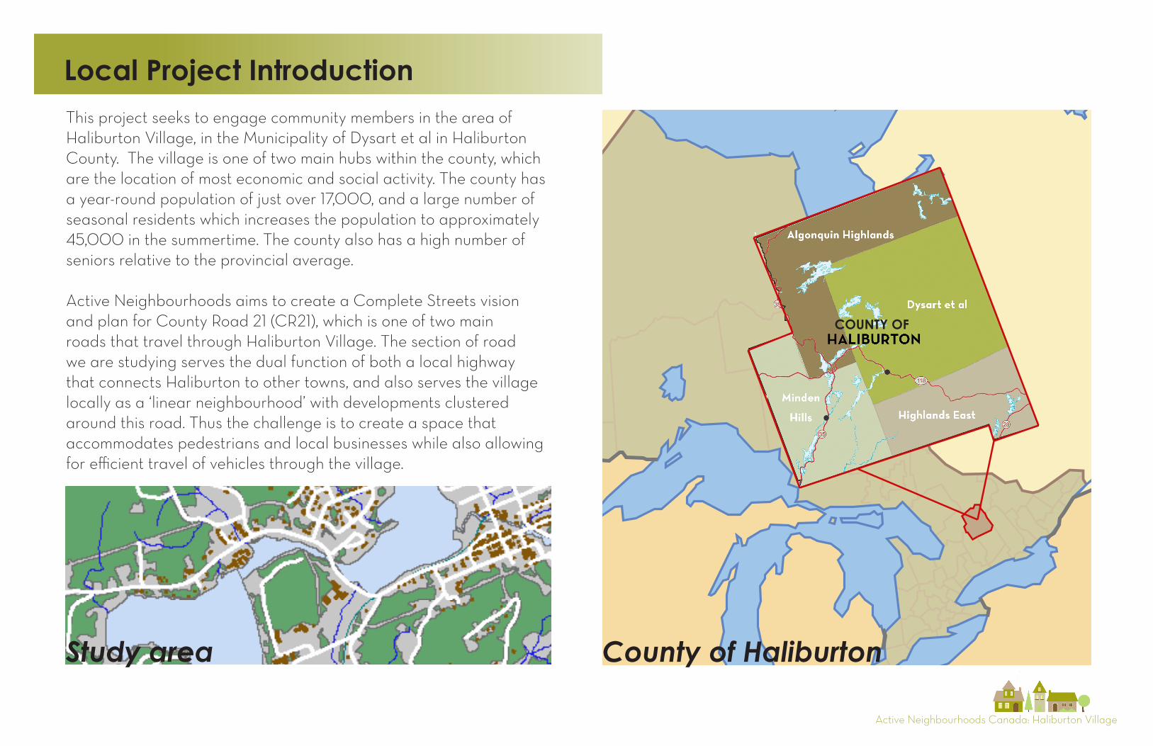
Local Project IntroductionThis project seeks to engage community members in the area of Haliburton Village, in the Municipality of Dysart et al in Haliburton County. The village is one of two main hubs within the county, which are the location of most economic and social activity. The county has a year-round population of just over 17,000, and a large number of seasonal residents which increases the population to approximately 45,000 in the summertime. The county also has a high number of seniors relative to the provincial average.
Active Neighbourhoods aims to create a Complete Streets vision and plan for County Road 21 (CR21), which is one of two main roads that travel through Haliburton Village. The section of road we are studying serves the dual function of both a local highway that connects Haliburton to other towns, and also serves the village locally as a ‘linear neighbourhood’ with developments clustered around this road. Thus the challenge is to create a space that accommodates pedestrians and local businesses while also allowing for efficient travel of vehicles through the village.
Study area County of Haliburton
COUNTY OF
Active Neighbourhoods Canada: Haliburton Village
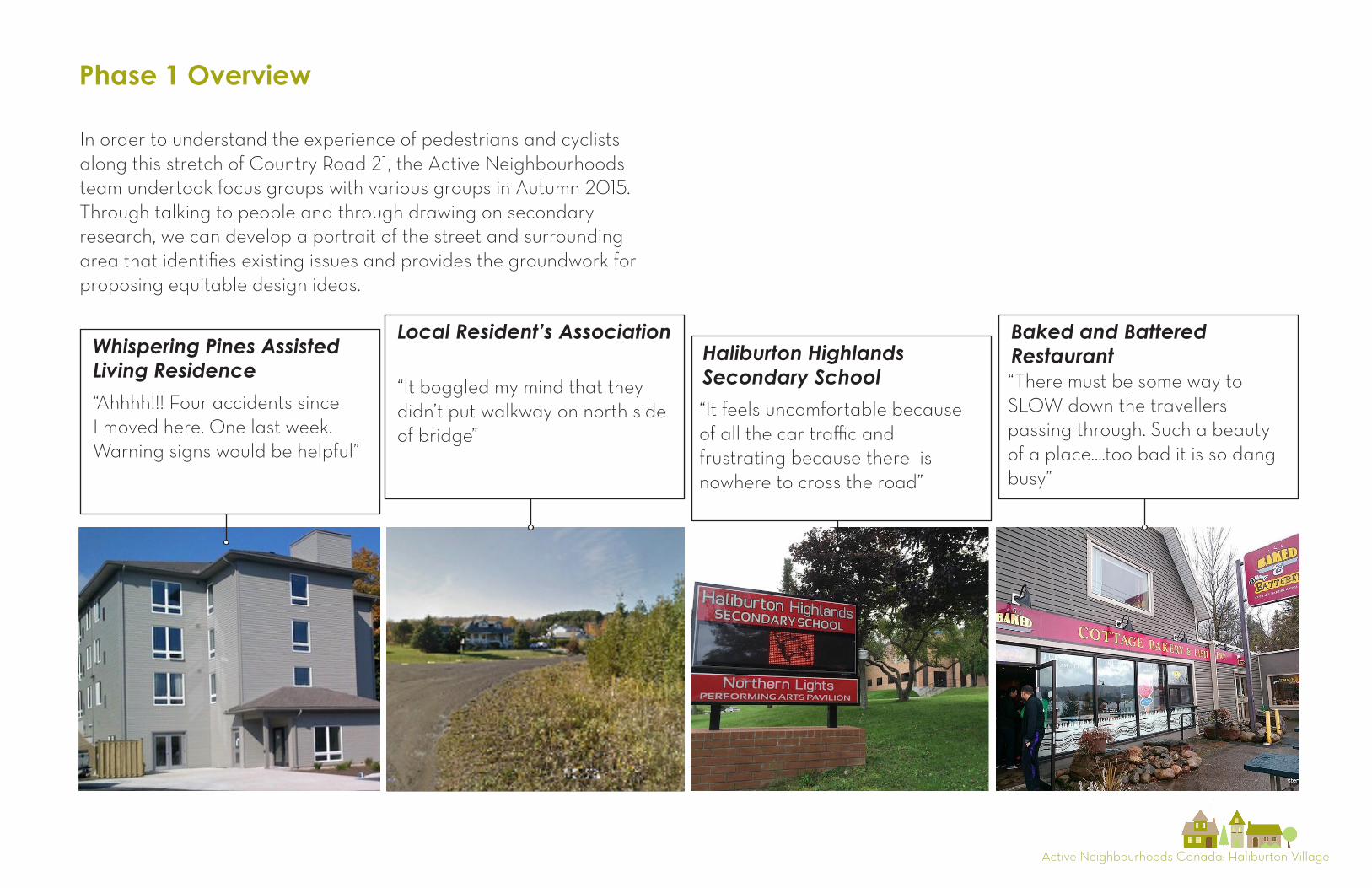
In order to understand the experience of pedestrians and cyclists along this stretch of Country Road 21, the Active Neighbourhoods team undertook focus groups with various groups in Autumn 2015. Through talking to people and through drawing on secondary research, we can develop a portrait of the street and surrounding area that identifies existing issues and provides the groundwork for proposing equitable design ideas.
Phase 1 Overview
Whispering Pines Assisted Living Residence
Local Resident’s AssociationHaliburton HighlandsSecondary School
Baked and BatteredRestaurant“There must be some way to SLOW down the travellers passing through. Such a beauty of a place....too bad it is so dang busy”
“It boggled my mind that they didn’t put walkway on north side of bridge”
“Ahhhh!!! Four accidents since I moved here. One last week. Warning signs would be helpful”
“It feels uncomfortable because of all the car traffic and frustrating because there is nowhere to cross the road”

Active Neighbourhoods Canada: Haliburton Village
Local Partner-Communities in Action (CIA)
2004 2005 2006 2007 2009 2012 2014 2015
Communities in Action (CIA) was formed
CIA initiates community-based research on the state of Active Transportation in Haliburton Village.
Research indicated four ‘negative hotspots’ for active transportation
Initiation of “Park the Car and Get Moving” campaign
Development of ‘Walk, Bike and Be Active” signs and maps
CIA contracted a consultant to develop Active Transportation Plan of Haliburton Village. Presented to council in June
Submission of recommended policies during the municipality’s 5-year Official Plan review.
Through the CIA, Haliburton Village participated in Green Communities Canada’s Walkability Roadshow
‘Seven Years Later’ evaluation strategy initiated. Started with community survey to measure AT behaviour and key informant interviews with municipal staff and councillors
‘Seven Years Later: Evaluating Impact on Active Transportation in Haliburton’ wascompleted
Implementation of ‘Share the Road’ campaign
Observational counts completed for the ‘Seven Years Later’ evaluation strategy
CIA works with students in Fleming College Geomatics program to develop an online map of the Head Lake Trail
Active Transportation Plan for Haliburton Village is updated
CIA will act as the lead local agency in supporting Active Neighbourhoods Canada (ANC) project in Haliburton Village, specifically centered on County Road 21
CIA begins working with landscape architects in devel-oping conceptual illustrations for the four ‘negative hot- spots to provide visual image of potential improve-ments
2011 2013
The Communities in Action (CIA) Committee was formed in 2004 to create healthy, active communities by promoting the benefits of active transportation, advocating for policies and investments that will lead to communities that are designed to support and encourage active transportation, doing research in order to develop an evidence-base for rural active transportation planning and implementation, and developing partnerships with
multiple sectors in order to build knowledge and capacity around active transportation. Since its formation in 2004 the CIA has undertaken numerous projects that have led to positive change in the direction of safer, more active streets in the Haliburton Village area and surroundings. The timeline below is a summary of active transportation initiatives in the area, most of which were lead by the CIA.
Active Neighbourhoods Canada: Haliburton Village
Social & Physical Characteristics
1 Tim Horton’s 2 Todd’s Independent Grocer3 Beer Store4 Haliburton Highlands Family Health Team5 Haliburton Hospital
6 Haliburton Highland Secondary School7 Head Lake Park8 Head Lake Trail 9 Shoppers Drug Mart 10 Emmerson Lumber Ltd.
Destinations Map
2
11 Haliburton Library12 Foodland13 Rexall14 LCBO15 Royal Canadian Legion Branch 12916 Haliburton Curling Club
5
4
12
13
8
109
7
14
3
6
11
1
3
4
5
6
7
8
910
1314
1516
Grass Lake
Head Lake
2
11
12Key Nodes 1 Tim Horton’s2 Todd’s Independent Grocer3 Beer Store4 Haliburton Highlands Health Centre 5 Haliburton Hospital6 Haliburton Highlands Secondary School7 Head Lake Park8 Head Lake Trail9 Shoppers Drug Mart10 Emmerson Lumber Ltd.11 Haliburton Library12 Foodland13 Rexall14 LCBO15 Royal Canadian Legion Branch 12916 A.J. LaRue Arena
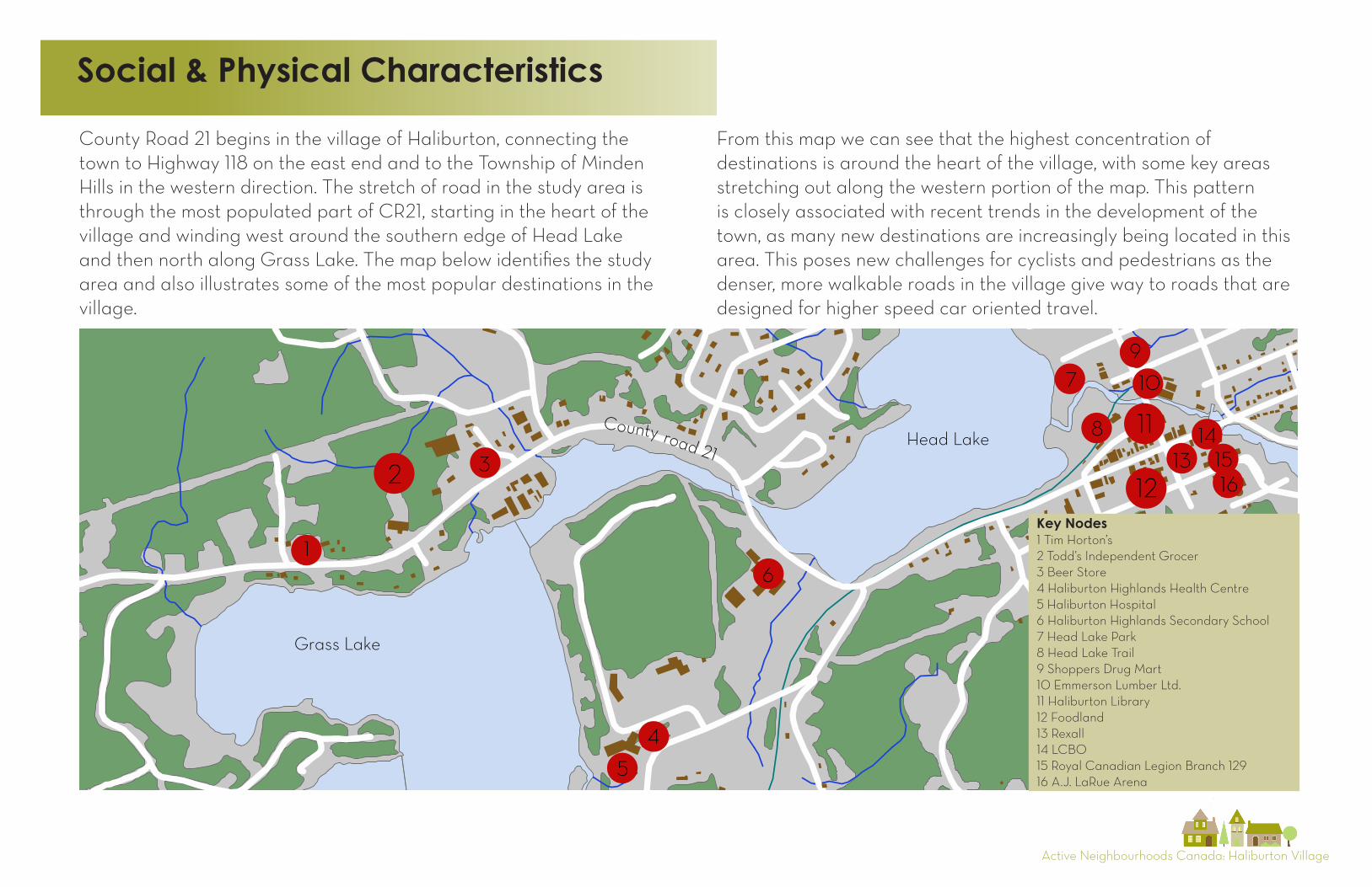
County Road 21 begins in the village of Haliburton, connecting the town to Highway 118 on the east end and to the Township of Minden Hills in the western direction. The stretch of road in the study area is through the most populated part of CR21, starting in the heart of the village and winding west around the southern edge of Head Lake and then north along Grass Lake. The map below identifies the study area and also illustrates some of the most popular destinations in the village.
From this map we can see that the highest concentration of destinations is around the heart of the village, with some key areas stretching out along the western portion of the map. This pattern is closely associated with recent trends in the development of the town, as many new destinations are increasingly being located in this area. This poses new challenges for cyclists and pedestrians as the denser, more walkable roads in the village give way to roads that are designed for higher speed car oriented travel.
Active Neighbourhoods Canada: Haliburton Village
Local road network
Street Hierarchy
County Road 21
Local Road
Built Form
To Fleming College & Glebe Park
Public schools
Hospital/healthcentre
High school
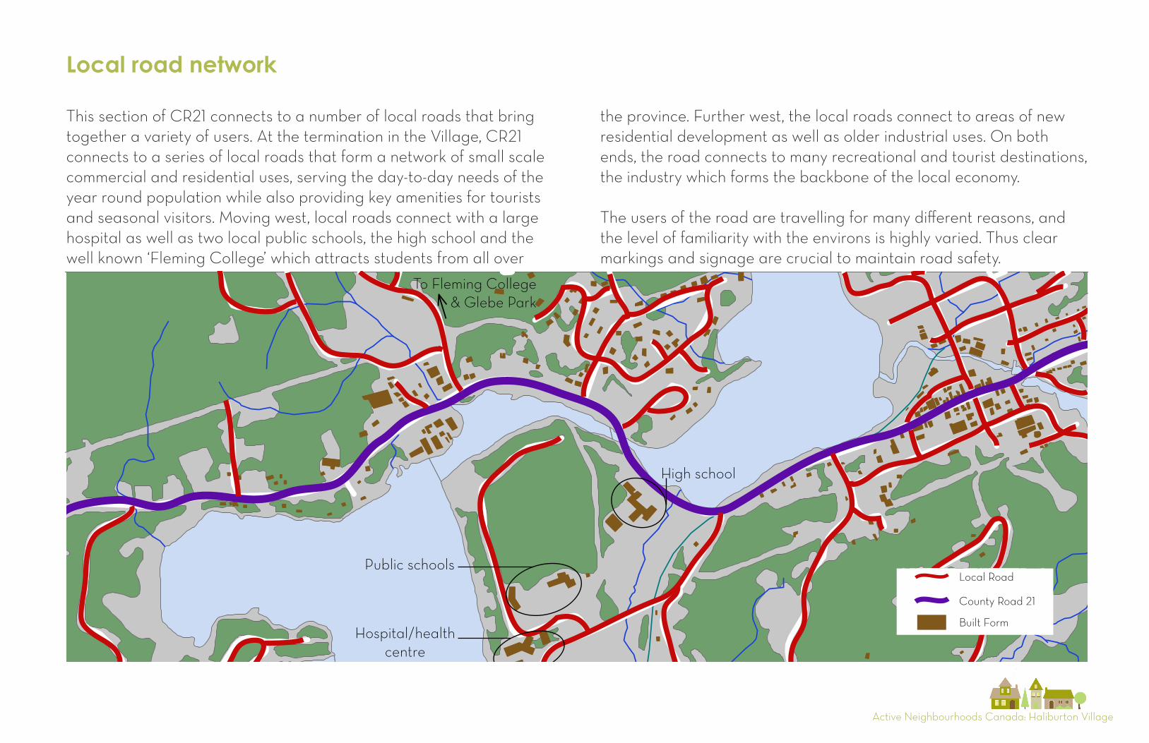
This section of CR21 connects to a number of local roads that bring together a variety of users. At the termination in the Village, CR21 connects to a series of local roads that form a network of small scale commercial and residential uses, serving the day-to-day needs of the year round population while also providing key amenities for tourists and seasonal visitors. Moving west, local roads connect with a large hospital as well as two local public schools, the high school and the well known ‘Fleming College’ which attracts students from all over
Street Hierarchy
County Road 21
Local Road
Built Form
To Fleming College & Glebe Park
Public schools
Hospital/healthcentre
High school
the province. Further west, the local roads connect to areas of new residential development as well as older industrial uses. On both ends, the road connects to many recreational and tourist destinations, the industry which forms the backbone of the local economy.
The users of the road are travelling for many different reasons, and the level of familiarity with the environs is highly varied. Thus clear markings and signage are crucial to maintain road safety.
Active Neighbourhoods Canada: Haliburton Village
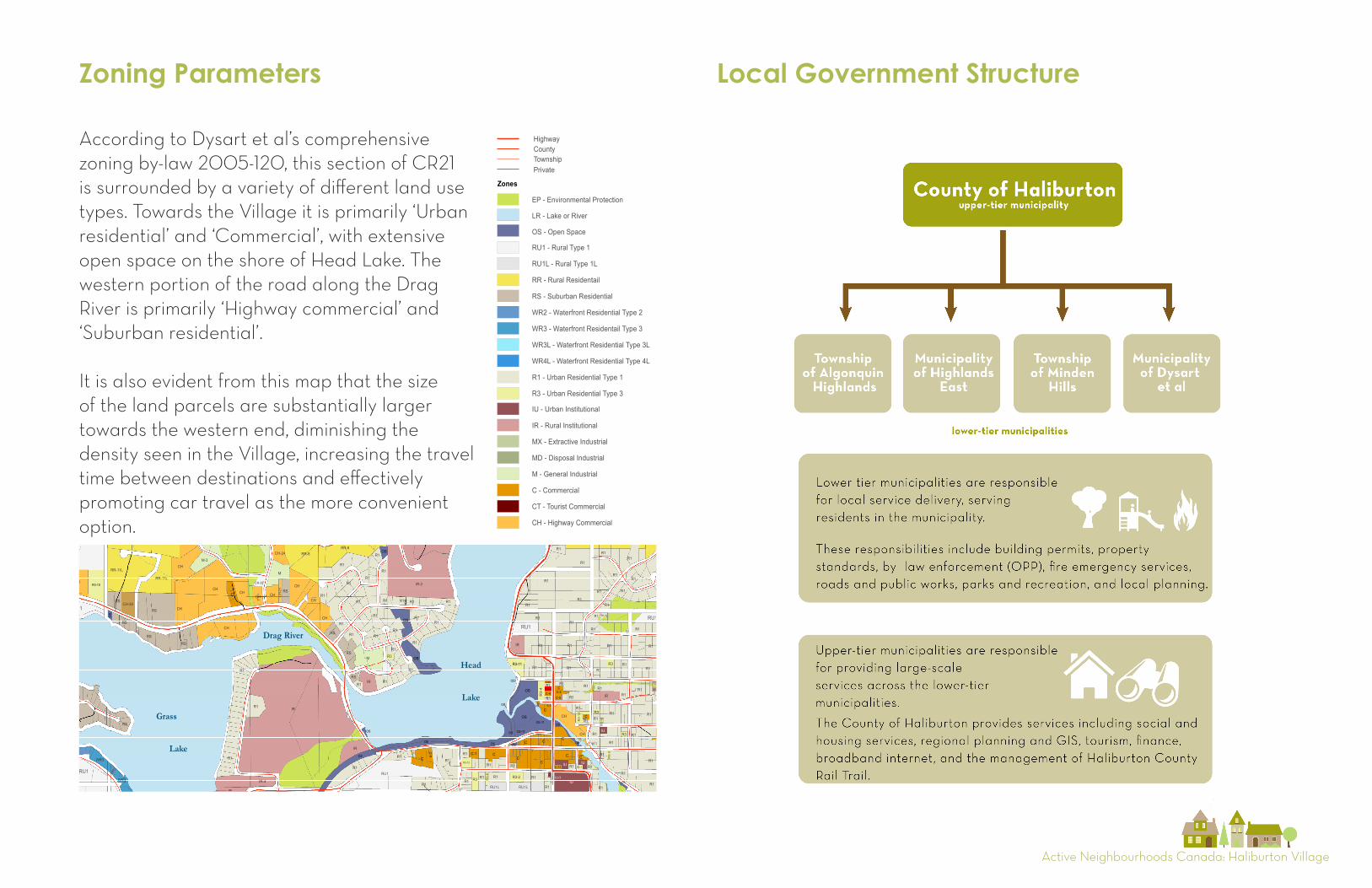
Zoning Parameters
According to Dysart et al’s comprehensive zoning by-law 2005-120, this section of CR21 is surrounded by a variety of different land use types. Towards the Village it is primarily ‘Urban residential’ and ‘Commercial’, with extensive open space on the shore of Head Lake. The western portion of the road along the Drag River is primarily ‘Highway commercial’ and ‘Suburban residential’.
It is also evident from this map that the size of the land parcels are substantially larger towards the western end, diminishing the density seen in the Village, increasing the travel time between destinations and effectively promoting car travel as the more convenient option.
Local Government Structure
R3-10
RU1
RU1
RU1
RU1
RU1
RU1
RU1
RU1
RU1
OS
RU1
RU1
RU1
RU1
RU1
RU1
RU1
RU1
RR-12
RU1
RU1
RU1
RU1
RU1
RU1
RU1
RU1
RU1
RU1
RU1
RU1
RU1
RU1
RU1
RU1
RU1
RU1
RU1
RU1
RU1
RU1
RU1
RU1
RU1
RU1
RU1
RU1
RU1
RU1
RU1
RU1
RU1
RU1
RU1
RU1
RU1
RU1
RU1
RU1
RU1
RU1
RU1
RU1
RU1
RU1
RU1
RU1
RU1
RU1
RU1
RU1
RU1
RU1RU1
RU1
RU1
RU1
RU1
RU1
RU
1
CH-28
R1
RU1-1
RU1L
RU1L
RU
1L
RU1L
RU1L
RU1L
RU1L
RU1L
RU1L RU1L
RU1L
RU1LRU1L
RU1L
RU1L
RR
RR RR
RR
RR
RR
RR
RR
RR
RR
RR
RR
RR
RR
RR
RR-1
RR-1
RR-1 RR-1
RR
-1
RR-3RR-3
RR-3
RR-3
RR-5
RR-7 RR-7
RR-8
RR-8
RR-8
RR-8
RR-8
RR-11L
RR-11L
RR-11L
RS
RS
RS
RS
RSRS
RS
RS
RS
WR2
WR2
RS
WR2
RS
RS
WR
2
WR3
WR3
WR3
WR3
WR3L
WR4L
R1
R1
R1
R1
R1
R1
R1
R1
R1
R1
R1
R1
R1
R1
R1
R1
R1
R1
R1
R1
R1
R1
R1
R1
R1
R1
R1 R1
R1
R1
R1
R1
R1
R1
R1
R1
R1
R1
R1
R1
R1
R1
R1
R1
R1
R1
R1
R1
R1
R1
R1
R1
R1
R1
R1 R1
R1
R1
R1
R1
R1
R1
R1
R1
R1
R1
R1
R1
R1
R1
R1
R1
R1
R1
R1
R1
R1
R1
R1
R1
R3
R1
R1
R3-12
R1
R1
R1
R1
R1
R1
R1
R1
R1
R1
R1
R1
R1
R1
R1
R1
R1
R1
R1
R3
R1
R1R1
R1
R1
R1
R1
R1R1
R1
R1
R1
R1
R1
R1
R1
R1
R1
R1
R1
R1
R1
R1
R1
R1
R1
R1
R1
R1
R1
R1
R1
R1
R1
R3-
9
R1
R1R1
R1
R1
R1
R1
R1
R1
R1
R1
R1-1
R1-
2
R1-3L
R3
R3
R3
R3
R3-1
R3-2
R3-2
R3-2
R3-
3
R3-
4
R3-5
R3-
6
CH-30
R1
R1-4
R3-7
CH-29
IR-5
R1
R3-
13
OS
OS
OS
OS
OS
OS
OS
OS
OS
OS
OS
OS
OS
OS
OS
OS
OS
OS OS
OS
OS
OS
OSOS
OS
OS-11
R1
R1-5
OS-11
IU
IU
IU
IU
IU
IU-2
IU-3
IR
IR
IR
IRIR
IR
IR
IR
IR-2
IR-2
IR-3
IR-4
MX
MD
M
M
M
M
M
M
M
M
M
M
M
MM
M-2
M-3
M-6
CC
C
C
C
CCC
C
C
C
C
C
C
C
C-1
C-2
C-3
H-C-4
R3-11
C-4C-5
C-6
C-9
CH-10
C-11
CT
CH
CH
CH
CH
CH
CH
CH
CH
CH
CH
CH
CH
CHCH
CH
CH
CH
CH CH
-21
CH-24
Municipality of Dysart et alHALIBURTON VILLAGE AREA
Dysart Township
SCHEDULE "A" MAP 1
µ
0 250 500 750 1,000125Meters
SCALE
REVISED: August, 2011
DISCLAIMER: This map is for planning reference purposes only and is not a survey of properties. No representation is made or warranty given as to its content. User assumesall risk of use. The Municipality of Dysart et al assumes no responsibility for anyloss resulting from such use. This publication may not be reproduced in any form,in part or in whole, without written permission.
BASE DATA SOURCE: QUEEN'S PRINTER OF ONTARIOUse of this data does not constituete an endorsment by MNR or the Ontario Government.
Algonquin
Provincial
Park
HALIBURTON
DysartDudley Harcourt
Guilford Harburn
Havelock Eyre
LEGENDRoad Jurisdiction
CountyHighway
PrivateTownship
LR - Lake or River
RU1 - Rural Type 1
RU1L - Rural Type 1L
RR - Rural Residentail
RS - Suburban Residential
WR2 - Waterfront Residential Type 2
WR3 - Waterfront Residentail Type 3
WR3L - Waterfront Residential Type 3L
WR4L - Waterfront Residential Type 4L
R1 - Urban Residential Type 1
R3 - Urban Residential Type 3
OS - Open Space
IU - Urban Institutional
IR - Rural Institutional
MX - Extractive Industrial
MD - Disposal Industrial
M - General Industrial
C - Commercial
CT - Tourist Commercial
CH - Highway Commercial
EP - Environmental Protection
Zones
CON VIII
CON VII
CON IX
LOT 11 LOT 13 LOT 15 LOT 17 LOT 19 LOT 21
Head
Lake
Grass
Lake
Barnum
Lake
Moss's
Pond
Drag River
Active Neighbourhoods Canada: Haliburton Village
Transportation and Health
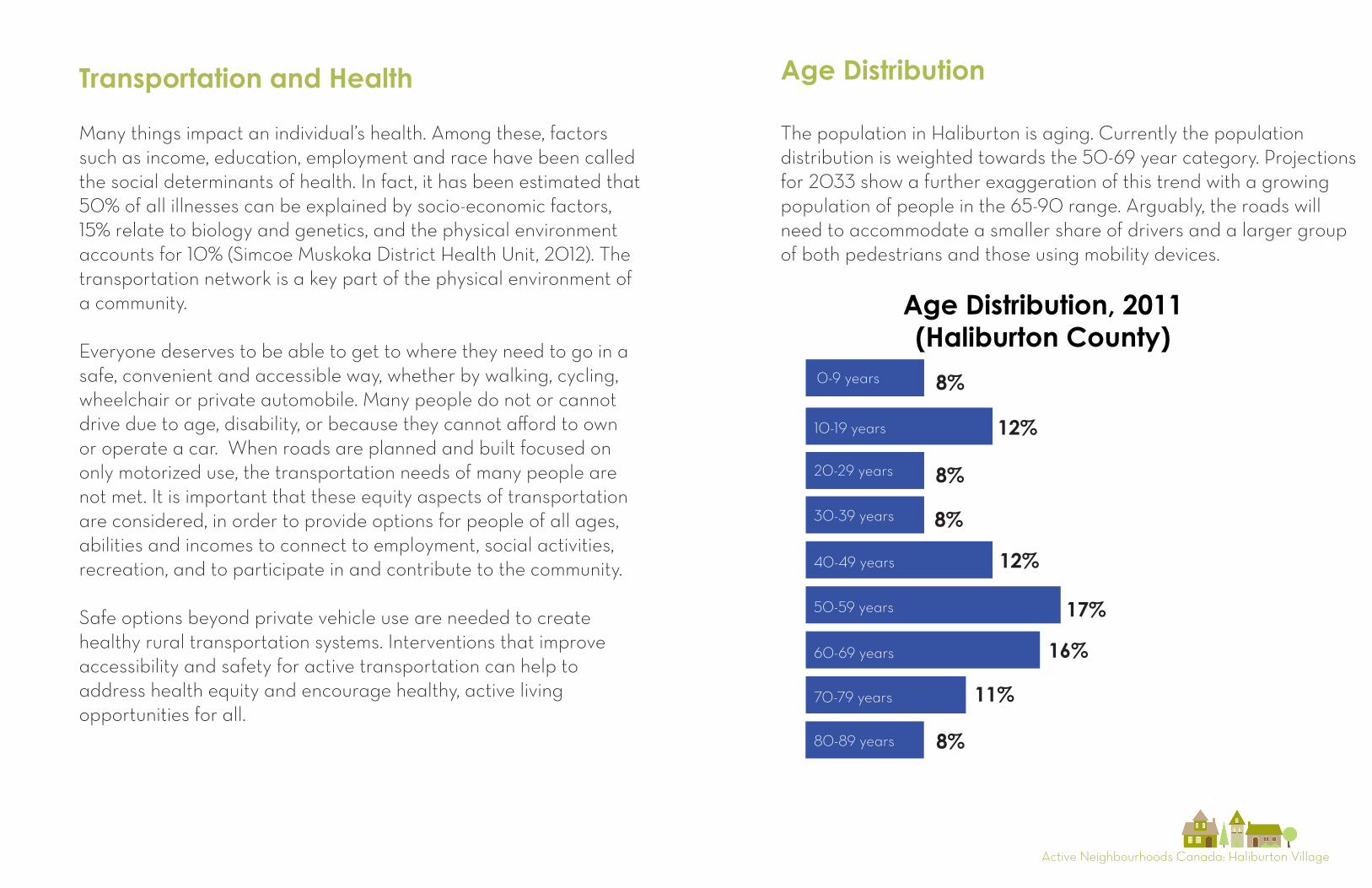
The population in Haliburton is aging. Currently the population distribution is weighted towards the 50-69 year category. Projections for 2033 show a further exaggeration of this trend with a growing population of people in the 65-90 range. Arguably, the roads will need to accommodate a smaller share of drivers and a larger group of both pedestrians and those using mobility devices.
8%
12%
8%
8%
12%
17%
16%
11%
8%
Age Distribution, 2011 (Haliburton County)
0-9 years
10-19 years
20-29 years
30-39 years
40-49 years
50-59 years
60-69 years
70-79 years
80-89 years
Age Distribution
Many things impact an individual’s health. Among these, factors such as income, education, employment and race have been called the social determinants of health. In fact, it has been estimated that 50% of all illnesses can be explained by socio-economic factors, 15% relate to biology and genetics, and the physical environment accounts for 10% (Simcoe Muskoka District Health Unit, 2012). The transportation network is a key part of the physical environment of a community.
Everyone deserves to be able to get to where they need to go in a safe, convenient and accessible way, whether by walking, cycling, wheelchair or private automobile. Many people do not or cannot drive due to age, disability, or because they cannot afford to own or operate a car. When roads are planned and built focused on only motorized use, the transportation needs of many people are not met. It is important that these equity aspects of transportation are considered, in order to provide options for people of all ages, abilities and incomes to connect to employment, social activities, recreation, and to participate in and contribute to the community.
Safe options beyond private vehicle use are needed to create healthy rural transportation systems. Interventions that improve accessibility and safety for active transportation can help to address health equity and encourage healthy, active living opportunities for all.
Active Neighbourhoods Canada: Haliburton Village
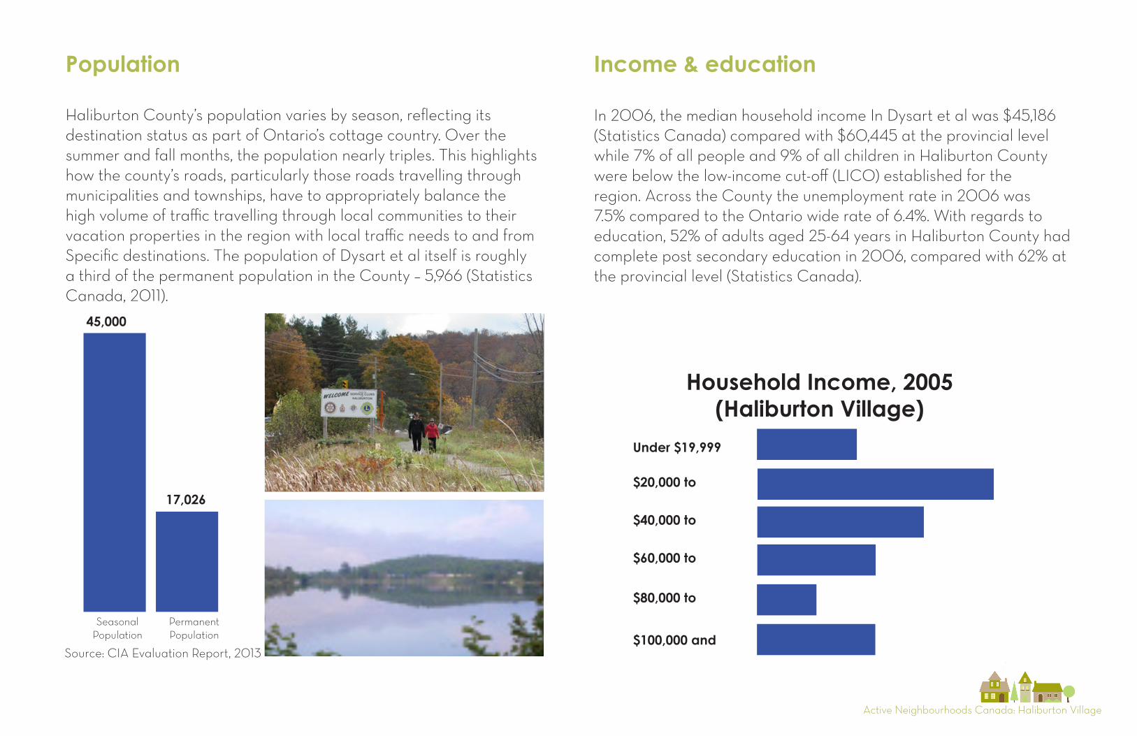
Population Income & education
Under $19,999
$20,000 to
$40,000 to
$60,000 to
$80,000 to
$100,000 and
Household Income, 2005 (Haliburton Village)
Seasonal Population
PermanentPopulation
45,000
17,026
In 2006, the median household income In Dysart et al was $45,186 (Statistics Canada) compared with $60,445 at the provincial level while 7% of all people and 9% of all children in Haliburton County were below the low-income cut-off (LICO) established for the region. Across the County the unemployment rate in 2006 was 7.5% compared to the Ontario wide rate of 6.4%. With regards to education, 52% of adults aged 25-64 years in Haliburton County had complete post secondary education in 2006, compared with 62% at the provincial level (Statistics Canada).
Haliburton County’s population varies by season, reflecting its destination status as part of Ontario’s cottage country. Over the summer and fall months, the population nearly triples. This highlights how the county’s roads, particularly those roads travelling through municipalities and townships, have to appropriately balance the high volume of traffic travelling through local communities to their vacation properties in the region with local traffic needs to and from Specific destinations. The population of Dysart et al itself is roughly a third of the permanent population in the County – 5,966 (Statistics Canada, 2011).
Source: CIA Evaluation Report, 2013
Active Neighbourhoods Canada: Haliburton Village4
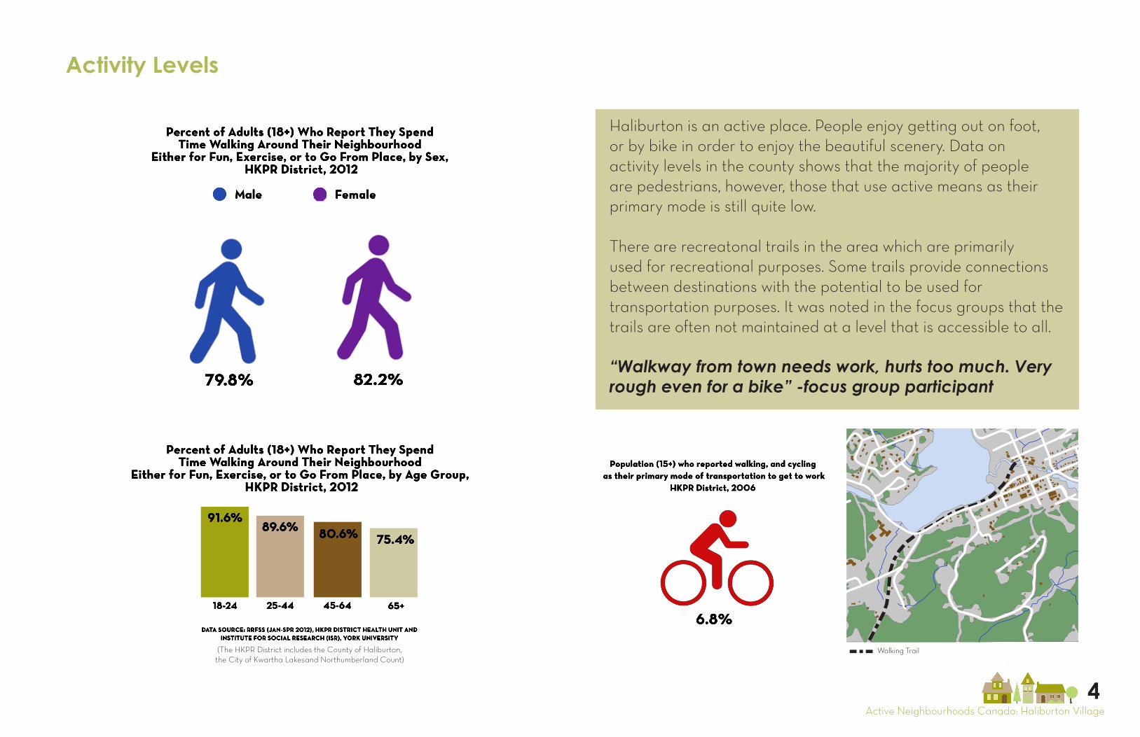
Activity Levels
Percent of Adults (18+) Who Report They Spend Time Walking Around Their Neighbourhood
Either for Fun, Exercise, or to Go From Place, by Sex, HKPR District, 2012
Male Female
Percent of Adults (18+) Who Report They Spend Time Walking Around Their Neighbourhood
Either for Fun, Exercise, or to Go From Place, by Age Group, HKPR District, 2012
79.8%
DATA SOURCE: RRFSS (JAN-SPR 2012), HKPR DISTRICT HEALTH UNIT AND INSTITUTE FOR SOCIAL RESEARCH (ISR), YORK UNIVERSITY
18-24 25-44 45-64 65+
82.2%
91.6%89.6% 80.6% 75.4%
6.8%
Population (15+) who reported walking, and cycling as their primary mode of transportation to get to work
HKPR District, 2006
Walking Trail
Haliburton is an active place. People enjoy getting out on foot, or by bike in order to enjoy the beautiful scenery. Data on activity levels in the county shows that the majority of people are pedestrians, however, those that use active means as their primary mode is still quite low.
There are recreatonal trails in the area which are primarily used for recreational purposes. Some trails provide connections between destinations with the potential to be used for transportation purposes. It was noted in the focus groups that the trails are often not maintained at a level that is accessible to all.
“Walkway from town needs work, hurts too much. Very rough even for a bike” -focus group participant
(The HKPR District includes the County of Haliburton, the City of Kwartha Lakesand Northumberland Count)
Active Neighbourhoods Canada: Haliburton Village
Movement Patterns
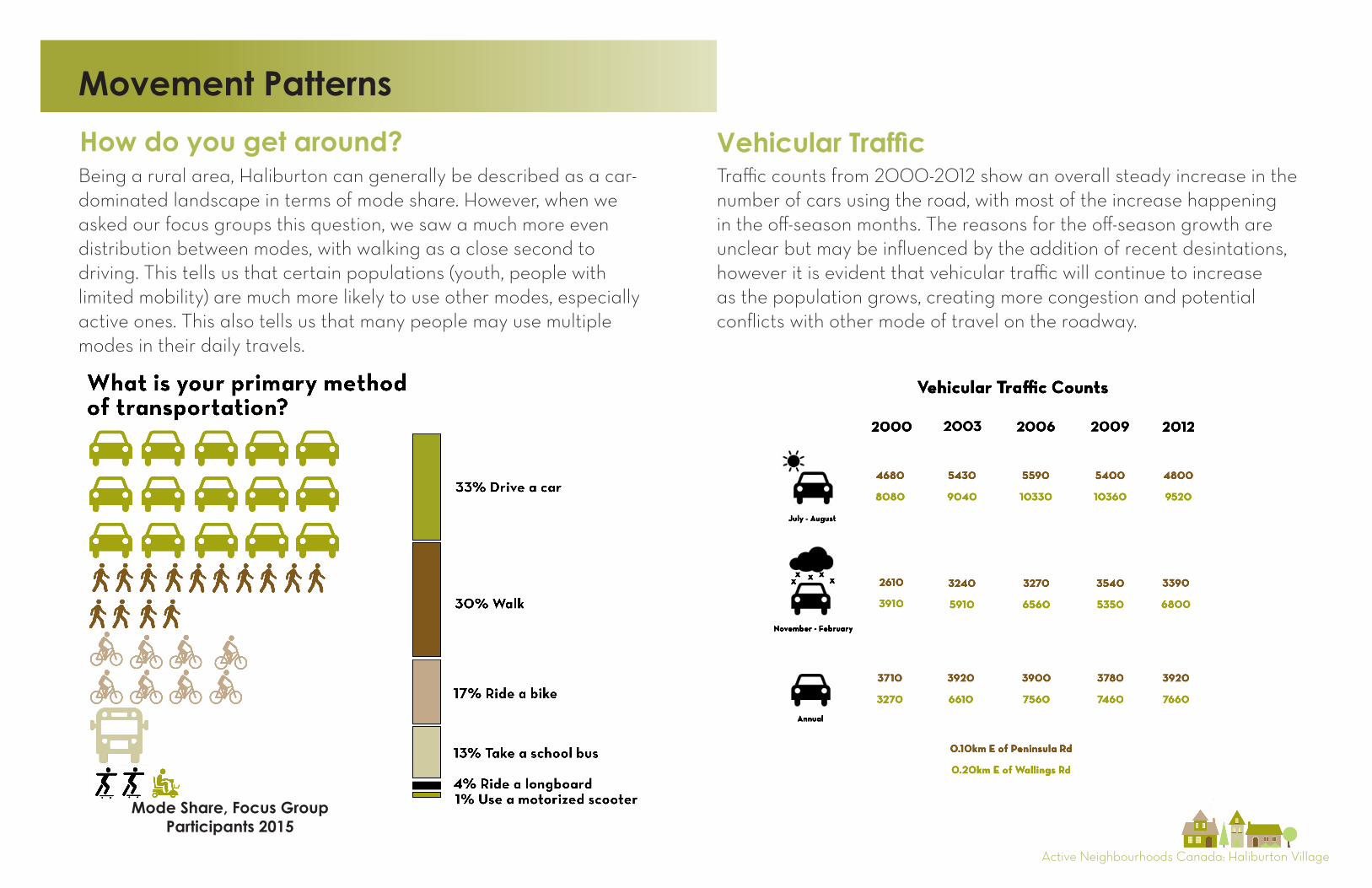
How do you get around?Being a rural area, Haliburton can generally be described as a car-dominated landscape in terms of mode share. However, when we asked our focus groups this question, we saw a much more even distribution between modes, with walking as a close second to driving. This tells us that certain populations (youth, people with limited mobility) are much more likely to use other modes, especially active ones. This also tells us that many people may use multiple modes in their daily travels.
Mode Share, Focus GroupParticipants 2015
xxxxx
2000 2003 2006 2009 2012
3710
3270
3920
6610
3900
7560
3780
7460
3920
7660
0.10km E of Peninsula Rd
0.20km E of Wallings Rd
Vehicular Traffic Counts
Annual
July - August
November - February
2610
3910
3240
5910
3270
6560
3540
5350
3390
6800
4680
8080
5430
9040
5590
10330
5400
10360
4800
9520
Vehicular TrafficTraffic counts from 2000-2012 show an overall steady increase in the number of cars using the road, with most of the increase happening in the off-season months. The reasons for the off-season growth are unclear but may be influenced by the addition of recent desintations, however it is evident that vehicular traffic will continue to increase as the population grows, creating more congestion and potential conflicts with other mode of travel on the roadway.
Active Neighbourhoods Canada: Haliburton Village
Better infrastructure maintenance
More paved shoulders
Better sidewalks/trails
Strongest factors that would encourage people to use active
transportation more often
Active Transportation
Students in Dysart et al have access to school bus services even at walkable distances from their school largely due tosafety issues with students walking to school along routes like CR21 and a school policy on bussing. This demonstrates the how safety is of prime concern for those using these routes, especially students.
Additionally, those living in Dysart et al with impaired mobility would benefit greatly from a reliable and available bus service in the township. Without this kind of service the independence of these residents is significantly limited.
Bus services
Improvements to the streetscape in Haliburton Village appear to have contributed to significant increases in the amount of people using active transportation between 2005 and 2012. particularly at Highland St. and Maple Ave. Over the same time, the number of people using AT along CR21 has dropped. Below are active transportation counts conducted by CIA at key points in Haliburton.
“I believe in independence; if there was a bus, you better believe I’d use it.”
“I would like to see a more frequent bus. The problem with DYMO is I have to set up a ride 2-3 days in
advance and it can’t always come.”
“HHHS van came out but nothing really came of that; the days he was available didn’t coincide with when
the foodbank is open.”
-focus group participants
For more information on Active Transportation in Haliburton check out
“Seven Years Later” a report by CIA at:
www.communitiesinaction.ca
Active Neighbourhoods Canada: Haliburton Village
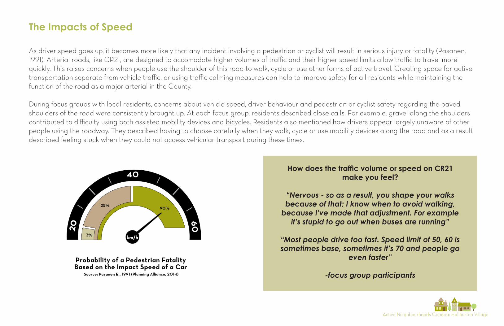
The Impacts of Speed
As driver speed goes up, it becomes more likely that any incident involving a pedestrian or cyclist will result in serious injury or fatality (Pasanen, 1991). Arterial roads, like CR21, are designed to accomodate higher volumes of traffic and their higher speed limits allow traffic to travel more quickly. This raises concerns when people use the shoulder of this road to walk, cycle or use other forms of active travel. Creating space for active transportation separate from vehicle traffic, or using traffic calming measures can help to improve safety for all residents while maintaining the function of the road as a major arterial in the County.
During focus groups with local residents, concerns about vehicle speed, driver behaviour and pedestrian or cyclist safety regarding the paved shoulders of the road were consistently brought up. At each focus group, residents described close calls. For example, gravel along the shoulders contributed to difficulty using both assisted mobility devices and bicycles. Residents also mentioned how drivers appear largely unaware of other people using the roadway. They described having to choose carefully when they walk, cycle or use mobility devices along the road and as a result described feeling stuck when they could not access vehicular transport during these times.
How does the traffic volume or speed on CR21 make you feel?
“Nervous - so as a result, you shape your walks because of that; I know when to avoid walking,
because I’ve made that adjustment. For example it’s stupid to go out when buses are running”
“Most people drive too fast. Speed limit of 50, 60 is sometimes base, sometimes it’s 70 and people go
even faster”
-focus group participants
Active Neighbourhoods Canada: Haliburton Village
Local experience
6
7
8
9
2
3
4
5
1 Tim Horton’s 2 Peninsula Drive 3 County Rose Garden Centre 4 Head Lake Grill 5 Head Lake Bike Lane
1
6
1 Tim Horton’s2 Todd’s Independent Grocer3 Bridge Crossing4 Victoria Rail Trail5 Lakeshore6 Foodland
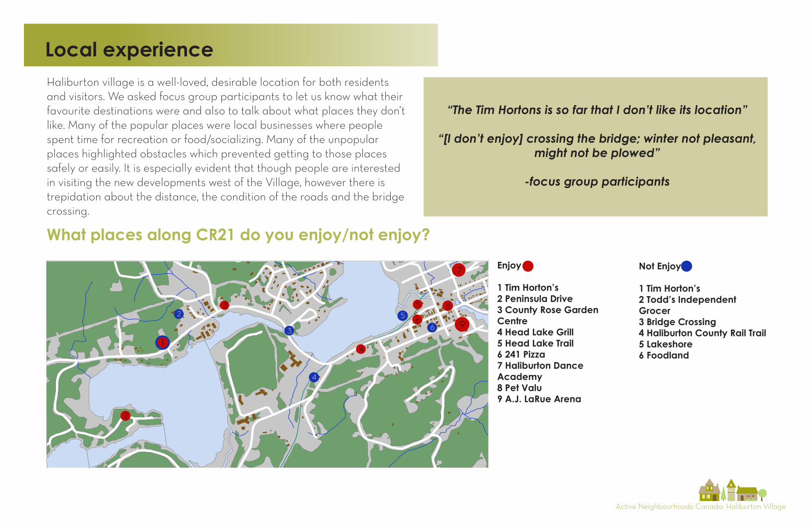
What places along CR21 do you enjoy (or not enjoy)?
Enjoy Not Enjoy
Size of circle represents number of votes
6 241 Pizza7 Haliburton Dance Academy8 Pet Valu9 A.J. LaRue Arena
4
3
52
Enjoy
1 Tim Horton’s2 Peninsula Drive3 County Rose Garden Centre4 Head Lake Grill5 Head Lake Trail6 241 Pizza7 Haliburton Dance Academy8 Pet Valu9 A.J. LaRue Arena
Not Enjoy
1 Tim Horton’s2 Todd’s Independent Grocer3 Bridge Crossing4 Haliburton County Rail Trail5 Lakeshore6 Foodland
What places along CR21 do you enjoy/not enjoy?
Haliburton village is a well-loved, desirable location for both residents and visitors. We asked focus group participants to let us know what their favourite destinations were and also to talk about what places they don’t like. Many of the popular places were local businesses where people spent time for recreation or food/socializing. Many of the unpopular places highlighted obstacles which prevented getting to those places safely or easily. It is especially evident that though people are interested in visiting the new developments west of the Village, however there is trepidation about the distance, the condition of the roads and the bridge crossing.
“The Tim Hortons is so far that I don’t like its location”
“[I don’t enjoy] crossing the bridge; winter not pleasant, might not be plowed”
-focus group participants
Active Neighbourhoods Canada: Haliburton Village
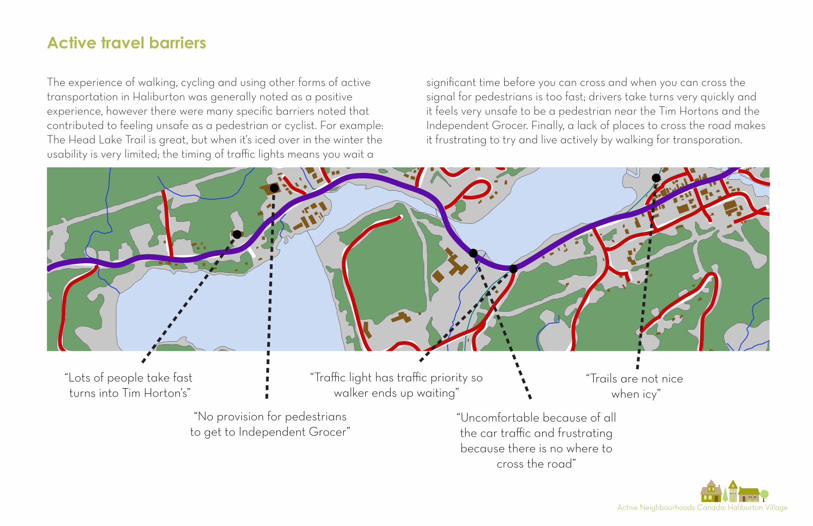
Active travel barriers
County Road 21
Local Road
What does it feel like to travel on CR21 when you are not driving?
“Lots of people take fast turns into Tim Horton’s”
“No provision for pedestrians to get to Independent Grocer”
“Uncomfortable because of all the car traffic and frustrating because there is no where to
cross the road”
“Trails are not nice when icy”
“Traffic light has traffic priority so walker ends up waiting”
The experience of walking, cycling and using other forms of active transportation in Haliburton was generally noted as a positive experience, however there were many specific barriers noted that contributed to feeling unsafe as a pedestrian or cyclist. For example:The Head Lake Trail is great, but when it’s iced over in the winter the usability is very limited; the timing of traffic lights means you wait a
significant time before you can cross and when you can cross the signal for pedestrians is too fast; drivers take turns very quickly and it feels very unsafe to be a pedestrian near the Tim Hortons and the Independent Grocer. Finally, a lack of places to cross the road makes it frustrating to try and live actively by walking for transporation.
Active Neighbourhoods Canada: Haliburton Village
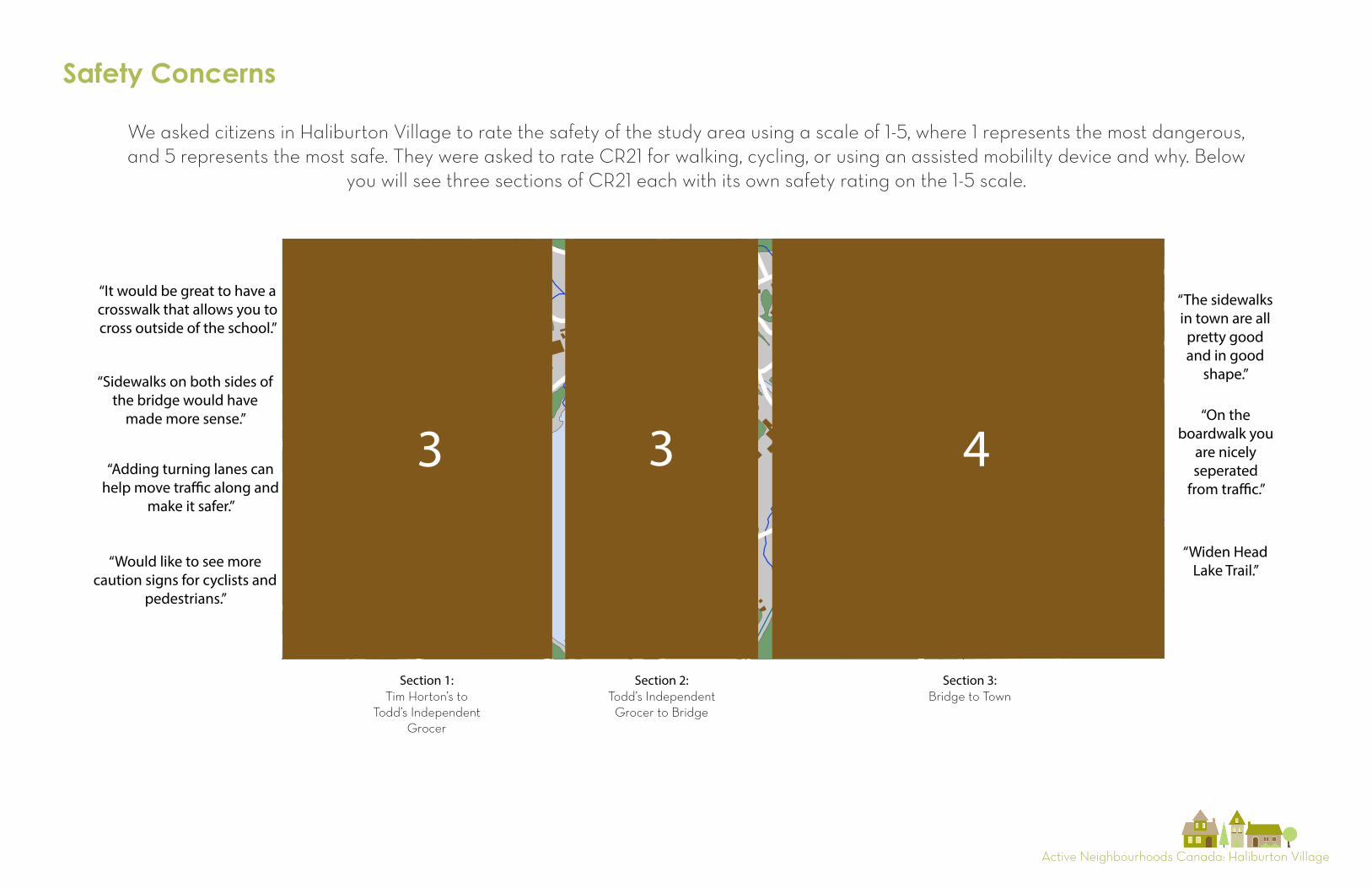
Section 1:Tim Horton’s to
Todd’s IndependentGrocer
Section 2:Todd’s Independent
Grocer to Bridge
Section 3:Bridge to Town
3 3 4
“The sidewalks in town are all
pretty good and in good
shape.”
“On the boardwalk you
are nicely seperated
from tra�c.”
“Widen Head Lake Trail.”
“It would be great to have a crosswalk that allows you to cross outside of the school.”
“Sidewalks on both sides of the bridge would have
made more sense.”
“Adding turning lanes can help move tra�c along and
make it safer.”
“Would like to see more caution signs for cyclists and
pedestrians.”
If you were to rate safety on a scale from 1-5 (1 being the most dangerous and 5 being the most safe), how would you rate CR21 for walking, cycling or using an assisted mobility device?
Safety Concerns
We asked citizens in Haliburton Village to rate the safety of the study area using a scale of 1-5, where 1 represents the most dangerous, and 5 represents the most safe. They were asked to rate CR21 for walking, cycling, or using an assisted mobililty device and why. Below
you will see three sections of CR21 each with its own safety rating on the 1-5 scale.
Active Neighbourhoods Canada: Haliburton Village
4
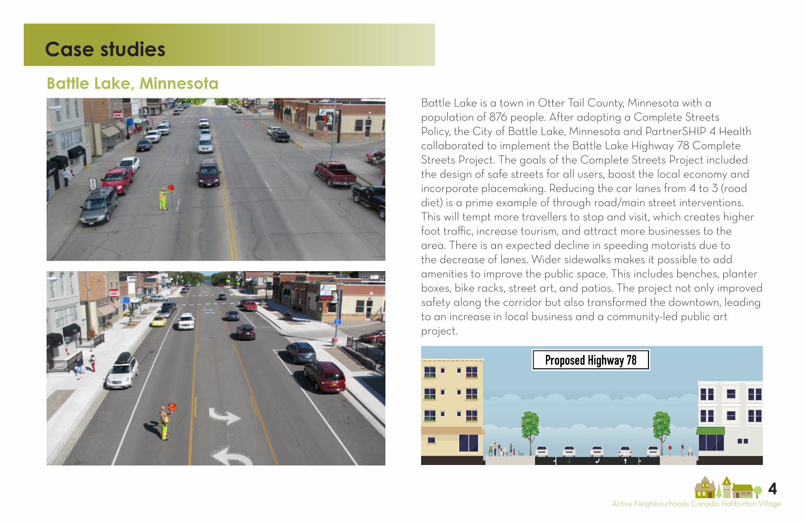
Battle Lake is a town in Otter Tail County, Minnesota with a population of 876 people. After adopting a Complete Streets Policy, the City of Battle Lake, Minnesota and PartnerSHIP 4 Health collaborated to implement the Battle Lake Highway 78 Complete Streets Project. The goals of the Complete Streets Project included the design of safe streets for all users, boost the local economy and incorporate placemaking. Reducing the car lanes from 4 to 3 (road diet) is a prime example of through road/main street interventions. This will tempt more travellers to stop and visit, which creates higher foot traffic, increase tourism, and attract more businesses to the area. There is an expected decline in speeding motorists due to the decrease of lanes. Wider sidewalks makes it possible to add amenities to improve the public space. This includes benches, planter boxes, bike racks, street art, and patios. The project not only improved safety along the corridor but also transformed the downtown, leading to an increase in local business and a community-led public art project.
Case studies
Battle Lake, Minnesota
Active Neighbourhoods Canada: Haliburton Village
4
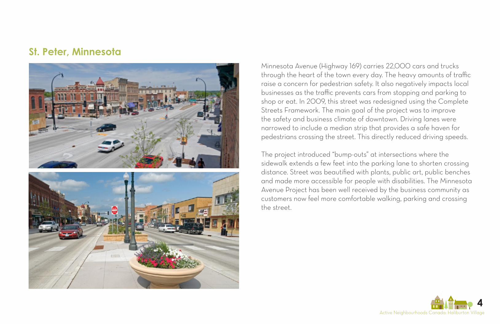
Minnesota Avenue (Highway 169) carries 22,000 cars and trucks through the heart of the town every day. The heavy amounts of traffic raise a concern for pedestrian safety. It also negatively impacts local businesses as the traffic prevents cars from stopping and parking to shop or eat. In 2009, this street was redesigned using the Complete Streets Framework. The main goal of the project was to improve the safety and business climate of downtown. Driving lanes were narrowed to include a median strip that provides a safe haven for pedestrians crossing the street. This directly reduced driving speeds.
The project introduced “bump-outs” at intersections where the sidewalk extends a few feet into the parking lane to shorten crossing distance. Street was beautified with plants, public art, public benches and made more accessible for people with disabilities. The Minnesota Avenue Project has been well received by the business community as customers now feel more comfortable walking, parking and crossing the street.
St. Peter, Minnesota
Active Neighbourhoods Canada: Haliburton Village
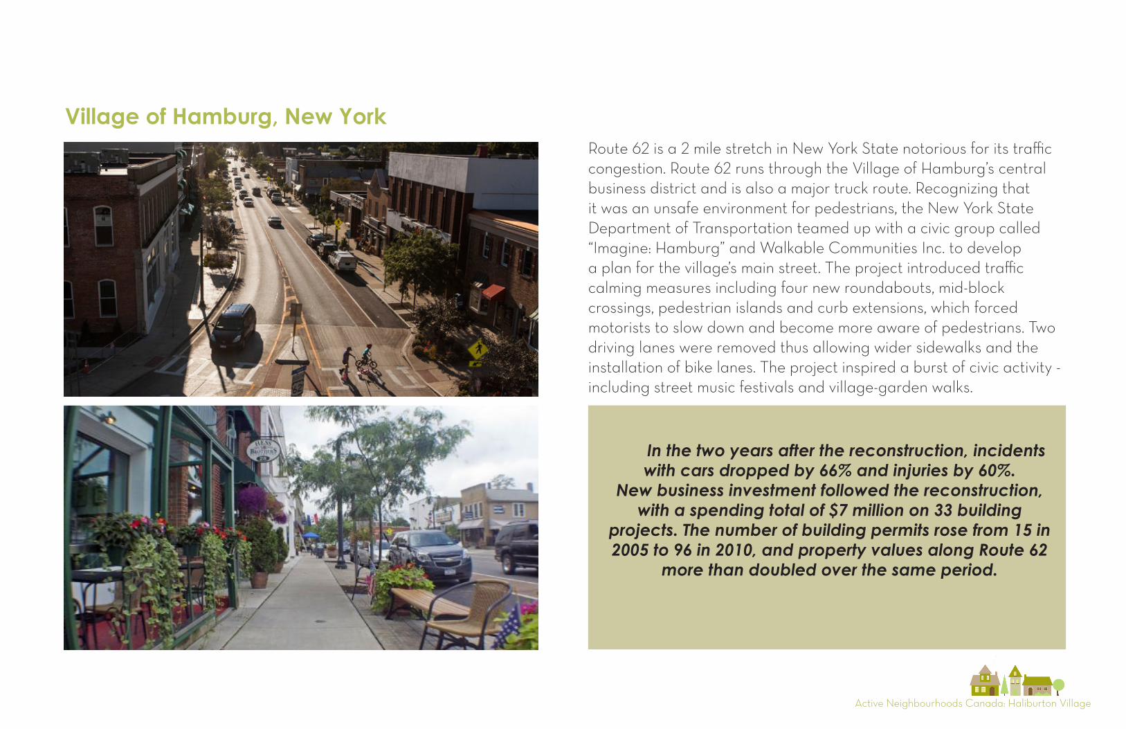
Route 62 is a 2 mile stretch in New York State notorious for its traffic congestion. Route 62 runs through the Village of Hamburg’s central business district and is also a major truck route. Recognizing that it was an unsafe environment for pedestrians, the New York State Department of Transportation teamed up with a civic group called “Imagine: Hamburg” and Walkable Communities Inc. to develop a plan for the village’s main street. The project introduced traffic calming measures including four new roundabouts, mid-block crossings, pedestrian islands and curb extensions, which forced motorists to slow down and become more aware of pedestrians. Two driving lanes were removed thus allowing wider sidewalks and the installation of bike lanes. The project inspired a burst of civic activity - including street music festivals and village-garden walks.
In the two years after the reconstruction, incidents with cars dropped by 66% and injuries by 60%.
New business investment followed the reconstruction, with a spending total of $7 million on 33 building
projects. The number of building permits rose from 15 in 2005 to 96 in 2010, and property values along Route 62
more than doubled over the same period.
Village of Hamburg, New York
Active Neighbourhoods Canada: Haliburton Village
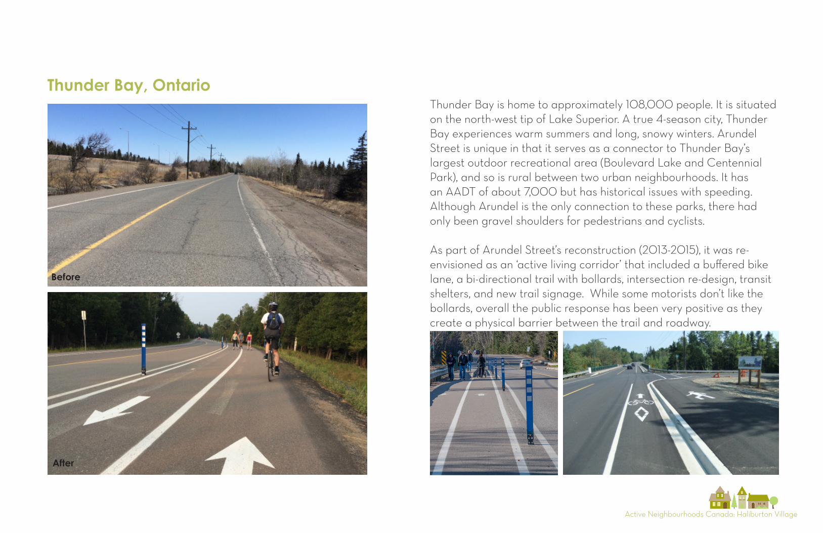
Thunder Bay, OntarioThunder Bay is home to approximately 108,000 people. It is situated on the north-west tip of Lake Superior. A true 4-season city, Thunder Bay experiences warm summers and long, snowy winters. Arundel Street is unique in that it serves as a connector to Thunder Bay’s largest outdoor recreational area (Boulevard Lake and Centennial Park), and so is rural between two urban neighbourhoods. It has an AADT of about 7,000 but has historical issues with speeding. Although Arundel is the only connection to these parks, there had only been gravel shoulders for pedestrians and cyclists. As part of Arundel Street’s reconstruction (2013-2015), it was re-envisioned as an ‘active living corridor’ that included a buffered bike lane, a bi-directional trail with bollards, intersection re-design, transit shelters, and new trail signage. While some motorists don’t like the bollards, overall the public response has been very positive as they create a physical barrier between the trail and roadway.
Before
After
Active Neighbourhoods Canada: Haliburton Village
Summary of Key Challenges & Opportunities
1. In a rural environment, people are generally more dependent on motor vehicule travel than in urban settings, this may affect the ability to gain broad public support for Complete Streets designs
2. County Road 21 is a cross-jurisdictional space between the County and the Municipality, thus decision making for infrastructure change, as well as issues of cost and maintenance can be complex
3. CR21 must accommodate a wide variety of users, and the flow of traffic changes dramatically from the summer to the winter, the design must take into account a varying level of service for all types of users
4. People are generally critical of the bridge crossing, however this was recently rebuilt, and any significant changes to it are less likely in the near future
Challenges Opportunities
1. There is an active and effective social movement towards greater safety for cyclists and pedestrians on the road
2. New development to the west of the Village is creating new destinations and new opportuntities to extend the walkability of the heart from the Village towards the west.
3. Based on similar rural case studies, there is strong evidence that improvements for pedestrians and cyclists on CR21 will also be good for business, as it will encourage more people to stop in town instead of speeding through
4. There is a plethora of recreational trails nearby. If they were networked and properly maintained they could begin to encourage more active transportation