harrah’s station square casino - pgcb.state.pa.us · transportation analysis harrah’s station...
TRANSCRIPT

Transportation Analysis
Harrah’s Station Square Casino Pittsburgh, Pennsylvania
Submitted To: City of Pittsburgh and Pennsylvania Gaming Control Board
Prepared By: DKS Associates GAI Consultants
December 2005 Expanded and Updated October 2006
Addendum 1 2018 Conditions
November 2006
Harrah’s Station Square Casino -Transportation Summary – Addendum 1 November 2006
Transportation Analysis
Harrah’s Station Square Casino
Pittsburgh, Pennsylvania
Submitted To:
City of Pittsburgh and
Pennsylvania Gaming Control Board
Prepared By:
DKS Associates GAI Consultants
December 2005
Expanded and Updated October 2006 Addendum 1
2018 Conditions November 2006
Harrah’s Station Square Casino -Transportation Summary – Addendum 1 November 2006
Table of Contents
2.1 Existing Conditions…………………………..…………..……1
Daily Traffic
3.1 Transportation Characteristics of the Casino, Hotel and Condominiums………………………………..……2
Proposed Development Program Trip Generation Estimates Vehicle Trip Generation
4.1 Transportation Improvement Program………………….….3
Street and Intersection Improvements
6.1 Evaluation of Area Roadway System for 2018………….…4
Appendix
List of Figures and Tables Figures
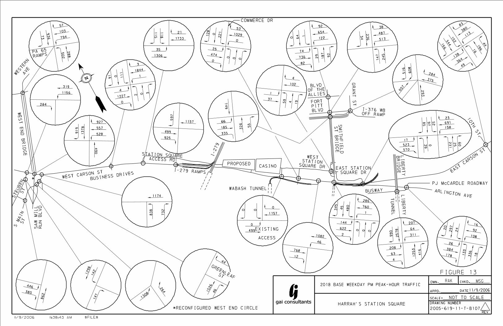
13. 2018 Base Weekday PM Peak-Hour Traffic 14. 2018 Base Friday PM Peak-Hour Traffic 15. 2018 Base Saturday PM Peak-Hour Traffic 16. 2018 Build Weekday PM Peak-Hour Traffic 17. 2018 Build Friday PM Peak-Hour Traffic 18. 2018 Build Saturday PM Peak-Hour Traffic
Tables
7. Non-Friday Weekday PM Peak-Hour Signalized Intersection Level of Service
8. Non-Friday Weekday PM Peak-Hour Unsignalized Intersection Level of Service
9. Friday PM Peak-Hour Signalized Intersection Level of Service 10. Friday PM Peak-Hour Unsignalized Intersection Level of Service 11. Saturday Evening Peak-Hour Signalized Intersection Level of Service 12. Saturday Evening Peak-Hour Unsignalized Intersection Level of Service 13. 2018 Non-Friday Peak-Hour Signalized Intersection 95th Percentile Traffic
Queues
Harrah’s Station Square Casino -Transportation Summary – Addendum 1 November 2006
14. 2018 Friday PM Peak-Hour Signalized Intersection 95th Percentile Traffic Queues
15. 2018 Saturday PM Peak-Hour Signalized Intersection 95th Percentile Traffic Queues
16. 2018 Peak-Hour Queue Length Calculations for Existing Turn Bays 17. 2018 Peak-Hour Queue Length Calculations for Proposed Turn Bays
Harrah’s Station Square Casino – Transportation Report – Addendum 1 Page 1 of 30 November 2006
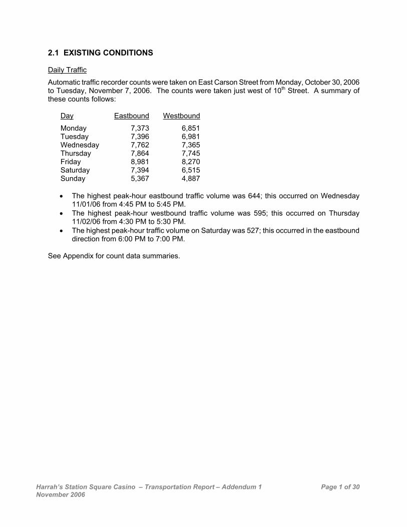
2.1 EXISTING CONDITIONS Daily Traffic
Automatic traffic recorder counts were taken on East Carson Street from Monday, October 30, 2006 to Tuesday, November 7, 2006. The counts were taken just west of 10th Street. A summary of these counts follows:
Day Eastbound Westbound
Monday 7,373 6,851Tuesday 7,396 6,981Wednesday 7,762 7,365Thursday 7,864 7,745Friday 8,981 8,270Saturday 7,394 6,515Sunday 5,367 4,887
• The highest peak-hour eastbound traffic volume was 644; this occurred on Wednesday
11/01/06 from 4:45 PM to 5:45 PM. • The highest peak-hour westbound traffic volume was 595; this occurred on Thursday
11/02/06 from 4:30 PM to 5:30 PM. • The highest peak-hour traffic volume on Saturday was 527; this occurred in the eastbound
direction from 6:00 PM to 7:00 PM. See Appendix for count data summaries.
Harrah’s Station Square Casino – Transportation Report – Addendum 1 Page 2 of 30 November 2006
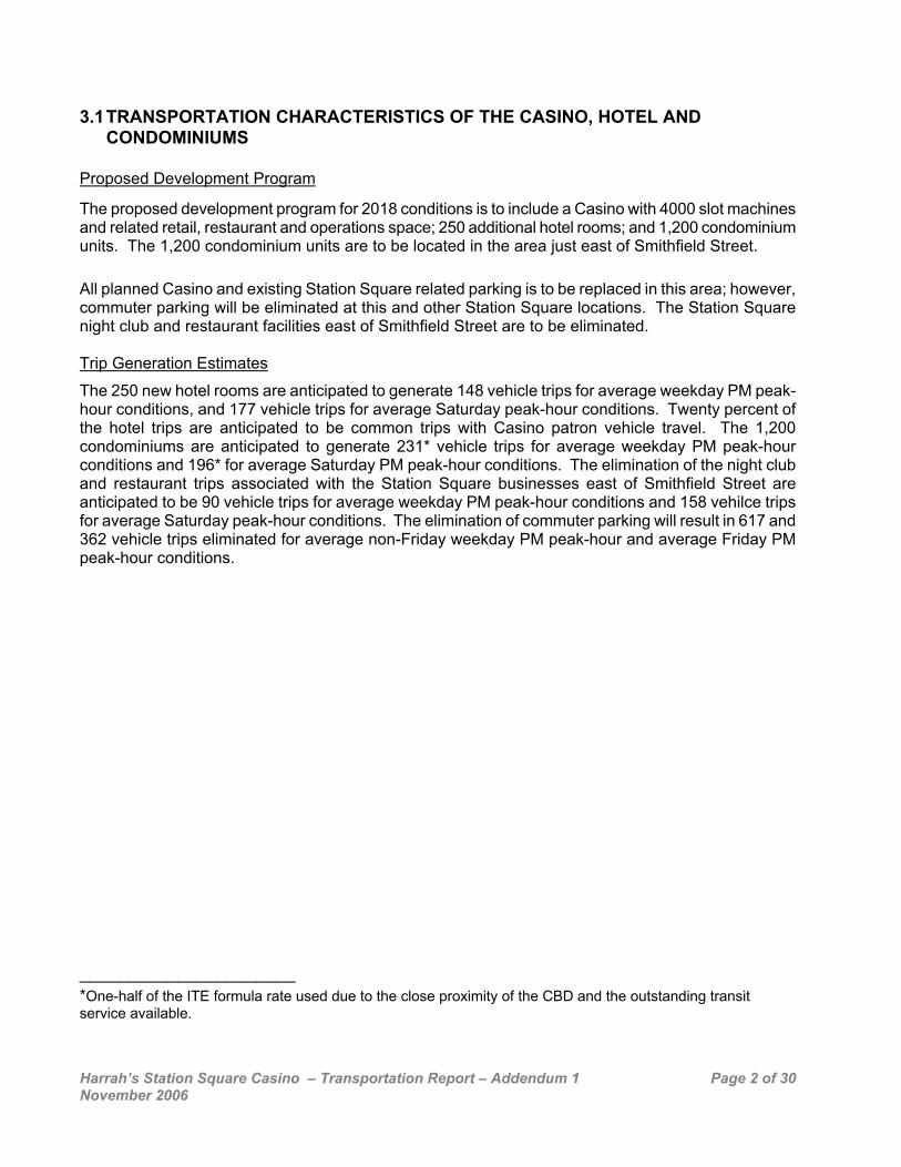
3.1 TRANSPORTATION CHARACTERISTICS OF THE CASINO, HOTEL AND CONDOMINIUMS
Proposed Development Program
The proposed development program for 2018 conditions is to include a Casino with 4000 slot machines and related retail, restaurant and operations space; 250 additional hotel rooms; and 1,200 condominium units. The 1,200 condominium units are to be located in the area just east of Smithfield Street. All planned Casino and existing Station Square related parking is to be replaced in this area; however, commuter parking will be eliminated at this and other Station Square locations. The Station Square night club and restaurant facilities east of Smithfield Street are to be eliminated. Trip Generation Estimates
The 250 new hotel rooms are anticipated to generate 148 vehicle trips for average weekday PM peak-hour conditions, and 177 vehicle trips for average Saturday peak-hour conditions. Twenty percent of the hotel trips are anticipated to be common trips with Casino patron vehicle travel. The 1,200 condominiums are anticipated to generate 231* vehicle trips for average weekday PM peak-hour conditions and 196* for average Saturday PM peak-hour conditions. The elimination of the night club and restaurant trips associated with the Station Square businesses east of Smithfield Street are anticipated to be 90 vehicle trips for average weekday PM peak-hour conditions and 158 vehilce trips for average Saturday peak-hour conditions. The elimination of commuter parking will result in 617 and 362 vehicle trips eliminated for average non-Friday weekday PM peak-hour and average Friday PM peak-hour conditions. ______________________ *One-half of the ITE formula rate used due to the close proximity of the CBD and the outstanding transit service available.
Harrah’s Station Square Casino – Transportation Report – Addendum 1 Page 3 of 30 November 2006
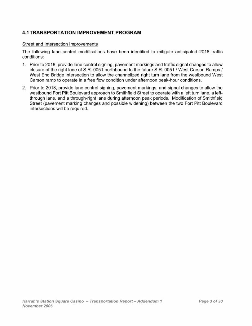
4.1 TRANSPORTATION IMPROVEMENT PROGRAM Street and Intersection Improvements
The following lane control modifications have been identified to mitigate anticipated 2018 traffic conditions:
1. Prior to 2018, provide lane control signing, pavement markings and traffic signal changes to allow closure of the right lane of S.R. 0051 northbound to the future S.R. 0051 / West Carson Ramps / West End Bridge intersection to allow the channelized right turn lane from the westbound West Carson ramp to operate in a free flow condition under afternoon peak-hour conditions.
2. Prior to 2018, provide lane control signing, pavement markings, and signal changes to allow the westbound Fort Pitt Boulevard approach to Smithfield Street to operate with a left turn lane, a left-through lane, and a through-right lane during afternoon peak periods. Modification of Smithfield Street (pavement marking changes and possible widening) between the two Fort Pitt Boulevard intersections will be required.

Harrah’s Station Square Casino – Transportation Report – Addendum 1 Page 4 of 30 November 2006
6.1 EVALUATION OF AREA ROADWAY SYSTEM FOR 2018 Synchro traffic simulation software analyses were conducted for three future conditions and three time periods:
• Proposed Base conditions (with background growth but without the proposed development) for 2018 projected non-Friday weekday PM peak-hour conditions (4:30 PM – 5:30 PM)
• Proposed Base Conditions (with background growth but without the proposed development) for 2018 projected Friday PM peak-hour conditions (4:30 PM-5:30 PM)
• Proposed Base conditions for 2018 projected Saturday gaming peak-hour conditions (5:45 PM – 6:45 PM)
• Build (with casino development) conditions with existing roadway and signalization conditions
• Build conditions with roadway and signalization improvements
The base volumes for 2018 were developed by increasing the non-Station Square traffic by one percent per year. The growth percentage was derived after comparing Station Square area counts taken by GAI in the 1980’s to the new counts and discussing the results and network projections with staff at the Southwestern Pennsylvania Commission. Base condition traffic volumes are shown on Figures 13 through 15. The build conditions were then developed by subtracting the business and commuter parking related traffic that will be eliminated, and adding the development related trips to each intersection for each of the analysis time periods based on anticipated entrance / exit patterns. Build condition traffic volumes are shown on Figures 16 through 18.
Analysis results for 2018 base conditions indicate that eleven study area intersections are anticipated to operate within acceptable levels of service, (LOS), A through D range for the periods analyzed while nine have one or more approaches operating at LOS E or F. The intersections that are anticipated to operate at LOS F under base conditions are the West End Bridge at the West End Circle (non-Friday weekday peak-hour) and Liberty Tunnel/Liberty Bridge at PJ McCardle Roadway (non-Friday weekday, Friday PM and Saturday PM peak-hours).
The intersections that have significant reserve capacity as indicated by LOS A, B, or C operation for anticipated 2018 base conditions are:
• West End Bridge at PA 65 ramps, • South Main Street at South Main Street and S.R. 0051 Ramp, West Carson Street, • West Carson Street at Wabash Tunnel Roadway, • Smithfield Street at the Boulevard of the Allies (problems observed at this intersection were
due to downstream conditions), and • Arlington Avenue at the PJ McCardle Roadway.
Analysis results for 2018 build conditions without improvements indicate that most study area intersections would continue to operate at the LOS letter designation they do under base conditions. However, seven intersections are anticipated to drop LOS letter values. Without improvements, 1. West Carson Street at the western Station Square access road would drop from LOS B to
LOS E for non-Friday weekday PM peak-hour conditions, LOS B to LOS F for Friday PM peak-hour conditions and LOS A to LOS F for Saturday PM peak-hour conditions,
2. Carson Street at Smithfield Street from LOS E to LOS F for weekday PM peak-hour conditions, and LOS D to LOS E for Saturday PM peak-hour conditions,
3. South Main Street at the West Carson Street side of the West End Circle from LOS B to LOS C for Friday PM peak-hour conditions,

Harrah’s Station Square Casino – Transportation Report – Addendum 1 Page 5 of 30 November 2006
Harrah’s Station Square Casino – Transportation Report – Addendum 1 Page 6 of 30 November 2006

Harrah’s Station Square Casino – Transportation Report – Addendum 1 Page 7 of 30 November 2006

Harrah’s Station Square Casino – Transportation Report – Addendum 1 Page 8 of 30 November 2006

Harrah’s Station Square Casino – Transportation Report – Addendum 1 Page 9 of 30 November 2006

Harrah’s Station Square Casino – Transportation Report – Addendum 1 Page 10 of 30 November 2006
Harrah’s Station Square Casino – Transportation Report – Addendum 1 Page 11 of 30 November 2006
4. Fort Pitt Boulevard at Grant Street from LOS D to LOS E for non-Friday weekday PM peak-
hour conditions, LOS C to LOS D for Friday PM peak-hour conditions and LOS C to LOS E for Saturday PM peak-hour conditions,
5. Smithfield Street at eastbound Fort Pitt Boulevard from LOS C to LOS E for non-Friday weekday PM peak-hour conditions and LOS C to LOS D for Friday PM peak-hour conditions,
6. East Carson Street at 10th Street from LOS C to LOS D for Saturday PM peak-hour conditions,
7. Smithfield Street at westbound Fort Pitt Boulevard from LOS E to LOS F for non-Friday weekday PM peak-hour conditions, LOS D to LOS F for Friday PM peak-hour conditions and LOS B to LOS C for Saturday PM peak-hour conditions.
Improvements are proposed to mitigate the deterioration of the LOS at study area intersections and provide acceptable LOS at new entrance / exit intersections.
These improvements were presented in the previous section describing the transportation improvement program. Analysis results for 2018 build conditions with the previously indicated roadway and signalization improvements indicate that the study area intersections would operate within acceptable levels of service (LOS), A through D range, for the periods analyzed except:
• West End Bridge at the West End Circle • Smithfield Street at westbound Fort Pitt Boulevard • Liberty Tunnel / Liberty Bridge / PJ McCardle intersection • East Carson Street at 10th Street.
Construction of modifications to the West End Circle (a PennDOT project scheduled to resume early in 2007) will improve LOS values for most problem intersections within the circle. Improvements will allow the intersections of West Carson Street at the western access roadway, Carson Street at Smithfield Street, and East Carson Street at Arlington Avenue to operate at LOS D or better for the three peak-hour conditions evaluated. Improvements including signal timing changes will improve level-of-service values and decrease delays at other study intersections.
For existing and proposed queue lengths for traffic movements at each of the study intersections, refer to the “Queue Length 95th (ft)” line in the “Queues” reports in the Appendix. The calculations for the required length of proposed turn bays can also be found in the Appendix.
Harrah’s Station Square Casino – Transportation Report – Addendum 1 Page 12 of 30 November 2006
Level-of-Service results are summarized in the following tables. Table 7 - 2018 Non-Friday PM Peak-Hour Signalized Intersection Level of Service
Intersection Approach Base Build Improved NB C C - SB D C - WB D D -
West End Bridge/ Western Avenue & PA 65 Ramps
Total C C - NB A A A SB 292.9 F 300.6 F 175.2 F WB 139.2 F 148.9 F E
West End Bridge & West Carson Street (Reconstructed WEC)
Total 199.2 F 207.4 F 117.6 F NB C C C
NEB A B B South Main Street & SR 0051 Ramp (Reconstructed WEC) Total B B B
NB C C C WB C C C
South Main Street & West Carson Street (Reconstructed WEC) Total C C C
NB D D C SB 158.4 F 157.1 F D EB A A A WB A A B
West Carson Street & Signalized Intersection West of Station Square Access Road1
Total B B B SB D D D EB A B A WB C 131.7 F B
West Carson Street & Station Square Access Road
Total B E B SB - C C EB - A A WB - A A
West Carson Street & Casino Drive
Total - A A NB A A A SB C D C EB A A A WB B A A
West Carson Street & Commerce Drive/Parking Lot
Total B A A NB A A A SB A A A EB A A A WB A A A
West Carson Street & Wabash Tunnel Roadway
Total A A A NB A A A SB 136.6 F 199.7 F C EB B C C WB B B B
Carson Street & Smithfield Street/ Busway
Total E 87.8 F C
1 Assumed intersection timings based upon proportion of traffic.

Harrah’s Station Square Casino – Transportation Report – Addendum 1 Page 13 of 30 November 2006
NB C C C SB A A A EB E 154.2 F E
Smithfield Street & Eastbound Fort Pitt Boulevard
Total C E C NB B A B SB E E E WB 80.9 F 134.3 F E
Smithfield Street & Westbound Fort Pitt Boulevard
Total E 89.6 F E NB B B - SB B B - EB C C - WB C C -
Smithfield Street & Boulevard of the Allies
Total C C - NB C C C
NEB 101.9 F 101.9 F E SB B B B WB E 154.1 F D
Fort Pitt Boulevard & Grant Street
Total D E D NEB D D D NWB D D D SB D D C EB 88.2 F D C WB D D C
East Carson Street & Busway/Arlington Avenue/ East Station Square Drive
Total E D D NB B B - SB C C - EB C C - WB B B -
Arlington Avenue & PJ McCardle Roadway
Total C B - NB 117.0 F 114.5 F 112.7 F SB 158.6 F 158.6 F 157.5 F EB 108.0 F 108.0 F 105.7 F WB 299.5 F 310.3 F 296.9 F
Liberty Tunnel/Liberty Bridge & PJ McCardle Roadway
Total 158.0 F 158.3 F 155.8 F NB B B C SB D D D EB C B C WB 94.0 F 107.6 F E
East Carson Street & 10th Street
Total D D D Each intersection included in the traffic analysis is discussed below: West End Bridge / Western Avenue Connector & PA 65 Ramps Operates as a signalized “+” intersection. Dual left turn lanes are provided at the West End Bridge northbound approach and dual through lanes and a channelized right turn lane are provided at the Western Avenue Connector southbound approach. PA 65 is one-way westbound with dual left turn lanes, a through lane and channelized right turn lane provided. No mitigation required.
Harrah’s Station Square Casino – Transportation Report – Addendum 1 Page 14 of 30 November 2006
West End Bridge & West Carson Street (Reconstructed West End Circle) It is anticipated that this intersection will be reconfigured as part of the West End Improvement Program in 2009. The reconfigured intersection would provide a left-turn lane, two through lanes, a through-right lane, and a channelized right turn lane at the West Carson Street westbound approach. The West End Bridge southbound approach would provide a through lane and right turn lane and SR 0051 would connect to the south providing dual through lanes. Mitigation includes repainting the West Carson Street approach to provide for dual left turn lanes, dual through lanes and a channelized right turn lane. Also, provide lane control signing to close the northbound right lane approaching the signal from SR 0051during PM peak-hour conditions to reduce the approach to a single through lane. This would allow for the channelized westbound right turn lane to run free-flowing as a lane add northbound onto the bridge. South Main Street & SR 0051 Off Ramp (Reconstructed West End Circle) Operate as a signalized inverted “Y” intersection. Dual through lanes are provided at the SR 0051 Off Ramp northbound approach and the northeast bound South Main Street approach. This intersection will be constructed as part of the West End Improvement Program. No mitigation required with optimized signal timings.
South Main Street & West Carson Street (Reconstructed West End Circle) Operates as a signalized “T” intersection. West Carson Street is one-way westbound with dual through lanes and South Main Street is one-way northbound with three left turn lanes and a channelized right turn lane. This intersection will remain unchanged with the West End Improvement Program. No mitigation required with optimized signal timings. West Carson Street & Signalized Intersection West of Station Square Access Road Operates as a signalized “+” intersection. A left turn lane, through lane and through-right lane are provided at the West Carson Street eastbound approach. A left-through lane and through-right lane are provided at the West Carson Street westbound approach. Both north and southbound business approaches are single lanes. No mitigation required with optimized signal timings. West Carson Street & West Station Square Access Road Operates as a signalized “T” intersection. A left turn lane and dual through lanes are provided at the West Carson Street eastbound approach and a through lane and through-right lane are provided at the West Carson Street westbound approach. A left turn lane and right turn lane are provided at the Station Square Access Road southbound approach. Mitigation includes a new southbound left turn lane to provide for two left turn lanes with 220 feet of storage and a right turn lane. Also, a new channelized westbound right turn lane is required to provide for dual through lanes and a right turn lane (to be entrance yield controlled onto the Station Square Access Road). West Carson Street & Casino Drive Operates as an unsignalized “T” intersection. This is the location of the proposed Main Entrance to the new Casino. The southbound approach will be widened for three outbound lanes and two inbound lanes. A 160-foot eastbound left turn lane should be constructed on West Carson Street and signalization should be implemented at this intersection with coordination to the traffic signals at Commerce Drive, the Wabash Tunnel Roadway, Smithfield Street and Arlington Avenue. No additional improvements required.
Harrah’s Station Square Casino – Transportation Report – Addendum 1 Page 15 of 30 November 2006
West Carson Street & Commerce Drive / Parking Lot Operates as a signalized “+” intersection. A left turn lane, through lane and through-right lane are provided at both the West Carson Street eastbound and westbound approaches. Left-through and right turn lanes are provided at the southbound Commerce Drive approach and the northbound approach is a single lane. The recommended improvement is to widen the southbound approach to provide a left turn lane, left-through lane and right turn lane, and to close the center median. The two inbound lanes will be reduced to a wide single lane. West Carson Street & the Wabash Tunnel Roadway Operates as a signalized “+” intersection. A left-through lane and through-right lane are provided at both the West Carson Street eastbound and westbound approaches. The northbound Wabash Tunnel Roadway and southbound access road are single lanes. During all conditions analyzed, the Wabash Tunnel Roadway is one-lane outbound only. No mitigation is required. Carson Street & Smithfield Street / Busway Operates as a signalized “+” intersection. A left-through lane and through-right lane are provided at both the West Carson Street eastbound and westbound approaches. A left turn lane, through lane and right turn lane are provided at the southbound Smithfield Street approach. The south approach has no northbound traffic into the intersection. The recommendations include a new southbound right turn lane from the southern terminus of the Smithfield Street Bridge to provide for a left turn lane, through lane and dual right turn lanes. In addition, a new westbound right-turn lane will be added beginning at the East Carson Street and Busway / Arlington Avenue / East Station Square Drive intersection. Smithfield Street & Eastbound / Westbound Fort Pitt Boulevard Operates as two signalized “+” intersections with short storage between the intersections. During the PM a through lane and through-right lane are provided at the northbound Smithfield Street Bridge approach. The southbound Smithfield Street approach is a single lane. A left-through and right turn lane are provided at the Fort Pitt Boulevard eastbound approach, and a left turn lane, through lane and right turn lane are provided at the Fort Pitt Boulevard westbound approach. Mitigation requires the conversion of the westbound approach (PM only) to a left-turn lane, left-through lane and through-right lane. The pavement markings on Smithfield Street between the two intersections will need to be modified. Widening of this short section of roadway would be beneficial. Parking and stopping restrictions would be required on westbound Fort Pitt Boulevard downstream of the intersection. Smithfield Street & Boulevard of the Allies Operates as a signalized “+” intersection. A left turn lane, through lane and through-right lane are provided at both the eastbound and westbound Boulevard of the Allies approaches. A left-through lane and through-right lane are provided at the northbound Smithfield Street approach. The southbound Smithfield Street approach is a single lane. No mitigation required. Fort Pitt Boulevard & Grant Street Operates as a signalized, multi-leg intersection. A through lane and right turn lane are provided at both the southbound Grant Street and northwest bound I-376 Off Ramp approaches. Both the northeast bound Fort Pitt Boulevard and northbound I-376 Eastbound Off Ramp approaches are single lanes. Signal timing changes are needed at this intersection. Modification of signal timings is the required mitigation.
Harrah’s Station Square Casino – Transportation Report – Addendum 1 Page 16 of 30 November 2006
East Carson Street & Busway / Arlington Avenue / East Station Square Drive Operates as a signalized, five-approach intersection. A left-through lane and through-right lane are provided at the East Carson Street eastbound approach and a left turn lane and through-right lane are provided at the East Carson Street westbound approach. A through lane and through-right lane are provided at the Arlington Avenue northwest bound approach and a left turn lane and right turn lane are provided at the southbound East Station Square Drive approach. The northeast bound Busway approach is a single lane. The recommended improvement includes a new 100-foot southbound left turn lane to provide for dual left turn lanes and a right turn lane. Arlington Avenue & PJ McCardle Roadway Operates as a signalized “+” intersection. A left turn lane, through lane and right turn lane are provided at the eastbound Arlington Avenue approach and a left-turn lane and through-right turn lane are provided at the westbound Arlington Avenue approach. A left turn lane and through-right lane are provided at the northbound PJ McCardle approach and a left-through lane and through-right lane are provided at the southbound PJ McCardle approach. No mitigation required. Liberty Tunnel / Liberty Bridge & PJ McCardle Roadway Operates as a signalized “+” intersection. During high demand for southbound travel a through lane and through-right lane are provided at the northbound Liberty Tunnel approach and dual through lanes and a right turn lane are provided at the southbound Liberty Bridge approach. A left turn lane and left-through-right lane are provided at the westbound PJ McCardle approach. The eastbound PJ McCardle approach is a single lane. Mitigation is not possible at this intersection. To serve present and future demand, an additional through lane is needed for southbound Liberty Tunnel travel. This widening option has been rejected many times in the transportation system planning processes. System improvements at other locations that will help reduce travel demand for Liberty Tunnel use include the improvements under construction at the West End Circle and the Mon / Fayette Expressway. The addition of a westbound right-turn lane would also help accommodate travel demand at this intersection; however, it is not constructable due to physical constraints. Signal timing modifications will reduce the delay with build conditions, but not to achieve base condition results for all approaches. East Carson Street & 10th Street Operates as a signalized “+” intersection. A left turn lane and through-right lane are provided at both the eastbound and westbound East Carson Street approaches. A left-through and through-right lane is provided at the southbound 10th Street approach. The northbound 10th Street approach is a single lane. Signal timing changes are needed at this intersection. Modification of signal timings is the required mitigation.
Table 8 - 2018 Non-Friday PM Peak-Hour Unsignalized Intersection Level of Service
2018 Intersection Approach Base Build Improved NB A A A South Main Street &
Connector (Rec. WEC) SB C C C SB A - - EB A - -
West Carson Street & Roadway West of Parking Garage WB A - -
NB A A A EB A A A
West Station Square Drive & Smithfield Street Ramp
WB A A A
Harrah’s Station Square Casino – Transportation Report – Addendum 1 Page 17 of 30 November 2006
Table 9 - 2018 Friday PM Peak-Hour Signalized Intersection Level of Service
Intersection Approach Base Build Improved NB C C - SB C C - WB D D -
West End Bridge/ Western Avenue & PA 65 Ramps
Total C C - NB A A A SB 99.9 F 104.9 F D WB D E C
West End Bridge & West Carson Street (Reconstructed WEC)
Total E E C NB C C C
NEB B B B South Main Street & SR 0051 Ramp (Reconstructed WEC) Total B B B
NB B B B WB C C C
South Main Street & West Carson Street (Reconstructed WEC) Total B C B
NB D D C SB E E C EB A A A WB A A A
West Carson Street & Signalized Intersection West of Station Square Access Road2
Total A A A SB D 123.1 F D EB A B B WB B 138.4 F C
West Carson Street & Station Square Access Road
Total B 88.2 F C SB - B C EB - A A WB - A A
West Carson Street & Casino Drive
Total - A A NB C D C SB D D C EB B B B WB B B B
West Carson Street & Commerce Drive/Parking Lot
Total B B B NB A A A SB A A A EB A A A WB A A A
West Carson Street & Wabash Tunnel Roadway
Total A A A NB A A A SB 151.1 F 249.1 F 88.0 F EB C D C WB B B A
Carson Street & Smithfield Street/ Busway
Total E 109.0 F D
2 Assumed intersection timings based upon proportion of traffic.
Harrah’s Station Square Casino – Transportation Report – Addendum 1 Page 18 of 30 November 2006
NB C C C SB A A A EB D 127.7 F E
Smithfield Street & Eastbound Fort Pitt Boulevard
Total C D C NB A A A SB D D E WB E 125.8 F E
Smithfield Street & Westbound Fort Pitt Boulevard
Total D 80.5 F D NB B B B SB B B B EB C C C WB C C C
Smithfield Street & Boulevard of the Allies
Total C C C NB C C C
NEB D D D SB B B C WB E 116.6 F C
Fort Pitt Boulevard & Grant Street
Total C D C NEB E D E NWB D D D SB E D D EB 80.9 F 100.4 F E WB D E C
East Carson Street & Busway/Arlington Avenue/ East Station Square Drive
Total E E D NB B B B SB C C C EB C C C WB B B B
Arlington Avenue & PJ McCardle Roadway
Total C C C NB 125.9 F 124.3 F 120.5 F SB 215.6 F 215.6 F 213.4 F EB 135.2 F 135.2 F 293.5 F WB 465.0 F 507.4 F 278.5 F
Liberty Tunnel/Liberty Bridge & PJ McCardle Roadway
Total 213.0 F 217.9 F 198.0 F NB B B C SB 110.7 F 113.5 F E EB C C C WB 89.2 F 104.1 F E
East Carson Street & 10th Street
Total E E E
Harrah’s Station Square Casino – Transportation Report – Addendum 1 Page 19 of 30 November 2006
Table 10 - 2018 Friday PM Peak Hour Unsignalized Intersection Levels of Service
2018 Intersection Approach Base Build Improved NB A A A South Main Street &
Connector (Rec. WEC) SB C D D SB B - - EB A - -
West Carson Street & Roadway West of Parking Garage WB A - -
NB A B A EB A A A
West Station Square Drive & Smithfield Street Ramp
WB A A A Table 11 - 2018 Average Saturday PM Peak-Hour Signalized Intersection Levels of
Service Intersection Approach Base Build Improved
NB B B - SB B B - WB B B -
West End Bridge/ Western Avenue & PA 65 Ramps
Total B B - NB C B C SB C C B WB A A A
West End Bridge & West Carson Street (Reconstructed WEC)
Total B B B NB C C B
NEB A A B South Main Street & SR 0051 Ramp (Reconstructed WEC) Total B B B
NB A A B WB C C B
South Main Street & West Carson Street (Reconstructed WEC) Total B B B
NB D D B SB D D B EB A A A WB A A A
West Carson Street & Signalized Intersection West of Station Square Access Road3
Total A A A SB D 410.3 F D EB A C B WB A E B
West Carson Street & Station Square Access Road
Total A 118.3 F C SB - B C EB - A A WB - A A
West Carson Street & Casino Drive
Total - A A
3 Assumed intersection timings based upon proportion of traffic.
Harrah’s Station Square Casino – Transportation Report – Addendum 1 Page 20 of 30 November 2006
NB A A A SB C D C EB B B A WB A B A
West Carson Street & Commerce Drive/Parking Lot
Total B B A NB A A A SB A A A EB A A A WB A A A
West Carson Street & Wabash Tunnel Roadway
Total A A A NB 90.0 F 90.0 F E SB 98.2 F 188.8 F E EB B D C WB B B B
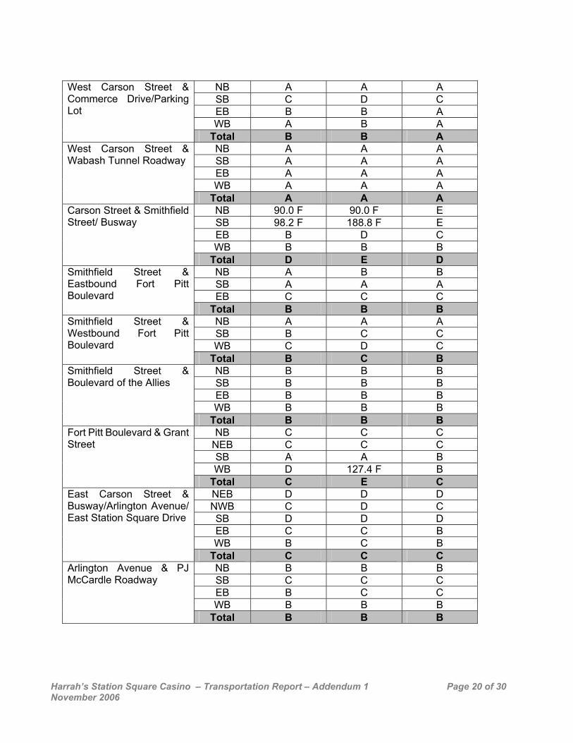
Carson Street & Smithfield Street/ Busway
Total D E D NB A B B SB A A A EB C C C
Smithfield Street & Eastbound Fort Pitt Boulevard
Total B B B NB A A A SB B C C WB C D C
Smithfield Street & Westbound Fort Pitt Boulevard
Total B C B NB B B B SB B B B EB B B B WB B B B
Smithfield Street & Boulevard of the Allies
Total B B B NB C C C
NEB C C C SB A A B WB D 127.4 F B
Fort Pitt Boulevard & Grant Street
Total C E C NEB D D D NWB C D C SB D D D EB C C B WB B C B
East Carson Street & Busway/Arlington Avenue/ East Station Square Drive
Total C C C NB B B B SB C C C EB B C C WB B B B
Arlington Avenue & PJ McCardle Roadway
Total B B B
Harrah’s Station Square Casino – Transportation Report – Addendum 1 Page 21 of 30 November 2006
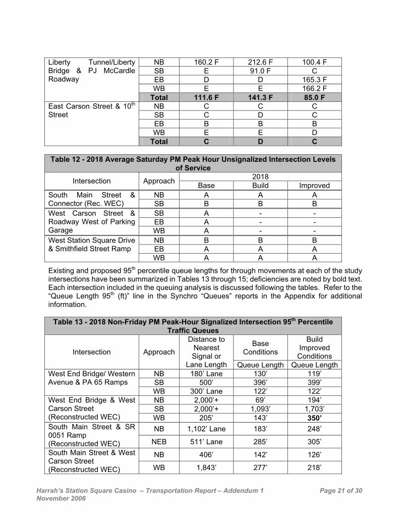
NB 160.2 F 212.6 F 100.4 F SB E 91.0 F C EB D D 165.3 F WB E E 166.2 F
Liberty Tunnel/Liberty Bridge & PJ McCardle Roadway
Total 111.6 F 141.3 F 85.0 F NB C C C SB C D C EB B B B WB E E D
East Carson Street & 10th Street
Total C D C Table 12 - 2018 Average Saturday PM Peak Hour Unsignalized Intersection Levels
of Service 2018 Intersection Approach Base Build Improved
NB A A A South Main Street & Connector (Rec. WEC) SB B B B
SB A - - EB A - -
West Carson Street & Roadway West of Parking Garage WB A - -
NB B B B EB A A A
West Station Square Drive & Smithfield Street Ramp
WB A A A
Existing and proposed 95th percentile queue lengths for through movements at each of the study intersections have been summarized in Tables 13 through 15; deficiencies are noted by bold text. Each intersection included in the queuing analysis is discussed following the tables. Refer to the “Queue Length 95th (ft)” line in the Synchro “Queues” reports in the Appendix for additional information.
Table 13 - 2018 Non-Friday PM Peak-Hour Signalized Intersection 95th Percentile Traffic Queues
Base Conditions
Build Improved
Conditions Intersection Approach
Distance to Nearest Signal or
Lane Length Queue Length Queue LengthNB 180’ Lane 130’ 119’ SB 500’ 396’ 399’
West End Bridge/ Western Avenue & PA 65 Ramps
WB 300’ Lane 122’ 122’ NB 2,000’+ 69’ 194’ SB 2,000’+ 1,093’ 1,703’
West End Bridge & West Carson Street (Reconstructed WEC) WB 205’ 143’ 350’
NB 1,102’ Lane 183’ 248’ South Main Street & SR 0051 Ramp (Reconstructed WEC) NEB 511’ Lane 285’ 305’
NB 406’ 142’ 126’ South Main Street & West Carson Street (Reconstructed WEC) WB 1,843’ 277’ 218’
Harrah’s Station Square Casino – Transportation Report – Addendum 1 Page 22 of 30 November 2006
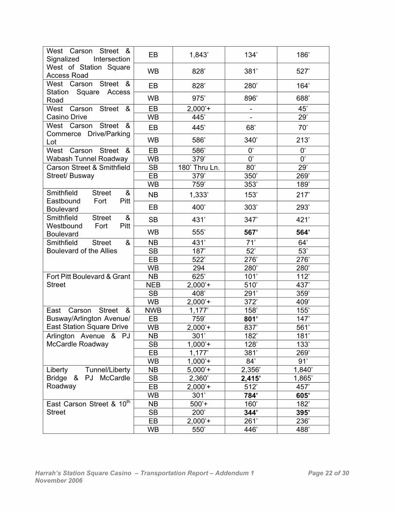
EB 1,843’ 134’ 186’ West Carson Street & Signalized Intersection West of Station Square Access Road WB 828’ 381’ 527’
EB 828’ 280’ 164’ West Carson Street & Station Square Access Road WB 975’ 896’ 688’
EB 2,000’+ - 45’ West Carson Street & Casino Drive WB 445’ - 29’
EB 445’ 68’ 70’ West Carson Street & Commerce Drive/Parking Lot WB 586’ 340’ 213’
EB 586’ 0’ 0’ West Carson Street & Wabash Tunnel Roadway WB 379’ 0’ 0’
SB 180’ Thru Ln. 80’ 29’ EB 379’ 350’ 269’
Carson Street & Smithfield Street/ Busway
WB 759’ 353’ 189’ NB 1,333’ 153’ 217’ Smithfield Street &
Eastbound Fort Pitt Boulevard EB 400’ 303’ 293’
SB 431’ 347’ 421’ Smithfield Street & Westbound Fort Pitt Boulevard WB 555’ 567’ 564’
NB 431’ 71’ 64’ SB 187’ 52’ 53’ EB 522’ 276’ 276’
Smithfield Street & Boulevard of the Allies
WB 294 280’ 280’ NB 625’ 101’ 112’
NEB 2,000’+ 510’ 437’ SB 408’ 291’ 359’
Fort Pitt Boulevard & Grant Street
WB 2,000’+ 372’ 409’ NWB 1,177’ 158’ 155’ EB 759’ 801’ 147’
East Carson Street & Busway/Arlington Avenue/ East Station Square Drive WB 2,000’+ 837’ 561’
NB 301’ 182’ 181’ SB 1,000’+ 128’ 133’ EB 1,177’ 381’ 269’
Arlington Avenue & PJ McCardle Roadway
WB 1,000’+ 84’ 91’ NB 5,000’+ 2,356’ 1,840’ SB 2,360’ 2,415’ 1,865’ EB 2,000’+ 512’ 457’
Liberty Tunnel/Liberty Bridge & PJ McCardle Roadway
WB 301’ 784’ 605’ NB 500’+ 160’ 182’ SB 200’ 344’ 395’ EB 2,000’+ 261’ 236’
East Carson Street & 10th Street
WB 550’ 446’ 488’
Harrah’s Station Square Casino – Transportation Report – Addendum 1 Page 23 of 30 November 2006
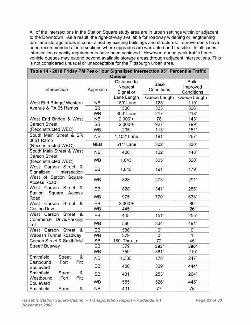
All of the intersections in the Station Square study area are in urban settings within or adjacent to the Downtown. As a result, the right-of-way available for roadway widening or lengthening turn lane storage areas is constrained by existing buildings and structures. Improvements have been recommended at intersections where upgrades are warranted and feasible. In all cases, intersection capacity requirements have been achieved. However, during peak traffic hours, vehicle queues may extend beyond available storage areas through adjacent intersections. This is not considered unusual or unacceptable for the Pittsburgh urban area.
Table 14 - 2018 Friday PM Peak-Hour Signalized Intersection 95th Percentile Traffic Queues
Base Conditions
Build Improved
Conditions Intersection Approach
Distance to Nearest Signal or
Lane Length Queue Length Queue LengthNB 180’ Lane 123’ 119’ SB 500’ 323’ 326’
West End Bridge/ Western Avenue & PA 65 Ramps
WB 300’ Lane 217’ 218’ NB 2,000’+ 78’ 143’ SB 2,000’+ 927’ 799’
West End Bridge & West Carson Street (Reconstructed WEC) WB 205’ 113’ 151’
NB 1,102’ Lane 191’ 267’ South Main Street & SR 0051 Ramp (Reconstructed WEC) NEB 511’ Lane 302’ 330’
NB 406’ 122’ 148’ South Main Street & West Carson Street (Reconstructed WEC) WB 1,843’ 305’ 320’
EB 1,843’ 191’ 179’ West Carson Street & Signalized Intersection West of Station Square Access Road WB 828’ 273’ 291’
EB 828’ 341’ 286’ West Carson Street & Station Square Access Road WB 975’ 770’ 638’
EB 2,000’+ - 80’ West Carson Street & Casino Drive WB 445’ - 26’
EB 445’ 151’ 255’ West Carson Street & Commerce Drive/Parking Lot WB 586’ 334’ 491’
EB 586’ 0’ 0’ West Carson Street & Wabash Tunnel Roadway WB 379’ 0’ 1’
SB 180’ Thru Ln. 72’ 45’ EB 379’ 393’ 390’
Carson Street & Smithfield Street/ Busway
WB 759’ 381’ 210’ NB 1,333’ 178’ 247’ Smithfield Street &
Eastbound Fort Pitt Boulevard EB 400’ 309’ 444’
SB 431’ 253’ 264’ Smithfield Street & Westbound Fort Pitt Boulevard WB 555’ 526’ 445’ Smithfield Street & NB 431’ 77’ 75’

Harrah’s Station Square Casino – Transportation Report – Addendum 1 Page 24 of 30 November 2006
SB 187’ 51’ 53’ EB 522’ 304’ 304’
Boulevard of the Allies
WB 294’ 271’ 271’ NB 625’ 114’ 118’
NEB 2,000’+ 314’ 266’ SB 408’ 343’ 465’
Fort Pitt Boulevard & Grant Street
WB 2,000’+ 368’ 395’ NWB 1,177’ 190’ 182’ EB 759’ 781’ 244’
East Carson Street & Busway/Arlington Avenue/ East Station Square Drive WB 2,000’+ 832’ 582’
NB 301’ 281’ 280’ SB 1,000’+ 142’ 144’ EB 1,177’ 360’ 301’
Arlington Avenue & PJ McCardle Roadway
WB 1,000’+ 117’ 124’ NB 5,000’+ 2,434’ 1,914’ SB 2,360’ 2,581’ 2,005’ EB 2,000’+ 667’ 635’
Liberty Tunnel/Liberty Bridge & PJ McCardle Roadway
WB 301’ 888’ 676’ NB 500’+ 190’ 245’ SB 200’ 432’ 583’ EB 2,000’+ 388’ 476’
East Carson Street & 10th Street
WB 550’ 442’ 613’
Table 15 - 2018 Saturday PM Peak-Hour Signalized Intersection 95th Percentile Traffic Queues
Base Conditions
Build Improved
Conditions Intersection Approach
Distance to Nearest Signal or
Lane Length Queue Length Queue LengthNB 180’ Lane 79’ 83’ SB 500’ 91’ 98’
West End Bridge/ Western Avenue & PA 65 Ramps
WB 300’ Lane 57’ 60’ NB 2,000’+ 158’ 238’ SB 2,000’+ 195’ 94’
West End Bridge & West Carson Street (Reconstructed WEC) WB 205’ 29’ 81’
NB 1,102’ Lane 137’ 203’ South Main Street & SR 0051 Ramp (Reconstructed WEC) NEB 511’ Lane 163’ 210’
NB 406’ 63’ 56’ South Main Street & West Carson Street (Reconstructed WEC) WB 1,843’ 121’ 142’
EB 1,843’ 82’ 191’ West Carson Street & Signalized Intersection West of Station Square Access Road WB 828’ 85’ 169’
EB 828’ 91’ 200’ West Carson Street & Station Square Access Road WB 975’ 168’ 266
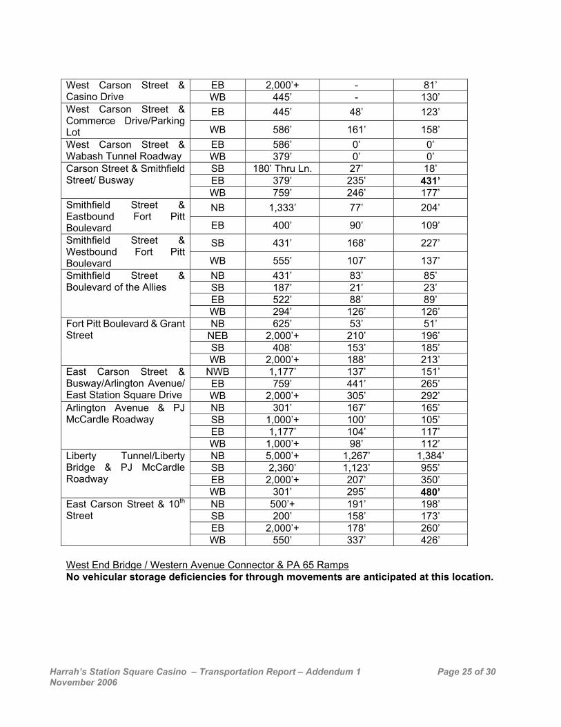
Harrah’s Station Square Casino – Transportation Report – Addendum 1 Page 25 of 30 November 2006
EB 2,000’+ - 81’ West Carson Street &
Casino Drive WB 445’ - 130’ EB 445’ 48’ 123’ West Carson Street &
Commerce Drive/Parking Lot WB 586’ 161’ 158’
EB 586’ 0’ 0’ West Carson Street & Wabash Tunnel Roadway WB 379’ 0’ 0’
SB 180’ Thru Ln. 27’ 18’ EB 379’ 235’ 431’
Carson Street & Smithfield Street/ Busway
WB 759’ 246’ 177’ NB 1,333’ 77’ 204’ Smithfield Street &
Eastbound Fort Pitt Boulevard EB 400’ 90’ 109’
SB 431’ 168’ 227’ Smithfield Street & Westbound Fort Pitt Boulevard WB 555’ 107’ 137’
NB 431’ 83’ 85’ SB 187’ 21’ 23’ EB 522’ 88’ 89’
Smithfield Street & Boulevard of the Allies
WB 294’ 126’ 126’ NB 625’ 53’ 51’
NEB 2,000’+ 210’ 196’ SB 408’ 153’ 185’
Fort Pitt Boulevard & Grant Street
WB 2,000’+ 188’ 213’ NWB 1,177’ 137’ 151’ EB 759’ 441’ 265’
East Carson Street & Busway/Arlington Avenue/ East Station Square Drive WB 2,000’+ 305’ 292’
NB 301’ 167’ 165’ SB 1,000’+ 100’ 105’ EB 1,177’ 104’ 117’
Arlington Avenue & PJ McCardle Roadway
WB 1,000’+ 98’ 112’ NB 5,000’+ 1,267’ 1,384’ SB 2,360’ 1,123’ 955’ EB 2,000’+ 207’ 350’
Liberty Tunnel/Liberty Bridge & PJ McCardle Roadway
WB 301’ 295’ 480’ NB 500’+ 191’ 198’ SB 200’ 158’ 173’ EB 2,000’+ 178’ 260’
East Carson Street & 10th Street
WB 550’ 337’ 426’ West End Bridge / Western Avenue Connector & PA 65 Ramps No vehicular storage deficiencies for through movements are anticipated at this location.
Harrah’s Station Square Casino – Transportation Report – Addendum 1 Page 26 of 30 November 2006
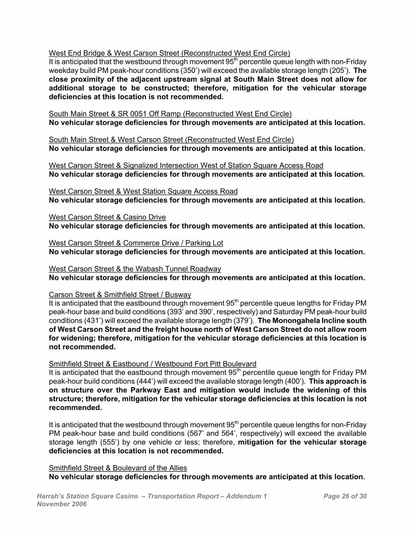
West End Bridge & West Carson Street (Reconstructed West End Circle) It is anticipated that the westbound through movement 95th percentile queue length with non-Friday weekday build PM peak-hour conditions (350’) will exceed the available storage length (205’). The close proximity of the adjacent upstream signal at South Main Street does not allow for additional storage to be constructed; therefore, mitigation for the vehicular storage deficiencies at this location is not recommended. South Main Street & SR 0051 Off Ramp (Reconstructed West End Circle) No vehicular storage deficiencies for through movements are anticipated at this location.
South Main Street & West Carson Street (Reconstructed West End Circle) No vehicular storage deficiencies for through movements are anticipated at this location. West Carson Street & Signalized Intersection West of Station Square Access Road No vehicular storage deficiencies for through movements are anticipated at this location. West Carson Street & West Station Square Access Road No vehicular storage deficiencies for through movements are anticipated at this location. West Carson Street & Casino Drive No vehicular storage deficiencies for through movements are anticipated at this location.
West Carson Street & Commerce Drive / Parking Lot No vehicular storage deficiencies for through movements are anticipated at this location. West Carson Street & the Wabash Tunnel Roadway No vehicular storage deficiencies for through movements are anticipated at this location. Carson Street & Smithfield Street / Busway It is anticipated that the eastbound through movement 95th percentile queue lengths for Friday PM peak-hour base and build conditions (393’ and 390’, respectively) and Saturday PM peak-hour build conditions (431’) will exceed the available storage length (379’). The Monongahela Incline south of West Carson Street and the freight house north of West Carson Street do not allow room for widening; therefore, mitigation for the vehicular storage deficiencies at this location is not recommended. Smithfield Street & Eastbound / Westbound Fort Pitt Boulevard It is anticipated that the eastbound through movement 95th percentile queue length for Friday PM peak-hour build conditions (444’) will exceed the available storage length (400’). This approach is on structure over the Parkway East and mitigation would include the widening of this structure; therefore, mitigation for the vehicular storage deficiencies at this location is not recommended. It is anticipated that the westbound through movement 95th percentile queue lengths for non-Friday PM peak-hour base and build conditions (567’ and 564’, respectively) will exceed the available storage length (555’) by one vehicle or less; therefore, mitigation for the vehicular storage deficiencies at this location is not recommended. Smithfield Street & Boulevard of the Allies No vehicular storage deficiencies for through movements are anticipated at this location.
Harrah’s Station Square Casino – Transportation Report – Addendum 1 Page 27 of 30 November 2006
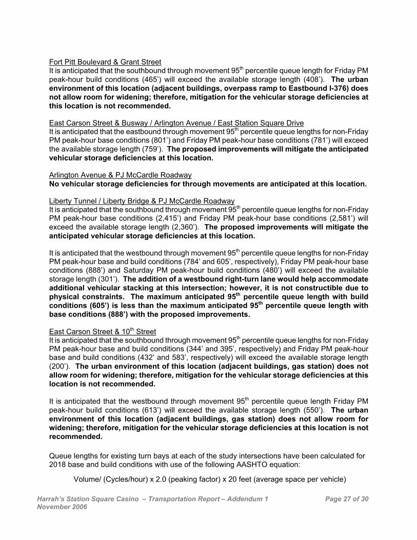
Fort Pitt Boulevard & Grant Street It is anticipated that the southbound through movement 95th percentile queue length for Friday PM peak-hour build conditions (465’) will exceed the available storage length (408’). The urban environment of this location (adjacent buildings, overpass ramp to Eastbound I-376) does not allow room for widening; therefore, mitigation for the vehicular storage deficiencies at this location is not recommended. East Carson Street & Busway / Arlington Avenue / East Station Square Drive It is anticipated that the eastbound through movement 95th percentile queue lengths for non-Friday PM peak-hour base conditions (801’) and Friday PM peak-hour base conditions (781’) will exceed the available storage length (759’). The proposed improvements will mitigate the anticipated vehicular storage deficiencies at this location. Arlington Avenue & PJ McCardle Roadway No vehicular storage deficiencies for through movements are anticipated at this location. Liberty Tunnel / Liberty Bridge & PJ McCardle Roadway It is anticipated that the southbound through movement 95th percentile queue lengths for non-Friday PM peak-hour base conditions (2,415’) and Friday PM peak-hour base conditions (2,581’) will exceed the available storage length (2,360’). The proposed improvements will mitigate the anticipated vehicular storage deficiencies at this location. It is anticipated that the westbound through movement 95th percentile queue lengths for non-Friday PM peak-hour base and build conditions (784’ and 605’, respectively), Friday PM peak-hour base conditions (888’) and Saturday PM peak-hour build conditions (480’) will exceed the available storage length (301’). The addition of a westbound right-turn lane would help accommodate additional vehicular stacking at this intersection; however, it is not constructible due to physical constraints. The maximum anticipated 95th percentile queue length with build conditions (605’) is less than the maximum anticipated 95th percentile queue length with base conditions (888’) with the proposed improvements. East Carson Street & 10th Street It is anticipated that the southbound through movement 95th percentile queue lengths for non-Friday PM peak-hour base and build conditions (344’ and 395’, respectively) and Friday PM peak-hour base and build conditions (432’ and 583’, respectively) will exceed the available storage length (200’). The urban environment of this location (adjacent buildings, gas station) does not allow room for widening; therefore, mitigation for the vehicular storage deficiencies at this location is not recommended. It is anticipated that the westbound through movement 95th percentile queue length Friday PM peak-hour build conditions (613’) will exceed the available storage length (550’). The urban environment of this location (adjacent buildings, gas station) does not allow room for widening; therefore, mitigation for the vehicular storage deficiencies at this location is not recommended. Queue lengths for existing turn bays at each of the study intersections have been calculated for 2018 base and build conditions with use of the following AASHTO equation:
Volume/ (Cycles/hour) x 2.0 (peaking factor) x 20 feet (average space per vehicle)
Harrah’s Station Square Casino – Transportation Report – Addendum 1 Page 28 of 30 November 2006
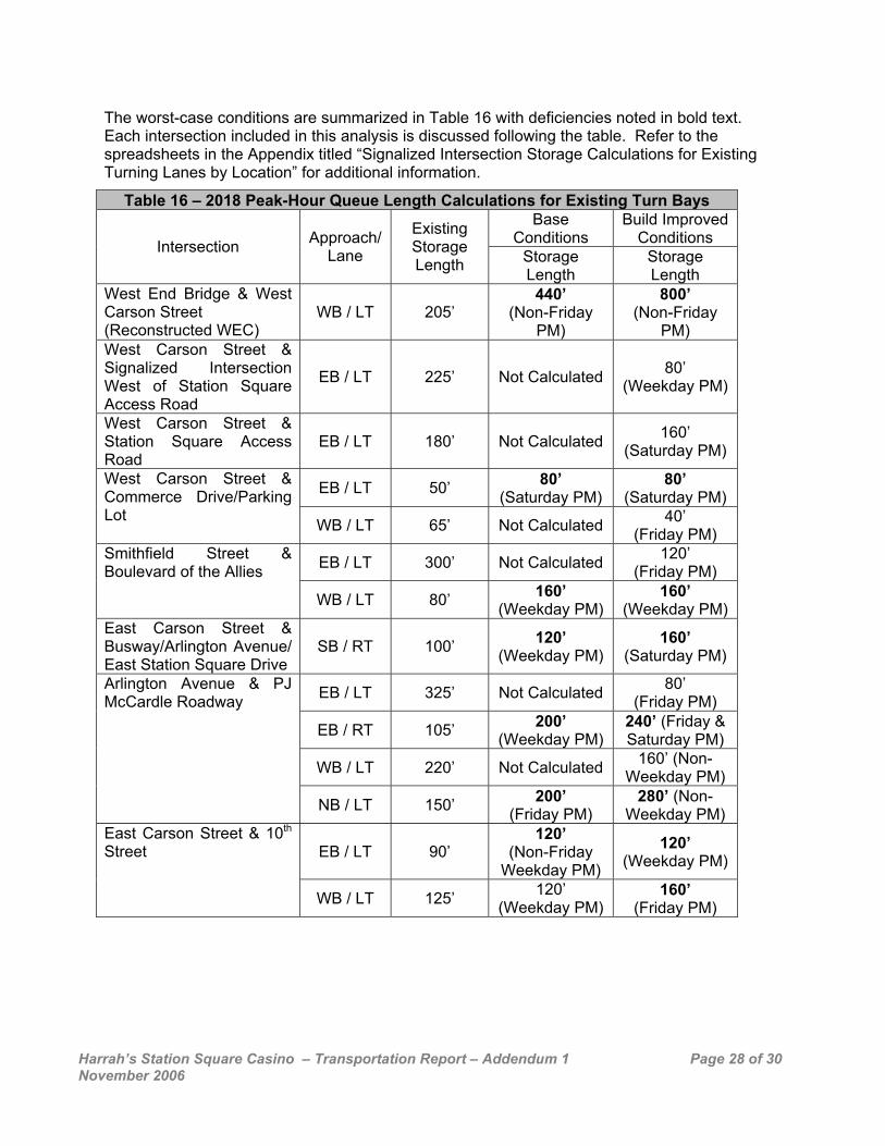
The worst-case conditions are summarized in Table 16 with deficiencies noted in bold text. Each intersection included in this analysis is discussed following the table. Refer to the spreadsheets in the Appendix titled “Signalized Intersection Storage Calculations for Existing Turning Lanes by Location” for additional information.
Table 16 – 2018 Peak-Hour Queue Length Calculations for Existing Turn Bays Base
Conditions Build Improved
Conditions Intersection Approach/ Lane
Existing Storage Length Storage
Length Storage Length
West End Bridge & West Carson Street (Reconstructed WEC)
WB / LT 205’ 440’
(Non-Friday PM)
800’ (Non-Friday
PM) West Carson Street & Signalized Intersection West of Station Square Access Road
EB / LT 225’ Not Calculated 80’ (Weekday PM)
West Carson Street & Station Square Access Road
EB / LT 180’ Not Calculated 160’ (Saturday PM)
EB / LT 50’ 80’ (Saturday PM)
80’ (Saturday PM)
West Carson Street & Commerce Drive/Parking Lot WB / LT 65’ Not Calculated 40’
(Friday PM)
EB / LT 300’ Not Calculated 120’ (Friday PM)
Smithfield Street & Boulevard of the Allies
WB / LT 80’ 160’ (Weekday PM)
160’ (Weekday PM)
East Carson Street & Busway/Arlington Avenue/ East Station Square Drive
SB / RT 100’ 120’ (Weekday PM)
160’ (Saturday PM)
EB / LT 325’ Not Calculated 80’ (Friday PM)
EB / RT 105’ 200’ (Weekday PM)
240’ (Friday & Saturday PM)
WB / LT 220’ Not Calculated 160’ (Non- Weekday PM)
Arlington Avenue & PJ McCardle Roadway
NB / LT 150’ 200’ (Friday PM)
280’ (Non- Weekday PM)
EB / LT 90’ 120’
(Non-Friday Weekday PM)
120’ (Weekday PM)
East Carson Street & 10th Street
WB / LT 125’ 120’ (Weekday PM)
160’ (Friday PM)
Harrah’s Station Square Casino – Transportation Report – Addendum 1 Page 29 of 30 November 2006
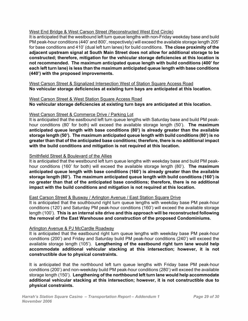
West End Bridge & West Carson Street (Reconstructed West End Circle) It is anticipated that the westbound left turn queue lengths with non-Friday weekday base and build PM peak-hour conditions (440’ and 800’, respectively) will exceed the available storage length 205’ for base conditions and 410’ (dual left turn lanes) for build conditions. The close proximity of the adjacent upstream signal at South Main Street does not allow for additional storage to be constructed; therefore, mitigation for the vehicular storage deficiencies at this location is not recommended. The maximum anticipated queue length with build conditions (400’ for each left turn lane) is less than the maximum anticipated queue length with base conditions (440’) with the proposed improvements. West Carson Street & Signalized Intersection West of Station Square Access Road No vehicular storage deficiencies at existing turn bays are anticipated at this location. West Carson Street & West Station Square Access Road No vehicular storage deficiencies at existing turn bays are anticipated at this location. West Carson Street & Commerce Drive / Parking Lot It is anticipated that the eastbound left turn queue lengths with Saturday base and build PM peak-hour conditions (80’ for both) will exceed the available storage length (50’). The maximum anticipated queue length with base conditions (80’) is already greater than the available storage length (50’). The maximum anticipated queue length with build conditions (80’) is no greater than that of the anticipated base conditions; therefore, there is no additional impact with the build conditions and mitigation is not required at this location. Smithfield Street & Boulevard of the Allies It is anticipated that the westbound left turn queue lengths with weekday base and build PM peak-hour conditions (160’ for both) will exceed the available storage length (80’). The maximum anticipated queue length with base conditions (160’) is already greater than the available storage length (80’). The maximum anticipated queue length with build conditions (160’) is no greater than that of the anticipated base conditions; therefore, there is no additional impact with the build conditions and mitigation is not required at this location. East Carson Street & Busway / Arlington Avenue / East Station Square Drive It is anticipated that the southbound right turn queue lengths with weekday base PM peak-hour conditions (120’) and Saturday PM peak-hour conditions (160’) will exceed the available storage length (100’). This is an internal site drive and this approach will be reconstructed following the removal of the East Warehouse and construction of the proposed Condominiums. Arlington Avenue & PJ McCardle Roadway It is anticipated that the eastbound right turn queue lengths with weekday base PM peak-hour conditions (200’) and Friday and Saturday build PM peak-hour conditions (240’) will exceed the available storage length (105’). Lengthening of the eastbound right turn lane would help accommodate additional vehicular stacking at this intersection; however, it is not constructible due to physical constraints. It is anticipated that the northbound left turn queue lengths with Friday base PM peak-hour conditions (200’) and non-weekday build PM peak-hour conditions (280’) will exceed the available storage length (150’). Lengthening of the northbound left turn lane would help accommodate additional vehicular stacking at this intersection; however, it is not constructible due to physical constraints.
Harrah’s Station Square Casino – Transportation Report – Addendum 1 Page 30 of 30 November 2006
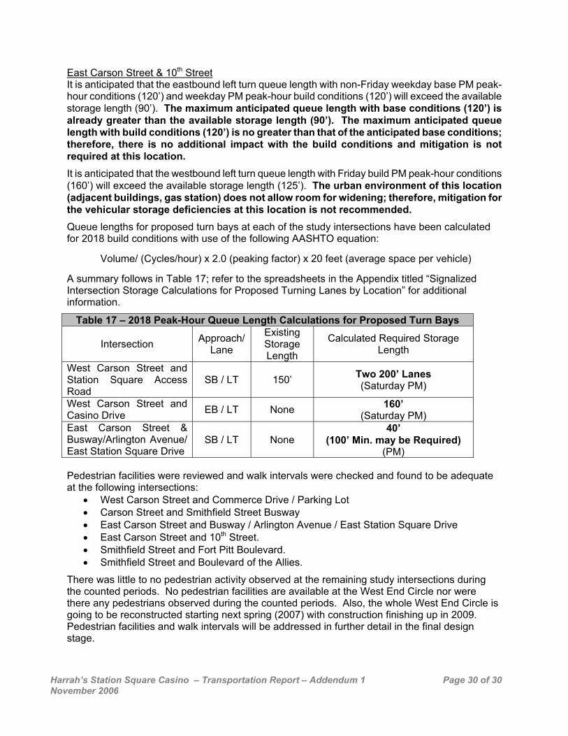
East Carson Street & 10th Street It is anticipated that the eastbound left turn queue length with non-Friday weekday base PM peak-hour conditions (120’) and weekday PM peak-hour build conditions (120’) will exceed the available storage length (90’). The maximum anticipated queue length with base conditions (120’) is already greater than the available storage length (90’). The maximum anticipated queue length with build conditions (120’) is no greater than that of the anticipated base conditions; therefore, there is no additional impact with the build conditions and mitigation is not required at this location. It is anticipated that the westbound left turn queue length with Friday build PM peak-hour conditions (160’) will exceed the available storage length (125’). The urban environment of this location (adjacent buildings, gas station) does not allow room for widening; therefore, mitigation for the vehicular storage deficiencies at this location is not recommended. Queue lengths for proposed turn bays at each of the study intersections have been calculated for 2018 build conditions with use of the following AASHTO equation:
Volume/ (Cycles/hour) x 2.0 (peaking factor) x 20 feet (average space per vehicle)
A summary follows in Table 17; refer to the spreadsheets in the Appendix titled “Signalized Intersection Storage Calculations for Proposed Turning Lanes by Location” for additional information.
Table 17 – 2018 Peak-Hour Queue Length Calculations for Proposed Turn Bays
Intersection Approach/ Lane
Existing Storage Length
Calculated Required Storage Length
West Carson Street and Station Square Access Road
SB / LT 150’ Two 200’ Lanes (Saturday PM)
West Carson Street and Casino Drive EB / LT None 160’
(Saturday PM) East Carson Street & Busway/Arlington Avenue/ East Station Square Drive
SB / LT None 40’
(100’ Min. may be Required) (PM)
Pedestrian facilities were reviewed and walk intervals were checked and found to be adequate at the following intersections:
• West Carson Street and Commerce Drive / Parking Lot • Carson Street and Smithfield Street Busway • East Carson Street and Busway / Arlington Avenue / East Station Square Drive • East Carson Street and 10th Street. • Smithfield Street and Fort Pitt Boulevard. • Smithfield Street and Boulevard of the Allies.
There was little to no pedestrian activity observed at the remaining study intersections during the counted periods. No pedestrian facilities are available at the West End Circle nor were there any pedestrians observed during the counted periods. Also, the whole West End Circle is going to be reconstructed starting next spring (2007) with construction finishing up in 2009. Pedestrian facilities and walk intervals will be addressed in further detail in the final design stage.