heritage resources inventory - oxford county > home resources inventory last updated: august 14,...
TRANSCRIPT
Heritage Resources Inventory Last Updated: August 14, 2006 Introduction The general policies of section 3.2.10, Cultural Heritage, in the Official Plan set out to encourage the preservation and enhancement of properties or areas of historic, architectural, archaeological and natural interest through the establishment and maintenance of a comprehensive data base listing of these properties. The Heritage Resources Inventory is intended to support these policies and will become an Appendix to the County Official Plan. The Heritage Resources Inventory, consists of six (6) categories: places of worship, cemeteries, historical/architectural resources, cultural resources, natural areas and parks, and plaques and monuments. The Inventory has been organized by area municipality. The categories Places of Worship and Cemeteries contain listings of all known religious congregations and cemeteries within the municipality. These properties are of historical and/or architectural interest. Schools constructed prior to 1950 and that are still functioning have been included in the Educational Institutions category of this inventory. A cut-off date of 1950 was chosen on the premise that schools constructed prior to this time are more likely to have some architectural significance. In the Historical/Architectural Resources category, only properties that have an official designation have been included. These designations are described below. The Cultural Resources category encompasses public institutions such as libraries, museums and art galleries. The category Natural Areas and Parks contains open spaces that are of historical interest and/or of significant size with a naturalized component. Only properties accessible to the public have been included. Throughout the Heritage Resources Inventory, a property on which a plaque is located is identified by the symbol ◙ and includes a description of its importance. If a plaque is not connected to a particular geographic location or structure in the Inventory, it has been included in the Plaques and Monuments category found at the end of each municipal section. A complete listing of plaques in the County of Oxford is available from the Oxford County Library website. Within the County of Oxford the following official designations may be assigned to a property: ‘Local’ indicates a property designated by the Local Architectural Conservancy Advisory Committee (LACAC). 'Provincial' indicates a property designated by the municipality through the Ontario Heritage Foundation (Ontario Heritage Act, part 4). ‘OHFP’ indicates that an Ontario Heritage Foundation Plaque has been allocated to a property. The 'National' designation indicates a National Historic Site. n/a indicates that the property has no known official designation.
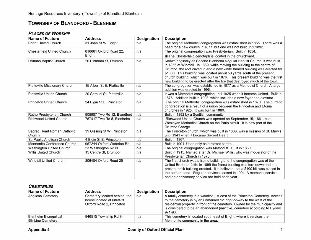
Heritage Resources Inventory ● Township of Blandford-Blenheim
Appendix 4 County of Oxford Official Plan 1
TOWNSHIP OF BLANDFORD - BLENHEIM PLACES OF WORSHIP Name of Feature Address Designation Description Bright United Church 31 John St W, Bright n/a The original Methodist congregation was established in 1865. There was a
need for a new church in 1877, but one was not built until 1892. Chesterfield United Church 816661 Oxford Road 22,
Bright n/a The original congregation was Presbyterian. Built in 1854.
◙ The Chesterfield cenotaph is located in the churchyard. Drumbo Baptist Church 20 Pinkham St, Drumbo n/a Known originally as Second Blenheim Regular Baptist Church, it was built
in 1855 at Windfall. In 1859, while moving the building to the centre of Drumbo, the roof caved in and a new white framed building was erected for $1000. This building was located about 50 yards south of the present church building, which was built in 1876. This present building was the first new building to be erected after the fire that destroyed much of the town.
Plattsville Missionary Church 15 Albert St E, Plattsville n/a The congregation was established in 1877 as a Methodist Church. A large addition was erected in 1996.
Plattsville United Church 20 Samuel St, Plattsville n/a It was a Methodist congregation until 1925 when it became United. Built in 1876. Addition built in 1993, which includes a new foyer and elevator.
Princeton United Church 24 Elgin St E, Princeton n/a The original Methodist congregation was established in 1870. The current congregation is a result of a union between the Princeton and Etonia churches in 1925. It was built in 1880.
Ratho Presbyterian Church 905987 Twp Rd 12, Blandford n/a Built in 1852 by a Scottish community. Richwood United Church 767417 Twp Rd 5, Blenheim n/a Richwood United Church was opened on September 15, 1861, as a
Wesleyan Methodist Church on the Paris circuit. It is now part of the Drumbo Charge.
Sacred Heart Roman Catholic Church
39 Gissing St W, Princeton n/a The Princeton church, which was built in 1888, was a mission of St. Mary’s until 1941 when it became Sacred Heart.
St. Paul’s Anglican Church 4 Elgin St E, Princeton n/a Built in 1867. Mennonite Conference Church 967244 Oxford-Waterloo Rd n/a Built in 1901. Used only as a retreat centre. Washington United Church 23 Washington Rd N n/a The original congregation was Methodist. Built in 1860. Willis United Church 15 Centre St, Drumbo n/a Built in 1915. Named after Dr. Michael Willis, who was moderator of the
Presbyterian Church in 1870. Windfall United Church 806484 Oxford Road 29 n/a The first church was a frame building and the congregation was of the
United Brethren faith. In 1899 the frame building was torn down and the present brick building erected. It is believed that a $100 bill was placed in the corner stone. Regular services ceased in 1991. A memorial service and an anniversary service are held each year.
CEMETERIES Name of Feature Address Designation Description Anglican Cemetery Cemetery located behind the
house located at 686879 Oxford Road 2, Princeton
n/a A family cemetery in a woodlot just east of the Princeton Cemetery. Access to the cemetery is by an unmarked 12’ right-of-way to the west of the residential property in front of the cemetery. Owned by the municipality and is considered to be an abandoned (inactive) cemetery according to By-law 971-93.
Blenheim Evangelical 9th Line Cemetery
846515 Township Rd 9 n/a This cemetery is located south east of Bright, where it services the Mennonite community in the area.
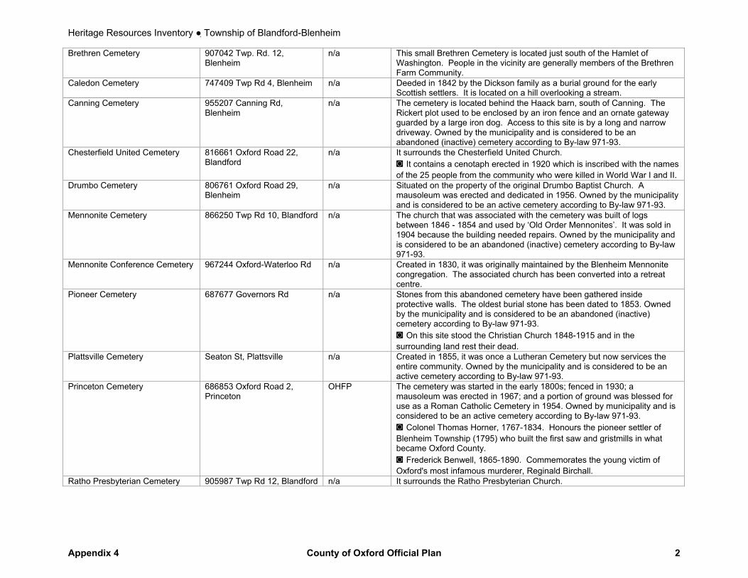
Heritage Resources Inventory ● Township of Blandford-Blenheim
Appendix 4 County of Oxford Official Plan 2
Brethren Cemetery 907042 Twp. Rd. 12, Blenheim
n/a This small Brethren Cemetery is located just south of the Hamlet of Washington. People in the vicinity are generally members of the Brethren Farm Community.
Caledon Cemetery 747409 Twp Rd 4, Blenheim n/a Deeded in 1842 by the Dickson family as a burial ground for the early Scottish settlers. It is located on a hill overlooking a stream.
Canning Cemetery 955207 Canning Rd, Blenheim
n/a The cemetery is located behind the Haack barn, south of Canning. The Rickert plot used to be enclosed by an iron fence and an ornate gateway guarded by a large iron dog. Access to this site is by a long and narrow driveway. Owned by the municipality and is considered to be an abandoned (inactive) cemetery according to By-law 971-93.
Chesterfield United Cemetery 816661 Oxford Road 22, Blandford
n/a It surrounds the Chesterfield United Church. ◙ It contains a cenotaph erected in 1920 which is inscribed with the names of the 25 people from the community who were killed in World War I and II.
Drumbo Cemetery 806761 Oxford Road 29, Blenheim
n/a Situated on the property of the original Drumbo Baptist Church. A mausoleum was erected and dedicated in 1956. Owned by the municipality and is considered to be an active cemetery according to By-law 971-93.
Mennonite Cemetery 866250 Twp Rd 10, Blandford n/a The church that was associated with the cemetery was built of logs between 1846 - 1854 and used by ‘Old Order Mennonites’. It was sold in 1904 because the building needed repairs. Owned by the municipality and is considered to be an abandoned (inactive) cemetery according to By-law 971-93.
Mennonite Conference Cemetery 967244 Oxford-Waterloo Rd n/a Created in 1830, it was originally maintained by the Blenheim Mennonite congregation. The associated church has been converted into a retreat centre.
Pioneer Cemetery 687677 Governors Rd n/a Stones from this abandoned cemetery have been gathered inside protective walls. The oldest burial stone has been dated to 1853. Owned by the municipality and is considered to be an abandoned (inactive) cemetery according to By-law 971-93. ◙ On this site stood the Christian Church 1848-1915 and in the surrounding land rest their dead.
Plattsville Cemetery Seaton St, Plattsville n/a Created in 1855, it was once a Lutheran Cemetery but now services the entire community. Owned by the municipality and is considered to be an active cemetery according to By-law 971-93.
Princeton Cemetery 686853 Oxford Road 2, Princeton
OHFP The cemetery was started in the early 1800s; fenced in 1930; a mausoleum was erected in 1967; and a portion of ground was blessed for use as a Roman Catholic Cemetery in 1954. Owned by municipality and is considered to be an active cemetery according to By-law 971-93. ◙ Colonel Thomas Horner, 1767-1834. Honours the pioneer settler of Blenheim Township (1795) who built the first saw and gristmills in what became Oxford County. ◙ Frederick Benwell, 1865-1890. Commemorates the young victim of Oxford's most infamous murderer, Reginald Birchall.
Ratho Presbyterian Cemetery 905987 Twp Rd 12, Blandford n/a It surrounds the Ratho Presbyterian Church.
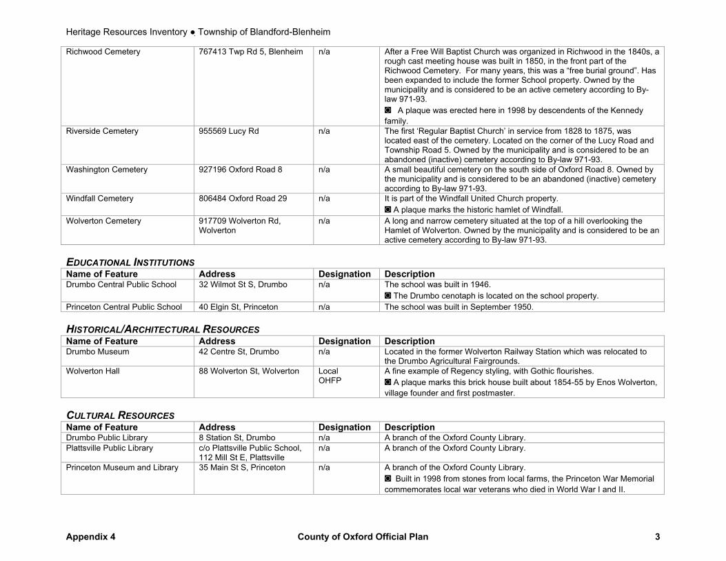
Heritage Resources Inventory ● Township of Blandford-Blenheim
Appendix 4 County of Oxford Official Plan 3
Richwood Cemetery 767413 Twp Rd 5, Blenheim n/a After a Free Will Baptist Church was organized in Richwood in the 1840s, a rough cast meeting house was built in 1850, in the front part of the Richwood Cemetery. For many years, this was a “free burial ground”. Has been expanded to include the former School property. Owned by the municipality and is considered to be an active cemetery according to By-law 971-93. ◙ A plaque was erected here in 1998 by descendents of the Kennedy family.
Riverside Cemetery 955569 Lucy Rd n/a The first ‘Regular Baptist Church’ in service from 1828 to 1875, was located east of the cemetery. Located on the corner of the Lucy Road and Township Road 5. Owned by the municipality and is considered to be an abandoned (inactive) cemetery according to By-law 971-93.
Washington Cemetery 927196 Oxford Road 8 n/a A small beautiful cemetery on the south side of Oxford Road 8. Owned by the municipality and is considered to be an abandoned (inactive) cemetery according to By-law 971-93.
Windfall Cemetery 806484 Oxford Road 29 n/a It is part of the Windfall United Church property. ◙ A plaque marks the historic hamlet of Windfall.
Wolverton Cemetery 917709 Wolverton Rd, Wolverton
n/a A long and narrow cemetery situated at the top of a hill overlooking the Hamlet of Wolverton. Owned by the municipality and is considered to be an active cemetery according to By-law 971-93.
EDUCATIONAL INSTITUTIONS Name of Feature Address Designation Description Drumbo Central Public School 32 Wilmot St S, Drumbo n/a The school was built in 1946.
◙ The Drumbo cenotaph is located on the school property. Princeton Central Public School 40 Elgin St, Princeton n/a The school was built in September 1950. HISTORICAL/ARCHITECTURAL RESOURCES Name of Feature Address Designation Description Drumbo Museum 42 Centre St, Drumbo n/a Located in the former Wolverton Railway Station which was relocated to
the Drumbo Agricultural Fairgrounds. Wolverton Hall 88 Wolverton St, Wolverton Local
OHFP A fine example of Regency styling, with Gothic flourishes. ◙ A plaque marks this brick house built about 1854-55 by Enos Wolverton, village founder and first postmaster.
CULTURAL RESOURCES Name of Feature Address Designation Description Drumbo Public Library 8 Station St, Drumbo n/a A branch of the Oxford County Library. Plattsville Public Library c/o Plattsville Public School,
112 Mill St E, Plattsville n/a A branch of the Oxford County Library.
Princeton Museum and Library 35 Main St S, Princeton
n/a A branch of the Oxford County Library. ◙ Built in 1998 from stones from local farms, the Princeton War Memorial commemorates local war veterans who died in World War I and II.

Heritage Resources Inventory ● Township of Blandford-Blenheim
Appendix 4 County of Oxford Official Plan 4
Richwood Community Centre 767415 Twp Rd 5, Blenheim n/a Originally a two-room schoolhouse, the former S.S. No. 14 was operated as a school from 1857 to 1963. The building is now owned by the Municipality of Blandford-Blenheim and is used as a community centre.
NATURAL AREAS AND PARKS Name of Feature Address Designation Description Chesney Wilderness Con 9 lot 5 Blandford n/a This 40.5 ha (100 aces) of land was the first reforestation plot in the
County in 1944. Similar tracts were established in Drumbo, Centreville, Innerkip, Embro and Lakeside.
Plattsville Memorial Community Arena and Park
68 Mill St E, Plattsville n/a Park offers 1 ball diamond with field lights, arena. There is also a pavilion. The “To Our Heroes” Memorial Gate was set up in August 1921 in honour of the men and women who served in World War I. ◙ Plattsville cenotaph is located on the property.
Princeton Memorial Park 35 Main St S, Princeton n/a ◙ A cairn and flagpole in honour of Mac McAnsh, a gentleman who operated the hardware in Princeton for many years is located in front of the Centennial Building.
PLAQUES AND MONUMENTS Name of Feature Address Designation Description Blandford School 775903 Blandford Rd n/a ◙ Dedicated to all Schools in the former Township of Blandford. Drumbo Agricultural Society 42 Centre St, Drumbo n/a ◙There are two plaques on the property commemorating 100 years
of the Drumbo Fair and 150 years of the Drumbo Fair, respectively. Henry Muma, 1822 – 1902 12 Wilmot St N, Drumbo n/a ◙ Land agent and founder of Drumbo post office in 1854; he began a
brick works here in 1874 and founded the Muma Block on this corner in 1890. His photograph is in the village agricultural hall.
Mudge Hollow Canning n/a ◙ Located on Township Road 3 east of the Canning Road, Canning was originally known as Mudge Hollow.

Heritage Resources Inventory ● Township of East Zorra-Tavistock
Appendix 4 County of Oxford Official Plan 5
TOWNSHIP OF EAST ZORRA – TAVISTOCK PLACES OF WORSHIP Name of Feature Address Designation Description Cassell Mennonite Church 696556 17th Line n/a The congregation was established in 1935. Christ Church 595815 Oxford Road 59 N,
Huntingford n/a The congregation was established in 1839 when a frame building was
erected. The current church was built in 1950. East Zorra Mennonite (Amish) Church
677044 16th Line n/a The congregation was established in 1837.
Grace United Church 42 William St, Tavistock n/a The original congregation was established in the 1840s. The current church was built in 1904. The congregations from Zion and South Easthope Churches, Knox United Church and Harmony United Church united in 1969.
Hebron United Church 676241 16th Line n/a The congregation was established in 1843 and the current church was built in 1899.
Hickson United Church 596243 Highway 59, Hickson n/a It opened in 1902 as a Wesleyan Methodist Church and joined the United Church in 1925.
Innerkip Presbyterian Church 153 Blandford St, Innerkip n/a The congregation was established in 1852. The newest church opened in 1881.
Innerkip United Church 11-13 Vincent St, Innerkip n/a Worship meetings of this Methodist congregation began in 1882 and a new brick church opened in 1887. It joined the United Church in 1925.
South Zorra Baptist Church 615433 13th Line n/a It was established and built in 1870. St. Matthews Lutheran Church 965565 Maplewood Sideroad n/a Services began in 1852, and the current church was built in 1866. It is the
oldest Lutheran church in East Zorra. St. Paul’s Evangelical Lutheran Church
17 Wellington St, Tavistock n/a Dedicated in December 1882.
Tavistock Bible Chapel 32 Oxford St, Tavistock n/a Built in 1880. Tavistock Mennonite Church 129 Wettlaufer , Tavistock n/a Built in 1942. Trinity Anglican Church 596682 Oxford Road 59 n/a Consecrated on June 14, 1861. It closed in 1967, but a minister from the
Church of the Good Shepherd holds a service in the old church once a year.
CEMETERIES Name of Feature Address Designation Description Amish Mennonite Cemetery 985992 Perth-Oxford Rd n/a This cemetery was opened before the East Zorra Mennonite Cemetery,
ca. 1840s. The stones have been moved to one end of the cemetery. East Zorra Baptist Cemetery 924947 Cassell Sideroad
n/a The earliest burial recorded was in 1853.
East Zorra Mennonite Cemetery 677044 16th Line n/a The congregation was established in the 1850s. There is a church beside the cemetery.
East Zorra Municipal (Brickyard) Cemetery
656981 15th Line n/a The adjoining farm owners donated this cemetery in 1857. The only burials being made there now are from the People Care Centre in Tavistock when there are no relatives to claim the deceased.
Grace United Cemetery 42 William St, Tavistock n/a Associated with Grace United Church in Tavistock. Huntingford Anglican Cemetery 595815 Oxford Road 59 n/a The church (Christ Church) associated with the cemetery was built in
1839.
Heritage Resources Inventory ● Township of East Zorra-Tavistock
Appendix 4 County of Oxford Official Plan 6
Innerkip Cemetery Main St / James St, Innerkip n/a It was transferred from a private family cemetery to the Innerkip Cemetery Company for use by the community in 1873.
New Evangelical United Brethren Cemetery
696556 17th Line n/a The New cemetery was opened when the old church burned down and a new one was built. There are some burials from Hebron United Church on the south side of the cemetery.
Old Evangelical United Brethren Cemetery
696854 17th Line n/a This cemetery was opened in 1858. In the 1940s, slabs and markers were laid flat and enclosed with a fence.
St. Matthew’s Lutheran Cemetery 965565 Maplewood Sideroad n/a Associated with St. Matthew’s Lutheran Church, which was built in 1866. Burial records date to the 1850s.
St. Paul’s Evangelical Lutheran Roth St, Tavistock n/a A half-acre was made available for cemetery use at the Grand Trunk Railway tracts in 1882.
Trinity Anglican Cemetery 596682 Oxford Road 59 n/a Consecrated at the same time as the church on June 14, 1861; however, the first burial was in 1849.
Vandecar Cemetery 515887 11th Line n/a A pioneer cemetery, its earliest burial was in 1848. Many of the older tombstones have been placed in a central cairn.
EDUCATIONAL INSTITUTIONS Name of Feature Address Designation Description Innerkip Central P.S. 180 Coleman St, Innerkip n/a The original school which was originally built in 1930 has since been
replaced with a more modern facility. Tollgate Central P.S. 744993 Oxford Road 17 n/a It was originally called S.S. No. 4 and was built on this site in 1848. A
more modern facility has since been built (1954). HISTORICAL/ARCHITECTURAL RESOURCES Name of Feature Address Designation Description The Glass Swan 52 Woodstock St S, Tavistock Local ◙ There is a plaque commemorating the historic house from Tavistock's
earliest days. CULTURAL RESOURCES Name of Feature Address Designation Description Hickson Public Library 85 Loveys St, Hickson n/a A branch of the Oxford County Library. Innerkip Public Library 695566 Oxford Road 5,
Innerkip n/a A branch of the Oxford County Library.
Tavistock Public Library 35 Maria St, Tavistock n/a A branch of the Oxford County Library. NATURAL AREAS AND PARKS Name of Feature Address Designation Description Innerkip Lions Park 695566 Oxford Road 5,
Innerkip n/a 6.9 ha (17 acres).
Optimist Club of Tavistock Park 250 Oxford Road 59, Tavistock
n/a 4.5 ha (11 acres).
Tavistock Queens Park Maria St n/a Established in 1928. The stone gates were funded by the local Women’s Auxiliary. 20.5 ha (50 acres) of parkland and facilities.
W. Leslie Dickson Arboretum 715570 Oxford Road 4 n/a Dedicated to the memory of W.L. Dickson. This little 6 ha (20 acres) jewel is a product of a group called "The Men of the Trees". They have worked very hard to provide in excess of 150 labeled native trees and shrubs.
Heritage Resources Inventory ● Township of East Zorra-Tavistock
Appendix 4 County of Oxford Official Plan 7
PLAQUES AND MONUMENTS Name of Feature Address Designation Description Canada's Birthday 986044 Perth-Oxford Rd n/a ◙ Located at Punkeydoodle’s Corners. A 6-sided concrete pillar with the
inscription "Canada's Birthday 1982." It commemorates the Rt. Honourable Joe Clark’s visit to the community on this day.
David Stock Caister’s Tavern
597112 Oxford Road 59, Tavistock
n/a ◙ Caister's Tavern ca.1845-1854. Caleb Caister came from England to Oxford County in 1833. In 1836 he settled on this site, cleared farmland and built a one-storey log dwelling. This dwelling was his family home but also served as an inn and tavern. Until 1848, when what is now Tavistock was established, Caister's home was the only public accommodation in north-central Oxford County for pioneers moving along the Huron Road and thence southerly into the Zorra settlement. By the 1840's Caister held an official municipal licence, and a survey map of the time shows that his log dwelling was known in this locality as Caister's Tavern.
Founder of Tavistock 22 Woodstock St S, Tavistock n/a ◙ A stone cairn erected 1930 in memory of Captain Henry Eckstein, founder of Tavistock, A.D. 1848. Rededicated 1948.
A Tribute to Farm Women OMAFRA site - Outdoor farm show?
n/a ◙This monument represents the role of farm women in the foundation and progress of Canadian Agriculture. Women from across the nation brought stones from their farms to help build this structure, erected throughout the three days of Canada’s Outdoor Farm Show, September 2000. Presented by Farm Credit Corporation, Canada’s Outdoor Farm Show, Ontario Farm Women’s Network.

Heritage Resources Inventory ● Township of Norwich
Appendix 4 County of Oxford Official Plan 8
TOWNSHIP OF NORWICH PLACES OF WORSHIP Name of Feature Address Designation Description Burgessville Baptist Church 0 Church St. W, Burgessville n/a Built in the 1870s. Burgessville Gospel Hall 610 Main St, Burgessville n/a Built in 1985. Burgessville United Church 0 Church St, Burgessville n/a It was a Methodist Church until 1925. Built in 1899. Christ Church (Anglican) 505395 Old Stage Rd, Oxford
Centre n/a Destroyed by a tornado in 1979, but was eventually re-erected.
Curries United Church 465003 Curries Rd, Curries
Provincial It was founded in 1855 as a Wesleyan Methodist Church, at which time it was named Zion Church; built in 1891.
Eastwood United Church 565739 Towerline Rd n/a It was established in 1866 as a Methodist Church and joined the United Church in 1925. Built in 1880.
Heritage Netherlands Reformed Congregation
685 Main St S, Burgessville n/a Built in 1996.
Knox Presbyterian Church 67 Main St W, Norwich Local Provincial
Services began in 1848 and a church was built in 1851 on John St. The present church was built in 1879.
Maple Dell Amish Church 265005 Maple Dell Rd n/a Built in 1879 as USS #14 and #4, Maple Dell School. An Amish School is also located on the site of this church.
Muir United Church 814575 Muir Line n/a Built in 1862 and rebuilt in 1910, St. Andrew’s the Church celebrated its Centennial in 1962. It was closed on June 26, 1988 and is now a private residence.
Newark United Church 593199 Oxford Road 13
n/a It was established as a Episcopal Methodist congregation in 1867. Although located adjacent to it, the Church does not own the Newark Community Cemetery. The current church building was erected in 1955.
Norwich Gore United Church 813186 Base Line Local Provincial
This white frame church was constructed of solid timbers in 1861. Its unique Regency design features large Gothic-style lancet windows which allow light to flood into the interior nave. ◙ There is a small plaque on the front door that states “Designated property, Ontario Heritage Act”.
Norwich United Church 80 Main St W, Norwich Local Provincial
In 1820, Michael Stover gave this land for a frame meeting house, to be used by all denominations until they had their own buildings. Built in 1885.
Norwich Village Regular Baptist Church
5 Elgin St, Norwich n/a Built in 1877.
Otterville Baptist Church 106 John St N, Otterville n/a Built in 1904. Otterville United Church 231 Main St E, Otterville n/a The original congregation was Methodist. Built in 1884. Oxford Centre United Church 714581 Middletown Line n/a The original part of the church was built in 1860. During the 1979
Tornado the entire roof was torn off the building, without damaging a single stained glass window.
Reformed Congregation in North America
284793 Pleasant Valley Rd Municipal Inventory
This was formerly St. Peter's Roman Catholic Church. A log church was built in the 1840s and the present brick church was erected in 1894.
Rehoboth Christian Reformed Church
43 Main St, Norwich n/a Built in 1968. Previously, the congregation had worshipped in the Cook mansion on Elgin Street.
Springford Baptist Church 422 Main St W, Springford n/a Built in 1887. Springford Reformed Church 308 Church St, Springford n/a Built in 1959.
Heritage Resources Inventory ● Township of Norwich
Appendix 4 County of Oxford Official Plan 9
Springford United Church 405 Main St E, Springford n/a It was established as a Methodist Church in 1858 and joined the United Church in 1925. Built in 1894.
St. John’s Anglican Church 23 Dover Street, Otterville
n/a The property for the present St. John’s Anglican Church was purchased in 1908 and a new church was built on the site.
St. John’s Anglican Church, Eastwood
685860 Oxford Road 2 n/a In 1836 Admiral Henry VanSittart gave land for a church and burying ground in Eastwood Village.
CEMETERIES Name of Feature Address Designation Description African Methodist Episcopal Cemetery
North of Otterville n/a Located north of the village, a cairn in this cemetery commemorates the early Black settlement of the area in 1829. ◙ There is a plaque to commemorate the Black Settlement of freed families who made their homes in this area.
Burgessville Baptist Cemetery Church St W, Burgessville n/a It was established in 1837 and the first burial was in 1846. Christ Church Anglican Cemetery 505395 Old Stage Rd, Oxford
Centre n/a Located north of Old Stage Road, this cemetery was originally built behind
Christ Church in Oxford Centre. Erbtown Cemetery (Free Methodist Cemetery)
225424 Main St W, Otterville n/a The Erb family donated the land prior to 1861 for the Episcopal Methodist Church and Cemetery.
Maple Dell Mennonite Cemetery 592948 Oxford Road 13 n/a The first Amish Mennonite family moved to the Norwich area in 1954. The first burial was made in 1959.
Milldale Burial Grounds 772754 Oxford Road 59 n/a The earliest burial was in 1873. This was a Friends’ Burying Ground. New Durham Cemetery 389105 New Durham Rd n/a The cemetery is not rectangular in shape, rather the boundaries follow the
contour of the land. The earliest burial was in 1847. There is a monument as a memorial to war army victims (1919).
New Road United Cemetery 164777 New Rd n/a The earliest burial was in 1861. Newark Community Cemetery 593189 Oxford Road 13 n/a It is next to the Newark United Church, but it is not the property of the
Church and the Church is not responsible for its upkeep. The first burial was in 1823 (present before land was given for the cemetery) and the last was in 1950. In 1963 the gravestones and monuments were covered over and a memorial stone was erected beside the Newark Church.
Nichols Family Cemetery Con 3 Lot 13, North Norwich n/a Private family plot for the David Nichols family. The records had been kept in a family teapot.
North Norwich Pioneer Cemetery (Tompkin’s Burying Ground)
345705 Quaker St n/a The earliest burial was in 1816. Many of the early settlers of the Township are buried here. ◙ The Norwich Quaker Settlement (Archaeological and Historical Sites Board of Ontario). In 1809, Peter Lossing, a member of the Society of Friends from Dutchess Co., New York, visited Norwich Township, and in June 1810, with his brother in-law Peter DeLong purchased 15,000 acres of land in this area. That fall Lossing brought his family to Upper Canada and early in 1811 settled on this lot. The DeLong family and nine others, principally from Dutchess County, joined Lossing the same year and by 1820 an additional group of about fifty had settled within the tract. Many were Quakers, and a frame meeting house, planed in 1812, was erected here in 1817. These resourceful pioneers founded one of the most successful Quaker communities in Upper Canada. ◙ There is a list of Norwich families in the settlement.
Heritage Resources Inventory ● Township of Norwich
Appendix 4 County of Oxford Official Plan 10
Norwich Gore Cemetery 813303 Base Line n/a The earliest burial was in 1818. This little cemetery is independent of Norwich Gore United Church.
Norwich Village Cemetery Avery’s Lane, Norwich
n/a The village’s cemetery was located behind the home of Mr. Hilliker, whose son was the first death of the village in 1824.
Old Reformed (Burgessville) Cemetery
Church St W, Burgessville (385296 Oxford Road 59)
n/a Adjacent to Burgessville Baptist Cemetery, it was established in 1970 by a group of local residents who came from the Netherlands.
Oriel Pioneer (East Cemetery) 734162 Oriel Line n/a This was originally the burial ground for the congregation of the Methodist Episcopal Church.
Oriel Sideroad (West Cemetery) 734159 Oriel Line n/a Registered in the 1860s to the Congregational Methodist Church. With the union of two churches, the Oriel cemeteries were disused and taken over by the Township of East Oxford as a municipal responsibility.
Otterville Cemetery 732634 Pick Line n/a The Otter Cemetery Company was formed in 1892 and it purchased land adjoining St. John’s Cemetery, on a high point overlooking Otterville.
Oxford Centre Pioneer Cemetery 505395 Old Stage Rd, Oxford Centre
n/a This cemetery is located north of Old Stage Road, tucked right in beside the Anglican cemetery in Oxford Centre. ◙ There is a memorial plaque in the circle driveway which is dedicated to “Our Heroes”, those who were killed in World War I and II.
Oxford Centre United Cemetery 714581 Middletown Rd n/a The earliest burial was in 1862. It is located beside the Oxford Centre United Church.
Pine Street Burying Ground 365 Main St, Otterville n/a This cemetery is landlocked. This was a Friends’ Burying Ground. Many of the earlier graves were marked with plain stones or stones with initials only.
Pleasant View Cemetery (Curries Cemetery)
465007 Curries Rd n/a The earliest burial was in 1848. Originally, the cemetery was called Zion, but in 1899 it was changed to Pleasant View.
Quaker Street Friends Cemetery (Old Brick) (C.G. Walker Memorial Gardens)
345705 Quaker St OHFP In 1949, the Old Brick meeting House was removed and part of the proceeds used to erect the stone gate posts, on one of which is a bronze plaque commemorating the ‘Old Brick’, and the aluminum fence which encloses the churchyard, a cairn, the original burial ground and an added section. ◙ On the gatepost is a plaque In commemoration of the “Old Brick” Meeting House that was erected in 1850 and removed in 1948. These posts were erected by Norwich Monthly Meeting of the Religious Society of Friends, September 1952. ◙ Quaker Street Public School S.S. No. 6, North Norwich (Lot 9, Con 3) 1883-1961. This school was located approximately one half mile (0.8 km) west of this memorial. The single roomed building, with basement and belfry, had a state roof and was constructed of locally made white brick. From about 1900 the school was heated by a wood burning basement furnace. For 50 years, a well and hand pump in the school yard was the water system. Coal oil lamps were replace by electric lights in 1922. All eight grades of the school were taught by one teacher. This school was an important part of the community. Three trustees elected by the local ratepayers administered the school business until 1944. About forty teachers served here and 1000 children in three generations attended this school. This memorial was erected by the Quaker Street School reunion Committed in 1988 in cooperation with the Ministry of Culture and Communications.
Rosanna Cemetery 145199 Potters Rd n/a The earliest burial was in 1889.
Heritage Resources Inventory ● Township of Norwich
Appendix 4 County of Oxford Official Plan 11
Springford Cemetery 225227 Springford Rd n/a Stone markers date back to 1826, but burials were known to have taken place prior to that. It was known as ‘Fox’s Burying Ground’. The first cemetery in the Township, it was taken over by the community in 1887.
St. John’s Anglican Cemetery 235 Church St, Otterville n/a The land was deeded in 1850 for a church and burying ground. It is located beside the Otterville Cemetery.
St. John’s Anglican, Eastwood 685860 Oxford Road 2 n/a The first burial was in 1856. The cemetery surrounds the church on three sides.
St. Peter’s Roman Catholic Cemetery
284793 Pleasant Valley Rd n/a This Roman Catholic cemetery is beside the former St. Peter’s Church in Newark. The church building was later purchased by a Dutch congregation.
Summerville Cemetery 774484 Oxford Road 14 OHFP About all that remains of the once thriving community of Summerville is a small cemetery on a hill. Stones were placed in two rows in 1967 and the ground releveled. ◙ There is a plaque depicting the story of Canada's first woman doctor and ardent suffragist and social reformer, Dr. Emily Howard Jennings Stowe, M.D., 1831-1903 in the cemetery which is near her birthplace. There is an identical plaque in front of Norwich & District Archives (Norwich Village).
Vandecar Cemetery 505912 Old Stage Rd n/a This was a Wesleyan Methodist cemetery located beside the Vandecar Wesleyan Methodist Church. The church property was sold in the early 1900s and later the stones were removed and the soil plowed.
Waggoner Cemetery (Zenda) n/a This small neglected cemetery was used for only the short period of 1826-1883. Many of those buried here are members of the Waggoner family.
EDUCATIONAL INSTITUTIONS Name of Feature Address Designation Description East Oxford P.S. 505767 Old Stage Rd OHFP ◙ A plaque commemorates Old Stage Road. Governor Simcoe inherited
this Indian trail known as the Detroit Path. Both American and British troops used it during the War of 1812 travelling between Detroit and Ancaster. Sections of the trail can still be travelled in East and West Oxford.
Norwich District High School Stover St S (Oxford Road 59), Norwich
n/a Built in 1952. ◙ Norwich Cenotaph: "Weeping Lady". This monument typifies the Quaker response of pacifism and the futility of war.
Norwich P.S. 12 Washington St, Norwich n/a Originally built in 1896 but replaced in 1973. Otterville P.S. 318 Main St W, Otterville n/a The façade is all that remains of the original 1927 building. However,
there is a plaque with the old school bell at the front of the school. HISTORICAL/ARCHITECTURAL RESOURCES Name of Feature Address Designation Description Big Otter Creek Bridge lot 14, con 10, Middletown
Line, South of Cornell Local, Provincial, Ontario Heritage Bridge List
One of the few remaining examples of pony truss steel bridge construction and is among the first of its kind built in Ontario (1900).
Heritage Resources Inventory ● Township of Norwich
Appendix 4 County of Oxford Official Plan 12
David Start House 465141 Curries Rd Local This Carpenter Gothic style of farmhouse was built in the 1870s by George Start. The cream bricks from which it is constructed were made at Close’s brickyard, east of Woodstock. Although there have been some additions, the four-paned windows, wooden shutters, gable gingerbread, and transomed and sidelighted front door are original to the house.
Emigh / Stam House, Holbrook 593806 Oxford Road 59 Local Provincial
Built in 1876, this white brick one and a half storey house has beautiful gable decorations, or gingerbread. Also of note are the flower keystones over the windows. Inside, the hall ceiling has molded plaster decorations in lily and rose design, while the kitchen has a tin ceiling and the original wainscoting.
The Freeman House 23 Main St E, Norwich Provincial The plan of this elegant two and a half storey house is rectangular, with exterior walls of white clay brick laid in a garden wall design and with a natural cut stone foundation. A wooden frieze below the eaves adds an extra touch of refinement below the low gable roof. This house was originally built in the 1880s for Rev. James Bidwell Freeman.
Hall / Munro House 9 Cook St, Norwich Local Provincial
Built in 1885. This building is an example of the many lofty- ceilinged, Italianate white brick structures built in the Village of Norwich in the 1880s. The centre doorway is enhanced by frosted sidelights and frosted panels in the door. Window and door surrounds echo the rounded shapes of openings and complement the elaborate brickwork and oval molded panels under the eaves.
Hawtrey Store 812227 Baseline Rd Local Provincial
Built in 1875, this French renaissance style building with its unique mansard roof originally had a roof walk with turned balusters and two double chimneys. The hooded dormers feature an elaborate scroll design under the eves. Originally known as Southwick’s Store, this building is now a private residence.
Imrie / Gilvesy House 144760 Potters Rd Local Provincial
This Italianate home was built in 1882 for Scottish immigrant James Imrie. The Scotch thistle keystones in the relating voussoirs of the windows and doors of “Haddon Hall’ attest to his pride of heritage. The Gilvesy family built the sympathetic addition and have carefully conducted authentic restoration of the original portion of the house.
Innis House – Innisfree Farm Local Provincial OHFP
◙ A plaque commemorates one of Canada's outstanding economic historians at his birthplace, Harold Adam Innis, 1894-1952. One of his students was Marshall McLuhan.
Moore / Chambers House (Avonmore)
8 Main St E, Norwich Local Provincial
This castle-like yellow brick house of historical and architectural significance was built in a gracious gothic style with exceptional detail in the design of the brickwork. Above, a widow’s walk of turned spindles tops the slate roof The open porch with its battlements and rounded arches was added several years after the house was built in 1876.
Nix / Freeman House 25 Main St W, Norwich Local This two and a half storey house sits majestically in a beautifully landscaped yard. Of note are the natural cut stone foundation and the white clay brick walls laid in a garden wall design. A wooden frieze runs below the eaves, complementing the simple beauty of the wall design of this 1880s house.
Norwich United Church manse 78 Main St W, Norwich
Local Provincial
Built of local brick in 1875, this Italianate-style house complements the adjacent church.
Otterville's Historic Bank 202 Main St E, Otterville Built as a private bank in1892 by Robert Paxton. This is a unique building with it's pressed brick and stained glass. It is owned by Royal Bank.
Heritage Resources Inventory ● Township of Norwich
Appendix 4 County of Oxford Official Plan 13
Otterville Mill (Bullock grist mill) N ½ Lot 11 Con 9 (S. Norwich) 243 (?) Main St. W., Otterville
Local Provincial OHFP
◙ Built in 1875, this is one of Canada’s oldest functional grist mills. The mill is operated by the South Norwich Historical Society. The park setting encourages walkers to explore the natural areas around the mill.
Samuel Burtis House (Burtis / Larmon House)
385432 Oxford Road 59, Burgessville
Local Provincial
This frame house was constructed in the 1870s for Justice of the Peace, Samuel Burtis. Pediment-crested windows, artistically-spaced brackets, and delicate details add to its attractiveness. Watch for the cement horse block in the driveway. The barn has also been designated by the Norwich LACAC.
Snyder / Deer House 24 Church St W, Burgessville Local Provincial
Beneath the stucco exterior of this simple house are locally constructed mud bricks. During construction in 1836, a small trap door was created in the parlour floor - a handy hiding space for Elias Snyder, the home owner, during the 1837 Rebellion.
Springford Store 407 Main St, Springford Local Provincial
This former general store has a ‘boomtown’ front (a squared façade that makes a building look bigger and more important). The exterior of the building has changed very little from its construction in the 1850s.
Sutton / Clark House 345458 Quaker St, Norwich Local Provincial
Quaker influence can be seen in the simple dignity of the Greek revival architectural style of this house. The original section of the house, which was constructed ca. 1850, is in the back. The front portion of the house was added ten years later.
CULTURAL RESOURCES Name of Feature Address Designation Description Burgessville Public Library 604 Main St S, Burgessville n/a A branch of the Oxford County Library. Norwich District Museum and Archives
83 Stover St, Norwich Local Provincial
With the main exhibit gallery located in a former Religious Society of Friends’ Meeting House (1889), this museum showcases the area’s history. Also on site are a working blacksmith shop, an implement barn, a dairy barn, the former Friend’s School, and an early saltbox style house.
Norwich Public Library 21 Stover St N, Norwich n/a A branch of the Oxford County Library. Otterville Public Library 218 Main St W, Otterville n/a A branch of the Oxford County Library. Oxford Centre Library 714516 Middletown Line n/a A branch of the Oxford County Library. Oxford Centre SS No. 5 was built
in 1872 to provide education for students in Oxford Centre and the surrounding area. Double seats were installed in the classroom to accommodate about 100 students. In 1955 an addition was built, providing a new classroom, washrooms, kitchen, and a furnace room. In 1966 the building was converted into a township Municipal Office and Library as a Centennial project. Now, a seniors group meets regularly in the former Township office space.
Ross Butler Studio and Agricultural Gallery
708 Pattullo Ave n/a Ross Butler helped to establish Canadian Breed standards with “True Type” artwork and his “theory of animal proportions”. His achievements as an agricultural artist were recognized posthumously when he was inducted into provincial and federal Agricultural halls of Fame. His art is on display at his former studio/gallery.
South Norwich Historical Society Museum - G.T.R. (Grand Trunk Railway)
225422 Otterville Road, Otterville
Local The South Norwich Historical Society has restored the 1875 station as a museum for local history. Originally, the station had been located in the centre of Otterville. Also on site is a reconstructed blacksmith’s shop.
Thames Valley Museum School 656 Main St N, Burgessville Local This 1905 two-room schoolhouse features a 1920 period classroom and exhibit gallery.

Heritage Resources Inventory ● Township of Norwich
Appendix 4 County of Oxford Official Plan 14
Woodlawn Community Centre 225422 Main St W, Otterville Local The unique architecture of this 1861 octagonal cottage, with its board and batten exterior and gabled entryway, is a wonderful example of nineteenth century craftsmanship. This house was moved to this site where it has been restored for use as a meeting centre. ◙ A plaque for Erbtown, for which the area was named during the latter half of the 19th century (A community founded by Samuel Erb in 1855, his sons owned and operated saw and woolen mills). ◙ A plaque for Pine Street Friends Meeting House, built in 1819.
NATURAL AREAS AND PARKS Name of Feature Designation Description Arthur Tract 125680 Mall Road n/a Passive recreation and hunting. Part of the Long Point Region
Conservation Authority. Cedar Creek Wetland Old Stage Road n/a This provincially significant (Class 1) wetland is the source of
Woodstock’s water. Formerly called Sweaburg Swamp, this historic area was the site of Hodge’s Mill and Pond. It is now protected by the Upper Thames C.A. and Woodstock P.U.C.
Dillon Park 49 Stover St, Norwich
n/a The Norwich Arena and Horse Barn are located at this park which was named after Dillon Mac, a famous horse owned by Dr. Meldrum. The underlying concrete surface is original to the 1940s as is the ice making equipment.
Ducky Dennis Park 625 Main St S, Burgessville n/a The land for the park was taken from a farm owned by a gentleman by the name of Dennis. The park offers two baseball diamonds.
Hughes Tract 204671 Ninth Rd 204837 Ninth Rd
n/a Passive recreation and hunting. Part of the Long Point Region Conservation Authority.
Newark Tract 345058 Quaker St n/a 32.8 ha (81 acres) for passive recreation and hunting. Part of the Long Point Region Conservation Authority.
Norwich Conservation Area 28 North Court St, Norwich
Locally significant
This parkette is found within the Village of Norwich. It provides passive recreation with a picnic area (picnic tables available), reservoir for fishing, limited playground equipment and a small nature trail. Part of the Long Point Region Conservation Authority.
Oatman Tract 185124 Cornell Rd n/a Passive recreation and hunting. Part of the Long Point Region Conservation Authority. This property is land locked.
Otterville Park and Pavilion North St, Otterville Local Provincial
Reached by footbridge over the Otter River. Land for the now ten-acre park was set aside in 1881. In 1907, a cannon from 1807 was donated by the federal government to commemorate Otterville’s Centennial year. There are two plaques on the pool house walls. Otterville Park also has extensive play equipment, ball diamonds, tennis courts, basketball nets, and walking trails. ◙ A cenotaph for the years 1914 - 1918 is located at the entrance to the park.
Peter Lossing Forest 16 South Court St, Norwich Local ◙ A small plaque commemorating the founder of Norwich. Rock’s Mill Tract 612222 Rock Mills Line n/a Passive recreation. Part of the Long Point Region Conservation
Authority. Sackrider Tract 345089 Quaker St n/a 20.6 ha (51 acres) for passive recreation and hunting. Part of the Long
Point Region Conservation Authority. This property is land locked.
Heritage Resources Inventory ● Township of Norwich
Appendix 4 County of Oxford Official Plan 15
Smith Tract 364890 Evergreen St n/a 17.8 ha (44 acres) for passive recreation and hunting. Part of the Long Point Region Conservation Authority.
PLAQUES AND MONUMENTS Name of Feature Address Designation Description Bell with historic plaque Otterville n/a Located at the Otterville firehall. Establishment of Free Rural Mail Delivery
429 Main St W, Springford OHFP Located at the Springford Community Centre. ◙ It was largely through the efforts of George Wilcox and Joseph Armstrong, residents of South Norwich Township, that the Laurier government, anxious to preserve the farm vote, established a system of free rural mail delivery in autumn 1908.
Former Burgessville Continuation School
50 Church St, Burgessville n/a ◙ There is a small memorial in a garden on the front lawn of this private dwelling. The keystone from the former Maple Heights School (grades 7 and 8) has a small plaque stating that this was the former location of the Burgessville Continuation School.
Trinity Anglican Church Cairn 30 Stover St, Norwich n/a ◙ This cairn marks the location of the former Trinity Anglican Church at the south east corner of Stover Street and South Court Street. The church was characterized by white clapboard and a three-tier ‘wedding cake’ style belfry in front. “To the glory of God. This cairn stands in memory of Trinity Anglican Church, built in 1867, damaged on June 2, 1998 by a tornado. Closed and deconsecrated on November 29, 1998. God did bless us.”
Zenda United Church Cairn 364649 Evergreen St, Zenda n/a Located at the northeast corner of Zenda Line and Evergreen Street. ◙ This cairn was erected and dedicated to the glory of God and in remembrance of Zenda United church Canada, formerly Salem Methodist Church, which stood on this site and served this area from 1900 until destroyed by fire January 23, 1970. To all who served and worshipped here go the heartfelt thanks of this congregation.
Heritage Resources Inventory ● Township of South-West Oxford
Appendix 4 County of Oxford Official Plan 16
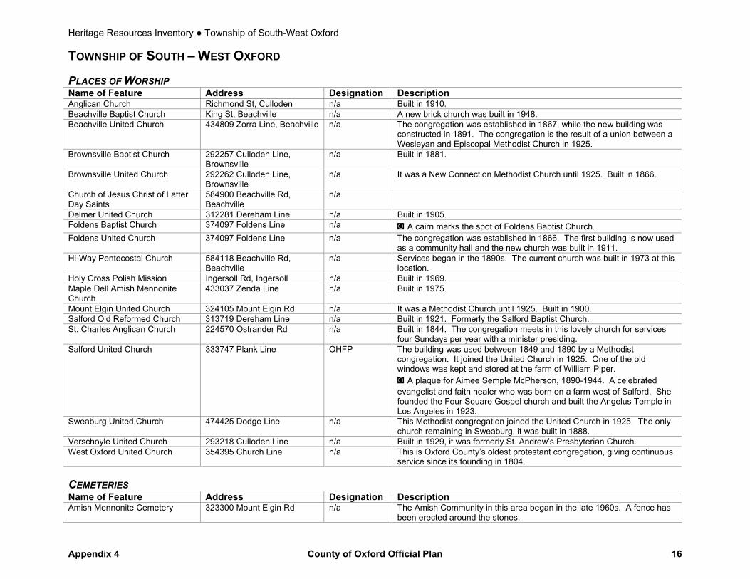
TOWNSHIP OF SOUTH – WEST OXFORD PLACES OF WORSHIP Name of Feature Address Designation Description Anglican Church Richmond St, Culloden n/a Built in 1910. Beachville Baptist Church King St, Beachville n/a A new brick church was built in 1948. Beachville United Church 434809 Zorra Line, Beachville n/a The congregation was established in 1867, while the new building was
constructed in 1891. The congregation is the result of a union between a Wesleyan and Episcopal Methodist Church in 1925.
Brownsville Baptist Church 292257 Culloden Line, Brownsville
n/a Built in 1881.
Brownsville United Church 292262 Culloden Line, Brownsville
n/a It was a New Connection Methodist Church until 1925. Built in 1866.
Church of Jesus Christ of Latter Day Saints
584900 Beachville Rd, Beachville
n/a
Delmer United Church 312281 Dereham Line n/a Built in 1905. Foldens Baptist Church 374097 Foldens Line n/a ◙ A cairn marks the spot of Foldens Baptist Church. Foldens United Church 374097 Foldens Line n/a The congregation was established in 1866. The first building is now used
as a community hall and the new church was built in 1911. Hi-Way Pentecostal Church 584118 Beachville Rd,
Beachville n/a Services began in the 1890s. The current church was built in 1973 at this
location. Holy Cross Polish Mission Ingersoll Rd, Ingersoll n/a Built in 1969. Maple Dell Amish Mennonite Church
433037 Zenda Line n/a Built in 1975.
Mount Elgin United Church 324105 Mount Elgin Rd n/a It was a Methodist Church until 1925. Built in 1900. Salford Old Reformed Church 313719 Dereham Line n/a Built in 1921. Formerly the Salford Baptist Church. St. Charles Anglican Church 224570 Ostrander Rd n/a Built in 1844. The congregation meets in this lovely church for services
four Sundays per year with a minister presiding. Salford United Church
333747 Plank Line OHFP The building was used between 1849 and 1890 by a Methodist congregation. It joined the United Church in 1925. One of the old windows was kept and stored at the farm of William Piper. ◙ A plaque for Aimee Semple McPherson, 1890-1944. A celebrated evangelist and faith healer who was born on a farm west of Salford. She founded the Four Square Gospel church and built the Angelus Temple in Los Angeles in 1923.
Sweaburg United Church 474425 Dodge Line n/a This Methodist congregation joined the United Church in 1925. The only church remaining in Sweaburg, it was built in 1888.
Verschoyle United Church 293218 Culloden Line n/a Built in 1929, it was formerly St. Andrew’s Presbyterian Church. West Oxford United Church 354395 Church Line n/a This is Oxford County’s oldest protestant congregation, giving continuous
service since its founding in 1804. CEMETERIES Name of Feature Address Designation Description Amish Mennonite Cemetery 323300 Mount Elgin Rd n/a The Amish Community in this area began in the late 1960s. A fence has
been erected around the stones.
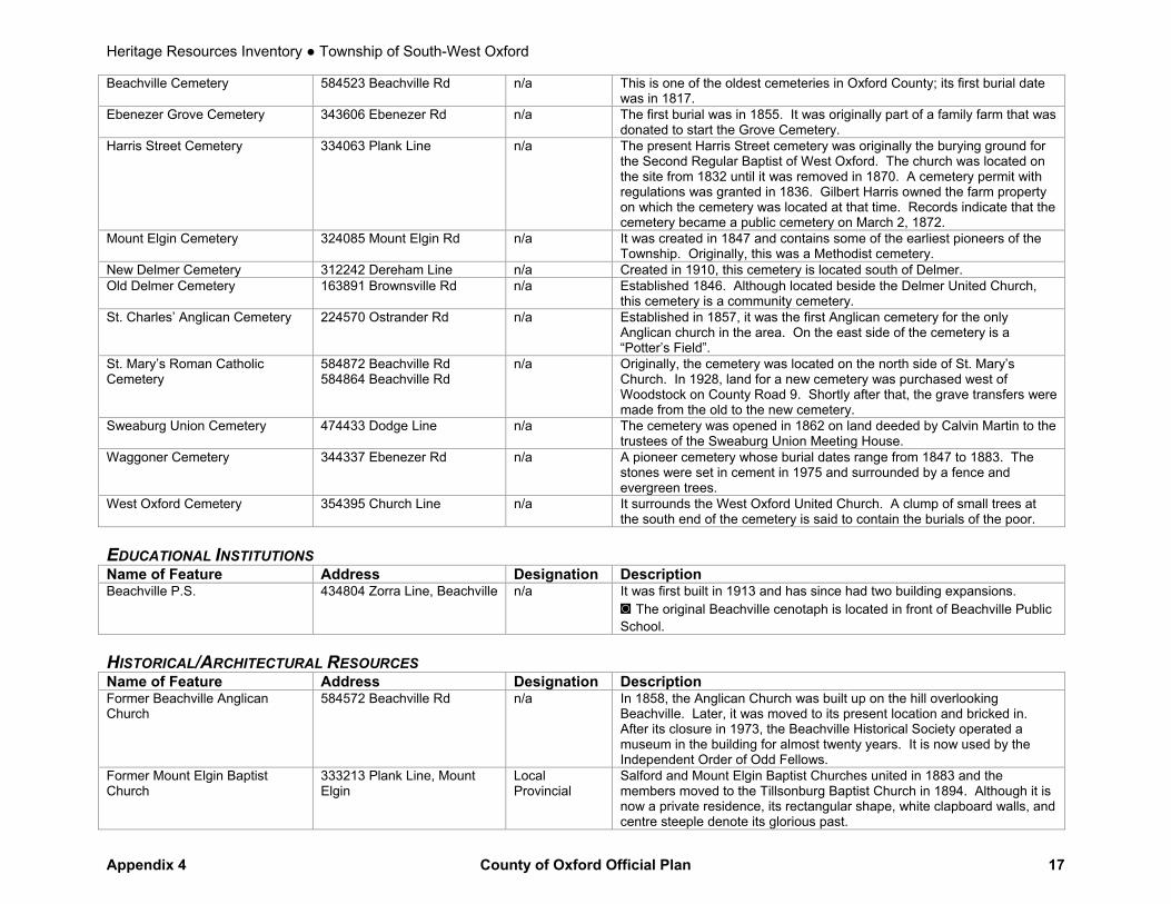
Heritage Resources Inventory ● Township of South-West Oxford
Appendix 4 County of Oxford Official Plan 17
Beachville Cemetery 584523 Beachville Rd n/a This is one of the oldest cemeteries in Oxford County; its first burial date was in 1817.
Ebenezer Grove Cemetery 343606 Ebenezer Rd n/a The first burial was in 1855. It was originally part of a family farm that was donated to start the Grove Cemetery.
Harris Street Cemetery 334063 Plank Line n/a The present Harris Street cemetery was originally the burying ground for the Second Regular Baptist of West Oxford. The church was located on the site from 1832 until it was removed in 1870. A cemetery permit with regulations was granted in 1836. Gilbert Harris owned the farm property on which the cemetery was located at that time. Records indicate that the cemetery became a public cemetery on March 2, 1872.
Mount Elgin Cemetery 324085 Mount Elgin Rd n/a It was created in 1847 and contains some of the earliest pioneers of the Township. Originally, this was a Methodist cemetery.
New Delmer Cemetery 312242 Dereham Line n/a Created in 1910, this cemetery is located south of Delmer. Old Delmer Cemetery 163891 Brownsville Rd n/a Established 1846. Although located beside the Delmer United Church,
this cemetery is a community cemetery. St. Charles’ Anglican Cemetery 224570 Ostrander Rd n/a Established in 1857, it was the first Anglican cemetery for the only
Anglican church in the area. On the east side of the cemetery is a “Potter’s Field”.
St. Mary’s Roman Catholic Cemetery
584872 Beachville Rd 584864 Beachville Rd
n/a Originally, the cemetery was located on the north side of St. Mary’s Church. In 1928, land for a new cemetery was purchased west of Woodstock on County Road 9. Shortly after that, the grave transfers were made from the old to the new cemetery.
Sweaburg Union Cemetery 474433 Dodge Line n/a The cemetery was opened in 1862 on land deeded by Calvin Martin to the trustees of the Sweaburg Union Meeting House.
Waggoner Cemetery 344337 Ebenezer Rd n/a A pioneer cemetery whose burial dates range from 1847 to 1883. The stones were set in cement in 1975 and surrounded by a fence and evergreen trees.
West Oxford Cemetery 354395 Church Line n/a It surrounds the West Oxford United Church. A clump of small trees at the south end of the cemetery is said to contain the burials of the poor.
EDUCATIONAL INSTITUTIONS Name of Feature Address Designation Description Beachville P.S. 434804 Zorra Line, Beachville n/a It was first built in 1913 and has since had two building expansions.
◙ The original Beachville cenotaph is located in front of Beachville Public School.
HISTORICAL/ARCHITECTURAL RESOURCES Name of Feature Address Designation Description Former Beachville Anglican Church
584572 Beachville Rd n/a In 1858, the Anglican Church was built up on the hill overlooking Beachville. Later, it was moved to its present location and bricked in. After its closure in 1973, the Beachville Historical Society operated a museum in the building for almost twenty years. It is now used by the Independent Order of Odd Fellows.
Former Mount Elgin Baptist Church
333213 Plank Line, Mount Elgin
Local Provincial
Salford and Mount Elgin Baptist Churches united in 1883 and the members moved to the Tillsonburg Baptist Church in 1894. Although it is now a private residence, its rectangular shape, white clapboard walls, and centre steeple denote its glorious past.

Heritage Resources Inventory ● Township of South-West Oxford
Appendix 4 County of Oxford Official Plan 18
CULTURAL RESOURCES Name of Feature Address Designation Description Beachville Heritage Museum 584371 Beachville Rd,
Beachville n/a Located in the former home of one of the managers of the Beachville
mine, this museum has a wealth of local history, artifacts and information. Beachville Public Library 4 Main St E, Beachville
n/a A branch of the Oxford County Library. Office building constructed in
1867. Brownsville Community Hall 163518 Brownsville Rd,
Brownsville This building was once the Delmer Methodist Meeting House. After the
Second World War, a basement was dug by members of the community and the building was dedicated as a war memorial. In 1967, the Brownsville Centennial project was to add a kitchen and a library to the existing structure.
Brownsville Public Library 163518 Brownsville Rd, Brownsville
n/a A branch of the Oxford County Library; located in the Brownsville Community Hall. ◙ The Brownsville Cheese Company plaque was donated by the Brownsville Women’s Institute in 1966, the last year of operations of the plant. It commemorates the first joint cheese stock company and the first powdered milk manufactured in Canada.
Mount Elgin Public Library 333204 Plank Line, Mount Elgin
n/a A branch of the Oxford County Library; located in the Mount Elgin Community Centre.
NATURAL AREAS AND PARKS Name of Feature Address Designation Description Beachville Conservation Area Zorra Line n/a 0.5 ha (1.25 acres) day use picnic area. Part of the Upper Thames River
Conservation Authority. Brownsville Community Centre Park
292238 Culloden Line n/a ◙ The gateway into the park is a memorial. The Brownsville cenotaph has been dismantled due to vandalism.
Centreville Pond Park 584090 Beachville Road n/a A creek runs through the property. The dam is maintained by the Upper Thames River Conservation Authority.
Dereham Wetlands Conservation Area
312731 Dereham Line 312722 Dereham Line
n/a 59 ha (145 acres) for passive recreation and hunting. Part of the Long Point Region Conservation Authority.
Lawson Tract 363685 McBeth Rd n/a The family of Dr. John Lawson of Ingersoll Ontario donated this 14.5 ha (36 acre) parcel of property to the Federation of Ontario Naturalists. Dr. Lawson was a member of the Ingersoll Nature Club who loved nature and hoped to preserve it for future generations. This property consists of 4 ha (10 acres) of designated wet lands and 10.5 ha (26 acres) of mixed vegetation. There is a variety of plant life which is interesting to observe as it changes with the seasons.
Foldens Reforested Area 374153 Foldens Line n/a This property, which is owned by the Township of South-West Oxford, contains 18.2 ha (45 acres) of reforested area.
Hawkins Tract
143659 Hawkins Rd n/a 40.5 ha (100 acres) of Carolinian Forest. Part of the Catfish Creek Conservation Authority.
Hughes Tract 243790 Airport Rd 243762 Airport Rd 243734 Airport Rd 243700 Airport Rd 243680 Airport Rd
n/a 61ha (150 acres) for passive recreation and hunting. Part of the Long Point Region Conservation Authority.

Heritage Resources Inventory ● Township of South-West Oxford
Appendix 4 County of Oxford Official Plan 19
Trillium Woods Provincial Natural Reserve
454419 Trillium Line n/a This 10 ha (25 acre) parcel of land is the County’s only Provincial Park. Near the northern limit of the Carolinian forest region and supports a mature forest of sugar maple, white ash, black cherry, bitternut hickory, beech and butternut.
PLAQUES AND MONUMENTS Name of Feature Address Designation Description Beachville Cenotaph 434852 Zorra Line n/a ◙ It is located at the Royal Canadian Legion Branch 495. Dereham School S.S. No. 6 323 Mount Elgin Rd n/a ◙ The Verschoyle Women’s Institute erected this cairn in 1975 and the
Verschoyle Community club in honour of the Verschoyle community who have worked for better education from pioneer days. The cairn contains the bell and bricks from the S.S. No. 6 Dereham School, 1876-1973.
John (Nick) Meathrell Bridge Water Works Road bridge, west of Ingersoll, north from CR 9
n/a ◙ Commemorates Oxford's first professional engineer who oversaw the development of the County Road System from 1928 to his retirement in 1968.
Public School S.S. No. 5 324119 Mount Elgin Rd n/a ◙ Northeast corner of Plank Line and Mount Elgin Road. A cairn erected by the Mount Elgin Women’s Institute in 1964 to commemorate the Public School S.S. No. 5, 1872-1954.
Robert F. Gourlay, 1778-1863 333227 Plank Line OHFP Southwest corner of Plank Line and Mount Elgin Road. ◙ Robert Gourlay was a radical Scot who crusaded for social reform in Britain and Upper Canada in the early 19th century.
Spike Caldwell Bridge On northwest and southeast approaches of bridge on CR 45 north of Putnam
n/a ◙ Commemorates the District Municipal Engineer who from 1939-1970 worked at the Provincial DHO London office in support of County Engineers in Oxford, Middlesex and Elgin
S.S. No. 2 Dereham School Area 383908 Salford Rd n/a The Salford Community Centre is located on the former S.S. No. 2 Dereham School Area (1958). There is a stone cairn with three plaques on the north side and a school bell on the top: ◙ “To commemorate Salford School S.S. #2 Dereham 1877 – 1958” Erected by Salford Women’s Institute Centennial Project ◙ Pioneer School Teacher Lydia Chase Ranney 1801 – 1901, Wife of Hiram Ranney, journeyed from Massachusetts, U.S.A. to Oxford County 1834. The first school teacher in Oxford County to receive a legislative grant. Building was located one block west. The first maker of cheddar cheese in Canada. Interred in the Harris Street Cemetery, West Oxford Township. ◙ Evangelist Aimee Kennedy Semple McPherson, Founder of Angelus Temple, Los Angeles, California, U.S.A. Born Salford, Ontario / 1890. Interred Glendale, California / 1944. Daughter of James Morgan Kennedy. Interred Harris Street Cemetery, West Oxford Township.
Heritage Resources Inventory ● Township of South-West Oxford
Appendix 4 County of Oxford Official Plan 20
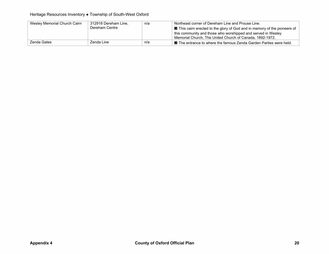
Wesley Memorial Church Cairn 312918 Dereham Line, Dereham Centre
n/a Northeast corner of Dereham Line and Prouse Line. ◙ This cairn erected to the glory of God and in memory of the pioneers of this community and those who worshipped and served in Wesley Memorial Church, The United Church of Canada, 1892-1972.
Zenda Gates Zenda Line n/a ◙ The entrance to where the famous Zenda Garden Parties were held.
Heritage Resources Inventory ● Township of Zorra
Appendix 4 County of Oxford Official Plan 21
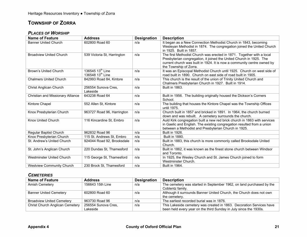
TOWNSHIP OF ZORRA PLACES OF WORSHIP Name of Feature Address Designation Description Banner United Church 602800 Road 60 n/a It began as a New Connection Methodist Church in 1843, becoming
Wesleyan Methodist in 1874. The congregation joined the United Church in 1925. Built in 1857.
Broadview United Church 539 Victoria St, Harrington n/a The first Methodist Church was erected in 1871. Together with a local Presbyterian congregation, it joined the United Church in 1925. The current church was built in 1924. It is now a community centre owned by the Township of Zorra.
Brown’s United Church 136545 13th Line 136548 13th Line
n/a It was an Episcopal Methodist Church until 1925. Church on west side of road built in 1890. Church on east side of road built in 1905.
Chalmers United Church 842993 Road 84, Kintore n/a This church is the result of the union of Trinity United Church and Chalmers Presbyterian Church in 1927. Built in 1914.
Christ Anglican Church 256554 Sunova Cres, Lakeside
n/a Built in 1863.
Christian and Missionary Alliance 643238 Road 64 n/a Built in 1956. The building originally housed the Dickson’s Corners School.
Kintore Chapel 552 Allen St, Kintore n/a The building that houses the Kintore Chapel was the Township Offices until 1975.
Knox Presbyterian Church 963727 Road 96, Harrington n/a Church built in 1857 and bricked in 1891. In 1964, the church burned down and was rebuilt. A cemetery surrounds the church.
Knox United Church 116 Kincardine St, Embro n/a Auld Kirk congregation built a new red brick church in 1863 with services in Gaelic and English. The existing congregation resulted from a union between a Methodist and Presbyterian Church in 1925.
Regular Baptist Church 962832 Road 96 n/a Built in 1926. Knox Presbyterian Church 115 St. Andrews St, Embro n/a Built in 1880. St. Andrew’s United Church 924044 Road 92, Brooksdale n/a Built in 1883, this church is more commonly called Brooksdale United
Church. St. John’s Anglican Church 220 Dundas St, Thamesford n/a Built in 1862, it was known as the finest stone church between Windsor
and Toronto. Westminster United Church 115 George St, Thamesford n/a In 1925, the Wesley Church and St. James Church joined to form
Westminster Church. Westview Community Church 230 Brock St, Thamesford n/a Built in 1964. CEMETERIES Name of Feature Address Designation Description Amish Cemetery 156643 15th Line n/a The cemetery was started in September 1962, on land purchased by the
Coblentz family. Banner United Cemetery 602800 Road 60 n/a Although it surrounds Banner United Church, the Church does not own
the cemetery. Broadview United Cemetery 963730 Road 96 n/a The earliest recorded burial was in 1876. Christ Church Anglican Cemetery 256554 Sunova Cres,
Lakeside n/a This Lakeside cemetery was created in 1863. Decoration Services have
been held every year on the third Sunday in July since the 1930s.
Heritage Resources Inventory ● Township of Zorra
Appendix 4 County of Oxford Official Plan 22
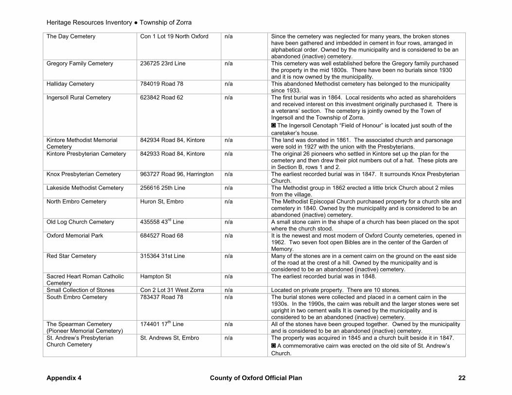
The Day Cemetery Con 1 Lot 19 North Oxford n/a Since the cemetery was neglected for many years, the broken stones have been gathered and imbedded in cement in four rows, arranged in alphabetical order. Owned by the municipality and is considered to be an abandoned (inactive) cemetery.
Gregory Family Cemetery 236725 23rd Line n/a This cemetery was well established before the Gregory family purchased the property in the mid 1800s. There have been no burials since 1930 and it is now owned by the municipality.
Halliday Cemetery 784019 Road 78 n/a This abandoned Methodist cemetery has belonged to the municipality since 1933.
Ingersoll Rural Cemetery 623842 Road 62 n/a The first burial was in 1864. Local residents who acted as shareholders and received interest on this investment originally purchased it. There is a veterans’ section. The cemetery is jointly owned by the Town of Ingersoll and the Township of Zorra. ◙ The Ingersoll Cenotaph “Field of Honour” is located just south of the caretaker’s house.
Kintore Methodist Memorial Cemetery
842934 Road 84, Kintore n/a The land was donated in 1861. The associated church and parsonage were sold in 1927 with the union with the Presbyterians.
Kintore Presbyterian Cemetery 842933 Road 84, Kintore n/a The original 26 pioneers who settled in Kintore set up the plan for the cemetery and then drew their plot numbers out of a hat. These plots are in Section B, rows 1 and 2.
Knox Presbyterian Cemetery 963727 Road 96, Harrington n/a The earliest recorded burial was in 1847. It surrounds Knox Presbyterian Church.
Lakeside Methodist Cemetery 256616 25th Line n/a The Methodist group in 1862 erected a little brick Church about 2 miles from the village.
North Embro Cemetery Huron St, Embro n/a The Methodist Episcopal Church purchased property for a church site and cemetery in 1840. Owned by the municipality and is considered to be an abandoned (inactive) cemetery.
Old Log Church Cemetery 435558 43rd Line n/a A small stone cairn in the shape of a church has been placed on the spot where the church stood.
Oxford Memorial Park 684527 Road 68 n/a It is the newest and most modern of Oxford County cemeteries, opened in 1962. Two seven foot open Bibles are in the center of the Garden of Memory.
Red Star Cemetery 315364 31st Line n/a Many of the stones are in a cement cairn on the ground on the east side of the road at the crest of a hill. Owned by the municipality and is considered to be an abandoned (inactive) cemetery.
Sacred Heart Roman Catholic Cemetery
Hampton St n/a The earliest recorded burial was in 1848.
Small Collection of Stones Con 2 Lot 31 West Zorra n/a Located on private property. There are 10 stones. South Embro Cemetery 783437 Road 78 n/a The burial stones were collected and placed in a cement cairn in the
1930s. In the 1990s, the cairn was rebuilt and the larger stones were set upright in two cement walls It is owned by the municipality and is considered to be an abandoned (inactive) cemetery.
The Spearman Cemetery (Pioneer Memorial Cemetery)
174401 17th Line n/a All of the stones have been grouped together. Owned by the municipality and is considered to be an abandoned (inactive) cemetery.
St. Andrew’s Presbyterian Church Cemetery
St. Andrews St, Embro n/a The property was acquired in 1845 and a church built beside it in 1847. ◙ A commemorative cairn was erected on the old site of St. Andrew’s Church.
Heritage Resources Inventory ● Township of Zorra
Appendix 4 County of Oxford Official Plan 23
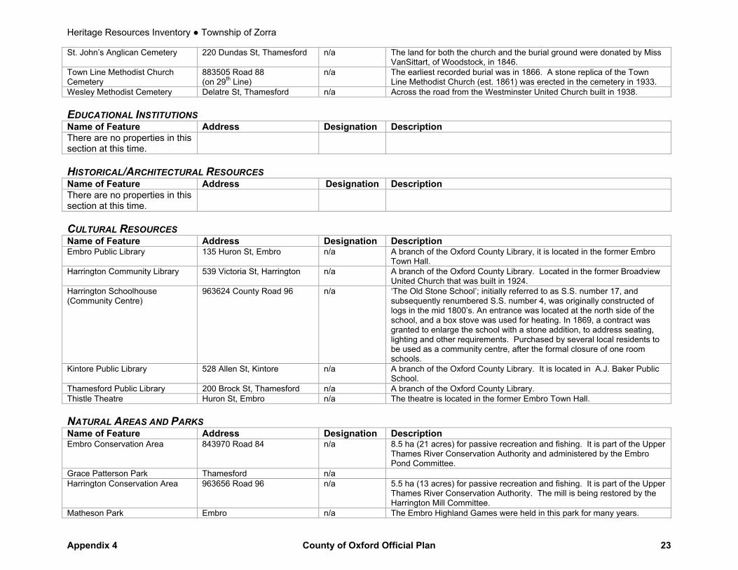
St. John’s Anglican Cemetery 220 Dundas St, Thamesford n/a The land for both the church and the burial ground were donated by Miss VanSittart, of Woodstock, in 1846.
Town Line Methodist Church Cemetery
883505 Road 88 (on 29th Line)
n/a The earliest recorded burial was in 1866. A stone replica of the Town Line Methodist Church (est. 1861) was erected in the cemetery in 1933.
Wesley Methodist Cemetery Delatre St, Thamesford n/a Across the road from the Westminster United Church built in 1938. EDUCATIONAL INSTITUTIONS Name of Feature Address Designation Description There are no properties in this section at this time.
HISTORICAL/ARCHITECTURAL RESOURCES Name of Feature Address Designation Description There are no properties in this section at this time.
CULTURAL RESOURCES Name of Feature Address Designation Description Embro Public Library 135 Huron St, Embro n/a A branch of the Oxford County Library, it is located in the former Embro
Town Hall. Harrington Community Library 539 Victoria St, Harrington
n/a A branch of the Oxford County Library. Located in the former Broadview
United Church that was built in 1924. Harrington Schoolhouse (Community Centre)
963624 County Road 96 n/a ‘The Old Stone School’; initially referred to as S.S. number 17, and subsequently renumbered S.S. number 4, was originally constructed of logs in the mid 1800’s. An entrance was located at the north side of the school, and a box stove was used for heating. In 1869, a contract was granted to enlarge the school with a stone addition, to address seating, lighting and other requirements. Purchased by several local residents to be used as a community centre, after the formal closure of one room schools.
Kintore Public Library 528 Allen St, Kintore n/a A branch of the Oxford County Library. It is located in A.J. Baker Public School.
Thamesford Public Library 200 Brock St, Thamesford n/a A branch of the Oxford County Library. Thistle Theatre Huron St, Embro n/a The theatre is located in the former Embro Town Hall. NATURAL AREAS AND PARKS Name of Feature Address Designation Description Embro Conservation Area 843970 Road 84 n/a 8.5 ha (21 acres) for passive recreation and fishing. It is part of the Upper
Thames River Conservation Authority and administered by the Embro Pond Committee.
Grace Patterson Park Thamesford n/a Harrington Conservation Area 963656 Road 96 n/a 5.5 ha (13 acres) for passive recreation and fishing. It is part of the Upper
Thames River Conservation Authority. The mill is being restored by the Harrington Mill Committee.
Matheson Park Embro n/a The Embro Highland Games were held in this park for many years.
Heritage Resources Inventory ● Township of Zorra
Appendix 4 County of Oxford Official Plan 24
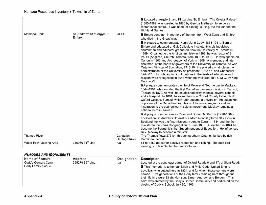
◙ Located at Argyle St and Kincardine St, Embro. “The Crystal Palace” (1885-1982) was created in 1885 by George Matheson to serve as recreational centre. It was used for skating, curling, the fall fair and the Highland Games.
Memorial Park St. Andrews St at Argyle St, Embro
OHFP ◙ Embro cenotaph in memory of the men from West Zorra and Embro who died in the Great War. ◙ A plaque to commemorate Henry John Cody, 1868-1951. Born at Embro and educated at Galt Collegiate Institute, this distinguished churchman and educator graduated from the University of Toronto in 1889. Ordained to the Anglican ministry in 1893, he was rector of St. Paul's [Anglican] Church, Toronto, from 1899 to 1932. He was appointed Canon in 1903 and Archdeacon of York in 1909. A member, and later chairman, of the board of governors of the University of Toronto, he was Ontario's Minister of Education, 1918-19. He played a vital role in the administration of the University as president, 1932-45, and Chancellor, 1944-47. His outstanding contributions in the fields of education and religion were recognized in 1943 when he was created a C.M.G. by King George VI. ◙A plaque commemorates the life of Reverend George Leslie Mackay, 1844-1901, who founded the first Canadian overseas mission in Tamsui, Taiwan, in 1872. As well, he established sixty chapels, several schools and a hospital. In 1881, he raised funds in Oxford County to help build Oxford College, Tamsui, which later became a university. An outspoken opponent of the Canadian head tax on Chinese immigrants and an inspiration to the evangelical missions movement, Mackay remains a national hero in Taiwan. ◙ A plaque commemorates Reverend Donald McKenzie (1798-1884). Located on St. Andrews St, east of Oxford Road 6 (Huron St.) Born in Scotland, he was the first missionary sent to Zorra in 1834 and the first minister to the Zorra Congregation in June 1835. A teacher, in 1844 he became the Township's first Superintendent of Education. He influenced Rev. Mackay to become a minister
Thames River Canadian Heritage River
The Thames flows 273 km through southern Ontario, flanked by rich Carolinean forest.
Water Fowl Viewing Area 316960 31st Line n/a 61 ha (150 acres) for passive recreation and fishing. The best bird viewing is in late September and October.
PLAQUES AND MONUMENTS Name of Feature Address Designation Description Cody's Corners Cairn Cody Family plaque
395279 39th Line n/a Located at the southeast corner of Oxford Roads 6 and 17, at Slant Road. ◙ This memorial is to honour Elijah and Phila Cody, United Empire Loyalists, who settled here in 1824, and for whom these corners were named. Five generations of the Cody family residing here throughout their lifetime were Elijah, Harrison, Elmer, Andrew, and Bryden. This cairn was erected by the Cody’s Corner Community and dedicated on the closing of Cody’s School, July 30, 1966.

Heritage Resources Inventory ● Township of Zorra
Appendix 4 County of Oxford Official Plan 25
North Oxford Cenotaph 274620 27th Line n/a ◙ It is located at the Zorra Municipal Offices. Oswald J. Smith 395279 39th Line n/a ◙ Born in Odessa, November 8, 1889. He spent most of his boyhood
years in Embro and attended school at Cody’s Corners. His name symbolizes worldwide evangelization. In 1928 he founded The Peoples Church, which may be the largest church in Canada with an income for World Missions of more than one million dollars annually. As a missionary statesman he visited seventy-two countries and received the F.R.G.S. degree. His thirty-six books have been translated into 125 languages of which over six million copies have been circulated. His twelve hundred hymns and poems make him one of the most prolific song writers. Dr. Billy Graham has called him, “The most remarkable man I’ve ever met.”
Robert Douglas Hayward 395279 39th Line n/a ◙ Oct. 27, 1927 – Sept. 10, 1961. Bob Hayward brought international fame to Canada and to this area when he drove the world champion speedboat MISS SUPERTEST III to victory, winning for Canada the Harmsworth (British International) Trophy, August 27, 1959, and which he successfully defended in 1960 and 1961. His cairn is erected to his memory on the former Hayward Farm where Bob was born and raised, and dedicated on the closing of Cody’s School, July 30, 1966.
Sarah Clark 602800 Twp Rd 60, Banner n/a ◙ Located in the Hamlet of Banner, on Township Rd 60 and the 15th Line. Metal plaque affixed to a boulder at the intersection commemorates this Postmistress, 1893-1914.
West Zorra and Embro Agricultural Society
Argyle St, Embro n/a Located at Argyle St and Kincardine St, Embro. ◙ A plaque in recognition of 100 years of service, 1856-1956.
Youngsville 376194 37th Line n/a Located on the southeast corner of Oxford Road 6 and Oxford Road 8, north of Embro. ◙ In 1830 Gabriel Youngs came from New York State & purchased 1000 acres of land surrounding these crossroads. The Great Western Hotel built on this site before 1850 served settlers travelling from Beachville to Stratford. This being the central point of the Township, the West Zorra Council met here from 1850 to 1911. A post office was located in the hotel from 1874 to 1902. A blacksmith shop, carriage-works & dwellings were located here, and in 1866 a school was built. The school and hotel were demolished in the 1960s.
Zorra Tug of War Team Oxford Road 6, Embro n/a ◙ Located at the west end of the North Embro Cemetery. World champions at the Chicago World's Fair of 1893. The Gaelic inscription translates as "Men of might who feared the Lord".
Heritage Resources Inventory ● City of Woodstock
Appendix 4 County of Oxford Official Plan 26
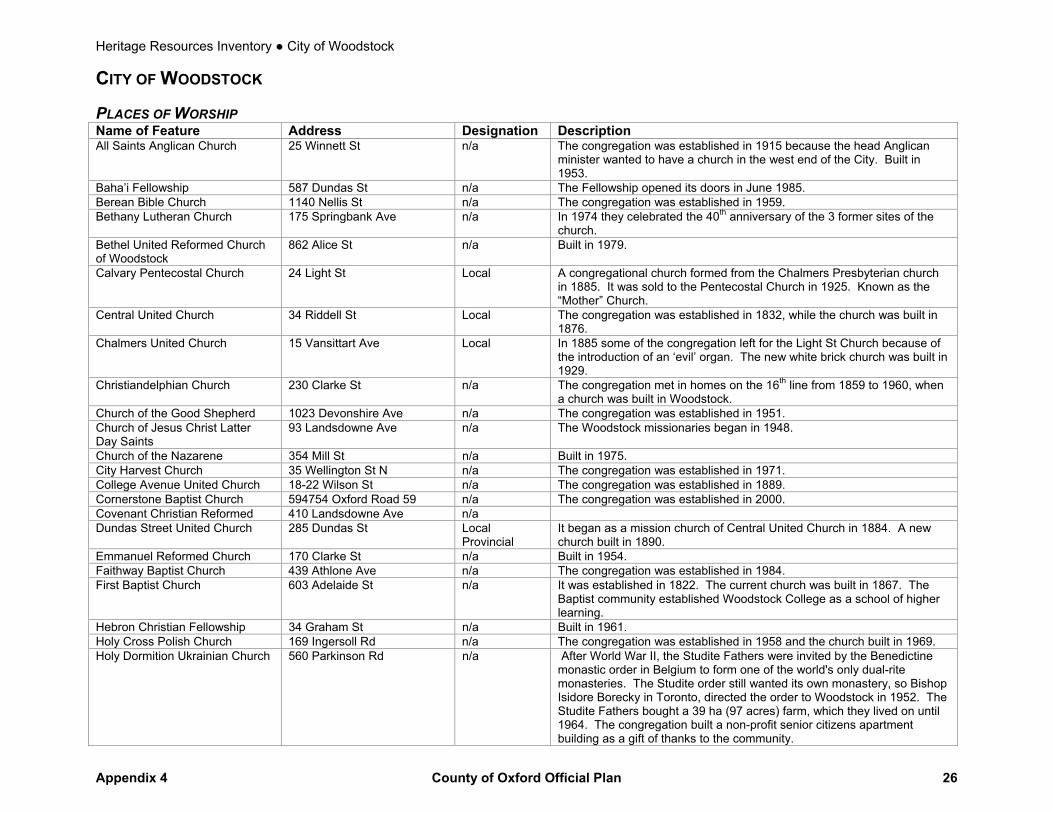
CITY OF WOODSTOCK PLACES OF WORSHIP Name of Feature Address Designation Description All Saints Anglican Church 25 Winnett St n/a The congregation was established in 1915 because the head Anglican
minister wanted to have a church in the west end of the City. Built in 1953.
Baha’i Fellowship 587 Dundas St n/a The Fellowship opened its doors in June 1985. Berean Bible Church 1140 Nellis St n/a The congregation was established in 1959. Bethany Lutheran Church 175 Springbank Ave n/a In 1974 they celebrated the 40th anniversary of the 3 former sites of the
church. Bethel United Reformed Church of Woodstock
862 Alice St n/a Built in 1979.
Calvary Pentecostal Church 24 Light St Local A congregational church formed from the Chalmers Presbyterian church in 1885. It was sold to the Pentecostal Church in 1925. Known as the “Mother” Church.
Central United Church 34 Riddell St Local The congregation was established in 1832, while the church was built in 1876.
Chalmers United Church 15 Vansittart Ave Local In 1885 some of the congregation left for the Light St Church because of the introduction of an ‘evil’ organ. The new white brick church was built in 1929.
Christiandelphian Church 230 Clarke St n/a The congregation met in homes on the 16th line from 1859 to 1960, when a church was built in Woodstock.
Church of the Good Shepherd 1023 Devonshire Ave n/a The congregation was established in 1951. Church of Jesus Christ Latter Day Saints
93 Landsdowne Ave n/a The Woodstock missionaries began in 1948.
Church of the Nazarene 354 Mill St n/a Built in 1975. City Harvest Church 35 Wellington St N n/a The congregation was established in 1971. College Avenue United Church 18-22 Wilson St n/a The congregation was established in 1889. Cornerstone Baptist Church 594754 Oxford Road 59 n/a The congregation was established in 2000. Covenant Christian Reformed 410 Landsdowne Ave n/a Dundas Street United Church 285 Dundas St Local
Provincial It began as a mission church of Central United Church in 1884. A new church built in 1890.
Emmanuel Reformed Church 170 Clarke St n/a Built in 1954. Faithway Baptist Church 439 Athlone Ave n/a The congregation was established in 1984. First Baptist Church 603 Adelaide St n/a It was established in 1822. The current church was built in 1867. The
Baptist community established Woodstock College as a school of higher learning.
Hebron Christian Fellowship 34 Graham St n/a Built in 1961. Holy Cross Polish Church 169 Ingersoll Rd n/a The congregation was established in 1958 and the church built in 1969. Holy Dormition Ukrainian Church 560 Parkinson Rd n/a After World War II, the Studite Fathers were invited by the Benedictine
monastic order in Belgium to form one of the world's only dual-rite monasteries. The Studite order still wanted its own monastery, so Bishop Isidore Borecky in Toronto, directed the order to Woodstock in 1952. The Studite Fathers bought a 39 ha (97 acres) farm, which they lived on until 1964. The congregation built a non-profit senior citizens apartment building as a gift of thanks to the community.
Heritage Resources Inventory ● City of Woodstock
Appendix 4 County of Oxford Official Plan 27
Huron Park Baptist Church 215 Berwick St n/a Built in 1965. Jehovah’s Witness Kingdom Hall 1162 Nellis St n/a Built in 1989. Knox Presbyterian Church 59 Riddell St Local
Provincial The first church burned in 1897. It was established in 1844 after St. Andrew’s Church separated.
Maranatha Christian Reformed Church
577 Norwich Ave n/a Built in 1949.
New Apostolic Church 45 Cronyn St n/a Built in 1963. New St. Paul’s Anglican Church 560 Dundas St n/a It was built in 1880 to replace Old St. Paul’s Church; however the ‘Old’
Church was reopened in 1882 at the request of the congregation. Old St. Paul’s Anglican Church 723 Dundas St E Local,
Provincial, Provincial Easement, OHFP
This church (1834) is associated with the very early days of Woodstock and was financed through the efforts of Admiral Henry Vansittart and built under the direction of Captain Andrew Drew, R.N. It was used as a temporary jail during the 1837 Rebellion. �
Oxford St Baptist Church 278 Hunter St n/a It was influenced by Woodstock College since many of the pastors in its first 30 years graduated from it. The congregation was established in 1890.
Plymouth Brethren Longworth Lane n/a River of Life Christian Fellowship 415 Dundas St n/a The congregation was established in 1999. Salvation Army Church 769 Julianna Dr n/a The congregation was established in 1886. Seventh Day Adventist Church 594754 Highway 59 S
n/a Built in 1973.
St. Mary’s Roman Catholic Church
155 Oxford St n/a The oldest Roman Catholic Church in Woodstock (1874).
St. Rita of Cascia Church 904 Dundas St n/a The congregation was established in 1954 after the school by the same name was built.
St. David’s United Church 190 Springbank Ave N n/a Built in 1962, this is the newest United Church in Woodstock. Woodstock Community Church 419-B Dundas St n/a It is located in a building which was constructed in 1893. CEMETERIES Name of Feature Address Designation Description Anglican Cemetery VanSittart Ave n/a This attractive cemetery lies on the east side of VanSittart Avenue,
opposite the Baptist Cemetery. The property was purchased from the estate of the Honourable George Alexander.
Baptist Cemetery VanSittart Ave n/a Land was purchased in 1867 for the current cemetery. A previous chapel and cemetery were located on Chapel Street.
Hillview United Cemetery Fifth Ave n/a The original cemetery was established in 1864, and located at the corner of VanSittart Avenue and Buller Street. In 1880, the graves were removed to a new cemetery, which was located at the southwesterly town limits.
House of Refuge 515137 11th Line n/a Many residents of the Oxford County Industrial farm and House of Refuge were buried in this cemetery from 1895-1956. A cross has been erected, inscribed with the names of those buried there.
Old St. Paul’s Anglican Cemetery 723 Dundas St E n/a It was closed in 1873 when a new one was opened. Its restoration began in 1932. This cemetery is located around the first Anglican Church in Woodstock.

Heritage Resources Inventory ● City of Woodstock
Appendix 4 County of Oxford Official Plan 28
Woodstock Presbyterian Cemetery
VanSittart Ave OHFP Land was granted for use as a burying ground for Presbyterians in 1849. ◙ A large memorial was erected to Malcolm McKenzie, the first person from Oxford to die in the Fenian Raids. For many years, County Council observed a silence in Malcolm McKenzie's honour, but eventually this was stopped and even the memorial was forgotten. About 25 - 30 years ago, the memorial was restored, although it was forgotten again. "Erected by the people of the County of Oxford in memory of Malcolm McKenzie who fell at Ridgeway June 2, 1866. Age 27 years." ◙ A plaque for Lieutenant-Colonel Joseph Whiteside Boyle, D.S.O. 1867-1923. Woodstock native later known as "Klondyke Joe" for his activities in the Yukon Gold Rush where he was a prospector and investor in timber and electric power operations. During WW I he funded and commanded his own machine gun battalion. His exploits on behalf of the people of Romania are legendary.
EDUCATIONAL INSTITUTIONS Name of Feature Address Designation Description Broadway P.S 81 Broadway St n/a It was originally built in 1888 to alleviate overcrowding at Central, East
End and West End Schools. Central Sn. P.S. 410 Hunter St n/a Originally built in 1880, Central Public School was the third school built in
the City. Chapel P.S. 27 Chapel St n/a Built in 1890. College Avenue S.S. 700 College Ave OHFP ◙ Sponsored by the Baptists and first named the Canadian Literary
Institute, this famous co-educational institution (Woodstock College) was opened in 1860 offering courses in theology and the arts. At one time it was expected to attain full university status, but it became purely a boys' preparatory school in 1890, and closed in 1926. ◙ A plaque for the Reverend Newton Wolverton, (1846-1932). Noted expert on meteorology, teacher of mathematics and Baptist minister, he was principal of Woodstock College 1881-1886, where he established Canada's first manual training department.
Fanshawe College 369 Finkle St n/a Previously, this satellite campus of Fanshawe College had been located in the old House of Refuge.
Northdale P.S. 290 Victoria St N n/a Built in 1950. The Woodstock Development Centre for children with multiple disabilities is located here.
St. Mary’s High School 431 Juliana Dr n/a The building was built in 1997. It was originally built in 1902 beside the associated Parish; part of the graveyard needed to be moved in 1928 for the school’s expansion.
Victoria P.S. 45 Delatre St n/a The West End School was built in 1854. In 1910, the old school was torn down when it was replaced by a new building which was renamed in honour of Queen Victoria.
Woodstock Collegiate Institute 35 Riddell St n/a This historic building was constructed in 1939.

Heritage Resources Inventory ● City of Woodstock
Appendix 4 County of Oxford Official Plan 29
HISTORICAL/ARCHITECTURAL RESOURCES Name of Feature Address Designation Description Captain Andrew Drew House “Drew Cottage”
735 Rathbourne Ave Local, Provincial, OHFP
Built in 1833. ◙ Drew divided the eastern section of town into town lots and formed the nucleus of this community. ◙ A plaque for Captain Andrew Drew, R.N., 1792-1878. Co-founder of Woodstock with Admiral Vansittart. He led the loyalist forces, which destroyed the American steamer Caroline during the 1837 Rebellion.
Gowanbank 329 Light St Local Queen Anne and Tudor Revival style home complete with a round tower with a cone roof.
Hawkin’s Chapel North of Park Row west of Mill St
n/a A movement to build a church for black people resulted in its construction in 1888. The church closed in 1985 when it was sold for a house.
Henderson House; Norwood; “Norway Villa”; Thomas K. Parker House
84 VanSittart Ave Local An Italianate style home built in 1864 by Mayor Tomas H. Parker (1878 and 1879).
Homer Pratt Brown house and coach house
82 Wellington St N Local Provincial
Cornis style house. It was built in 1860 for the family of Jennifer and Homer Pratt Brown, who was a partner in the ‘Woodstock Foundry’.
Hugh Richardson House 419 Vincent St Local Neo-classical style house built in 1849. The first owner, Hugh Richardson, was the presiding judge at the Louis Riel trial in 1885.
James Hay residence 77 Light St Local An Italianate style home built in 1878. There is a lamppost from the Vansittart farm on the property. ◙ A plaque for James Hay, a well-known industrialist born in Woodstock, who was one of the founders of the Board of Trade in 1878, elected to Town Council in 1880 and Mayor between 1893 and 1894.
The Market Building Market Square (Peel St)
Provincial Built in 1895. The low roof and wide canopies are typical of market construction of the period. Home of the Woodstock Little Theatre.
Museum Square 466 Dundas St Local National
Located in front of the old Town Hall National Historic Site; originally constructed in 1853.
Nesbitt Family House 257 Light St Local Provincial
The Nesbitt family was socially and politically prominent in Woodstock and in Oxford County, contributing greatly to community life. The house is an example of the "Second Empire" style of architecture, popular in the 1860 to 1880 era. Canada adopted the Second Empire style as its official style.
Old Registry Office Building 419 Hunter St Local Home of the Oxford Historical and Genealogical Societies. ◙ The first Registry office built in Oxford County was located west of here at the corner of Hunter and Light Streets, Woodstock, 1847. This building, the second Registry Office, was constructed in 1876 and remained in use until 1952. Five registrars of deeds served Oxford in their private homes and in these offices. Capt. Thomas Horner 1800-1834, James Ingersoll 1834-1886, George R. Pattullo 1886-1922, Wallace L. MacWhinnie 1922-1950, Ross V. Tuck 1950-1969
Oxford County Court House 415 Hunter St Local Provincial
Built in 1890. ◙ A national plaque briefly notes the construction, financial and legal difficulties attendant upon the erection of this massive nineteenth century structure. The Centenary stone is mounted in the central buttress. ◙ There is also a monument with inscriptions for two men who served in the 22nd Battalion (Oxford Rifles) during the Boer War. Colour Sergeant George Leonard, who died of wounds received in the Zand River conflict,

Heritage Resources Inventory ● City of Woodstock
Appendix 4 County of Oxford Official Plan 30
May 10, 1901; and Corporal Davidson, who died of enteric fever on Feb. 6, 1902. ◙ A national plaque dedicated to Sir Francis Hincks, 1807-1885. Francis Hincks was born in Ireland. He came to the Canadas in 1830 and in 1841 was elected as Member for Oxford. He joined the Reformers in the struggle for responsible Government. He was their financial expert, an advocate of railway building and, with A.-N. Morin, led the government of the Province of Canada from 1851 to 1854. After serving as Governor of Barbados and British Guiana, 1856-1869, he returned to Canada. As Finance Minister in the Macdonald government he framed the Bank Act of 1871 which laid the foundation of Canada’s banking system. In 1873 he returned to business life in Montreal where he died.
Oxford County Gaol (Oxford County Board of Health)
424 Buller St Local, Provincial, Provincial Easement
It was built in 1854 and is an example of Italianate Romanesque Architecture with Tuscan Gothic details. It was the fifth jail built by the Province. Five hangings took place within the gaol walls although the last hanging was the only one performed in the building. The building has been recognized by the National Inventory of Historic Buildings.
Perry-Hill Home; “House of the Valley”
130 Finkle St Local Ontario vernacular style. It is the oldest house in Woodstock, built in 1819 by Dr. Perry, the first doctor and teacher in Woodstock.
Perry Street Fire Hall 12 Perry St Local Provincial
Built in 1900, the old fire hall has been more recently restored as an office building.
Princess Street Professional Building
600 Princess St n/a Formerly the Princess School, built in 1910. Until it closed in 1974, it was one of the oldest schools in the City.
Private residence 145 Delatre St Local Greek Revival style home. Private residence 81 Perry St Local An Italianate style home, with many of the original furbishings ie. Doors,
windows, fireplaces. Private residence 53 Vansittart Ave Local Built in 1910.
Rev. W. H. Landon House “The Hall”
55 Chapel St Local Provincial
Neo-classic style home. In 1848, when it was built, it was one of the first and finest brick houses and was located in the centre of the village. There are two wells with fresh spring water bubbling out of them in the basement. After the death of her husband in 1870, Mrs. Landon conducted the first boarding school in this house.
Rokewood 7 Jack Poole Dr Local Built in 1847, this house was used as the Fairview Manor at the turn of the century.
Thomas McCleneghan House 385 Brant St Local This Cottage style house, built in 1890, is symmetrical, 1 1/2 storeys with a hip roof with front gable wall and a pattern of rectangular and ellipse shapes is repeated in the windows and porches.
T. L. “Carbide” Willson House 210 VanSittart Ave Local OHFP
The home was built in 1895 by Thomas L. Willson, inventor of the 1st commercial calcium-carbide process for the manufacture of acetylene gas. It was the residence of the Sisters of St. Joseph’s until 1975. ◙ A plaque for Thomas "Carbide" Wilson, 1860-1915.
Heritage Resources Inventory ● City of Woodstock
Appendix 4 County of Oxford Official Plan 31
Woodstock Armouries 94 Graham St Local It was built in 1905 and was occupied by the Oxford Rifles until October 1954, at which time the 22nd Regiment lost its separate identity, becoming London and Oxford Fusiliers (3rd Battalion of the Royal Canadian Regiment). It is now owned by a local business. ◙ A stone cairn made with stones from the beach of Dieppe, where members of the Battalion participated in The Battle of Dieppe in August 1942, accounts the history of the Oxford Rifles.
Woodstock City Hall (former Woodstock post office)
500 Dundas St Local Provincial
Originally built as a Post Office by the Federal Government in 1901, the year Woodstock became a city.
Woodstock VIA station (former CN railway station)
543 Henry St Local Railway Stations Protection Act
Built in 1880, this train station has been recently restored to its former grandeur.
CULTURAL RESOURCES Name of Feature Address Designation Description Woodstock Art Gallery 447 Hunter St Local Located in the former Presbyterian Rectory, a beautiful example of
Georgian-style architecture. The gallery presents current art exhibits and has a special gallery dedicated to the art of Florence Carlysle.
Woodstock Museum 466 Dundas St Local, Provincial, Provincial Easement, National, National Historic Plaque
The Old Town Hall, constructed in 1851-52, housed the local government and also served at various times as lecture hall, opera house and assize court. The design is a particularly fine example of colonial adaptation from the British models of the period. ◙ There is also a national plaque in side the building for Bernadette Smith, one of the first elected woman mayors in Canada, 1952-56, and 1958. ◙ A Cut Rose plaque for those injured or killed in the workplace.
Woodstock Peace Lighthouse (Lighthouse of Icons)
160 Ferguson Dr n/a This unique building was conceived as a tribute to Christ. It commemorates 2000 years of Christian heritage and culture. There are 88 colourful icons depicting the Life of Christ as portrayed in the Gospel.
Woodstock Public Library 445 Hunter St Local Provincial
Built in 1909, this historic Carnegie Library building has previously been used as the British Wesleyan Chapel. The Woodstock Public Library has been recently renovated and expanded to accommodate its growing collections.
NATURAL AREAS AND PARKS Name of Feature Address Designation Description Burgess Park Oxford Road 59 N n/a 28.5 ha (70.5 acres) of naturalized area outside of city limits. Part of the
Upper Thames River Conservation Authority. Harry Roth Park Huron St n/a 10 ha (25 acres) for passive recreation and fishing. Part of the Upper
Thames River Conservation Authority. Homer Brown Park Pavey St n/a 3 ha (8 acres) of parkland. McIntosh Park Butler St n/a This park, with an area of 4.5 ha (11 acres), was named after the former
operators of a wood and coal business and later an ice factory. It is located on the former site of McIntosh Mill Pond.
Pittock Conservation Area 725138 Pittock Park Rd n/a Passive recreation and fishing. Hunting is restricted. Part of the Upper Thames River Conservation Authority.
Heritage Resources Inventory ● City of Woodstock
Appendix 4 County of Oxford Official Plan 32
Southside Park 221 Finkle St n/a This park, located on the south side of the City, was named in 1910. It contains 24.5 ha (60 acres) of parkland and facilities. There are also numerous historical artifacts, such as the McKay Memorial Fountain, the Old Fire Hall Bell and the Southside Park Gates (erected in 1925 to mark the park’s entrance).
Sudworth Park Alice St n/a 3.75 ha (9 acres) of parkland. Sutherland Park 164 Beale St n/a 2 ha (5 acres) of parkland and facilities. Victoria Park Buller St n/a At Buller and Graham Streets. On September 3, 1845, Lord Metcalfe,
Governor General of Canada, allotted 2 ha (5 ac) of land to the community as a site for the annual county fair. It was purchased by the then Town of Woodstock and named Victoria Park because it was the diamond jubilee year of Queen Victoria. ◙ The Woodstock Cenotaph was erected by the people of Woodstock in grateful memory of the men of the City who died in defence of justice, liberty and civilization while on active service in the Great War. The Roll includes the names of fallen soldiers from World War I and II and the Korean Conflict.
PLAQUES AND MONUMENTS Name of Feature Address Designation Description The Centennial of the Confederation of Canada
Graham St n/a Located in the entrance of the Social Services and Housing building. ◙ Erected by the County of Oxford in permanent commemoration of the Centennial of Confederation in Canada in 1867. Construction was made possible through the co-operation of the Province of Ontario and the Government of Canada. Oxford County Library Centennial Committee members: Wardens: Harry R. Armstrong – 1965, Hugh Munro – 1966 and J. Vernon Cuthbert – 1967. Reeves: Gordon Aspen, Fred Caddey, Leslie E. Force, Murray Older, Elmer Karn, Harold Kipp and J.C. Smith. Librarian: Mrs. Louise Krompart. Treasurer: Leonard K. Coles. Designers: G. Duncan Black Limited Consulting Engineers. General Contractors: R.J. Yohn Construction Co. Limited 1967.
Ross V. Tuck Graham St n/a Located in the Land Registry Office. ◙ In memory of Ross V. Tuck, Deputy Registrar, 1936 – 1951. Registrar of deeds Oxford County, 1951 – 1961. Secretary-Treasurer Registrar of Deeds Association of Ontario, 1963 – 1969. Placed by his fellow Registrars.
R. Keith Thomson Graham St n/a Located in the Land Registry Office. ◙ In honour of R. Keith Thomson. Land Registrar 1973 – 1996 and Instrumental in creating Oxford County as Home of POLARIS. Placed by Oxford Law Association.
Springbank Snow Countess 989 Springbank St E n/a ◙ Located at the Woodstock Visitor Centre. Erected in 1937 by the Holstein-Friesian Association of Canada, this statue of the award-winning Holstein cow attracts many visitors. Ross Butler was the artist consultant for its creation.

Heritage Resources Inventory ● Town of Tillsonburg
Appendix 4 County of Oxford Official Plan 33
TOWN OF TILLSONBURG PLACES OF WORSHIP Name of Feature Address Designation Description Avondale Zion United Church 62 Harvey St Local
Provincial Designated a Heritage Building on June 19, 1981, this neo-Gothic white brick church is the oldest religious structure in Tillsonburg. The congregation was established in 1849. The current church was the result of a union between a Methodist and Presbyterian Church in 1925.
Bethel Temple 119 Bidwell St n/a The congregation was established in 1939. Church of Christ, Tillsonburg 204244 Keswick Rd n/a Church of Jesus Christ of Latter Day Saints
19 Rid out St W n/a
First Baptist Church 101 Bidwell St n/a The congregation was established in 1853. Harvest Time Christian Fellowship
115 Queen St n/a
New Hope Baptist Church Highway 3 and Greenline Rd n/a The congregation was established in 1985. North Broadway Baptist Church 6 North St E n/a The congregation was established in 1939. The Salvation Army 110 Concession St W n/a The congregation was established in 1884. St. Andrew’s Presbyterian Church
48 Brock St W n/a The congregation was established in 1849.
St. John’s Anglican Church 46 Ridout St n/a A church was built and dedicated in 1868, but burned down in 1870. A new building was erected in 1872. A time capsule was opened 100 years after its placement near the cornerstone in 1899. A new 100-year time capsule containing some of the original documents has been stored in the same location.
St. Luke’s Lutheran Church 14 Glendale Dr n/a The congregation was established in 1948. St. Mary’s Roman Catholic Church
51 Venison St W n/a Built in 1932.
St. Paul’s United Church 34 Ridout St W n/a The congregation was established in 1867. The current building was erected in 1913.
Tillsonburg Alliance Church 270 Quarter Line Rd n/a Built in 1993. Tillsonburg Bible Chapel 63 Queen St n/a Built in 1920. Tillsonburg Christian Reformed Church
210 Concession St W n/a The congregation was established in 1977.
Tillsonburg Free Methodist Church
44 Tillson Ave n/a The congregation was established in 1883.
CEMETERIES Name of Feature Address Designation Description St. Mary’s Roman Catholic Cemetery
Goshen St n/a Opened in 1891. It is located in the western section of the Tillsonburg Cemetery.
Tillsonburg Community Cemetery Simcoe St and Cedar St n/a This cemetery is one of the most beautiful in the County. Begun as a family cemetery in 1838, it became the general burying ground until the late 1870s, when it was operated as a corporation. In 1885, the cemetery was taken over by the municipality.
Heritage Resources Inventory ● Town of Tillsonburg
Appendix 4 County of Oxford Official Plan 34
Tillsonburg Pioneer Cemetery Simcoe St and Cedar St n/a Established in 1838 at the top of 'Graveyard Hill' as the private cemetery for the Tillson family, this cemetery has been reorganized so that the stones are grouped together in sections. It was closed in the late 1870s when the Tillsonburg Cemetery Company was set up and adjacent land was secured for a new community cemetery.
EDUCATIONAL INSTITUTIONS Name of Feature Address Designation Description Rolph Street P.S. 83 Rolph St n/a The first school was built in 1886 and the current building opened in 1912. St. Mary’s C.S. 131 Rolph St n/a Built in 1949. HISTORICAL/ARCHITECTURAL RESOURCES Name of Feature Address Designation Description Annandale House 30 Tillson Ave Local,
Provincial Easement, National
Annandale National Historic Site is one of the finest examples of the Aesthetic Art Movement, a Victorian style which utilized colour, decorative detail, and nature. Constructed in the 1880s for E.D. Tillson, the first mayor of Tillsonburg, Annandale NHS provides the opportunity to tour a restored period mansion and changing local history exhibits.
Leachman Residence 94 Rolph St Local Provincial
This Italianate-style house, with its rounded windows and eyebrow surrounds was built in 1855.
Private Residence 41 King St Local Like many other buildings in Tillsonburg, this house was constructed of locally formed white brick. Decorative gingerbread under the eaves matches the gingerbread trim on the corner oriel windows.
Private Residence 101 Rolph St Local Provincial
This two storey Gothic-style house was built in 1880. Bay window projections on the front and side of the house combine with the striking two storey porch to create an inviting exterior. Of note are the wooden shutters that are shaped to fit each curved window.
St. Paul’s United Church Manse 38 Ridout St W Local Provincial
This two and a half storey house was built in 1870 as the manse for the adjacent United Church. The front façade presents an interesting combination of features with its delicate gingerbread in the gable, small dentil trim under the eaves, and rough stone window surrounds.
Vivian House 300 Broadway St Local Provincial
From the slate roof to the decorative stained glass, stylish gingerbread and dentil work under the eaves, trim on the two storey porch, and unique keyhole window on a side elevation, this house is a wonderful example of Victorian elegance.
CULTURAL RESOURCES Name of Feature Address Designation Description Great Western Railway Station 125 Bidwell St and Hale St Local The typical station roof lines of this building disclose its busy past. Note
the spelling of Tilsonburg, with only one ‘l’. The Baggage Room Gift Shop and Gallery located in the former railway station is operated by the Station Art Centre.
Theatre Tillsonburg 144789 Potters Rd n/a Built in 1961. This is the former Hungarian Cultural Centre and was converted to a theatre in 1990.
Tillson Pea Mill 20 John Pound Rd Local Provincial
Originally an agricultural mill, this three storey structure is undergoing reconstruction.

Heritage Resources Inventory ● Town of Tillsonburg
Appendix 4 County of Oxford Official Plan 35
Tillsonburg Lake Erie & Pacific Railway Station
41 Bridge St W Local Provincial
Originally located on King St, but moved to its present location on Bridge St in 1992. The Station Art Centre is located in this building. The two stations illustrate two distinct styles of railway station architecture.
Tillsonburg Public Library 2 Library Lane OHFP The Tillsonburg Public Library at Broadway and Washington Grand, was built in 1974, replacing an old Carnegie building on the same site. The front of the building includes a paved area, with a paving stone for each of the Citizens of the Year designated by the Tillsonburg Chamber of Commerce. The stones begin with Harry Ostrander, 1978. Each year, another stone is added for the current Citizen of the Year. Library Lane is also a paved area, with some memorial stones added as requested by donors. ◙ A plaque commemorates the founding of Tillsonburg and its founder, George Tillson, 1782-1864. This community, known as the Dereham Forge, grew around the sawmill and foundry that Tillson established. ◙ Tillsonburg Public Library, 1975, plaque inside the building lists the library board, contractors and architects.
NATURAL AREAS AND PARKS Name of Feature Address Designation Description Coronation Park Van St n/a 8 ha (20 acres) of parkland. Lake Lisgar Water Park 45 Hardy Ave n/a ◙ A plaque commemorating Barbara Ann Scott, Canadian gold medallist
figure skater in 1950s. ◙ In memory of Donald M. Gibson, a prominent and community minded citizen who served as chairman of the parks and recreation commission and was instrumental in developing Tillsonburg’s recreation facilities.
Memorial Park Ross St n/a Dixie Tribe Memorial Park: ◙ The Dixie Tribe Memorial Park plaque was presented to the Town of Tillsonburg by H.M. Tribe Trumpour in memory of her son Dixie Tribe, 1941. VanNorman Memorial Park: ◙ A plaque to commemorate the VanNorman family, co-founders of the Town of Tillsonburg in the year 1825. Tillsonburg Tri-County Agricultural Society: ◙ The Ontario Department of Agriculture presented this plaque in honour of J.M. Climie and in recognition of one hundred years of service by the Society on August 29, 1961.
Participate Park 41 Bridge St W n/a 10 ha (25 acres) of parkland along Stony Creek. Tillsonburg Conservation Area Simcoe St
27 Hyman n/a Passive recreation. Part of the Long Point Region Conservation Authority.
PLAQUES AND MONUMENTS Name of Feature Address Designation Description Memorial Wall 170 Broadway St n/a ◙ Located in the Town Centre Mall. It memorializes various citizens’
achievements.
Heritage Resources Inventory ● Town of Tillsonburg
Appendix 4 County of Oxford Official Plan 36
Tillsonburg Cenotaph 170 Broadway St n/a ◙ The Cenotaph is located in the Town Centre Mall. This memorial is dedicated to Tillsonburg men and women who served in World War I and II.
Rotary Clock Tower 41 Bridge St W n/a ◙ Located at the corner of Bridge St and Broadway St. The clock came from the old Post Office, and the bell from the old Town Hall. The Tower is surrounded by memorial paving stones, engraved with the names of various prominent members of the community, as well as those designated by donors.
Heritage Resources Inventory ● Town of Ingersoll
Appendix 4 County of Oxford Official Plan 37
TOWN OF INGERSOLL PLACES OF WORSHIP Name of Feature Address Designation Description First Baptist Church 235 Thames St S n/a The congregation was established in 1858. A red brick church was built
in 1896 and the building was destroyed by fire after a lightning strike in 1898. The present church was rebuilt on the existing walls following the fire.
Ingersoll Christian Reformed Church
429 King St W n/a The church’s original congregation came from Holland in the mid 1850s. In 1955 a barn was renovated into a church on King St. but in 1973 the barn was sold and later burned in 1975. In 1976, the congregation decided to rebuild on 1.6 ha (4 ac), just west of the first church.
Jehovah’s Witnesses Kingdom Hall
239 Ossian Terrace n/a Built in 1993.
Peoples Revival Centre 242 Kensington Ave n/a In 1942, the congregation bought the collegiate gym and moved the complex to its present location.
Sacred Heart Roman Catholic Church
131 Thames St N n/a The congregation was established in 1838. The brick church building was built on the corner of Thames N. and Bell Streets in 1879. It was raised to parish status in 1864.
Salvation Army 192 Thames St S n/a The congregation was established in 1884 and the church was built in 1935.
St. James Anglican Church 184 Oxford St n/a The congregation was established in 1834. The present building was erected in 1868.
St. Paul’s Presbyterian Church 56 Thames St S n/a The congregation was established in 1846. It was originally named Knox Presbyterian until the union of a number of parishes in 1889.
Trinity United Church 100 King St n/a The original “Two Tower” church was built in 1865. The present building has only one small tower. The Methodist congregation joined the United Church in 1925.
CEMETERIES Name of Feature Address Designation Description There are no properties in this section at this time.
EDUCATIONAL INSTITUTIONS Name of Feature Address Designation Description Ingersoll District Collegiate Institute
37 Alma St n/a Constructed in 1953. The original school was demolished in 1954. ◙ A cairn and plaque mark its location in the front parking lot.
Princess Elizabeth P.S. 37 William St n/a It originally opened in 1867. The current building includes the one that opened as a replacement in 1909.
Victory Memorial P.S. 210 Thames St S n/a Built in 1920, Victory Memorial School was named in honour of Canada’s participation and victory in the First World War.
Heritage Resources Inventory ● Town of Ingersoll
Appendix 4 County of Oxford Official Plan 38
HISTORICAL/ARCHITECTURAL RESOURCES Name of Feature Address Designation Description Norsworthy House 250 King St E Local This beautiful Queen Anne style house is rumoured to be haunted by the
ghost of Mary Jane Norsworthy who died in 1891 after nursing her children back to health from diphtheria (the Lady in Grey). Her son, Edward, was a major in WW I.
CULTURAL RESOURCES Name of Feature Address Designation Description Ingersoll Cheese Factory Museum and Sports Hall of Fame
186 Canterbury St n/a Ingersoll had the distinction of being Oxford's cheese capital in the mid 1800's to early 1900's, producing and packaging a good deal of the County's renowned cheddar. The museum showcases the Town’s unique history. The Sports Hall of Fame showcases the Town’s athletic history. “Path of the Giants” - A 20 foot ‘fully round’ wood carved scene by the late Wilson Johnston, depicting the pioneer trek of his ancestors, the "Dunkards" from Lancaster, Pennsylvania to Cambridge, Ontario in the late 1700's. The agricultural barns were built from lumber and timbers taken from barns found in Oxford County.
Ingersoll Creative Arts Centre 331 Wellington St n/a This active arts centre features an exhibit gallery as well as offering classes in a variety of arts and crafts.
Ingersoll Public Library 130 Oxford St n/a A branch of the Oxford County Library. It is located in the Ingersoll Municipal Building. ◙ War Memorial and Honour Roll is located on the south side of the Town Centre. In the lobby is a statue and plaque to honour Thomas Ingersoll, the founder of Ingersoll.
Ingersoll Theatre of Performing Arts
88 Thames St S n/a Several amateur productions are presented each year in this historic Strand Theatre, which was built in the 1950s.
NATURAL AREAS AND PARKS Name of Feature Address Designation Description Centennial Park 331 Wellington St n/a The Ingersoll Cheese Factory Museum and the Creative Arts Centre are
located at this property. Dr. Carroll’s Park 52 King St E n/a ◙ Dr. Carroll’s Park Cenotaph was erected by Lady Dufferin Chapter
Imperial Order Daughters of the Empire in memory of the Ingersoll men who gave their lives and those who served the Empire in two World Wars and the Korean Conflict.
John Lawson Park and Trail 108 Wonham St S n/a Located on the Thames River, this park contains walking trails in a natural area.
Smith’s Pond Park 331 Wellington St n/a It was a former mill pond used for ice harvesting in the winter. The old dam remains along with the foundation and flume. The park is a natural area with walking trails.
Heritage Resources Inventory ● Town of Ingersoll
Appendix 4 County of Oxford Official Plan 39
PLAQUES AND MONUMENTS Name of Feature Address Designation Description The Big Cheese 1 km south of the Cheese
Factory Museum on Highway 19 (east side)
OHFP ◙ A plaque marks the site of the factory where the giant 7,300 pound cheddar that was exhibited in New York and England to advertise Oxford County cheese was manufactured.
First Cheese Factory 34 Charles St W National ◙ Located at the Ingersoll Post Office. The first cheese factory in Canada was established in the County of Oxford in 1864. The widespread adoption of the co-operative factory system in this and other counties marked the beginning of the modern dairy industry in Eastern Canada. The Canadian Dairyman's Association was founded at Ingersoll in 1867.
Founders of Ingersoll 15 Thames St S OHFP Located on the south east corner of the Thames St bridge. ◙ Commemorates Major Thomas Ingersoll and his son Charles who were responsible for the first major settlement of the Townships of East, West and North Oxford and who founded the community of Ingersoll in 1793.
Site of Thomas Ingersoll’s log cabin
located between 131 and 147 Thames St
n/a This plaque, situated on a pavilion, marks the former location of Thomas Ingersoll’s log cabin, circa 1795.