hinchinbrook island national park discovery guide · create a superb backdrop to an exhilarating...
TRANSCRIPT

©State of Queensland 2017. Queensland Parks and Wildlife Service, Department of National Parks, Sport and Racing. BP2210 May 2017 Printed on eco-friendly paper to save energy and resources. Photos (front and back covers): © Andrew Bain
Connect with Queensland National Parks
npsr.qld.gov.au/parks/hinchinbrook
qld.gov.au/camping
qldnationalparks
@QldParks; #QldParks
For help planning your holiday, visit queensland.com
Delve into the wild paradise of spectacular, World Heritage-listed, Hinchinbrook Island. Rising dramatically from Great Barrier Reef waters, Hinchinbrook’s rugged mountain range and untouched sweeping beaches create a superb backdrop to an exhilarating tropical adventure.
Welcome to
Hinchinbrook Island National ParkGetting there and getting aroundTake a boat from either Cardwell or Dungeness, near Lucinda—vehicle parking is available near boat ramps. The only means of getting around the island is on foot or by vessel from bay to bay.
Walking the Thorsborne Trail? Local boat charters will drop-off and pick-up at the northern and southern end points of the trail. Contact visitor information centres in Cardwell for ferry contact details.
CampingIf you’re looking for isolation, tropical beaches, forest hideaways and boat-only access, Hinchinbrook is ideal for those seeking a secluded nature escape. Of 16 camping areas, some are only for Thorsborne Trail walkers and some only for sea-kayakers.
Book your camping permit well in advance at qld.gov.au/camping
Camping on the Thorsborne TrailThe trail is very popular and often fully booked during peak periods and school holidays.
When booking, select ‘Thorsborne Trail’, this gives you access to any Thorsborne Trail camping area during your walk and means you don’t have to book each area separately.
Day visitsYou don’t have to hike the Thorsborne Trail to experience Hinchinbrook’s magic. Find a boat or kayak and strand yourself for a day at a day-use area or enjoy a short walk into this island wilderness.
Day-use areas at a glance
Day-use area Facilities Description
The Haven 1 The only day-use area on the Hinchinbrook Channel is a great base for fishing and walking The Haven track A .
South Macushla 2
This shady spot looking into Missionary Bay is an excellent base for fishing and has access to the North Shepherd Bay B and South Shepherd Bay C walking tracks via North Macushla 3 .
North Macushla 3 A sandy beach backed by rainforest near the northern tip of the island. You can access the North Shepherd Bay B and South Shepherd Bay C walking tracks from here.
South Zoe Bay 12 An idyllic, sheltered spot on Zoe Bay’s expansive beach with beautiful Zoe Falls 13 just a few minutes away. Swimming in the freshwater pool at the base of the falls is a must!
George Point 16 On the beach at the southern-most point of the island and easily accessed from Dungeness; this is also the southern drop-off/collection point for Thorsborne Trail walkers.
Day walks at a glance
Track name Difficulty Distance Walk time Description
The Haven A 3 1km circuit 30minFollow the circuit from The Haven day-use and camping areas along the bank of a serene freshwater creek.
North Shepherd Bay B
3 3.8km return 1hrWalk from Macushla to North Shepherd Bay, then return the way you came. Look for nesting mounds of the orange-footed scrub fowl.
South Shepherd Bay C
3 7.6km return 3hrFrom Macushla, walk to the isolated and wind-swept South Shepherd Bay beach. Return the way you came, do not attempt to walk around the headlands.
Nina Peak 3 56.6km return from Ramsay Bay boardwalk
3hr Conquer this challenging, unmarked climb to the peak for spectacular views over the wilds of Hinchinbrook and surrounding tropical waters.
Zoe Falls 13 3 900m return 30minStroll from South Zoe Bay day-use area to refresh with a swim at the base of the falls. A difficult track leads to the top of the falls for a glorious view over Zoe Bay.
Be Pest-freePest plants and animals can hitch a ride on your footwear, clothing, boats, vehicles and gear. Viruses, bacteria and fungi, transported in soil and mud can kill native plants and animals. National parks and our precious Great Barrier Reef world heritage islands need your help to be pest-free.
Before you visit: • Check that your boat, clothing, footwear and gear are free
of soil, seeds, parts of plants, eggs, insects, spiders, lizards, toads, rats and mice. Unpack your camping gear and check for hidden stowaways.
• Remove seeds from pockets, cuffs and velcro.• Clean soil from footwear and gear.
While on the island: • Remove soil, weeds, seeds and pests from your boat,
gear and clothes before moving to a new site. • Wrap seeds and plant material, and place them
in your rubbish.
Hike the challenging, world-renowned Thorsborne Trail, fish the famous Hinchinbrook Channel and Missionary Bay, kayak from one perfect beach to the next or simply enjoy a day visit discovering the island’s magic.
Boating, kayaking and fishingTake your own or hire a boat to explore the rich waters beneath a dramatic skyline of rugged mountain peaks. Fish the famed Hinchinbrook Channel and Missionary Bay for some of the best saltwater sportfishing on the tropical Queensland coast. Green turtles, dolphins and dugong often bob up for air and sometimes glide alongside—you’ll never tire of spotting them!
Spend a few days paddling transparent waters from beach to beach along Hinchinbrook Island’s idyllic east coast. Wash salty skin under rainforest waterfalls and enjoy colourful sunrises from your exclusive sea kayak-only camp site on the beach. If you don’t have your own kayak, book a guided tour. Visit queensland.com for information.
Check WHAT YOU CAN DO!The waters adjacent to Hinchinbrook Island National Park are in the Great Barrier Reef Marine Park and Great Barrier Reef Coast Marine Park. If you’re heading out on the water, check marine park zoning maps and fishing information at gbrmpa.qld.gov.au and daf.qld.gov.au/fisheries
Fishing, crabbing and bait collecting is prohibited in Channel 9 at Missionary Bay and in all freshwater streams, lagoons and creeks of the national park.
Thorsborne Trail packlist• Water containers to hold 4L of water per person, per day.• Personal locator beacon (PLB) and satellite phone
(mobile phone coverage is unreliable).• First-aid kit including compression bandage, space blanket,
electrolytes and medications.• Sturdy walking shoes and clothing to protect yourself
from the sun, rain and insects.• Insect repellent, hat, sunscreen and sunglasses.• Trail guide or map, tide timetable for Lucinda, and the
Great Barrier Reef Marine Park Zoning Map 6 (Innisfail).• Fuel stove with spare fuel and cooking equipment.• Torch or headlamp.• Toilet paper and hand trowel.• Nourishing food that is compact and lightweight,
plus 1–2 days extra emergency supply.• High quality lightweight tent and sleeping gear.• Waterproof pack liner or bag.• Strong rubbish bags.
Venture safely• Leave your boating or hiking details with a responsible
person and contact them when you return. Have a plan in place if you fail to contact them by the agreed time.
• Treat all water before using. Draw water from freshwater creeks and streams. If creeks are dry or salty at recommended watering points, head upstream.
• Cross creeks with care. Heavy rain causes creeks levels to rise and fall rapidly. Plan to cross tidal creeks at low to half tide.
• Never swim in tidal waters. Dangerous stinging jellyfish (‘stingers’) may be present at any time, but more frequently in the warmer months.
Be croc-wise
Hinchinbrook Island is crocodile country.• Don’t be ambushed—stay out of the water and away
from the water’s edge, especially when fishing.• Supervise children closely—they can be easily distracted
and may forget the potential danger.• Camp as far from the water as possible—make it difficult
for a crocodile to visit your camp.• Don’t leave food scraps or fish waste around—this attracts
crocodiles and endangers lives.
• Never approach, feed or harass crocodiles—stay well away!
In an emergency…On the Thorsborne Trail, remain in your location, try calling Triple Zero (000) and activate your personal locator beacon. Mobile phone coverage is unreliable.
Or use marine radio on VHF channel 16 to call Australian Volunteer Coastguard at Ingham (call sign VMR414), Cardwell (on VMR423) or if these fail call Townsville (on VMR408).
Venture softly• Pack it in, pack it out. Take all rubbish (including food
scraps, cigarette butts and sanitary items) with you when you leave.
• Where toilets aren’t provided, move well away from camp sites, walking tracks and creeks, and use a trowel to bury waste at least 15cm deep.
• Avoid contaminating water with soaps, detergents, toothpaste and cosmetics.
• Wash at least 50m from creeks and swimming holes. Use gritty sand and a scourer instead of soap to clean dishes and scatter wash water so that it filters through the soil.
• Stay on the walking tracks—shortcutting causes erosion and visual scarring misdirects walkers that follow.
• All plants and animals are protected. Do not remove plant material, living or dead.
• Don’t feed fish and other wildlife—keep wildlife wild.
Hinchinbrook Island soothes your soul, leaves you refreshed and wanting more! This island paradise has it all—rugged mountains, crystal-clear creeks, enchanting waterfalls, secluded beaches and fringing reefs. From untouched rainforest to mountaintop heathlands, melaleuca swamps, mangroves and towering eucalypts, its beauty and diverse wildlife will captivate you. Come and experience the isolated splendour of Hinchinbrook Island and create your own everlasting memories; we guarantee you will fall in love with it too!Ranger Emma, on behalf of the Hinchinbrook Island Park Rangers
The bright blue fruit of native blue quandong (top) litter the rainforest floor. Curious fawn-
footed melomys (below) and giant white-tailed rats might explore your camp. Avoid
damage to backpacks and food by securing all food and packaging in food boxes.
Photos (inset top to bottom): © Wet Tropics Management Authority, Emma Schmidt © Qld Govt Photos (left to right): © Tamara Vallance, © Ben Blanche
Photo: Tamara Vallance © Qld GovtPhoto (left): © Ben BlanchePh
oto:
Em
ma
Schm
idt ©
Qld
Gov
t
Photo (left): © Tamara VallancePhoto (below): © Steven Nowakowski
Middens, and the remains of fish traps made from stone, are the enduring reminders that Traditional Owners lived on Hinchinbrook Island for many thousands of years. Today, Traditional Owners continue to care for the island and work alongside Park Rangers to preserve its values. They welcome you to their special place and ask that you visit with care and respect.
Hinchinbrook Island
National Park
Discovery guide
Adventure spectacularly

©State of Queensland 2017. Queensland Parks and Wildlife Service, Department of National Parks, Sport and Racing. BP2210 May 2017 Printed on eco-friendly paper to save energy and resources. Photos (front and back covers): © Andrew Bain
Connect with Queensland National Parks
npsr.qld.gov.au/parks/hinchinbrook
qld.gov.au/camping
qldnationalparks
@QldParks; #QldParks
For help planning your holiday, visit queensland.com
Delve into the wild paradise of spectacular, World Heritage-listed, Hinchinbrook Island. Rising dramatically from Great Barrier Reef waters, Hinchinbrook’s rugged mountain range and untouched sweeping beaches create a superb backdrop to an exhilarating tropical adventure.
Welcome to
Hinchinbrook Island National ParkGetting there and getting aroundTake a boat from either Cardwell or Dungeness, near Lucinda—vehicle parking is available near boat ramps. The only means of getting around the island is on foot or by vessel from bay to bay.
Walking the Thorsborne Trail? Local boat charters will drop-off and pick-up at the northern and southern end points of the trail. Contact visitor information centres in Cardwell for ferry contact details.
CampingIf you’re looking for isolation, tropical beaches, forest hideaways and boat-only access, Hinchinbrook is ideal for those seeking a secluded nature escape. Of 16 camping areas, some are only for Thorsborne Trail walkers and some only for sea-kayakers.
Book your camping permit well in advance at qld.gov.au/camping
Camping on the Thorsborne TrailThe trail is very popular and often fully booked during peak periods and school holidays.
When booking, select ‘Thorsborne Trail’, this gives you access to any Thorsborne Trail camping area during your walk and means you don’t have to book each area separately.
Day visitsYou don’t have to hike the Thorsborne Trail to experience Hinchinbrook’s magic. Find a boat or kayak and strand yourself for a day at a day-use area or enjoy a short walk into this island wilderness.
Day-use areas at a glance
Day-use areaFacilitiesDescription
The Haven 1 The only day-use area on the Hinchinbrook Channel is a great base for fishing and walking The Haven track A.
South Macushla 2
This shady spot looking into Missionary Bay is an excellent base for fishing and has access to the North Shepherd Bay B and South Shepherd Bay C walking tracks via North Macushla 3.
North Macushla 3 A sandy beach backed by rainforest near the northern tip of the island. You can access the North Shepherd Bay B and South Shepherd Bay C walking tracks from here.
South Zoe Bay 12 An idyllic, sheltered spot on Zoe Bay’s expansive beach with beautiful Zoe Falls 13 just a few minutes away. Swimming in the freshwater pool at the base of the falls is a must!
George Point 16 On the beach at the southern-most point of the island and easily accessed from Dungeness; this is also the southern drop-off/collection point for Thorsborne Trail walkers.
Day walks at a glance
Track nameDifficultyDistanceWalk timeDescription
The Haven A 31km circuit30minFollow the circuit from The Haven day-use and camping areas along the bank of a serene freshwater creek.
North Shepherd Bay B
33.8km return1hrWalk from Macushla to North Shepherd Bay, then return the way you came. Look for nesting mounds of the orange-footed scrub fowl.
South Shepherd Bay C
37.6km return3hrFrom Macushla, walk to the isolated and wind-swept South Shepherd Bay beach. Return the way you came, do not attempt to walk around the headlands.
Nina Peak 3 56.6km return from Ramsay Bay boardwalk
3hr Conquer this challenging, unmarked climb to the peak for spectacular views over the wilds of Hinchinbrook and surrounding tropical waters.
Zoe Falls 13 3900m return30minStroll from South Zoe Bay day-use area to refresh with a swim at the base of the falls. A difficult track leads to the top of the falls for a glorious view over Zoe Bay.
Be Pest-freePest plants and animals can hitch a ride on your footwear, clothing, boats, vehicles and gear. Viruses, bacteria and fungi, transported in soil and mud can kill native plants and animals. National parks and our precious Great Barrier Reef world heritage islands need your help to be pest-free.
Before you visit: • Check that your boat, clothing, footwear and gear are free
of soil, seeds, parts of plants, eggs, insects, spiders, lizards, toads, rats and mice. Unpack your camping gear and check for hidden stowaways.
• Remove seeds from pockets, cuffs and velcro.• Clean soil from footwear and gear.
While on the island: • Remove soil, weeds, seeds and pests from your boat,
gear and clothes before moving to a new site. • Wrap seeds and plant material, and place them
in your rubbish.
Hike the challenging, world-renowned Thorsborne Trail, fish the famous Hinchinbrook Channel and Missionary Bay, kayak from one perfect beach to the next or simply enjoy a day visit discovering the island’s magic.
Boating, kayaking and fishingTake your own or hire a boat to explore the rich waters beneath a dramatic skyline of rugged mountain peaks. Fish the famed Hinchinbrook Channel and Missionary Bay for some of the best saltwater sportfishing on the tropical Queensland coast. Green turtles, dolphins and dugong often bob up for air and sometimes glide alongside—you’ll never tire of spotting them!
Spend a few days paddling transparent waters from beach to beach along Hinchinbrook Island’s idyllic east coast. Wash salty skin under rainforest waterfalls and enjoy colourful sunrises from your exclusive sea kayak-only camp site on the beach. If you don’t have your own kayak, book a guided tour. Visit queensland.com for information.
Check WHAT YOU CAN DO!The waters adjacent to Hinchinbrook Island National Park are in the Great Barrier Reef Marine Park and Great Barrier Reef Coast Marine Park. If you’re heading out on the water, check marine park zoning maps and fishing information at gbrmpa.qld.gov.au and daf.qld.gov.au/fisheries
Fishing, crabbing and bait collecting is prohibited in Channel 9 at Missionary Bay and in all freshwater streams, lagoons and creeks of the national park.
Thorsborne Trail packlist• Water containers to hold 4L of water per person, per day.• Personal locator beacon (PLB) and satellite phone
(mobile phone coverage is unreliable).• First-aid kit including compression bandage, space blanket,
electrolytes and medications.• Sturdy walking shoes and clothing to protect yourself
from the sun, rain and insects.• Insect repellent, hat, sunscreen and sunglasses.• Trail guide or map, tide timetable for Lucinda, and the
Great Barrier Reef Marine Park Zoning Map 6 (Innisfail).• Fuel stove with spare fuel and cooking equipment.• Torch or headlamp.• Toilet paper and hand trowel.• Nourishing food that is compact and lightweight,
plus 1–2 days extra emergency supply.• High quality lightweight tent and sleeping gear.• Waterproof pack liner or bag.• Strong rubbish bags.
Venture safely• Leave your boating or hiking details with a responsible
person and contact them when you return. Have a plan in place if you fail to contact them by the agreed time.
• Treat all water before using. Draw water from freshwater creeks and streams. If creeks are dry or salty at recommended watering points, head upstream.
• Cross creeks with care. Heavy rain causes creeks levels to rise and fall rapidly. Plan to cross tidal creeks at low to half tide.
• Never swim in tidal waters. Dangerous stinging jellyfish (‘stingers’) may be present at any time, but more frequently in the warmer months.
Be croc-wise
Hinchinbrook Island is crocodile country.• Don’t be ambushed—stay out of the water and away
from the water’s edge, especially when fishing.• Supervise children closely—they can be easily distracted
and may forget the potential danger.• Camp as far from the water as possible—make it difficult
for a crocodile to visit your camp.• Don’t leave food scraps or fish waste around—this attracts
crocodiles and endangers lives.
• Never approach, feed or harass crocodiles—stay well away!
In an emergency…On the Thorsborne Trail, remain in your location, try calling Triple Zero (000) and activate your personal locator beacon. Mobile phone coverage is unreliable.
Or use marine radio on VHF channel 16 to call Australian Volunteer Coastguard at Ingham (call sign VMR414), Cardwell (on VMR423) or if these fail call Townsville (on VMR408).
Venture softly• Pack it in, pack it out. Take all rubbish (including food
scraps, cigarette butts and sanitary items) with you when you leave.
• Where toilets aren’t provided, move well away from camp sites, walking tracks and creeks, and use a trowel to bury waste at least 15cm deep.
• Avoid contaminating water with soaps, detergents, toothpaste and cosmetics.
• Wash at least 50m from creeks and swimming holes. Use gritty sand and a scourer instead of soap to clean dishes and scatter wash water so that it filters through the soil.
• Stay on the walking tracks—shortcutting causes erosion and visual scarring misdirects walkers that follow.
• All plants and animals are protected. Do not remove plant material, living or dead.
• Don’t feed fish and other wildlife—keep wildlife wild.
Hinchinbrook Island soothes your soul, leaves you refreshed and wanting more! This island paradise has it all—rugged mountains, crystal-clear creeks, enchanting waterfalls, secluded beaches and fringing reefs. From untouched rainforest to mountaintop heathlands, melaleuca swamps, mangroves and towering eucalypts, its beauty and diverse wildlife will captivate you. Come and experience the isolated splendour of Hinchinbrook Island and create your own everlasting memories; we guarantee you will fall in love with it too!Ranger Emma, on behalf of the Hinchinbrook Island Park Rangers
The bright blue fruit of native blue quandong (top) litter the rainforest floor. Curious fawn-
footed melomys (below) and giant white-tailed rats might explore your camp. Avoid
damage to backpacks and food by securing all food and packaging in food boxes.
Photos (inset top to bottom): © Wet Tropics Management Authority, Emma Schmidt © Qld Govt Photos (left to right): © Tamara Vallance, © Ben Blanche
Photo: Tamara Vallance © Qld GovtPhoto (left): © Ben Blanche Photo: Em
ma Schm
idt © Q
ld Govt
Photo (left): © Tamara VallancePhoto (below): © Steven Nowakowski
Middens, and the remains of fish traps made from stone, are the enduring reminders that Traditional Owners lived on Hinchinbrook Island for many thousands of years. Today, Traditional Owners continue to care for the island and work alongside Park Rangers to preserve its values. They welcome you to their special place and ask that you visit with care and respect.
Hinchinbrook Island
National Park
Discovery guide
Adventure spectacularly
100
200
500
400
300
600
700
800
1000
100
300100
100
400
100
100
800
300
300
600
600
500
700
100
100
400
100
800
300
500
600
700
400
200
200
500
500
100
400
200
600
700
400
200
200
400
700
300
400
100
800
Nina Baycamping area
The Havencamping/day-use areas
Banshee Baycamping area
Agnes beachcamping area
Banksia Baycamping area
Sunset Beachcamping area
George Pointcamping/day-use areas
Mulligan Baycamping area
North Zoe Baycamping area
South Zoe Baycamping/day-use areas
ZoeFalls
Mulligan Fallscamping area
North Macushlacamping/day-use areas
South Macushlacamping/day-use areas
Sunken Reef Bay camping area
Blacksand Beach camping area (sea kayaks only)
Little Ramsay Baycamping area
Diamantina Creek
Mul
ligan
Cre
ek
South
Zoe Creek
Cardwell
Mount Pitt
Mt Burnett
Mt Straloch
ScraggyPoint
The Haven track
Mt Diamantina
Hinchinbrook Channel
Port HinchinbrookMarina
Hinchinbrook IslandNational Park
GirringunNational Park
Lucinda
Dungeness
PicnicBeach
HillockPoint
HaycockIsland
North Zoe Creek
Fan P
almCr
eek
Banksia
Creek
Cypress Pine Creek
Zoe Bay
Thorsborne Bay
Nina Bay
Mt BowenThe Thumb
Nina Peak
North Shepherd Bay
SouthShepherd Bay Cape Sandwich
MissionaryBay
CapeRichards
HecatePoint
North ShepherdBay track
South ShepherdBay track
Goold IslandNational Park
Ramsay Bay
Bruce Highway
8
2
4
9
5
10
11
12
13
15
14
16
7
6
3
1
A
3 4
5
6
7
8
910
11 12
14
1617
15
18
19
20
13
2
C
A
B
1
5 10kmScale0
Legend
National park
Land
Water
Waterways
Ferry route
Contour lines
Sealed road
Walking track
Track identifier
Thorsborne Trail
Trail note
Camping area
Mountain
Information
Parking
Boat ramp
Ferry
Toilets
Day-use area
Shelter
Picnic table
Food box
Thorsborne Trail hikers camping
Boat camping
Sea kayak camping
Water collection point
Water—treat before drinking
1
1
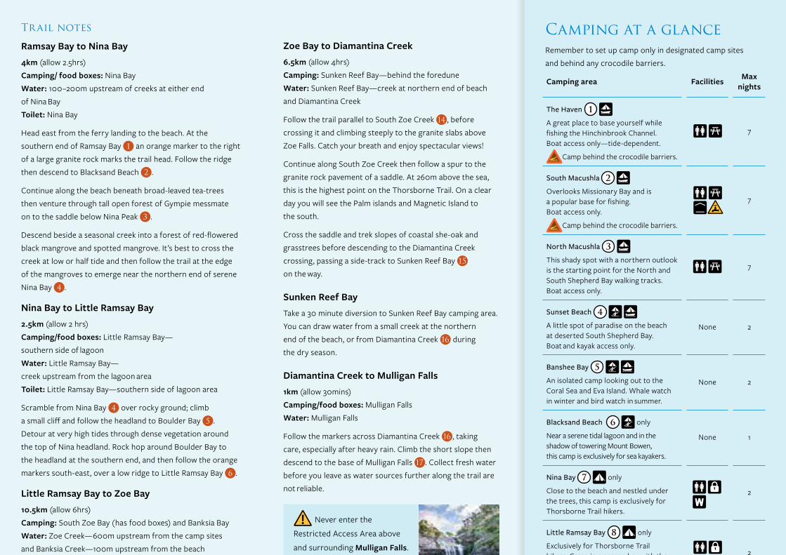
Camping area Facilities Max nights
The Haven 1
A great place to base yourself while fishing the Hinchinbrook Channel. Boat access only—tide-dependent.
Camp behind the crocodile barriers.
7
South Macushla 2
Overlooks Missionary Bay and is a popular base for fishing. Boat access only.
Camp behind the crocodile barriers.
7
North Macushla 3
This shady spot with a northern outlook is the starting point for the North and South Shepherd Bay walking tracks. Boat access only.
7
Sunset Beach 4
A little spot of paradise on the beach at deserted South Shepherd Bay. Boat and kayak access only.
None 2
Banshee Bay 5
An isolated camp looking out to the Coral Sea and Eva Island. Whale watch in winter and bird watch in summer.
None 2
Blacksand Beach 6 only
Near a serene tidal lagoon and in the shadow of towering Mount Bowen, this camp is exclusively for sea kayakers.
None 1
Nina Bay 7 only
Close to the beach and nestled under the trees, this camp is exclusively for Thorsborne Trail hikers.
2
Little Ramsay Bay 8 only
Exclusively for Thorsborne Trail hikers. Camp in a serene bay with the dramatic backdrop of Hinchinbrook’s rugged ridgelines.
2
Banksia Bay 9
Secluded bush camp near Banksia Creek, with views of Ramsay Bay.
None2
(3 boats)
Agnes Beach 10
Offers views and privacy. To protect nesting seabirds, camp only between April and September.
None2
(3 boats)
North Zoe Bay 11
A prime fishing spot at the mouth of North Zoe Creek with unlimited beach access. Spot sea turtles feeding in the mouth of the creek.
None 2
South Zoe Bay 12
Fronts Zoe Bay’s expansive beach, with beautiful Zoe Falls a 10min walk away.
2 (3 boats)
Sunken Reef Bay 13
A shady spot 30mins walk off the Thorsborne Trail with panoramic views of the bay, Hinchinbrook’s southern mountains and the Lucinda jetty.
2
Mulligan Falls 14 only
Exclusively for Thorsborne Trail hikers near the base of the falls. Never enter the Restricted Access Area above and around of the falls—death and serious injuries have occurred here.
1
Mulligan Bay 15
Camp with views to Orpheus Island and Mount Diamantina. Explore the nearby creek lined with tall mangroves.
None 2
George Point 16
The southern transfer point for Thorsborne Trail hikers has views to Lucinda and Orpheus Island.
2
Camping at a glanceRemember to set up camp only in designated camp sites and behind any crocodile barriers.
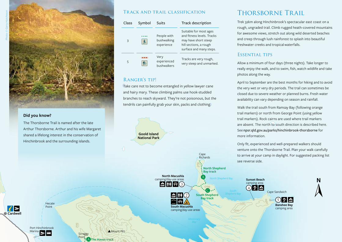
Class Symbol Suits Track description
3 People with
bushwalking experience
Suitable for most ages and fitness levels. Tracks may have short steep hill sections, a rough surface and many steps.
5 Very
experienced bushwalkers
Tracks are very rough, very steep and unmarked.
Thorsborne TrailTrek 32km along Hinchinbrook’s spectacular east coast on a rough, ungraded trail. Climb rugged heath-covered mountains for awesome views, stretch out along wild deserted beaches and creep through lush rainforest to splash into beautiful freshwater creeks and tropical waterfalls.
Essential tips
Allow a minimum of four days (three nights). Take longer to really enjoy the walk, and to swim, fish, watch wildlife and take photos along the way.
April to September are the best months for hiking and to avoid the very wet or very dry periods. The trail can sometimes be closed due to severe weather or planned burns. Fresh water availability can vary depending on season and rainfall.
Walk the trail south from Ramsay Bay (following orange trail markers) or north from George Point (using yellow trail markers). Rock cairns are used where trail markers are absent. The north to south direction is described here. See npsr.qld.gov.au/parks/hinchinbrook-thorsborne for more information.
Only fit, experienced and well-prepared walkers should venture onto the Thorsborne Trail. Plan your walk carefully to arrive at your camp in daylight. For suggested packing list
see reverse side.
Zoe Bay to Diamantina Creek6.5km (allow 4hrs) Camping: Sunken Reef Bay—behind the foredune Water: Sunken Reef Bay—creek at northern end of beach and Diamantina Creek
Follow the trail parallel to South Zoe Creek 14 , before crossing it and climbing steeply to the granite slabs above Zoe Falls. Catch your breath and enjoy spectacular views!
Continue along South Zoe Creek then follow a spur to the granite rock pavement of a saddle. At 260m above the sea, this is the highest point on the Thorsborne Trail. On a clear day you will see the Palm islands and Magnetic Island to the south.
Cross the saddle and trek slopes of coastal she-oak and grasstrees before descending to the Diamantina Creek crossing, passing a side-track to Sunken Reef Bay 15 on the way.
Sunken Reef BayTake a 30 minute diversion to Sunken Reef Bay camping area. You can draw water from a small creek at the northern end of the beach, or from Diamantina Creek 16 during the dry season.
Diamantina Creek to Mulligan Falls1km (allow 30mins) Camping/food boxes: Mulligan Falls Water: Mulligan Falls
Follow the markers across Diamantina Creek 16 , taking care, especially after heavy rain. Climb the short slope then descend to the base of Mulligan Falls 17 . Collect fresh water before you leave as water sources further along the trail are not reliable.
Listen in the rainforest for the deep ‘wallock-a-woo’ calls of the brightly coloured but elusive wompoo fruit-dove (above). Hermit crabs are hard to spot against the sand (above middle).
Keep an eye out for green turtles in the sea between Nina Bay and Boulder Bay (below).
Never enter the
Restricted Access Area above
and surrounding Mulligan Falls.
Slippery rock pavements,
including those well back from
the falls, make this area unsafe.
Serious injuries and deaths
have occurred here.
Trail notes
Ramsay Bay to Nina Bay4km (allow 2.5hrs) Camping/ food boxes: Nina Bay Water: 100–200m upstream of creeks at either end of Nina Bay Toilet: Nina Bay
Head east from the ferry landing to the beach. At the southern end of Ramsay Bay 1 an orange marker to the right of a large granite rock marks the trail head. Follow the ridge then descend to Blacksand Beach 2 .
Continue along the beach beneath broad-leaved tea-trees then venture through tall open forest of Gympie messmate on to the saddle below Nina Peak 3 .
Descend beside a seasonal creek into a forest of red-flowered black mangrove and spotted mangrove. It’s best to cross the creek at low or half tide and then follow the trail at the edge of the mangroves to emerge near the northern end of serene Nina Bay 4 .
Nina Bay to Little Ramsay Bay2.5km (allow 2 hrs) Camping/food boxes: Little Ramsay Bay— southern side of lagoon Water: Little Ramsay Bay— creek upstream from the lagoon area Toilet: Little Ramsay Bay—southern side of lagoon area
Scramble from Nina Bay 4 over rocky ground; climb a small cliff and follow the headland to Boulder Bay 5 . Detour at very high tides through dense vegetation around the top of Nina headland. Rock hop around Boulder Bay to the headland at the southern end, and then follow the orange markers south-east, over a low ridge to Little Ramsay Bay 6 .
Little Ramsay Bay to Zoe Bay10.5km (allow 6hrs) Camping: South Zoe Bay (has food boxes) and Banksia Bay Water: Zoe Creek—600m upstream from the camp sites and Banksia Creek—100m upstream from the beach Toilet: Zoe Bay—southern end
Trek south from Little Ramsay Bay 6 , cross a tidal creek and rock hop around the headland to the next beach. Head to and then along another beach before veering south-east through a small gully to the top of a ridge.
Here, you can take a side path to Banksia Bay 7 (600m return) and a small camping area where golden orchids grow on beach-side rocks.
Following the main trail south, cross Banksia Creek to the saddle between Banksia and Zoe bays. Descend from the saddle into a rocky creek and continue south-south-west through dry open forest, rainforest and mangrove swamps to North Zoe Creek 9 .
Trudge through palm swamps and tall rainforest to Fan Palm Creek 10 . The trail is hard to see so look carefully for trail markers.
Refill water containers at Fan Palm Creek 10 or Cypress Pine Creek 11 and prepare to wet your feet at creek crossings and swampy sections hiking to Zoe Bay 12 . The mouth of South Zoe Creek is about 400m to the south.
Cool off in the pool at the base of Zoe Falls 13 , 450m from South Zoe Bay camping area. Curious jungle perch will swim up to you if you sit quietly in the shadows and yabbies will nibble on your toes.
Mulligan Falls to George Point7.5km (allow 2.5hrs) Camping/food boxes: George Point— southern end of Mulligan Bay Toilet: George Point
Follow the coast, travelling through rainforest then crossing five creeks. About 300m south of the Diamantina Creek inlet a sign indicates the northern entrance to Mulligan Bay 18 .
Stroll 2km along the beach to Mulligan Creek 19 , cross it at low to half tide, and then 3kms further on is George Point 20 and the southern end of the trail.
Did you know?
The Thorsborne Trail is named after the late
Arthur Thorsborne. Arthur and his wife Margaret
shared a lifelong interest in the conservation of
Hinchinbrook and the surrounding islands.
Photo (above): © Bruce ThomsonPhoto (above middle): Adam Creed © Qld Govt
Photo (below): © Qld GovtPhoto (right): Emma Schmidt © Qld Govt
Photo (far right): © Garry Hutcheson
Phot
o: ©
Gar
ry H
utch
eson
Ranger’s tip!Take care not to become entangled in yellow lawyer cane
and hairy mary. These climbing palms use hook-studded
branches to reach skyward. They’re not poisonous, but the
tendrils can painfully grab your skin, packs and clothing.
Phot
o: ©
Gar
ry H
utch
eson
Track and trail classification
100
200
500
400
300
600
700
800
1000
100
300100
100
400
100
100
800
300
300
600
600
500
700
100
100
400
100
800
300
500
600
700
400
200
200
500
500
100
400
200
600
700
400
200
200
400
700
300
400
100
800
Nina Baycamping area
The Havencamping/day-use areas
Banshee Baycamping area
Agnes beachcamping area
Banksia Baycamping area
Sunset Beachcamping area
George Pointcamping/day-use areas
Mulligan Baycamping area
North Zoe Baycamping area
South Zoe Baycamping/day-use areas
ZoeFalls
Mulligan Fallscamping area
North Macushlacamping/day-use areas
South Macushlacamping/day-use areas
Sunken Reef Bay camping area
Blacksand Beach camping area (sea kayaks only)
Little Ramsay Baycamping area
Diamantina Creek
Mul
ligan
Cre
ek
South
Zoe Creek
Cardwell
Mount Pitt
Mt Burnett
Mt Straloch
ScraggyPoint
The Haven track
Mt Diamantina
Hinchinbrook Channel
Port HinchinbrookMarina
Hinchinbrook IslandNational Park
GirringunNational Park
Lucinda
Dungeness
PicnicBeach
HillockPoint
HaycockIsland
North Zoe Creek
Fan P
almCr
eek
Banksia
Creek
Cypress Pine Creek
Zoe Bay
Thorsborne Bay
Nina Bay
Mt BowenThe Thumb
Nina Peak
North Shepherd Bay
SouthShepherd Bay Cape Sandwich
MissionaryBay
CapeRichards
HecatePoint
North ShepherdBay track
South ShepherdBay track
Goold IslandNational Park
Ramsay Bay
Bruce Highway
8
2
4
9
5
10
11
12
13
15
14
16
7
6
3
1
A
3 4
5
6
7
8
910
11 12
14
1617
15
18
19
20
13
2
C
A
B
1
5 10kmScale0
Legend
National park
Land
Water
Waterways
Ferry route
Contour lines
Sealed road
Walking track
Track identifier
Thorsborne Trail
Trail note
Camping area
Mountain
Information
Parking
Boat ramp
Ferry
Toilets
Day-use area
Shelter
Picnic table
Food box
Thorsborne Trail hikers camping
Boat camping
Sea kayak camping
Water collection point
Water—treat before drinking
1
1
Camping area Facilities Max nights
The Haven 1
A great place to base yourself while fishing the Hinchinbrook Channel. Boat access only—tide-dependent.
Camp behind the crocodile barriers.
7
South Macushla 2
Overlooks Missionary Bay and is a popular base for fishing. Boat access only.
Camp behind the crocodile barriers.
7
North Macushla 3
This shady spot with a northern outlook is the starting point for the North and South Shepherd Bay walking tracks. Boat access only.
7
Sunset Beach 4
A little spot of paradise on the beach at deserted South Shepherd Bay. Boat and kayak access only.
None 2
Banshee Bay 5
An isolated camp looking out to the Coral Sea and Eva Island. Whale watch in winter and bird watch in summer.
None 2
Blacksand Beach 6 only
Near a serene tidal lagoon and in the shadow of towering Mount Bowen, this camp is exclusively for sea kayakers.
None 1
Nina Bay 7 only
Close to the beach and nestled under the trees, this camp is exclusively for Thorsborne Trail hikers.
2
Little Ramsay Bay 8 only
Exclusively for Thorsborne Trail hikers. Camp in a serene bay with the dramatic backdrop of Hinchinbrook’s rugged ridgelines.
2
Banksia Bay 9
Secluded bush camp near Banksia Creek, with views of Ramsay Bay.
None2
(3 boats)
Agnes Beach 10
Offers views and privacy. To protect nesting seabirds, camp only between April and September.
None2
(3 boats)
North Zoe Bay 11
A prime fishing spot at the mouth of North Zoe Creek with unlimited beach access. Spot sea turtles feeding in the mouth of the creek.
None 2
South Zoe Bay 12
Fronts Zoe Bay’s expansive beach, with beautiful Zoe Falls a 10min walk away.
2 (3 boats)
Sunken Reef Bay 13
A shady spot 30mins walk off the Thorsborne Trail with panoramic views of the bay, Hinchinbrook’s southern mountains and the Lucinda jetty.
2
Mulligan Falls 14 only
Exclusively for Thorsborne Trail hikers near the base of the falls. Never enter the Restricted Access Area above and around of the falls—death and serious injuries have occurred here.
1
Mulligan Bay 15
Camp with views to Orpheus Island and Mount Diamantina. Explore the nearby creek lined with tall mangroves.
None 2
George Point 16
The southern transfer point for Thorsborne Trail hikers has views to Lucinda and Orpheus Island.
2
Camping at a glanceRemember to set up camp only in designated camp sites and behind any crocodile barriers.
Class Symbol Suits Track description
3 People with
bushwalking experience
Suitable for most ages and fitness levels. Tracks may have short steep hill sections, a rough surface and many steps.
5 Very
experienced bushwalkers
Tracks are very rough, very steep and unmarked.
Thorsborne TrailTrek 32km along Hinchinbrook’s spectacular east coast on a rough, ungraded trail. Climb rugged heath-covered mountains for awesome views, stretch out along wild deserted beaches and creep through lush rainforest to splash into beautiful freshwater creeks and tropical waterfalls.
Essential tips
Allow a minimum of four days (three nights). Take longer to really enjoy the walk, and to swim, fish, watch wildlife and take photos along the way.
April to September are the best months for hiking and to avoid the very wet or very dry periods. The trail can sometimes be closed due to severe weather or planned burns. Fresh water availability can vary depending on season and rainfall.
Walk the trail south from Ramsay Bay (following orange trail markers) or north from George Point (using yellow trail markers). Rock cairns are used where trail markers are absent. The north to south direction is described here. See npsr.qld.gov.au/parks/hinchinbrook-thorsborne for more information.
Only fit, experienced and well-prepared walkers should venture onto the Thorsborne Trail. Plan your walk carefully to arrive at your camp in daylight. For suggested packing list
see reverse side.
Zoe Bay to Diamantina Creek6.5km (allow 4hrs) Camping: Sunken Reef Bay—behind the foredune Water: Sunken Reef Bay—creek at northern end of beach and Diamantina Creek
Follow the trail parallel to South Zoe Creek 14 , before crossing it and climbing steeply to the granite slabs above Zoe Falls. Catch your breath and enjoy spectacular views!
Continue along South Zoe Creek then follow a spur to the granite rock pavement of a saddle. At 260m above the sea, this is the highest point on the Thorsborne Trail. On a clear day you will see the Palm islands and Magnetic Island to the south.
Cross the saddle and trek slopes of coastal she-oak and grasstrees before descending to the Diamantina Creek crossing, passing a side-track to Sunken Reef Bay 15 on the way.
Sunken Reef BayTake a 30 minute diversion to Sunken Reef Bay camping area. You can draw water from a small creek at the northern end of the beach, or from Diamantina Creek 16 during the dry season.
Diamantina Creek to Mulligan Falls1km (allow 30mins) Camping/food boxes: Mulligan Falls Water: Mulligan Falls
Follow the markers across Diamantina Creek 16 , taking care, especially after heavy rain. Climb the short slope then descend to the base of Mulligan Falls 17 . Collect fresh water before you leave as water sources further along the trail are not reliable.
Listen in the rainforest for the deep ‘wallock-a-woo’ calls of the brightly coloured but elusive wompoo fruit-dove (above). Hermit crabs are hard to spot against the sand (above middle).
Keep an eye out for green turtles in the sea between Nina Bay and Boulder Bay (below).
Never enter the
Restricted Access Area above
and surrounding Mulligan Falls.
Slippery rock pavements,
including those well back from
the falls, make this area unsafe.
Serious injuries and deaths
have occurred here.
Trail notes
Ramsay Bay to Nina Bay4km (allow 2.5hrs) Camping/ food boxes: Nina Bay Water: 100–200m upstream of creeks at either end of Nina Bay Toilet: Nina Bay
Head east from the ferry landing to the beach. At the southern end of Ramsay Bay 1 an orange marker to the right of a large granite rock marks the trail head. Follow the ridge then descend to Blacksand Beach 2 .
Continue along the beach beneath broad-leaved tea-trees then venture through tall open forest of Gympie messmate on to the saddle below Nina Peak 3 .
Descend beside a seasonal creek into a forest of red-flowered black mangrove and spotted mangrove. It’s best to cross the creek at low or half tide and then follow the trail at the edge of the mangroves to emerge near the northern end of serene Nina Bay 4 .
Nina Bay to Little Ramsay Bay2.5km (allow 2 hrs) Camping/food boxes: Little Ramsay Bay— southern side of lagoon Water: Little Ramsay Bay— creek upstream from the lagoon area Toilet: Little Ramsay Bay—southern side of lagoon area
Scramble from Nina Bay 4 over rocky ground; climb a small cliff and follow the headland to Boulder Bay 5 . Detour at very high tides through dense vegetation around the top of Nina headland. Rock hop around Boulder Bay to the headland at the southern end, and then follow the orange markers south-east, over a low ridge to Little Ramsay Bay 6 .
Little Ramsay Bay to Zoe Bay10.5km (allow 6hrs) Camping: South Zoe Bay (has food boxes) and Banksia Bay Water: Zoe Creek—600m upstream from the camp sites and Banksia Creek—100m upstream from the beach Toilet: Zoe Bay—southern end
Trek south from Little Ramsay Bay 6 , cross a tidal creek and rock hop around the headland to the next beach. Head to and then along another beach before veering south-east through a small gully to the top of a ridge.
Here, you can take a side path to Banksia Bay 7 (600m return) and a small camping area where golden orchids grow on beach-side rocks.
Following the main trail south, cross Banksia Creek to the saddle between Banksia and Zoe bays. Descend from the saddle into a rocky creek and continue south-south-west through dry open forest, rainforest and mangrove swamps to North Zoe Creek 9 .
Trudge through palm swamps and tall rainforest to Fan Palm Creek 10 . The trail is hard to see so look carefully for trail markers.
Refill water containers at Fan Palm Creek 10 or Cypress Pine Creek 11 and prepare to wet your feet at creek crossings and swampy sections hiking to Zoe Bay 12 . The mouth of South Zoe Creek is about 400m to the south.
Cool off in the pool at the base of Zoe Falls 13 , 450m from South Zoe Bay camping area. Curious jungle perch will swim up to you if you sit quietly in the shadows and yabbies will nibble on your toes.
Mulligan Falls to George Point7.5km (allow 2.5hrs) Camping/food boxes: George Point— southern end of Mulligan Bay Toilet: George Point
Follow the coast, travelling through rainforest then crossing five creeks. About 300m south of the Diamantina Creek inlet a sign indicates the northern entrance to Mulligan Bay 18 .
Stroll 2km along the beach to Mulligan Creek 19 , cross it at low to half tide, and then 3kms further on is George Point 20 and the southern end of the trail.
Did you know?
The Thorsborne Trail is named after the late
Arthur Thorsborne. Arthur and his wife Margaret
shared a lifelong interest in the conservation of
Hinchinbrook and the surrounding islands.
Photo (above): © Bruce ThomsonPhoto (above middle): Adam Creed © Qld Govt
Photo (below): © Qld GovtPhoto (right): Emma Schmidt © Qld Govt
Photo (far right): © Garry Hutcheson
Phot
o: ©
Gar
ry H
utch
eson
Ranger’s tip!Take care not to become entangled in yellow lawyer cane
and hairy mary. These climbing palms use hook-studded
branches to reach skyward. They’re not poisonous, but the
tendrils can painfully grab your skin, packs and clothing.
Phot
o: ©
Gar
ry H
utch
eson
Track and trail classification

100
200
500
400
300
600
700
800
1000
100
300100
100
400
100
100
800
300
300
600
600
500
700
100
100
400
100
800
300
500
600
700
400
200
200
500
500
100
400
200
600
700
400
200
200
400
700
300
400
100
800
Nina Baycamping area
The Havencamping/day-use areas
Banshee Baycamping area
Agnes beachcamping area
Banksia Baycamping area
Sunset Beachcamping area
George Pointcamping/day-use areas
Mulligan Baycamping area
North Zoe Baycamping area
South Zoe Baycamping/day-use areas
ZoeFalls
Mulligan Fallscamping area
North Macushlacamping/day-use areas
South Macushlacamping/day-use areas
Sunken Reef Bay camping area
Blacksand Beach camping area (sea kayaks only)
Little Ramsay Baycamping area
Diamantina Creek
Mul
ligan
Cre
ek
South
Zoe Creek
Cardwell
Mount Pitt
Mt Burnett
Mt Straloch
ScraggyPoint
The Haven track
Mt Diamantina
Hinchinbrook Channel
Port HinchinbrookMarina
Hinchinbrook IslandNational Park
GirringunNational Park
Lucinda
Dungeness
PicnicBeach
HillockPoint
HaycockIsland
North Zoe Creek
Fan P
almCr
eek
Banksia
Creek
Cypress Pine Creek
Zoe Bay
Thorsborne Bay
Nina Bay
Mt BowenThe Thumb
Nina Peak
North Shepherd Bay
SouthShepherd Bay Cape Sandwich
MissionaryBay
CapeRichards
HecatePoint
North ShepherdBay track
South ShepherdBay track
Goold IslandNational Park
Ramsay Bay
Bruce Highway
8
2
4
9
5
10
11
12
13
15
14
16
7
6
3
1
A
3 4
5
6
7
8
910
11 12
14
1617
15
18
19
20
13
2
C
A
B
1
5 10kmScale0
Legend
National park
Land
Water
Waterways
Ferry route
Contour lines
Sealed road
Walking track
Track identifier
Thorsborne Trail
Trail note
Camping area
Mountain
Information
Parking
Boat ramp
Ferry
Toilets
Day-use area
Shelter
Picnic table
Food box
Thorsborne Trail hikers camping
Boat camping
Sea kayak camping
Water collection point
Water—treat before drinking
1
1
Camping area Facilities Max nights
The Haven 1
A great place to base yourself while fishing the Hinchinbrook Channel. Boat access only—tide-dependent.
Camp behind the crocodile barriers.
7
South Macushla 2
Overlooks Missionary Bay and is a popular base for fishing. Boat access only.
Camp behind the crocodile barriers.
7
North Macushla 3
This shady spot with a northern outlook is the starting point for the North and South Shepherd Bay walking tracks. Boat access only.
7
Sunset Beach 4
A little spot of paradise on the beach at deserted South Shepherd Bay. Boat and kayak access only.
None 2
Banshee Bay 5
An isolated camp looking out to the Coral Sea and Eva Island. Whale watch in winter and bird watch in summer.
None 2
Blacksand Beach 6 only
Near a serene tidal lagoon and in the shadow of towering Mount Bowen, this camp is exclusively for sea kayakers.
None 1
Nina Bay 7 only
Close to the beach and nestled under the trees, this camp is exclusively for Thorsborne Trail hikers.
2
Little Ramsay Bay 8 only
Exclusively for Thorsborne Trail hikers. Camp in a serene bay with the dramatic backdrop of Hinchinbrook’s rugged ridgelines.
2
Banksia Bay 9
Secluded bush camp near Banksia Creek, with views of Ramsay Bay.
None2
(3 boats)
Agnes Beach 10
Offers views and privacy. To protect nesting seabirds, camp only between April and September.
None2
(3 boats)
North Zoe Bay 11
A prime fishing spot at the mouth of North Zoe Creek with unlimited beach access. Spot sea turtles feeding in the mouth of the creek.
None 2
South Zoe Bay 12
Fronts Zoe Bay’s expansive beach, with beautiful Zoe Falls a 10min walk away.
2 (3 boats)
Sunken Reef Bay 13
A shady spot 30mins walk off the Thorsborne Trail with panoramic views of the bay, Hinchinbrook’s southern mountains and the Lucinda jetty.
2
Mulligan Falls 14 only
Exclusively for Thorsborne Trail hikers near the base of the falls. Never enter the Restricted Access Area above and around of the falls—death and serious injuries have occurred here.
1
Mulligan Bay 15
Camp with views to Orpheus Island and Mount Diamantina. Explore the nearby creek lined with tall mangroves.
None 2
George Point 16
The southern transfer point for Thorsborne Trail hikers has views to Lucinda and Orpheus Island.
2
Camping at a glanceRemember to set up camp only in designated camp sites and behind any crocodile barriers.
Class Symbol Suits Track description
3 People with
bushwalking experience
Suitable for most ages and fitness levels. Tracks may have short steep hill sections, a rough surface and many steps.
5 Very
experienced bushwalkers
Tracks are very rough, very steep and unmarked.
Thorsborne TrailTrek 32km along Hinchinbrook’s spectacular east coast on a rough, ungraded trail. Climb rugged heath-covered mountains for awesome views, stretch out along wild deserted beaches and creep through lush rainforest to splash into beautiful freshwater creeks and tropical waterfalls.
Essential tips
Allow a minimum of four days (three nights). Take longer to really enjoy the walk, and to swim, fish, watch wildlife and take photos along the way.
April to September are the best months for hiking and to avoid the very wet or very dry periods. The trail can sometimes be closed due to severe weather or planned burns. Fresh water availability can vary depending on season and rainfall.
Walk the trail south from Ramsay Bay (following orange trail markers) or north from George Point (using yellow trail markers). Rock cairns are used where trail markers are absent. The north to south direction is described here. See npsr.qld.gov.au/parks/hinchinbrook-thorsborne for more information.
Only fit, experienced and well-prepared walkers should venture onto the Thorsborne Trail. Plan your walk carefully to arrive at your camp in daylight. For suggested packing list
see reverse side.
Zoe Bay to Diamantina Creek6.5km (allow 4hrs) Camping: Sunken Reef Bay—behind the foredune Water: Sunken Reef Bay—creek at northern end of beach and Diamantina Creek
Follow the trail parallel to South Zoe Creek 14 , before crossing it and climbing steeply to the granite slabs above Zoe Falls. Catch your breath and enjoy spectacular views!
Continue along South Zoe Creek then follow a spur to the granite rock pavement of a saddle. At 260m above the sea, this is the highest point on the Thorsborne Trail. On a clear day you will see the Palm islands and Magnetic Island to the south.
Cross the saddle and trek slopes of coastal she-oak and grasstrees before descending to the Diamantina Creek crossing, passing a side-track to Sunken Reef Bay 15 on the way.
Sunken Reef BayTake a 30 minute diversion to Sunken Reef Bay camping area. You can draw water from a small creek at the northern end of the beach, or from Diamantina Creek 16 during the dry season.
Diamantina Creek to Mulligan Falls1km (allow 30mins) Camping/food boxes: Mulligan Falls Water: Mulligan Falls
Follow the markers across Diamantina Creek 16 , taking care, especially after heavy rain. Climb the short slope then descend to the base of Mulligan Falls 17 . Collect fresh water before you leave as water sources further along the trail are not reliable.
Listen in the rainforest for the deep ‘wallock-a-woo’ calls of the brightly coloured but elusive wompoo fruit-dove (above). Hermit crabs are hard to spot against the sand (above middle).
Keep an eye out for green turtles in the sea between Nina Bay and Boulder Bay (below).
Never enter the
Restricted Access Area above
and surrounding Mulligan Falls.
Slippery rock pavements,
including those well back from
the falls, make this area unsafe.
Serious injuries and deaths
have occurred here.
Trail notes
Ramsay Bay to Nina Bay4km (allow 2.5hrs) Camping/ food boxes: Nina Bay Water: 100–200m upstream of creeks at either end of Nina Bay Toilet: Nina Bay
Head east from the ferry landing to the beach. At the southern end of Ramsay Bay 1 an orange marker to the right of a large granite rock marks the trail head. Follow the ridge then descend to Blacksand Beach 2 .
Continue along the beach beneath broad-leaved tea-trees then venture through tall open forest of Gympie messmate on to the saddle below Nina Peak 3 .
Descend beside a seasonal creek into a forest of red-flowered black mangrove and spotted mangrove. It’s best to cross the creek at low or half tide and then follow the trail at the edge of the mangroves to emerge near the northern end of serene Nina Bay 4 .
Nina Bay to Little Ramsay Bay2.5km (allow 2 hrs) Camping/food boxes: Little Ramsay Bay— southern side of lagoon Water: Little Ramsay Bay— creek upstream from the lagoon area Toilet: Little Ramsay Bay—southern side of lagoon area
Scramble from Nina Bay 4 over rocky ground; climb a small cliff and follow the headland to Boulder Bay 5 . Detour at very high tides through dense vegetation around the top of Nina headland. Rock hop around Boulder Bay to the headland at the southern end, and then follow the orange markers south-east, over a low ridge to Little Ramsay Bay 6 .
Little Ramsay Bay to Zoe Bay10.5km (allow 6hrs) Camping: South Zoe Bay (has food boxes) and Banksia Bay Water: Zoe Creek—600m upstream from the camp sites and Banksia Creek—100m upstream from the beach Toilet: Zoe Bay—southern end
Trek south from Little Ramsay Bay 6 , cross a tidal creek and rock hop around the headland to the next beach. Head to and then along another beach before veering south-east through a small gully to the top of a ridge.
Here, you can take a side path to Banksia Bay 7 (600m return) and a small camping area where golden orchids grow on beach-side rocks.
Following the main trail south, cross Banksia Creek to the saddle between Banksia and Zoe bays. Descend from the saddle into a rocky creek and continue south-south-west through dry open forest, rainforest and mangrove swamps to North Zoe Creek 9 .
Trudge through palm swamps and tall rainforest to Fan Palm Creek 10 . The trail is hard to see so look carefully for trail markers.
Refill water containers at Fan Palm Creek 10 or Cypress Pine Creek 11 and prepare to wet your feet at creek crossings and swampy sections hiking to Zoe Bay 12 . The mouth of South Zoe Creek is about 400m to the south.
Cool off in the pool at the base of Zoe Falls 13 , 450m from South Zoe Bay camping area. Curious jungle perch will swim up to you if you sit quietly in the shadows and yabbies will nibble on your toes.
Mulligan Falls to George Point7.5km (allow 2.5hrs) Camping/food boxes: George Point— southern end of Mulligan Bay Toilet: George Point
Follow the coast, travelling through rainforest then crossing five creeks. About 300m south of the Diamantina Creek inlet a sign indicates the northern entrance to Mulligan Bay 18 .
Stroll 2km along the beach to Mulligan Creek 19 , cross it at low to half tide, and then 3kms further on is George Point 20 and the southern end of the trail.
Did you know?
The Thorsborne Trail is named after the late
Arthur Thorsborne. Arthur and his wife Margaret
shared a lifelong interest in the conservation of
Hinchinbrook and the surrounding islands.
Photo (above): © Bruce ThomsonPhoto (above middle): Adam Creed © Qld Govt
Photo (below): © Qld GovtPhoto (right): Emma Schmidt © Qld Govt
Photo (far right): © Garry Hutcheson
Phot
o: ©
Gar
ry H
utch
eson
Ranger’s tip!Take care not to become entangled in yellow lawyer cane
and hairy mary. These climbing palms use hook-studded
branches to reach skyward. They’re not poisonous, but the
tendrils can painfully grab your skin, packs and clothing.
Phot
o: ©
Gar
ry H
utch
eson
Track and trail classification