historic river road
TRANSCRIPT

HISTORICRiver Road
Your journey begins at the start sign on WAVERLY just EAST of U.S.31. Bring a friend and a picnic. Spend an hour or the day. Let your car become a time machine.
A Self-Guided Auto Tour for all Seasons
$3.00
Each Journey Begins With a Single Step: Historic River Road and the Self-Guided Auto Tour for All Seasons were conceived by local historian Marjorie Bethke Viveen. After considerable research, in 2008 Viveen submitted a formal proposal to the Ottawa County Parks Commission, believing the Historic River Road concept nicely complemented the Parks' broader initiative for the Grand River Greenway. The original plan for the road was endorsed and in 2011 was expanded to encompass all activities of the Grand River Greenway Parks Celebration 2012 Committee chaired by Viveen. Included were over a dozen special events, a 24-part speaker series, and two permanent projects: the Memory Grove at Eastmanville Farm County Park and Historic River Road. Because River Road traversed across local governments, jurisdictions, and interests, it was imperative to coordinate efforts. Ottawa County Parks wishes to thank the following organizations for their generous support of the Historic River Road project:
The Drake Middlemist Heritage Fund
Administered by the Grand Haven Area Community Foundation
The Drake Middlemist Heritage Fund was established on behalf of Dr. William Depue Drake in 2004 fulfilling his wishes to leave a legacy for the benefit of local historians.
An annual award is made to a person or persons who undertake specific projects in the areas of local historical research, oral history, or education. These projects must be focused on the historic background of the people, places, and events that are a part of the Tri-Cities' legacy. The grants may include financial support for training, travel, and research, and they may be used to provide funds for presentations, exhibits, purchase of artifacts, and other similar expenses that support the work of the Drake Middlemist Heritage Fund award recipient.

HISTORIC RIVER ROAD
Following the contours of today's Grand River Greenway in north Ottawa County, Historic River Road defines the progression of our regional civilization. Long ago, mastodon, giant beaver, bison, and other prehistoric beasts tramped paths along the banks of the Grand River. Seeking food and other resources, Paleo-man followed these same pathways. Later Potawatomie and Ottawa Indians established camps and villages, about a day's hike from each other, to form the Grand River Trail that spanned the state. Using that base, the federal government in 1837 laid the “United States Road from Detroit to the Mouth of the Grand River” (Grand River Avenue). Funding for that project dried up short of the West Michigan coast, yet the planned route can be seen in the original plat of the Wadsworth Addition to the City of Grand Haven. The old two-track bisected what is now the YMCA.
Meanwhile, in the townships, lumbermen turned that two-track into tramways that delivered logs to the river. The corridor matured. “River Road to Grand Rapids” appeared on an 1854 map of Grand Haven. Clear-cut land was prepared for agriculture and logging tracks became farm-to- market roads.
By the 1870s, the beauty of fruit blossoms and bayous lured greater numbers of tourists, creating a cottage and resort boom that fuels our economy yet today. By the early 1950s, local politicians had segmented River Road into essentially Waverly, Mercury, Green, North Cedar, and Warner on the south side of the river and Leonard Road on the north. The original River Road is the oldest byway in Ottawa County and one of the oldest in the state. Historic River Road transports us across time and space.
We hope you enjoy the ride.
See Center Map River RoadHISTORIC30Old Light House Enter the Fisherman's Parking Lot off Harbor Avenue.
Grand Haven's first lighthouse, likely located where you're parked, was undermined by erosion, and a new lighthouse was built opposite the entrance to this lot. It is a privately owned cottage today. Earlier on this tour, you “met” Captain “Harry Bluff” Miller at Eastmanville Cemetery and again at the old Poor Farm. When Captain Miller ended his career on the Great Lakes, he and his second wife, Mary, became keepers of this light. Harry died in 1876, making Mary Miller the first and only female lighthouse keeper in Grand Haven. To learn more about the history of the channel and existing lighthouse, we encourage you to stroll the boardwalk and pier, where interpretive signs all along the shore tell the history. This ends your journey along Historic River Road. We hope you’ve enjoyed the ride and will share this booklet with another “time traveler.”
Image courtesy of Dr. Wallace Ewing
Parking available

River RoadGidley Bayou Prior to the settlement of Grand Haven in 1834, this was the site of Chief Saginaw-Coosco's village. Gidley Bayou was named for Townsend Gidley, who in 1835 became the youngest member of the Michigan Constitutional Convention and went on to serve in the Michigan House and Senate for the next 32 years. He was the Whig candidate for Governor in 1851. Gidley moved to Grand Haven in 1867, purchased 2000 acres of land, and planted 20,000 fruit trees, mostly peaches. Nearly 150 years later, we still call this area “Peach Plains.”
129Road From Detroit
Harbor Avenue at Escanaba Park was the terminus of the Grand River Indian Trail, the proposed “Road from Detroit to the Mouth of the Grand River,” and is nearly the end of your Historic River Road tour. All routes would have bisected today's YMCA property. At that site Indians once received payments for having ceded their land to the federal government. Alfred Bennett, a black man, purchased the property in 1856. “Bennett's Hollow” became “Mulligan's Hollow,” a name that stuck when tugboat captain John Mulligan bought the parcel in the 1880s. The City of Grand Haven paid Mulligan $100.65 for the land in 1908.
Excerpt from Virgil Bennett's obituary Grand Haven Tribune 6 Nov. 1915
Bennett’s/Mulligan’s HollowCourtesy of Dr. Wallace Ewing
"United States Road from Detroit to the Mouth of the Grand River"Ottawa Co. liber #1, p. 6, 1837, Wadsworth Addition GH
Parking availableImage courtesy of Library of Michigan
HISTORIC

Driving Park The track was located on the site now occupied by the subdivision to your left. Townsend Gidley and his lumbermen cronies in 1874 established the Grand Haven Trotting Park and Agricultural Association. At a time when harness racing challenged baseball as the national pastime, the “Driving Park,” as it was known, hosted nationally ranked horses including Bodine seen here. A regional economic crisis doomed the enterprise almost from the beginning. To stay afloat, Gidley sold a 123-acre riverfront parcel to George Aiken (cover), the one-time South Pacific whaler and ship's cook who farmed the land.
2
1876 plat map showingthe Driving Park.
Image courtesy of Robert Beaton Aerial photo of the Driving Park takenbefore 1929. Courtesy of USDA - Grand Haven
River Road27
28
Coal Tipple Exit Linear Park and continue on Harbor Island Drive Street Bridge to Jackson Street where you will turn right.
The imposing concrete structure you see before you is a coal tipple. Steam engines servicing Grand Haven needed fuel to operate. Hopper cars loaded with coal positioned themselves under the tipple's arches and emptied their load into a deep pit beneath the rails. Coal stored there was conveyed to the storage vault at the top of the tower where, as needed, gravity carried the fuel down chutes into an engine's tender. Just ahead is Steam Engine 1223, once used for hauling freight between Chicago, Saginaw, Detroit, and Toledo, it was brought to Grand Haven in 1981 and restored by local train buffs.
Trading Post After following the curve, Jackson Street becomes Harbor Drive. Proceed to the corner of Harbor Drive and Washington Avenue, an excellent place to start exploring on foot.
over the Third
This is the original site of Rix Robinson's fur trading post and warehouse dating to 1821. Robinson supplied over twenty posts from the Traverse Bay area to St. Joseph, but this and the Ada post were central to his business. Though William Ferry was credited with being the founder of Grand Haven, it was Rix Robinson and Robert Stuart who laid the groundwork for Ferry's move from Mackinac Island. While on this site, visit the Tri-Cities Historical Museum's Transportation annex, follow the brass course of the Grand River on the sidewalk, attend an event at Waterfront Stadium, enjoy the Musical Fountain, and stroll the famous Boardwalk.
Rix RobinsonPhoto courtesy of
Michigan Archives
Parking available at both sites
HISTORIC

River RoadPotawatomie Bayou After Aiken committed suicide in 1916, dairy farmer Harry Deremo bought the property. He supplemented his income by clamming on Potawatomie Bayou. The unionids were harvested, boiled, shelled, and the rare pearls were sold to jewelers on Pearl Street in Grand Rapids for as much as $10 each. The shells went to local button factories and the clam meat was fed to livestock.
Located just across Potawatomie Bridge on the river side was Germania Park. From about 1900 to 1919, the steamer May Graham and all other imaginable conveyances brought hundreds of picnickers here to enjoy the fully equipped kitchen, band shell, ball field, shaded benches, and each other's company. The park crumbled under anti-German sentiment during WWI and was sold into private ownership for $1 and other considerations.
Deremo clammingPhoto courtesy of Esther Green
Doris Salisbury at Germania ParkPhoto courtesy of
Tri-Cities Historical Museum
326KKK on Dewey Hill Turn into Linear Park, and park in the designated area. Take the short walk to the viewing deck at Linear Park.
From this vantage point you can see Dewey Hill. In 1923 the Ku Klux Klan boasted 160 local members. Headlines in the September 17, 1923 edition of the Grand Haven Tribune read, Fiery Cross Burns Here on Hilltop and went on to state that:
The Klan has come to Grand Haven t’was in the mouth of every Havenite Saturday night with the first burning of the fiery cross, emblem of the Klan, that was witnessed on Dewey Hill across the harbor at Grand Haven. The sudden growth of the Klan has been astonishing and many laws have been enacted to work against their secret meetings and practice of wearing hoods and masks.
Enthusiasm for the Klan died after 1925. The ad from a local clothing store below was found in the July 20, 1917 edition of the Grand Haven Tribune. The KKK association was anything but subtle.
Image courtesy of Grand Haven Tribune
Parking available
HISTORIC

River Road25Charles Langlade Exit Mill Point Park on School Street which connects to Savidge. Head west and follow signage to Grand Haven via U.S.31 south, stay right. Turn right on Coho Drive.
It is impossible to say where specifically, but in 1754 Charles Langlade established a fur trading post in this general area. Langlade was awarded exclusive trading rights on the Grand River for the heroic role he played in the French Indian War, aided by Ottawa Indians he personally recruited from along the Grand. Despite having been on the losing side of that conflict and being reprimanded when his troops killed, butchered, boiled, and ate a Miami Indian chief, Langlade maintained his status. He oversaw seasonal operations here from 1754 through at least 1791, when explorer Hugh Heward recorded their meeting in his famous journal. Here Charles Langlade is pictured on a commemorative coin issued by Langlade County in Wisconsin.
C. Langlade's house as seen at Fort Michilimackinac Photo courtesy of Mackinac State Historic Parks
Millhouse Bayou Bridge In the 1860s, a man named Somerset was returning from Grand Haven to his home near Millhouse Bayou when he heard a sound that horrified him. A pack of hungry wolves was tracking his scent. To distract the animals, Somerset tossed a package he had been carrying and rushed to where he knew a boat was moored. Somerset rowed to safety as night fell.
Over time, rudimentary bridges were built at that site. When the War Department disallowed structures that filled the channel between the Grand River and Millhouse Bayou, a float bridge was constructed. By 1907, wind, weather, and rot deteriorated that span. Improvements thereafter were thwarted by marl and sand on the bridge, requiring cars to get a running start when attempting the crossing. After countless problems, a new bridge was completed in 1915.
Photos courtesy of Ottawa County Road Commission
4 HISTORIC

River RoadOdawa/Battle Point Launch By June 30, 1883, unrelenting rains had engorged the Grand River. Eighty million feet of logs were catapulted downstream along with the remnants of several Grand Rapids bridges. If booms designed to manage the logs failed, allowing logs to escape into Lake Michigan, it would have meant certain economic disaster for the entire region. Lewis Cross captured the drama of the log jam in his painting of the Ottawa County Boom Company's makeshift swing used to channel rampaging logs into Stearns Bayou just east of this site. The quick-thinking strategy saved the day and possibly our future as a community.
Log Jam of 1883 painted by Lewis Cross.
5
Parking available
24Mill Point Park Turn left on School Street to enter Mill Point Park.
What is now Mill Point Park and Spring Lake's newly opened Grand River Greenway Walk, in 1870 was the site of the Cutler & Savidge Lumber Company covering the entire west end of Mill Point (SL). Employing up to 500 men seasonally, Cutler & Savidge was one of the largest, most productive mills in the world during the lumbering era. By the 1880s the Grand River Valley was logged out. Hunter Savidge, a well-respected community leader, died in 1881. Dwight Cutler went on to invest in resort properties serving early tourists to this area.
Parking available
Photo courtesy of Spring Lake District Library
HISTORIC

Felix's Marina Elfrieda Schultz and Felix Pytlinski wed in 1923 and purchased land on Stearns Bayou. They opened a boat rental business with a single vessel crafted by Felix. Their first customer, a bulky YMCA instructor, sank the tiny boat. Undeterred, Felix built four more and launched anew on July 4, 1929, the same day ten people drowned at the Grand Haven State Park in a seiche, exacerbating the gloom of the Depression. The couple persevered, eventually developing a marina, dance hall, gas station, and store.
Pictured is Elfrieda Pytlinske, wife of Felix, Sr., promoting fishing on Stearn's Bayou. Image courtesy of Felix Pytlinske, Jr.
6 River Road23Windsor McKay/Barber School Follow Bayou Drive around to charming Boom Road. Turn left and enjoy this scenic interlude, that in the 1870s would have
ndbeen clogged with logs. Take 152 to return to Leonard Road. Head west.Leonard will become Pinewood as you cross the bayou.Turn right on to S. Lake Avenue, then turn left at the stoplight onto River Street.Turn right at Meridian Avenue at Exchange Street and turn left onto Exchange.
Near the corner of Meridian and Exchange, just steps west of the Spring Lake District Library, you will find a Michigan Historical Marker honoring artist/cartoonist Winsor McKay. You are encouraged to read the plaque and peruse the library for details of McKay's interesting life and stunning images of his playful work.
Continuing west on Exchange just one block and you'll see the Barber School Community Building. Built in 1855, Barber School has had a long journey. In 1873 the building was purchased by Hunter Savidge and moved from the SE corner of Park and Liberty Streets to the Cutler and Savidge Lumber Mill, where it was used as a warehouse and later as the Spring Lake Yacht Club. In 1987 the SL Heritage League moved the structure to its present location. Today Barber School is used for Village Council meetings, community functions, and private gatherings.
Windsor McKayPhotos courtesy of Spring Lake District Library
Parking available
Bridge photo courtesy of Ottawa County Road Commision
In 1899 Robinson Township Supervisor, Charles Stearns was contracted to convert the original floating bridge over Stearns Bayou to a permanent structure. He staked the floating bridge with logs to secure its position and filled the bridge bed with sand.
HISTORIC
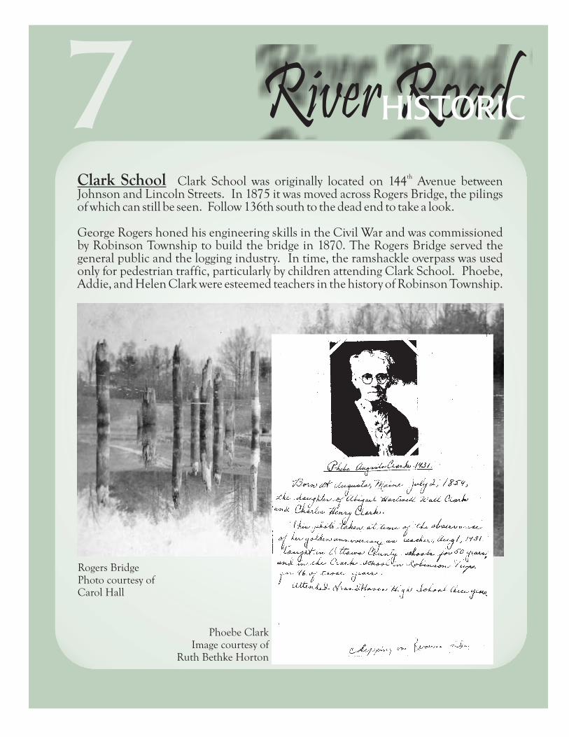
River RoadthClark School Clark School was originally located on 144 Avenue between
Johnson and Lincoln Streets. In 1875 it was moved across Rogers Bridge, the pilings of which can still be seen. Follow 136th south to the dead end to take a look.
George Rogers honed his engineering skills in the Civil War and was commissioned by Robinson Township to build the bridge in 1870. The Rogers Bridge served the general public and the logging industry. In time, the ramshackle overpass was used only for pedestrian traffic, particularly by children attending Clark School. Phoebe, Addie, and Helen Clark were esteemed teachers in the history of Robinson Township.
Rogers Bridge Photo courtesy ofCarol Hall
Phoebe ClarkImage courtesy of
Ruth Bethke Horton
722Lewis Cross
thReturn to Leonard Road. Drive west to 144 Avenue south.
thAt 144 Avenue and Bayou Drive is a privately owned residence that was originally the home of painter, naturalist, and historian Lewis Cross. Known as “The Castle,” the building blocks of this unique abode were molded by Cross himself. The home overlooked a floating bridge spanning Deremo Bayou, as seen in this image painted by Cross. It is one of over 400 landscape, marine, and portrait pictures created by this modest, self-reliant man. Some are as large as 8' by11' and many depict carrier pigeons that long ago swarmed the Grand River Valley, but are now extinct. Old and sick, Lewis Cross committed suicide on April 4, 1951.
Lewis Cross, Self portraitand paintings
HISTORIC

Connor Bayou County Park This park is named for Jared Connor who settled here in 1837. The land was sold to William Ferry in 1849 for purposes of logging and eventually was divided into riverfront parcels owned by Matthew Krumpeck and teacher Addie Clark. Long before Ottawa County conceived this area as parkland, Krumpeck and his neighbor Waldron hosted huge annual North Robinson Farmer Co-Operative Association Picnics here starting in 1917. Organizers bragged that River Road was “one of the best in Ottawa County” and the grounds offered “splendid places for landing launches”….just like today!
Waldron, Krumpeck, and Clark properties shown along the Grand River.
8
Parking available
River Road20
21
Images courtesy of Kevin Finney
Parking available at both sites
Bruce Bayou East Bruce Bayou was named for one-time Crockery Township Supervisor, William Bruce, who served from 1861-1863. He was a successful farmer and operated a sawmill at this location. After his death in 1892, the site became a riverboat landing. The sidewheeler May Graham made stops here from 1907-1918 carrying fruit, clam shells to the button factories, and passengers traveling from Grand Rapids to Grand Haven.
Indian Channel and Battle Point From Bruce Bayou return to Leonard Road via 132nd. Travel west to 138th Avenue and follow its zigzagging course all the way back to the very end, where you will find Indian Channel and Battle Point.
Battle Point was the site of Fort Village and an Ottawa Indian burial ground. Research done by GVSU, MSU, Martin/Mainfort, and others suggest that the cemetery was used between 1820 and 1835. The Washington Treaty of 1836 ceded all land north of the Grand River to the United States. Enraged at the prospect, Chief Shiawassee attempted to induce tribesmen here to revolt and massacre the whites. Rev. William Ferry and Indian friends successfully defused the threat. No blood was shed at “Battle Point.” Numerous trade goods, including knives, firesteels, silver ornaments, and glass beads, were found in excavations here, but the area has since been seriously undermined by erosion.
HISTORIC

River RoadRobinson Township Cemetery Stroll here to find Ransom Robinson's burial site. The son of township founder Ira Robinson and nephew to Rix Robinson, Ransom was a true pioneer. At eighteen months of age, he was likely the youngest passenger aboard the schooner St. Joseph that transported 42 Robinson family members from New York to Grand Haven in 1836. In 1862 Ransom enlisted
stin Co. G of the 21 Michigan Infantry and joined General “Sherman's Bummers.” He was discharged just six months later with tuberculosis. Though hardships of the war left their mark on him, Ransom farmed for 45 years before his death in 1920. Look here too, for the graves of Clark, Rogers, Stearns, and Cordes family members.
Ransom RobinsonPhoto courtesy of David Robinson
9
Parking available
19Crockery Creek Natural Area From Leonard Road, turn left on Wren Drive and travel one-half mile. You will come upon the Kirkby Centennial Farm, now owned by Ottawa County Parks. The various buildings are representative of agrarian living. Read more about it at the kiosk.
This is the site of the Ottawa Indian village where Magdalene, daughter of Jean Bapiste Marcotte and Timothee (daughter of Chief Returning Cloud) was raised and where fur trader Joseph LaFramboise had one of numerous posts. The two wed when she was fourteen. Madame Magdalene LaFramboise took over the entire trade in 1806 after Joseph was brutally murdered by an Indian denied alcohol. Upon her retirement in 1821, Rix Robinson bought the business. Madame LaFramboise was celebrated for her ability to bridge cultural gaps that separated people by gender, religion, and race. She was one of the first inducted into the Michigan History Women's Hall of Fame.
Image courtesy of Kevin FinneyMadame Magdalene LaFramboise. Paintedfrom descriptions of her. Artist unknown
Parking available
Return to Leonard Road, turn left and proceed west to 132nd. Turn left and follow 132nd to the end.
HISTORIC

JacJungle Between 1930 and 1951, a wonderfully notorious dance hall and tavern was located on what is now the Southern Grand Marina property. Chicago-born Al Cordes played piano in vaudeville acts before establishing JacJungle, named by combining Al's initials with his wife, Julia's. The couple brought live music, novel floor shows, food, drink, and merriment to the rural setting. Kate Smith and George Goebel are believed to have started their show business careers here. The party ended in 1951 when JacJungle burned to the ground. Then owner George Graham moved his business to Lake Michigan Drive, where he built the Embassy Bar.
Visit Riverside County Park next door to the old JacJungle site.
JacJunglePhoto courtesy of Barbara Nelson
Al and Julia CordesPhoto courtesy of Robinson Township
Performers at JacJunglePhoto courtesy of Robinson Township
JacJunglePhoto courtesy of Robinson Township
10 River Road18Jubb Bayou Retrace your route back to Leonard Road. Turn left onto Leonard and drive one block. Turn left onto Oriole. Curve to the right and follow the gravel road. Note the Historic Ottawa Center Cemetery on your left, where members of the Jubb family are interred.
Jubb Bayou (a.k.a. Spoonville Bayou) is named for Edward and Moline Jubb who settled here in 1850. Their son Orange sacrificed a leg in the Civil War and is buried at the Ottawa Center Cemetery you just passed.
Members of the Anthropology Department at Grand Valley State University in 1991 unearthed a rare “Hi-Lo” projectile point in this area. It was dated to 8,000 to 10,000 B.C., and was used during the Paleo-Indian period when mastodons grazed beside the Grand River.
Exit Jubb Bayou Open Space by turning left onto Oriole. The curve to the right will place you on 104th Avenue. Follow it to Leonard then turn left.
Parking available
HISTORIC

River RoadVillage of Bass River Park at the dead end of North Cedar Dive. Exit your vehicle, take in the panoramic view and try to imagine the bustling settlement that once was here. In 1837, land speculators created Warren City, at least on a plat map and county commissioners actually passed a resolution making this “paper city” the county seat! When commissioners continued to hold meetings in more conveniently located Grand Haven, plans for Warren City dissolved. Yet, slowly people moved into the area, and eventually formed the Village of Bass River. River Road ran through its center. Two stores, a church, post office, school, boarding house, ferry dock, and many homes flanked it. By 1940, gravel mining, which began in the 1880s had consumed the entire village. Only Bass River’s watery grave remains. Today the surrounding property is state owned and designated as the Bass River Recreation Area.
Return to the tour by retracing the route to Oakley Store, located at North Cedar Drive and 104th Avenue. Turn left onto 104th. About ½ mile on your left, note the entrance to Bass River Recreation Area. Continue south on 104th. Turn left onto Osborn, which will become Warner Avenue at the bend. Turn left onto 90th. Park at the end, where gravel deteriorates into a two-track. Walk 50 yards curving to the left.
11
Parking available
16Eastmanville Farm County Park The first white men to occupy this land were Daniel Realy and Captain Henry “Harry Bluff” Miller. In 1866 they sold the property to Ottawa County for purposes of a Poor Farm. Over time the place became known as the County Farm, Infirmary, and Community Haven, serving those who were unable to live independently. Stop here to tour the Memory Grove and enjoy a short hike to the Poor Farm Cemetery. Picnic and equestrian facilities are available onsite.
Bur Oak Landing This Ottawa County Park property is divided into two parcels. From Leonard Road, parking for East Bur Oak Landing is located on the east
th thside of 90 Avenue. Parking for West Bur Oak Landing is found near the end of 90 Avenue. There you will find a spectacular example of a bur oak tree and its frilly acorns.
1Parking available at both sites
Photo courtesy of Jean Harter
Photo courtesy of Ottawa County Records7
HISTORIC

River Road Bridge You are viewing the Bass River and its flood plain. Observe the abutments that once anchored the River Road Bridge. You can almost hear the bridge rattling under the weight of Model T’s, farm wagons, and children late for school.
The span was a lifeline to the people of Bass River seeking supplies and social ties in nearby Allendale. When the Village of Bass River was undermined by the gravel company, and its population diminished, there was no need for the old, increasingly unsafe bridge. It was removed by the Ottawa County Road Commission in 1984.
Retrace your way to Warner Avenue and turn left.
Photo courtesy of Jim Ponshair
12 River RoadEastmanville Cemetery After crossing the Eastmanville Bridge, turn left on to Leonard Road (Historic River Road north). Travel one block. Turn right on to Church Street to the Eastmanville Cemetery on your right.
The oldest grave here is said to be that of little Henry Miller, son of Elizabeth and Captain Henry “Harry Bluff” Miller. Henry was born in 1838, one year after the Miller and Realy families preempted land just west of here on what eventually became the Ottawa County Poor Farm, your next stop. Only six years old, Henry died on Valentine's Day in 1844. Realy family graves also found here include Daniel, his wife Lucinda, an infant, and children Henry P., Elodon, Freddie, and Francis.
Henry Miller, Jr. Headstone (Background) Photo courtesy of Marjorie Viveen
15
Parking available
HISTORIC

River RoadEnos Parrish 17 April 1902, Grand Haven Tribune, Obituary:Enos Parrish, a pioneer resident of Ottawa County, and veteran of both the Mexican and Civil Wars, died at his home in Allendale yesterday aged nearly 80 years. Up to the time of his death, Mr. Parrish was one of the few surviving veterans of the Mexican War in this section. He served in both wars in the U.S. Artillery and gained a record as a gallant soldier. He cleared up his farm out in the wilderness and had a nice place south of River Road in Allendale.
This 1864 plat map shows the Parrish property located at what is today Warner Avenue (see “17”) just east of 90th. Both roads were links of the old River Road. Note Parrish School on the SE corner of his property (on map).
Follow Warner Avenue east to the stoplight at 68th. Turn left and watch for Eastmanville Bayou Open Space ahead on the left.
13Eastmanville Bayou Open Space Stop here to enjoy a picnic, hike, fishing, or the universally accessible kayak launch! Interpretive signs expand on the history there.
Headline Coopersville Observer, 22 June 1917THE BRIDGE IS DONE, NOW FOR SOME FUN
The Band Will Play, for Your Delight; Just Hike Out There And See The Sight
On Tuesday next, we'll ride or walk, to Eastmanville without a balk. Down on the Grand, just south of here; there is where we'll go and shout and cheer. To see the bridge, made out of steel, that spans the Grand - - how proud we feel. We'll take a lunch, and hitch up Bess, or take our Ford – we must confess – to take us there to see the fun, stay until the sport are done. Old Dick'll be there, that grand old man, to tell us all about the span. And Rogers, too, of statewide fame, he'll add his mite with loud acclaim. The county men, both road and town, will grace the scene with their renown. Plenty of fun and sports galore, and prizes too, for those who score. So plan to come, we'll treat you fine, the coffee's free for those who dine. The business men of Coopersville, will greet you all; come take your fill.
Photo courtesy of Ottawa County Road Commission
14
Parking available
HISTORIC

River Road Bridge You are viewing the Bass River and its flood plain. Observe the abutments that once anchored the River Road Bridge. You can almost hear the bridge rattling under the weight of Model T’s, farm wagons, and children late for school.
The span was a lifeline to the people of Bass River seeking supplies and social ties in nearby Allendale. When the Village of Bass River was undermined by the gravel company, and its population diminished, there was no need for the old, increasingly unsafe bridge. It was removed by the Ottawa County Road Commission in 1984.
Retrace your way to Warner Avenue and turn left.
Photo courtesy of Jim Ponshair
12 River RoadEastmanville Cemetery After crossing the Eastmanville Bridge, turn left on to Leonard Road (Historic River Road north). Travel one block. Turn right on to Church Street to the Eastmanville Cemetery on your right.
The oldest grave here is said to be that of little Henry Miller, son of Elizabeth and Captain Henry “Harry Bluff” Miller. Henry was born in 1838, one year after the Miller and Realy families preempted land just west of here on what eventually became the Ottawa County Poor Farm, your next stop. Only six years old, Henry died on Valentine's Day in 1844. Realy family graves also found here include Daniel, his wife Lucinda, an infant, and children Henry P., Elodon, Freddie, and Francis.
Henry Miller, Jr. Headstone (Background) Photo courtesy of Marjorie Viveen
15
Parking available
HISTORIC

River RoadVillage of Bass River Park at the dead end of North Cedar Dive. Exit your vehicle, take in the panoramic view and try to imagine the bustling settlement that once was here. In 1837, land speculators created Warren City, at least on a plat map and county commissioners actually passed a resolution making this “paper city” the county seat! When commissioners continued to hold meetings in more conveniently located Grand Haven, plans for Warren City dissolved. Yet, slowly people moved into the area, and eventually formed the Village of Bass River. River Road ran through its center. Two stores, a church, post office, school, boarding house, ferry dock, and many homes flanked it. By 1940, gravel mining, which began in the 1880s had consumed the entire village. Only Bass River’s watery grave remains. Today the surrounding property is state owned and designated as the Bass River Recreation Area.
Return to the tour by retracing the route to Oakley Store, located at North Cedar Drive and 104th Avenue. Turn left onto 104th. About ½ mile on your left, note the entrance to Bass River Recreation Area. Continue south on 104th. Turn left onto Osborn, which will become Warner Avenue at the bend. Turn left onto 90th. Park at the end, where gravel deteriorates into a two-track. Walk 50 yards curving to the left.
11
Parking available
16Eastmanville Farm County Park The first white men to occupy this land were Daniel Realy and Captain Henry “Harry Bluff” Miller. In 1866 they sold the property to Ottawa County for purposes of a Poor Farm. Over time the place became known as the County Farm, Infirmary, and Community Haven, serving those who were unable to live independently. Stop here to tour the Memory Grove and enjoy a short hike to the Poor Farm Cemetery. Picnic and equestrian facilities are available onsite.
Bur Oak Landing This Ottawa County Park property is divided into two parcels. From Leonard Road, parking for East Bur Oak Landing is located on the east
th thside of 90 Avenue. Parking for West Bur Oak Landing is found near the end of 90 Avenue. There you will find a spectacular example of a bur oak tree and its frilly acorns.
1Parking available at both sites
Photo courtesy of Jean Harter
Photo courtesy of Ottawa County Records7
HISTORIC

JacJungle Between 1930 and 1951, a wonderfully notorious dance hall and tavern was located on what is now the Southern Grand Marina property. Chicago-born Al Cordes played piano in vaudeville acts before establishing JacJungle, named by combining Al's initials with his wife, Julia's. The couple brought live music, novel floor shows, food, drink, and merriment to the rural setting. Kate Smith and George Goebel are believed to have started their show business careers here. The party ended in 1951 when JacJungle burned to the ground. Then owner George Graham moved his business to Lake Michigan Drive, where he built the Embassy Bar.
Visit Riverside County Park next door to the old JacJungle site.
JacJunglePhoto courtesy of Barbara Nelson
Al and Julia CordesPhoto courtesy of Robinson Township
Performers at JacJunglePhoto courtesy of Robinson Township
JacJunglePhoto courtesy of Robinson Township
10 River Road18Jubb Bayou Retrace your route back to Leonard Road. Turn left onto Leonard and drive one block. Turn left onto Oriole. Curve to the right and follow the gravel road. Note the Historic Ottawa Center Cemetery on your left, where members of the Jubb family are interred.
Jubb Bayou (a.k.a. Spoonville Bayou) is named for Edward and Moline Jubb who settled here in 1850. Their son Orange sacrificed a leg in the Civil War and is buried at the Ottawa Center Cemetery you just passed.
Members of the Anthropology Department at Grand Valley State University in 1991 unearthed a rare “Hi-Lo” projectile point in this area. It was dated to 8,000 to 10,000 B.C., and was used during the Paleo-Indian period when mastodons grazed beside the Grand River.
Exit Jubb Bayou Open Space by turning left onto Oriole. The curve to the right will place you on 104th Avenue. Follow it to Leonard then turn left.
Parking available
HISTORIC

River RoadRobinson Township Cemetery Stroll here to find Ransom Robinson's burial site. The son of township founder Ira Robinson and nephew to Rix Robinson, Ransom was a true pioneer. At eighteen months of age, he was likely the youngest passenger aboard the schooner St. Joseph that transported 42 Robinson family members from New York to Grand Haven in 1836. In 1862 Ransom enlisted
stin Co. G of the 21 Michigan Infantry and joined General “Sherman's Bummers.” He was discharged just six months later with tuberculosis. Though hardships of the war left their mark on him, Ransom farmed for 45 years before his death in 1920. Look here too, for the graves of Clark, Rogers, Stearns, and Cordes family members.
Ransom RobinsonPhoto courtesy of David Robinson
9
Parking available
19Crockery Creek Natural Area From Leonard Road, turn left on Wren Drive and travel one-half mile. You will come upon the Kirkby Centennial Farm, now owned by Ottawa County Parks. The various buildings are representative of agrarian living. Read more about it at the kiosk.
This is the site of the Ottawa Indian village where Magdalene, daughter of Jean Bapiste Marcotte and Timothee (daughter of Chief Returning Cloud) was raised and where fur trader Joseph LaFramboise had one of numerous posts. The two wed when she was fourteen. Madame Magdalene LaFramboise took over the entire trade in 1806 after Joseph was brutally murdered by an Indian denied alcohol. Upon her retirement in 1821, Rix Robinson bought the business. Madame LaFramboise was celebrated for her ability to bridge cultural gaps that separated people by gender, religion, and race. She was one of the first inducted into the Michigan History Women's Hall of Fame.
Image courtesy of Kevin FinneyMadame Magdalene LaFramboise. Paintedfrom descriptions of her. Artist unknown
Parking available
Return to Leonard Road, turn left and proceed west to 132nd. Turn left and follow 132nd to the end.
HISTORIC

Connor Bayou County Park This park is named for Jared Connor who settled here in 1837. The land was sold to William Ferry in 1849 for purposes of logging and eventually was divided into riverfront parcels owned by Matthew Krumpeck and teacher Addie Clark. Long before Ottawa County conceived this area as parkland, Krumpeck and his neighbor Waldron hosted huge annual North Robinson Farmer Co-Operative Association Picnics here starting in 1917. Organizers bragged that River Road was “one of the best in Ottawa County” and the grounds offered “splendid places for landing launches”….just like today!
Waldron, Krumpeck, and Clark properties shown along the Grand River.
8
Parking available
River Road20
21
Images courtesy of Kevin Finney
Parking available at both sites
Bruce Bayou East Bruce Bayou was named for one-time Crockery Township Supervisor, William Bruce, who served from 1861-1863. He was a successful farmer and operated a sawmill at this location. After his death in 1892, the site became a riverboat landing. The sidewheeler May Graham made stops here from 1907-1918 carrying fruit, clam shells to the button factories, and passengers traveling from Grand Rapids to Grand Haven.
Indian Channel and Battle Point From Bruce Bayou return to Leonard Road via 132nd. Travel west to 138th Avenue and follow its zigzagging course all the way back to the very end, where you will find Indian Channel and Battle Point.
Battle Point was the site of Fort Village and an Ottawa Indian burial ground. Research done by GVSU, MSU, Martin/Mainfort, and others suggest that the cemetery was used between 1820 and 1835. The Washington Treaty of 1836 ceded all land north of the Grand River to the United States. Enraged at the prospect, Chief Shiawassee attempted to induce tribesmen here to revolt and massacre the whites. Rev. William Ferry and Indian friends successfully defused the threat. No blood was shed at “Battle Point.” Numerous trade goods, including knives, firesteels, silver ornaments, and glass beads, were found in excavations here, but the area has since been seriously undermined by erosion.
HISTORIC

River RoadthClark School Clark School was originally located on 144 Avenue between
Johnson and Lincoln Streets. In 1875 it was moved across Rogers Bridge, the pilings of which can still be seen. Follow 136th south to the dead end to take a look.
George Rogers honed his engineering skills in the Civil War and was commissioned by Robinson Township to build the bridge in 1870. The Rogers Bridge served the general public and the logging industry. In time, the ramshackle overpass was used only for pedestrian traffic, particularly by children attending Clark School. Phoebe, Addie, and Helen Clark were esteemed teachers in the history of Robinson Township.
Rogers Bridge Photo courtesy ofCarol Hall
Phoebe ClarkImage courtesy of
Ruth Bethke Horton
722Lewis Cross
thReturn to Leonard Road. Drive west to 144 Avenue south.
thAt 144 Avenue and Bayou Drive is a privately owned residence that was originally the home of painter, naturalist, and historian Lewis Cross. Known as “The Castle,” the building blocks of this unique abode were molded by Cross himself. The home overlooked a floating bridge spanning Deremo Bayou, as seen in this image painted by Cross. It is one of over 400 landscape, marine, and portrait pictures created by this modest, self-reliant man. Some are as large as 8' by11' and many depict carrier pigeons that long ago swarmed the Grand River Valley, but are now extinct. Old and sick, Lewis Cross committed suicide on April 4, 1951.
Lewis Cross, Self portraitand paintings
HISTORIC

Felix's Marina Elfrieda Schultz and Felix Pytlinski wed in 1923 and purchased land on Stearns Bayou. They opened a boat rental business with a single vessel crafted by Felix. Their first customer, a bulky YMCA instructor, sank the tiny boat. Undeterred, Felix built four more and launched anew on July 4, 1929, the same day ten people drowned at the Grand Haven State Park in a seiche, exacerbating the gloom of the Depression. The couple persevered, eventually developing a marina, dance hall, gas station, and store.
Pictured is Elfrieda Pytlinske, wife of Felix, Sr., promoting fishing on Stearn's Bayou. Image courtesy of Felix Pytlinske, Jr.
6 River Road23Windsor McKay/Barber School Follow Bayou Drive around to charming Boom Road. Turn left and enjoy this scenic interlude, that in the 1870s would have
ndbeen clogged with logs. Take 152 to return to Leonard Road. Head west.Leonard will become Pinewood as you cross the bayou.Turn right on to S. Lake Avenue, then turn left at the stoplight onto River Street.Turn right at Meridian Avenue at Exchange Street and turn left onto Exchange.
Near the corner of Meridian and Exchange, just steps west of the Spring Lake District Library, you will find a Michigan Historical Marker honoring artist/cartoonist Winsor McKay. You are encouraged to read the plaque and peruse the library for details of McKay's interesting life and stunning images of his playful work.
Continuing west on Exchange just one block and you'll see the Barber School Community Building. Built in 1855, Barber School has had a long journey. In 1873 the building was purchased by Hunter Savidge and moved from the SE corner of Park and Liberty Streets to the Cutler and Savidge Lumber Mill, where it was used as a warehouse and later as the Spring Lake Yacht Club. In 1987 the SL Heritage League moved the structure to its present location. Today Barber School is used for Village Council meetings, community functions, and private gatherings.
Windsor McKayPhotos courtesy of Spring Lake District Library
Parking available
Bridge photo courtesy of Ottawa County Road Commision
In 1899 Robinson Township Supervisor, Charles Stearns was contracted to convert the original floating bridge over Stearns Bayou to a permanent structure. He staked the floating bridge with logs to secure its position and filled the bridge bed with sand.
HISTORIC

River RoadOdawa/Battle Point Launch By June 30, 1883, unrelenting rains had engorged the Grand River. Eighty million feet of logs were catapulted downstream along with the remnants of several Grand Rapids bridges. If booms designed to manage the logs failed, allowing logs to escape into Lake Michigan, it would have meant certain economic disaster for the entire region. Lewis Cross captured the drama of the log jam in his painting of the Ottawa County Boom Company's makeshift swing used to channel rampaging logs into Stearns Bayou just east of this site. The quick-thinking strategy saved the day and possibly our future as a community.
Log Jam of 1883 painted by Lewis Cross.
5
Parking available
24Mill Point Park Turn left on School Street to enter Mill Point Park.
What is now Mill Point Park and Spring Lake's newly opened Grand River Greenway Walk, in 1870 was the site of the Cutler & Savidge Lumber Company covering the entire west end of Mill Point (SL). Employing up to 500 men seasonally, Cutler & Savidge was one of the largest, most productive mills in the world during the lumbering era. By the 1880s the Grand River Valley was logged out. Hunter Savidge, a well-respected community leader, died in 1881. Dwight Cutler went on to invest in resort properties serving early tourists to this area.
Parking available
Photo courtesy of Spring Lake District Library
HISTORIC

River Road25Charles Langlade Exit Mill Point Park on School Street which connects to Savidge. Head west and follow signage to Grand Haven via U.S.31 south, stay right. Turn right on Coho Drive.
It is impossible to say where specifically, but in 1754 Charles Langlade established a fur trading post in this general area. Langlade was awarded exclusive trading rights on the Grand River for the heroic role he played in the French Indian War, aided by Ottawa Indians he personally recruited from along the Grand. Despite having been on the losing side of that conflict and being reprimanded when his troops killed, butchered, boiled, and ate a Miami Indian chief, Langlade maintained his status. He oversaw seasonal operations here from 1754 through at least 1791, when explorer Hugh Heward recorded their meeting in his famous journal. Here Charles Langlade is pictured on a commemorative coin issued by Langlade County in Wisconsin.
C. Langlade's house as seen at Fort Michilimackinac Photo courtesy of Mackinac State Historic Parks
Millhouse Bayou Bridge In the 1860s, a man named Somerset was returning from Grand Haven to his home near Millhouse Bayou when he heard a sound that horrified him. A pack of hungry wolves was tracking his scent. To distract the animals, Somerset tossed a package he had been carrying and rushed to where he knew a boat was moored. Somerset rowed to safety as night fell.
Over time, rudimentary bridges were built at that site. When the War Department disallowed structures that filled the channel between the Grand River and Millhouse Bayou, a float bridge was constructed. By 1907, wind, weather, and rot deteriorated that span. Improvements thereafter were thwarted by marl and sand on the bridge, requiring cars to get a running start when attempting the crossing. After countless problems, a new bridge was completed in 1915.
Photos courtesy of Ottawa County Road Commission
4 HISTORIC

River RoadPotawatomie Bayou After Aiken committed suicide in 1916, dairy farmer Harry Deremo bought the property. He supplemented his income by clamming on Potawatomie Bayou. The unionids were harvested, boiled, shelled, and the rare pearls were sold to jewelers on Pearl Street in Grand Rapids for as much as $10 each. The shells went to local button factories and the clam meat was fed to livestock.
Located just across Potawatomie Bridge on the river side was Germania Park. From about 1900 to 1919, the steamer May Graham and all other imaginable conveyances brought hundreds of picnickers here to enjoy the fully equipped kitchen, band shell, ball field, shaded benches, and each other's company. The park crumbled under anti-German sentiment during WWI and was sold into private ownership for $1 and other considerations.
Deremo clammingPhoto courtesy of Esther Green
Doris Salisbury at Germania ParkPhoto courtesy of
Tri-Cities Historical Museum
326KKK on Dewey Hill Turn into Linear Park, and park in the designated area. Take the short walk to the viewing deck at Linear Park.
From this vantage point you can see Dewey Hill. In 1923 the Ku Klux Klan boasted 160 local members. Headlines in the September 17, 1923 edition of the Grand Haven Tribune read, Fiery Cross Burns Here on Hilltop and went on to state that:
The Klan has come to Grand Haven t’was in the mouth of every Havenite Saturday night with the first burning of the fiery cross, emblem of the Klan, that was witnessed on Dewey Hill across the harbor at Grand Haven. The sudden growth of the Klan has been astonishing and many laws have been enacted to work against their secret meetings and practice of wearing hoods and masks.
Enthusiasm for the Klan died after 1925. The ad from a local clothing store below was found in the July 20, 1917 edition of the Grand Haven Tribune. The KKK association was anything but subtle.
Image courtesy of Grand Haven Tribune
Parking available
HISTORIC

Driving Park The track was located on the site now occupied by the subdivision to your left. Townsend Gidley and his lumbermen cronies in 1874 established the Grand Haven Trotting Park and Agricultural Association. At a time when harness racing challenged baseball as the national pastime, the “Driving Park,” as it was known, hosted nationally ranked horses including Bodine seen here. A regional economic crisis doomed the enterprise almost from the beginning. To stay afloat, Gidley sold a 123-acre riverfront parcel to George Aiken (cover), the one-time South Pacific whaler and ship's cook who farmed the land.
2
1876 plat map showingthe Driving Park.
Image courtesy of Robert Beaton Aerial photo of the Driving Park takenbefore 1929. Courtesy of USDA - Grand Haven
River Road27
28
Coal Tipple Exit Linear Park and continue on Harbor Island Drive Street Bridge to Jackson Street where you will turn right.
The imposing concrete structure you see before you is a coal tipple. Steam engines servicing Grand Haven needed fuel to operate. Hopper cars loaded with coal positioned themselves under the tipple's arches and emptied their load into a deep pit beneath the rails. Coal stored there was conveyed to the storage vault at the top of the tower where, as needed, gravity carried the fuel down chutes into an engine's tender. Just ahead is Steam Engine 1223, once used for hauling freight between Chicago, Saginaw, Detroit, and Toledo, it was brought to Grand Haven in 1981 and restored by local train buffs.
Trading Post After following the curve, Jackson Street becomes Harbor Drive. Proceed to the corner of Harbor Drive and Washington Avenue, an excellent place to start exploring on foot.
over the Third
This is the original site of Rix Robinson's fur trading post and warehouse dating to 1821. Robinson supplied over twenty posts from the Traverse Bay area to St. Joseph, but this and the Ada post were central to his business. Though William Ferry was credited with being the founder of Grand Haven, it was Rix Robinson and Robert Stuart who laid the groundwork for Ferry's move from Mackinac Island. While on this site, visit the Tri-Cities Historical Museum's Transportation annex, follow the brass course of the Grand River on the sidewalk, attend an event at Waterfront Stadium, enjoy the Musical Fountain, and stroll the famous Boardwalk.
Rix RobinsonPhoto courtesy of
Michigan Archives
Parking available at both sites
HISTORIC

River RoadGidley Bayou Prior to the settlement of Grand Haven in 1834, this was the site of Chief Saginaw-Coosco's village. Gidley Bayou was named for Townsend Gidley, who in 1835 became the youngest member of the Michigan Constitutional Convention and went on to serve in the Michigan House and Senate for the next 32 years. He was the Whig candidate for Governor in 1851. Gidley moved to Grand Haven in 1867, purchased 2000 acres of land, and planted 20,000 fruit trees, mostly peaches. Nearly 150 years later, we still call this area “Peach Plains.”
129Road From Detroit
Harbor Avenue at Escanaba Park was the terminus of the Grand River Indian Trail, the proposed “Road from Detroit to the Mouth of the Grand River,” and is nearly the end of your Historic River Road tour. All routes would have bisected today's YMCA property. At that site Indians once received payments for having ceded their land to the federal government. Alfred Bennett, a black man, purchased the property in 1856. “Bennett's Hollow” became “Mulligan's Hollow,” a name that stuck when tugboat captain John Mulligan bought the parcel in the 1880s. The City of Grand Haven paid Mulligan $100.65 for the land in 1908.
Excerpt from Virgil Bennett's obituary Grand Haven Tribune 6 Nov. 1915
Bennett’s/Mulligan’s HollowCourtesy of Dr. Wallace Ewing
"United States Road from Detroit to the Mouth of the Grand River"Ottawa Co. liber #1, p. 6, 1837, Wadsworth Addition GH
Parking availableImage courtesy of Library of Michigan
HISTORIC

HISTORIC RIVER ROAD
Following the contours of today's Grand River Greenway in north Ottawa County, Historic River Road defines the progression of our regional civilization. Long ago, mastodon, giant beaver, bison, and other prehistoric beasts tramped paths along the banks of the Grand River. Seeking food and other resources, Paleo-man followed these same pathways. Later Potawatomie and Ottawa Indians established camps and villages, about a day's hike from each other, to form the Grand River Trail that spanned the state. Using that base, the federal government in 1837 laid the “United States Road from Detroit to the Mouth of the Grand River” (Grand River Avenue). Funding for that project dried up short of the West Michigan coast, yet the planned route can be seen in the original plat of the Wadsworth Addition to the City of Grand Haven. The old two-track bisected what is now the YMCA.
Meanwhile, in the townships, lumbermen turned that two-track into tramways that delivered logs to the river. The corridor matured. “River Road to Grand Rapids” appeared on an 1854 map of Grand Haven. Clear-cut land was prepared for agriculture and logging tracks became farm-to- market roads.
By the 1870s, the beauty of fruit blossoms and bayous lured greater numbers of tourists, creating a cottage and resort boom that fuels our economy yet today. By the early 1950s, local politicians had segmented River Road into essentially Waverly, Mercury, Green, North Cedar, and Warner on the south side of the river and Leonard Road on the north. The original River Road is the oldest byway in Ottawa County and one of the oldest in the state. Historic River Road transports us across time and space.
We hope you enjoy the ride.
See Center Map River RoadHISTORIC30Old Light House Enter the Fisherman's Parking Lot off Harbor Avenue.
Grand Haven's first lighthouse, likely located where you're parked, was undermined by erosion, and a new lighthouse was built opposite the entrance to this lot. It is a privately owned cottage today. Earlier on this tour, you “met” Captain “Harry Bluff” Miller at Eastmanville Cemetery and again at the old Poor Farm. When Captain Miller ended his career on the Great Lakes, he and his second wife, Mary, became keepers of this light. Harry died in 1876, making Mary Miller the first and only female lighthouse keeper in Grand Haven. To learn more about the history of the channel and existing lighthouse, we encourage you to stroll the boardwalk and pier, where interpretive signs all along the shore tell the history. This ends your journey along Historic River Road. We hope you’ve enjoyed the ride and will share this booklet with another “time traveler.”
Image courtesy of Dr. Wallace Ewing
Parking available

^
£¤31
£¤31
UV45
UV104
§̈96
Leonard Rd
68th
Ave
Cleveland St
Lincoln St
Lake Michigan Dr
Lake
shor
e Dr
104t
h Av
e
144t
h Av
e
Warner St
Mercury Dr
120t
h Av
e
N Cedar Dr
80th
Ave
168t
h Av
e
Green St
Comstock St
State Rd
Bass Dr
N Fr
uitp
ort R
d
N 68
th A
ve
96th
Ave
112t
h Av
e
Van Lopik Ave
State Rd 112t
h Av
e
²
HISTORIC RIVER ROAD TOUR MAP
Crockery Creek
NaturalArea
Bur OakLanding
EastmanvilleFarm
EastmanvilleBayou
JubbBayou
Bass River State
Recreation Area
Robinson Forest
ConnorBayou
Grand HavenState Park
North Ottawa Dunes
Riverside Park
Enlargement Area
Enlargement Area
Johnson St.Forest
Start Waverly Ave.
Leonard Rd
1
2
34 5 6
7 89
10
17
11
12 13
141516
18
19
20
21
22
2324
2526
27282930
Grand HavenState GameArea
Rosy Mound Natural Area
CITY OF GRAND HAVEN
VILLAGE OF SPRING LAKE
90th
Ave.
Wren Dr.
90th
Ave.
Boom Rd.
144th
Ave
138th
Ave
132n
d Ave
128th
Ave
104th
Ave
Pottawatomie Bayou
MillhouseBayou Stearns
Bayou
GRAND RIVER
Oriole Dr.
Spring Lake
Deremo Bayou
BruceBayou
Lloyd'sBayou

HISTORICRiver Road
Your journey begins at the start sign on WAVERLY just EAST of U.S.31. Bring a friend and a picnic. Spend an hour or the day. Let your car become a time machine.
A Self-Guided Auto Tour for all Seasons
$3.00
Each Journey Begins With a Single Step: Historic River Road and the Self-Guided Auto Tour for All Seasons were conceived by local historian Marjorie Bethke Viveen. After considerable research, in 2008 Viveen submitted a formal proposal to the Ottawa County Parks Commission, believing the Historic River Road concept nicely complemented the Parks' broader initiative for the Grand River Greenway. The original plan for the road was endorsed and in 2011 was expanded to encompass all activities of the Grand River Greenway Parks Celebration 2012 Committee chaired by Viveen. Included were over a dozen special events, a 24-part speaker series, and two permanent projects: the Memory Grove at Eastmanville Farm County Park and Historic River Road. Because River Road traversed across local governments, jurisdictions, and interests, it was imperative to coordinate efforts. Ottawa County Parks wishes to thank the following organizations for their generous support of the Historic River Road project:
The Drake Middlemist Heritage Fund
Administered by the Grand Haven Area Community Foundation
The Drake Middlemist Heritage Fund was established on behalf of Dr. William Depue Drake in 2004 fulfilling his wishes to leave a legacy for the benefit of local historians.
An annual award is made to a person or persons who undertake specific projects in the areas of local historical research, oral history, or education. These projects must be focused on the historic background of the people, places, and events that are a part of the Tri-Cities' legacy. The grants may include financial support for training, travel, and research, and they may be used to provide funds for presentations, exhibits, purchase of artifacts, and other similar expenses that support the work of the Drake Middlemist Heritage Fund award recipient.