hses 1ete c09.qxd 5/16/04 10:08 am page 248 section 9.1 9...
TRANSCRIPT

248 Chapter 9
9.1 Continental Drift
Reading StrategySummarizing Copy the table. Fill it in asyou read to summarize the evidence ofcontinental drift.
Key ConceptsWhat is the hypothesis ofcontinental drift?
What evidence supportedcontinental drift?
Vocabulary◆ continental drift◆ Pangaea
Will California eventually slide into the ocean? Have continentsreally drifted apart over the centuries? Early in the twentieth century,most geologists thought that the positions of the ocean basins and con-tinents were fixed. During the last few decades, however, new data havedramatically changed our understanding of how Earth works.
An Idea Before Its TimeThe idea that continents fit together like pieces ofa jigsaw puzzle came about when better worldmaps became available. Figure 1 shows the twomost obvious pieces of this jigsaw puzzle. However,little significance was given this idea until 1915,when Alfred Wegener, a German scientist, pro-posed his radical hypothesis of continental drift.
Wegener’s continental drift hypothesis statedthat the continents had once been joined to forma single supercontinent. He called this supercon-tinent Pangaea, meaning all land.
Wegener also hypothesized that about 200 mil-lion years ago Pangaea began breaking into smallercontinents. These continents then drifted to theirpresent positions, as shown on page 250. Wegenerand others collected much evidence to supportthese claims. Let’s examine their evidence.
South America
Africa
Hypothesis Evidence
a. continental puzzle
b.
c.
d. ?
?
?
ContinentalDrift
Figure 1 A Curious Fit This map shows the best fit of SouthAmerica and Africa at a depth of about 900 meters. The areaswhere continents overlap appearin brown. Inferring Why are there areas ofoverlap?
248 Chapter 9
FOCUS
Section Objectives9.1 Describe the hypothesis of
continental drift.9.2 Evaluate the evidence in
support of continental drift.9.3 Identify the main objections
to Wegener’s hypothesis ofcontinental drift.
Build VocabularyWord Forms Before students read thissection, ask them to write a sentence ortwo describing the meaning of the worddrift. Then have them write a predictionfor what they think continental driftmeans. After students read the section,have them examine their predictions anddiscuss whether their predictions mustbe changed.
Reading Strategya. continental puzzleb. matching fossilsc. matching rocks and structuresd. ancient climates
INSTRUCT
An Idea BeforeIts TimeUse VisualsFigure 1 Point out the small areas ofbrown and light blue between Africaand South America. Ask: What couldcause the brown-shaded regions ofoverlap? (accumulation of sedimentsdeposited by rivers and stretching of theplates) What do you think the lightblue areas represent? (the continentalshelf)Visual
L1
2
L2
L2
Reading Focus
1
Section 9.1
HSES_1eTE_C09.qxd 5/16/04 10:08 AM Page 248

Plate Tectonics 249
Evidence: The Continental Puzzle Wegener first thoughtthat the continents might have been joined when he noticed the sim-ilarity between the coastlines on opposite sides of the South AtlanticOcean. He used present-day shorelines to show how the continents fittogether. However, his opponents correctly argued that erosion con-tinually changes shorelines over time.
Evidence: Matching Fossils Fossil evidence for conti-nental drift includes several fossil organisms found on differentlandmasses. Wegener reasoned that these organisms could not havecrossed the vast oceans presently separating the continents. An exam-ple is Mesosaurus, an aquatic reptile whose fossil remains are limitedto eastern South America and southern Africa, as shown in Figure 2.If Mesosaurus had been able to swim well enough to cross the vastSouth Atlantic Ocean, its fossils should be more widely distributed.This is not the case. Therefore, Wegener argued, South America andAfrica must have been joined somehow.
The idea of land bridges was once the most widely accepted expla-nation for similar fossils being found on different landmasses. Mostscientists believed that during a recent glacial period, the lowering ofsea level allowed animals to cross the narrow Bering Strait betweenAsia and North America. However, if land bridges did exist betweenSouth America and Africa, their remnants should still lie below sealevel. But no signs of such land bridges have ever been found in theAtlantic Ocean.
How does the distribution of Mesosaurus fossilsprovide evidence for continental drift?
Figure 2 Location ofMesosaurus Fossils ofMesosaurus have been found onboth sides of the South Atlanticand nowhere else in the world.Fossil remains of this and otherorganisms on the continents ofAfrica and South America appearto link these landmasses at sometime in Earth’s history.
South America
Africa
Q If all the continents were oncejoined as Pangaea, what did therest of Earth look like?
A When all the continentswere together, there must alsohave been one huge ocean sur-rounding them. This ocean iscalled Panthalassa (pan = all,thalassa = sea). Today all thatremains of Panthalassa is thePacific Ocean, which has beendecreasing in size since thebreakup of Pangaea.
Evidence:Matching FossilsPurpose Students compare twogroups of fossils from two continentsto identify those fossils that are commonto both continents.
Materials 2 groups of photographs orsamples of fossils, including at least onetype of fossil found in both groups
Procedure Have students examine thetwo groups of fossils. Tell them that thetwo groups were found on differentcontinents. Ask them to identify anyfossils that were found on bothcontinents. Have students infer theimplications of this observation.
Expected Outcome Students shouldinfer that the two continents had to beconnected at some point in the pastwhen the organism in the fossil lived.Visual, Logical
L2
Plate Tectonics 249
Customize for Inclusion Students
Visually Impaired Puzzle pieces of continentscan be made out of sandpaper by gluing amap onto the back of a piece of sandpaperand cutting out the continents. This learningtool can be used by both visually impaired
students and students who learn tactilely.Remind students who use these pieces that thepiece must be held with the rough side downfor correct geographical orientation of thecontinent.
Answer to . . .
Figure 1 Areas where there are riversor streams have deposited largeamounts of sediments.
Mesosaurus occurs onlyin eastern South America
and southern Africa.
HSES_1eTE_C09.qxd 5/16/04 10:09 AM Page 249

NorthAmerica
AfricaSouthAmerica
AntarcticaAustralia
India
Europe
250 Million Years AgoPangaea consisted of all themajor continents.
200 Million Years Ago Therifting that eventually resulted inthe Atlantic Ocean occurred overan extended period of time. Thefirst rift developed betweenNorth America and Africa.
100 Million Years AgoContinued rifting of the southernlandmasses sent India on anorthward journey.
Asia
TethysSea
PA
NG
AE A
G ON
DW
A
NA L A N D
L A U R A S I A
NorthAmerican
plate
Africanplate
SouthAmerican
plate
Antarctic plate
Pacificplate
Eurasianplate50 Million Years Ago
Australia began to separatefrom Antarctica.
Present A modern map showsthat India has collided withAsia, creating the Himalayas.
Australian-Indianplate
NorthAmerica
Africa
SouthAmerica
Antarctica
Australia
India
Europe Asia
250 Chapter 9
Figure 3 Pangaea broke up gradually over aperiod of 200 million years.
A
B
C
D
E
Breakup of Pangaea
250 Chapter 9
Use VisualsFigure 3 Have students study the mapsshowing the breakup of Pangaea. Ask:In the breakup of Pangaea, whatcontinents appear to have separatedfirst? (North America and Africa) Whatocean began to form when NorthAmerica and Africa separated? (AtlanticOcean) How was India formed? (Indiabroke away from Gondwanaland. It movednorth and eventually collided with Asia.)Visual, Logical
Some students may think that thecontinents have remained in approx-imately the same positions since thebreakup of Pangaea. Make transparenciesof the five parts of Figure 3. Superimposethe transparencies two at a time to showstudents the changes. Ask students tocome up to the projection to point outchanges in the location of continentsfrom one transparency to another.Ask which continent has moved thefarthest. (Asia)Visual, Logical
L2
L1
Section 9.1 (continued)
Recently, a unique species of purple frogthat lives underground was discovered insouthwestern India. DNA analysis showed thatthe frog was related to a group of frogs thatlive only in the Seychelles Islands off the
eastern coast of Africa and almost 3000 kmacross the Indian Ocean from India. Biologiststhink that the two frog populations areadditional evidence for continental drift.
Facts and Figures
HSES_1eTE_C09.qxd 5/16/04 10:09 AM Page 250

Plate Tectonics 251
Evidence: Rock Types and Structures Anyone who hasworked a jigsaw puzzle knows that the pieces must fit together to forma clear picture. The clear picture in the continental drift puzzle is oneof matching rock types and mountain belts. If the continents existedas Pangaea, the rocks found in a particular region on one continentshould closely match in age and type those in adjacent positions onthe adjoining continent.
Rock evidence for continental drift exists in the form of sev-eral mountain belts that end at one coastline, only to reappear on alandmass across the ocean. For example, the Appalachian mountainbelt runs northeastward through the eastern United States, ending offthe coast of Newfoundland, as shown in Figure 4A. Mountains of thesame age with similar rocks and structures are found in the BritishIsles and Scandinavia. When these landmasses are fit together as inFigure 4B, the mountain chains form a nearly continuous belt.
Evidence: Ancient Climates Wegener was a meteorologist,so he was interested in obtaining data about ancient climates to sup-port continental drift. And he did find evidence for dramatic globalclimate changes. Wegener found glacial deposits showing thatbetween 220 million and 300 million years ago, ice sheets coveredlarge areas of the Southern Hemisphere. Layers of glacial till werefound in southern Africa and South America, as well as in India andAustralia. Below these beds of glacial debris lay scratched and groovedbedrock carved by the ice. In some locations, the scratches andgrooves showed that the ice had moved from what is now the sea ontoland. It is unusual for large continental glaciers to move from the sea
How does the location of mountain chains provideevidence of continental drift?
Figure 4 A The AppalachianMountains run along the easternside of North America anddisappear off the coast ofNewfoundland. Mountains thatare similar in age and structureare found in the British Isles andScandinavia. B When theselandmasses are united as Pangaea,these ancient mountain chainsform a nearly continuous belt.
EuropeGreenlandNorth
America
SouthAmerica
AppalachianMountains
Africa
Scandinavia
CaledonianMountains
BritishIsles
NorthAmerica Africa
SouthAmerica
A B
Matching Mountain Ranges
For: Links on continental drift
Visit: www.SciLinks.org
Web Code: cjn-3091
Build Science SkillsUsing Models Havestudents use a child’sjigsaw puzzle withseveral large pieces todemonstrate matching rock types andmountain belts as follows. Studentsshould put the puzzle together on apiece of cardboard. After putting ittogether, the puzzle should be coveredwith another piece of cardboard andflipped over. On the back of the puzzle,students should draw lines representinga mountain belt that extends acrossseveral puzzle pieces. Students willunderstand when the puzzle is puttogether how mountain chains formcontinuous belts across land masses.Kinesthetic, Visual
Build Reading LiteracyRefer to p. 246D which provides theguidelines for relating cause and effect.
Relate Cause and Effect Have stu-dents read the section on pp. 251–252about ancient climates as evidencefor continental drift. Ask: Why didWegener believe that the existenceof glaciers in tropical regions of theSouthern Hemisphere was evidence ofcontinental drift rather than climaticchange? (The Northern Hemispherewas once tropical, as evidenced by coaldeposits that were formed from tropicalplants. If the Northern Hemisphere hadonce been closer to the equator, theSouthern Hemisphere probably had alsobeen further south, closer to the SouthPole. It was not likely that such a largechange in climate could have taken placewithout continental drift.)Logical
L1
L2
Plate Tectonics 251
Scientists think that 200 million years ago,what is now Pennsylvania was located farthersouth, near the equator. Fossils from coal fieldsin Pennsylvania show that the plants fromwhich the coal formed had large leaf-likestructures that are typical of tropical plants.The trunks of the plants had no growth rings,
also typical of tropical plants because thereis little seasonal temperature fluctuation toproduce the rings. Scientists believe that thesefossils are evidence that Pennsylvania once hada tropical climate and was located closer to theequator.
Facts and Figures
Answer to . . .
If mountain chains canbe continued across
present-day oceans, they provideevidence that the areas were onceconnected.
Download a worksheet oncontinental drift for students tocomplete, and find additionalteacher support from NSTA SciLinks.
HSES_1eTE_C09.qxd 5/16/04 10:09 AM Page 251
252 Chapter 2
252 Chapter 9
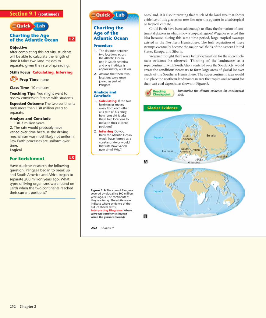
onto land. It is also interesting that much of the land area that showsevidence of this glaciation now lies near the equator in a subtropicalor tropical climate.
Could Earth have been cold enough to allow the formation of con-tinental glaciers in what is now a tropical region? Wegener rejected thisidea because, during this same time period, large tropical swampsexisted in the Northern Hemisphere. The lush vegetation of theseswamps eventually became the major coal fields of the eastern UnitedStates, Europe, and Siberia.
Wegener thought there was a better explanation for the ancient cli-mate evidence he observed. Thinking of the landmasses as asupercontinent, with South Africa centered over the South Pole, wouldcreate the conditions necessary to form large areas of glacial ice overmuch of the Southern Hemisphere. The supercontinent idea wouldalso place the northern landmasses nearer the tropics and account fortheir vast coal deposits, as shown in Figure 5.
Summarize the climate evidence for continentaldrift.
Figure 5 A The area of Pangaeacovered by glacial ice 300 millionyears ago. B The continents asthey are today. The white areasindicate where evidence of theold ice sheets exists. Interpreting Diagrams Wherewere the continents locatedwhen the glaciers formed?
Equator
NorthAmerica
Eurasia
AfricaSouthAmerica
India
Ice mass
Antarctica
Tethys Sea
Equator
Australia
Charting theAge of theAtlantic Ocean
Procedure1. The distance between
two locations acrossthe Atlantic Ocean,one in South Americaand one in Africa, isapproximately 4300 km.
2. Assume that these twolocations were oncejoined as part ofPangaea.
Analyze andConclude1. Calculating If the two
landmasses movedaway from each otherat a rate of 3.3 cm/y,how long did it takethese two locations tomove to their currentpositions?
2. Inferring Do youthink the Atlantic Oceanwould have formed at aconstant rate or wouldthat rate have variedover time? Why?
A
B
Glacier Evidence
Charting the Ageof the Atlantic Ocean
ObjectiveAfter completing this activity, studentswill be able to calculate the length oftime it takes two land masses toseparate, given the rate of spreading.
Skills Focus Calculating, Inferring
Prep Time none
Class Time 10 minutes
Teaching Tips You might want toreview conversion factors with students.
Expected Outcome The two continentstook more than 130 million years toseparate.
Analyze and Conclude1. 130.3 million years2. The rate would probably havevaried over time because the drivingmechanism was most likely not uniform.Few Earth processes are uniform overtime.Logical
For Enrichment
Have students research the followingquestion: Pangaea began to break upand South America and Africa began toseparate 200 million years ago. Whattypes of living organisms were found onEarth when the two continents reachedtheir current positions?
L3
L2
Section 9.1 (continued)
252 Chapter 2
HSES_1eTE_C09.qxd 5/16/04 10:10 AM Page 252

Section 9.1 Assessment
Rejecting a HypothesisWegener’s drift hypothesis faced a great deal of criticism from otherscientists. One objection was that Wegener could not describe a mech-anism that was capable of moving the continents across the globe.Wegener proposed that the tidal influence of the Moon was strongenough to give the continents a westward motion. However, physicistsquickly responded that tidal friction of the size needed to move thecontinents would stop Earth’s rotation.
Wegener also proposed that the larger and sturdier continentsbroke through the oceanic crust, much like ice breakers cut throughice. However, no evidence existed to suggest that the ocean floor wasweak enough to permit passage of the continents without the oceanfloors being broken and deformed in the process.
Most scientists in Wegener’s day rejected his hypothesis. However,a few geologists continued to search for additional evidence of conti-nents in motion.
A New Theory Emerges During the years that followedWegener’s hypothesis, major strides in technology enabled scientiststo map the ocean floor. Extensive data on earthquake activity andEarth’s magnetic field also became available. By 1968, these findingsled to a new theory, known as plate tectonics. This theory provides theframework for understanding most geologic processes, such as the for-mation of the mountains shown in Figure 6.
Why was Wegener’s hypothesis rejected?
Q Some day will the continentscome back together and form asingle landmass?
A Yes, but not anytime soon.Based on current plate motions,it appears that the continentsmay meet up again in thePacific Ocean—in about300 million years.
Figure 6 Mountain ranges arecommonly formed at plateboundaries. This photographshows part of the CanadianRockies in Banff National Park,Alberta, Canada.
Reviewing Concepts1. What is the hypothesis of continental
drift?
2. List the evidence that supported thehypothesis of continental drift.
3. What was one of the main objections toWegener’s continental drift hypothesis?
4. What is Pangaea?
Critical Thinking5. Applying Concepts Would the occurrence
of the same plant fossils in South America andAfrica support continental drift? Explain.
6. Drawing Conclusions How did Wegenerexplain the existence of glaciers in the southernlandmasses, and the lush tropical swamps inNorth America, Europe, and Siberia?
Descriptive Paragraph Write a para-graph describing Pangaea. Include thelocation and climate of Pangaea. Use theequator as your reference for position.
Plate Tectonics 253
Plate Tectonics 253
5. Yes, a land plant most likely could not travelacross a large ocean such as the Atlantic. Ifthe plant is found in both Africa and SouthAmerica, those areas had to have been joinedwhen the plant was growing.6. It is difficult to imagine that Earth hadcooled enough to form glaciers in tropicallatitudes, so in order to explain the glaciers,those areas had to have been closer to thepoles than in the present day. Also, the glacialgrooves indicate the ice was coming from anarea that at present is ocean. Large continentalglaciers form only on land, so that area hadto be land.
Section 9.1 Assessment
1. a hypothesis that proposes that thecontinents where once joined to formone supercontinent2. matching continental outlines, matchingfossils, matching rocks and structures, ancientclimates3. He could not provide a mechanism toexplain the movement of the continents.4. the supercontinent proposed by Wegener’shypothesis of continental drift
Rejecting aHypothesisBuild Science SkillsUsing Tables and Graphs Havestudents make a table listing the reasonswhy Wegener’s hypothesis was criticizedby some people and accepted by others.Intrapersonal, Verbal
ASSESSEvaluateUnderstandingTo assess students’ knowledge of sectioncontent, have them write two or threesentences describing each of the fourlines of evidence for Wegener’scontinental drift hypothesis.
ReteachHave students explain in their ownwords why Figure 2 shows evidencefor continental drift.
Pangaea was a supercontinent madeup of all the major continents joinedtogether. It began breaking into smallercontinents about 200 million years ago.Pangaea was located near the SouthPole. The southern part of Pangaea,made up of South America, Africa, India,Australia, and Antarctica, had a coldclimate with large continental glaciers.
L1
L2
3
L2
Answer to . . .
Figure 5 The continents were nearthe South Pole when the glaciersformed.
Glaciers in southernSouth America, southern
Africa, India, and Australia are found inareas that now have tropical climates.There is also evidence for tropicalclimates and coal swamps in areas thatare now at higher latitudes, such asnorthern Europe and the northeasternUnited States.
He could not provide amechanism for the
movement of the continents.
HSES_1eTE_C09.qxd 5/16/04 10:10 AM Page 253

9.2 Plate Tectonics
Reading StrategyComparing and Contrasting Copy thetable. After you read, compare the three typesof plate boundaries by completing the table.
Key ConceptsWhat is the theory of platetectonics?
What are lithosphericplates?
What are the three typesof plate boundaries?
Vocabulary◆ plate tectonics◆ plate◆ divergent boundary◆ convergent
boundary◆ transform fault
boundary
Earth’s Major PlatesAccording to the plate tectonics theory, the uppermost mantle,
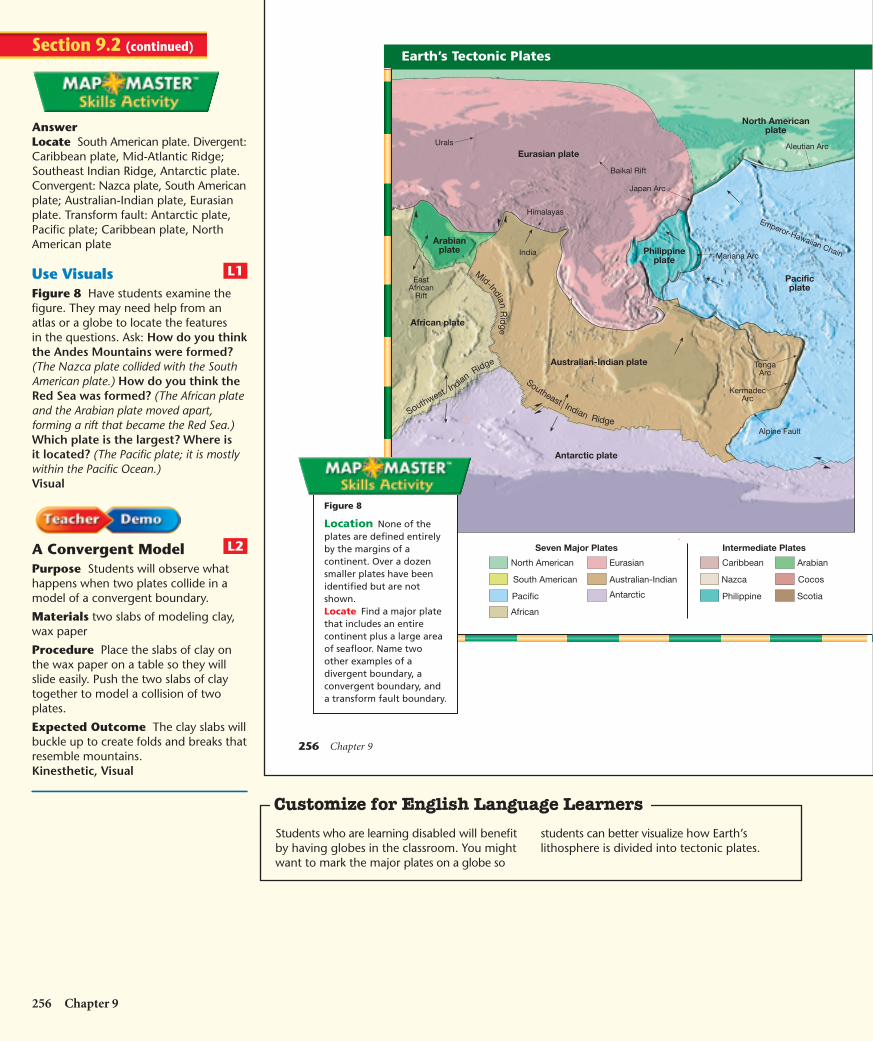
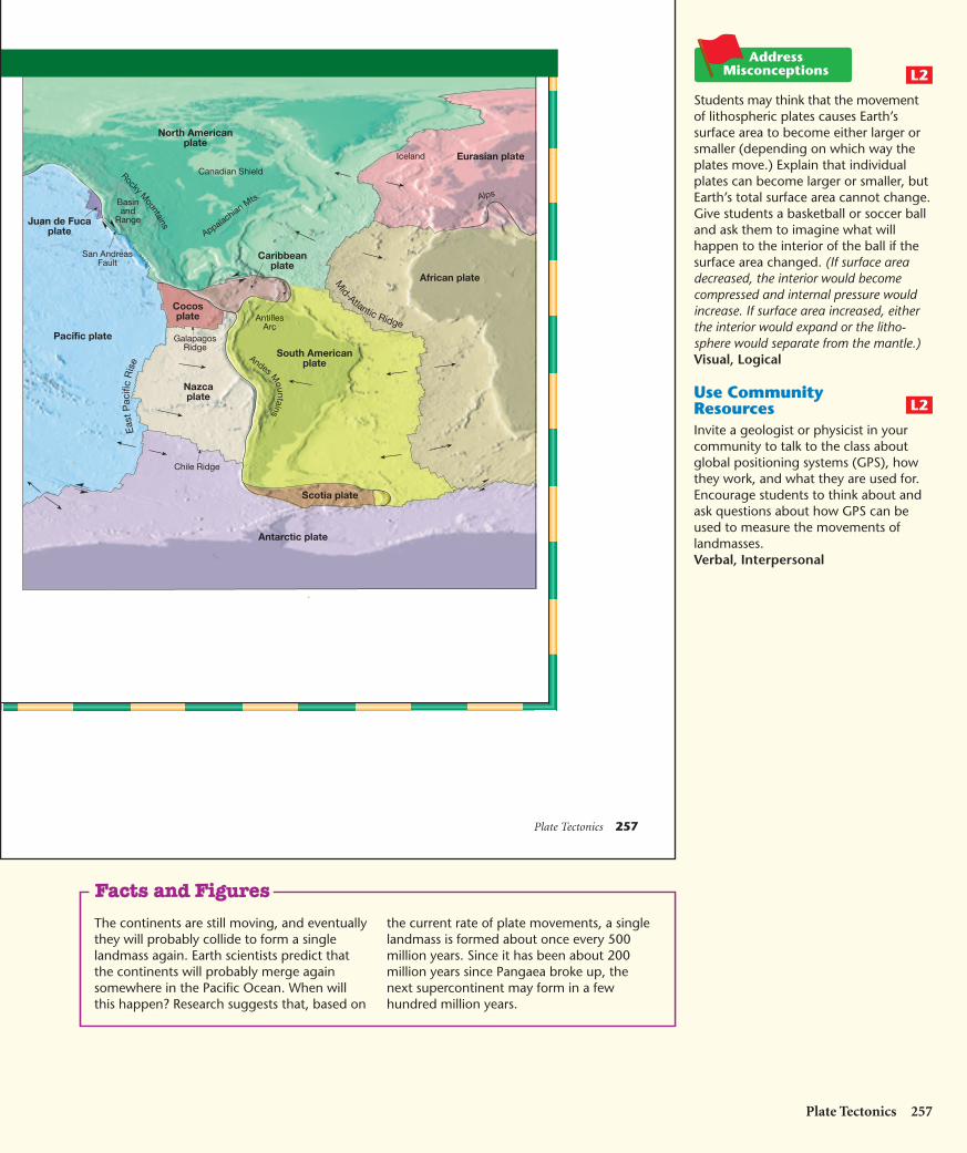
along with the overlying crust, behaves as a strong, rigid layer. Thislayer is known as the lithosphere. The outer shell lies over a weakerregion in the mantle known as the asthenosphere. The lithosphere isdivided into segments called plates, which move and continuallychange shape and size. Figure 8 on pages 256-257 shows the sevenmajor plates. The largest is the Pacific plate, covering most of thePacific Ocean. Notice that several of the large plates include an entirecontinent plus a large area of the seafloor. This is a major departurefrom Wegener’s continental drift hypothesis, which proposed that thecontinents moved through the ocean floor, not with it. Note also thatnone of the plates is defined entirely by the margins of a continent.
The lithospheric plates move relative to each other at a very slow butcontinuous rate that averages about 5 centimeters per year—about asfast as your fingernails grow. This movement is driven by the unequaldistribution of heat within Earth. Hot material found deep in the mantlemoves slowly upward as part of Earth’s internal convection system. At thesame time, cooler, denser slabs of oceanic lithosphere descend into themantle, setting Earth’s rigid outer shell into motion. The grinding move-ments of Earth’s lithospheric plates generate earthquakes, createvolcanoes, and deform large masses of rock into mountains.
What is plate tectonics?
Boundary Type Relative Plate Motion
convergent a.
divergent b.
transform fault c. ?
?
?
254 Chapter 9
254 Chapter 9
FOCUS
Section Objectives9.4 Explain the theory of plate
tectonics.9.5 Describe lithospheric plates.9.6 Identify the three types of
plate boundaries.
Build VocabularyConcept Map Have students makea concept map using the term platetectonics as the starting point. All thevocabulary terms in this section shouldbe used.
Reading Strategya. plates move togetherb. plates move apartc. plates slide past each other
INSTRUCT
Earth’s Major PlatesBuild Science SkillsUsing AnalogiesCrack the shell of ahard-boiled egg. Askstudents if the eggreminds them of anything. The egg canbe seen as a tiny model of Earth. Thethin eggshell is analogous to Earth’scrust, divided into plates. Within theshell is the firm mantle. Have studentsmove the pieces of shell around. Theyshould notice how the shell buckles insome places and exposes “mantle”in other places. This movement isanalogous to the movement of Earth’scrust. However, Earth’s movementresults in the formation of mountains,earthquakes, and new ocean floor.Kinesthetic, Visual
L2
2
L2
L2
Reading Focus
1
Section 9.2
HSES_1eTE_C09.qxd 5/16/04 10:10 AM Page 254

Divergent boundary
Convergent boundary
Transform fault boundary
Section 9.2 Assessment
Reviewing Concepts1. Define the term lithospheric plate.
2. List the three types of plate boundaries.
3. What theory proposes that Earth’s outershell consist of a number of rigid slabs?
Critical Thinking4. Comparing and Contrasting Compare
the plate motions in the three types ofboundaries.
5. Drawing Conclusions What is the majordifference in the role of the ocean floorbetween the continental drift hypothesis andthe theory of plate tectonics?
Types of Plate BoundariesAll major interactions among individual plates occur along theirboundaries. The three main types of boundaries are convergent,divergent, and transform fault boundaries.
Divergent boundaries Divergent boundaries (also calledspreading centers) occur when two plates move apart. This processresults in upwelling of material from the mantle to create new seafloor,as shown in Figure 7A. A relatively new divergent boundary is locatedin Africa, in a region known as the East African Rift valley.
Convergent boundaries Convergent boundaries form wheretwo plates move together. This process results in oceanic lithosphereplunging beneath an overriding plate, and descending into the mantle,as shown in Figure 7B. At other locations, plates carrying continentalcrust are presently moving toward each other. Eventually, these conti-nents may collide and merge. Thus, the boundary that once separatedtwo plates disappears as the plates become one.
Transform fault boundaries Transform fault boundaries aremargins where two plates grind past each other without the productionor destruction of lithosphere, as shown in Figure 7C. The San AndreasFault zone in California is an example of a transform fault boundary.
Each plate contains a combination of these three types of bound-aries. Although the total surface area of Earth does not change, platesmay shrink or grow in area. This shrinking or growing depends on thelocations of convergent and divergent boundaries. The Antarctic plateis growing larger. The Philippine plate is descending into the mantlealong its margins and is becoming smaller. New plate boundaries canbe created because of changes in the forces acting on these rigid slabs.
Plate Tectonics 255
Plate Boundaries Use what you havelearned about plate tectonics to compareWegener’s continental drift hypothesis tothe theory of plate tectonics.
Figure 7 Three Types of PlateBoundaries
A
B
C
Types of PlateBoundariesBuild Reading LiteracyRefer to p. 502D in Chapter 18, whichprovides the guidelines for thisvisualizing strategy.
Visualize Have students read thesection on types of plate boundaries andthen try to form a mental picture of eachtype of boundary. Ask: In which type ofboundary do the plates move withoutchanging the lithosphere? (transformfault boundary)Visual, Verbal
ASSESSEvaluateUnderstandingTo assess students’ knowledge of sectioncontent, have them draw diagrams ofthe three types of plate boundaries.Each diagram should have a captiondescribing the movement of the plates.
ReteachHave students use any materials theywish, such as blocks of wood, toillustrate the plate movements in thethree types of boundaries.
In Wegener’s hypothesis, the continentsmoved through the ocean floor. Theocean floor did not move and was notpart of the block of continental crust.The boundaries of the continents weredefined by either the shorelines orcontinental shelves. In plate tectonics,the plates are divided by boundariesalong which different types of motionand deformation occur. The ocean floorsare part of the plates and move alongwith the continents.
L1
L2
3
L1
Plate Tectonics 255
5. In the continental drift hypothesis, thecontinents plowed through the ocean floors;in the plate tectonics theory, the ocean floorsare an integral part of the lithospheric platesand move with the continents.
Section 9.2 Assessment
1. a section of the crust and upper mantle(the lithosphere) that moves as a unit2. convergent, divergent, and transform faultboundaries3. the theory of plate tectonics4. In convergent boundaries, the two platesmove together. In divergent boundaries, thetwo plates move apart. In transform faultboundaries, the two plates grind past eachother.
Answer to . . .
A theory that states thatEarth’s rigid outer shell is
broken into plates made up of the crustand upper mantle, also known as thelithosphere. A plate moves as a unitwith respect to the surrounding plates.
HSES_1eTE_C09.qxd 5/16/04 10:10 AM Page 255
256 Chapter 9
Mid-IndianR
idge
Southeast Indian RidgeSouthwest Indian
Ridge
Eurasian plate
Philippineplate
Australian-Indian plate
Pacificplate
North Americanplate
African plate
Antarctic plate
Urals
KermadecArc
Baikal Rift
IndiaArabian
plate
Himalayas
EastAfrican
Rift
Alpine Fault
Japan Arc
Mariana Arc
Aleutian Arc
Emperor-Hawaiian Chain
TongaArc
North American Eurasian Arabian
African
Antarctic
Australian-Indian
Pacific
Nazca Cocos
Scotia
South American
Caribbean
Philippine
Seven Major Plates Intermediate Plates
Earth’s Tectonic Plates
Figure 8
Location None of theplates are defined entirelyby the margins of acontinent. Over a dozensmaller plates have beenidentified but are notshown. Locate Find a major platethat includes an entirecontinent plus a large areaof seafloor. Name twoother examples of adivergent boundary, aconvergent boundary, anda transform fault boundary.
256 Chapter 9
AnswerLocate South American plate. Divergent:Caribbean plate, Mid-Atlantic Ridge;Southeast Indian Ridge, Antarctic plate.Convergent: Nazca plate, South Americanplate; Australian-Indian plate, Eurasianplate. Transform fault: Antarctic plate,Pacific plate; Caribbean plate, NorthAmerican plate
Use VisualsFigure 8 Have students examine thefigure. They may need help from anatlas or a globe to locate the featuresin the questions. Ask: How do you thinkthe Andes Mountains were formed?(The Nazca plate collided with the SouthAmerican plate.) How do you think theRed Sea was formed? (The African plateand the Arabian plate moved apart,forming a rift that became the Red Sea.)Which plate is the largest? Where isit located? (The Pacific plate; it is mostlywithin the Pacific Ocean.)Visual
A Convergent ModelPurpose Students will observe whathappens when two plates collide in amodel of a convergent boundary.
Materials two slabs of modeling clay,wax paper
Procedure Place the slabs of clay onthe wax paper on a table so they willslide easily. Push the two slabs of claytogether to model a collision of twoplates.
Expected Outcome The clay slabs willbuckle up to create folds and breaks thatresemble mountains.Kinesthetic, Visual
L2
L1
Section 9.2 (continued)
Customize for English Language Learners
Students who are learning disabled will benefitby having globes in the classroom. You mightwant to mark the major plates on a globe so
students can better visualize how Earth’slithosphere is divided into tectonic plates.
HSES_1eTE_C09.qxd 5/16/04 10:11 AM Page 256
North Americanplate
Juan de Fucaplate
Pacific plate
Nazcaplate
Cocosplate
Antarctic plate
Scotia plate
South Americanplate
Caribbeanplate
African plateMid-Atlantic Ridge
Eas
tP
acifi
cR
ise
Eurasian plate
Andes Mountains
Rocky Mountains
Appalachian Mts. Alps
Canadian Shield
Basinand
Range
San AndreasFault
GalapagosRidge
Chile Ridge
AntillesArc
Iceland
Plate Tectonics 257
Students may think that the movementof lithospheric plates causes Earth’ssurface area to become either larger orsmaller (depending on which way theplates move.) Explain that individualplates can become larger or smaller, butEarth’s total surface area cannot change.Give students a basketball or soccer balland ask them to imagine what willhappen to the interior of the ball if thesurface area changed. (If surface areadecreased, the interior would becomecompressed and internal pressure wouldincrease. If surface area increased, eitherthe interior would expand or the litho-sphere would separate from the mantle.)Visual, Logical
Use CommunityResourcesInvite a geologist or physicist in yourcommunity to talk to the class aboutglobal positioning systems (GPS), howthey work, and what they are used for.Encourage students to think about andask questions about how GPS can beused to measure the movements oflandmasses.Verbal, Interpersonal
L2
L2
Plate Tectonics 257
The continents are still moving, and eventuallythey will probably collide to form a singlelandmass again. Earth scientists predict thatthe continents will probably merge againsomewhere in the Pacific Ocean. When willthis happen? Research suggests that, based on
the current rate of plate movements, a singlelandmass is formed about once every 500million years. Since it has been about 200million years since Pangaea broke up, thenext supercontinent may form in a fewhundred million years.
Facts and Figures
HSES_1eTE_C09.qxd 5/16/04 10:12 AM Page 257
258 Chapter 9
9.3 Actions at Plate Boundaries
Reading StrategyOutlining Before you read, make anoutline of this section. Use the greenheadings as the main topics and the blueheadings as subtopics. As you read, addsupporting details.
Key ConceptsWhat is seafloorspreading?
What is a subductionzone?
Vocabulary◆ oceanic ridge◆ rift valley◆ seafloor spreading◆ subduction zone◆ trench◆ continental
volcanic arc◆ volcanic island arc
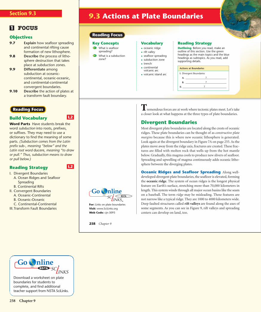
Tremendous forces are at work where tectonic plates meet. Let’s takea closer look at what happens at the three types of plate boundaries.
Divergent BoundariesMost divergent plate boundaries are located along the crests of oceanicridges. These plate boundaries can be thought of as constructive platemargins because this is where new oceanic lithosphere is generated.Look again at the divergent boundary in Figure 7A on page 255. As theplates move away from the ridge axis, fractures are created. These frac-tures are filled with molten rock that wells up from the hot mantlebelow. Gradually, this magma cools to produce new slivers of seafloor.Spreading and upwelling of magma continuously adds oceanic litho-sphere between the diverging plates.
Oceanic Ridges and Seafloor Spreading Along well-developed divergent plate boundaries, the seafloor is elevated, formingthe oceanic ridge. The system of ocean ridges is the longest physicalfeature on Earth’s surface, stretching more than 70,000 kilometers inlength. This system winds through all major ocean basins like the seamon a baseball. The term ridge may be misleading. These features arenot narrow like a typical ridge. They are 1000 to 4000 kilometers wide.Deep faulted structures called rift valleys are found along the axes ofsome segments. As you can see in Figure 9, rift valleys and spreadingcenters can develop on land, too.
Actions at Boundaries
I. Divergent Boundaries
A.
B.
II. ?
?
?
For: Links on plate boundaries
Visit: www.SciLinks.org
Web Code: cjn-3093
258 Chapter 9
FOCUS
Objectives9.7 Explain how seafloor spreading
and continental rifting causeformation of new lithosphere.
9.8 Describe the process of litho-sphere destruction that takesplace at subduction zones.
9.9 Differentiate amongsubduction at oceanic-continental, oceanic-oceanic,and continental-continentalconvergent boundaries.
9.10 Describe the action of plates ata transform fault boundary.
Build VocabularyWord Parts Have students break theword subduction into roots, prefixes,or suffixes. They may need to use adictionary to find the meaning of someparts. (Subduction comes from the Latinprefix sub-, meaning “below” and theLatin root word ducere, meaning “to drawor pull.” Thus, subduction means to drawor pull below.)
Reading StrategyI. Divergent Boundaries
A. Ocean Ridges and SeafloorSpreading
B. Continental RiftsII. Convergent Boundaries
A. Oceanic-ContinentalB. Oceanic-OceanicC. Continental-Continental
III.Transform Fault Boundaries
L2
L2
Reading Focus
1
Section 9.3
Download a worksheet on plateboundaries for students tocomplete, and find additionalteacher support from NSTA SciLinks.
HSES_1eTE_C09.qxd 5/16/04 10:13 AM Page 258

Rift valleys
Red Sea
Gulf of Aden
IndianOcean
LakeVictoria
LakeTanganyika
AFRICA AfarLowlands
Mt. KenyaMt.Kilimanjaro
ArabianPeninsula
NileR
iver
LakeNyasa
Plate Tectonics 259
Upwarping
Continental crust
Riftvalley
Linear sea
Rift
Oceanic ridge
Oceanic crust
Continentalcrust
A
B
C
D
Spreading Center
Seafloor spreading is the process by which plate tectonicsproduces new oceanic lithosphere. Typical rates of spreading aver-age around 5 centimeters per year. These rates are slow on a humantime scale. However, they are rapid enough so that all of Earth’socean basins could have been generated within the last 200 millionyears. In fact, none of the ocean floor that has been dated is olderthan 180 million years.
Figure 9 The East African riftvalleys may represent the initialstages of the breakup of acontinent along a spreadingcenter. A Rising magma forces thecrust upward, causing numerouscracks in the rigid lithosphere. BAs the crust is pulled apart, largeslabs of rock sink, causing a riftzone. C Further spreading causesa narrow sea. D Eventually, anocean basin and ridge system iscreated. Relating Cause and EffectWhat causes the continental crust to stretch and break?
INSTRUCT
Divergent BoundariesBuild Math SkillsConversion Factors Remind studentsto label the units of each factor whensolving the following problem. Doingthis ensures that all the conversionfactors are included and the answer hasthe correct units. Tell students thatseafloor spreading occurs at an averagerate of 5 cm per year. At this rate, howlong would it take for a narrow sea thatis 1 km wide to form? (about 20,000years)Logical
Use VisualsFigure 9 Point out the rising magmain each of the diagrams. Ask: Whathappens to the rising magma in thediagram? (It fills the cracks formed by thediverging plates.) Why is this processcalled seafloor spreading? Does theseafloor actually get thinner andspread out? (The seafloor does not getthinner. Rather, the seafloor spreads apartand new rock is constantly added to theridge.)Visual
Build Science SkillsUsing Models Givestudents two colors ofmodeling clay (onecolor for the magmaand the other color for the crust) andhave them model the activity thatoccurs at a divergent boundary.Kinesthetic, Visual
L2
L1
L1
2
Plate Tectonics 259
Customize for English Language Learners
Encourage students to work in groups tobrainstorm different types of boundaries.Their types of boundaries can come from othersciences, such as cell membranes, or fromeveryday life, such as the boundary between
a sidewalk and the strip of grass between thesidewalk and the curb. Ask students what allthese boundaries have in common and howthey are different.
Answer to . . .
Figure 9 The continental crust isstretched and broken by the upwarpingof the crust, caused by rising magma.
HSES_1eTE_C09.qxd 5/16/04 10:13 AM Page 259

260 Chapter 9
Continental Rifts When spreading centers develop within acontinent, the landmass may split into two or more smaller segments.Examples of active continental rifts include the East African rift valleyand the Rhine Valley in Northwest Europe.
The most widely accepted model for continental breakup suggeststhat forces that are stretching the lithosphere must be acting on the plate.These stretching forces by themselves are not large enough to actuallytear the lithosphere apart. Rather, the rupture of the lithosphere isthought to begin in those areas where plumes of hot rock rise from themantle. This hot-spot activity weakens the lithosphere and creates domesin the crust directly above the hot rising plume. Uplifting stretches thecrust and makes it thinner, as shown in Figure 9A. Along with thestretching, faulting and volcanism form a rift valley, as in Figure 9B
The East African rift valley, shown in Figure 10, may represent thebeginning stage in the breakup of a continent. Large mountains, such asKilimanjaro and Mount Kenya, show the kind of volcanic activity thataccompanies continental rifting. If the stretching forces continue, therift valley will lengthen and deepen, until the continent splits in two. Atthis point, the rift becomes a narrow sea with an outlet to the ocean,similar to the Red Sea. The Red Sea formed when the Arabian Peninsularifted from Africa about 20 million years ago. In this way, the Red Seaprovides scientists with a view of how the Atlantic Ocean may havelooked in its infancy.
How do rifts begin to form?
Figure 10 East African RiftValley This valley may be wherethe African continent is splittingapart.Interpreting Diagrams Whatstage in the drawings on page259 does this photograph show?
260 Chapter 9
Creating aContinental RiftPurpose Students will observe howfractures grow to create a continentalrift as a result of the stretching of thelithosphere.
Materials 2 slices of individuallywrapped American cheese, dull knifeor fingernail, metric ruler
Procedure Using your fingernail or adull knife, make a small cut in the centerof a cheese slice parallel to one edge.Pull on the two cheese edges parallelto the cut. You will be pullingperpendicular to the direction of thecut. Observe how the small defect (thecut) concentrates the tearing. Observethe shape of the fracture that forms,especially the pointed tips where thetearing is taking place, and how thefracture tips move faster as the fracturegets bigger.
Now, make a cut near the center of thesecond piece of cheese. Make a secondparallel cut about 2 cm below and 2 cmto the right of the first cut. Pull on thecheese as before. Fractures will begin toform from each of the cuts. As the tipsof these fractures begin to move pasteach other, they will begin to curvetoward each other and eventually linkup into a single fracture.
Safety Do not allow students to eat thecheese.
Expected Outcome Students shouldinfer that the fractures in the cheese areanalogous to the formation of faults thatresult in the development of a rift valley.Visual, Logical
L2
Section 9.3 (continued)
The first rift that developed as Pangaea beganto break apart 200 million years ago resultedin the separation of North America and Africa.Large quantities of basalts were produced.These basalts can be found today asweathered rock beds along the eastern
seaboard of the United States. They are buriedbeneath rocks that form the continental shelfand have been radiometrically dated as beingbetween 200 million and 165 million yearsold. The rifting eventually formed the AtlanticOcean basin.
Facts and Figures
HSES_1eTE_C09.qxd 5/16/04 10:14 AM Page 260
Subducting oceanic lithosphere
Oceanic crust
Trench
Continentalvolcanic arc
Continental crust
Asthenosphere
Continentallithosphere
Melting
100 km
200 km
Plate Tectonics 261
Figure 11 Oceanic-ContinentalConvergent Boundary Oceaniclithosphere is subducted beneatha continental plate. Inferring Why doesn’t volcanicactivity occur closer to the trench?
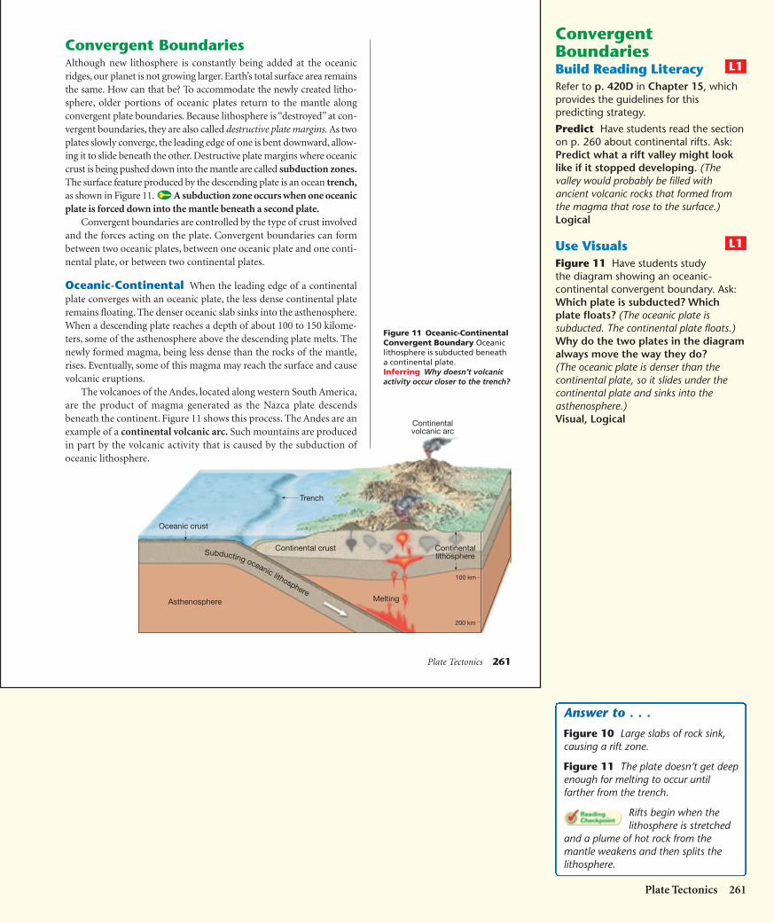
Convergent BoundariesAlthough new lithosphere is constantly being added at the oceanicridges, our planet is not growing larger. Earth’s total surface area remainsthe same. How can that be? To accommodate the newly created litho-sphere, older portions of oceanic plates return to the mantle alongconvergent plate boundaries. Because lithosphere is “destroyed” at con-vergent boundaries, they are also called destructive plate margins. As twoplates slowly converge, the leading edge of one is bent downward, allow-ing it to slide beneath the other. Destructive plate margins where oceaniccrust is being pushed down into the mantle are called subduction zones.The surface feature produced by the descending plate is an ocean trench,as shown in Figure 11. A subduction zone occurs when one oceanicplate is forced down into the mantle beneath a second plate.
Convergent boundaries are controlled by the type of crust involvedand the forces acting on the plate. Convergent boundaries can formbetween two oceanic plates, between one oceanic plate and one conti-nental plate, or between two continental plates.
Oceanic-Continental When the leading edge of a continentalplate converges with an oceanic plate, the less dense continental plateremains floating. The denser oceanic slab sinks into the asthenosphere.When a descending plate reaches a depth of about 100 to 150 kilome-ters, some of the asthenosphere above the descending plate melts. Thenewly formed magma, being less dense than the rocks of the mantle,rises. Eventually, some of this magma may reach the surface and causevolcanic eruptions.
The volcanoes of the Andes, located along western South America,are the product of magma generated as the Nazca plate descendsbeneath the continent. Figure 11 shows this process. The Andes are anexample of a continental volcanic arc. Such mountains are producedin part by the volcanic activity that is caused by the subduction ofoceanic lithosphere.
ConvergentBoundariesBuild Reading LiteracyRefer to p. 420D in Chapter 15, whichprovides the guidelines for thispredicting strategy.
Predict Have students read the sectionon p. 260 about continental rifts. Ask:Predict what a rift valley might looklike if it stopped developing. (Thevalley would probably be filled withancient volcanic rocks that formed fromthe magma that rose to the surface.)Logical
Use VisualsFigure 11 Have students studythe diagram showing an oceanic-continental convergent boundary. Ask:Which plate is subducted? Whichplate floats? (The oceanic plate issubducted. The continental plate floats.)Why do the two plates in the diagramalways move the way they do?(The oceanic plate is denser than thecontinental plate, so it slides under thecontinental plate and sinks into theasthenosphere.)Visual, Logical
L1
L1
Plate Tectonics 261
Answer to . . .
Figure 10 Large slabs of rock sink,causing a rift zone.
Figure 11 The plate doesn’t get deepenough for melting to occur untilfarther from the trench.
Rifts begin when thelithosphere is stretched
and a plume of hot rock from themantle weakens and then splits thelithosphere.
HSES_1eTE_C09.qxd 5/16/04 10:14 AM Page 261
262 Chapter 9
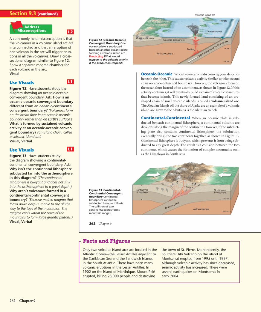
Oceanic-Oceanic When two oceanic slabs converge, one descendsbeneath the other. This causes volcanic activity similar to what occursat an oceanic-continental boundary. However, the volcanoes form onthe ocean floor instead of on a continent, as shown in Figure 12. If thisactivity continues, it will eventually build a chain of volcanic structuresthat become islands. This newly formed land consisting of an arc-shaped chain of small volcanic islands is called a volcanic island arc.The Aleutian Islands off the shore of Alaska are an example of a volcanicisland arc. Next to the Aleutians is the Aleutian trench.
Continental-Continental When an oceanic plate is sub-ducted beneath continental lithosphere, a continental volcanic arcdevelops along the margin of the continent. However, if the subduct-ing plate also contains continental lithosphere, the subductioneventually brings the two continents together, as shown in Figure 13.Continental lithosphere is buoyant, which prevents it from being sub-ducted to any great depth. The result is a collision between the twocontinents, which causes the formation of complex mountains suchas the Himalayas in South Asia.
Subducting oceanic lithosphere
Oceanic crust
Trench
Continental crust
Melting
Asthenosphere
Oceanic lithosphere
Volcanic island arc
100 km
200 km
Continentallithosphere
Oceanic plate
Continentallithosphere
Asthenosphere
100 km
200 km
SutureFigure 13 Continental-Continental ConvergentBoundary Continentallithosphere cannot besubducted because it floats.The collision of twocontinental plates formsmountain ranges.
Figure 12 Oceanic-OceanicConvergent Boundary Oneoceanic plate is subductedbeneath another oceanic plate,forming a volcanic island arc. Predicting What wouldhappen to the volcanic activityif the subduction stopped?
262 Chapter 9
A commonly held misconception is thatthe volcanoes in a volcanic island arc areinterconnected and that an eruption ofone volcano in the arc will trigger erup-tions in all the volcanoes. Draw a cross-sectional diagram similar to Figure 12.Show a separate magma chamber foreach volcano in the arc.Visual
Use VisualsFigure 12 Have students study thediagram showing an oceanic-oceanicconvergent boundary. Ask: How is anoceanic-oceanic convergent boundarydifferent from an oceanic-continentalconvergent boundary? (Volcanoes formon the ocean floor in an oceanic-oceanicboundary rather than on Earth’s surface.)What is formed by sustained volcanicactivity at an oceanic-oceanic conver-gent boundary? (an island chain, calleda volcanic island arc)Visual, Verbal
Use VisualsFigure 13 Have students studythe diagram showing a continental-continental convergent boundary. Ask:Why isn’t the continental lithospheresubducted far into the asthenospherein this diagram? (The continentallithosphere is buoyant and does not sinkinto the asthenosphere to a great depth.)Why aren’t volcanoes formed in acontinental-continental convergentboundary? (Because molten magma thatforms down deep is unable to rise all theway to the tops of the mountains. Themagma cools within the cores of themountains to form large granitic plutons.)Visual, Verbal
L1
L1
L2
Section 9.3 (continued)
Only two volcanic island arcs are located in theAtlantic Ocean—the Lesser Antilles adjacent tothe Caribbean Sea and the Sandwich Islandsin the South Atlantic. There have been manyvolcanic eruptions in the Lesser Antilles. In1902 on the island of Martinique, Mount Peléerupted, killing 28,000 people and destroying
the town of St. Pierre. More recently, theSoufriere Hills Volcano on the island ofMontserrat erupted from 1995 until 1997.Although volcanic activity has since decreased,seismic activity has increased. There wereseveral earthquakes on Montserrat inearly 2004.
Facts and Figures
HSES_1eTE_C09.qxd 5/16/04 10:15 AM Page 262
Subducting oceanic lithosphere
India
Continentalshelf
deposits
Continentalcrust
Ocean basin
Continental volcanic arc
Tibet
MeltingAsthenosphere
Developingaccretionary
wedge
Plate Tectonics 263
Indiatoday
10 millionyears ago
38 millionyears ago
55 millionyears ago
71 millionyears ago
Himalayas
India(Ganges Plain)
TibetanPlateau
Suture
Asthenosphere
Figure 14 A The leading edge ofthe plate carrying India issubducted beneath the Eurasianplate. B The landmasses collideand push up the crust. C India’scollision with Asia continuestoday.
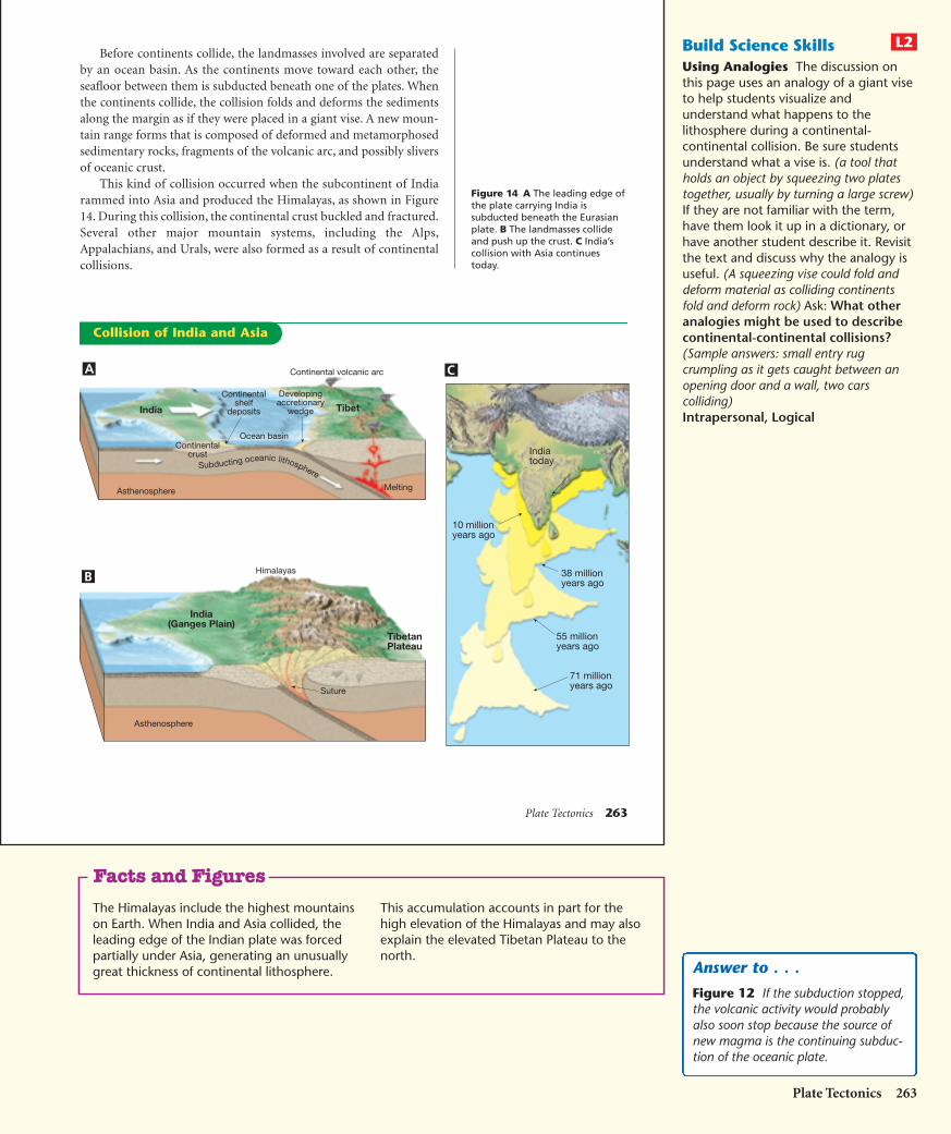
Before continents collide, the landmasses involved are separatedby an ocean basin. As the continents move toward each other, theseafloor between them is subducted beneath one of the plates. Whenthe continents collide, the collision folds and deforms the sedimentsalong the margin as if they were placed in a giant vise. A new moun-tain range forms that is composed of deformed and metamorphosedsedimentary rocks, fragments of the volcanic arc, and possibly sliversof oceanic crust.
This kind of collision occurred when the subcontinent of Indiarammed into Asia and produced the Himalayas, as shown in Figure14. During this collision, the continental crust buckled and fractured.Several other major mountain systems, including the Alps,Appalachians, and Urals, were also formed as a result of continentalcollisions.
A
B
C
Collision of India and Asia
Build Science SkillsUsing Analogies The discussion onthis page uses an analogy of a giant viseto help students visualize andunderstand what happens to thelithosphere during a continental-continental collision. Be sure studentsunderstand what a vise is. (a tool thatholds an object by squeezing two platestogether, usually by turning a large screw)If they are not familiar with the term,have them look it up in a dictionary, orhave another student describe it. Revisitthe text and discuss why the analogy isuseful. (A squeezing vise could fold anddeform material as colliding continentsfold and deform rock) Ask: What otheranalogies might be used to describecontinental-continental collisions?(Sample answers: small entry rugcrumpling as it gets caught between anopening door and a wall, two carscolliding)Intrapersonal, Logical
L2
Plate Tectonics 263
The Himalayas include the highest mountainson Earth. When India and Asia collided, theleading edge of the Indian plate was forcedpartially under Asia, generating an unusuallygreat thickness of continental lithosphere.
This accumulation accounts in part for thehigh elevation of the Himalayas and may alsoexplain the elevated Tibetan Plateau to thenorth.
Facts and Figures
Answer to . . .
Figure 12 If the subduction stopped,the volcanic activity would probablyalso soon stop because the source ofnew magma is the continuing subduc-tion of the oceanic plate.
HSES_1eTE_C09.qxd 5/16/04 10:15 AM Page 263

264 Chapter 9
Section 9.3 Assessment
Reviewing Concepts1. What is seafloor spreading?
2. What is a subduction zone? What types ofplate boundaries have subduction zones?
3. Describe the process that occurs whencontinents converge.
4. What actions of plate boundaries cause thedestruction of the lithosphere?
Critical Thinking5. Drawing Conclusions What evidence
supports the idea that the Earth is neithergrowing nor shrinking in size?
6. Relating Cause and Effect During thecollision between two continents, why doesn’ta subduction zone form?
7. Predicting How will the angle at which anoceanic plate is subducted affect the distancefrom the volcanic arc to the trench?
Transform fault(active)
Fracturezone
Fracturezone
Creative Writing Write a paragraph thatdescribes the rifting apart of a continent toform a new ocean. The paragraph shouldbe written from the point of view of a per-son witnessing the events.
Figure 15 A transform faultboundary offsets segments ofa divergent boundary at anoceanic ridge.
Transform FaultBoundariesThe third type of plate boundary is thetransform fault boundary. At atransform fault boundary, platesgrind past each other without destroy-ing the lithosphere. Most transformfaults join two segments of a mid-oceanridge, as shown in Figure 15. Thesefaults are present about every 100 kilo-meters along the ridge axis. Activetransform faults lie between the two
offset ridge segments. The seafloor produced at one ridge axis moves inthe opposite direction as seafloor is produced at an opposing ridge seg-ment. So between the ridge segments these slabs of oceanic crust aregrinding past each other along a transform fault.
Although most transform faults are located within the ocean basins,a few cut through the continental crust. One example is the San AndreasFault of California. Along the San Andreas, the Pacific plate is movingtoward the northwest, past the North American plate. If this movementcontinues, that part of California west of the fault zone will become anisland off the west coast of the United States and Canada. It could even-tually reach Alaska. However, a more immediate concern is theearthquake activity triggered by movements along this fault system.
264 Chapter 9
Transform FaultBoundariesBuild Science SkillsRelating Cause and Effect Remindstudents that plates in a transform faultboundary move past each other withoutproduction or destruction of lithosphere.Ask: Why does this movement causeearthquakes? (The tremendous frictioncaused by two plates grinding past eachother causes earthquakes.)Logical
ASSESSEvaluateUnderstandingTo assess students’ knowledge of sectioncontent, have them write three shortparagraphs describing the threeconvergent boundaries and whatresults when they converge.
ReteachHave students demonstrate the actionof the three convergent boundaries byusing their hands to represent theconverging plates.
Answers should be accurate and showan understanding of the process ofrifting at a divergent plate boundary.
L1
L2
3
L2
Section 9.3 (continued)
5. the evidence that the production anddestruction of the lithosphere is going on atabout the same rate.6. Continental lithosphere floats and can’t beforced down into the mantle at a subductionzone.7. The higher the angle of subduction, thecloser the volcanic arc will be to the trench.If the angle is shallow, the volcanic arc will belocated farther behind the trench because thedescending plate doesn’t reach a depthwhere melting occurs until farther fromthe trench.
Section 9.3 Assessment
1. Seafloor spreading is the creation of newseafloor at oceanic ridges.2. Subduction zones occur at deep-oceantrenches where slabs of oceanic lithosphereare descending into the mantle. Subductionzones are associated with convergent bound-aries, either oceanic-oceanic or oceanic-continental.3. two continental plates collide with eachother, forming a mountain range4. Lithosphere is destroyed at convergentboundaries in subduction zones.
HSES_1eTE_C09.qxd 9/27/04 3:27 AM Page 264
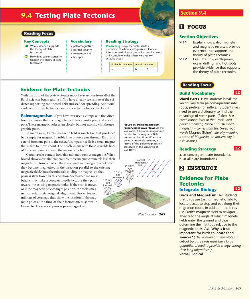
Plate Tectonics 265
9.4 Testing Plate Tectonics
Reading StrategyPredicting Copy the table. Write aprediction of where earthquakes will occur.After you read, if your prediction was incorrector incomplete, write where earthquakesactually occur.
Key ConceptsWhat evidence supportsthe theory of platetectonics?
How does paleomagnetismsupport the theory of platetectonics?
Vocabulary◆ paleomagnetism◆ normal polarity◆ reverse polarity◆ hot spot
Probable Locations Actual Locations
a. b. ??
Evidence for Plate TectonicsWith the birth of the plate tectonics model, researchers from all of theEarth sciences began testing it. You have already seen some of the evi-dence supporting continental drift and seafloor spreading. Additionalevidence for plate tectonics came as new technologies developed.
Paleomagnetism If you have ever used a compass to find direc-tion, you know that the magnetic field has a north pole and a southpole. These magnetic poles align closely, but not exactly, with the geo-graphic poles.
In many ways, Earth’s magnetic field is much like that producedby a simple bar magnet. Invisible lines of force pass through Earth andextend from one pole to the other. A compass needle is a small magnetthat is free to move about. The needle aligns with these invisible linesof force and points toward the magnetic poles.
Certain rocks contain iron-rich minerals, such as magnetite. Whenheated above a certain temperature, these magnetic minerals lose theirmagnetism. However, when these iron-rich mineral grains cool down,they become magnetized in the direction parallel to the existingmagnetic field. Once the minerals solidify, the magnetism theypossess stays frozen in this position. So magnetized rocksbehave much like a compass needle because they pointtoward the existing magnetic poles. If the rock is movedor if the magnetic pole changes position, the rock’s mag-netism retains its original alignment. Rocks formedmillions of years ago thus show the location of the mag-netic poles at the time of their formation, as shown inFigure 16. These rocks possess paleomagnetism.
Normalmagnetic
field0.4 m.y.ago
(normal)0.8 m.y.ago
(reversed)1.2 m.y.
ago(normal)
Figure 16 PaleomagnetismPreserved in Lava Flows As thelava cools, it becomes magnetizedparallel to the magnetic fieldpresent at that time. When thepolarity randomly reverses, arecord of the paleomagnetism ispreserved in the sequence of lava flows.
FOCUS
Section Objectives9.11 Explain how paleomagnetism
and magnetic reversals provideevidence that supports thetheory of plate tectonics.
9.12 Evaluate how earthquakes,ocean drilling, and hot spotsprovide evidence that supportsthe theory of plate tectonics.
Build VocabularyWord Parts Have students break thevocabulary term paleomagnetism intoroots, prefixes, or suffixes. Students mayneed to use a dictionary to find themeanings of some parts. (Paleo- is acombination form of the Greek wordpalaios meaning “ancient.” The wordmagnetism comes from the Greek rootwords Magnes (lithos), literally meaninga stone of Magnesia, an ancient city inAsia Minor.)
Reading Strategya. at convergent plate boundariesb. at all plate boundaries
INSTRUCT
Evidence for PlateTectonicsIntegrate BiologyBirds and Magnetism Tell studentsthat birds use Earth’s magnetic field tolocate places to stop and eat along theirmigration route. In addition, the birdsuse Earth’s magnetic field to navigate.They read the angle at which magneticfields enter the ground and thusdetermine their latitude relative to themagnetic poles. Ask: Why is it soimportant for birds to locate foodsources? (The location of these places iscritical because birds must have largequantities of food to provide energy duringtheir long migrations.)Verbal, Logical
L2
2
L2
L2
Reading Focus
1
Plate Tectonics 265
Section 9.4
HSES_1eTE_C09.qxd 5/16/04 10:16 AM Page 265

266 Chapter 9
Geophysicists learned thatEarth’s magnetic field periodicallyreverses polarity. The north mag-netic pole becomes the southmagnetic pole, and vice versa. A rocksolidifying during one of the periodsof reverse polarity will be magnet-ized with the polarity opposite thatof rocks being formed today.
When rocks show the samemagnetism as the present magneticfield, they are described as havingnormal polarity. Rocks that showthe opposite magnetism are said tohave reverse polarity. A relation-ship was discovered between themagnetic reversals and the seafloor-spreading hypothesis. Ships towedinstruments called magnetometersacross segments of the ocean floor.This research revealed alternatingstrips of high- and low-intensity
magnetism that ran parallel to the ridges. The strips of high-inten-sity magnetism are regions where the paleomagnetism of the oceancrust is of the normal type. These positively magnetized rocksenhance the existing magnetic field. The low-intensity strips repre-sent regions where the ocean crust is polarized in the reverse directionand, therefore, weaken the existing magnetic field. As new basalt isadded to the ocean floor at the oceanic ridges, it becomes magnetizedaccording to the existing magnetic field, as shown in Figure 17.
The discovery of strips of alternating polarity, which lie asmirror images across the ocean ridges, is among the strongest evi-dence of seafloor spreading.
Earthquake Patterns Scientists found a close linkbetween deep-focus earthquakes and ocean trenches. Also, theabsence of deep-focus earthquakes along the oceanic ridge systemwas shown to be consistent with the new theory.
Compare the distribution of earthquakes shown in Chapter 8 onpage 226 with the map of plate boundaries on pages 256–257. Theclose link between plate boundaries and earthquakes is obvious. Whenthe depths of earthquake foci and their locations within the trench sys-tems are plotted, a pattern emerges.
Figure 17 A As new material isadded to the ocean floor at theoceanic ridges, it is magnetizedaccording to Earth’s existingmagnetic field. B This processrecords each reversal of Earth’smagnetic field. C Because newrock is added in approximatelyequal amounts to the trailingedges of both plates, strips ofequal size and polarity parallelboth sides of the ocean ridges. Applying Concepts Why arethe magnetized strips aboutequal width on either side of the ridge?
Period of normal magnetism
Period of reverse magnetism
Period of normal magnetism
Magma
Magma
Magma
A
B
C
Polarity of Ocean Crust
266 Chapter 9
Testing Mineralsfor MagnetismPurpose Students test various mineralswith a magnet to determine whetherthey have magnetic properties.
Materials magnet, minerals (includeat least one sample of a mineral thatcontains iron or cobalt), compass
Procedure Have students test themineral samples with the magnet to seeif they are attracted by it. Have studentsplace the compass near each mineralsample to see if the needle moves.If it does, the material is magnetic.
Expected Outcomes Minerals thatcontain iron or cobalt, such aslodestone, have magnetic properties.Meteorites also have magneticproperties.Kinesthetic, Visual
Use VisualsFigure 17 Have students study thefigure. Ask: Could the rocks in a strippossessing reverse polarity ever possessnormal polarity? (No, once the rockssolidify, their polarity is permanently set.)How do you think the width of a striprelates to the seafloor spreading rate?(The faster the spreading rate is, the widerthe strip will be.)Visual, Logical
L1
L1
Section 9.4 (continued)
Customize for English Language Learners
Explain to students that there are many uses ofthe term polar, both in science and in everydayusage. For example, in magnetism, polarityrefers to the magnetic poles. In chemistry,
polar molecules have partial charges. Polar alsomeans diametrically opposite. Have studentslook up the various meanings of the term polarand use each meaning in a sentence.
HSES_1eTE_C09.qxd 5/16/04 10:16 AM Page 266
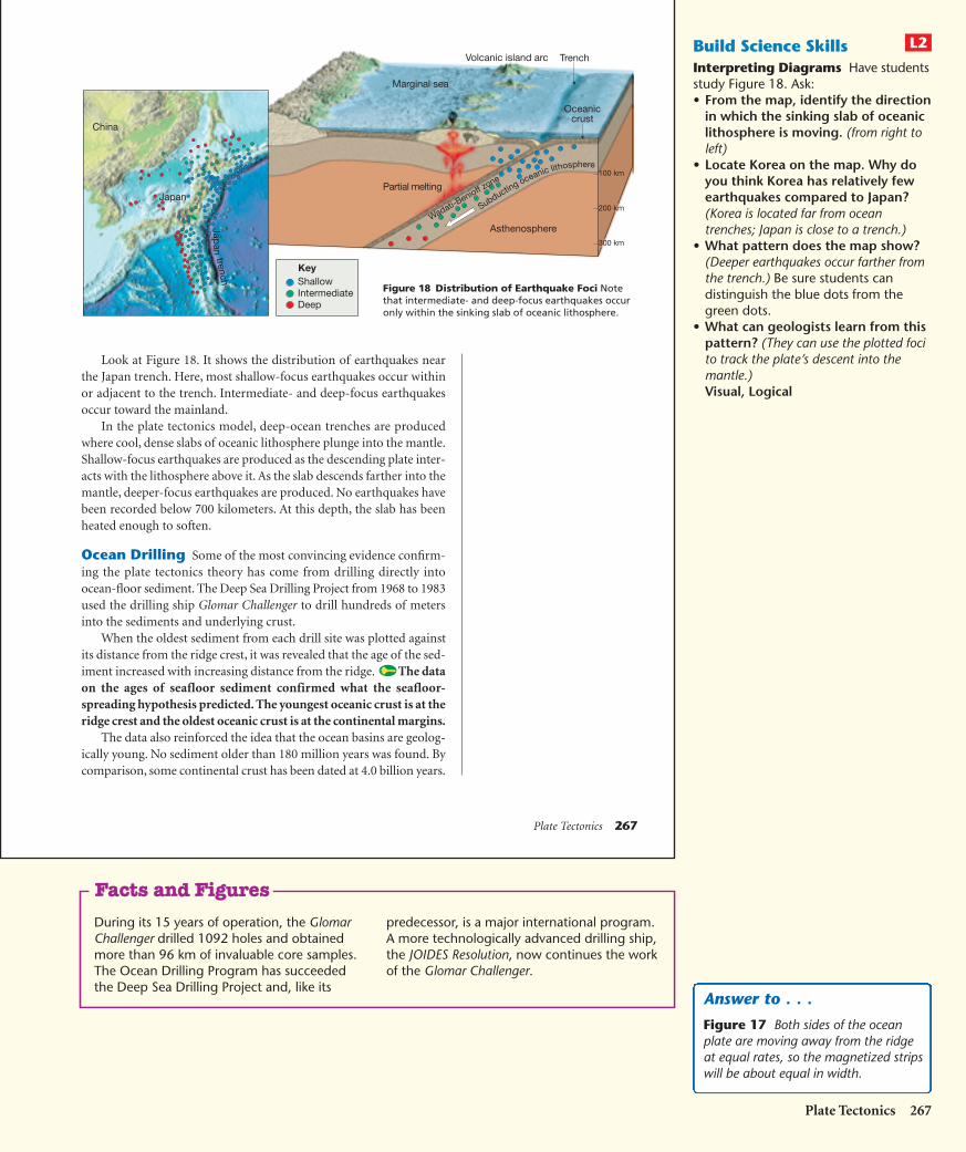
Plate Tectonics 267
Look at Figure 18. It shows the distribution of earthquakes nearthe Japan trench. Here, most shallow-focus earthquakes occur withinor adjacent to the trench. Intermediate- and deep-focus earthquakesoccur toward the mainland.
In the plate tectonics model, deep-ocean trenches are producedwhere cool, dense slabs of oceanic lithosphere plunge into the mantle.Shallow-focus earthquakes are produced as the descending plate inter-acts with the lithosphere above it. As the slab descends farther into themantle, deeper-focus earthquakes are produced. No earthquakes havebeen recorded below 700 kilometers. At this depth, the slab has beenheated enough to soften.
Ocean Drilling Some of the most convincing evidence confirm-ing the plate tectonics theory has come from drilling directly intoocean-floor sediment. The Deep Sea Drilling Project from 1968 to 1983used the drilling ship Glomar Challenger to drill hundreds of metersinto the sediments and underlying crust.
When the oldest sediment from each drill site was plotted againstits distance from the ridge crest, it was revealed that the age of the sed-iment increased with increasing distance from the ridge. The dataon the ages of seafloor sediment confirmed what the seafloor-spreading hypothesis predicted. The youngest oceanic crust is at theridge crest and the oldest oceanic crust is at the continental margins.
The data also reinforced the idea that the ocean basins are geolog-ically young. No sediment older than 180 million years was found. Bycomparison, some continental crust has been dated at 4.0 billion years.
Marginal sea
Volcanic island arc Trench
Oceaniccrust
Partial melting
Wadati-Benioff z
one
Asthenosphere
100 km
200 km
300 km
Subducting oceanic lithosphere
China
Japan
Japan
trench
KeyShallowIntermediateDeep
Figure 18 Distribution of Earthquake Foci Notethat intermediate- and deep-focus earthquakes occuronly within the sinking slab of oceanic lithosphere.
Build Science SkillsInterpreting Diagrams Have studentsstudy Figure 18. Ask:• From the map, identify the direction
in which the sinking slab of oceaniclithosphere is moving. (from right toleft)
• Locate Korea on the map. Why doyou think Korea has relatively fewearthquakes compared to Japan?(Korea is located far from oceantrenches; Japan is close to a trench.)
• What pattern does the map show?(Deeper earthquakes occur farther fromthe trench.) Be sure students candistinguish the blue dots from thegreen dots.
• What can geologists learn from thispattern? (They can use the plotted focito track the plate’s descent into themantle.)Visual, Logical
L2
Plate Tectonics 267
During its 15 years of operation, the GlomarChallenger drilled 1092 holes and obtainedmore than 96 km of invaluable core samples.The Ocean Drilling Program has succeededthe Deep Sea Drilling Project and, like its
predecessor, is a major international program.A more technologically advanced drilling ship,the JOIDES Resolution, now continues the workof the Glomar Challenger.
Facts and Figures
Answer to . . .
Figure 17 Both sides of the oceanplate are moving away from the ridgeat equal rates, so the magnetized stripswill be about equal in width.
HSES_1eTE_C09.qxd 5/16/04 10:17 AM Page 267

268 Chapter 9
Section 9.4 Assessment
Reviewing Concepts1. List and describe the evidence for the
plate tectonics theory.
2. Define the term paleomagnetism.
3. What is the age of the oldest ocean crust?How do the ages of the ocean crust compareto the age of continental rocks?
4. What is a hot spot?
Critical Thinking5. Applying Concepts How do hot spots and
the plate tectonics theory account for thedifferent ages of the Hawaiian Islands?
6. Predicting Would earthquakes occur atdepths of over 700 kilometers? Why orwhy not?
Hot Spots Mapping of seafloor volcanoes in the Pacific revealed achain of volcanic structures extending from the Hawaiian Islands toMidway Island and then north to the Aleutian trench, as shown inFigure 19. Dates of volcanoes in this chain showed that the volcanoesincrease in age with increasing distance from Hawaii. Suiko Seamountis 65 million years old. Midway Island is 27 million years old. Theisland of Hawaii formed less than a million years ago and is stillforming today.
A rising plume of mantle material is located below the island ofHawaii. Melting of this hot rock as it nears the surface creates a vol-canic area, or hot spot. As the Pacific plate moves over the hot spot,successive volcanic mountains have been created. The age of each vol-cano indicates the time when it was situated over the hot spot. Kauaiis the oldest of the large islands in the Hawaiian chain. Its volcanoes areextinct. The youthful island of Hawaii has two active volcanoes—Mauna Loa and Kilauea. Hot spot evidence supports the idea thatthe plates move over Earth’s surface.
Figure 19 Hot Spot The chain ofislands and seamounts thatextends from Hawaii to theAleutian trench results from themovement of the Pacific plateover a stationary hot spot.Predicting Where will a newHawaiian island be located?
Explanatory Paragraph Write a para-graph explaining why the age pattern ofthe ocean floor supports seafloor spreading.
Direction ofplate motion
Kauai3.8–5.6 Oahu
2.2–3.3 Molokai1.3–1.8
Mauiless
than 1.0
Hawaii0.7 to
present
Hotspot
Oceaniclithosphere
Mantleplume
Ages givenin millions of
years
EmperorSeamount chain
Suiko65 my
Hawaiian chain
Hawaii
MidwayIslands27 my
268 Chapter 9
Build Reading LiteracyRefer to p. 530D in Chapter 19, whichprovides the guidelines for makinginferences.
Making Inferences Have studentsread the section about hot spots on thispage. Ask: What can you infer about ahot spot from the description of howthe islands in a volcanic island arcform at different times by the hotspot? (You can infer that the hot spot isrelatively stationary with respect to themantle, and so moves relative to the plate.If it moved along with the plate, a line ofislands would not have formed.)Verbal, Intrapersonal
ASSESSEvaluateUnderstandingTo assess students’ knowledge of sectioncontent, have them make flashcards forthe vocabulary terms and the four linesof evidence supporting the platetectonic theory. For each vocabularyterm, the card should include adefinition and an example, whereapplicable. For each line of evidence, thecard should give an explanation of whyit supports the theory and include anexample. Students can use the cards toquiz one another.
ReteachHave students explain in their ownwords why data produced by drillinginto ocean-floor sediment supports thetectonic plate theory.
The age of the seafloor increases withincreasing distance from the spreadingcenter at an ocean ridge. The theory ofseafloor spreading states that new oceanlithosphere is created at ocean ridges,so the ocean floor should be youngercloser to the ridges and older fartherfrom the ridge.
L1
L2
3
L1
Section 9.4 (continued)
3. The oldest ocean crust is about 180 millionyears old. Some continental rocks are about3.9 billion years old.4. an area where a plume of hot mantlematerial rises up and causes volcanic activity5. Hot spots are relatively stationary plumes ofhot rock from the mantle. As a plate movesover a hot spot, the hot material causes vol-canic activity. The previously formed volca-noes become extinct and increase in age asthe distance from the hot spot (and the activevolcanic activity) increases.6. No, below 700 km the plates are no longerrigid enough.
Section 9.4 Assessment
1. paleomagnetism: iron-rich minerals in rocksline up with the magnetic field at the timethey cool; earthquake patterns: earthquakefoci are concentrated at plate boundaries;ocean drilling: the age of the ocean litho-sphere was found from drilling; hot spots:the location of hot mantle plumes showsplate motion.2. Paleomagnetism is the natural magnetismin rocks, which was acquired from Earth’smagnetic field at the time the rock formed.
Answer to . . .
Figure 19 A new Hawaiian islandwill form to the southeast of the islandof Hawaii.
268_PH_ES_TE_2p 9/23/04 7:14 PM Page 268

Plate Tectonics 269
9.5 Mechanisms of Plate Motion
Reading StrategyIdentifying Main Ideas Copy the table. Asyou read, write the main ideas for each topic.
Key ConceptsWhat are the mechanismsof plate motion?
What causes platemotion?
Vocabulary◆ convective flow◆ slab-pull◆ ridge-push◆ mantle plume
Causes of Plate MotionScientists generally agree that convection occurring in the
mantle is the basic driving force for plate movement. During con-vection, warm, less dense material rises and cooler, denser materialsinks. The motion of matter resulting from convection is called con-vective flow. The slow movements of the plates and mantle are drivenby the unequal distribution of Earth’s heat. The heat is generated by theradioactive decay of elements, such as uranium, found within Earth’smantle and crust.
Slab-Pull and Ridge-Push Several mechanisms produce forcesthat cause plate motion. One mechanism, called slab-pull, occursbecause old oceanic crust, which is relatively cool and dense, sinks intothe asthenosphere and “pulls” the trailing lithosphere along. Slab-pull is thought to be the primary downward arm of convective flowin the mantle. By contrast, ridge-push results from the elevated posi-tion of the oceanic ridge system. Ridge-push causes oceaniclithosphere to slide down the sides of the oceanic ridge. The down-ward slide is the result of gravity acting on the oceanic lithosphere.Ridge-push, although active in some spreading centers, is probably lessimportant than slab-pull.
Mantle Convection Most models suggest that hot plumes ofrock are the upward flowing arms in mantle convection. These risingmantle plumes sometimes show themselves on Earth’s surface as hotspots and volcanoes.
Topic Main Idea
Slab-pull a.
Ridge-push b.
Mantle convection c. ?
?
?
FOCUS
Section Objectives9.13 Compare the mechanisms of
slab-pull and ridge-push ascontributing to plate motion.
9.14 Relate the unequal distributionof heat in Earth and the mecha-nism of mantle convection tothe movement of tectonicplates.
Build VocabularyParaphrase Have students explain, intheir own words, the meaning of thenew vocabulary terms in this section.Since each term contains an “action-type” word (pull, push, plume, convec-tion), students should be able to formmental images to help with theirexplanations.
Reading Strategya. mechanism of plate motion in whichthe descending slab pulls on the plateb. mechanism of plate motion in whichthe force of new crust formed at thehigh ridges pushes on the platec. the major mechanism of plate motionas the upward flow of hot, less densemantle material and the downward flowof cold, dense material drives platetectonics
INSTRUCT
Causes of PlateMotionBuild Science SkillsUsing Models Challenge students touse their hands, phone books, or otherobjects to model slab-pull and ridge-push. Have them explain the processesas they manipulate the model.Verbal, Kinesthetic
L2
2
L2
L2
Reading Focus
1
Plate Tectonics 269
Section 9.5
HSES_1eTE_C09.qxd 5/16/04 10:17 AM Page 269
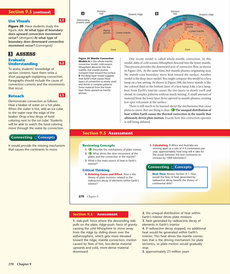
270 Chapter 9
Section 9.5 Assessment
Reviewing Concepts1. Describe the mechanisms of plate motion.
2. What drives the slow movement of theplates and the convection in the mantle?
3. What is the main source of heat in Earth’sinterior?
Critical Thinking4. Relating Cause and Effect How is the
theory of plate tectonics related to theradioactive decay of elements within Earth’sinterior?
5. Calculating If Africa and Australia aremoving apart at a rate of 4.4 centimeters peryear, approximately how long will it take forthe ocean between the two continents toincrease by 1000 kilometers?
One recent model is called whole-mantle convection. In thismodel, slabs of cold oceanic lithosphere descend into the lower mantle.This process provides the downward arm of convective flow, as shownin Figure 20A. At the same time, hot mantle plumes originating nearthe mantle-core boundary move heat toward the surface. Anothermodel is the deep-layer model. You might compare this model to a lavalamp on a low setting. As shown in Figure 20B, the lower mantle is likethe colored fluid in the bottom layer of a lava lamp. Like a lava lamp,heat from Earth’s interior causes the two layers to slowly swell andshrink in complex patterns without much mixing. A small amount ofmaterial from the lower layer flows upward as mantle plumes, creatinghot-spot volcanism at the surface.
There is still much to be learned about the mechanisms that causeplates to move. But one thing is clear. The unequal distribution ofheat within Earth causes the thermal convection in the mantle thatultimately drives plate motion. Exactly how this convection operatesis still being debated.
Figure 20 Mantle ConvectionModels A In the whole-mantleconvection model, cold oceaniclithosphere descends into themantle. Hot mantle plumestransport heat toward the surface.B The deep-layer model suggeststhat Earth’s heat causes theselayers of convection to slowly swelland shrink in complex patterns.Some material from the lowerlayer flows upward as mantleplumes.
Descendingoceanic plate
Volcanictrail
Hotspot
Risingplume
Oceanic ridge
Core
Lower mantle
Upper mantle
Volcanictrail
Hotspot
Mantleplume
Oceanic ridge
Core
Upper mantle
660
km
Lower mantle
Heat Flow Review Section 9.1. Howwould the flow of heat generated byradioactive decay benefit the theory ofcontinental drift?
A B
270 Chapter 9
Use VisualsFigure 20 Have students study thefigure. Ask: At what type of boundarydoes upward convective movementoccur? (divergent) At what type ofboundary does downward convectivemovement occur? (convergent)
ASSESSEvaluateUnderstandingTo assess students’ knowledge ofsection content, have them write ashort paragraph explaining convection.Paragraphs should include the cause ofconvection currents and the movementsthat occur.
ReteachDemonstrate convection as follows:Heat a beaker of water on a hot plate.When the water is hot, add an ice cubeto the water near the edge of thebeaker. Drop a few drops of foodcoloring next to the ice cube. Studentswill be able to watch the food coloringmove through the water by convection.
It would provide the missing mechanismthat causes the continents to move.
L1
L2
3
L1
Section 9.5 (continued)
2. the unequal distribution of heat withinEarth’s interior drives plate motions3. heat generated by radioactive decay ofelements in Earth’s interior4. If radioactive decay stopped, no additionalheat would be generated within Earth’sinterior. This heat drives the mantle convec-tion that is the driving mechanism for platetectonics, so plate motion would graduallystop.5. approximately 23 million years
Section 9.5 Assessment
1. slab-pull: force where the descending slabpulls on the plate; ridge-push: force of gravitycausing the cold lithosphere to move awayfrom the ridge by sliding down over theasthenosphere, which gets more elevatedtoward the ridge; mantle convection: motioncaused by flow of hot, less-dense materialupwards and cold, more-dense materialdownward
HSES_1eTE_C09.qxd 5/16/04 10:18 AM Page 270
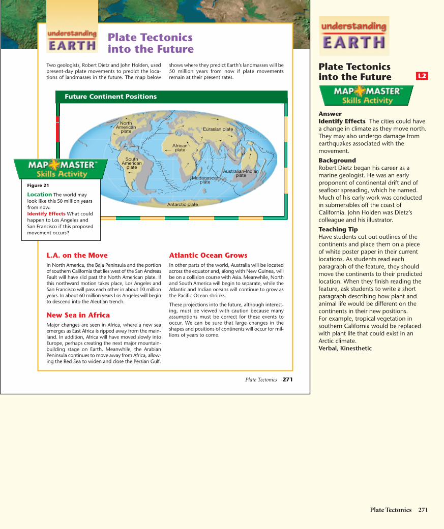
Plate Tectonics 271
Plate Tectonicsinto the Future
L.A. on the MoveIn North America, the Baja Peninsula and the portionof southern California that lies west of the San AndreasFault will have slid past the North American plate. Ifthis northward motion takes place, Los Angeles andSan Francisco will pass each other in about 10 millionyears. In about 60 million years Los Angeles will beginto descend into the Aleutian trench.
New Sea in AfricaMajor changes are seen in Africa, where a new seaemerges as East Africa is ripped away from the main-land. In addition, Africa will have moved slowly intoEurope, perhaps creating the next major mountain-building stage on Earth. Meanwhile, the ArabianPeninsula continues to move away from Africa, allow-ing the Red Sea to widen and close the Persian Gulf.
Atlantic Ocean GrowsIn other parts of the world, Australia will be locatedacross the equator and, along with New Guinea, willbe on a collision course with Asia. Meanwhile, Northand South America will begin to separate, while theAtlantic and Indian oceans will continue to grow asthe Pacific Ocean shrinks.
These projections into the future, although interest-ing, must be viewed with caution because manyassumptions must be correct for these events tooccur. We can be sure that large changes in theshapes and positions of continents will occur for mil-lions of years to come.
Two geologists, Robert Dietz and John Holden, usedpresent-day plate movements to predict the loca-tions of landmasses in the future. The map below
shows where they predict Earth’s landmasses will be50 million years from now if plate movementsremain at their present rates.
NorthAmerican
plate
Africanplate
SouthAmerican
plate
Antarctic plate
Madagascarplate
Australian-Indianplate
Eurasian plate
Figure 21
Location The world maylook like this 50 million yearsfrom now. Identify Effects What couldhappen to Los Angeles andSan Francisco if this proposedmovement occurs?
Future Continent Positions
Plate Tectonicsinto the Future
AnswerIdentify Effects The cities could havea change in climate as they move north.They may also undergo damage fromearthquakes associated with themovement.
BackgroundRobert Dietz began his career as amarine geologist. He was an earlyproponent of continental drift and ofseafloor spreading, which he named.Much of his early work was conductedin submersibles off the coast ofCalifornia. John Holden was Dietz’scolleague and his illustrator.
Teaching TipHave students cut out outlines of thecontinents and place them on a pieceof white poster paper in their currentlocations. As students read eachparagraph of the feature, they shouldmove the continents to their predictedlocation. When they finish reading thefeature, ask students to write a shortparagraph describing how plant andanimal life would be different on thecontinents in their new positions.For example, tropical vegetation insouthern California would be replacedwith plant life that could exist in anArctic climate.Verbal, Kinesthetic
L2
Plate Tectonics 271
HSES_1eTE_C09.qxd 5/16/04 10:18 AM Page 271