http://. icebridge science objectives the following are the major science objectives of operation...
TRANSCRIPT
http://www.nasa.gov/mission_pages/icebridge/

IceBridge Science ObjectivesThe following are the major science objectives of Operation IceBridge in priority order and are meet bythe following flight plans:
1) Make airborne laser altimetry measurements over the ice sheets and sea ice to fill in the data gapbetween the failure of ICESat-1 in 2009 and the launch of ICESat-2 planned for 2015.
2) Link measurements made by ICESat, ICESat-2, and CryoSat-2 to allow their comparison and theproduction of a long-term, ice sheet altimetry record.
3) Use airborne altimetry and radar to monitor key, rapidly changing areas of ice, including sea ice, icesheets and glaciers, in the Arctic and Antarctic to maintain a long term observation record, improveunderstanding of glacial dynamics, and augment predictive models of sea level rise and sea ice cover.
4) In conjunction with altimetry measurements, collect other remotely sensed data to improvepredictive models of sea level rise and sea ice cover, especially the following:· Ice sheet and sea ice thickness, structure and extent;· Bed topography underlying land-based ice;· Bathymetry beneath floating ice shelves;· Snow accumulation and firn structure; and· Other geophysical constraints that will improve estimates of the geothermal and oceanic heatFlux
5) Adapt existing instruments for airborne remote sensing of ice by high altitude unmanned aerialsystems such as the NASA Global Hawk.


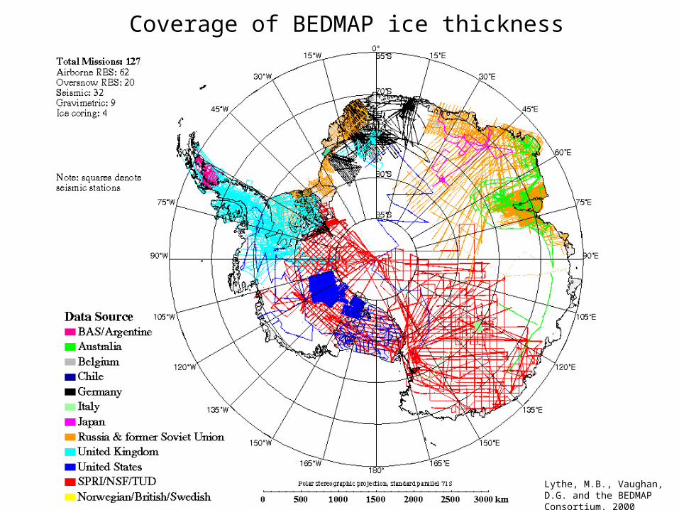
Coverage of BEDMAP ice thickness
Lythe, M.B., Vaughan, D.G. and the BEDMAP Consortium. 2000

Modeling community inputs.
IceBridge aims to collect remote sensing data to improve predictive models of sea level rise:. Altimetry measurements, · Ice sheet and sea ice thickness, structure and extent;· Bed topography underlying land-based ice;· Bathymetry beneath floating ice shelves;· Snow accumulation and firn structure; and· Other geophysical constraints that will improve estimates of the geothermal and oceanic heatFlux
Your contribution: 1- Specific locations where models fail with current datasets.2- Collection pattern (gridded, flight tracks, SAR processing, flow-line). 3- Present vs future projection?
(ex: for PIG, bedrock can be collected upstream of ice plain or near the current grounding line position)
Specific flights requests: you can request a specific flight by filing a mini-proposal to Sophie or Eric. Will be forwarded to Science Team for discussion. For
Antarctica campaign, happening until June 12th.
Mission website: http://www.nasa.gov/mission_pages/icebridge/