hycom and wavewatch iii advancing hurricane guidance€¦ · tolman, feb. 23, 2010 hurricane...
TRANSCRIPT

Tolman, Feb. 23, 2010 Hurricane Workshop @ NCAR, 1/23
HYCOM and WAVEWATCH III ® for
advancing hurricane guidance
Hendrik L. Tolman
Chief, Marine Modeling and Analysis Branch
NOAA / NWS / NCEP / EMC

Tolman, Feb. 23, 2010 Hurricane Workshop @ NCAR, 2/23
Overview
Why coupling?
Why HYCOM
Why WAVEWATCH III.
Progress at NCEP
HYCOM - HWRF.
HYCOM – WAVEWATCH III - HWRF.
Computational costs.
Risks.
Outlook.
Tolman, Feb. 23, 2010 Hurricane Workshop @ NCAR, 3/23
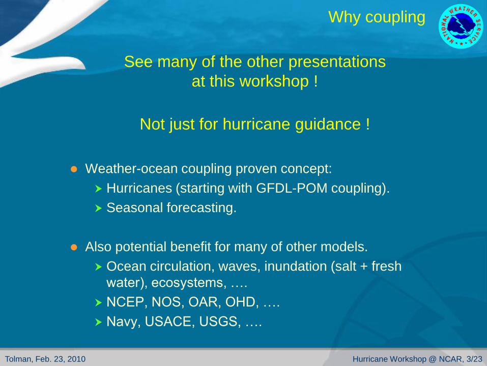
Why coupling
See many of the other presentations
at this workshop !
Not just for hurricane guidance !
Weather-ocean coupling proven concept:
Hurricanes (starting with GFDL-POM coupling).
Seasonal forecasting.
Also potential benefit for many of other models.
Ocean circulation, waves, inundation (salt + fresh
water), ecosystems, ….
NCEP, NOS, OAR, OHD, ….
Navy, USACE, USGS, ….

Tolman, Feb. 23, 2010 Hurricane Workshop @ NCAR, 4/23
Why coupling
Wind waves are at the center of many of the
physical processes at the water-air interface.
Impact all fluxes, fluxes linked through sea spray.
Waves as direct source to TKE in air and water.
Non-local momentum transfer from atmosphere to ocean.
Forcing inside boundary layers, not only at the interface.
This is not new:
Decade of experience with impact on surface stresses for
weather modeling (ECMWF).
Decades of experience with impact of currents on waves.
Decades of experience with wave-surge and wave-
circulation linkage

Tolman, Feb. 23, 2010 Hurricane Workshop @ NCAR, 5/23
Why HYCOM
GFDL-POM and HWRF-POM are proven
systems. Why transition to HYCOM?
Scientific / technical issues:
Use operational RTOFS-Atlantic model for IC and BC:
Realistic real-time ocean (previous TCs).
Full ocean model:
Separate support community.
Solid base for physics based improvement.
Management of NCEP production suite:
No support (at NCEP) for further development of POM
based system.
Cannot afford to maintain multiple systems (if not MME).

Tolman, Feb. 23, 2010 Hurricane Workshop @ NCAR, 6/23
Why WAVEWATCH III
WAVEWATCH III is NCEPs main wave model:
Consolidation of all wave modeling in single model since
mid 1990’s
Traditional deep ocean, applicable to surf zone.
Close to single wave scale.
Has become a de-facto community operational and
research model.
Traditional use as a guidance model at NCEP, but also to
be supported by NCEP for local applications at WFOs and
any interested partner:
“Workstation WW III” under development.

Tolman, Feb. 23, 2010 Hurricane Workshop @ NCAR, 7/23
NCEP progress
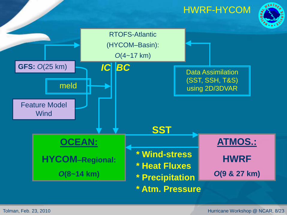
HYCOM – HWRF
System reaching maturity at the end of 2008.
Initial development not with operational HWRF:
Needing H050 baseline for sensible coupling.
HR issues.
Parallel testing with frozen system for 2009 Atlantic Hurricane Season:
Goal: Show potential impact of POM-HYCOM replacement.
Compare to operational HWRF.
In pre-ops testing for possible 2010 operational implementation.
Fully integrated with HWRF development path.
Goal: Replacing POM with HYCOM should do no harm.
Tolman, Feb. 23, 2010 Hurricane Workshop @ NCAR, 8/23
meld
ATMOS.:
HWRF
O(9 & 27 km)
OCEAN:
HYCOM–Regional:
O(8~14 km)
RTOFS-Atlantic
(HYCOM–Basin):
O(4~17 km)
IC
Feature Model
Wind
Data Assimilation
(SST, SSH, T&S)
using 2D/3DVAR
BC
SST
* Wind-stress
* Heat Fluxes
* Precipitation
* Atm. Pressure
GFS: O(25 km)
HWRF-HYCOM

Tolman, Feb. 23, 2010 Hurricane Workshop @ NCAR, 9/23
HWRF-HYCOM
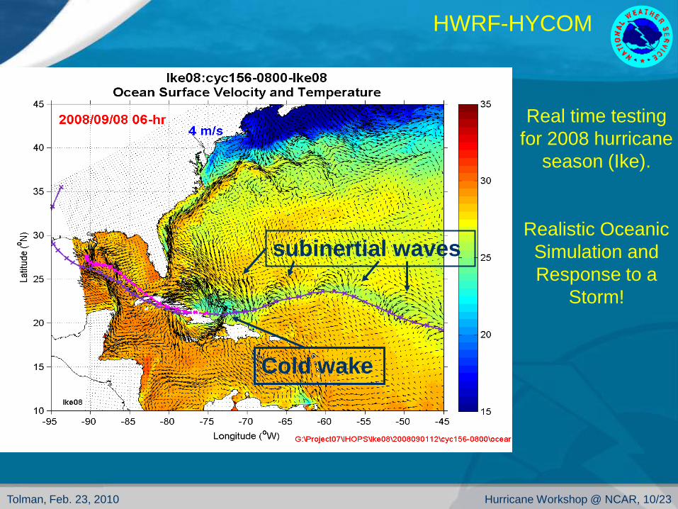
Tolman, Feb. 23, 2010 Hurricane Workshop @ NCAR, 10/23
subinertial waves
Cold wake
Real time testing
for 2008 hurricane
season (Ike).
Realistic Oceanic
Simulation and
Response to a
Storm!
HWRF-HYCOM

Tolman, Feb. 23, 2010 Hurricane Workshop @ NCAR, 11/23
Identical HWRF
HWRF-HYCOM
Overall 2009 real-time parallel results
Two populations due to several short weak systems
Green: NCO operational POM-HWRF
Black: parallel POM-HWRF
Red: parallel HYCOM-HWRF

Tolman, Feb. 23, 2010 Hurricane Workshop @ NCAR, 12/23
HWRF-HYCOM pre-ops testing
Name Date Wind Pressure Category
Fay (06L) 15 – 24 Aug. 2008 60 985 TS
Gustav (07L) 25 Aug. – 1 Sep. 2008 135 940 4
Hanna (08L) 28 Aug. – 7 Sep. 2008 75 977 2
Ike (09L) 1 – 14 Sep. 2008 125 935 4
Bill (03L) 15 – 24 Aug. 2009 115 945 4
Danny (05L) 26 – 29 Aug. 2009 50 1005 TS
Erika (06L) 1 – 4 Sep. 2009 50 1004 TS
Fred (07L) 7 – 12 Sep. 2009 105 958 3
Henri (10L) 6 – 8 Oct. 2009 45 1005 TS
Ida (11L) 4 – 10 Nov. 2009 90 978 2

Tolman, Feb. 23, 2010 Hurricane Workshop @ NCAR, 13/23
No GFS res. incr.
HWRF-HYCOM
2010 pre-ops testing
Green: Operation 2009 HWRF model.
Red: New baseline HWRF model (H050)
Purple: 2010 test package (POM) (H054)
Orange: 2010 test package (HYCOM) (HYC2)

Tolman, Feb. 23, 2010 Hurricane Workshop @ NCAR, 14/23
NCEP progress
HYCOM – WAVEWATCH III – HWRF
Framework for three-way coupling build at NCEP.
Transitioned to URI for insertion of coupling physics.
Intended for real-world testing at end of year.

Tolman, Feb. 23, 2010 Hurricane Workshop @ NCAR, 15/23
URI / ESRL / NCEP / NRL
Coupled Hurricane-Wave-Ocean Framework
Implemented in GFDL model in a research mode.
Being implemented in HWRF-WW3-HYCOM.
(from Isaac Ginis)

Tolman, Feb. 23, 2010 Hurricane Workshop @ NCAR, 16/23
NCEP progress
“Workstation WW III”
Coupled ADCIRC-WW III capability, integrated in
operational WW III, can be run locally.
Adding NOS ADCIRC models to NCO operation.
HFIP funding through NOS.
Work now starting, test version available 2011.
First as stand-alone coupled model.
Could become blueprint for coupled wave-surge modeling in
coupled HWRF.

Tolman, Feb. 23, 2010 Hurricane Workshop @ NCAR, 17/23
Computational costs
Is coupling too expensive for operations ?
model processes
HWRF 91
HYCOM 30
WW III 6
assigned resources
in test setup
HYCOM requires significantly
less resources than HWRF.
POM typically is run on only one
process:
HYCOM much more
expensive than POM, but
this does not mean that
HYCOM dominates
resource requirements.
Adding the wave model later
requires only 20% of HYCOM
resources or 7% of HWRF
resourcesBut this is not the
whole story, what is
the run time ?

Tolman, Feb. 23, 2010 Hurricane Workshop @ NCAR, 18/23
Computational costs
Is coupling too expensive for operations ?
There are 20 nodes available for operational HWRF model.
We believe we can fit HYCOM-HWRF on 4 nodes fitting in
the allotted time window.
HYCOM-HWRF and a fifth storm as requested by TPC
can be implemented operationally.
Still working on optimization of HYCOM-HWRF.
Significantly less efficient than POM-HWRF (2 nodes).
Mostly related to different hardware optimization
approaches needed for the two models.
By 2011, we expect to be able to run on 3 instead of 4
nodes, generating space for new model additions in
2011 (requires < 15% speed up).

Tolman, Feb. 23, 2010 Hurricane Workshop @ NCAR, 19/23
Computational costs (future)
HYCOM
1/12° resolution should be sufficient for foreseeable future,
Consistent with present reduced RTOFS grid.
Consistent with planned RTOFS-Global (NE Pacific or
even global coupled modeling capability).
Relative need for resources likely to be reduced.
WAVEWATCH III
3x speed up possible with true relocatable grid.
2.5x – 5x slow down expected for physics optimization.
Scaling like HWRF expected when adding grids.
Highly optimized on various architectures / resources.
Likely to remain small part of needed effort.
Workstation WW III alows for efficient landfall coupling.
Tolman, Feb. 23, 2010 Hurricane Workshop @ NCAR, 20/23
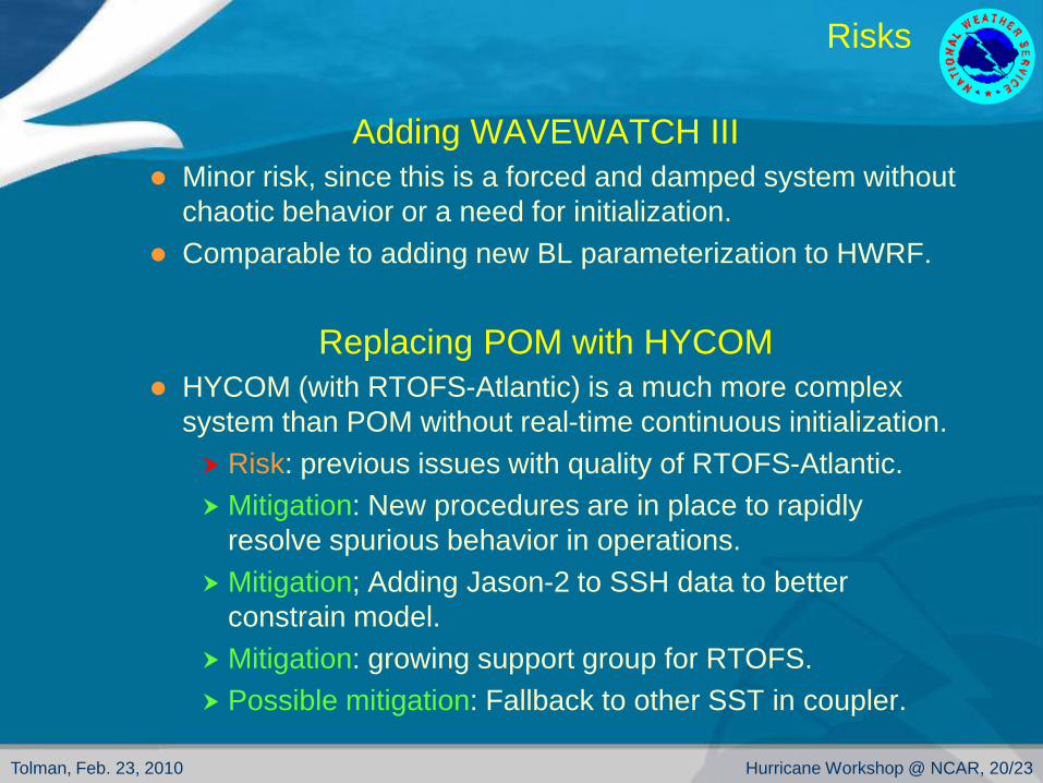
Risks
Adding WAVEWATCH III
Minor risk, since this is a forced and damped system without
chaotic behavior or a need for initialization.
Comparable to adding new BL parameterization to HWRF.
Replacing POM with HYCOM
HYCOM (with RTOFS-Atlantic) is a much more complex
system than POM without real-time continuous initialization.
Risk: previous issues with quality of RTOFS-Atlantic.
Mitigation: New procedures are in place to rapidly
resolve spurious behavior in operations.
Mitigation; Adding Jason-2 to SSH data to better
constrain model.
Mitigation: growing support group for RTOFS.
Possible mitigation: Fallback to other SST in coupler.

Tolman, Feb. 23, 2010 Hurricane Workshop @ NCAR, 21/23
Risks
HYCOM cont’ed
HYCOM-HWRF coupling is more complex:
Risk: Small support group for coupled system.
Mitigation: Dedicated group expanded from 1 to 3.
Mitigation: Community support (FSU, AOML, …).
Risk: Complexity of system may make it more prone to
failure.
Reality: This system will be fully supported in-house, the
present POM base system is not.
Reality: This system was robust in parallel testing.
Possible mitigation: Fallback to other SST in coupler.

Tolman, Feb. 23, 2010 Hurricane Workshop @ NCAR, 22/23
Outlook
Coupling in hurricane guidance
excites me because:
It provides road to potential improvement of hurricane
guidance with solid roots in physics.
It constrains the underlying physical problems by linking flux
parameterizations.
It provides a road to improvement for “secondary” hurricane
issues related to ocean circulation, wind waves, inundation
etc.
Will these remain “secondary” (e.g., inundation) ?
It fosters collaborations.
It helps NOAA to focus more on oceans.

Tolman, Feb. 23, 2010 Hurricane Workshop @ NCAR, 23/23