hydrogeomorphic evaluation of ecosystem restoration and
TRANSCRIPT

Hydrogeomorphic Evaluation ofEcosystem Restorationand Management Options for
James CampbellNational Wildlife Refuge
Prepared For:
Hawaiian and Pacific Island Refuge Complex
U. S. Fish & Wildlife Service Region 1
Honolulu, Hawaii
Greenbrier Wetland Services
Report 13-01
Adonia R. Henry
Leigh H. Fredrickson
January 2013

ii
Suggested citation:Henry, A. R., and L. H. Fredrickson. 2013. Hy-drogeomorphic evaluation of ecosystem restora-tion and management options for James Camp-bell National Wildlife Refuge. Prepared for U. S. Fish and Wildlife Service, Region 1, Honolulu, HI. Greenbrier Wetland Services Report 13-01, Blue Heron Conservation Design and Printing LLC, Bloomfield, MO.
(Note: Every attempt has been made to use correct Hawaiian spelling of Hawaiian names. An exception to this occurs in the literature cited and some maps where the original authors did not use diacritical marks in their titles and/or GIS database.)
Photo credits: Cover: aerials, George Fisher, USFWS;Koloa, Gregory Koob, NRCS;Nene, Mike Neal
Adonia R. Henry, Leigh H. Fredrickson, Jack Jeffrey http://www.jackjeffreyphoto.com/, Mike Neal http://mneal.net/NealStudios/hawaiian-native-bird/ ;USFWS staff; Jim Denny http://www.kauaibirds.com; Ameri-can Memory, Library of Congress, http://memory.loc.gov/ammem/browse/ListSome.php?category=Environment,+Conservation
Mickey E. Heitmeyer, PhD
Greenbrier Wetland Services
Route 2, Box 2735
Advance, MO 63730
www.GreenbrierWetland.com
Publication No. 13-01
This publication printed on recycled paper by

iii
EXECUTIVE SUMMARY ..................................................................................... v
INTRODUCTION ................................................................................................ 1
THE HISTORICAL JAMES CAMPBELL ECOSYSTEM .................................... 5 Geology and Geomorphology ...................................................................... 5 Soils ......................................................................................................... 7 Topography and Elevation .......................................................................... 10 Climate and Hydrology .............................................................................. 10 Historical Flora and Fauna ......................................................................... 15 Overview ........................................................................................ 15 Characteristics of Historical Vegetation Communities .................... 15 Distribution of Historical Vegetation Communities ....................... 20 Key Animal Communities .............................................................. 23
CHANGES TO THE JAMES CAMPBELL ECOSYSTEM ................................. 27 Early Settlement and Land Use Changes .................................................... 27 Contemporary Landscape and Hydrology Changes .................................... 29 Changes in Plant and Animal Populations .................................................. 36 Establishment and Management of JCNWR .............................................. 39
OPTIONS FOR ECOSYSTEMRESTORATION AND MANAGEMENT .......................................................... 45 Summary of HGM Information ................................................................. 45 Recommendations for Ecosystem Restoration and Management ..................................................................... 46
CONTENTS

iv
Scientific information needs ....................................................................... 56 Key Baseline Ecosystem Data ......................................................... 56 Changes in Water Regimes and Flow Patterns ................................ 57 Long-term Changes in Vegetation and Animal Communities ......... 57
ACKNOWLEDGEMENTS ................................................................................. 59
LITERATURE CITED ........................................................................................ 61
APPENDICES ..................................................................................................... 67
1 CONTENTS, cont’ d.
Jack Jeffrey

Geo
rge
Fish
er, U
SFW
S
v
EXECUTIVE SUMMARY
This report provides an evaluation of ecosystem restoration and management options for James Campbell National Wildlife Refuge (JCNWR) on the northeastern Kahuku coastal plain of O‘ahu, Hawai‘i using Hydrogeomorphic Methodology (HGM). This HGM evaluation assesses pre-historical (as available), historical, and current information about geology and geomorphology, soils, topography, hydrology and climate, plant and animal communities, and physical anthropogenic modifications of the Kahuku coastal plain. Recommendations for management and restoration of ecosystem functions are based on the synthesis of this information.
JCNWR encompasses 1,085 acres along 2 miles of shoreline and 1 mile inland of low elevation coastal habitats. The surficial geology of the refuge reflects the complex geological history of the island. The refuge is characterized by Holocene-derived alluvium and calcareous sand as well as lithified dunes and limestone formed during the Pleistocene. Soil maps indicate a somewhat banded distribution of soil types with deep sandy beach and dune soils along the shoreline, poorly-drained clay soils inland of the limestone outcrops, and deep silty clay soils on alluvial fans. LiDAR topographic surveys were completed for the refuge during 2007, providing detailed elevational information for some areas of the refuge.
The climate of the Kahuku coastal plain is subtropical, dominated by trade winds, low average annual precipitation (40 inches) received mostly during the winter months, and a year-round growing season. Groundwater discharge and surface water runoff (during high precipitation events) are the primary sources of water for wetland habitats on the Kahuku coastal plain. Steam flow characteristics are influenced by the seasonally and annually dynamic precipitation in the ‘Ō‘io watershed. Flood mapping and recent rainfall events indicate substantial portions of the Kahuku coastal plain are inundated

vi
during high precipitation events.
Archeological studies indicate that extensive lowland forests dominated by hala trees (Pandanus tectorius), loulu palm trees (Pritchardia sp.), ‘a‘ali‘i (Dodonea viscosa), Kanaloa sp., koa (Acacia koa), and ‘ōhi‘a (Metrosideros sp.) occurred on the windward and northern sides of the island of O‘ahu prior to Polynesian settlement. Based on oral Hawaiian traditions, the Kahuku area was well known for its extensive groves of hala trees. Early written accounts refer to the “fertile” landscape on the Kahuku coastal plain
Evolving in the absence of mammals, many endemic species of Hawaiian birds and insects became extinct following Polynesian settlement. For example, flightless ibises, up to 18 species of flightless rails (Porzana sp.), and at least eight species of flightless waterfowl (moa-nalos and true geese) occurred throughout the Hawaiian Islands. Several species of eagles, hawks, and owls, which are known only from the fossil record, have also been extirpated from the Hawaiian Islands. Rats, first introduced to Hawai‘i by Polynesian voyagers, have had a devastating impact on Hawaii’s native flora and fauna. Introductions of non-native plant and animal species increased after Western contact, resulting in more destructive impacts to Hawaii’s native flora and fauna. At the present time, many extant species of native plants and animals have low populations and/or reduced distributions.
Contemporary data on physical features, hydrology, and plant and animal communities chronicle the history of land and ecosystem changes at and near the refuge from the pre-Polynesian settlement and pre-Western contact periods. These data provide perspective on when, how, and why alterations have occurred to ecological communities and processes on the refuge. Land use alterations during the Polynesian period may never be fully known, but likely included ditches and berms to transport and hold water for taro lo‘i, and clearing of forested areas for villages and agriculture. The major changes in the JCNWR ecosystem since the late 1700s have been: 1) alterations in the distribution, chronology of inputs, and volume of surface and groundwater, especially during sugarcane production; 2) decreases in the extent of wetland habitats on the Kahuku coastal plain; 3) alteration of native coastal strand, lowland forest, and wetland communities by

vii
clearing land for domestic livestock grazing, agricultural and military developments, and the establishment of non-native and invasive species; 4) decreased native species diversity; 5) altered topography including many levees, roads, ditches, borrow areas, and water-control structures that block surface flow on JCNWR; and 6) altered timing, velocity, and magnitude of natural hydrologic inputs because of highway and ditch infrastructure that form constriction points, becoming conduits for rapid scouring water movements.
Through a lease from the Estate of James Campbell, JCNWR was established during 1976 with the Ki‘i and Punamanō units to protect habitat for four species of endemic Hawaiian waterbirds. The focus on the James Campbell area was tied to the Ki‘i unit, where the sugarcane settling basins from the Kahuku Sugar Mill provided limited flooded habitat. Waterbirds were attracted to these settling basins because of the reduced availability of wetland habitats in the highly disrupted coastal zones throughout the Hawaiian Islands. Because the settling ponds were not designed to optimize wetland functions and processes, management of the highly disrupted Ki‘i unit has been complex and full of challenges since the establishment of the refuge. The water control infrastructure from the sugarcane production area was rehabilitated during the 1980s, but none of this work was based on analyses of geologic and hydrologic conditions. Rehabilitation included excavating deeper basins, repairing and raising existing dikes, installing new water control structures and pumps, and creating nesting islands. None of these changes recognized topography, soil characteristics (e.g., texture or salinity), or the presence and volume of groundwater discharge.
Early habitat management was limited by a poor understanding of native waterbird life history and native plant germination requirements, poor water control capability, poor water quality, inadequate and underpowered equipment, and limited management budgets. Following refuge establishment, management emphasis was on capturing water and preventing predation rather than promoting variability in seasonal hydrologic conditions, which is a primary management objective for productive wetland management. Given the potential for heavy predation by introduced mammals, early management strategies focused on maintaining permanent
viii
deepwater to restrict predator access. This resulted in more permanent water with relatively steep-sided nesting islands surrounded by moats. The ability to manipulate water for plant community development was compromised by the inability to remove water from moats, as well as poorly sized and sited water control structures.
Some impoundments at Ki‘i were eventually managed with annual drawdowns, soil tillage, and fire to establish conditions suitable for wetland plant communities that would produce food and cover to enable the reproduction and survival of endangered and migrant waterbirds. No active management occurred at Punamanō until the late 1980s when a flapgate was installed to reduce salt water inflow from the aquaculture facilities. Unfortunately, invasive plant and animal species had encroached on native habitats throughout the Kahuku coastal plain and in the ‘Ō‘io watershed. To address the invasive plant and animal issues, integrated pest management actions, including mechanical and chemical control methods, have been used to reduce their abundance. Invasive vegetation has been reduced extensively at the intensively managed Ki‘i units compared to its condition when acquired by USFWS. Expanded removal of non-native vegetation during the 2000s has also restored seasonally flooded wetlands near Punamanō.
Although greatly reduced in abundance compared to historical conditions, remnant native plant communities occur on JCNWR. Abiotic conditions associated with these native plant communities can help inform future restoration and management actions. Native resident animal species still present include four species of federal- and state-listed endangered Hawaiian waterbirds, auku‘u (black-crowned night herons), pueo (Hawaiian short-eared owls), honu (green sea turtles), ‘īlioholoikauaua (Hawaiian monk seals), and several species of seabirds, fishes, and aquatic invertebrates.
The future condition of the JCNWR ecosystem is, and will continue to be, affected by land uses surrounding the refuge and within the watershed, including flood control efforts and predicted impacts of climate change and sea level rise. The impetus for establishing JCNWR was to provide habitat for four endangered species of Hawaiian waterbirds. Since establishment, the approved refuge boundary has expanded beyond the area of the Ki‘i and Punamanō to encompass

ix
1,085 acres of coastal strand, wetland, and lowland habitats. Refuge goals, through the recently approved Comprehensive Conservation Plan, have become more holistic and include restoration and management of diverse native habitats to benefit native Hawaiian plants and animals, as well as migratory shorebirds and waterfowl. Consequently, and according to USFWS policy (601 FW 3), future management of JCNWR must attempt to maintain and restore ecosystem processes and functions that support native habitats to provide resources used and required by native animal species.
The future management of JCNWR should seek to meet the following goals:
1. Protect and restore the physical and hydrologic character of the Kahuku coastal plain, including collaboration with the community of Kahuku to develop ecologically sound inte-grated flood management measures..
2. Restore the natural topography, water regimes, and physical integrity of surface flow and groundwater flow patterns, especially into and across the Punamanō portion of the Kahuku coastal plain and newly acquired lands.
3. Restore and/or manage for the diversity, composition, dis-tribution, and regenerating mechanisms of native wetland, coastal strand, and lowland forest vegetation communities in relation to topographic and geomorphic landscape position.
4. Provide functional complexes of diverse habitats with abundant and available resources required by a) endemic Hawaiian waterfowl and waterbirds during all life history stages, b) migratory waterfowl and shorebirds during fall post-migration, winter, and spring pre-migration periods, and c) other native species during appropriate life history stages (e.g., turtle and seabird breeding).
Specific possible actions to address each of the above recommendations (given current constraints) are fully described in the report.
Future management of JCNWR should include carefully designed, regular monitoring as well as management-oriented

Adonia Henry
x
research projects to determine how ecosystem structures and functions are changing, regardless of whether restoration and management options identified in this report are completed. Ultimately, the success in restoring and sustaining communities and ecosystem functions at JCNWR will depend on how well the physical and hydrological integrity of the Kahuku coastal plain and ahupua‘a are protected and how well ecological processes can be restored or mimicked by management actions. Surrounding land uses and flood control efforts create limitations on the ability to make some system changes unless there is collaboration with other landowners, and the uncertainties of climate change and sea level rise must be taken into account. Also, best techniques for controlling or reducing introduced plant species and restoring lowland forest are not entirely known. Especially critical scientific information and monitoring needs for JCNWR include:
1. Key baseline ecosystem data on a) soil characteristics, b) current vegetation inventory and mapping, c) seasonal movements, habitat use, distribution, and timing of use for endangered waterbirds, d) species abundance and habitat use by other animal species, and e) wetland hydroperiod (depth, duration, and extent of flooding) associated with precipitation events and stream flow.
2. Long-term evaluation of surface and groundwater param-eters and the effects of restoration and management actions that restore or mimic natural water regimes.
3. Long-term changes in vegetation and animal communities in response to management actions.

xi
Adonia Henry
Mike Neal
Mik
e N
eal

Adonia Henry
Ado
nia
Hen
ryAdonia Henry
xii
O'ahu National WildlifeRefuge Complex
Hawai'i
Maui
Kaua'i
Moloka'i
Lana'i
Kaho'olawe
O'ahu
Ni'ihau
James CampbellNational Wildlife Refuge
Main Hawaiian Islands
Pacific Ocean
0 40 80 120 16020 Miles
O
O'ahu ForestNational Wildlife Refuge
Pearl HarborNational Wildlife Refuge
0 3.5 7 10.5 141.75 Miles
Figure 1. General location of James Campbell National Wildlife Refuge on the island of O‘ahu, Hawai‘i.
1
INTRODUCTION
James Campbell National Wildlife Refuge (JCNWR), part of the O‘ahu National Wildlife Re-fuge Complex, is located on the Kahuku coastal plain near the northern tip of the island of O‘ahu (Figure 1 and Figure 2). The refuge was established in 1976 to: “preserve habitat vital to four rare and endangered species of waterbirds” and, “provide habitat for other shorebirds and waterfowl on the island of O‘ahu” (USFWS 2011a). The James Campbell National Wildlife Expansion Act of 2005 (Public Law 109-225) expanded the boundary of the refuge to include 1,085 acres for the purposes of 1) permanently protecting endangered species habitat, 2) improving the management of the refuge, and 3) promoting biological diversity for federally threatened and endan gered species including endangered Hawaiian waterbirds, migratory shorebirds, migratory waterfowl, breeding seabirds, endangered and native plant species, endangered monk seals, and breeding green sea turtles. Originally encompassing approximately 150 acres of land leased from the Estate of James Campbell, this refuge currently contains 934 acres in fee title. An additional 151 acres are part of the acquisition plan with negotiations underway for its purchase. Once this remaining area is acquired, the 1,085 acres approved for acquisition will be complete.
The Kahuku coastal plain is rich in cultural and natural resources. The area supported numerous Polynesian villages prior to western contact and the first written descriptions of the area noted its “fertile landscape” and abundant resources. The Kahuku
James CampbellNational Wildlife Refuge
O0 0.5 1 1.5 20.25Miles
Figure 2. USGS topographic map of the Kahuku coastal plain showing the location of James Campbell National Wildlife Refuge in relation to wetland areas, streams, roads, and other features.
2 Henry and Fredrickson
coastal plain was an oasis within the ‘Ō‘io watershed where fresh surface and ground water inputs created extensive wetland habitats across the otherwise dry, windy, and salt influenced coastal region. Ecological resources in the coastal plain supported a diverse assemblage of plant communities and abundant populations of many native fish and wildlife species. Several endemic plant and animal species have gone extinct and others are greatly reduced in distribution and/or abundance.
Alterations to the Kahuku coastal plain began with the arrival of Polynesian voyagers and the eventual Polynesian settlement of windward O‘ahu. One of the earliest human induced changes to the natural environment on O‘ahu was the introduction of rats and pigs to an island environment otherwise free of terrestrial mammals. Rats are known to prey on ground nesting birds and eat seeds of native plants and are suspected to have significantly altered the
composition of historical native lowland habitats, especially native forests. Polynesians also introduced several plant species for food or utilitarian purposes, but very few of those species have become nuisance species. Some of the first hydrologic changes included ditches and berms that were dug to transport and hold water to grow taro (Colocasia esculenta).
Alteration of the native environments began as early as 1,600 years ago, but most of the substantial changes to O‘ahu and the Kahuku coastal plain have occurred since 1778 following Western contact. These changes included the introduction of European boars, goats, and cattle that grazed native habitats, clearing of native habitats for grazing and sugarcane production, and the introduction of grasses for improved cattle forage. Numerous other plant species were introduced to the Hawaiian Islands that have had a profound effect on species composition and ecological processes of native habitats. Chinese markets for sandalwood

Adonia Henry
3HGM EVALUATION OF ECOSYSTEM RESTORATION FOR JAMES CAMPBELL NWR
resulted in altered species composition in native Hawaiian forests, increased pathways for the spread of invasive species, and indirectly altered hydrologic processes within watersheds. The growing and pro-cessing of sugarcane and infrastructure required to support the industry further altered the topography, soils, and surface and subsurface water availability of the Kahuku coastal plain. Developments, including a World War II military base and the Turtle Bay Resort, have filled and drained historical wetland habitats. Recent construction of aquaculture facilities has further modified topography, soils, and water quality of the Kahuku coastal plain.
JCNWR conserves important coastal and lowland habitats on the island of O‘ahu, and refuge management has focused on providing wetland habitat for endemic Hawaiian waterbirds. JCNWR is considered a core wetland area by USFWS (2011b) with habitats essential to the recovery of four species of endemic Hawaiian waterbirds, all of which are listed as state and federally endangered. It is also within a priority focus area identified by the Hawai‘i Wetland Joint Venture (HWJV 2011).
During 2011, the USFWS completed a Comprehensive Conservation Plain (CCP) for JCNWR. The CCP process sought to articulate the management direction for the refuge for 15 years and developed goals, objectives, and strategies to define the role of the refuge and its contribution to the island and regional landscapes. Design and implementation of some of the goals and objectives identified in the CCP now are being facilitated by an evaluation of ecosystem restoration and management options using Hydrogeomorphic Methodology (HGM) (Heitmeyer 2007). HGM is commonly used to evaluate ecosystems on refuges (e.g., Heitmeyer and Fredrickson 2005, Heitmeyer and Westphall 2007, Heitmeyer et al. 2009, Heitmeyer et al. 2010, Heitmeyer et al. 2012).
The HGM approach provides a historical context to understand the physical and biological formation, features, and ecological processes of lands within JCNWR and the surrounding region. This historical assessment then provides the foundation, or baseline condition, to determine what changes have occurred in the abiotic and biotic attributes of the ecosystem and how these changes have affected ecosystem structure and function and ultimately the capability of the area to restore and sustain fundamental ecological processes and resources. To accomplish this assessment, the HGM obtains and analyzes historical and current information about: 1) geology and geomorphology; 2) soils; 3) topography and elevation; 4) hydrology
and climate; 5) plant and animal communities; and 6) physical anthropogenic features of the refuge and surrounding lands.
This report provides HGM analyses for JCNWR with the following objectives:
1. Identify the pre-Polynesian settlement (as available) and pre-Western contact ecosystem condition and ecological processes at the Kahuku Coastal Plain near JCNWR.
2. Evaluate changes in the ecosystem from the pre-Western settlement period with specific reference to alterations in hydrology, vegetation community structure and distribution, and resource availability related to key fish and wildlife species.
3. Identify restoration and management options and ecological attributes needed to success-fully restore and manage specific habitats and ecosystem functions in the JCNWR region.
With the exception of early explorer accounts, no written records are available to assess pre-Polynesian or Polynesian ecosystem conditions. Oral traditions and archeological studies provide limited information on the pre-Polynesian and Polynesian periods and are included when available. Oral traditions were very important in ancient Hawaiian culture and ‘ōlelo no‘eau (Hawaiian proverbs) have been preserved through generations. Those relating to the Kahuku area and pertinent to the HGM assessment are referenced. The resource-use concept of ahupua‘a, similar to the current-day watershed concept, was developed rather late during the prehistorical Hawai‘i period (Ziegler 2002) and is also included as part of the HGM assessment. The HGM assessment also uses descriptions of early Western explorers representing the historical pre-European ecosystem condition. The land use changes that have the best documentation since European contact are those associated with the sugarcane industry beginning in the late 1880s.

4 Henry and Fredrickson
Map, old photos from American Memory, Library of Congress, American Environ-mental Photographs Collection
Mike Neal
Mike Neal

5��Geologic Map of the State of Hawai‘i
EXPLANATION
O‘AHU
Younger alluvium (Holocene and Pleistocene)
WAI‘ANAE VOLCANO
Older alluvium (Pleistocene and Pliocene(?))
Wai‘anae Volcanics (Pliocene)
Kolekole Member
Pālehua Member
Kamaile‘unu and Lualualei Members
KO‘OLAU VOLCANO
Honolulu Volcanics (Pleistocene)
Ko‘olau Basalt (Pleistocene(?) and Pliocene)
Kailua Member
Fault, dotted where buried
Radiometric age Dike
0 10 20 km
158°15’ 158°00’158°7’30” 157°45’157°52’30” 157°37’30”21°45’
21°37’30”
21°30’
21°15’
21°22’30”
Mt.Ka‘ala
Honolulu
Kailuacaldera
Pālol
o Va
lley
KO‘O
LAU RANGEKolekole
Pass
LualualeiValley N
u‘uanu
Pal i
Moloka‘i
O‘ahu
Kauai
Wai‘anaeSlump
Nu‘uanuSlide
Figure 9 Figure 9. Geologic map of O‘ahu, generalized from this publication’s digital map database. Geology from Stearns (1939) and J.M. Sinton (this map). Inset bathymetric map from Eakins and others (2003).Figure 3. Geologic map of the island of O‘ahu (from Sherrod et al. 2007:19).
THE HISTORICALJAMES CAMPBELL ECOSYSTEM
GEOLOGy ANd GEOMORPHOLOGy
The Emperor Seamount Chain and the younger Hawaiian Archipelago formed (and are forming) as the Pacific lithospheric plate drifts over a convective plume or “hotspot” in the mantle of the earth. The Pacific plate has drifted west-northwestward approximately 3.5 in/yr while the hotspot has remained relatively fixed for the past 40 million years (Clague 1998). The plume of hot rock that forms the hotspot has created about 107 separate shield volcanoes that have moved from their point of origin by the drifting Pacific plate (Clague and Dalrymple 1987). The rate of lava eruption and position of the volcano’s summit relative to sea level determine the eruptive activity, composition, and morphology of each volcano (Clague 1998). The Hawaiian Archipelago currently includes 15 volcanoes across 8 main islands (Ni‘ihau, Kaua‘i, O‘ahu, Moloka‘i, Kaho‘olawe, Lāna‘i, Maui, and Hawai‘i) and numerous volcanoes, mostly submerged, older than 7 million years in the Northwestern Hawaiian Islands.
The island of O‘ahu, formed by the Wai‘anae and Ko‘olau shield volcanoes, is the third oldest main Hawaiian island. As shield volcanoes build, the Pacific plate warps under the weight of the multiple, massive lava f lows causing the shield volcanoes to subside. Subsidence and other geologic processes, including slumping and landslides due to slope instability, chemical weathering, erosion, sedimentary deposition, and eustatic f luctuation of sea level, have shaped the current land masses of the
Hawaiian Islands. The prominent Wai‘anae and Ko‘olau Mountains on O‘ahu are the remnants of the rims of the shield volcanoes.
The Ko‘olau Volcano, the younger of the two volcanoes, extends northwest along the eastern portion of the island and is comprised of Ko‘olau basalt and Honolulu volcanics (Figure 3). The age of the Ko‘olau basalt ranges from 3 to 1.5–2 Ma (million years ago), primarily from the Pliocene (Sherrod et al. 2007). A northwest-trending rift zone, defined by a

6 Henry and Fredrickson
Table 1. Driller’s well log and general characteristics of rocks for Well B drilled at the Kahuku Sugar Mill during 1936. Data compiled from Stearns and Vaksvik (1938).
Depth (ft) Driller’s Well Log General Characteristics of the Rocks 0-6 Sand mixed with soft
coral rock (Rs and Pls) Unconsolidated marine calcareous sediments consisting mostly of beach sand; and consolidated calcareous sediments consisting of reef limestone marls and other sediments deposited by different stands of the sea.
6-39 Medium hard coral rock (Pls and probable Pd)
Consolidated calcareous sediments consisting of reef limestone marls and other sediments deposited by different stands of the sea; and consolidated calcareous dunes consisting of eolian limestone.
39-43 Hard rock (Pls) Consolidated calcareous sediments consisting of reef limestone marls and other sediments deposited by different stands of the sea
43-53 Sticky brown clay (Pa and Pls)
Consolidated and partly consolidated noncalcareous deposits consisting of older alluvium, ancient talus, and landslide deposits; and consolidated calcareous sediments consisting of reef limestone marls and other sediments deposited by different stands of the sea
53-55 Medium hard coral rock (Pls)
See description for 39-43 ft
55-82 Sticky brown clay (Pa and Pls)
See description for 43-53 ft
82-147 Various sticky muds and clays (Pa)
Consolidated and partly consolidated noncalcareous deposits consisting of older alluvium, ancient talus, and landslide deposits
147-162 Hard, medium, & soft corals (Pls)
See description for 39-43 ft
162-313 Rock, gravel, and gravel mixed with rock (Tkb)
Grey, blue, red, and black jointed, dense to very vesicular, holocrystaline and microcrystalline, aphanitic and porphyritic effusive basalt poured out of fissures and vents in rapid succession.
dike complex on the east side of the Ko‘olau Range, extends the entire length of the range (Stearns 1939). The Honolulu volcanics located at the southern portion of the Ko‘olau Range (e.g., Diamond Head) are the result of rejuvenated-stage volcanism following the end of the active shield volcano dating from 1.1 to 0.1 Ma (Sherrod et al. 2007).
Younger sedimentary deposits from the Holocene and Pleistocene, including sand dune deposits, beach
sand, alluvium, and limestone line the northern coastal shore of O‘ahu between the Ko‘olau basalt and the Pleistocene calcareous reef rock and marine sediment (Figure 4). Wells drilled near the Kahuku sugar mill generally had stratified layers of calcareous reef limestone (coral), calcareous dune sediments from eolian limestone (sand), and noncalcareous deposits of alluvium (sticky mud) down to a depth of 160 to185 ft below the surface (Stearns and Vaksvik
1938). These sedimentary deposits were underlain by Ko‘olau basalt to the depth of the well, approximately 300 ft below the surface (Table 1). In contrast, a well drilled near Kahuku Point during 1933 had only hard and soft coral (calcareous reef limestone marl sediments) down to 135 ft below the surface before intersecting the Ko‘olau Basalt. Wells drilled south of JCNWR, near the Kahuku General Store, had thinner sedimentary deposits, ranging in depth from 40 to 88 ft below the surface (Stearns and Vaksvik 1938). Decomposed or partly decomposed basalt beneath the coastal plain sediments suggest that the deep Ko‘olau basalt was deeply weathered before submergence and formed an effective cap rock (Stearns and Vaksvik 1935).
The alternating marine and alluvial deposits are indicative of fluctuating periods of eustatic sea level rise when marine or terrestrial processes dominated. Relative sea level in Hawai‘i is dependent on the global eustatic trend, local oceanographic patterns, basin-scale meteorology, and localized flexure of the Pacific plate (Fletcher et al. 2012) and has fluctuated throughout the Quaternary period. Based on Thorium-230 ages of coral, Szabo et al. (1994) estimate that the last interglacial paleosea level on O‘ahu from 131 to 114 ka (thousand years ago) was longer than originally estimated and was at least 7 m higher than current levels. They also propose that O‘ahu was uplifted during the Quaternary at an average rate of 0.05 to 0.06 m per 103 years, resulting in an uplift corrected minimum sea level between 1 and

7HGM EVALUATION OF ECOSYSTEM RESTORATION FOR JAMES CAMPBELL NWR
Geology of Northeastern Oahuin the vicinity of
James Campbell National Wildlife Refuge
Approved Refuge Boundary
Geologic Unit
Kii - Open Water
Pd - Lithified Dune, Calcareous (Pleistocene)
Pls - Limestone (Pleistocene)
Ra - Alluvium (Holocene)
Rd - Sand Dunes, Calcareous (Holocene)
Rs - Beach Sand, Calcareous (Holocene)
Tkb - Koolau Basalt (Pleistocene and Pliocene)
O0 0.5 1 1.5 20.25 Miles
Pacific Ocean
Figure 4. Geology of northeastern O‘ahu in the vicinity of James Campbell National Wildlife Refuge. data from Sherrod et al. (2007) at http://pubs.usgs.gov/of/2007/1089/.
3 m higher than current levels. The sand deposits along the windward side of O‘ahu from Waimānalo to Kahuku are the result of carbonate deposition under the Kapapa Stand sea (3,000 years BP) which was approximately 2 meters higher than current sea levels (Feirstein and Fletcher 2004, Fletcher and Jones 1996). However, compared to other coastal areas on O‘ahu, the windward coast of O‘ahu north of Lā‘ie has a lower percentage of sand coverage due to the deep fringing shelf and small offshore sand fields that result from high energy environments and a limited watershed drainage (Conger et al. 2009).
‘Uko‘a Marsh, on the north shore of O‘ahu, formed about 7,400 years BP “when sea level began to stabilize and sediments accumulated on the costal shelf after a very rapid rise with the retreat of the continental glaciers” (Athens and Ward 1993:217). A similar estimate is inferred for the age of Punaho‘olapa Marsh based on a trench excavated
for archeological investigations (Walker et al. 1987). Punamanō and Ki‘i also were likely formed during the same time period.
The calcareous shoreline of the Kahuku plain is categorized as a solution bench, several hundred feet long and 40-80 ft wide. The solution bench is approximately 1 ft above mean sea level and may be completely exposed for up to 4 hours during low tide events (Kohn 1959). Potholes and the surface of the bench limestone are covered by algal turf.
SOiLS
The earliest known soil survey for the island of O‘ahu occurred during 1939 and was published following World War II (Cline 1955). Made primarily for agricultural interpretations, detailed field work based on soil survey transects between 1/8 and ½ mile

8 Henry and Fredrickson
Soil Types Mapped during 1939 on theKahuku Coastal Plain
O
Spatial and tablular data from Cline (1955)
Ca Catano loamy sandCe Catano sand, dune phaseH2d Hauula paddy soilsK2u Kawaihapai clay loamLm Laie clayLv Lowland peat and muckM2t Mokuleia clayM2u Moluleia clay loamM2v Mokuleia clay, shallow phaseM2w Mokuleia loam and fine sandy loamM2x Mokuleia silt loamMz Mamala clay, very shallow phaseP2b Pearl Harbor clayRh Rockland, Mamala soil materialWf Waialua silty clay
Soil Types within James CampbellNational Wlidfe Refuge
Approved Refuge Boundary
Figure 5. Soil types on the Kahuku coastal plain mapped during 1939. Soil map georeferenced from map sheet of Eastern O‘ahu (Cline 1955). Soil types within James Campbell National Wildlife Refuge are noted in the legend.
apart was completed for the Kahuku coastal plain. Later soil mapping completed during the 1970s was based on field work completed during 1965 and interpretations from aerial photographs, but the amount of field work is not noted (Foote et al. 1972). Given differences in methodologies and the substantial alterations to soil surfaces that occurred as a result of sugarcane production, the soil maps in Foote et al. (1972) are not as detailed as those from Cline (1955). Descriptions of soil types from both surveys are summarized below.
Soil maps for JCNWR and the surrounding area indicate a heterogeneous distribution of several poorly-drained clay soil types, clay and silt loams, coral outcrops, sand, and fill land. During the 1939 survey, soils mapped within the refuge boundary are dominated by Pearl Harbor, Mokulē‘ia, and Lā‘ie clays, Hau‘ula paddy soils, lowland peat and muck, loamy sand, sand, and coral limestone (Figure 5).
Smaller areas of Māmala clay, Mokulē‘ia loam and fine sandy loam, and Mokulē‘ia and Kawaihāpai clay loams, also occurred within the refuge boundary. Two prominent alluvial fans upslope from the Ki‘i and Punamanō wetlands are formed from Waialua silty clays.
Not including water, fill land, and coral outcrop, Foote et al. (1972) only mapped six soil types within JCNWR. During the 1965 survey, Kaloko clay was mapped on the area between the coral limestone and Waialua silty clay that contained four soil types during 1939. Other changes include reclassifying: 1) Catano sand and Catano loamy sand to Jaucus sand; 2) several soil types to Kea‘au clay, saline; 3) the area of Mokulē‘ia clay near Punamanō to Pearl Harbor clay; 4) a portion of the coral limestone to Pearl Harbor clay; and 5) adding fill land (Figure 6).
Jaucus and Catano sand typically occurs in narrow strips on coastal plains in the main Hawaiian

9HGM EVALUATION OF ECOSYSTEM RESTORATION FOR JAMES CAMPBELL NWR
NRCS Soil TypeBeaches
Coral Outcrop
Fill Land
Jaucus Sand; 0-15% slopes
Kemoo-Badland Complex
Kaena Clay; 2-6% slopes
Kaena Clay; 6-12% slopes
Kaena Stony Clay; 6-12% slopes
Kaena Very Stony Clay; 10-35% slopes
Kaloko Clay
Keaau Clay, Saline, 0-2% slopes
Kemoo Silty Clay; 2-6% slopes
Kemoo Silty Clay; 12-20% slopes
Lahaina Silty Clay; 3-7% slopes
Lahaina Silty Clay; 7-15% slopes
Paumalu Silty Clay; 3-8% slopes
Paumalu Silty Clay; 8-15% slopes
Paumalu Silty Clay; 15-25% slopes
Paumalu Silty Clay; 40-70% slopes
Pearl Harbor Clay
Water
Waialua Silty Clay; 0-3% slopes
Waialua Silty Clay; 3-8% slopes
Rock Land
Approved Refuge Boundary
Soil Types in the Vicinity of James Campbell National Wildlife RefugeBased on Foote et al. (1972)
Pacific Ocean
O0 0.25 0.5 0.75 10.125
Miles
Figure 6. Soil types in the vicinity of James Campbell National Wildlife Refuge. data from Foote et al. (1972) available on-line at http://soildatamart.nrcs.usda.gov/.
Islands deposited by wind and wave action. Jaucus sand is calcareous and classified as excessively drained (Foote et al. 1972). Catano loamy sand is a mixture of alluvial material and sand (Cline 1955). These sandy deposits along the coast are primarily carbonate, formed from marine micro-organisms, weathered coral, marine algae, and mollusk shells (Feirstein and Fletcher 2004). Areas classified as coral outcrop (also called coral limestone or rockland) include coral that formed during periods of relatively higher sea level during the Quaternary period as well as cemented calcareous sand.
Clay soils at JCNWR are described as “poorly drained” and/or “sticky and plastic;” most are derived from recent alluvium. Depth of the clay horizons mapped during 1939 vary from 3 to 4 inches up to 45+ inches and may be underlain by sand, coral limestone, or organic material/peat, depending on the soil type (Table 2) (Cline 1955). Lā‘ie and Pearl
Harbor clays, Hau‘ula paddy soils, and lowland peat and muck, all classified as Gray Hydromorphic soils, are relatively deep soils with thick mineral and/or organic horizons above bedrock. In contrast, Mokulē‘ia clay is relatively shallow and underlain by coral sands that may be reached when plowed (Cline 1955). Coral limestone mapped in 1939 had weathered limestone or alluvium in cracks and crevices or in some areas a locally thin layer on top of the rock. Enough clayey material was present in small depressions or cracks to support vegetation (Cline 1955).
Characteristics of clay and sand soils mapped during 1965 are summarized in Table 3 (NRCS 2012b, Foote et al. 1972). Kaloko clays is a poorly drained soil found on coastal plains of the islands of Kaua‘i and O‘ahu. This clay was developed in alluvium from basic igneous rock and has been deposited over marly lagoon deposits (Foote et al.

10 Henry and Fredrickson
Soil type Description
Gray, Hydromorphic soils
Lā‘ie clay (Lm) Sticky, plastic, poorly-drained soil on recent alluvium; different colored clay soils down to 45+ inches.
Pearl Harbor clay (P2b)
Very poorly drained inorganic alluvium clayey soil down to 30 inches underlain by moderately to highly decomposed organic material.
Hau‘ula Paddy soil (H2d)
Characterized by flooding and continuous cropping to taro or rice with a compacted horizon below the plowed layer; variations in soil characteristics intricate but typical profiles is silt loam from 0 to 9 inches, compact silty clay from 9 to 15 inches, and silt loam or silty clay loam below 15 inches.
Lowland peat and muck (Lv)
Organic soils developed under waterlogged conditions; surface material from 0 to 8 inches may be mixed with recent alluvium to form a mucky mixture of of mineral soil and well decomposed organic material, decomposed soft and mushy peat from 8 to 30 inches, and below which, a brown raw peat with plant remains rests on alluvium.
Alluvial soils
Kawaihāpai clay loam (K2u)
Moderately sticky and plastic; clay loam down to 30 inches derived from very young deep alluvium.
Mokulē‘ia loam and fine sand loam (M2w)
Relatively low water-holding capacity; loam or fine sandy loam down to 8 inches, coral sand mixed with loam or fine sandy loam alluvium from 8 inches down to between 15 and 24 inches, white coral sand below 15 to 24 inches.
Mokulē‘ia silt loam (M2x)
Silt loam from very young alluvium down nto 15 inches, silt loam mixed with white coral sand from 15 to 24 inches, white coral sand below 24 inches.
Mokulē‘ia clay loam (M2u)
Clay loam alluvium down to 15 inches, clay laom alluvium and coral sands mized in equal proportions down to 24 inches, clay loam white coral sand below 24 inches.
Mokulē‘ia clay (M2t) Sticky, plastic clay derived from recent alluvium down to 8 or 10 inches, clayey alluvium and coral sands mized in equal proportions from 10 inches down to between 15 and 30 inches, bluish-gray coral sand below 15 to 30 inches.
Mokulē‘ia clay, shallow phase (M2v)
Similar to Mokuleia clay, except recent alluvium underlain by 2 to 8 inches of sand above consolidated coral bedrock
Low Humic Latisols
Māmala clay, very shallow (Mz)
Very shallow soil; silty clay loam ranges from 0 to 3 inches or 0 to 12 inches on top of coral limestone.
Waialua silty clay (Wf)
Deep and at least moderately well drained, but fine textured and moderately sticky and plastic; silt clay down to 54 inches, poorly assorted alluvium below 54 inches; Waialua soils considered transitional to soils of the Gray, hydromorphic group.
Regosols
Catano loamy sand (Ca)
Surface layer is a mixture of alluvium and sand; very thin near the coast where it grades into Catano sand and up to 24 inches inland.
Catano sand, dune (Ce)
Coral sands that have drifted in large dunes, may be actively moving or stablized by plants; depth to water table varies greatly in this unit.
Lithosols
Rockland, Māmala soil material (Rh)
Coral limestone with very small amounts of weathered limestone material or alluvium; weathered limestone or alluvium occurs in cracks or locally as a thin layer on the rock; generally there is enough clayey material in small depressions or cracks to support vegetation.
Table 2. Descriptions of soil types mapped at James Campbell National Wildlife Refuge during 1939. Data compiled from Cline (1955).
1972). Pearl Harbor clay is usually located close to the ocean and developed in alluvium overlying organic material. Kea‘au clay is also located close to the ocean, but developed in alluvium deposited over reef limestone or consolidated coral sand. The Kea‘au clay at JCNWR is saline, occurring in depressions adjacent to the ocean or in pockets within
the limestone areas where seepage water evaporates (Foote et al. 1972). These clays are all mollisols, which are characterized by dark colored, base-rich mineral soils with a mollic epipedon (Hue et al. 2006, Soil Survey Staff 1999). They are also classified as hydric soils, defined as “soils that formed under conditions of saturation, flooding or ponding long
enough during the growing season to develop anaerobic conditions in the upper part” (NRCS 2012a).
Waialua silty clay is a deep and moderately well drained soil on two alluvial fans and developed in alluvium weathered from basic igneous rock (Foote et al 1972, Cline 1955). Fill land at and near JCNWR (84 acres) is of unknown origin, but on O‘ahu generally includes bagasse and slurry from sugarcane mills. Materials excavated from uplands may also have been used as fill over marshes and low-lying areas along the coast (Foote et al. 1972).
TOPOGRAPHy ANd ELEvATiON
Elevation of the Kahuku coastal plain is generally less than 10 ft, except along sand dune ridges near the ocean that are greater than 20 ft amsl (above mean sea level). LiDAR elevations taken during 2007 show elevations at the Ki‘i wetland impoundments between 3 and 5 ft amsl. Elevations at Punamanō wetland are approximately 5 ft amsl (Figure 7). LiDAR elevations in areas of dense vegetation did not accurately reflect ground elevations and additional post-processing of LiDAR is needed (M. Silbernagle, USFWS Wildlife Biologist, personal communication).
CLiMATE ANd HydROLOGy
The climate of Hawai‘i is sub-tropical with two seasons, described

11HGM EVALUATION OF ECOSYSTEM RESTORATION FOR JAMES CAMPBELL NWR
Table 3. Characteristics of soil types within James Campbell National Wildlife Refuge, island of O‘ahu, excluding fill land (which is of unknown origin) and coral outcrops. Data compiled from Foote et al. (1972).
Soil type Slope Permeability Runoff
Available Water
Capacity (in/ft)
Rooting Depth
(in)
Kaloko Clay (Kfa)
nearly level moderately slow to slow
low to very slow
1.6 40 (or to the water
table) Pearl Harbor Clay (Ph)
nearly level very slow very slow to ponded
1.4 24-48
Kea‘au Clay, Saline (KmbA)
0-2% slow slow 1.5 restricted
Wailua Silty Clay (WkA)
0-3% moderate slow 1.8 > 60
Wailua Silty Clay (WkB)
3-8% moderate slow 1.8 > 60
Jaucas Sand 0-15% rapid very
slow to slow
0.5-1 > 60
James Campbell National Wildlife RefugeElevation from 3m DEM LIDAR Mosiac
Elevation (feet)
1.194409013
1.194409014 - 2
2.000000001 - 3
3.000000001 - 4
4.000000001 - 5
5.000000001 - 6
6.000000001 - 7
7.000000001 - 8
8.000000001 - 9
9.000000001 - 10
10.00000001 - 11
11.00000001 - 12
12.00000001 - 13
13.00000001 - 14
14.00000001 - 15
15.00000001 - 16
16.00000001 - 17
17.00000001 - 18
18.00000001 - 19
19.00000001 - 158.5942993
Approved Refuge BoundaryO0 0.5 1 1.5 20.25 Miles
Figure 7. Elevations at James Campbell National Wildlife Refuge based on LIDAR flown during 2007 (data collected by the CHARTS system for the Hawai‘i Civil defense and provided by USFWS Region 1).
by the ancient Hawaiians as kau wela (hot season) and ho‘oilo (causing to sprout). The hot, dry season is generally from May through September and the cooler, wet season is from October through April. Hawaii’s climate is dominated by trade winds which blow over 80% of the days in the summer. Kona and cold-front storms increase in frequency during the winter months as the North Pacific Anticyclone weakens and moves to the south. Hurricanes occur between June and November. Although they bring damaging winds, high rainfall, and high surf, they are infrequent (about 1 every 10 years) in the islands because they usually pass to the

12 Henry and Fredrickson
Interval
24-hour duration rainfall
depth (in)
2-year 4.19
5-year a 6.3010-year 7.75
25-year a 9.5050-year 11.17100-year 12.64
Table 4. Return intervals for 24-hour duration rainfall events.Data compiled from Liao (2003).
a Actual value not reported, estimated from graph in Liao (2003).
Figure 9. Average and extreme daily precipitation at Kahuku cli-mate station (Coop Station Number 512570) from October 1949 to February 2012. From WRCC (2012) available on-line at http://www.wrcc.dri.edu/summary/Climsmhi.html).
Figure 8. Average monthly total precipitation at Kahuku climate station (Coop Station Number 512570) from October 1949 to Feb-ruary 2012. From WRCC (2012) available on-line at http://www.wrcc.dri.edu/summary/Climsmhi.html).
south of the Hawaiian Archipelago. The low-lying coastal plain at the northern tip of O‘ahu is prone to inundation by tsunami, as was experienced during the 1946 tsunami that reached wave heights of 36
ft and traveled more than 1,200 ft inland across the Kahuku airfield.
JCNWR is on the windward side of O‘ahu where precipitation is higher because the Ko‘olau Mountains
intercept the movement of water-saturated air. Air masses moving across the warm Pacific Ocean pick up a large amount of moisture. As these air masses move up the mountain slopes, temperatures cool and the air can no longer hold as much moisture and orographic rainfall occurs. This precipitation falls on volcanic substrates that are very porous, thus water can infiltrate and move through the subsurface effectively. On the island of O‘ahu, it is estimated that 16% of precipitation returns to the ocean as surface runoff, 44% evaporates (or is transpired), and 40% infiltrates to recharge the basal aquifer at a rate of 34.8 m3/s (792 Mgal/d; Nichols et al. 1996, Zeigler 2002).
Due to the orographic effects of mountain ranges and wind patterns in Hawai‘i, rainfall patterns vary greatly over relatively short distances and short temporal scales. Median annual rainfall increases 100 inches over 4 miles from the town of Kahuku (40 inches) to the headwaters of ‘Ōhi‘a ‘ai Gulch (150 inches). The Kahuku 912 Coop Station Number 512570, located near the northwest corner of the JCNWR, has the longest period of record for weather on the Kahuku Plain (WRCC 2012). Average total monthly precipitation from October 1949 through February 2012 ranged from approximately 1.5 inches during June to 6 inches during January (Figure 8). Total daily precipitation is extremely variable and has exceeded 7 inches during March and December and commonly exceeds 3 inches during the winter months (Figure 9). Return intervals for 24-hour duration rainfall range from 4.19 inches every 2 years to 12.64 inches every 100 years (Table 4) (Liao 2003). Annual precipitation is also highly variable, ranging from 54 to 204% of the long-term average (Figure 10). Temperature is more constant throughout the year with average highs at Kahuku ranging from 78 oF during the winter months to 84 oF during August and September (WRCC 2012). Average minimum temperatures are in the mid 60s to low 70s throughout the year, resulting in a year-long growing season.
Interannual and interdecadal variation in precipitation results from the El Niño-Southern Oscillation (ENSO) cycle and the Pacific decadal

13HGM EVALUATION OF ECOSYSTEM RESTORATION FOR JAMES CAMPBELL NWR
Figure 10. Total annual precipitation at Kahuku climate station (Coop Station Number 512570) from 1913 to 2011. Long-term average precipitation based on data from 65 years during the period of record. data from WRCC (2012) available on-line at http://www.wrcc.dri.edu.
Kii
Oio
Gul
ch
Kaw
ela
Malaek
ahan
a
Waialee G
l
Koloa
Kaunala Gl
Waimea R
Wail
ele
Kahuk
u
Waiapuk
a
Kaha
wainui
Aaka
kii G
l
Kaha
wain
ui
Mal
aeka
hana
Kii
Kaha
wai
nui
Wail
ele
Mal
aeka
hanaW
aimea R
Kaha
wai
nui
Waimea RWaimea R
Kah
uku
Kaha
wainui
Kaha
wai
nui
Oio
Ohiaai
Kii
Keaaulu Gulch
Kamananui
Elehaha
Hina Gulch
Lamalo
a Gulc
h
Omau Gulch
East
Oio
Gul
ch
Paumalu
Mal
aeka
hana
Ihiih
i Gul
ch
Kaha
wain
ui
Kala
eoka
hipa
Gl
Hoolapa G
l
Kaao
ao G
ulch
Ihiihi Gulch
Kamananui
Kahawainui
Kamananui
Hydrography Features ofNorthern O'ahu
LEGEND
Streams
Approved Refuge Bondary
Ahupua'a Boundaries
'O'io Watershed
Kahuku Ahupua'a
0 0.45 0.9 1.35 1.80.225 Miles
Basemap: 10- foot Digital Elevation Model
Figure 11. Location of James Campbell National Wildlife Refuge within the ‘Ō‘io watershed in relation to ancient Hawai-ian ahupua‘a boundaries. Stream, ahupua‘a, and watershed data from the Hawai‘i State Geographic information System http://hawaii.gov/dbedt/gis/.
oscillation (PDO) (Chu and Chen 2005). During El Niño events rainfall tends to be below average and El Niño-related drought lasts for about two seasons during winter and spring (Chu and Chen 2005, Chu 1995). In Hawai‘i, El Niño events coincided with the 10 driest years from 1890-1980 (Schroeder 1993). Low winter rainfall also occurs when the PDO is positive with approximate 30 year cycles between wet (1946-1977) and dry periods (1974-2001) (Chu and Chen 2005). Rainfall patterns also reflect the interaction of ENSO and PDO cycles. The driest winters occur during El Niño events and a positive PDO phase while the wettest winters occur during La Niña and a negative PDO phase (Chu and Chen 2005).
The Ko‘olau Mountains are deeply dis-sected by streams that have a divergent and radial pattern with dendritic tributaries (Hunt and De Carlo 2000). Compared to streams in the southern portion of the range, stream drainages at the northern end of the Ko‘olau Mountains are not as deep or broadly developed and lack the amphitheatre heads. JCNWR is located entirely within the ‘Ō‘io watershed and the Kahuku ahupua‘a (Figure 11). Based on 19th century survey maps, the Kahuku ahupua‘a is within the Ko‘olauloa moku. Ancient Hawaiians were cognizant of the importance of watersheds for their survival. Hawaiian chiefs divided the land into moku, or districts. The moku were further divided into smaller sections called ahupua‘a. Ancient ahupua‘a generally followed the natural boundaries of the watershed and were the basic self-sustaining land division that extended from the mountain top to the sea. Ahupua‘a encompass the land, water, and elements in the sky, and also integrate cultural, human, and spirit resources. Ahupua‘a provided food, clothing, and shelter and represents all the components of a functional ecosystem.
Within the ‘Ō‘io watershed, the primary drainages identified on USGS topographic maps are the ‘Ōhi‘a ‘ai Gulch and the ‘Ō‘io Gulch (Figure 11). Other drainages include Ho‘olapa Gulch and Kalaeokahipa Gulch. All of these stream drainages are classified as non-perennial or intermittent. Many stream flows in this region are perennial in the upper reaches due to relatively dependable orographic rainfall in the mountains and may maintain perennial flows through the mid-reaches if the eroded valley intersects groundwater impounded in the Ko‘olau rift zone (Takasaki and Valenciano 1969). However, due to the porous basalt uplands, most water recharges the aquifer before it can flow to the lower stream reaches.

14 Henry and Fredrickson
Figure 12. Schematic of the Ko‘olau rift zone (dike water), basal ground water, ocean water and coastal plain sediments near the southern end of the Kahuku area (from Takasaki and valenciano 1969).
No long-term gage data are available for the streams in the ‘Ō‘io watershed. However, gage data collected at various locations for short periods of time show that stream flows in the Kahuku area are flashy and dependent on precipitation inputs. Stream flow at the east branch of Malaekahana Stream from 1914-18 averaged 1.43 Mgal/d and ranged from 0 to 378 Mgal/d; a similar pattern was observed at the main stem of Malaekahana Stream from 1963-64 (Takasaki and Valenciano 1969). Water levels from October 1996 through January 1998 at the Kalaeokahipa Gulch gage located where the stream passes through the alluvial fan ranged from approximately 9 ft amsl (dry) to over 12 ft amsl with monthly discharges ranging from 0 to 15.25 Mgal and averaging 0.064 Mgal/d (Hunt and De Carlo 2000). These gage readings are consistent with geohydrologic descriptions of the island of O‘ahu where steep stream gradients result in rapid runoff following precipitation inputs and permeable upland soils permit rapid infiltration of water to confined dikes or the basal freshwater aquifer (Hunt 1996).
The historical drainage in the Kahuku coastal plain is difficult to delineate due to subtle variations in topography and the interactions of ground and surface water (Hunt and De Carlo 2000) as well as the
extensive modifications to this low lying area. Based on historical maps, it appears that ‘Ō‘io Stream had a direct outlet to the ocean, whereas ‘Ōhi‘a ‘ai Stream flowed into Ki‘i, one of three wetland complexes on the Kahuku coastal plain, but did not have a natural direct outlet to the ocean.
The coastal plain sediments form a confining caprock aquifer above the underlying Ko‘olau basalt aquifer. The patchy distribution of coastal alluvium, muds, and marls that have low hydraulic conductivity with reef limestone and calcareous deposits that have high hydraulic conductivity, creates locally and regionally heterogeneous interactions between groundwater and surface water throughout the coastal plain (Hunt and De Carlo 2000). In addition to hydrogeologic mapping and investigations, these complex groundwater movements during pre-European contact are suggested by this ‘ōlelo no‘eau (Pukui 1983:299):
“Pukana wai o Kahuku.The water outlet of Kahuku.
Refers to the outlet of an underground stream that once flowed from Kahuku to Waipahu, O‘ahu.”
Hydraulic properties of the Ko‘olau basal aquifer and Kahuku caprock aquifer are a result of geologic

15HGM EVALUATION OF ECOSYSTEM RESTORATION FOR JAMES CAMPBELL NWR
Figure 13. Geologic structure of a typical artesian basin and the origin of springs at a low point in the caprock and usually at the end of a spur (Plate 25 from Stea-rns and vaksvik 1935).
processes, including shield-building volcanism, subsidence, weathering, erosion, sedimentation, and rejuv-enated volcanism (Hunt 1996). In the Ko‘olau rift zone along the crest of the range, water is impounded by dikes, remnant of the fissure zone of eruption where groundwater can be as high as 1,000 ft higher than the adjacent Kahuku area (Takasaki and Valenciano 1969, Hunt 1996). Dike-impounded water can move into an adjacent aquifer through fractures, as overflow at the top of the dike compartments, or as underflow to the basal aquifer. East of the rift zone is the Ko‘olau basal aquifer, which is confined by the caprock aquifer along the coastal plain (Figure 12). The confining caprock aquifer results in freshwater heads on the Kahuku coastal plain between 10 and 22 ft amsl (Takasaki and Valenciano 1969). Springs occur where water leaks through the cap rock sediment usually at the end of a spur (Figure 13). The amount of groundwater discharged from springs on the Kahuku plain prior to groundwater development during the late 1880s is not known. However, Stearns and Vaksvik (1935) note springs occurred near Waimea Bay, Waiale‘e Industrial School, Kewalo Bay, Kahuku, Lā‘ie, and Hau‘ula. They estimated that groundwater discharge from all springs along the windward coast of O‘ahu was 12 Mgal/d.
These climatic and hydrologic conditions sustained water inputs to wetland habitats on the Kahuku coastal plain located downslope of alluvial fans and landward of sand dunes and coastal strand habitats. These wetlands were maintained by ground and surface water inputs on poorly drained soils. Variable precipitation patterns created a mosaic of wetland habitats with a high degree of spatial and temporal variation. Groundwater discharge from numerous springs likely maintained some wetland habitats during the dry season.
HiSTORiCAL FLORA ANd FAUNA
OverviewNative plant and animal species in the Hawaiian
Islands radiated from ancestral species capable of long-distance dispersal. As the most remote island chain on the earth, only a relatively small number of
colonization events have occurred since the islands were formed and prior to the arrival of Polynesians. The native disharmonic island biota lacks amphibians, reptiles, terrestrial mammals (except a hoary bat), and several groups of plants, including conifers and large-seeded forest trees (Carlquist 1970). Because several ecological niches were not filled by continental counterparts, many native species of Hawaiian plants and animals evolved unique adaptations to exploit diverse ecological niches, resulting in a high level of endemism.
The number of native indigenous and endemic species of plants and animals present in the Hawaiian Islands prior to human settlement may never be known. Fossil evidence has increased our understanding of the native flora, but the introduction of rats, pigs, and other species from Polynesia, dating back at least 1,600 years when the Hawaiian Islands were first settled, had altered the composition of the native flora and fauna before written accounts by early Western explorers. The Kahuku coastal plain was visited by several European explorers during the early 1800s; however, most information on historical plants and animals is based on more recent studies of remnant native coastal vegetation communities, pollen analyses, and fossil remains. Plant and animal species known and expected to occur in various habitats at JCNWR are listed in Appendices A and B, respectively.
Characteristics of Historical vegetation Communities
JCNWR contained a diverse mosaic of native lowland, wetland, and coastal strand habitats prior to

16 Henry and Fredrickson
Figure 14. The northern portion of a map of the north coast of O‘ahu from 1876 by the Hawai‘i Government Survey, Portfolio 3, Map 25 (source: USFWS refuge office files).
human settlement. Alternating deposition of marine and alluvial sediments created a heterogeneous topography and substrate with complex ground and surface water interactions that supported distinct vegetation communities on beach sand, sand dunes, lithified dunes, limestone, and alluvium (see Figure 4). In addition, the distribution, abundance, and structure of vegetation communities on coastal plains are also determined by exposure to ‘ehukai (onshore flow of salt mist), salinity of the soils, strong winds, tides, and the frequency of high surf events.
The diverse abiotic conditions associated with the complexity of substrates with different origins, topography, and porosity, in combination with innumerable on and off site hydrologic factors resulted in a complex mosaic of conditions for plants. These conditions facilitated a highly interspersed vegetation community that supported the diverse endemic and indigenous fauna. Within wetland communities, a myriad of conditions resulted in varying hydroperiods ranging from ephemeral to permanent. The dynamic and highly productive conditions created by varying hydroperiods were severely disrupted before historical records were collected and archived. However, some of this temporal and spatial variability is indicated on historical maps.
The temporal variability of hydrologic inputs within wetland habitats on the Kahuku coastal plain is indicated by a note on a map of O‘ahu from 1876 that shows Ki‘i was a “pond, dry in summer” (Figure 14). Other early maps of northern O‘ahu from the early
1900s through the 1940s show three relatively large wetland areas on the Kahuku coastal plain (Figure 15, Figure 16, Figure 17, and Figure 18). Punaho‘olapa is the westernmost large wetland area and is outside of the current day JCNWR (see Figure 2). Punaho‘olapa (shown adjacent to Kahuku Ranch) was dominated by emergent marsh vegetation during 1902 (Figure 15). The Punamanō wetland was approximately 1 mile east Punaho‘olapa. During 1902 and 1906, Punamanō is shown to have 2 lobes (Figure 15 and Figure 16) and is fed in part by Punamanō Spring (see Figure 17). The Ki‘i wetland was located on the southeastern portion of the Kahuku coastal plain and included open water (likely containing submerged aquatic vegetation) surrounded by emergent marsh vegetation during 1902 (Figure 15), 1930 (Figure 17), and 1938 (Figure 18). Smaller wetland areas, including 7 sites located north of Punaho‘olapa, 2 sites located northwest of Punamanō, 1 site located northeast of Punamanō, and 5 sites located between Punamanō and Ki‘i are shown on the map from 1930 (Figure 17).
Historical vegetation communities are described below based on plant species characteristic of each habitat and the abiotic conditions they are adapted to in order to successfully germinate, grow, and reproduce. Evolutionary history and ecological relationships of organisms with geologic surfaces, soils, climate, and hydrology of the Kahuku coastal plain formed these unique and diverse vegetation communities.
Coastal strand habitats include areas that are characterized by ‘ehukai, strong winds, low
rainfall, intense sunlight, and high evaporation rates (Tabata 1980). The ocean tides limit vegetation establishment below the high tide mark on the coastal strand beach habitats. Above the tide line, coastal strand beach habitats primarily contained low growing succulent vegetation and low growing shrubs that are wind (and/or spray) sheared. Pōhuehue (beach morning glory, Ipomea pes-caprae), pā‘ūohi‘iaka (Jacquemontia ovalifolia), mohihihi (beach pea, Vigna marina), ‘aki‘aki (beach dropseed, Sporobolus virginicus), and alena (Boerhavia repens), are characteristic native species of beach habitats. On the Kahuku coastal plain, coastal st rand
17HGM EVALUATION OF ECOSYSTEM RESTORATION FOR JAMES CAMPBELL NWR
Figure 15. The Kahuku coastal plain cropped from a 1902 Hawai‘i Territory Survey map of the island of O‘ahu which was illustrated with land use conditions during 1906. From the University of Hawai‘i at Mānoa Library, http://magis.manoa.hawaii.edu/gis/data.html.
Figure 16. The northern portion of a map of the island of O‘ahu by John M. donn, dated June 30, 1906 (source: Hawai‘i Survey Office Registered Map 2374 in Nakamura 1981:4). Names of large wetland areas on the Kahuku coastal plain are added to the map.
beach vegetation transitions to sand dunes moving inland, where hinahina (heliotrope, Heliotropium anomalum), kolokolo kahakai (beach vitex, Vitex rotundifolia), ‘ohai (Sesbania tomentosa), naupaka kahakai (Scaevola sericea), hinahina kahakai (Nama sandwicensis), and ‘aki‘aki, dominate the landscape with their tendencies to bind sand (Mueller-Dombois and Fosberg 1998).
Vegetation characteristic of coastal strand limestone outcrops includes maiapilo (Capparis sandwichiana), ‘ihi (Portulaca lutea), ‘āheahea (goosefoot, Chenopodium oahuense), ‘ākulikuli (sea purslane, Sesuvium portulacastrum), ‘ōhelo kai (Lycium sandwicense), Fimbristylis cymosa, and the indigenous, or possible Polynesian introduction, milo (portia tree Thespesia populnea). Temporary and seasonal wetlands and mudflat habitats are scattered throughout the coral reef outcrops and also occurred on soil types where root growth was restricted and salinities were high. ‘Ākulikuli likely occurred on these sparsely vegetated mudflat habitats.
Short emergent wetland vegetation developed on areas of alluvium dominated by clay soils where freshwater inputs (either ground or surface water) created temporary to seasonally flooded fresh to brackish water wetland habitats. These areas were dominated by sedges (e.g., makaloa [smooth flatsedge, Cyperus laevigatus], manyspike flatsedge [C. polystachos], pu‘uka‘a [C. trachysanthos] and other native herbaceous plants including kīpūkai (seaside heliotrope, Heliotropium curassavicum). Seasonal short emergent wetlands also likely developed in depressions within the coral reef outcrop or other depressions in the coastal strand areas where alluvium or other sediments collected.
Robust emergent wetlands occurred on very tight clay soils, where permeability was lower than on other clay soils and/or where ground or surface water flooding was more persistent. These areas likely dried during years of below average precipitation and likely remained flooded through most or all of the year during years of above average precipitation. Soil profiles and the occurrence of

18 Henry and Fredrickson
Figure 17. The Kahuku coastal plain cropped from a) the Lā‘ie quadrangle of a 1929-30 U.S. Army Corps of Engineers topographic map and b) U.S. Army Corps of Engineers Terrain map, not dated, but likely from the 1940s (maps from USFWS refuge office files).
A
B

19HGM EVALUATION OF ECOSYSTEM RESTORATION FOR JAMES CAMPBELL NWR
Figure 18. Portion of a map from 1938 showing the northern tip of the island of O‘ahu (source: USFWS refuge office files; map publisher unknown).
Adonia Henry

20 Henry and Fredrickson
Habitat Type Geologic surface Soil Type(s) Hydrologic regimeCoastal strand beach Limestone and calcareous
beach sandsCatano sand, dune phaseJaucas sand
Daily and seasonal tides
Coastal strand sand dune Calcareous sand dunes Catano sand, dune phaseCatano loamy sandJaucas sand
Dry
Coastal strand shrubland interspersed with mudflats
Limestone Coral outcropRockland (coral limestone) with Māmala soil materialMokulē‘ia loam and fine sandy loam
Dry to ephemeral flooding
Short emergent marsh Alluvium Kawaihāpai clay loamMokulē‘ia clay loamLā‘ie clayHau‘ula Paddy soilKaloko clay
Seasonal flooding
Robust emergent/ submerged aquatic marsh
Alluvium Mokulē‘ia clay Semi-permanent flooding (less frequent year-round flooding)
Robust emergent/ submerged aquatic marsh
Alluvium and limestone Pearl Harbor clayRockland (coral limestone) with Māmala soil material and mapped as wetland
Semi-permanent flooding (more frequent year-round flooding)
Open water/submerged aquatic marsh
Alluvium Lowland peat & muck Permanent flooding
Lowland forest Alluvium Waialua silty clay Mesic
Mudflat Alluvium and limestone Ephemeral to temporary floodingMāmala clay, very shallowMokulē‘ia clay, shallowMokulē‘ia silt loamKea‘au clay-saline
Table 5. Hydrogeomorphic (HGM) matrix of the historical distribution of major habitat types at James Campbell National Wildlife Refuge inrelationship to surficial geology, soils, and hydrological regime. Relationships were determined based on surficial geology (Sherrod et al.2007), Territory of Hawai‘i soil survey for O‘ahu (Cline 1995), soil descriptions (NRCS 2012b, Foote et al. 1972, Cline 1955), and historicalmaps and aerial photographs. Vegetation communities associated with each habitat type are based on life-history characteristics of nativeHawaiian plants (Erickson and Puttock 2006, Warshauer et al. 2006, Wagner et al. 1999, Mueller-Dombois and Fosberg 1998) and aredescribed in the text.
ground water determined the frequency of extended year-round flooding in semi-permanently flooded habitats. Semi-permanently flooded wetland habitats were dominated by submerged aquatic vegetation and taller, more robust native emergent vegetation such as ‘aka‘akai (bulrush, Schoenoplectus tabernaemontani), kaluhā (saltmarsh bulrush or makai sedge, Bolboschoenus maritimus), ‘ahu‘awa (java sedge, Mariscus javanicus), and ‘uki (saw-grass, Cladium jamaicense). Species of submerged aquatic vegetation native to semi-permanently flooded habitats include widgeon grass (Ruppia maritima) and pondweeds (Potamogeton spp.).
Based on pollen analysis from Punaho‘olapa (Walker et al. 1987) and ‘ōlelo no‘eau (Pukui 1983:248), hala trees (screw pine, Pandanus tectorius) were common along the Kahuku coastal plain during pre-historical and Polynesian periods.
“Nani i ka hala ka ‘ōiwi o Kahuku.
The body of Kahuku is beautified by hala trees.Refers to Kahuku, O‘ahu.”
Hala can form extensive groves in lowland mesic valleys or occur with other species including, koa (Acacia koa) and kukui (Aleurites moluccana), which was introduced by the Polynesians (Wagner et al. 1999). Pollen of loulu palm trees (Pritchardia sp.) was also identified at Punaho‘olapa, as well as in cores from ‘Uko‘a Marsh and other lowland sites on O‘ahu (Athens and Ward 1993, Athens et al. 2002). Other species present in the historical lowland forest included ‘a‘ali‘i (Dodonea viscosa), Kanaloa sp., koa, and ‘ōhi‘a (Metrosideros sp.).
Lowland mesic forest interspersed with grassland likely occurred on the alluvial fans along the southwestern boundary of JCNWR. Based on pollen analysis at Kawainui Marsh, lowland areas on the windward side of O‘ahu were dominated by loulu palm (Pritchardia sp.) forests from at least 1200 BC to AD 1200 (Athens and Ward 1991).
distribution of Historical vegetation Communities
A hydrogeomorphic matrix of relationships of

21HGM EVALUATION OF ECOSYSTEM RESTORATION FOR JAMES CAMPBELL NWR
Coastal strand beach & sand dune
Coastal strand shrub interspersed with mudflats
Lowland forest
Mudflat
Permanently flooded open water/submerged aquatic marsh
Seasonally flooded short emergent marsh
Semi-permanently flooded (less frequent) robust emergent/submerged aquatic marsh
Semi-permanently flooded (more frequent) robust emergent/submerged aquatic marsh
Approved Refuge Boundary
Potential Historical Vegetation Communities atJames Campbell National Wildlife Refuge
Pacific Ocean
O0 0.25 0.5 0.75 10.125Miles
Oahu
James Campbell National Wildlife Refuge
Figure 19. Extent and type of potential historical vegetation communities on James Campbell National Wildlife Refuge modeled from 1939 soil type descriptions and maps (Cline 1955) and characteristics of native Hawaiian plants (Erickson and Puttock 2006, Warshauer et al. 2006, Wagner et al. 1999).
the above major plant communities to geomorphic surface, soils, and hydrologic regime (Table 5) was developed to map the distribution of potential historical vegetation communities at JCNWR (Figure 19). The distribution and descriptions of soil types mapped during 1939 (Cline 1955) provided the most informative insights for mapping historical vegetation communities. Permeability, drainage class, frequency of ponding, and historical descriptions of each soil type (NRCS 2012a, NRCS 2012b, Foote et al. 1972, Cline 1955) informed the hydrologic regimes identified in Table 5. The geologic surface(s) for each soil type were identified from Sherrod et al. (2007), parent material listed in NRCS (2012b), and/or descriptions in Cline (1955). Due to substantial alterations in topography as a result of sugarcane production and current aquaculture facilities and inaccurate ground elevations in areas of dense vegetation, current
elevation data derived from LiDAR were not used to delineate historical vegetation communities. Detailed hydrological information prior to modification for sugarcane is lacking and therefore could not be used to inform historical hydrological regimes.
Due to the above data limitations, the HGM matrix and potential historical vegetation map represent a relatively gross-scale attempt to classify historical vegetation communities. Based on ground observations by refuge staff, differences in topography, and variations in reported depth ranges of soil profiles, it is likely that one soil type historically supported an interspersion of two or more habitat types. Variation in flooding duration within seasonally (e.g., 2 months vs. 6 months) and semi-permanently (e.g., flooded 2 out of 10 years vs. 8 out of 10 years) flooded habitats also likely created interspersion of different vegetation communities at

22 Henry and Fredrickson
------------- ------------- -------------
J F M A M J J A S O N d
Pre-Breeding Hens
KOLOA
Molting Cover
Foraging HabitatHabitat Condition
Needs
Egg-Laying
Egg-Laying &Reserves for Molt
Month
Molting
Highest frequency Occurs regularly Occurs infrequently
Calcium
Pre-Breeding Hens
Egg-Layingducklings
Lipids
Nest StructureBrood-Rearing Cover
Nesting
Protein
Molting
Life History Brood-
Rearing
Dietary Needs
Wet Season dry Season Wet Season
Growing Season
Pair-Form
Figure 20. Potential chronology of koloa maoli (Hawaiian duck, Anas wyvilliana) life history events, dietary needs, and habitat condition needs. From Gutscher-Chutz (2011) based on data compiled from Swedberg (1967), Ringelman (1990), Engilis and Pratt (1993), Engilis et al. (2002), Mitchell et al. (2005), USFWS (2005) and observations at Hanalei National Wildlife Refuge during 2005.
a finer scale than mapped in this report.The potential historical vegetation map was
created based on the 1939 soil map (cline 1955). The 1939 soil map for eastern O‘ahu was rectified in ArcMap using control points on and near the Kahuku coastal plain. Soil types within JCNWR were digitized into a polygon shapefile while viewed at a scale of 1:12,500; the soil shapefile was then clipped by the approved refuge boundary. Soil type and abbreviation from Cline (1955) was recorded in the attribute table and potential historical vegetation communities were assigned based on soils characteristics and the HGM matrix (Table 5).
Coastal strand beach and sand dune habitats were mapped in areas of Catano sand and Catano loamy sand along the shoreline where the geologic surface includes limestone reef and calcareous sands. The coastal strand shrubland was mapped on the limestone coral outcrop and Mokulē‘ia loam and fine sandy loam inland of the Catano sandy loam. Differences in microtopography within the coral outcrop and natural filling of depressions by clays during flood events or by windblown sands created a heterogeneous surface at a very fine scale
not captured in current soil maps. The coastal strand shrubland was likely interspersed with ephemerally flooded mudflats. Areas of temporary to seasonal short emergent wetlands may also have occurred in areas of deeper accumulated clays on the coral limestone, but the distribution is unknown. Interspersed mudflats and seasonal wetlands within the coral limestone are not mapped in Figure 19.
Shallow soils, including Māmala clay, shallow Mokulē‘ia clay and Mokulē‘ia silt loam were mapped as mudflats. The shallow soils restrict root growth and do not hold water as long as deeper soils.Seasonal short emergent wetlands were mapped on 1) Mokulē‘ia clay loam soils underlain by coral sands; 2) deep Kawaihāpai clay loam that is only moderately sticky and plastic and 3) deep Lā‘ie clay that is poorly drained and located in higher elevation areas. Based on descriptions of Hau‘ula paddy soils, these areas may also have supported seasonal wetland vegetation prior to being cropped for taro or rice. Kaloko clay soils mapped during 1965 would also likely support seasonal wetlands, but this soil type was not mapped within JCNWR during 1939.

23HGM EVALUATION OF ECOSYSTEM RESTORATION FOR JAMES CAMPBELL NWR
------------- ------------- -------------
J F M A M J J A S O N d
Pre-Breed
MOORHEN
Habitat Condition Needs
Foraging HabitatNest Structure
Brood-Rearing CoverMolting Cover
Egg-Laying
Pre-Breeding Hens Egg-Laying &Reserves for Molt
Month
Occurs regularly Occurs infrequently
Calcium
Chicks Egg-Laying MoltingProtein
LipidsDietary Needs
Highest frequency
Life History
Pair-Form
Nesting
Brood-Rearing
Molting
Wet Season dry Season Wet Season
Growing Season
Figure 21. Potential chronology of life history events for ‘alae ‘ula (Hawaiian moorhen, Gallinula galeata sandvicensis), dietary needs, and habitat condition needs. From Gutscher-Chutz (2011) based on data compiled from Shallenberger (1977), Byrd and Zeillemaker (1981), Nagata (1983), USFWS (2005), Gee (2007), desRochers et al. (2009) and observations at Hanalei National Wildlife Refuge during 2005.
The very poorly drained, deep Pearl Harbor clay and the sticky, plastic Mokulē‘ia clay were mapped as robust emergent/submerged aquatic marsh because soil characteristics likely resulted in semi-permanent flooding regimes. Mokulē‘ia and Pearl Harbor clays have different depths of alluvium, subsurface profiles, and water holding capacities and therefore represent different ranges of semi-permanently flooded habitats. Pearl Harbor clay likely experienced wetter conditions in more years compared to the shallower Mokulē‘ia clay with a coarser subsurface profile. For example, based on 23 years of continuously reported total annual precipitation from 1948 to 1970, Mokulē‘ia clay soils may only support year-round flooding during 5 years with total annual precipitation greater than 25% above average. In contrast, Pearl Harbor clays may exhibit year-round flooding during 15 years with average or above average precipitation.
Pearl Harbor clays are classified as hydric soils with frequent ponding of water (NRCS 2012a, NRCS 2012b). These Pearl Harbor clays are primarily located near Ki‘i and in areas of small wetlands located between Punamanō and Ki‘i. Mokulē‘ia clays are located near the Punamanō unit and Punamanō
Spring, extending toward Ki‘i inland of the coral outcrop. Marsh symbols were mapped on a portion of coral outcrop with Māmala soil in the Punamanō region during 1939. Thus, this area fed by Punamanō spring was also mapped as robust emergent marsh. Lowland peat and muck was mapped as permanently flooded wetlands.
Higher in elevation than areas of other clays, the Waialua silty clays also have a higher permeability with no f looding or ponding of water (NRCS 2012b). These areas were mapped as lowland forest as they likely supported scattered trees with herbaceous openings.
KEy ANiMAL COMMUNiTiES
The northeastern coast of O‘ahu at JCNWR historically supported a wide diversity of vertebrate and invertebrate animal species associated with the coastal strand, wetland, and lowland forest habitats. Evolving in the absence of mammals, many endemic species of Hawaiian birds and insects went extinct prior to European settlement. For example, flightless

24 Henry and Fredrickson
ibises, up to 18 species of flightless rails (Porzana sp.) and at least eight species of flightless waterfowl (moa-nalos and true geese) occurred throughout the Hawaiian Islands. An extinct species of moa-nalos (large flightless duck), Thambatocen xanion, and an extinct species of true geese Branta hylobadistes (nēnē-nui) have been described from the island of O‘ahu, but disappeared approximately 1,600 years ago. These and other species of large flightless waterfowl appear to have filled the grazing niche usually occupied by mammals on continental systems (James and Burney 1997). The Hawaiian rail (Porzana sandwichensis), last observed during 1884, is endemic to the main Hawaiian Islands, although its historical distribution across the islands is unknown. Two other extinct species of flightless rails (P. ralphorum and P. ziegleri) have been described from the island of O‘ahu. Flightless rails are referenced in an ancient Hawaiian ‘ōlelo no‘eau (Pukui 1983:35):
“E ho‘i e pe‘e i ke ōpū weuweu mehe moho la.E ao o ha‘i ka pua o ka mau‘u is ‘oe.
Go back and hide among the clumps of grass like the wingless rail.
Be careful not to break even a blade of grass.Return to the country to live a humble life and leave no trace to be noticed and followed. So said the chief Keliiwahamana to his daughter when he was dying.
Later used as advice to a young person not to be aggressive or show off.”
Other endemic species of waterfowl and waterbirds that historically occurred on the island of O‘ahu include the nēnē (Hawaiian goose, Branta sandvicensis), koloa maoli (Hawaiian duck, Anas wyvilliana), Laysan duck (Anas laysanensis), ‘alae ke‘oke‘o (Hawaiian coot, Fulica alai), ‘alae ‘ula (Hawaiian moorhen, Gallinula galeata sandvicensis), and the ae‘o (Hawaiian stilt, Himantopus mexicanus knudseni). All of these species used wetlands and surrounding uplands in the JCNWR area for some or all of their life history needs.
Waterfowl and waterbirds endemic to Hawai‘i were non-migratory and relied on the abundant natural resources on the Hawaiian Islands for suitable habitat conditions and to acquire nutrients necessary to complete all life history stages. Life history strategies of endemic Hawaiian waterfowl and waterbirds are poorly understood compared to similar species in North America. Gutscher-Chutz (2011) compiled available information on chronology of life history events and dietary needs for koloa maoli (Figure 20)
and ‘alae ‘ula (Figure 21). Chronology of life history events and dietary needs for ae‘o, ‘alae ke‘oke‘o, and nēnē are being compiled for the Hawaiian Wetland Management Handbook (Fredrickson, in prep). Several species disperse seasonally between lowland and higher elevation habitats (e.g., koloa maoli and nēnē), and inter-island movements have been documented for koloa maoli, ‘alae ke‘oke‘o, and ae‘o. Seasonal intra- and inter-island movement patterns are likely a response to precipitation patterns and seasonal availability of resources at ephemeral and temporary flooded wetland habitats (see review of life history characteristics in USFWS (2011b) and USFWS (2004)). The importance of shallowly flooded wetland habitats for endemic Hawaiian waterfowl and waterbirds is indicated by preferred foraging depths in flooded habitats of < 5 inches for ae‘o, < 9.5 inches for koloa-maoli, and < 12 inches for ‘alae ke‘oke‘o. ‘Alae ke‘oke‘o they will also dive for food items in up to 48 inches of water. Known plant and animal diet items of endemic Hawaiian waterbirds and waterfowl are summarized by USFWS (2011b) and USFWS (2004).
Coastal wetlands in the Hawaiian Archipelago were also important to migratory waterfowl and shorebirds from North America and Asia. Limited information is available on the migratory waterfowl use, but evidence suggests large numbers of dabbling and diving ducks utilized coastal wetlands during the winter and early spring before migrating north to breed. Migrant waterbird use is concentrated on temporary and seasonal wetland sites during the wet winter season. These sites tend to have high concentrations of carbohydrates from annual vegetation and an abundance of invertebrates from plant residue decomposition in shallow water areas. These required resources are readily available when seasonally dry habitats are reflooded during the winter. Koloa moha (northern shoveler, Anas clypeata) and koloa māpu (northern pintail, A. acuta) are referenced in several historical accounts and were likely the most common migrants to Hawai‘i. Other migrant waterfowl include mallards (A. platyrhynchos), green-winged teal (A. crecca), blue-winged teal (A. discors), buffleheads (Bucephala albeola), redheads (Aythya americana), and canvasbacks (Aythya valisineria). Shorebirds that migrated to the Hawaiian Islands regularly and in large numbers include the kioea (bristle-thighed curlew, Numenius tahitiensis), kōlea (Pacific golden plover, Pluvialis fulva), ‘akekeke (ruddy turnstone, Arenaria interpres) ‘ūlili (wandering tattler, Heteroscelus incanus), and hunakai (sanderling, Calidris alba). Life history characteristics of resident and migratory

25HGM EVALUATION OF ECOSYSTEM RESTORATION FOR JAMES CAMPBELL NWR
USFWS
waterbirds are referenced in several ancient Hawaiian ‘ōlelo no‘eau (Pukui 1983:24 & 214):
“Lele ka manu i Kahiki.The bird has flown to Kahiki.
He has taken flight like the plover to a foreign county and is not to be found.”
“ ‘A‘ohe pueo ke‘u, ‘a‘ohe ‘alae kani, ‘a‘ohe ‘ūlili holoholo kahakai.
No owl hoots, no mudhen cries, no ‘ūlili runs on the beach.
There is perfect peace.”
Several species of seabirds nested in coastal sand dune complexes on the island of O‘ahu (Appendix B). These species include the indigenous ‘ua‘u kani (wedge-tailed shearwater, Puffinus pacificus), the indigenous moli (Laysan albatross, Phoebastria immutabilis), the indigenous ‘ā (red-footed booby,
Sula sula), the endemic ‘a‘o (Newell’s shearwater, Puffinus auricularis newelli), and an extinct petrel (Pterodroma jugabilis) that is known from other coastal locations on O‘ahu and likely occurred on the Kahuku coastal plain.
The pueo (Hawaiian short-eared owl, Asio flammeus sandwichensis), four other extinct birds of prey, and three species of crows (Appendix B) occurred on O‘ahu and likely used resources provided on the Kahuku coastal plain. The ‘ōpe‘ape‘a (Hawaiian hoary bat, Lasiurus cinereus semotus) is the only terrestrial mammal native to the Hawaiian Islands. The ‘ōpe‘ape‘a roosts in native forest and forages over coastal habitats. Marine species included honu (green sea turtle, Chelonia mydas), ‘īlioholoikauaua (monkseal, Monachus schauinslandi) and several species of fish and aquatic invertebrates (Appendix B). Honu and ‘īlioholoikauaua use coastal terrestrial habitats along the shoreline for breeding and loafing.

26 Henry and Fredrickson
Adonia Henry
Ado
nia
Hen
ry
Jim denny

27
CHANGES TO THEJAMES CAMPBELL ECOSYSTEM
This study obtained information on con-temporary: 1) physical features, 2) land use and management, 3) hydrology and water quality, 4) vegetation communities, and 5) fish and wildlife populations at JCNWR. These data chronicle the history of land and ecosystem changes at and near the refuge from the Polynesian period (where available) and the Western settlement period and provide a perspective on when, how, and why alterations have occurred to ecological processes at JCNWR and surrounding lands. Data on chronological changes in physical features and land use/management of the region are most available and complete (e.g., from NWR annual narratives, USDA data and records, sequential aerial photographs, historical maps, etc.) but data documenting changes in animal populations generally are limited.
EARLy SETTLEMENT ANd LANd USE CHANGES
The Hawaiian Islands were settled by Polynesians from the Marquesas Islands approximately 2,100 miles to the south-southeast (Ziegler 2002). Estimates for Polynesian settlement of the Hawaiian Islands range from AD 100 to AD 800 with settlement of O‘ahu occurring by AD 300 (Tuggle et al. 1978). Polynesian settlers transported plants for food and utilitarian purposes and brought domesticated and non-domesticated animals to the Hawaiian Islands, including land mammals and reptiles that had not previously colonized the islands. The climate, abundant rainfall in the Ko‘olau Mountains, perennial streams, coastal wetlands, fertile alluvial soils, and abundant marine resources likely attracted early Polynesian settlers to windward O‘ahu (Kirch 1985).
Following European contact in 1778, the first
written descriptions of the Kahuku area from February 1779 describe the coastal plain as “exceedingly fine and fertile” with a large village at Kahuku Point and “many large Villages and extensive plantations” to the west (Captain Charles Clerke, H.M.S. Resolution, as quoted in Beaglehole 1967:I:572). Lieutenant James King, on the same ship, also wrote about the north point being full of villages. Dougherty (2005) summarizes the traditions, legends, and oral history of the Kahuku region, suggesting a rich cultural history of the area during Polynesian settlement.
Fifteen years later, Captain George Vancouver, wrote that “the country did not appear in so flourishing a state, nor to be so numerously inhabited” (Vancouver 1798(3):71). A later account of Kahuku from 1833 observed that “much taro land now lied in waste because of the diminished population of the district does not require its cultivation” (Hall 1839 in Handy and Handy 1972:462). Rapid population declines throughout the Hawaiian Islands were likely the result of introduced contagious diseases brought by European contact. Estimated between 250,000 and 1 million inhabitants near the time of European contact, the Hawaiian population was reduced to less than 100,000 by the late 1940s.
Polynesians who settled the island thrived and prospered in part due to the climate and their agricultural skills. Taro, one of the most important food sources brought by Polynesians, was often cultivated in irrigated plots or terraced fields called lo‘i. Berms were constructed to hold water in fields for growing taro and auwahi (ditches) were built to irrigate taro lo‘i with flowing stream water. As the Polynesian population grew, taro cultivation was intensified and expanded across lowland areas (Figure 22). Cultivation of taro and other foods also expanded to dryland areas. Other crops, including sweet potatoes, bananas, and breadfruit were cultivated in upland areas. As a result,

28 Henry and Fredrickson
Figure 22. Schematic of windward and leeward ancient Hawaiian ahupua‘a. Map from Hawai‘i History.org at http://www.hawaii-history.org/index.cfm?fuseaction=ig.page&Categoryid=299.
the native Hawaiian landscape was cleared, planted, and otherwise transformed to support traditional Polynesian agriculture for more than 1,000 years (Ziegler 2002). These farming practices initiated land use and hydrologic changes during Polynesian settlement that likely affected ecosystem conditions at JCNWR.
Archeological and geologic evidence from the island of O‘ahu suggests that localized burning and clearing of forests for agricultural production (e.g., taro, sweet potatoes) resulted in erosion of soils from steep hillsides a few centuries after the arrival of the Polynesians (Kirch 1985). Sedimentation rates at ‘Uko‘a Marsh increased during the Polynesian period, possibly as a result of clearing lands for agriculture, however, natural geologic coastal changes were also extensive during the Holocene (Athens and Ward 1993).
Wide scale forest and grassland fires, interpreted from the sudden rise and the decline of microcarbon particles in core samples, occurred from AD 800 to AD 1200 and may have contributed to the decline and eventual elimination of the native lowland
Pritchardia forests (Culliney 2006). Lack of charcoal in core samples has lead to other hypotheses for the dramatic decline of Pritchardia pollen. These include competition from Polynesian introduced plants, predation by rats, exploitation by humans, and an introduced plant disease (Athens and Ward 1993). Following the decline of the Pritchardia forests, lowland habitats were dominated by grasses, shrubs, herbs and ferns (Athens and Ward 1993).
Rats (Rattus exulans) arrived in Hawai‘i with the early Polynesians, and with the lack of mammalian predators, likely spread throughout the islands before many areas were settled by humans and contributed to the decline of the coastal and lowland forests (Athens et al. 2002). Rats may have also played a role in the extinction of flightless birds and significantly reduced the numbers and distribution of other native plant and animal species.
Pigs, dogs, and chickens were brought to Hawai‘i by Polynesians. Polynesian pigs were smaller and more domesticated than pigs introduced after Western contact and did not inhabit remote forested regions of the islands (Culliney 2006). Feral pigs and

29HGM EVALUATION OF ECOSYSTEM RESTORATION FOR JAMES CAMPBELL NWR
feral dogs were not reported in Hawai‘i until the mid 1800s, following the introduction of Western breeds. Polynesians also collected eggs and hunted seabirds and waterbirds for food.
Of the plant species brought to Hawai‘i by Polynesians, only three, kukui (Aleurites moluccana), hau (Hibiscus tiliaceus), and awapuhi (shampoo ginger, Zingiber zerumbet), have became invasive weeds that have displaced native lowland species (Culliney 2006).
CONTEMPORARy LANdSCAPE ANd HydROLOGy CHANGES
The primary alterations to the lands within the Kahuku coastal plain at and near JCNWR since the early 19th century include the extensive harvesting of sandalwood, introduction and spread of feral ungulates, conversion of native habitats to pasturelands, development of sugarcane fields and water for irrigation and processing of sugarcane during the late 1800s, military operations during World War II, resort and aquaculture development during the 1970s, expansion of the community of Kahuku, and recent wind field development.
Sandalwood (Santalum sp.) was selectively harvested and used by Polynesians, but wide scale harvesting of sandalwood for trade began around 1790 and peaked from 1810 to the early 1820s. Hawaiian kings and chiefs paid for western goods and ships in advance with sandalwood, which was harvested and transported to the ships by “commoners.” One historical account estimated seeing between two and three thousand men carry sandalwood logs strapped to their backs from a forest on the island of Hawai‘i (Merlin and VanRavenswaay 1990). The amount of sandalwood harvested from the ‘Ō‘io watershed is unknown, but the high demand for it in China resulted in even areas of marginal sandalwood being harvested. Sandalwood was shipped to China where it was used for ornate cabinets and chests, perfumes, and medicines.
Very little sandalwood remained by 1840 and prices had fallen which reduced demand. The sandalwood harvest reduced the labor available for village farms, which contributed to food shortages. It also altered the species composition of Hawaiian forests and likely increased paths for invasion of non-native species into higher elevation forests (Merlin and VanRavenswaay 1990). Harvesting of sandalwood, combined with “unprecedented grazing and trampling
by newly introduced ungulates” limited regeneration of sandalwood (Merlin and VanRavenswaay 1990:55) and likely increased soil erosion. This erosion increased sediment loads to coastal plains and coral reef habitats. Although sandalwood was more prevalent on the leeward side of the Ko‘olau Mountains, erosion from upland areas resulting from sandalwood trade and subsequent cattle grazing may have decreased the extent of natural wetland habitats within the Kahuku Plain and/or changed wetland function.
Livestock, including goats, sheep, horses, cattle, and European pigs (Sus scrofa) were brought to the Hawaiian Islands by several explorers during the late 1700s and early 1800s and quickly spread throughout the landscape. Feral goats and feral cattle appeared to thrive more than other species, trampling and eating the native mountain forests. European pigs expanded to the wetter rain forests where they destroyed the understory vegetation (Culliney 2006). Published records of goat skins shipped from Hawai‘i are evidence of the proliferation of the feral ungulates throughout the islands. Goat skins shipped from the port of Honolulu during the mid 1800s averaged 50,000 skins per year and peaked at 103,700 skins per year (Culliney 2006).
Cats (Felis cattus), mongooses (Herpestes auropunctatus), and many other vertebrate species (e.g., reptiles, amphibians, marine and freshwater fish) were also introduced following Western contact. Cats may have been traded or given as gifts, whereas mongooses were intentionally introduced during 1883 to control rats. Both species are known predators of endangered waterbirds and other native species. Introduced fish, including tilapia (e.g., Tilapia sp., Oreochromis sp.) and mosquitofish (Gambusia sp), have severely impacted aquatic insect and aquatic plant abundance in wetlands (McGuire 2006, Peyton 2009).
Following the decline of the sandalwood trade, whaling in the Pacific increased from the 1820s to the mid 1840s before it also started to decline. This coincided with the California gold rush during the mid 19th century that created a demand for produce and goods from Hawai‘i. During 1848, the Great Mahele changed the land tenure in Hawai‘i allowing lands to be bought and sold. Following the Great Mahele, large tracks of land in Kahuku were purchased and turned into pasture to raise cattle and sheep. Kahuku Ranch was established in 1851 and grew to 15,000 acres by 1873. Cattle and sheep grazed lands from the shoreline to the base of the Ko‘olau Mountains, where they negatively impacted native vegetation and Hawaiian
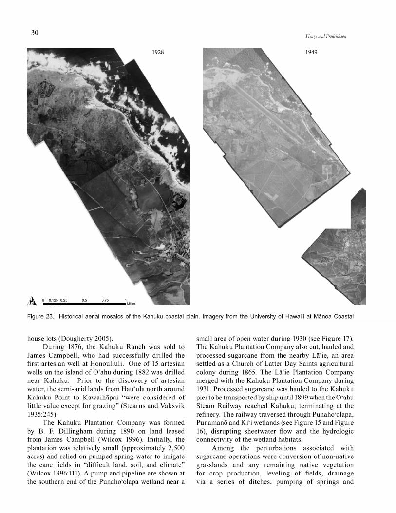
30 Henry and Fredrickson
1928 1949
O 0 0.25 0.5 0.75 10.125Miles
Figure 23. Historical aerial mosaics of the Kahuku coastal plain. Imagery from the University of Hawai‘i at Mānoa Coastal
house lots (Dougherty 2005). During 1876, the Kahuku Ranch was sold to
James Campbell, who had successfully drilled the first artesian well at Honouliuli. One of 15 artesian wells on the island of O‘ahu during 1882 was drilled near Kahuku. Prior to the discovery of artesian water, the semi-arid lands from Hau‘ula north around Kahuku Point to Kawaihāpai “were considered of little value except for grazing” (Stearns and Vaksvik 1935:245).
The Kahuku Plantation Company was formed by B. F. Dillingham during 1890 on land leased from James Campbell (Wilcox 1996). Initially, the plantation was relatively small (approximately 2,500 acres) and relied on pumped spring water to irrigate the cane fields in “difficult land, soil, and climate” (Wilcox 1996:111). A pump and pipeline are shown at the southern end of the Punaho‘olapa wetland near a
small area of open water during 1930 (see Figure 17). The Kahuku Plantation Company also cut, hauled and processed sugarcane from the nearby Lā‘ie, an area settled as a Church of Latter Day Saints agricultural colony during 1865. The Lā‘ie Plantation Company merged with the Kahuku Plantation Company during 1931. Processed sugarcane was hauled to the Kahuku pier to be transported by ship until 1899 when the O‘ahu Steam Railway reached Kahuku, terminating at the refinery. The railway traversed through Punaho‘olapa, Punamanō and Ki‘i wetlands (see Figure 15 and Figure 16), disrupting sheetwater flow and the hydrologic connectivity of the wetland habitats.
Among the perturbations associated with sugarcane operations were conversion of non-native grasslands and any remaining native vegetation for crop production, leveling of fields, drainage via a series of ditches, pumping of springs and

31HGM EVALUATION OF ECOSYSTEM RESTORATION FOR JAMES CAMPBELL NWR
1971 2006
Geology Group (http://www.soest.hawaii.edu/coasts/data/).
groundwater, and disposal of waste water after processing. Thus, the activities associated with the sugarcane operation had a profound effect upon the topography and wetland processes in the area surrounding the Ki‘i, Punamanō, and Punaho‘olapa wetland areas. Lands were developed for sugarcane production across the low lying area and within some of the flatter topography along the coastal zone where agricultural practices reached the coral outcroppings. The maximum extent of agricultural lands for sugarcane production can likely be inferred from aerial photos taken during 1971 (Figure 23).
Growing and processing sugarcane requires a large amount of water. Four thousand pounds (500 gallons) of water is needed to produce 1 pound of sugar (Wilcox 1996). Irregular rainfall on the Kahuku plain reduced crops’ yields, and in some years caused crops to fail completely. Pumped spring
water, irregular rainfall, and flashy intermittent streams proved inadequate for irrigation and artesian wells were drilled. Eight wells were drilled during 1900 approximately 1 mile northwest of the Kahuku Store (Stearns and Vaksvik 1935, Stearns and Vaksvik 1938). Well drilling continued and by 1930, 34 wells were drilled by the Kahuku Plantation Company at Kahuku and Lā‘ie. Pumping from wells yielded 20 Mgal/d (Table 6) and combined pumping and artesian flow was estimated at 27 Mgal/d during 1932 (Stearns and Vaksvik 1935). Artesian flows from wells on the Kahuku Plantation ranged from 400 to 1,500 gpm. By 1938, a total of 44 wells were drilled from Kawelo Bay to Kahuku; additional wells were located south of Kahuku, including 24 artesian wells in Lā‘ie and Kaikapau (Stearns and Vaksvik 1938). Groundwater levels declined 1 ft by 1923 and then remained relatively stable through

32 Henry and Fredrickson
YearNumber of
Wellsa
Annual Total Pumped
(millions of gallons)
Average Daily Pumped (mgd)
1926 7 5,245 14.371927 7 2,832 7.761928 7 4,053 11.071929 5 4,608 12.621930 11 4,723 12.941931 14 6,278 17.21932 15 6,162 16.841933 15 7,699 21.09
a Includes four wells at Lā‘ie with no records available before September 1931.
Table 6. Water pumped from wells by Kahuku PlantationCompany during 1926-1933. Data compiled from Stearns andVaksvik (1935).
the mid 1930s; chloride content of all wells was less than 100 mg/l (0.18 ppt) when initially drilled (Stearns and Vaksvik 1938). Drilled well locations are shown in Figure 24.
Ditches were dug through the coral outcrops and sand dunes so that water could be transported to the ocean in a more direct way. Two drainage ditches were dug from Punaho‘olapa. Water from one drainage ditch was pumped to supply water for the irrigation of cane fields and a second drainage ditch drained water from the wetland to the ocean. At Punamanō, a ditch was dug to convey water from the west spring. Ki‘i was used as a settling basin for the water from sugarcane processing. This waste water from the Kahuku sugar mill was stored in Ki‘i before being used for irrigation or pumped to the ocean. A concrete control structure directed the water at Ki‘i to irrigate sugarcane fields or to a pump for disposal to the ocean through the Ki‘i Outlet ditch. Water collected in the Hospital and Punamanō ditches was also brought to the Ki‘i Outlet Ditch within the Ki‘i unit of the refuge. Aerial imagery from 1928 shows Ki‘i as a large open water area, but except for the railroad bed, no dikes crossed or surrounded the area (Figure 23). At least some dikes were built between 1928 and 1949 when dikes are visible around and through the northeast portion of Ki‘i. The full extent of Ki‘i is not shown in aerial photos again until 1971 (Figure 23), when the configuration of the Ki‘i area is similar to current conditions. Heavy silt loads in the waste water made it necessary to periodically increase the height of the dikes at Ki‘i (U.S. Bureau
of Sport Fisheries and Wildlife 1971). By the 1960s, yields from wells in the
basal aquifer on the Kahuku coastal plain were as high as 50 Mgal/d during periods of heavy irrigation and averaged 22 Mgal/d (Takasaki and Valenciano 1969). On average an additional 4 Mgal/d was pumped from the sedimentary aquifer and used for irrigation and washing of sugarcane (Takasaki and Valenciano 1969). Groundwater levels that had previously remained relatively stable through the mid 1930s decreased by 2 ft from 1930 to 1963 (Stearns and Vaksvik 1938, Takasaki and Valenciano 1969).
The chloride content of some wells on the Kahuku coastal plain rose to 1,600 mg/l (3 ppt) because pumping from the basal aquifer exceeded the natural groundwater recharge by approximately 10 Mgal/d (Takasaki and Valenciano 1969). Groundwater pumping from the freshwater basal aquifer decreased
the freshwater head and therefore resulted in the inland and upward movement of the underlying sea water referred to as salt water intrusion. Brackish water from several wells (salinity greater than 0.6 ppt) was used to irrigate some sugarcane fields on the Kahuku coastal plain in what is now JCNWR. Irrigation of sugarcane fields with brackish water and the associated evapotranspiration increased the salt content of the water and leached salts from fertilizers. Infiltration of irrigated water into the basal aquifer generally does not significantly affect water quality because the inputs are small compared to other inputs and vertical dispersion within the aquifer is limited. Nevertheless, increased levels of chloride and nitrate were detected in the upper basal aquifer on the Kahuku coastal plain during 1964 (Takasaki and Valenciano 1969).
During the late 1960s, the Kahuku Plantation Company used 11 wells, 3 batteries of wells and 23 pumps to irrigate 4,400 acres (U.S. Bureau of Sport Fisheries and Wildlife 1971). Specific withdrawal rates and management of water for sugarcane after 1933 is not well documented, but pumps and wells of interest for management of the proposed “Kahuku National Wildlife Refuge” were described by the U.S. Bureau of Sport Fisheries and Wildlife (1971).
• Pump A drew approximately 3.1 cfs of ground-water and 6.2 cfs of surface water through a drain from Punaho‘olapa Pond to irrigate 9 sugarcane fields. When the pump is not operating water in the drainage ditch rises 3

33HGM EVALUATION OF ECOSYSTEM RESTORATION FOR JAMES CAMPBELL NWR
Figure 24. Location of wells drilled on the Kahuku coastal plain in relation to geologic features (from Takasaki and valenciano 1969:8).
to 4 feet, indicating that if the drainage ditch was plugged, increased water would remain in Punaho‘olapa.
• Pump B lifted water to irrigate a small sugarcane field between Punaho‘olapa and Punamanō wetlands. It was located on the drain from Punamanō to its discharge above the pump lifting water to the ocean from the Ki‘i settling pond operations.
• Pump C lifts the drain water and surplus water from the Ki‘i settling pond operations.
• Wells drilled at the sugar mill have a capacity of 7 cfs and water is pumped to a reservoir on the 240 foot contour to irrigate 4 sugar cane fields.
• The coral well, an additional well at the sugar mill dug 15 feet deep provides 7 cfs of water for cane washing. Surplus water is combined with other well water to reduce salinity and used for irri-gation of a sugarcane field west of the mill.
• Discharge from Ki‘i settling basins was estimated at 12 cfs during November 1970.
Perturbations to the area nearer the coast were dramatically increased during World War II when the military constructed an airstrip along with the supporting infrastructure required for military operations. Construction of the Kahuku Army Air Base, started during December 1941 with a NE-SW runway at Kahuku Point. Poor drainage of the area hampered construction and the runway was relocated three times before a suitable location was found (Bennett 2011). During construction canals, underground drain pipes, and culverts were installed to keep the runway from flooding. A second NW-SE runway was built along the eastern portion of the Kahuku coastal plain after 1942 and the first runway was widened during 1943 to accommodate large
bombers. The runways were covered with pierced steel planking and eventually paved with asphaltic concrete. The runways were 200 feet wide with a 100 ft coral shoulder on each side.
Other supporting infrastructure was built including about 32 earthen revetments, a control tower, barracks, officer’s quarters, mess halls, a chapel, dispensaries, and two fire stations. Roads, a water distribution system, and sewer system were also built (Bennett 2011). A radio transmitter was built near Kahuku Point by 1930 (see Figure 17) and a tunneled radio station, 1,130 ft long by 29 ft wide and 65 to 95 ft below the surface was built during WWII (Bennett 2011).
Comparing U.S. Army Corps of Engineer

34 Henry and Fredrickson
maps from 1929-30 and the 1940s, the small wetland areas north of Punaho‘olapa and one wetland area northeast of Punamanō were filled or drained during the construction of the runways at the Kahuku Army Air Base. Extensive areas of coastal sand dunes and coral outcrops were leveled for the runways. Infrastructure for the military base further altered the natural topography of the coastal strand area and encroached on the inland alluvium areas, obliterating 3 of the 4 wetland areas between Punamanō and Ki‘i. The invasive species intermixed with native vegetation within this coastal zone suggests heavy equipment movements caused disruptions where non-native vegetation became established.
The 1946 tsunami caused extensive damage to the Kahuku Army Air Base. Buildings were smashed, parking areas were uprooted, and sand and debris washed onto the runways. Following the tsunami, flight operations ceased and the land was returned to the James Campbell Estate between 1947 and 1948 (Bennett 2011). Radar continued to be operated at Punamanō Hill until 1948.
By the 1960s, the thriving sugar cane industry started to decline. Operations finally ceased in 1971 when the refinery closed. As the acreage in sugarcane declined, the demand for water also declined. Estimated groundwater recharge for windward O‘ahu during the mid 1980s was similar to predevelopment conditions (Shade and Nichols 1996). Chloride levels in wells that had reached 1,600 mg/l during the late 1950s declined to approximately 1,100 mg/l by 1964 (Takasaki and Valenciano 1969). Chloride levels of the groundwater continued to decline as pumping rates declined. For example, the conductivity of water from the Ki‘i artesian wells was 650 uS/cm (approximately 0.2 ppt) during November 1997 (Hunt and De Carlo 2000). Salinity levels of water in the ditches have also decreased since the decline of sugarcane production and were substantially less during 1997 compared to the 1960s (Hunt and De Carlo 2000).
In a 1974 letter to the U. S. Fish and Wildlife Service, the Estate of James Campbell states that the “Kii [sic] area has dried up almost completely due to minimal irrigation, discontinuance of drainage pumping and mill cane-washing operations” and that Punamanō was constantly under water and has expanded in size. Punamanō likely increased in size due to the reduced groundwater pumping, which may have increased the amount of water that naturally discharged through Punamanō and other springs. Sedimentation from sugarcane settling basins and the repeated raising of dikes at Ki‘i had effectively filled
the historical wetland. The dormant agricultural fields and refinery lands were quickly dominated by invasive species, including California grass (Urochloa mutica), California bulrush (Schoenoplectus californicus), marsh fleabanes (Pluchea spp.), and knotgrass (Paspalum spp.).
As a means to generate local employment following the decline of sugarcane agriculture and the closure of the Kahuku sugar mill, local and county officials supported diversified agricultural development. A 15 acre saltwater aquaculture facility was constructed mid-way along Ki‘i ditch during 1979. By 1984, additional aquaculture farms and truck crop farms were established along Kamehameha Highway near Ki‘i and northeast of Punamanō. Truck crops and orchards were established on some areas inland of Kamehameha Highway. Construction of aquaculture ponds dramatically modified the local topography, inter-mixed soils with varying characteristics, and disrupted ground water movements. Furthermore, aquaculture ponds managed for salt water species also changed salinities of the soil and surface water. For example, salinity in Pond E at Ki‘i was as high as 22 to 26 ppt when effluent from the saltwater aquaculture facility was discharged to the ditches. Nevertheless, these aquaculture ponds attracted endangered and migrant waterbirds as soon as operations began in the late 1970s because open water was available in contrast to the dry and overgrown condition at Ki‘i and the dense, non-native wetland areas of Punamanō.
A secondary waste water treat ment plant was built south of Ki‘i during the late 1970s. A hotel, cottages, cabanas, homes and a golf course, now known as Turtle Bay Resort, were built at Kuilima Estates during the 1970s. The Turtle Bay Resort has almost obliterated all traces of the original NE-SW runway (Bennett 2011), filled in a significant portion of the historical Punaho‘olapa wetland area, and created open water pond areas. The extent of wetland habitats during 2005 based on the USFWS National Wetland Inventory is shown in Figure 25. During 2011, 12 wind turbines with the capacity to produce 30 megawatts of power were constructed west of JCNWR.
Ditches originally constructed for the growing and processing of sugarcane (e.g., Ki‘i and Outlet ditches) are now considered important components of the flood control infrastructure for the town of Kahuku. Construction of Kamehameha Highway, fill associated with construction and agriculture in the 100-year floodplain, and drainage ditches have 1) reduced the capacity of the lower ‘Ō‘io watershed to
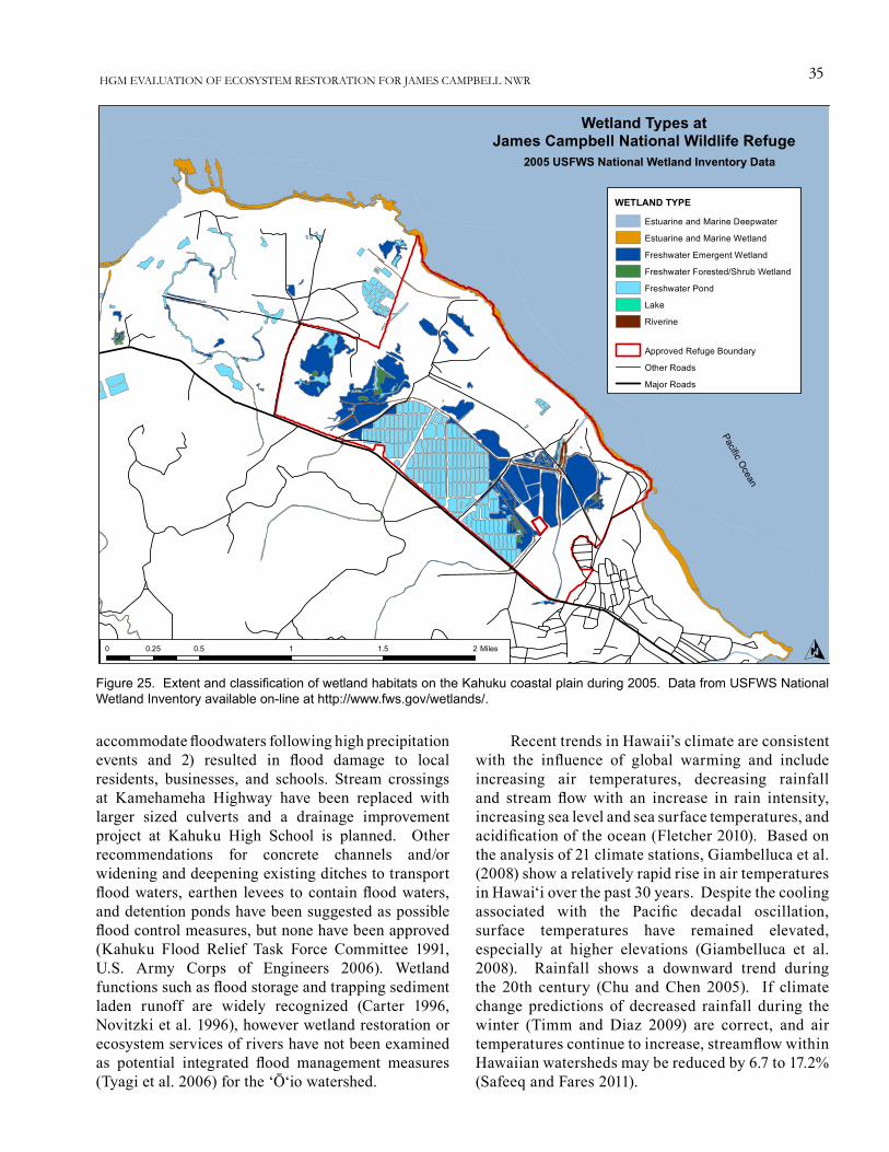
35HGM EVALUATION OF ECOSYSTEM RESTORATION FOR JAMES CAMPBELL NWR
Wetland Types atJames Campbell National Wildlife Refuge
2005 USFWS National Wetland Inventory Data
O0 0.5 1 1.5 20.25 Miles
Pacific Ocean
Estuarine and Marine Deepwater
Estuarine and Marine Wetland
Freshwater Emergent Wetland
Freshwater Forested/Shrub Wetland
Freshwater Pond
Lake
Riverine
Approved Refuge Boundary
Other Roads
Major Roads
WETLAND TYPE
Figure 25. Extent and classification of wetland habitats on the Kahuku coastal plain during 2005. Data from USFWS National Wetland inventory available on-line at http://www.fws.gov/wetlands/.
accommodate floodwaters following high precipitation events and 2) resulted in flood damage to local residents, businesses, and schools. Stream crossings at Kamehameha Highway have been replaced with larger sized culverts and a drainage improvement project at Kahuku High School is planned. Other recommendations for concrete channels and/or widening and deepening existing ditches to transport flood waters, earthen levees to contain flood waters, and detention ponds have been suggested as possible flood control measures, but none have been approved (Kahuku Flood Relief Task Force Committee 1991, U.S. Army Corps of Engineers 2006). Wetland functions such as flood storage and trapping sediment laden runoff are widely recognized (Carter 1996, Novitzki et al. 1996), however wetland restoration or ecosystem services of rivers have not been examined as potential integrated flood management measures (Tyagi et al. 2006) for the ‘Ō‘io watershed.
Recent trends in Hawaii’s climate are consistent with the influence of global warming and include increasing air temperatures, decreasing rainfall and stream flow with an increase in rain intensity, increasing sea level and sea surface temperatures, and acidification of the ocean (Fletcher 2010). Based on the analysis of 21 climate stations, Giambelluca et al. (2008) show a relatively rapid rise in air temperatures in Hawai‘i over the past 30 years. Despite the cooling associated with the Pacific decadal oscillation, surface temperatures have remained elevated, especially at higher elevations (Giambelluca et al. 2008). Rainfall shows a downward trend during the 20th century (Chu and Chen 2005). If climate change predictions of decreased rainfall during the winter (Timm and Diaz 2009) are correct, and air temperatures continue to increase, streamflow within Hawaiian watersheds may be reduced by 6.7 to 17.2% (Safeeq and Fares 2011).

36 Henry and Fredrickson
Figure 26. Monthly mean sea level at Honolulu, Hawai‘i (station 1612340) from 1911 to 2011. data from NOAA (2012).
Based on data from the NOAA tide station at Honolulu, Hawai‘i (Figure 26), sea level has risen 1.5 ± 0.25 mm/yr over the past century (Fletcher et al. 2012). Ocean surface pH exhibits substantial seasonal and interannual variability, but has significantly decreased over the past 20 years at a rate expected from chemical equilibrium with the atmosphere (Dore et al. 2009). In addition, sea surface temperature, measured 62 miles north of Kahuku Point, has increased 0.22oF per decade (Fletcher 2010).
Changes in marsh area and habitat type in response to predicted sea-level rise at JCNWR were modeled using the Sea Level Affecting Marshes Model (SLAMM 6) (Clough and Larson 2010). The historical trend for sea level rise was estimated at 1.31 mm/yr using the nearest NOAA gage at Mokuolo‘e. This rate is similar to the global average for the last 100 years (approximately 1.7 mm/year). Under different scenarios of sea level rise, the SLAMM simulation of JCNWR predicts non-diked areas to be vulnerable to the effects of sea level rise. Between 4% and 54% of refuge undeveloped dry land is predicted to be flooded across all sea level rise scenarios. Between 5% and 62% of the refuge inland fresh marsh – which makes up around 20% of the refuge – is predicted to be lost across all sea level rise scenarios.
During 2012, more detailed modeling of sea level rise impacts using LiDAR with additional post-processing to improve elevational data was initiated. Preliminary results indicate that 25-50% of the refuge will be below sea level by 2100, with the rate
of surface water inundation increasing around 2060 (C. Fletcher, University of Hawai‘i, unpublished data). Modeling of sea level rise and climate change impacts on groundwater resources worldwide is limited and results are highly variable due to the complex nature of aquifers (Green et al. 2011). No sea level rise impacts have been modeled for confined aquifers in Hawai‘i. If rainfall continues to decline, then recharge to freshwater basal aquifers will likely decline, elevating the brackish water transition zone (Wallsgrove and Penn 2012). A model of predicted impacts of sea level rise on an unconfined aquifer in the Pearl Harbor area shows a strong connection between sea level and water table level in the unconfined aquifer. Therefore, sea level rise will likely result in indirect (e.g., rise in water
table level) and direct (e.g., connected to ocean by ditch) surface inundation (C. Fletcher, University of Hawai‘i, personal communication).
Morphologic changes in Hawaii’s shoreline result from seasonal variability of the wave cycle, extreme events (e.g., tsunamis), and long-term sea level changes and sediment budgets.
Long-term shoreline change rates during the past century in the vicinity of JCNWR are erosional to stable and range from -0.04 ± 0.08 m/yr to -0.20 ± 0.26 m/yr (Figure 27) (Romine et al. 2012). These relatively low erosion rates are a result of the limestone shelf that stabilizes the position of the shoreline (Fletcher et al. 2010). Kahuku beach to the south of JCNWR had significant erosion at -1.2 ± 0.6 m/yr as a result of sand mining, while Lā‘ie, further south had accretion rates of up to 0.4 ± 0.2 m/yr (Fletcher et al. 2012).
CHANGES iN PLANT ANd ANiMAL POPULATiONS
No population change estimates are available for native Hawaiian plants at JCNWR; available data are limited to occurrence and distribution information. Of 126 native plants known from coastal O‘ahu, only 54 species were observed during recent surveys of the island (Warshauer et al. 2006). Thirty two species of native plants and 65 species of non-native plants are known from JCNWR (USFWS 2011a) (Appendix A). Vegetation surveys from six sites on the Kahuku

37HGM EVALUATION OF ECOSYSTEM RESTORATION FOR JAMES CAMPBELL NWR
1 2
3
98
5
6
4
11
14
24
12
15
10
17 1819 20
21 22
Shoreline Change Analysis in the vicinity ofJames Campbell National Wildlife Refuge
Spatial and Tabular Data from Romine et al. (2012)
O0 0.2 0.4 0.6 0.80.1 Miles
0 0.25 0.5 0.75 10.125 Kilometers
13
1 -0.05 0.05 2 -0.05 0.05 3 -0.06 0.06 4 -0.06 0.06 5 -0.10 0.08 6 -0.04 0.08 7 -0.08 0.08 8 -0.10 0.09 9 -0.11 0.08 10 -0.10 0.11 11 -0.14 0.15 12 -0.11 0.04 13 -0.12 0.03 14 -0.12 0.16 15 -0.11 0.15 16 -0.10 0.25 17 -0.12 0.26 18 -0.13 0.30 19 -0.14 0.32 20 -0.20 0.26 21 -0.13 0.22 22 -0.10 0.14 23 -0.09 0.18 24 -0.07 0.16
Transect Rate (m/yr) 95%CI
Long-term Shoreline Change(negative values indicate erosion)
Figure 27. Shoreline change analysis in the vicinity of James Campbell National Wildlife Refuge indicates low rates of shoreline erosion during the past century. Spatial and tabular data from Romine et al. (2012).
coastal plain recorded 16 species of native plants and four species of Polynesian introductions (Warshauer et al. 2006). An additional three species that were historically recorded from the Kahuku coastal plain (Gossypium tomentosum, Lepidium bidentatum o-waihiensis, and Melanthera integrifolia) have not been observed during recent surveys. An additional six species have been recorded at the nearby offshore islet Moku‘auai, but not on the coastal plain (Warshauer et al. 2006). These species recorded from Moku‘auai
may have been locally extirpated from the coastal plain prior to Western contact and/or documentation. Two species of coastal plants previously recorded from the Kahuku plain (Cyperus polystachos and C. laevigatus) have been extirpated from O‘ahu (Warshauer et al. 2006). Native wetland plants at JCNWR include several species of native sedges, ‘akulikuli (Sesuvium portulacastrum), and ‘ae‘ae (Bacopa monneri).
At least 5 species of non-native trees that have been identified as one of the biggest threats

38 Henry and Fredrickson
Figure 28. All available waterbird survey data for three species of endangered waterbirds at James Campbell National Wildlife Refuge during 1989-2008 (USFWS unpublished data). Surveys generally were conducted monthly; how-ever, the number of available surveys varied among years because multiple sur-veys were completed during some months.
to native coastal vegetation (Warshauer et al. 2006) occur at JCNWR. These include ironwood (Causarina equisetifolia), kiawe (Prosopsis pallid), false kamani (Terminalia catappa), Christmas berry (Schinus terebinthifolius), and haole koa (Leucaena leucocephala). Other threats to native coastal vegetation include non-native shrubs and forbs that displace native vegetation, rats that eat seeds, ants that have symbiotic relationships with plant pest species, and domestic livestock that browse on leaves and new shoots.
Historical and relatively recent grazing of sand dune and other coastal strand habitats likely altered the composition and relative abundance of native vegetation communities along the coastline. Shifts in native plant communities from grass-dominated to shrub-dominated as a result of domestic livestock grazing have occurred in other semi-arid environments (Christensen and Johnson 1964) and likely occurred within remnant native habitats along the Kahuku coastline. Preferential grazing of grasses and forbs by some domestic livestock and loss of the historical hala tree overstory may have altered successional pathways, resulting in an increase of some shrub species within the coastal zone. In addition, the presence of domestic livestock may alter the competitively ability of native plant to resist alien displacement (Merlin and Juvik 1992), reducing
native biodiversity. Koa haole and kiawe often dominate coastal shrublands that have been grazed (Wagner et al. 1999). Increases in native or non-native shrub density may negatively impact ground nesting seabirds.
Grazing by domestic livestock and human disturbances may also increase compaction, altering substrate characteristics which may detrimental to the germination and growth of some native species. For example, Bermuda grass (Cynodon dactylon) is dominant on areas of compacted soil, whereas native species such as ‘aki‘aki occur on areas of loose sand. Pohuehue is another species that may be locally dominant in areas disturbed by humans or domestic livestock (Wagner et al. 1999).
Three species of endemic waterbirds (ae‘o, ‘alae ke‘oke‘o, and ‘alae ‘ula), koloa maoli-mallard hybrids, and one species of indigenous
(‘auku‘u) waterbird occur at JCNWR. Early accounts suggests that koloa-maoli, ae‘o, ‘alae ke‘oke‘o, and ‘alae ‘ula were common during the mid- to late 1800s and that populations rapidly declined during the early 1900s. Population estimates of ae‘o, ‘alae ke‘oke‘o, and ‘alae ‘ula from the 1950s were less than 1,000 individuals of each species resulting in their listing as an endangered species (USFWS 2011b). The koloa maoli was also listed as an endangered species. The koloa maoli was believed to be extirpated from the island of O‘ahu by the early 1960s (Shallenberger 1977). From 1968 to 1982, 326 koloa maoli were released on the island of O‘ahu at wetlands near Kailua, Kāne‘ohe, and Waimea (Engilis and Pratt 1993, USFWS 2011b). The native koloa maoli hybridized with feral mallards that had escaped from duck farms in Kahuku region during the 1930s and 1940s and genetic evidence suggests that most, if not all, of the koloa maoli on O‘ahu are hybrids. Biannual waterbird surveys indicate that the number of koloa maoli is decreasing while the number of mallard-koloa maoli hybrids is increasing (USFWS 2011b).
The Ki‘i Unit at JCNWR has one of the largest concentrations of ‘alae ke‘oke‘o on the island of O‘ahu (USFWS 2011b) and population data from 1989 to 2008 suggest that the population is increasing (Figure 28) (USFWS unpublished data). The population of ‘alae ‘ula at JCNWR during the same time period

39HGM EVALUATION OF ECOSYSTEM RESTORATION FOR JAMES CAMPBELL NWR
Figure 29. Average counts ± 95% confidence intervals for three species of endemic waterbirds (HACO=Hawaiian coot, HAMO=Hawaiian moorhen, and HAST=Hawaiian stilt) during three different management periods at James Campbell National Wildlife Refuge. Management periods are as fol-lows: Group 1 = 1989–1995; Group 2 = 1996–June 2005; and Group 3 = July 2005–September 2008. From USFWS (unpublished data).
appear to be slightly increasing while ae‘o appear to be relatively stable. Endangered waterbirds also appear to have responded to management actions.Waterbird survey counts show that ‘alae ke‘oke‘o increased after 1995, likely in response to increased management actions (Figure 29). Compared to 1989-1995 survey results, all three species of endangered waterbirds have increased during 2005-2008 when a significant expansion of usable habitat occurred on the refuge (Figure 29) (USFWS unpublished data). No population or trend estimates are available for other animals, including honu, ‘īlioholoikauaua, seabirds, or aquatic invertebrates.
ESTABLiSHMENT ANdMANAGEMENT OF JCNWR
In the years before the U.S. Fish and Wildlife Service began to acquire lands in the Hawaiian Islands, sugarcane refinery settling basins provided more open conditions for wetland dependent birds including the endemic Hawaiian waterbirds. The focus on the Kahuku area was tied to the condition of the Ki‘i area where the sugarcane settling basins from the Kahuku sugar mill provided flooded open-water habitat where waterbirds concentrated in the highly disrupted coastal zones in Hawai‘i. The settling ponds were not designed to optimize wetland functions and processes, thus from the beginning, management of this highly disrupted site has been complex and challenging. The Ki‘i site was identified as a place where waterbirds occurred regularly before acquisition. Punamanō and Punaho‘olapa wetlands were also identified as important wetland habitats used by endemic Hawaiian waterbirds, but the area of Punaho‘olapa was identified for development by the Estate of James Campbell. JCNWR was established at Ki‘i and Punamanō in 1976 through a long-term lease to 1) “preserve habitat vital to the rare and endangered species ae‘o (Hawaiian stilt) [and] ‘alae ke‘oke‘o (Hawaiian coot)” and 2) “provide habitat for other shorebirds and waterfowl on the island of O‘ahu” (USFWS 2011a:I-5).
The James Campbell National Wildlife Expansion Act of 2005 (Public Law 109-225; 16 USC 668dd) expanded the boundary of the refuge to include approximately 1,100 acres for the purposes of 1) permanently protecting endangered species habitat, 2) improving the management of the refuge, and 3) promoting biological diversity for threatened and endangered species including endangered Hawaiian
waterbirds, migratory shorebirds and waterfowl, breeding seabirds, endangered and native plant species, endangered monk seals, and breeding green sea turtles. Originally encompassing approximately 150 acres of land leased from the Estate of James

40 Henry and Fredrickson
Year Wetland Development and Management Activities
1977 James Campbell NWR, consisting of the Ki‘i and Punamanō, established for endangered waterbird species.
Wetland habitat management capabilities limited to 20 acres at Ki‘i.
Nesting islands constructed in the 20 acre impoundment.
Flowage easement at Ki‘i ditch acquired which connected Punamanō to Ki‘i.
1980-81 Effluent from saltwater shrimp farm dumped into Ki‘i ditch and salinities at Ki‘i rose from 5 ppt to 15-18 ppt so an injection well was installed to dispose of effluent.
Hog and barbed wire fencing constructed around 90% of Ki‘i.
Leveled and lowered B Pond by 1-foot; used excess dirt to raise the main roadway in the center of the unit.
Nesting islands constructed in Ponds B and C, and dense grass removed from southern quarter of Pond C.
Culverts and water control structures installed.
New pump structure with a 40 horsepower flood control pump and a 5 horsepower pump to supply water to Ponds B, C, and D was installed at Ki‘i.
Wetland development actions tripled wetland habitat.
1982 Prescribed burn in Ponds C and F and the drainage ditch.
Dredged Ki‘i ditch between the Kahuku Airstrip road and the Ki‘i Unit along the west side of Pond E to the outlet.
During high tides saline water moves into Pond E and the lower drainage ditches.
Pond A drained and 40% of Batis maritima sprayed with herbicide.
No management at Punamanō.
1983 Maintain water levels in Ponds A, B, C, & D by pumping water from drainage canals.
Ponds C and F excavated to a depth of 3.5 ft amsl; excess materials used to "shore up" dikes around Ponds C, D, F, & G.
Five new water control structures with metal culvert flashboard risers installed.
1984 Installed 14 ft windmill and additional fiberglass pump.
Water pumped into Ponds G and F for the first time.
1986 Drawdowns on Ponds B, C, and F created stilt nesting habitat.
Manipulated water levels in Ponds A, B, C, D, F, and G by pumping water from drainage canals with 5 hp electric pump and 2 low-lift pumps from windmills.
Running the 40 hp pump would flish the sand plug in the ditch and allow pond drainage.
Smaller nesting islands constructed in Ponds B, C, and F.
1987 Installed freshwater wells, pump, and 1,600 ft of 12-inch PVC water delivery system. Water deliver pipe directly connected to Ponds B, C, F, and G and indirectly to Ponds A and D.
1988 Proposal for fee acquisition of the refuge developed for wetland areas and buffers and included existing leased refuge units.
Table 7. Chronology of wetland developments on James Campbell National Wildlife Refuge. Data compiled fromunpublished USFWS annual narratives and reports.

41HGM EVALUATION OF ECOSYSTEM RESTORATION FOR JAMES CAMPBELL NWR
Year Wetland Development and Management Activities
1977 James Campbell NWR, consisting of the Ki‘i and Punamanō, established for endangered waterbird species.
Wetland habitat management capabilities limited to 20 acres at Ki‘i.
Nesting islands constructed in the 20 acre impoundment.
Flowage easement at Ki‘i ditch acquired which connected Punamanō to Ki‘i.
1980-81 Effluent from saltwater shrimp farm dumped into Ki‘i ditch and salinities at Ki‘i rose from 5 ppt to 15-18 ppt so an injection well was installed to dispose of effluent.
Hog and barbed wire fencing constructed around 90% of Ki‘i.
Leveled and lowered B Pond by 1-foot; used excess dirt to raise the main roadway in the center of the unit.
Nesting islands constructed in Ponds B and C, and dense grass removed from southern quarter of Pond C.
Culverts and water control structures installed.
New pump structure with a 40 horsepower flood control pump and a 5 horsepower pump to supply water to Ponds B, C, and D was installed at Ki‘i.
Wetland development actions tripled wetland habitat.
1982 Prescribed burn in Ponds C and F and the drainage ditch.
Dredged Ki‘i ditch between the Kahuku Airstrip road and the Ki‘i Unit along the west side of Pond E to the outlet.
During high tides saline water moves into Pond E and the lower drainage ditches.
Pond A drained and 40% of Batis maritima sprayed with herbicide.
No management at Punamanō.
1983 Maintain water levels in Ponds A, B, C, & D by pumping water from drainage canals.
Ponds C and F excavated to a depth of 3.5 ft amsl; excess materials used to "shore up" dikes around Ponds C, D, F, & G.
Five new water control structures with metal culvert flashboard risers installed.
1984 Installed 14 ft windmill and additional fiberglass pump.
Water pumped into Ponds G and F for the first time.
1986 Drawdowns on Ponds B, C, and F created stilt nesting habitat.
Manipulated water levels in Ponds A, B, C, D, F, and G by pumping water from drainage canals with 5 hp electric pump and 2 low-lift pumps from windmills.
Running the 40 hp pump would flish the sand plug in the ditch and allow pond drainage.
Smaller nesting islands constructed in Ponds B, C, and F.
1987 Installed freshwater wells, pump, and 1,600 ft of 12-inch PVC water delivery system. Water deliver pipe directly connected to Ponds B, C, F, and G and indirectly to Ponds A and D.
1988 Proposal for fee acquisition of the refuge developed for wetland areas and buffers and included existing leased refuge units.
Table 7. Chronology of wetland developments on James Campbell National Wildlife Refuge. Data compiled fromunpublished USFWS annual narratives and reports.
Table 7. Chronology of wetland developments on James Campbell National Wildlife Refuge. Data compiled fromunpublished USFWS annual narratives and reports.
Groundwater used for water management has better water quality than previously used water from the drainage ditches.
Drawdowns on Ponds B, C, F, and G created stilt nesting habitat.
Blooms of filamentous green algae occurred in Ponds C and F.
Additional small nesting islands constructed.
Flapgate installed at Punamanō to reduce saltwater inflow from Amorient shrimp farm.
Moats still present in the impoundments.
1989 Pond B treated with herbicide, burned, and then flooded for 6 weeks to kill sprouted plants.
1995 Habitat management for endangered Hawaiian waterbirds increased.
2002 New pumphouse at Ki‘i
2007 Invasive California bulrush removed from 21 acres at Punamanō and 10 acres in Pond G at Ki‘i.
Non-native brush and shrubs removed near Pumamanō to restore uplands and temporary wetlands for migratory shorebirds.
Non-native vegetation removed from Pond B at Ki‘i
Dike between Ponds D and G was repaired.
Water control structure installed in Pond F at Ki‘i.
2010 USFWS acquired fee title to 934 acres, including the Ki‘i and Punamanō Units.
Table 7., cont’d.
Campbell, this refuge currently contains 934 acres in fee title. An additional 151 acres are part of an acquisition plan in which negotiations are underway for purchase. Once this remaining area is acquired, the 1,085 acres approved for acquisition will be complete.
Although initially established for the purpose to conserve endangered waterbird species, the management direction of JCNWR has become more holistic. The 2011 Comprehensive Conservation Plan for the refuge identified specific goals for endangered waterbird recovery, acquisition, management and restoration of native habitats, collection of scientific data, public use and education, historic and cultural resources, and cooperative planning to reduce flood damage (USFWS 2011a).
Following establishment of the refuge, wetland development activities began on the refuge and
have continued to the present (Table 7). None of these developments were based on an analysis of geomorphic and hydrologic conditions. Initially, water levels at Ki‘i were managed by pumping water from the Punamanō ditch into a 20-acre impoundment.
At the time of early wetland management operations in Hawai‘i, predation was a major concern and there was a poor understanding of the factors that created and maintained productive tropical wetland conditions to provide the required structure and foods for endemic waterbirds. It was a time on the mainland when the benefits of large isolated islands were identified for waterfowl nesting. The practice of building islands as an effective management tool was promoted and the practice became widespread on the mainland and in Hawai‘i. Moats and islands were typically incorporated into infrastructure

42 Henry and Fredrickson
Figure 30. Flow map for water at James Campbell National Wildlife Refuge. From USFWS draft WRiA, unpublished.
development in an effort to control predation and to provide secure nesting sites. This was the case on the Ki‘i unit where moats and islands were part of the initial infrastructure development.
The use of moats was thought to be a good strategy to restrict terrestrial predator access to nesting wetland dependent birds because there was a deep water barrier. The concept was ineffective because early refuge staff had little knowledge about the ecology of invasive species such as California grass that grew rapidly forming a mat of vegetation that easily provided enough support for predators to cross deeply flooded areas. However, the most detrimental aspect of moats was that complete drainage of units was compromised. Drawdowns were essential for the management purposes aimed at creating suitable conditions for germination of wetland
vegetation. Furthermore, the wet area along the edge of the impoundments compromised the movement of equipment into the impoundments that was necessary to create bare mineral soil where desirable vegetation for waterbirds would germinate.
Substantial developments occurred during the early 1980s when ponds B, C, D, F, and G were rehabilitated, but the rehabilitation occurred without changing the location of levees forming these five units (Figure 30). The rehabilitation of the wetland impoundments included excavating deeper basins, repairing and raising dikes, installing new water control structures and pumps, and creating nesting islands. None of these changes recognized soil texture or salinity levels. There was a lack of understanding about how to construct islands that would match the ecology of the species present, as well as their effects

43HGM EVALUATION OF ECOSYSTEM RESTORATION FOR JAMES CAMPBELL NWR
Figure 31. Annual groundwater use for management of Ki‘i wetland impoundments at James Campbell National Wildlife Refuge from 1994 to 2011. Data compiled from USFWS refuge office files.
on the establishment of invasive species. Furthermore, the emphasis was on water supply and controlling predation and not on exposing bare mineral soil following drawdowns that mimic historical seasonal hydrologic conditions, which is now considered a primary management tool. These, in combination with a lack of wetland management expertise com-promised early wetland management.
The emphasis on water supply as a primary concern did not include a balanced approach to water use and water level manipulations that would optimize food production and resource availability. As an example, windmills were used to pump water to the Ki‘i impoundments during the 1980s in order to reduce fossil fuel energy needs required to maintain relatively high and constant water levels. Maintenance of mechanical equipment was also constantly needed due to salt spray in the environment, which greatly decreased functionality of equipment and metal structures. The ability to manipulate water for drawdowns was not only compromised by moats, but also poorly designed, sized, and sited water control structures that prevented the discharge of water during drawdowns or after major precipitation events. Thus, complete and timely drawdowns were not possible on the Ki‘i unit.
Following rehabilitation activities during the early 1980s, water levels in units A, B, C, D, F, and G continued to be managed by pumping water from the drainage ditches. Due to concerns about saltwater aquaculture operations increasing the salinity of the water in the drainage ditches, freshwater wells, pumps, and a water delivery system were installed during 1987. Well water could be directly delivered to units B, C, F, and G and indirectly delivered to unit A (water received from unit B and outer ditch) and D (water received from unit F). Water at unit E continued to be delivered by Punamanō and outer ditches. However, to provide water for management during the dry season, there was a constant challenge with maintaining and replacing groundwater wells and pumps.
Following wetland development and research findings during the mid 1980s, annual drawdowns were implemented on some impoundments to establish plant communities that would produce food and cover suitable for the reproduction and survival of endangered waterbirds. Herbicides, mowing, tilling, burning, or a combination of treatments were used to determine the most effective methods to establish
different species of desirable plants and to control invasive wetland vegetation. Control of vegetation on nesting islands was a constant problem because the disturbance to form the islands created ideal conditions for invasive species establishment. Equipment access into units was compromised by moats and steepness of islands., so very steep sided large islands were soon covered with tall invasive vegetation like Pluchea sp. and California grass and the steep sides eroded. These conditions limited island use by all nesting species but this was especially true for the small short-legged newly hatched ae‘o that require very shallow water for survival and foraging. Some of these large remnant islands are still apparent in unit A.
No active management was implemented at Punamanō during the 1970s to the mid-1980s. A flapgate was installed at Punamanō during 1988 to reduce salt water inflow from the aquaculture facilities. Emergent vegetation gradually encroached and reduced open water habitat at Punamanō (USFWS 1991 annual narrative).
Active management of the wetland impound-ments increased during 1995, including periodic disking and tilling to 1) set back succession and create bare mineral soil for germination, 2) reduce emergent cover and encourage a greater diversity of herbaceous plants and 3) mechanically remove underground biomass. Groundwater use for management of wet-land impoundments at JCNWR ranged from 4 to 198 million gallons annually during 1994-2011 (Figure 31). During 2006-2007, an aquatic excavator was used to remove above and below ground biomass

44 Henry and Fredrickson
Leig
h Fr
edric
kson
of dense California bulrush from units where water management capabilities were limited, including unit G at Ki‘i and Punamanō. Removal of 21 acres of dense California bulrush at Punamanō restored hydrologic connectivity by restoring flows between wetland areas. However, with a yearlong growing season and limited staff, the monotypic stand of California bulrush eventually grew back. Herbicides were tested as a method to reduce future expansion, but, as applied, were not successful at limiting the regrowth of California bulrush.
Because water from the Kahuku watershed must move through the Ki‘i area to reach the ocean, the refuge has always faced general water management issues such as floods, high salinities from shrimp farms, and deposition of sediments in outlets that must be dredged regularly. At one time, there was a control structure on the Ki‘i ditch but that structure has been removed. Today, two low berms are present in Hospital ditch for crossing into management units A and B. Water management within the impoundment complex has always been a challenge because of the salinities of the substrates and the location of the levees in relation to these soil conditions.
Since 2000, new infrastructure, including an artesian well that delivers water through a central pipeline with laterals and valves into to
the Ki‘i impoundments has improved management capabilities (see Figure 30). A valve installed at the upper end of unit B allows water to sheetflow across the unit rather than being pushed up hill from lower elevations. Water from unit B flows through to unit A or can discharge into Hospital ditch. Discharge water from unit A into Ki‘i ditch must be timed with low tides so as to not allow saltwater, crabs, and predatory fish into the wetland unit. Units C mauka and C makai each have their own inflow valve, although subsurface flow occurs between the subunits. To discharge water from C mauka, it must flow through C makai. A similar pattern of flow occurs between units F mauka and F makai.
No direct water inputs are available to unit D; water must flow into D from a valve in F makai or from G when water levels are high enough to spillover the dike between units G and D. Unit D discharges into Punamanō ditch and a duck bill/tide flap restricts salt water from coming into the unit. Unit G can receive water directly from the well pipeline or from F mauka; unit G discharges into Punamanō ditch. The E units do not receive freshwater inflows from the central line. Unit E mauka receives water from Punamanō ditch or from E makai. Unit E makai receives saline or brackish water from Outlet ditch. Both E units discharge into Outlet ditch.

45
SUMMARy OF HGM iNFORMATiON
JCNWR historically contained wetlands fed by ground and surface water inputs that were influenced by highly seasonal, annual, and long-term variation in precipitation patterns. Although three large discrete wetlands and several smaller wetland areas on the Kahuku Plain are identified on early 19th century maps, these basins likely merged into a larger wetland complex during periods of high water creating increased areas of ephemeral, temporary, and seasonal wetlands. The driving ecological process of alternating flooding and drying with more permanent water located near springs and areas of groundwater discharge created and maintained this important coastal wetland ecosystem.
Historic maps indicate that the Ki‘i and Punamanō sites had the most permanent water within the present day JCNWR. Nevertheless, Ki‘i completely dried on some occasions as was indicated by notes on the 1876 map. This total drying of a more permanent basin matches well with the variability in climatic conditions for this area where there is a difference of 60 inches in rainfall between the wettest and driest years. Such drying seems possible because periods of drought usually occur for as many as four or five years before there is a transition to a wetter period. Historically, the water probably moved through small depressions or as sheet and subsurface flow from the Punamanō wetlands to the Ki‘i site. Such a condition seems to be indicated on maps showing seasonal wetlands in this area between Punamanō and Ki‘i. The area surrounding Ki‘i was a large sump where salts likely concentrated by a consistent pattern of drying, as is indicated by the saline soils on historical soil maps.
Seasonal, annual, and long-term inter-annual flooding dynamics created and sustained a diversity
of wetland types in the Kahuku coastal plain and also created sites for germination and growth of native wetland plants. The basic spatial and temporal patterns of this flood-driven ecosystem still occur on O‘ahu. However, modifications for sugarcane production, military development, aquaculture, and flood control have resulted in the following impacts: 1) altered natural wetland habitats at Ki‘i that now require active water level management to maintain ecosystem function; 2) filled, drained, and otherwise altered wetland habitats at Punamanō and newly acquired lands; 3) reduced overland sheet flow during periods of high precipitation that historically caused extensive inundation and alluvial deposition in the coastal plain; 4) extensive areas of human-created disturbance, where the remaining native vegetation was displaced by invasive species that became widespread; and 5) artificially created outlets to the ocean, including Ki‘i Outlet ditch, that has hydrologic implications for the area influenced by Punamanō ditch.
Floodplain topography and hydrology of the refuge have been altered where extensive infra-structure has been constructed (e.g. airfields, ditches, levees, water control structures, nesting islands). Today drainage from JCNWR occurs through a man-made channel that was dug prior to 1920 through the hard limestone cap along the beach. The surface and subsurface flow from the Punamanō area is now transferred through the Punamanō ditch to the man-made outlet. These outflows along with other drainage features such as hospital ditch create conditions that are far different than what occurred historically. Synthesis of historical abiotic information suggests that high hydrologic variability occurred in the coastal zone wetlands because of topographic variation, diverse soil characteristics, porosity of substrates in the watershed, and constantly changing short and long-term inputs from on-site and off-site precipitation.
OPTIONS FOR ECOSYSTEMRESTORATION AND MANAGEMENT

46 Henry and Fredrickson
Soils were widely disturbed when native vegetation was removed for agricultural production (sugarcane and aquaculture), construction of the Kahuku military base, and conversion of Ki‘i to sugarcane processing settling basins. Although settling basins provided open water where waterbirds were observed, these artificial basins were not dynamic, productive wetland systems and, therefore, they provided limited resources necessary to meet the life history requirements of the endangered waterbirds. Ki‘i was modified further when the USFWS rehabilitated the settling basins into wetland management units.
As a result of the modified topography and hydrology, species composition and structure of vegetation at Ki‘i was dramatically changed from historical conditions characterized by native coastal strand vegetation and temporary and seasonal wetlands with semi-permanently flooded habitats in deeper depressions or near springs. Short emergent wetland areas are reduced in area and vigor on the refuge. Semi-permanently and permanently flooded habitats located near springs also declined and/or have altered functions due to modification of springs. In contrast, invasive species assemblages such as California bulrush, Indian fleabane, Batis, and knotweed have increased and require extensive management to control.
The coastal strand habitats have been altered by invasive species and the native mesic lowland forest has been virtually extirpated from the Kahuku coastal plain. Many areas with alluvial fans adjacent to coastal wetlands (such as at JCNWR) were physically altered by roads, ditches, and agricultural practices. Wind mills were also constructed upslope of JCNWR, further increasing physical modifications within the watershed. Although livestock grazing and military operations no longer occur on the refuge, the historical coastal strand habitat is still greatly altered from the past grazing intensity and military construction activities that caused a reduction in abundance and distribution of native plant species and the introduction of many non-native and invasive plants, including trees, shrubs, and grasses.
The primary ecosystem changes in the region have been: 1) alterations in the distribution, chronology of inputs, and volume of surface and groundwater, especially during sugarcane production; 2) decreases in the extent of wetland habitats within the Kahuku coastal plain; 3) alteration of native coastal strand, lowland forest, and wetland communities by clearing for domestic livestock grazing and sugarcane
production and establishment of non-native and invasive species; 4) decreased native species diversity; 5) altered topography including many levees, roads, ditches, borrow areas, and water control structures that block surface flow on JCNWR; and 6) altered timing, velocity, and magnitude of natural hydrologic inputs because of roads ditches forming constrictions points associated with bridges and culverts that become conduits for rapid scouring water movements.
A major challenge for future management of JCNWR will be to manage for natural wetland processes that provide abundant resources for endangered Hawaiian waterbirds while controlling invasive species, collaborating with the surrounding community on flood control issues, and adapting to impacts from climate change and rising sea levels. Consequently, future management issues that affect timing, distribution, and movement of water on the refuge must consider how, and if, management actions are actually contributing to desired objectives of 1) restoring native communities and their ecological processes on the refuge and 2) increasing the resilience of the coastal plain to adapt to a changing climate. Additionally, future management of the refuge must seek to define the role of the refuge lands in a larger landscape-scale conservation and restoration strategy for the ‘Ō‘io watershed and island and archipelago-wide efforts for restoring wetland habitats for endangered Hawaiian waterbirds.
RECOMMENdATiONS FOR ECOSySTEM RESTORATiON ANd MANAGEMENT
This study identifies restoration and manage-ment options that will protect and sustain natural ecosystem processes, functions, and values at JCNWR. The refuge provides key resources to meet annual cycle requirements of many plant and animal species on the windward region of the island of O‘ahu. The emergent freshwater wetlands are an especially important component of the coastal plain that is an otherwise dry and salt influenced environment. The coastal strand habitats adjacent to the wetlands are one of the few remaining undeveloped coastlines on the island of O‘ahu. This coastal strand habitat supports remnant populations of native plant species associated with this community in the Hawaiian Islands, including several species of endemic plants.
JCNWR is an important area that also can provide many opportunities for wildlife-dependent recreation and education. These public uses are

47HGM EVALUATION OF ECOSYSTEM RESTORATION FOR JAMES CAMPBELL NWR
important management issues for the refuge, but they must be provided within the context of more holistic regional landscape- and ecosystem-based management. This study does not address where, or if, the many sometimes competing uses of the refuge can be accommodated, but rather this report provides information to support The National Wildlife Refuge System Administration Act of 1966, as amended (16 USC 668dd-668ee). The National Wildlife Refuge Improvement Act of 1997 (Public Law 105-57) seeks to ensure that the biological integrity, diversity, and environmental health of the [eco]system [in which a refuge sets] are maintained (USFWS 1999, Meretsky et al. 2006). Administrative policy that guides NWR goals for conserving “a diversity of fish, wildlife and plants and their habitats” and conserving unique, rare, or declining ecosystems (601 FW 1) includes mandates for assessing a refuge’s importance across multiple spatial scales and recognizing that restoration of historical processes is critical to achieve goals (601 FW 3).
Most of the CCPs completed for refuges have highlighted ecological restoration as a primary goal (Meretsky et al. 2006). However, limited information is provided on how restoration will be accomplished in the existing and often highly modified regional landscape. Historical conditions (those prior to substantial human related changes to the landscape) are often selected as the benchmark condition (Meretsky et al. 2006), but restoration to these historical conditions may not be well-understood, feasible, or cost-effective, thereby compromising success of restoration actions. General USFWS policy (601 FW 3), implementing the Improvement Act of 1997, directs managers to assess not only historical conditions, but also “opportunities and limitations to maintaining and restoring” such conditions. USFWS guidance documents for NWR management “favor management that restores or mimics natural ecosystem processes or functions to achieve refuge purpose(s)” (620 FW 1 and 601 FW 3).
Considering USFWS policies and legal mandates for management of refuges, the basis for developing recommendations for the future management of JCNWR is the HGM approach used in this study.
The HGM approach objectively seeks to understand: 1) how this ecosystem was naturally created; 2) the fundamental physical and biological processes that historically “drove” and “sustained” the structure and functions of the ecosystem and its communities; and 3) what anthropogenic changes have occurred that degraded the natural system and might
be reversed to restore a more productive, resilient, and natural environment with historical functional conditions. This HGM approach also evaluates JCNWR within the context of appropriate archipelago landscapes, and helps identify its “role” in meeting larger conservation goals and needs at different geographical scales. In many cases, restoration of functional ecosystems on refuge lands can help an individual refuge serve as a “core” of critical (and sometimes limited) resources that can complement and encourage restoration and management on adjacent lands, as well as regional private and public lands.
The refuge was established to protect habitat and contribute to the recovery of endangered Hawaiian waterbirds. With the recent acquisition of additional coastal lands, the goals of the refuge have expanded to include habitat protection and restoration of other threatened and endangered species. Consequently, future management must attempt to sustain and restore historical ecosystem processes and resources in this region of O‘ahu to provide habitat for endangered waterbirds and other native species. Management of native habitats and ecological restoration are primary goals in the JCNWR CCP (USFWS 2011a). Recommendations of this HGM assessment, based on the examination of historical ecosystem conditions, suggest that other wetland habitats and locations, in addition to those identified in the CCP, could be restored.
All native habitats (coastal strand, springs, emergent wetlands, mudflats, lowland forest) within JCNWR should be protected, restored, and/or managed to 1) provide resources used and required by native animal species and 2) increase the resiliency of the coastal ecosystem to future changes (e.g., climate change, sea level rise). Collaboration with other landowners in the Kahuku ahupua‘a is essential to protect watershed processes that impact the refuge and to address predicted impacts of climate change and seal level rise. Regional and landscape scale collaboration with multiple partners and disciplines is highlighted in the USFWS climate change strategy (USFWS 2010) and in flood control protection that emphasize implementing sustainable flood management measures (Tyagi et al. 2006, Birkland et al. 2003).
Given constraints of surrounding land uses and current flood control efforts, mandates for restoring and managing ecosystem integrity, opportunities for within refuge and watershed scale conservation, and based on the HGM context of information obtained and analyzed in this study, we recommend that the

48 Henry and Fredrickson
future management of JCNWR should seek to:
1. Protect and restore the physical and hydrologic character of the Kahuku coastal plain;
2. Restore the natural topography, water regimes, and physical integrity of surface flow and groundwater flow patterns, especially into and across the Punamanō portion of the Kahuku coastal plain and newly acquired lands;
3. Restore and/or manage for the diversity, compo-sition, distribution, and regenerating mechanisms of native wetland, coastal strand, and lowland forest vegetation communities in relation to topo-graphic and geomorphic landscape position; and
4. Provide functional complexes of diverse habitats with abundant and available resources required by a) endemic Hawaiian waterfowl and water-birds during all life history stages, b) migratory waterfowl and shorebirds during fall post-migration, winter, and spring pre-migration periods, and c) other native species during appro-priate life history stages (e.g., turtle and seabird breeding).
The following recommendations are suggested to meet these ecosystem restoration and management goals for JCNWR.
1. Protect and restore the physical and hydrologic character of the Kahuku coastal plain.
The general physical character of the JCNWR shoreline has not been altered as much as other habitats within the refuge. The Ki‘i Outlet and Bachahan ditches were dug through the sand dunes to transport water from irrigation returns and sugarcane processing to the ocean, but shoreline processes, including seasonal and daily tides, storm waves, and sand movement/dune formation continue to create and sustain a dynamic shoreline with high physical integrity. However, the shoreline is vulnerable to future changes associated with sea level rise, flood control efforts, and potential developments outside the refuge boundaries.
Although no imminent direct anthropogenic changes to the Kahuku coastline at JCNWR are foreseen, refuge staff must be vigilant to future proposals that would alter the physical nature of the coastline within and adjacent to JCNWR. This
is especially important given the long-term trend of beach erosion (albeit at relatively low rates) and projections of sea level rise that may result in the loss of 4 to 54% of existing dryland habitats. Ensuring the physical and hydrologic character of the Kahuku coastal plain is protected will increase the resiliency of the area, allowing the landscape to better adapt to changes associated with predicated impacts of sea level rise.
The physical and hydrologic character of the Kahuku coastal plain inland of the shoreline has been altered greatly. Historical wetland habitats within and outside of JCNWR have been filled, drained, and/or diverted. The footprints of ditches and settling ponds historically built to drain fields and to irrigate and process of sugarcane are still present; some of these ditches have recently been modified for flood control efforts. Fresh and salt water aquaculture facilities have built impoundments across multiple soil types and will continue to be allowed to operate on newly acquired refuge lands until 2023. Although the 1946 tsunami in effect “re-set” the succession of natural coastal strand vegetation communities through its destructive forces, elevated airfields, other remnant military structures, and invasive species are still present on the landscape.
The Kahuku coastal plain ecosystem developed under, and was adapted to, seasonal and annual flooding regimes caused by: 1) variable within and among year precipitation patterns within the ‘Ō‘io watershed; 2) the interaction of ground and surface water; and 3) daily and seasonal tides and storm waves along the shoreline. Runoff from streams in the ‘Ō‘io watershed spread out across the low and relatively flat coastal plain and ponded on poorly drained alluvial clay soils primarily during periods of high flow because of major precipitation events. With limited natural outlets to the ocean, suspended sediments and nutrients not filtered or held by native vegetation higher in the watershed were deposited on the coastal plain. This deposition of sediments within the microtopographic variation on the Kahuku coastal plain increased the potential to capture water in small depressions. Fresh groundwater from the confined basal aquifer “leaked” upward through the confining caprock in areas of coarser textured soils.
As a result, this ecosystem was characterized by persistent groundwater spring flows and seasonal winter flooding from precipitation and stream runoff. Thus, flooded wetland habitats would increase during the winter and gradually decrease during the drier summer months with reduced precipitation. The degree

49HGM EVALUATION OF ECOSYSTEM RESTORATION FOR JAMES CAMPBELL NWR
of flooding and subsequent drying varied between years, with regular peaks and lows of wet and dry periods occurring on about 5-year cycles. Historical and current hydrological information suggests extreme precipitation events of approximately 4 inches in a 24 hour period occurred every 2 years and nearly 8 inches in a 24 hour period occurred every 10 years. This fluctuating pattern of flooding and drying greatly influenced native plant communities and evolution of endemic waterbird populations in this tropical island ecosystem.
In summary, the physical integrity of the Kahuku coastal plain was naturally sustained because: a) stream tributaries and springs contributed water to the coastal wetlands; b) native vegetation in the watershed filtered and reduced erosion and sediment entry to the streams, thereby reducing sedimentation of the coastal plain wetlands; c) drying of most of the coastal plain wetlands during dry climatic periods prohibited accumulation of organic matter through accelerated decomposition of vegetative material; and d) the solution bench and sand dunes reduced coastal erosion during storm event.
Maintaining and restoring the physical and biotic attributes that created the above dynamic hydrological regime within the Kahuku coastal plain should be a priority to allow natural ecological processes to sustain this ecosystem. Maintaining the hydrologic character of the Kahuku coastal plain will depend on protecting the integrity of the ‘Ō‘io watershed and Kahuku ahupua‘a.
Specific recommendations that protect and restore the physical and hydrologic character of the Kahuku coastal plain include:
1.1 Protect the physical integrity of the Kahuku ahupua‘a and coastal plain.
• Do not construct additional dikes or ditches within newly acquired lands at JCNWR that are not currently diked or impounded.
• Protect the coastal shoreline and sand dunes from detrimental development that could accelerate rates of shoreline erosion and reduce the resilience of the coastal plain to predicted impacts of sea level rise.
• Protect remnant alluvial fans from detri-mental development and support collab-
orative conservation programs on private lands within the ‘Ō‘io watershed and throughout the Kahuku ahupua‘a.
• Allow for natural sand dune and beach building processes that strengthen the resiliency of the shoreline.
1.2 Protect and restore the hydrologic integrity of the Kahuku ahupua‘a and coastal plain.
• Collaborate with other agencies, organi-zations, and landowners to protect and restore in-stream and riparian habitats and associated ecological functions throughout the ‘Ō‘io watershed.
• Encourage sustainable agricultural practices within the Kahuku ahupua‘a that conserve water use and recharge the aquifer.
• Integrate the ecosystem services of rivers and wetlands into flood-damage reduction efforts as described in 1.3.
1.3 Collaborate with the community of Kahuku to develop ecologically sound integrated flood management measures.
• Contribute to planning efforts that incorporate environmental and ecosystem considerations for integrated f lood management practices (see Tyagi et al 2006).
• Maximize restoration of wetland habitats within JCNWR to increase f lood attenuation capabilities of the Kahuku coastal plain.
• Encourage and collaborate on the resto-ration of wetland habitats throughout the ‘Ō‘io watershed and Kahuku ahupua‘a that increase flood attenuation capabilities of the watershed.
• Partner with landowners in the ‘Ō‘io and adjacent watersheds to restore natural flood attenuation and sediment reduction conditions associated with native forests.

50 Henry and Fredrickson
• Do not implement flood management measures that increase the velocity or restrict movement of flood water.
• Evaluate the potential to re-design existing flood control infrastructure to reduce velocity of water and remove constriction points. For example, if long, deep, linear ditches are redesigned to mimic natural meanders, velocity of flood water may be reduced.
• Restoration of sheetflow of water as described below in recommendation #2 will increase the resiliency of the coastal plain to flooding.
• Improve flood attenuation of natural eco-systems within the Kahuku ahupua‘a to increase recharge of the basal fresh water aquifer.
• Collaborate with the local community.
2. Restore the natural topography, water regimes, and physical integrity of surface flow and groundwater flow patterns, especially into and across the Punamanō portion of the Kahuku coastal plain and newly acquired lands.
Many changes have occurred to the region from alterations in topography and water movement patterns. Changes during Polynesian settlement included ditches and berms to divert and hold water for taro lo‘i and construction of villages. However, most of the substantial alterations occurred following western contact and were directly associated with 1) domestic and feral livestock grazing and sugarcane production that removed native vegetation; 2) infrastructure to grow and process sugarcane that drained wetlands, transported irrigation water, and created settling basins; 3) military airfields and associated structures that filled wetlands and other low-lying areas and removed native vegetation; 4) construction of aquaculture ponds that crossed and mixed multiple soil types; and 5) historical and current flood control efforts.
Collectively, these alterations have caused detrimental changes in vegetation communities and resources used and needed by select animal groups. If a goal of the refuge is to restore naturally occurring physical and biotic diversity and productivity of
the Kahuku coastal plain ecosystem, then at least some restoration of natural topography, water flow pathways, and seasonal water regimes will be needed. This restoration will require changes in physical features.
Because the hydrologic factors are key to wetland restoration, an effort must be made to identify where surface and subsurface water movement has been compromised and where historical wetlands identified in this report have been filled. Wetlands within the historical military base should be examined to see if remnant infrastructure that filled historical wetland habitats (e.g., airfields) is interfering with natural water flow patterns and spring discharge. Areas of other infrastructure developments (e.g., railway bed) should be examined for the same reasons. An evaluation of all roads and ditches, on the refuge should be made to determine if they are necessary, beneficial or detrimental to management objectives, and whether they can be modified or removed.
If these structures disrupt sheetflow, runoff or flood water, disconnect natural swales or sloughs, or disrupt water movement into wetlands, they should be removed. For example, ditches formerly constructed 1) to move water to and across sugarcane fields for irrigation purposes and 2) to drain areas of seasonally flooded habitats, should be removed if they compromise the potential for desired wetland management goals. Given descriptions of soil types, ditches likely dissect subsurface layers of coarse materials (e.g., sand) and therefore increase lateral flow of ground water to the ditches, accelerating the drainage of surrounding land. Restoration of the natural sheetflow patterns of water across JCNWR will also 1) increase flood attenuation capabilities of the coastal plain, therefore potentially reducing flood risks to benefit the town of Kahuku, and 2) increase the resiliency of the refuge to adapt to predicted impacts of sea level rise, as is being implemented at other NWRs (e.g., Alligator River NWR as described in Bryant et al. 2012).
Specific recommendations that restore natural topography and water flow patterns include:
2.1 Restore natural topography.
• Remove at least portions of the old WWII airstrip, railway bed, and other abandoned developments that filled historical wetland habitats in order to restore surface and subsurface water movement. Fill should be removed down to the historical soil

51HGM EVALUATION OF ECOSYSTEM RESTORATION FOR JAMES CAMPBELL NWR
surface. Do not excavate deep areas that result in extended hydroperiods compared to historical conditions.
• Evaluate the potential for removing “fill land” identified in the 1965 soil survey (Foote et al. 1972) to restore historical wetland surfaces.
• Evaluate existing infrastructure at Ki‘i, Punamanō, and newly acquired lands to determine if they are necessary, or are detrimental, to desired habitat conditions. Remove unnecessary ditches and roads to allow flood water to sheet flow across the refuge during high water periods and to prevent excessive erosion.
• Do not construct additional dikes, ditches, or impoundments in newly acquired lands that are not currently diked or impounded.
• Remove islands, moats, and deposition areas at Ki‘i.
• Contour microtopographic gradients that allow effective water level management (e.g., complete drawdown of impound-ments) to increase heterogeneity and inter-spersion of habitats.
• The development of the aquaculture ponds is a major impediment to restoration even though waterbirds use these ponds.. In support of objective 4.1 in the JCNWR CCP, detailed soil mapping with ground water evaluation will be required as a starting point in restoring natural topog-raphy and wetland processes or designing a human-made and managed wetland complex in areas of aquaculture ponds.
2.2 Restore ground and surface water flow patterns and pathways.
• Relocate historical springs at and near JCNWR and assess restoration options (e.g., removal of historical fill, control or eradication of invasive species).
• If old, unused ditches dissect coarse soil layers (e.g. sandy soil deposits), then
potential to effectively hold surface water has been compromised. Filling these ditches with clay or clay loam soils will reduce lateral drainage of ground water in historical temporary and seasonal wetlands. A careful evaluation of the material used to fill these ditches must be made if on-site material is the most eco-nomically feasible option.
• Locate and map areas of remnant native seasonal wetland habitats in the newly acquired land, examine relationships with physical features (e.g., position in landscape, hydrology, soils, surrounding infrastructure), and assess conditions that have maintained these areas.
• Use remnant native wetlands as bench-marks for future restoration of wetland habitats.
3. Restore and/or manage for the diversity, composition, distribution, and regenerating mechanisms of native wetland and upland vegetation communities in relation to topographic and geomorphic landscape position.
A rich diversity of vegetation communities historically were present, and these communities were distributed in relation to geomorphic surface, topography, flood frequency gradients, and salt concentration gradients. Remnants of some historical native vegetation communities are present (e.g., mud flats, wet meadows, beach, and sand dunes); whereas, others (e.g., native lowland forest) have been practically eliminated over time. Unique vegetation communities that evolved in the absence of terrestrial mammals have been altered for over 1,600 years when rats were first brought to the Hawaiian Islands by Polynesian voyagers and settlers. The alteration of native vegetation communities and its displacement by introduced and often invasive vegetation greatly accelerated following western contact. Many factors have degraded these communities; the most important influences have been physical alterations that disrupted natural hydrologic condition and increased the area available for colonization by invasive plants. Certain of these changes may be reversible through restoration and management actions; whereas, others may not be possible or desirable depending on regional land use and on-site management objectives.

52 Henry and Fredrickson
On the Kahuku coastal plain, several important factors determined the distribution of wetland plant species. Among these are topography, soil characteristics, and salt concentrations. The seasonal f looding regime cause by intra-annual and inter-annual dynamics of water f low onto the coastal plain and its subsequent surface water retention and recession was based on soil characteristics and evapotranspiration rates. Exposure to salts was one of the dominant factors controlling the distribution of plants in the coastal strand and wetland habitats.
Generally, ecosystem restoration and wetland management strategies should seek to restore elements of the diversity and natural distribution patterns of habitats in the areas where they have been altered. Such restoration is important to sustain native plant and animal communities as well as provide critical ecosystem functions and values such as nutrient f low, f lood-water attenuation, and sediment reduction. Vegetation and animal communities, nutrient cycling, and energy f low within the Kahuku coastal plain were sustained because: a) seasonal f looding dynamics provided heterogeneous wet and dry surfaces for germination of diverse native plant communities and production of seasonal resources (e.g., seeds, aquatic invertebrates) used by many animals; b) persistent groundwater inputs provided wetland habitats during the dry season; c) endemic waterbirds and other wetland dependent wildlife would disperse to seasonally f looded habitats when available; d) nutrients were carried to the coastal plain in stream runoff and storm waves; and e) seasonal tides and storm waves created a dynamic dune system.
The challenge for refuge staff will be to utilize and/or develop infrastructure where water manipulations can mimic natural hydrologic regimes. In this process, it is important for refuge staff to understand what habitat/community types can be restored given the long-term physical and hydrological changes to this system. Additionally, site-specific management must consider the following factors: 1) whether patch sizes of restored habitats are large enough to be sustainable and functional; 2) whether configuration of habitats will create and enhance basic desirable landscape attributes such as providing refuge (e.g., areas with minimal human disturbance), cover, and seasonal food resources; 3) the balance between tolerating short- and long-term natural f looding and dry periods/years compared with providing predictable and consistent resources for select animal species
or groups (e.g., endangered breeding waterbirds); 4) management actions that will be required to control invasive species that may impact restoration of native communities; and 5) upfront considerations of the long-term costs required to maintain restored and intensively managed habitats. The primary ecological factor that will control the success of restoring sustainable wetland habitats at JCNWR is future water management and the capabilities to manage primarily for seasonally variable hydroperiods, including occasional extended dry conditions.
Specific recommendations that restore natural processes to support native vegetation communities include:
3.1 Protect existing native vegetation on coastal strand habitats.
• Protect all existing native coastal strand habitats from fragmentation and dis-turbance from livestock, vehicles, and other detrimental activities.
• Control and/or eradicate non-native and invasive vegetation, focusing efforts on those species that have been identified as primary threats to native coastal strand vegetation communities.
• Control rats that eat native seeds.
• Evaluate efficacy and cost-effectiveness of predator-proof fence designs to eliminate rats from coastal strand habitats.
• Evaluate techniques for reducing soil compaction in sand dune and other coastal strand habitats. Restoring substrate conditions may enhance ger-mination and growth of native plant species.
• Collect seeds from local native plants and spread in areas after invasive veg-etation control according to soil type (e.g., sand dune, beach, limestone).
• Planting of native species may also be beneficial in order to accelerate re-vegetation efforts, but this will require

53HGM EVALUATION OF ECOSYSTEM RESTORATION FOR JAMES CAMPBELL NWR
more funding and intensive management compared to letting seeds germinate naturally when conditions are adequate.
3.2 Restore complexes of native wetland com-munities with natural water regimes and adequate infrastructure to mimic natural hydrologic conditions.
• Restore the connectively of newly acquired wetland habitats and restore water flow pathways to allow natural inputs of ground and surface water.
• Examine existing water budgets and update or develop new water budgets at appropriate spatial scales, as needed.
• Evaluate existing infrastructure and identify what infrastructure is needed to restore wetland habitats.
• Control and/or eradicate non-native and invasive wetland vegetation.
• Evaluate additional control techniques for tall, non-native emergent vegetation at Punamanō and restore natural surface water connections during high water periods that will help to increase the productivity of semi-permanent wetland areas. Once natural topography and water f low patterns are restored, control of tall emergent vegetation may be more successful if natural hydroperiods are emulated.
• Manage wetland impoundment to mimic seasonal, annual, and long-term water dynamics as described in 3.4
3.3 Re-design and/or rehabilitate existing impoundments and aquaculture ponds in relation to topographic and geomorphic landscape position to improve wetland management capabilities.
• Evaluate existing management units to identify improvements that may be needed to enhance management of the abiotic conditions required to produce resources for endangered waterbirds. A
single management unit cannot provide all resources for all species.
• Rehabilitate impoundments and water delivery infrastructure at Ki‘i to 1) allow for precise control of water supply (inf lows) and discharge (outf lows) to promote and maintain plant com-munities and 2) facilitate a response to precipitation that does not promote excessive long-term f looding.
• Evaluate soil characteristics, topog-raphy, and effects of ditches on hydrology in areas of aquaculture ponds to inform restoration and rehabilitation actions that will improve wetland habitat for endangered waterbirds. Given predicted impacts of sea level rise, the area of aquaculture ponds along Kamehameha Highway may provide sites for managed freshwater wetlands in the future.
• Locate and design managed wetland impoundments in areas of aquaculture ponds based on soil type, soil profiles, and elevation.
• Independent water control for inputs and outputs on managed wetland units will optimize management capabilities.
3.4 Manage wetland impoundments for natural seasonal and annual water dynamics.
• Manage impoundments for inter-annually variable seasonal water regimes which are never the same within and among years.
• Rotate f looding and drying among impoundments allowing Ki‘i to have complexes of wetland habitats and resources available to priority species in most seasons and years.
• Management units should be managed in different stages of succession to match life history needs of each species of endangered waterbird.

54 Henry and Fredrickson
• Manipulate water levels to produce food and cover resources and to ensure these resources are available for endangered and migratory waterbirds.
• Reduce the expansion of invasive species, especially cattails, California bulrush, and Batis that now over-run Ki‘i because of poorly placed and designed infrastructure.
• Allocate adequate funding for personnel and equipment to ensure long-term support for management activities. For example, biological and maintenance staff positions identified in the CCP (USFWS 2011a) are essential for effective manipu-lation and monitoring of managed wetland impoundments.
3.5 Restore native lowland forest communities
• Remove non-native and invasive species from areas were native species still persist.
• Control rats that eat native seeds to increase germination potential of native seeds.
• Evaluate predator proof fence designs, such as that constructed at Kaena Point for efficacy at JCNWR and install in key areas to exclude rodents.
• Collaborate with lowland forest researchers to examine the effectiveness of different restoration techniques for highly degraded areas. For example, a “hybrid” ecosystem approach that is being studied for wet lowland forests and includes native and non-invasive introduced species may result in a cost effective restoration that provides important ecosystem functions (Keaohou 2012). Other methods, such as strategic light manipulation (McDaniel and Ostertag 2010), strategies that incor-porate the slow growth rates of Hawaiian species (Ostertag et al. 2009), and species distribution models (Gillespie, no date), will also be important considerations for lowland forest restoration.
4. Provide functional complexes of abundant and available resources required by a) endemic Hawaiian waterbirds during all life history stages, b) migratory waterbirds during wintering and spring pre-migration periods, and c) other priority species during appropriate life history stages (e.g., turtle and seabird breeding).
Annual primary and secondary productivity and total plant community biomass historically were high because of the diverse vegetation communities supported by rich alluvial soils and dynamic seasonal pulses of water, nutrients, and energy f low. Native lowland forests as well as mesic and wet forests in the upper ‘Ō‘io watershed were critical for the coastal wetland system because they minimized erosion and reduced movement of sediments into the wetlands, created continuums of communities and nutrient f low, and provided corridors for animal movement (e.g., seasonal movements by koloa maoli). Each community type on JCNWR provided different, yet complementary seasonal resources that ultimately supported large populations of native species, especially resident endemic waterbirds, including now extinct species of f lightless rails and waterfowl.
The long-term inter-annual dynamics of water in coastal wetlands at JCNWR caused seasonally variable use and abundance of many species during wet and dry periods. Unfortunately these dynamic characteristics no longer occur with the same timing, duration, or frequency because of human-induced changes. These dynamic characteristics of some areas are now dependent upon management actions to mimic them. However, such management actions are not possible unless adequate infrastructure is developed that enables management actions to mimic these natural processes. There are so many human-induced disruptions of surface and subsurface water movements that a perfect emulation will not be possible. Nevertheless, every effort should be made to restore some of the functional natural hydrologic process and to design an infrastructure capable of allowing management actions to mimic natural processes.
Basic adaptations of animals in this highly dynamic system included relative long life-spans, high intra- and inter-island mobility, movements within the watershed, and diverse diets within a tropic level. Historically many small and large wetlands were present throughout the coastal areas of O‘ahu and other islands. Therefore animals,
55HGM EVALUATION OF ECOSYSTEM RESTORATION FOR JAMES CAMPBELL NWR
especially the endemic waterbirds, had many options for obtaining resources and successfully reproducing within and among years. For example, in addition to the three large semi-permanently f looded wetlands historically present on the Kahuku coastal plain, several seasonal and smaller semi-permanently f looded wetland areas were present near Punaho‘olapa, Punamanō, and Ki‘i. These mobile species could also exploit extensive wetland complexes that occurred historically at Kaelepulu and Waikiki. Unfortunately, these wetlands have been filled by development activities so they no longer provide key resources that were available historically. With the exception of a small mitigation wetland at Kaelepulu, there are no opportunities to provide resources at these sites. Other wetlands such as Kawainui have been degraded by altered hydrology and invasive species and, therefore, provide reduced resources compared to historical conditions. This reduction in wetland habitats has occurred on other islands in the archipelago, which places greater importance on resources in remaining habitats such as those at JCNWR. A primary management challenge is to consistently provide key resources without compromising system sustainability that requires within and between year hydrological dynamics.
Restoration and management must ultimately account for what, and where native resources historically were present and how new habitat conditions can restore or replace them. Collectively, retaining the least disrupted physical and hydrologic condition of the Kahuku coastal plain, emulating natural hydroperiods through restoration and/or management, and restoring natural vegetation communities are critical to maintaining long-term sustainable resources. Well designed infrastructure is necessary to meet this goal given the extensive modifications to the site. Understanding and allowing for water dynamics in this system is key and will require more island- and archipelago- wide comprehensive strategies and planning to protect, restore, and provide essential habitat and resources for animal species using the Kahuku coastal plain.
4.1 Provide a temporally and spatially diverse complex of managed and restored wetland habitats and seasonal resources.
• Restore wetland habitats that have natural hydrology as described in recom-mendation #2.
• Rehabilitate and manage wetland impoundments for intra- and inter-annually dynamic water regimes as described in recommendation #3 that more closely mimic seasonal and long-term dynamics and complement restored wetland types.
• Collaborate with other wetland managers on island of O‘ahu to provide spatially distributed wetland resources for endangered waterbirds.
• Support research and monitoring studies to increase knowledge of waterbird biology, habitat use, and the relationship among habitats and population parameters.
4.2 Protect and restore native coastal strand habitats.
• Protect dynamic sand dune building process to increase resiliency of the coast to predicted impacts of sea level rise.
• Restore sand dune habitats with suitable substrates for native plants and nesting turtles and seabirds (e.g., eradicate non-native and invasive plant species that impede nesting).
4.3 Protect and restore native forests throughout the ‘Ō‘io watershed.
• Restore native lowland forests within JCNWR.
• Identify the most suitable location for forest restoration based on topography, soils, and hydrologic condition.
• Collaborate with other landowners in the Kahuku ahupua‘a and the ‘Ō‘io watershed to restore wet and mesic forests, streams, and riparian habitats.
4.4 Provide refuge for priority animal species during critical life history stages.
• Provide structure for cover and abundant invertebrate and plant food resources for endangered and migratory waterbirds.

56 Henry and Fredrickson
• Control and/or eradicate non-native predators, including, rats, feral dogs, feral cats, bullfrogs, and cattle egrets.
• Manage public use to reduce human dis-turbance to breeding waterbirds, resting monkseals, etc.
SCiENTiFiC iNFORMATiON NEEdS
To date, most monitoring and biological studies conducted at JCNWR have been directed at population trends and various aspects of endangered waterbird biology. Although recent vegetation surveys of the coastal strand habitats have been completed, no comprehensive vegetation surveys or maps of the entire refuge have been produced. In addition, limited information is available on the specific vegetative changes that have occurred within the Kahuku coastal plain.
Future management should include routine monitoring and management-oriented research to determine how ecosystem structure and function are changing, regardless of whether restoration and management options identified in this report are undertaken. Ultimately, the success in restoring and sustaining communities and ecosystem functions/values will depend on how well the physical and hydrological integrity of the Kahuku coastal plain is protected and how key ecological processes and events, especially naturally variable seasonal and annual flooding and groundwater flows, can be restored or mimicked by management actions. Recommendations in this report address these critical issues and propose restoration of fundamental ecological processes that drive ecosystem function. Suggestions are made about the intensity of management that will be needed to achieve these goals. Nonetheless, uncertainty exists about the ability to make some system changes because of constraints of flood control infrastructure, existing aquaculture uses on the refuge, and land uses in the ‘Ō‘io watershed. Also, effective techniques for controlling or reducing introduced plant species and restoring lowland forests are not entirely known.
Many recommendations in this report will increase the resiliency of JCNWR, allowing it to better adapt to future climate change and sea level rise. Long-term monitoring of the key ecological processes addressed in this study will help future management cope with challenges related to climate change and sea
level rise. Future management actions should be done
in an adaptive management framework where: 1) predictions about community response and water issues are made (e.g., improved distribution and vigor of seasonal wetland communities in wet meadows and mud flats) relative to specific management actions (e.g., restoring sheet flow) and then 2) follow-up monitoring is conducted to evaluate ecosystem responses to the action. Monitoring and adaptive management implemented to meet ecosystem goals at JCNWR is consistent with the USFWS’s Strategic Habitat Conservation (SHC) and climate change strategies (USFWS 2010, National Ecological Assessment Team 2008, National Ecological Assessment Team 2006).
The availability of historical maps and hydrological data (e.g., 100 year climate station, early reports on water resources) greatly enhanced the ability of this HGM evaluation to identify potential management options for the refuge. Past research and monitoring studies on hydrology (e.g., Hunt and De Carlo 2000) have been critically important in advancing the understanding of the JCNWR ecosystem. However, other important data and scientific information needed to more precisely understand HGM relationships and management options are not available. The most important of these missing data are: 1) detailed contemporary soils data, including soil profiles that identify the recent mixing of soil types; 2) historical photographs that identify pre-sugarcane and pre-WWII features in the Kahuku coastal plain; 3) locations of historical springs and groundwater seeps; 4) improved elevation data in areas of dense vegetation; and 5) detailed vegetation maps. If these data, maps, and photographs become available, the HGM relationships, maps, and recom mendations provided in this report likely can be refined.
Especially critical scientific information and monitoring needs for JCNWR are identified below.
Key Baseline Ecosystem dataImportant site-, watershed-, and island-
specific data that are needed for the Kahuku coastal plain include:
• Detailed soils mapping and descriptions (including soil profiles), especially within Ki‘i and areas of aquaculture pond devel-opment to assess the degree of soil mixing and sedimentation. These data will be necessary to: 1) improve infrastructure at
57HGM EVALUATION OF ECOSYSTEM RESTORATION FOR JAMES CAMPBELL NWR
Ki‘i to better manage water levels and control invasive wetland plants; and 2) guide devel-opment of effective managed wetland units or identify areas where restoration of native wetland habitats can occur.
• Comprehensive inventory and mapping of all vegetation, including endemic, indigenous, Polynesian introduced, Western introduced, and invasive plant species in all habitat types.
• Comprehensive surveys of seasonal movements and habitat use of endemic water-birds throughout O‘ahu.
• Comprehensive surveys of other key animal species (e.g., seabirds, migratory waterfowl and shorebirds).
• Presence, depth, and duration of water levels in Punamanō area wetlands associated with precipitation events and stream f low discharge.
Changes in Water Regimes and Flow Patterns
Several physical and management changes are recommended to help restore or enhance natural topography, water f low, and f looding dynamics in coastal wetland habitats. Most changes involve restoring at least some more natural water f low through the coastal plain in a sheetf low manner and to manage impoundments at the Ki‘i unit for more seasonally- and annually-dynamic f looding and drying regimes. The following monitoring will be important to evaluate the effects of these changes if implemented:
• Continued annual monitoring of water use for refuge areas including source and delivery mechanism or infrastructure.
• Annual monitoring of the extent and duration of f looding/drying at different sites (e.g., stratified by elevation, soil type, etc), and relationships with non-refuge water and land uses. This will require a series of staff gauges in managed, restored, and remnant wetland habitats, inf lows, and outf lows, groundwater wells, and piezometers tied to elevation. These data will also document how f lood control infrastructure affects water
dynamics on the refuge.• Monitoring soil moisture in relation to controlled and uncon-trolled inputs as well as environmental vari-ability associated with wind, clouds, residual vegetation, soil texture, and organic matter is relevant for assessing optimal germination conditions for native species and management of productive habitats.
• Documentation of how water moves across the coastal plain at various precipitation events and stream stage levels.
• Long-term evaluation of surface and ground-water interactions and f low across and through alluvial fans and onto the Kahuku coastal plain.
• Monitoring of water quality, including salinity, suspended sediments, and nutrients, throughout the refuge. Water quality moni-toring of ground and surface water can assess impacts of sea level rise and sedimentation.
Long-term Changes in vegetation and Animal Communities
As previously stated, comprehensive baseline data on historical and current distributions of plant communities for JCNWR are lacking. Although animal data are most readily available for endangered Hawaiian waterbirds, data linking populations, habitat use, and availability of resources are lacking. Data on other animal species are also limited. In addition to determining current distribution and dynamics of species, long-term surveys and monitoring programs are needed to understand changes over time and in relation to management activities. Important surveys and monitoring programs are needed for:
• Distribution and composition of major plant communities, including expansion or con-traction rates of invasive plant species and emergent cover.
• Associations between invasive wetland plant species, physical conditions (e.g., soil type, hydrology), and management activities (e.g., soil disturbance).
• Survival, growth, and regeneration rates of species in lowland mesic forests.

58 Henry and Fredrickson
Adonia Henry
Adonia Henry
• Determining the potential for restoring native vegetation by controlling or removing rats.
• Abundance, chronology of life history events, habitat use and availability, juvenile and adult survival, and recruitment of endangered waterbird species.
• Occurrence and abundance of other priority animal species.
• Occurrence and abundance of fish and aquatic and terrestrial invertebrates.

59
Jack Jeffrey
ACKNOWLEDGEMENTS
This HGM evaluation was funded through contract #F10PD80330 between USFWS and Blue Heron Conservation Design and Printing LLC. Major funding for the project was provided by the USFWS Region 1 Inventory and Monitoring Initiative (I&M). Kevin Kilbride, I&M coordinator, helped initiate the project and was the primary administrative support from the USFWS office in Vancouver, Washington. He also reviewed report and provided insights on USFWS policy related to restoration and management of natural resources. Dave Ellis, manager at JCNWR, assisted with all field visits, project meetings, and review of report. Michael Silbernagle, biologist at JCNWR, assisted with all field visits and project meetings, obtained historical data, provided expertise
and assistance in developing the potential historical vegetation map, and reviewed report. Jean Kenyon and Jared Underwood, biologists for I&M, provided data and assisted with field visits, planning meetings, and review of report. Erin Stockenberg, data manager for I&M, assisted with acquisition of GIS data and reviewed report. Chip Fletcher and Haunani Kane, from University of Hawai‘i, provided preliminary results of their sea level rise modeling for JCNWR. Mickey Heitmeyer of Greenbrier Wetland Services provided guidance for the HGM evaluation. Karen Kyle of Blue Heron Conservation Design and Printing LLC administered the contract for the project, designed, formatted, and published the final report.

60 Henry and Fredrickson
George Fisher USFWS

61
LITERATURE CITED
Athens, J. S., and J. W. Ward. 1991. Paleoenvironmental and archaeological investigations, Kawainui Marsh flood control project, O‘ahu island, Hawai‘i. Report pre-pared for U.S. Army Corps of Engineers, Fort Shafter, Hawai‘i. Prepared by International Archeological Research Institute, Inc., Honolulu, Hawai‘i, USA.
Athens, J. S., and J. W. Ward. 1993. Environmental change and prehistoric Polynesian settlement in Hawai‘i. Asian Perspectives 32:205-223.
Athens, J. S., H. D. Tuggle, J. V. Ward, and D. J. Welch. 2002. Avifaunal extinctions, vegetation change, and Polynesian impacts in prehistoric Hawai‘i. Archaeology in Oceania 37:57-78.
Beaglehole, J. 1967. The Journals of Captain James Cook. Hakluyt Society. Cambridge, United Kingdom.
Bennett, J. D. 2011. Kahuku Army Air Base, one of Oahu’s World War II satellite fields. American Aviation Historical Society Journal, Spring 2011:52-61.
Birkland, T. A., R. J. Burby, D. Conrad, H. Cortner, and W. K. Michener. 2003. River ecology and flood hazard miti-gation. Natural Hazards Review 4:46-54.
Bryant, M., M. Cheater, L. Hinds, and N. Matson. 2012. National Wildlife Refuges and sea-level rise: lessons from the frontlines. Defenders of Wildlife, Washington D.C., USA. 13 pp.
Byrd, G. V., and C. F. Zeillemaker. 1981. Ecology of nesting Hawaiian common gallinules at Hanalei, Hawaii. Western Birds 12:105-116.
Carlquist, S. 1970. Hawaii, a natural history. Published for The American Museum of Natural History by The Natural History Press, Garden City, New York, USA. viii+463 pp.
Carter, V. 1996. Wetland hydrology, water quality, and associ-ated functions in J. D. Fretwell, J. S. Williams, and P. J. Redman (eds), National water summary on wetland resources. U.S. Geological Water Supply Paper 2425, Washington D.C., USA. viii+431 pp.
Christensen, E. M. and H. B. Johnson. 1964. Presettlement veg-etation and vegetational change in three valleys in cen-
tral Utah. Brigham Young University Science Bulletin, Biological Series – Vol. IV, No 4.
Chu, P. S., 1995. Hawaii rainfall anomalies and El Niño. Journal of Climate 8:1697-1703.
Chu, P. S., and H. Chen. 2005. Interannual and interdecadal rainfall variation in the Hawaiian Islands. Journal of Climate 18:4796-4813.
Clague, D. A. 1998. Geology. Pages 37-46 in S. P. Juvik and J. O. Juvik (eds). Atlas of Hawai‘i. 3rd edition. University of Hawai‘i Press, Honolulu, Hawai‘i, USA.
Clague, D.A., and G. B. Dalrymple. 1987. The Hawaiian-Emperor volcanic chain, part I, geologic evolution. Pages 5-54 in R. W. Decker, T. L. Wright, and P. H. Stauffer (eds.) Volcanism in Hawai‘i. United States Geological Survey Professional Paper 1350.
Cline, M. G. 1955. Soil survey of the Territory of Hawaii, islands of Hawaii, Kauai, Lanai, Maui, Molokai, and Oahu. Soil Survey Series 1939, No. 25. U.S. Department of Agriculture, Bureau of Chemistry and Soils, Division of Soil Survey.
Clough, J. S. and E. C. Larson. 2010. Application of the Sea-Level Affecting Marshes Model (SLAMM 6) to James Campbell NWR. Prepared for the U.S. Fish and Wildlife Service by Warren Pinnacle Consulting, Inc., Warren, Vermont, USA.
Conger, C. L., C. H. Fletcher, E. H. Hochberg, N. Frazer, and J. J. B. Rooney. 2009. Remote sensing of sand distribution patterns across an insular shelf: Oahu, Hawaii. Marine Geology 267:175-190.
Culliney, J. L. 2006. Islands in a far sea, the fate of nature in Hawai‘i. Revised Edition, University of Hawai‘i Press, Honolulu, Hawai‘i, USA.
DesRochers, D. W., L. K. Butler, M. D. Silbernagle, and J. M. Reed. 2009. Observations of molt in an endangered rallid, the Hawaiian Moorhen. Wilson Journal of Ornithology 120:143–153.
Dore, J. E., R. Lukas, D. W. Sadler, M. J. Church, and D. M. Karl. 2009. Physical and biogeochemical modulation of ocean acidification in the central North Pacific. Proceedings of the National Academy of Sciences 106:12235-12240.

62 Henry and Fredrickson
Dougherty, D. 2005. A cultural resource overview report for the proposed expansion of James Campbell National Wildlife Refuge, Kahuku, O‘ahu, Hawai‘i. National Park Service, Publications in Anthropology #6, Hawai‘i Volcanoes National Park, Hawai‘i, USA. vi+85 pp.
Engilis, A., Jr., and T. K. Pratt. 1993. Status and population trends of Hawaii’s native waterbirds, 1977-1987. Wilson Bulletin 105:142-158.
Engilis, Jr., A., K. J. Uyehara, and J. G. Giffin. 2002. Hawaiian duck (Anas wyvilliana). In A. Poole and F. Gill (eds.), The Birds of North America, No. 694. The Birds of North America, Inc., Philadelphia, Pennsylvania, USA.
Erickson, T. A., and C. F. Puttock. 2006. Hawai‘i wetland field guide. U.S. Environmental Protection Agency, Honolulu, Hawai‘i. Distributed by Bess Press Books, Honolulu, Hawai‘i, USA.
Feirstein, E. J., and C. H. Fletcher. 2004. Hawai‘i’s coastline. Prepared for Bird, E. C. F. ed., The world’s coasts. Available online at http://www.soest.hawaii.edu/coasts/publications/free_book_chapters.html.
Fletcher, C. H. 2010. Hawai‘i’s changing climate, briefing sheet. University of Hawai‘i Sea Grant College Program, Center for Island Climate Adaptation and Policy, Honolulu, Hawai‘i, USA. Available on-line at http://www.soest.hawaii.edu/coasts/publications/.
Fletcher, C. H., and A. T. Jones. 1996. Sea level highstand recorded in Holocene shoreline deposits on Oahu, Hawaii. Journal of Sedimentary Research 66:632-641.
Fletcher, C. H., B. Romine, M. Barbee, S. C. Lim, M. Dyer. 2010. O‘ahu shoreline study erosion maps, Kahuku, O‘ahu, Hawai‘i. University of Hawai‘i Coastal Geology Group, School of Ocean and Earth Science and Technology, Honolulu, Hawai‘i, USA. Available on-line at http://www.soest.hawaii.edu/coasts/erosion/oahu/.
Fletcher, C. H., B. M. Romine, A. S. Genz, M. M. Barbee, M. Dyer, T. R. Anderson, S. Chyn Lim, S. Vituosek, C. Bochicchio, and B. M. Richmond. 2012. National assessment of shoreline change: historical shoreline change in the Hawaiian Islands. Open-File Report 2011-1051, U. S. Geological Survey, 55p. Available on-line at http://pubs.usgs.gov/of/2011/1051/.
Foote, D. E., E. L. Hill, S. Nakamura, and F. Stephens. 1972. Soil survey of the islands of Kauai, Oahu, Maui, Molokai, and Lanai, State of Hawaii. U.S. Department of Agriculture, Soil Conservation Service, U.S. Government Printing Office, Washington D.C., USA. 232pp+guide and maps.
Fredrickson, L. H. in prep. Hawaiian wetland management hand-book. Wetland Management and Educational Services, Inc. Puxico, Missouri, USA.
Gee, H. K. W. 2007. Habitat characteristics of refuge wetlands and taro lo‘i used by endangered waterbirds at Hanalei National Wildlife Refuge, Hawai‘i. MS Thesis. South Dakota State University, Brookings, South Dakota, USA. xix+154 pp.
Giambelluca, T. W., H. F. Diaz, and M. S. A. Luke. 2008. Secular temperature change in Hawai‘i. Geophysical Research Letters 35: L12702, doi:10.1029/2008GL034377.
Gillespie, T. (no date). Tropical dry forests of the Pacific, the Hawaiian Islands, conservation. University of California, Los Angeles, California, USA. Available on-line at http://www.geog.ucla.edu/tdfpacific/hawaii.html.
Green, T. R., M. Taniguchi, H. Kooi, J. J. Gurdak, D. M. Allen, K. M. Hiscock, H. Treidel, and A. Aureli. 2011. Beneath the surface of global change: impacts of climate change on groundwater. Journal of Hydrology 405:532-560.
Gutscher-Chutz, J. L. 2011. Relationships among aquatic macro-invertebrates, endangered waterbirds, and macrophytes in taro lo‘i at Hanalei National Wildlife Refuge, Kauai, Hawaii. MS Thesis. South Dakota State University, Brookings, South Dakota, USA. xxi+243 pp.
Handy, E. S. C., and E. G. Handy. 1972. Native planters in old Hawaii: their life, lore, and environment. Bernice P. Bishop Museum Bulletin 223. Bishop Museum Press, Honolulu, Hawai‘i, USA.
Heitmeyer, M.E. 2007. Conserving lacustrine and palustrine nat-ural communities. Missouri Natural Areas Newsletter 4(1):3-5.
Heitmeyer, M.E. and L. H. Fredrickson. 2005. An evaluation of ecosystem restoration and management options for the Ouray National Wildlife Refuge, Utah. University of Missouri-Columbia, Gaylord Memorial Laboratory Special Publication No. 18, Puxico, Missouri, USA.
Heitmeyer, M. E., and K. Westphall. 2007. An evaluation of ecosystem restoration and management options for the Calhoun and Gilbert Lake Divisions of Two Rivers National Wildlife Refuge. University of Missouri-Columbia, Gaylord Memorial Laboratory Special Publication No. 13, Puxico, Missouri, USA.
Heitmeyer, M. E., V. L. Fields, M. J. Artmann, and L. H. Fredrickson. 2009. An evaluation of ecosystem res-toration and management options for Benton Lake National Wildlife Refuge. Greenbrier Wetland Services Report No. 09-01. Blue Heron Conservation Design and Printing, LLC, Bloomfield, Missouri, USA.
Heitmeyer, M. E., M. J. Artmann, and L. H. Fredrickson. 2010. An evaluation of ecosystem restoration and manage-ment options for Lee Metcalf National Wildlife Refuge. Greenbrier Wetland Services Report No. 10-02. Blue Heron Conservation Design and Printing, LLC, Bloomfield, Missouri, USA.
Heitmeyer, M. E., A. R. Henry, and M. J. Artmann. 2012. An evaluation of ecosystem restoration and management options for Seedskadee National Wildlife Refuge. Greenbrier Wetland Services Report No. 12-02. Blue Heron Conservation Design and Printing, LLC, Bloomfield, Missouri, USA.
HWJV (Hawai‘i Wetland Joint Venture). 2011. Draft strategic plan focus area maps. Available on-line at http://www.pcjv.org/hawaii/strategicplan/.

63HGM EVALUATION OF ECOSYSTEM RESTORATION FOR JAMES CAMPBELL NWR
Hue, N. V., G. Uehara, R. S. Yost, and M. Ortiz-Escobar. 2006. Distribution of soil orders in Hawaii. Department of Tropical Plant and Soil Sciences, College of Tropical Agriculture and Human Resources, University of Hawai‘i at Mānoa, Honolulu, Hawai‘i, USA.
Hunt, C. D. 1996. Geohydrology of the island of Oahu, Hawaii. U.S. Geological Survey Professional Paper 1412-B.
Hunt, C. D. Jr., and E. H. De Carlo. 2000. Hydrology and water and sediment quality at James Campbell National Wildlife Refuge near Kahuku, island of Oahu, Hawaii. U. S. Geological Survey Water Resources Investigation Report 99-4174. 95pp.
ITIS (Integrated Taxonomic Information System). 2012. Integrated taxonomic information system on-line data-base. Accessed May 2012, http://www.itis.gov.
James, H. F. and D. A. Burney. 1997. The diet and ecology of Hawaii’s extinct flightless waterfowl: evidence from coprolites. Biological Journal of the Linnean Society 62:1-19.
Kahuku Flood Relief Task Force Committee. 1991. Kahuku flood relief master plan: final report and recommenda-tions of the Kahuku Flood Relief Task Force Committee. October 18, 1991. Unpublished report.
Keaohou. 2012. Becky Ostertag, biology: studying Hawaiian lowland wet forests. Research and scholarly activity at the University of Hawai‘i at Hilo, Research Office, Hilo, Hawai‘i, USA. http://hilo.hawaii.edu/keao-hou/2012/04/18/ostertag-biology-forests/
Kirch, P. V. 1985. Feathered gods and fishhooks. University of Hawai‘i Press, Honolulu, Hawai‘i, USA. x+348pp.
Kohn, A. J. 1959. The ecology of Conus in Hawaii. Ecological Monographs 29(1): 47-90.
Liao, T. 2003. Hydrological analysis for selected watersheds on O‘ahu, island of Hawai‘i. MS Thesis, University of Hawai‘i, Honolulu, Hawai‘i, USA.
McDaniel, S. and R. Ostertag. 2010. Strategic light manipula-tion as a restoration strategy to reduce alien grasses and encourage native regeneration in Hawaiian mesic for-ests. Applied Vegetation Science 13:280-290.
McGuire, C. R. 2006. Effects of introduced fish on aquatic insect abundance: a case study of Hamakua Marsh, O‘ahu, Hawai‘i. MS Thesis, University of Hawai‘i at Mānoa, Honolulu, Hawai‘i, USA. 106pp.
Meretsky, V.J., R.L. Fischman, J.R. Karr, D.M. Ashe, J.M. Scott, R.F. Noss, and R.L. Schroeder. 2006. New directions in conservation for the National Wildlife Refuge System. Bioscience 56:135-143.
Merlin, M. D. and J. O. Juvik. 1992. Relationships among native and alien plants on Pacific islands with and without sig-nificant human disturbance and feral ungulates. Pages 597-624 in C. P. Stone, C. W. Smith, and J. T. Tunison (eds), Alien plant invasions in native ecosystems of Hawai‘i: management and research. University of Hawai‘i Cooperative National Park Resources Studies Unit, Honolulu, Hawai‘i, USA.
Merlin, M. and D. VanRavenswaay. 1990. The history of human impact on the genus Santalum in Hawai‘i. Pages 46-60 in L. Hamilton, and C. E. Conrad, technical coordina-tors. Proceedings of the Symposium on Sandalwood in the Pacific, April 9-11, 1990, Honolulu, Hawai‘i, USA. General Technical Report PSW-122. U. S. Forest Service, Pacific Southwest Research Station, Berkeley, California, USA.
Mitchell, C., C. Ogura, D. W. Meadows, A. Kane, L. Strommer, S. Fretz, D. Leonard, and A. McClung. 2005. Hawaii’s comprehensive wildlife conservation strategy. State of Hawai‘i, Department of Land and Natural Resources, Honolulu, Hawai‘i, USA. 722 pp.
Mueller-Dombois, D. and F. R. Fosberg. 1998. Vegetation of the tropical Pacific islands. Springer, New York, New York, USA. xxvii+733 pp.
Nagata, S. E. 1983. Status of the Hawaiian gallinule on lotus farms and a marsh on Oahu, Hawaii. MS Thesis, Colorado State University, Fort Collins, Colorado, USA.
Nakamura, B. 1981. Historical survey of the Kahuku wind farm site and notes on the power transmission line route, Kahuku, O‘ahu, Hawai‘i. Prepared for Bechtel Power Corporation. Manuscript 060481, Department of Anthropology, B. P. Bishop Museum, Honolulu, Hawai‘i, USA.
National Ecological Assessment Team. 2006. Strategic habitat conservation handbook: a guide to implementing the technical elements of strategic habitat conservation. Version 1.0. Department of the Interior, U.S. Fish and Wildlife Service, Washington, D.C., USA. 22 pp.
National Ecological Assessment Team. 2008. Strategic habitat conservation. Final Report. Department of the Interior, U.S. Fish and Wildlife Service and U.S. Geological Survey, Washington, D.C., USA. 45 pp.
Nichols, W. D., P. J. Shade, and C. D. Hunt. 1996. Summary of the Oahu, Hawaii, regional aquifer-systems analysis. U.S. Geological Survey Professional paper 1412-A. 61pp.
NRCS (Natural Resources Conservation Service). 2012a. Hydric soils, island of Oahu, Hawaii. Tabular Data Version 7, updated 27 September 2012. Available on-line at http://soildatamart.nrcs.usda.gov.
NRCS. 2012b. Map unit descriptions, island of Oahu, Hawaii. Tabular Data Version 7, updated 27 September 2012. Available on-line at http://soildatamart.nrcs.usda.gov.
NOAA (National Oceanographic and Atmospheric Administration). 2012. NOAA tides and currents for Honolulu, Hawai‘i. Available on-line at http://tidesand-currents.noaa.gov.
Novitzki, R. P., R. D. Smith, and J. D. Fretwell. 1996. Wetland functions, values, and assessment in J. D. Fretwell, J. S. Williams, and P. J. Redman (eds), National water summary on wetland resources. U.S. Geological Water Supply Paper 2425, Washington D.C., USA. viii+431 pp.
Ostertag, R., S. Cordell, J. Michaud, T. C. Cole, J. R. Schulten, K. M. Publico, and J. H. Enoka. 2009. Ecosystem and

64 Henry and Fredrickson
restoration consequences of invasive woody removal in Hawaiian lowland wet forest. Ecosystems 12:503-515.
Peyton, K. A. 2009. Aquatic Invasive Species Impacts in Hawaiian Soft Sediment Habitats. Dissertation, University of Hawai‘i at Mānoa, Honolulu, Hawai‘i, USA.
Pukui, M. K. 1983. ‘Ōlelo no‘eau: Hawaiian proverbs and poetical sayings. Bernice P. Bishop Museum Special Publication No. 71, Bishop Museum Press, Honolulu, Hawai‘i, USA.
Ringelman, J. K. 1990. Habitat management for molting water-fowl. In Waterfowl Management Handbook, Fish and Wildlife Leaflet 13.4.4. U.S. Fish and Wildlife Service, Washington D.C., USA.
Romine, B. M., C. H. Fletcher, A. S. Genz, M. M. Barbee, M. Dyer, T. R. Anderson, S. C. Lim, S. Vitousek, C. Bochicchio, and B. M. Richmond. 2012. National assessment of shoreline change: a GIS compilation of vector shore-lines and associated shoreline change data for the sandy shorelines of Kauai, Oahu, and Maui. Open-file Report 2011-1009, U.S. Geologic Survey. Available on-line at http://pubs.usgs.gov/of/2011/1009/.
Safeeq, M. and A. Fares. 2011. Hydrologic response of a Hawaiian watershed to future climate change scenarios. Hydrological Processes. DOI: 10.1002/hyp.8328.
Schroeder, T. 1993. Climate controls. Pages 12-33 in M. Sanderson, editor. Prevailing trade winds, weather and climate in Hawai‘i. University of Hawai‘i Press, Honolulu, Hawai‘i, USA.
Shade, P. J., and W. D. Nichols. 1996. Water budget and the effects of land-use changes on ground-water recharge, Oahu, Hawaii. Regional aquifer-system analysis-Oahu, Hawaii. U.S. Geological Survey Professional Paper 1412-C. 38pp.
Shallenberger, R. J. 1977. An ornithological survey of Hawaiian wetlands. Ahuimanu Productions under contract DACW 84-77-C-0036. Prepared for the U.S. Army, Engineer District, Honolulu, Hawai‘i, USA. 406 pp.
Sherrod, D. R., J. M. Sinton, S. E. Watkins, and K. M. Brunt. 2007. Geologic map of the state of Hawai‘i. U. S. Geological Survey, Open File Report 2008-1089. 85pp.
Soil Survey Staff. 1999. Soil taxonomy: a basic system of soil classification for making and interpreting soil surveys. Agriculture Handbook 436, 2nd edition. U.S. Department of Agriculture, Natural Resources Conservation Service Publication Center, Urbandale, Iowa. USA. Available on-line at http://soils.usda.gov/technical/classification/taxonomy. Last updated August 2002.
Stearns, H. T. 1939. Geologic map and guide of the Island of Oahu, Hawaii. Bulletin 2, Territory of Hawai‘i, Division of Hydrography, Honolulu, Hawai‘i. 75pp+map.
Stearns, H. T. and K. N. Vaksvik. 1935. Geology and ground-water resources of the island of Oahu, Hawaii. Bulletin 1, Territory of Hawai‘i, Division of Hydrography, Honolulu, Hawai‘i, USA.
Stearns, H. T. and K. N. Vaksvik. 1938. Records of the drilled wells on the island of Oahu, Hawaii. Bulletin 4, Territory of
Hawai‘i, Division of Hydrography, Honolulu, Hawai‘i, USA.
Swedberg, G. E. 1967. The koloa: a preliminary report on the life history and status of the Hawaiian duck (Anas wyvilli-ana). State of Hawai‘i, Department of Land & Natural Resources, Honolulu, Hawai‘i, USA. 57 pp.
Szabo, B. J., K. R. Ludwig, D. R. Muhs, and K. R. Simmons. 1994. Thorium-230 ages of corals and duration of the last interglacial sea-level high stand on Oahu, Hawaii. Science 266:93-96.
Tabata, R. S. 1980. The native coastal plants of O‘ahu, Hawai‘i. Sea Grant Marine Advisory Program, University of Hawai‘i at Mānoa, Honolulu, Hawai‘i, USA.
Takasaki, K. J. and S. Valenciano. 1969. Water in the Kahuku area, Oahu, Hawaii. Geological Survey Water-Supply Paper 1974. United States Government Printing Office, Washington, DC, USA.
Timm, O., and H. F. Diaz. 2009. Synoptic-Statistical Approach to Regional Downscaling of IPCC Twenty-First Century Climate Projections: Seasonal Rainfall over the Hawaiian Islands. Journal of Climate 22:4261-4280.
Tuggle, H. D., R. Cordy, and M. Child. 1978. Volcanic glass hydration-rind age determination for Bellows Dune, Hawaii. New Zealand Archaeological Association Newsletter 21:57-77.
U.S. Army Corps of Engineers. 2006. Kahuku watershed study, Kahuku, island of Oahu, State of Hawaii feasibil-ity report and environmental assessment. U.S. Army Engineer District, Civil Works Technical Branch, Fort Shafter, Hawai‘i, USA. Unpublished report.
U.S. Bureau of Sport Fisheries and Wildlife. 1971. Kahuku Ponds [Kii, Punamano, Punahoolapa] National Wildlife Refuge, Oahu, Hawaii. Engineering Land Acquisition Report, Division of Engineering, Region 1, Portland, Oregon, USA.
USFWS (U.S. Fish and Wildlife Service). 1999. Fulfilling the promise: the National Wildlife Refuge System. U.S. Department of the Interior, Fish and Wildlife Service, Washington, D.C., USA.
USFWS. 2004. Draft revised recovery plant for the nēnē or Hawaiian goose (Branta sandvicensis). U.S. Fish and Wildlife Service, Region 1, Portland, Oregon, USA. xi+148 pp.
USFWS. 2005. Draft revised recovery plan for Hawaiian water-birds. Second Draft of Second Revision. U.S. Fish and Wildlife Service, Region 1, Portland, Oregon, USA. xv+155 pp.
USFWS. 2010. Rising to the urgent challenge: strategic plan for responding to accelerating climate change. U.S. Department of the Interior, Fish and Wildlife Service, Washington, D.C., USA. 32 pp.
USFWS. 2011a. James Campbell National Wildlife Refuge com-prehensive conservation plan. http://www.fws.gov/jam-escampbell/planning.html.
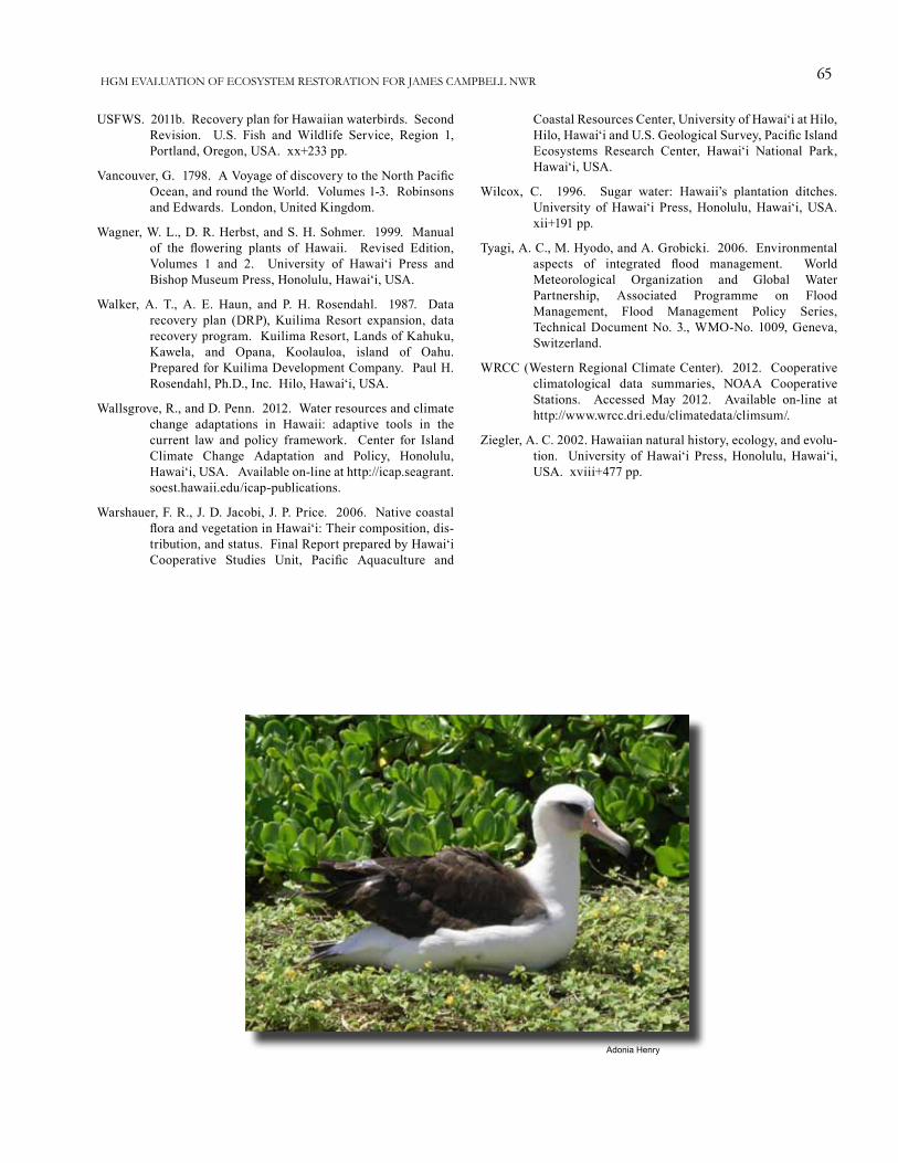
65HGM EVALUATION OF ECOSYSTEM RESTORATION FOR JAMES CAMPBELL NWR
Adonia Henry
USFWS. 2011b. Recovery plan for Hawaiian waterbirds. Second Revision. U.S. Fish and Wildlife Service, Region 1, Portland, Oregon, USA. xx+233 pp.
Vancouver, G. 1798. A Voyage of discovery to the North Pacific Ocean, and round the World. Volumes 1-3. Robinsons and Edwards. London, United Kingdom.
Wagner, W. L., D. R. Herbst, and S. H. Sohmer. 1999. Manual of the flowering plants of Hawaii. Revised Edition, Volumes 1 and 2. University of Hawai‘i Press and Bishop Museum Press, Honolulu, Hawai‘i, USA.
Walker, A. T., A. E. Haun, and P. H. Rosendahl. 1987. Data recovery plan (DRP), Kuilima Resort expansion, data recovery program. Kuilima Resort, Lands of Kahuku, Kawela, and Opana, Koolauloa, island of Oahu. Prepared for Kuilima Development Company. Paul H. Rosendahl, Ph.D., Inc. Hilo, Hawai‘i, USA.
Wallsgrove, R., and D. Penn. 2012. Water resources and climate change adaptations in Hawaii: adaptive tools in the current law and policy framework. Center for Island Climate Change Adaptation and Policy, Honolulu, Hawai‘i, USA. Available on-line at http://icap.seagrant.soest.hawaii.edu/icap-publications.
Warshauer, F. R., J. D. Jacobi, J. P. Price. 2006. Native coastal flora and vegetation in Hawai‘i: Their composition, dis-tribution, and status. Final Report prepared by Hawai‘i Cooperative Studies Unit, Pacific Aquaculture and
Coastal Resources Center, University of Hawai‘i at Hilo, Hilo, Hawai‘i and U.S. Geological Survey, Pacific Island Ecosystems Research Center, Hawai‘i National Park, Hawai‘i, USA.
Wilcox, C. 1996. Sugar water: Hawaii’s plantation ditches. University of Hawai‘i Press, Honolulu, Hawai‘i, USA. xii+191 pp.
Tyagi, A. C., M. Hyodo, and A. Grobicki. 2006. Environmental aspects of integrated flood management. World Meteorological Organization and Global Water Partnership, Associated Programme on Flood Management, Flood Management Policy Series, Technical Document No. 3., WMO-No. 1009, Geneva, Switzerland.
WRCC (Western Regional Climate Center). 2012. Cooperative climatological data summaries, NOAA Cooperative Stations. Accessed May 2012. Available on-line at http://www.wrcc.dri.edu/climatedata/climsum/.
Ziegler, A. C. 2002. Hawaiian natural history, ecology, and evolu-tion. University of Hawai‘i Press, Honolulu, Hawai‘i, USA. xviii+477 pp.
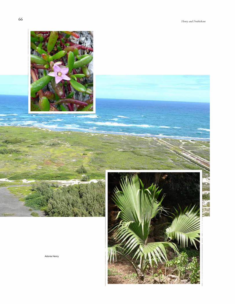
66 Henry and Fredrickson
Adonia Henry
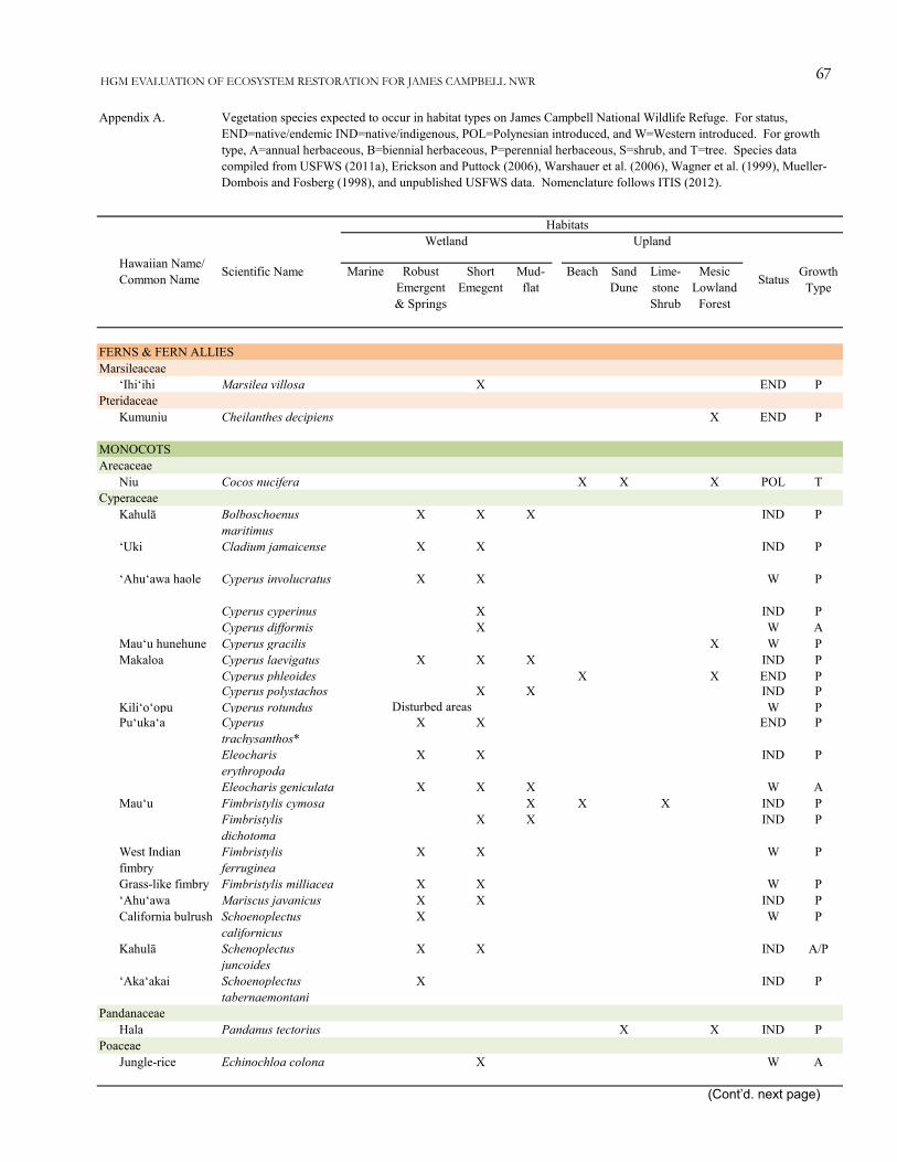
67HGM EVALUATION OF ECOSYSTEM RESTORATION FOR JAMES CAMPBELL NWR
Marine Robust Emergent & Springs
Short Emegent
Mud-flat
Beach Sand Dune
Lime-stone Shrub
Mesic Lowland
Forest
FERNS & FERN ALLIESMarsileaceae
‘Ihi‘ihi Marsilea villosa X END PPteridaceae
Kumuniu Cheilanthes decipiens X END P
MONOCOTSArecaceae
Niu Cocos nucifera X X X POL TCyperaceae
Kahulā Bolboschoenus maritimus
X X X IND P
‘Uki Cladium jamaicense X X IND P
‘Ahu‘awa haole Cyperus involucratus X X W P
Cyperus cyperinus X IND PCyperus difformis X W A
Mau‘u hunehune Cyperus gracilis X W PMakaloa Cyperus laevigatus X X X IND P
Cyperus phleoides X X END PCyperus polystachos X X IND P
Kili‘o‘opu Cyperus rotundus Disturbed areas W PPu‘uka‘a Cyperus
trachysanthos*X X END P
Eleocharis erythropoda
X X IND P
Eleocharis geniculata X X X W AMau‘u Fimbristylis cymosa X X X IND P
Fimbristylis dichotoma
X X IND P
West Indian fimbry
Fimbristylis ferruginea
X X W P
Grass-like fimbry Fimbristylis milliacea X X W P‘Ahu‘awa Mariscus javanicus X X IND PCalifornia bulrush Schoenoplectus
californicusX W P
Kahulā Schenoplectus juncoides
X X IND A/P
‘Aka‘akai Schoenoplectus tabernaemontani
X IND P
PandanaceaeHala Pandanus tectorius X X IND P
PoaceaeJungle-rice Echinochloa colona X W A
Appendix A. Vegetation species expected to occur in habitat types on James Campbell National Wildlife Refuge. For status, END=native/endemic IND=native/indigenous, POL=Polynesian introduced, and W=Western introduced. For growth type, A=annual herbaceous, B=biennial herbaceous, P=perennial herbaceous, S=shrub, and T=tree. Species data compiled from USFWS (2011a), Erickson and Puttock (2006), Warshauer et al. (2006), Wagner et al. (1999), Mueller-Dombois and Fosberg (1998), and unpublished USFWS data. Nomenclature follows ITIS (2012).
Growth Type
HabitatsUpland
Hawaiian Name/ Common Name Scientific Name Status
Wetland
(Cont’d. next page)
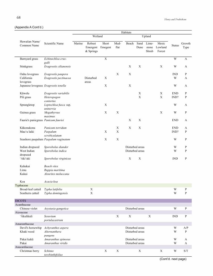
68 Henry and Fredrickson
Marine Robust Emergent & Springs
Short Emegent
Mud-flat
Beach Sand Dune
Lime-stone Shrub
Mesic Lowland
Forest
Growth Type
HabitatsUpland
Hawaiian Name/ Common Name Scientific Name Status
Wetland
Barnyard grass Echinochloa crus-galli
X W A
Stinkgrass Eragrostis cilianensis X X X W A
Oahu lovegrass Eragrostis paupera X X IND PCalifornia lovegrass
Eragrostis pectinacea Disturbed areas
X W A
Japanese lovegrass Eragrostis tenella X X W A
Kāwelu Eragrostis variabilis X X END PPili grass Heteropogon
contortusX X IND? P
Sprangletop Leptochloa fusca ssp. uninervia
X W A
Guinea grass Megathyrsus maximus
X X X W P
Faurie's panicgrass Panicum fauriei X X END A
Kākonakona Panicum torridum X X X END AMau‘u laiki Paspalum
scrobiculatumX X IND? P
Seashore paspalum Paspalum vaginatum X X W P
Indian dropseed Sporobolus diander Disturbed areas W PWest Indian dropseed
Sporobolus indica Disturbed areas W P
‘Aki‘aki Sporobolus virginicus X X IND P
Kahakai Beach vitexLimu Ruppia maritimaKukui Aleurites moluccana
Koa Acacia koaTyphaceae
Broad-leaf cattail Typha latifolia X W PSouthern cattail Typha domingensis X W P
DICOTSAcanthaceae
Chinese violet Asystasia gangetica Disturbed areas W PAizoaceae
‘Ākulikuli Sesuvium portulacastrum
X X X IND P
AmaranthaceaeDevil's horsewhip Achyranthes aspera Disturbed areas W A/PKhaki weed Alternanthera
pungensDisturbed areas W P
Pakai kukū Amaranthus spinosus Disturbed areas W APakai Amaranthus viridis Disturbed areas W A
AnacardiaceaeChristmas berry Schinus
terebinthifoliusX X X X W S/T
(Cont’d. next page)
(Appendix A Cont’d.)

69HGM EVALUATION OF ECOSYSTEM RESTORATION FOR JAMES CAMPBELL NWR
Marine Robust Emergent & Springs
Short Emegent
Mud-flat
Beach Sand Dune
Lime-stone Shrub
Mesic Lowland
Forest
Growth Type
HabitatsUpland
Hawaiian Name/ Common Name Scientific Name Status
Wetland
AraliaceaeOctopus tree Schefflera
actinophyllaX X X W T
AsteraceaeShrubland nehe Lipochaeta lobata* X X X END PSeside nehe Lipochaeta
succulentaX X END P
Kure Atoll nehe Melanthera integrifolia
X X END P
Pluchea carolinensis X X W S
Indian fleabane Pluchea indica X X W S‘Ena‘ena Pseudognaphalium
sandwicensiumX X END P
Pualele Sonchus oleraceus Disturbed areas W AGolden crown-beard
Verbesina encelioides Disturbed areas W A
Kīkānia/ Cocklebur
Xanthium strumarium X X Disturbed areas W A
BoraginaceaeKou Cordia subcordata X X POL T
Clasping heliotrope
Heliotropium amplexicaule
Disturbed areas W P
Hinahina Heliotropium anomalum var. argenteum
X X END P
Kīpūkai Heliotropium curassavicum
X X X IND P
Tree heliotrope Tournefortia argentea
X X X X W T
BrassicaceaeVeiny pepperweed
Lepidium oblongumDisturbed areas W A/B
CapparaceaeMaiapilo Capparis
sandwichianaX X X END S
ChenopodiaceaeNettleleaf goosefoot
Chenopodium murale Disturbed areas W A
‘Āheahea Chenopodium oahuense
X X X END P
ClusiaceaeKamani Calophyllum
inophyllumX POL T
CombretaceaeFalse kamani
Terminalia catappaX X X X W T
ConvolvulaceaeMoon flower Ipomoea alba X X W PSwamp cabbage Ipomoea aquatica X W P‘Uala Ipomoea batatas Abandoned homesites POL PKoali Ipomoea cairica Disturbed rocky areas IND? P
(Cont’d. next page)
(Appendix A Cont’d.)

70 Henry and Fredrickson
Marine Robust Emergent & Springs
Short Emegent
Mud-flat
Beach Sand Dune
Lime-stone Shrub
Mesic Lowland
Forest
Growth Type
HabitatsUpland
Hawaiian Name/ Common Name Scientific Name Status
Wetland
Hunakai Ipomoea imperati X X IND PKoali ‘awa Ipomoea indica X X IND PWhiteflower beach morning glory
Ipomoea littoralis X X IND? P
Obscure morning glory
Ipomoea obscura Disturbed areas W P
Pōhuehue Ipomoea pes-caprae X X IND P
Little bell Ipomoea triloba Disturbed areas W PBeach moonflower Ipomoea violacea X X W P
Pā‘ūohi‘iaka Jacquemontia ovalifolia
X X X IND P
CucurbitaceaeKūpala Sicyos pachycarpus X X X END P
CuscutaceaeKauna‘oa Cuscuta
sandwichianaX X X X END A/P
Euphorbiaceae‘Akoko Euphorbia
celastroidesX X END S
‘Akoko Euphorbia degeneri X X END SParasol leaf tree Macaranga tanarius X W TPā‘aila Ricinus communis Disturbed areas W S/T
FabaceaeWiliwili Erythrina
sandwicensisX END T
Koa haole Leucaena leucocephala
X X W S/T
Pua hilahila Mimosa pudica Disturbed areas W A/PKā‘e‘e/sea bean Mucuna gigantea X X X X IND P/SKiawe Prosopis pallida X X X W TKolomona Senna gaudichaudii X IND S
‘Ohai Sesbania tomentosa* X X END S
Nanea Vigna marina X X IND PO‘ahu cowpea Vigna owahuensis* X END A/P
Gentianaceae‘Āwiwi Schenkia sebaeoides X END A
GoodinaceaeDwarf naupaka Scaevola coriacea* X X END P/S
Naupaka kuahiwi Scaevola gaudichaudii
X END S
Naupaka kahakai Scaevola sericea X X X IND SHydrophyllaceae
Hinahina kahakai Nama sandwicensis X X END A/P
(Cont’d. next page)
(Appendix A Cont’d.)

71HGM EVALUATION OF ECOSYSTEM RESTORATION FOR JAMES CAMPBELL NWR
Marine Robust Emergent & Springs
Short Emegent
Mud-flat
Beach Sand Dune
Lime-stone Shrub
Mesic Lowland
Forest
Growth Type
HabitatsUpland
Hawaiian Name/ Common Name Scientific Name Status
Wetland
LamiaceaeChristmas candlestick
Leonotis nepetifolia X Disturbed areas W A
LauraceaeKauna‘oa pehu Cassytha filiformis X X IND P
MalvaceaeHairy Indian mallow
Abutilon grandifolium Disturbed areas W S
Sea island cotton Gossypium barbadense
Disturbed areas W S
Ma‘o Gossypium tomentosum
X X X END S
Common wireweed
Sida acuta X X X X W P
‘Ilima Sida fallax X X IND SArrowleaf sida Sida rhombifolia Disturbed areas W? SHau Talipariti tiliaceum Ditches IND? S/T
Milo Thespesia populnea X X X IND? T
MenispermaceaeHuehue Cocculus orbiculatus X X IND P
MyoporaceaeNaio Myoporum
sandwicenseX X IND S/T
NyctaginaceaeScarlet spiderling Boerhavia coccinea Disturbed areas W P
Alena Boerhavia diffusa X X X IND PAlena Boerhavia herbstii X X X END PAlena Boerhavia repens X X X IND P
OnagraceaeKāmole Ludwigia octovalvis X POL? P
Marsh purslane Ludwigia palustris X W PPlantaginaceae
Narrow-leaved plantain
Plantago lanceolata X X X X W B/P
Laukahi Plantago major X X X X X W PPlumbaginaceae
‘Ilie‘e Plumbago zeylanica X X IND P/S
Portulacaceae‘Ihi Portulaca lutea X X X X IND P‘Ihi Portulaca villosa X X END P
PrimulaceaeScarlet pimpernel Anagallis arvensis X X W A/B/P
RhizophoraceaeAmerican mangrove
Rhizophora mangle X X W T
(Cont’d. next page)
(Appendix A Cont’d.)
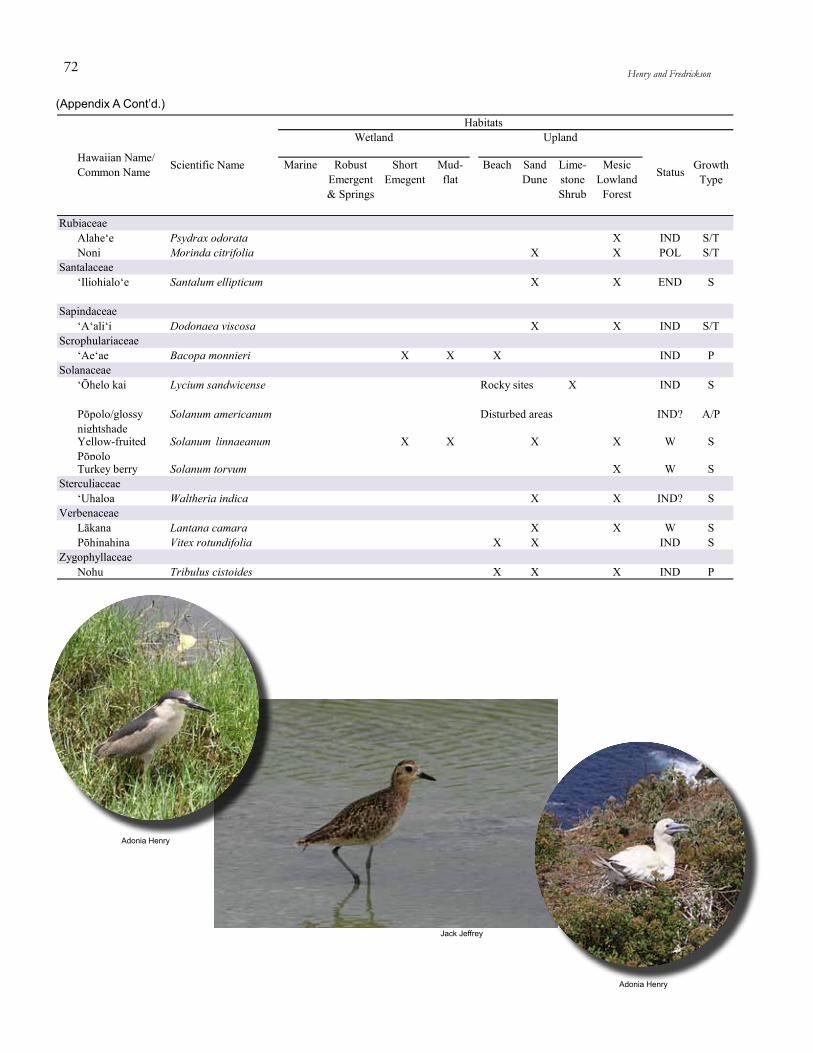
Adonia Henry
Adonia Henry
Jack Jeffrey
72 Henry and Fredrickson
Marine Robust Emergent & Springs
Short Emegent
Mud-flat
Beach Sand Dune
Lime-stone Shrub
Mesic Lowland
Forest
Growth Type
HabitatsUpland
Hawaiian Name/ Common Name Scientific Name Status
Wetland
RubiaceaeAlahe‘e Psydrax odorata X IND S/TNoni Morinda citrifolia X X POL S/T
Santalaceae‘Iliohialo‘e Santalum ellipticum X X END S
Sapindaceae‘A‘ali‘i Dodonaea viscosa X X IND S/T
Scrophulariaceae‘Ae‘ae Bacopa monnieri X X X IND P
Solanaceae‘Ōhelo kai Lycium sandwicense Rocky sites X IND S
Pōpolo/glossy nightshade
Solanum americanum Disturbed areas IND? A/P
Yellow-fruited Pōpolo
Solanum linnaeanum X X X X W S
Turkey berry Solanum torvum X W SSterculiaceae
‘Uhaloa Waltheria indica X X IND? SVerbenaceae
Lākana Lantana camara X X W SPōhinahina Vitex rotundifolia X X IND S
ZygophyllaceaeNohu Tribulus cistoides X X X IND P
(Appendix A Cont’d.)

73HGM EVALUATION OF ECOSYSTEM RESTORATION FOR JAMES CAMPBELL NWR
Marine Robust Emergent
and Springs
Short Emergent
Mudflat Beach Sand Dune
Lime-stone Shrub
Mesic Lowland Forest
FISHCarangidae
Giant Trevally (papio)/ Ulua au kea
Caranx ignobilis x
ChanidaeAwa/Milkfish Chanos chanos x x
CichlidaeMozambique Tilapia
Oreochromis mossambicus
x x x W
Black-chin Tilapia Sarotherodon melanotheron
x x x W
Redbelly Tilapia Tilapia zillii x x x WMugilidae
‘Ama‘ama/Mullet Mugil cephalus x xAcute-jawed Mullet
Neomyxus leuciscus x
Engel's Mullet Valamugil engeli xPoeciliidae
I‘a makika/Western
Gambusia affinis x x W
Cuban Molly Limia vittata x x WSailfin Molly Poecilia latipinna x x WShortfin Molly Poecilia mexicana x x WMolly Poecilia sp. hybrid x x W
SynodontidaeGracile Lizardfish Saurida gracilis x
AMPHIBIANSBufonidae
Poloka/Cane Toad Rhinella marina x x x x x WRanidae
American Bullfrog Lithobates catesbeianus
x x W
REPTILESCheloniidae
Honu/Green Sea Turtle
Chelonia mydas x x IND
GekkonidaeMo‘o ‘alā/ Common House Gecko
Hemidactylus frenatus
Human structures POL
PolychrotidaeGreen Anole Anolis carolinensis x x x x W
Scincidae Rainbow Skink Lampropholis
delicatax x W
TyphlopidaeBlind Snake Ramphotyphlops
braminusx x x W
Status
Appendix B. Vertebrate and invertebrate species expected to occur in vegetation community types at James Campbell National Wildlife Refuge. For status, END=native/endemic IND=native/indigenous, MIG=native/migratory, EXT=Extinct, EXT/O=Extirpated from O‘ahu, POL=Polynesian introduced, and W=Western introduced. Species data compiled from Poole (2012), USFWS (2011a), Culliney (2006), and Mitchell et al. (2005). Nomenclature follows ITIS (2012).
HabitatsUpland
Hawaiian or Common Name Scientific Name
Wetland
(Cont’d. next page)

74 Henry and Fredrickson
Marine Robust Emergent
and Springs
Short Emergent
Mudflat Beach Sand Dune
Lime-stone Shrub
Mesic Lowland Forest
Status
HabitatsUpland
Hawaiian or Common Name Scientific Name
Wetland
BIRDSAnseriformesAnatidae
Greater White-fronted Goose
Anser albifrons x x x x MIG
Black Brant Branta bernicla x x x x MIGCackling Goose Branta hutchinsii x x x MIGCanada Goose Branta canadensis x x x MIGNēnē/Hawaiian Goose
Branta sandvicensis x x x x x END
Nēnē-nui Branta hylobadistes x? x? x? x? x? EXTKoloa Maoli/ Hawaiian Duck
Anas wyvilliana x x x x x END
Mallard Anas platyrhunchos x x x MIGGadwall Anas strepera x x MIGKoloa Māpu/ Northern Pintail
Anas acuta x x MIG
American Wigeon Anas americana x x x MIGEurasian Wigeon Anas penelope x x x MIGKoloa Mohā/ Northern Shoveler
Anas clypeata x x MIG
Cinnamon Teal Anas cyanoptera x x MIGBlue-winged Teal Anas discors x x MIGGreen-winged Anas crecca x x x MIGMoa Nalo Thambetochen x? x? x? x? x? EXTCanvasback Aythya valisineria x x x MIGRedhead Aythya americana x x x MIGRing-necked Duck Aythya collaris x x MIGLesser Scaup Aythya affinis x x MIGGreater Scaup Aythya marila x x MIGTufted Duck Aythya fuligula x x MIGBufflehead Bucephala albeola x x x MIGCommon Merganser
Mergus merganser x x x MIG
GalliformesNumididae
Helmeted Guineafowl
Numida meleagris x x W
PhasianidaeRing-necked Pheasant
Phasianus colchicus x x x x x W
Pīkake/Common Peafowl
Pavo cristatus x x W
ProcellariiformesDiomedeidae
Mōlī/Laysan Albatross
Phoebastria immutabilis
x x x IND
Ka‘upu/Black-footed Albatross
Phoebastria nigripes x x x x IND
ProcellariidaeHawaiian Dark-rumped Petrel
Pterodroma sandwichensis
x x x EXT/O
Bonin Petrel Pterodroma hypoleuca
x x EXT/O
Pterodroma jugabilis x x? x? EXT(Cont’d. next page)
(Appendix B Cont’d.)

75HGM EVALUATION OF ECOSYSTEM RESTORATION FOR JAMES CAMPBELL NWR
Marine Robust Emergent
and Springs
Short Emergent
Mudflat Beach Sand Dune
Lime-stone Shrub
Mesic Lowland Forest
Status
HabitatsUpland
Hawaiian or Common Name Scientific Name
Wetland
‘Ua‘u Kani/Wedge-tailed Shearwater
Puffinus pacificus x x x IND
HydrobatidaeBand-rumped Storm Petrel
Oceanodroma castro x x EXT/O
PhaethontiformesPhaethontidae
Koa‘e Kea/White-tailed Tropicbird
Phaethon lepturus x x IND
Koa‘e ‘ula/Red-tailed Tropicbird
Phaethon rubricauda x x x IND
SuliformesFregatidae
‘Iwa/Great Frigatebird
Fregata minor x x x x IND
Sulidae‘Ā/Red-footed Booby
Sula sula x x x x IND
PelecaniformesArdeidae
Great Blue Heron Ardea herodias x x MIGSnowy Egret Egretta thula x x MIGCattle Egret Bubulcus ibis x x x x x x x W‘Auku‘u/ Black-crowned Night Heron
Nycticorax nycticorax
x x x IND
ThreskiornithidaeWhite-faced Ibis Plegadis chihi x x MIG
AccipitriformesPandionidae
Osprey Pandion haliaetus x x x MIGAccipitridae
Northern Harrier Circus cyaneus x x x x x x MIGLong-legged Harrier
Circus dossensu x? x? x? x? x? x? EXT
Sea Eagle Haliaeetus sp. x x? x? x? x? x? x? EXT‘Io/Hawaiian Buteo solitarius x EXT/OHawk Buteo sp. x? EXT
FalconiformesFalconidae
Peregrine Falcon Falco peregrinus x x x x x x x MIG
GruiformesRallidae
Flightless Rail Porzana ralphorum x EXTFlightless Rail Porzana ziegleri x EXTHawaiian Rail Porzana
sandwichensisx EXT
‘Alae ‘ula/ Hawaiian Moorhen
Gallinula galeata sandvicensis
x x x END
‘Alae ke‘o ke‘o/ Hawaiian Coot
Fulica alai x x END
CharadriiformesCharadriidae
Black-bellied Plover
Pluvialis squatarola x x x x MIG
(Cont’d. next page)
(Appendix B Cont’d.)

76 Henry and Fredrickson
Marine Robust Emergent
and Springs
Short Emergent
Mudflat Beach Sand Dune
Lime-stone Shrub
Mesic Lowland Forest
Status
HabitatsUpland
Hawaiian or Common Name Scientific Name
Wetland
Kōlea/Pacific Golden-plover
Pluvialis fulva x x x x x MIG
Semipalmated Plover
Charadrius semipalmatus
x x x MIG
Killdeer Charadrius x x x MIGRecurvirostridae
Ae‘o/Hawaiian Black-necked Stilt
Himantopus mexicanus knudseni
x x x END
ScolopacidaeSpotted Sandpiper Actitis macularia x x x MIGSolitary Sandpiper Tringa solitaria x x x MIG‘Ūlilī/Wandering Tattler
Tringa incana x x x x MIG
Greater Tringa melanoleuca x x x x MIGLesser Yellowlegs Tringa flavipes x x MIGMarsh Sandpiper Tringa stagnatilis x x x MIGWhimbrel Numenius phaeopus x x x x x MIGKioea/Bristle-thighed Curlew
Numenius tahitiensis x x x x x x MIG
Bar-tailed Godwit Limosa lapponica x x x MIG‘Akekeke/Ruddy Turnstone
Arenaria interpres x x MIG
Red Knot Calidris canutus x x MIGHunakai/Sanderlin Calidris alba x x MIGSemipalmated Sandpiper
Calidris pusilla x x x MIG
Western Sandpiper Calidris mauri x x MIG
Least Sandpiper Calidris minutilla x x x x MIGPectoral Sandpiper Calidris melanotos x x MIGSharp-tailed Sandpiper
Calidris acuminata x x MIG
Dunlin Calidris alpina x x x MIGStilt Sandpiper Calidris himantopus x x MIGRuff Philomachus pugnax x x MIGShort-billed Dowitcher
Limnodromus griseus
x x x MIG
Long-billed Dowitcher
Limnodromus scolopaceus
x x MIG
Common Snipe Gallinago gallinago x x MIGWilson's Phalarope Phalaropus tricolor x x When
FloodedMIG
LaridaeBonaparte's Gull Chroicocephalus
philadelphia x x x x x MIG
Laughing Gull Leucophaeus x x MIGFranklin's Gull Leucophaeus x x MIGRing-billed Gull Larus delawarensis x x x x MIGWestern Gull Larus occidentalis x x MIGHerring Gull Larus argentatus x x MIGThayer's Gull Larus glaucoides x x MIGGlaucous-winged Gull
Larus glaucescens x x MIG
White Tern Gygis alba x x x x INDLeast Tern Sternula antillarum x x x x MIGGull-billed Tern Gelochelidon
nilotica x x x x MIG
(Cont’d. next page)
(Appendix B Cont’d.)

77HGM EVALUATION OF ECOSYSTEM RESTORATION FOR JAMES CAMPBELL NWR
Marine Robust Emergent
and Springs
Short Emergent
Mudflat Beach Sand Dune
Lime-stone Shrub
Mesic Lowland Forest
Status
HabitatsUpland
Hawaiian or Common Name Scientific Name
Wetland
Caspian Tern Hydroprogne caspia x x x MIGCommon Tern Sterna hirundo x x x x MIGArctic Tern Sterna paradisaea x x MIGSandwich Tern Thalasseus
sandvicensis x x MIG
ColumbiformesColumbidae
Rock Pigeon Columbia livia x x WSpotted Dove Streptopelia x x x WZebra Dove Geopelia striata x x WMourning Dove Zenaida macroura x x W
PsittaciformesCacatuidae
Sulphur-crested Cockatoo
Cacatua galerita
StrigiformesTytonidae
Barn Owl Tyto alba x x x Human Structures x WStrigidae
Pueo/Hawaiian Short-eared Owl
Asio flammeus sandwichensis
x x x x x END
Long-legged Owl Grallistrix orion x? x? x? x? x? EXTPasseriformesCorvidae
‘Alalā/Hawaiian Crow
Corvus hawaiiensis x? x? EXT/O
Large Crow Corvus impulviatus EXTLarge Crow Corvus viriosus EXT
PycnonotidaeRed-vented Bulbul Pycnonotus cafer x x W
CettidaeJapanese Bush-warbler
Cettia diphone x x W
ZosteropidaeJapanese White-eye
Zosterops japonicus x x W
TurdidaeWhite-rumped Shama
Copsychus malabaricus
x x x W
SturnidaeCommon Myna Acridotheres tristis W
Cardinalidae x x xNorthern Cardinal Cardinalis cardinalis x x x x WRed-crested Cardinal
Paroaria coronata x W
FringillidaeHouse Finch Carpodacus
mexicanus x x x W
PasseridaeHouse Sparrow Passer domesticus Human structures W
EstrildidaeCommon Waxbill Estrilda astrild x x x WRed Avadavat Amandava x x WNutmeg Mannikin Lonchura punctulata x x x WChestnut munia Lonchura atricapilla x x WJava Sparrow Padda oryzivora x x W
(Cont’d. next page)
(Appendix B Cont’d.)

78 Henry and Fredrickson
Marine Robust Emergent
and Springs
Short Emergent
Mudflat Beach Sand Dune
Lime-stone Shrub
Mesic Lowland Forest
Status
HabitatsUpland
Hawaiian or Common Name Scientific Name
Wetland
MAMMALSChiroptera
‘Ōpe‘ape‘a/ Hawaiian Hoary Bat
Lasiurus cinereus semotus
x x x x x x END
Rodentia‘Iole/Polynesian Rat
Rattus exulans x x x x x x POL
‘Iole/Norway Rat Rattus norvegicus x x x x x x W‘Iole/Black Rat Rattus rattus x x x x x x W‘Iole/House Mouse Mus musculus x x x x x x W
Carnivora‘Īlioholoikauaua/ Hawaiian monk seal
Monachus schauinslandi
x x END
Manakuke/Indian mongoose
Herpestes auropunctatus
x x x x x x x W
‘Īlio/Dog Canis familiaris x x x x x x x POLPōpoki/Cat Felis catus x x x x x x W
ArtiodactylaPua‘a/Pig Sus scrofa x x x x x x POL/W
INVERTEBRATESPhylum MolluscaClass Gastropoda
‘Opihi/Limpet Pyrgophorus coronatus
x IND
Class BivalviaAsian clam Corbicula fluminea x x WClam Corbicula sp.
Phylum ArthropodaClass Arachnida
Cane Spider Heteropoda venatoria
x x x x W
Kopiana/Lesser Brown Scorpion
Isometrus maculatus x x x x W
Class ChilopodaKanapī/Centipede Scolopendra
subspinipesx W
Class Malacostraca, Order DecapodaAnchialine Snapping Shrimp
Metabetaeus lohena* x END
‘Ōpae Pake Crayfish
Procambarus clarkii x x W
Mud Crab Scylla serreta x x WCrenate swimming Crab
Thalamita crenata x W
Crab Thalamita edwardsi x W‘Ōpae Huna Feeble Shrimp
Palaemon debilis x IND
Freshwater Prawn Macrobrachium rosenbergii
x x W
‘Ōpae ‘Ula Hawaiian Red Shrimp
Halocaradiana rubra x END
(Cont’d. next page)
(Appendix B Cont’d.)

Adonia Henry
79HGM EVALUATION OF ECOSYSTEM RESTORATION FOR JAMES CAMPBELL NWR
Marine Robust Emergent
and Springs
Short Emergent
Mudflat Beach Sand Dune
Lime-stone Shrub
Mesic Lowland Forest
Status
HabitatsUpland
Hawaiian or Common Name Scientific Name
Wetland
Class Insecta, Order OdonataRambur's Forktail Damselfly
Ischnura ramburii x x x W
Class Insecta, Order HemipteraWater Strider Halobates
hawaiiensisx IND
Class Insecta, Order DipteraAsian Tiger Mosquito
Aedes albopictus x x x x x x x W
Southern House Mosquito
Culex quinquefasciatus
x x x x x x x W
(Appendix B Cont’d.)
