i li . stratosphere i l
TRANSCRIPT

TOPIC 2REVIEW QUESTIONS
Measuring Earth
1. Whichobject best represents a true scale modelofthe shape of Earth? (1)a table tennis ball(2)a football (3)an egg (4)a pear
2. Whichof the followingisNOTevidence that supportsEarth'ssphericalshape? (1)photographs taken fromouter space (2)ships appearing to sinkas theysailpast the horizon (3)the changing seasons(4)the similaritiesin gravityat sea levelallover Earth
3. Inwhich group are the spheres of Earth listed inorder of increasing density? (1)atmosphere, hydro-sphere,lithosphere (2)hydrosphere,lithosphere,atmosphere (3)lithosphere, hydrosphere, atmos-phere (4)lithosphere,atmosphere, hydrosphere
4. Whichmakes up most of Earth'ssurface? (1)theatmosphere (2)the lithosphere (3)the hydrosphere
5. The lower atmosphere and hydrosphere are boundto Earth by (1) magnetic fields (2) atmosphericpressure (3) the force of gravity (4) a molecularbonding at the interface
6. What do the tropopause, stratopause, andmesopause all have in common? (1) Each is a point ofmaximum temperature in its layer of the atmosphere.(2) Each is an interface of two layers of theatmosphere. (3) Each is a region of increasingpressure within the atmosphere. (4) Each is a zoneof decreasing water vapor content within theatmosphere.
7. As depth within Earth's interior increases, the(1) density, temperature, and pressure decrease(2) density, temperature, and pressure increase(3) density and temperature decrease, but pressureincreases (4) density decreases, but temperatureand pressure increase
~.
NAMESET
8. The following diagram shows Earth's spheres.Which spheres are zones of Earth's atmosphere?(1) lithosphere, hydrosphere; and troposphere(2) stratosphere, mesosphere, and thermosphere(3) asthenosphere, lithosphere, and hydrosphere(4) hydrosphere, troposphere, and stratosphere
Mantle
. Asthenosphere
LithosphereHydrosphere
. ILIIL,,",,..,I-,I,,-I Thermosphere
Troposphere
Stratosphere.
. Mesosphere
.
(Not drawn to scale.)
9. The layerof bedrock near Earth'ssurface that formsa continuous shell around Earthiscalledthe(1)troposphere (2)stratosphere (3)lithosphere(4)hydrosphere
10. Oxygen isthe most abundant element by volume inEarth's (1)inner core (2)crust (3)hydrosphere(4)troposphere
11. What is the approximate altitude of the mesopausein the atmosphere? (1)50 km (2)66 km (3)82 km(4)90 km
12. Which statement most ac(.:uratelydescribes Earth'satmosphere? (1)The atmosphere is layered,witheach layerpossessing distinct characteristics.(2)The atmosphere is a mass of gases surroundingmost of Earth. (3)The atmosphere's altitude is lessthan the depth of the ocean. (4)The atmosphere ismore dense than the hydrosphere, but lessdensethan the lithosphere.
13. Which layer of Earth's atmosphere contains no watervapor, has an atmospheric pressure less than 10-4atmosphere, and has an air temperature thatincreases with altitude? (1) troposphere(2) stratosphere (3) mesosphere (4) thermosphere
14. The water sphere of Earth is known as the(1) atmosphere (2) troposphere (3) lithosphere(4) hydrosphere
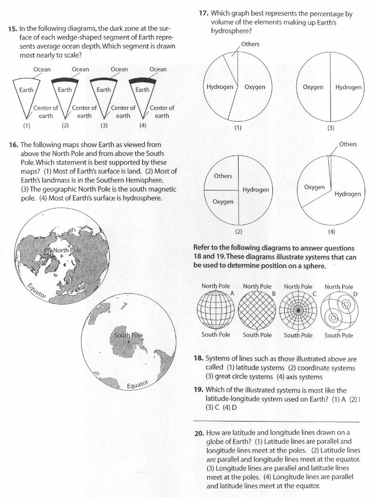
15. In the following diagrams,the dark zone at the sur-face of eachwedge-shaped segment of Earthrepre-sents averageocean depth. Which segment is drawnmostnearlyto scale? .
Ocean Ocean Ocean Ocean
(1) (3) (4)(2)
16. The following maps show Earth as viewed fromabove the North Pole and from above the South
Pole.Which statement is best supported by thesemaps? (1) Most of Earth's surface is land. (2) Most ofEarth's landmass is in the Southern Hemisphere.
(3) The geographiC North Pole is the south magnetic
pole. (4) Most of Earth's surface is hydrosphere.
EqU3\.O~
17. Which graph best representsthe percentage byvolume ofthe elements making up Earth'shydrosphere?
Others
(1) (3)
Others
(2) (4)
Refer to the following diagrams to answer questions18 and 19.Thesediagrams illustrate systems that canbe used to determine position on a sphere.
North PoleI
ANort~ Pole
C
South Pole South Pole South Pole
18. Systems of lines such as those illustrated above are
called (1) latitude systems (2) coordinate systems(3) great circle systems (4) axis systems
19. Which of the illustrated systems is most like thelatitude-longitude system used on Earth? (1) A (2) I(3) C (4) D
20. How are latitude and longitude lines drawn on aglobe of Earth? (1) Latitude lines areparallel andlongitude lines meet at the poles. (2)Latitude linesare parallel and longitude lines meet at the equator.(3) Longitude lines are parallel and latitude linesmeet at the poles. (4) Longitudelines are paralleland latitude lines meet at the equator.

21. -Inthe following diagram, what is the latitude of theobserver?
./"ToPolaris/'
Tohorizon ~
(1) 30° N (2) 60° N (3) 90° N (4) 120° N
22. What happens to the altitude of Polaris as you travelnorthward?
23. Polaris is used as a celestial reference point forEarth's latitude system because Polaris (1) alwaysrises at sunset and sets at sunrise (2) is located overEarth's axis of rotation (3) can be seen from any
place on Earth (4) is a very bright star
24. _Anairplane takes off from a location at 1TS latitudeand flies to a new location 55° due north of its start-
ing point. What latitude has the airplane reached?(1) 28° N (2) 38° N (3) 55° N (4) 72° N
25. Which diagram best shows the altitude of Polarisobserved near Buffalo,New York?
ToPolaris
- ! 70°
cr.- NorthernObserver Horizon
(3)
ToPolaris
~- NorthernObserver Horizon
(1)
Tor:ooIT- NorthernObserver Horizon
(4)
To Polaris
/\43°~ Northern
Observer Horizon(2)
26. Which reference line passes through both the geo-graphic North Pole and the geographic South Pole?(1) 0° latitude (2) 0° longitude (3)Tropic of Cancer(23 ~ ° S) (4)Tropic of Capricorn (23 ~ ° N)
27-. A person knows the sun time on the Prime Meridianand the local sun time. What determination can be
made? (1) the date (2) the altitude of Polaris(3) the longitude at which the person is located(4) the latitude at which the person is located
28. The following diagram represents a portion ofEarth's latitude and longitude system. What are theapproximate latitude and longitude of point A?(1)15°S200W (2)15°S200E (3)15°N200W(4) 15° N 20° E
45° 30° 15° 0° 15° 30° 45°30°
Ae20°
lOON
0° r
10°
20°
30°
29. What is the location of Binghamton, New York?(1) 42°06' N,75°55'W (2) 42°06' S,76°05'W(3) 42°S4' N,76°0S'W (4) 42°54' N,7SoSS'W
30. Which New York landscape region includes the loca-tion 43°30' N,75°45'W? (1) Adirondack Mountains(2) Erie-Ontario Lowlands (3) St. Lawrence Lowlands(4)Tug HillPlateau
31. The following isoline map shows the variations inthe relative strength of Earth's magnetic field from 1(strong) to 11 (weak).
Which of Earth's plates has the weakest magneticfield strength? (1) South American plate (2) Africanplate (3) North American plate(4) Pacific plate

32. The following four temperature field maps representthe same region on four different occasions.Allmaps have been drawn to the samescale.Whichmap showsthe greatest temperature field gradient?
33. One thermometerthat is held 2 meters above the
floor shows a temperature of 30°(, A thermometeron the floor shows atemperature of 24°(, What is
the temperature gradient between the two ther-mometers? (1) 6°C/m (2)2°C/m (3)3°C/m(4) 4°C/m
34. As gradient increases, what happens to the distancebetween isolines?
Baseyour answers to questions 35 through 44 on themap in Figure 2-8.
35. What is the maximum altitude of Denman Orchard?(1) 140 feet (2) 150 feet (3) 159 feet (4) 161 feet
36. What isthe longitude of the middle of RomanoSwamp? (1) 37"47' North (2) 37"47' West(3) 74°31' North (4) 74°31 'West
37. What isthe distancefrom PassasStreetat the mar-gin of the map to where it meets Route84? (1)2 ~
miles (2)3 miles (3)3 ~ miles (4)4 miles
38. What is the gradient of the Brigitte River from the200-foot contour line to the contour line before the
BrigitteRivermeets the Newburgh River? (1)5 to 10feet/mile (2) 15 to 20 feet/mile (3) 25 to 30feet/mile (4) 35 to 40 feet/mile
39. What is the latitude of the church? (1) 74°32' North(2) 74°32'West (3) 37°41 'West (4) 37"41' North
40. Where is the steepest slope located on the map?
41. The biggest areaof gentle slopes isfound in thevicinity of (1)GareyPond (2)Denman Orchard(3) PaulHill (4)Zemp Creek
42. Which direction isVailsGate Ridgefrom CallisterCity? (1)north (2) northwest (3)northeast (4)west
43. Toward what direction isthe BrigitteRiverflowing?(1)south (2)southwest (3) north (4)northeast
44. Which of the following profilesrepresents the shapeof the landscape between Aand Bon the map?
45. On the following topographic map,what isthe mostlikely elevation of point A? (1) 1250km (2) 1650 km(3) 1750km (4) 1850km
N
i OtlH22tScale(Kilometers)
- - -
46. What is the approximate straight-linedistance fromMt. Marcy in the Adirondacksto SlideMountain inthe Catskills? (1) 120km (2) 150km (3)205 km(4)235 km
Baseyouranswersto questions47and 48on thefollowing diagram, which represents a topographicmap of a hill.
E r""I r""I I01234Kilometers100
S
eontour interval=l 0 meters
47. On which side of the hill does the land havethesteepestslope? (1)east (2)south (3)northeast(4) northwest
48. What is the approximate gradient of the hillbetween points X and Y? [Refer to the Earth ScienceReferenceTables] (1) 1 m/km (2) 10m/km(3)3 m/km (4) m/km
ocI11°e '\.. 12'(
lOoe 1ooe
(1) (3)'"
o. 20oe
15°e '\. 28°e
26°e
(2) (4)
2 3 4
- -t:=A B A B A B A B
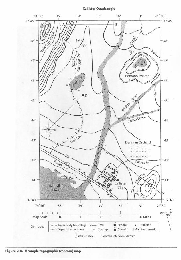
Callister Quadrangle
74°36'I
37"49'
35' 34' 33' 32' 31' 74°30'I
37"49'
41'
48'48'
47' 47'
46' 46'
45' 45'
44' 44'
43' 43'
42' 42'
41'
II I I II I I r
Map Scale 0
L2
37"40'
74°36' 35' 34' 33'
Symbols Water body boundary
u.u.L Depression contours
Trail
:>Ik Swamp
i inch =1 mile Contour interval =20 feet
Figure 2-8. Asampletopographic(contour)map
X'
- 37"40'I
32' 31' 74.30'*
I I MN3 .4 Miles
.. School . Buildingit.Church BM X Bench mark

TOPIC 2QUESTIONS FOR REGENTS PRACTICE
Measuring EarthSET
Part A1. The latitude of an observer on Earth's surface can be
determined by measuring the altitude of Polarisbecause Earth has a
(1) nearly spherical shape
(2) nearly circular orbit around the sun
(3) variable length of day
, (4)fairlyconstant period of revolution
.2. Which line best identifies the interface of the litho-
sphere and the troposphere?
Outer space 5'-'0"-::::-
~ un- .....
D /,,'
~~~Atmosphere
(Not to scale.)
(1) A (2) 8 (3) ( (4) D
3. The following data table shows the altitude ofPolaris as recorded by four observers at differentlocations on Earth.
Which statement is best supported by the informa-tion in the table?
(1) Observer A was at the equator.
(2) Observers A and 8 measured the altitude duringdaytime hours.
(3) Observers 8 and ( measured the altitude at thesame latitude.
(4) Observers 8, (, and D were in the SouthernHemisphere.
NAME
4. Which latitude and longitude coordinates represla location on the continent of Australia?
(1) 20° N, 1350 E
(2) 200 N,1350 W
(3) 20° 5,135° E
(4) 20° 5,1350 W
5. Which statement is true about an isoline on an air
temperature field map?
(1) It represents an interface of high and low bammetric pressures.
(2) It indicates the direction of maximull) insolatio
(3) It increases in magnitude as it bends southwan
(4) It connects points of equal air temperature.
6. Which of the following items is a model?
(1) a globe
(2) a ruler
(3) a hand lens
(4) a mineral specimen
7. The following map represents an elevation field.
Which graph best represents the elevation profilealong a straight line from point Ato point B?
Observer Altitude of Polaris
A 90°
8 30°
( 30°
D 20°t30
13OOC:c 260 c 260. 220 \f\ .g 220 \r
180 180
ill A Bw
A B
(1) (3)
t 3DOl: t30°t::c 260 5260-. 220 r-..../ 'p 220'"180 180-
ill A Bw
A B
(2) (4)

Baseyour answers to questions 8 through 12 on thefollowing topographic map of an island. Points Athrough G represent locations on the island. Elevationsare in meters.
AtlanticOcean
r---T0 1
I , I ,2 3 4 5 km
8. Which point is located on the steepest slope?
(1) F
(2) B
(3) C
(4) 0
9. In which direction does the Cinder River flow?
(1) southeast
(2) southwest
(3) northeast
(4) northwest
10. What is the contour interval for this map?
(1)10m
(2) 15 m
(3) 20 m(4) 25 m
11. Which two points have the same elevation?". .
(1)Gand F
(2)Band 0
(3)Cand 0
(4) G and C
12. Whichdiagram best represents the topographicprofilebetween location Cand location B?
£120c.g 80
""
><IJ
i:i::i 40
(1)
£120c.g 80
""
><IJ
i:i::i 40
(2)
£120
B
B
13. A movement of volcanic ash occurred at an altitude
. of 1.5kilometers.Inwhich layer of Earth'satmos-phere did the ash cloud travel?
(1) troposphere
(2) stratosphere
(3) mesosphere
(4) thermosphere
14. What is the distance in degrees east or west of theprime meridian called?
(1) longitude
(2) latitude
(3) equator
(4) altitude
15. The followingdiagram represents contour lineson atopographic map with cross-section lineAB.
'fEe O~)BWhich diagram best represents the topographic pro-filealong line AB?
A(1)
A(2)
B BA(3)
B BA(4)
B(3)
£120c.51 80ta>
40
CB(4)

PartBThe following topographic map shows a portion of anarea of inactive volcanoes in the United States.Thecontour interval is 20 feet. Base your answers to ques-tions 16 through 20 on this diagram. REMEMBER:State directions or units of measure when appropriate.
48°35'A+2148 F
Mt.Kerr
'\c
48°30'122°5' 2
L3J
122°0L
Miles
16. What is the latitude of point Eto the nearestminute? [2]
17. What is the longitude of point Eto the nearestminute? [2]
18. Inwhich direction does Johnson Rivergenerallyflow? [1]
19. What is the elevation of point H on the rim of thecrater of Mt. Hall in feet? [1]
20. What is the distance along Lobeck River from pointA to point Bto the nearest quarter-mile? [1]
21. The following isa topographic map.
T
2T
31
4km
What is the approximate length in kilometersof therailroadtracks shown on the map? [1]
22. The following diagram shows a three-dimensionalmodel of a landscape region.
IIIIIIIII
B
. (1)
(2)
A
(3) B
(4) B
Which map view best represents the topography ofthis region? [1]
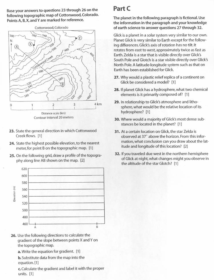
Baseyour answers to questions 23 through 26 on thefollowing topographic map of Cottonwood, Colorado.Points A, B,X,and Yare marked for reference.
580
2L
3L
4kmJ
Distance scale (km)
Contour interval 20 meters
23. State the general direction in which CottonwoodCreek flows. [1]
24. State the highest possible elevation, to the nearestmeter, for point Bon the topographic map. [1]
25. On the following grid, draw a profile of the topogra-phy along line ABshown on the map. [2]
A B
26. Use the following directions to calculate thegradient of the slope between points X and Yonthe topographic map.
a. Write the equation for gradient [1]
b. Substitute data from the map into theequation. [1]
c. Calculate the gradient and label it with the properunits. [1]
Part C
The planet in the following paragraph is fictional. Usethe information in the paragraph and your knowledgeof earth science to answer questions 27 through 32.
Glick is a planet in a solar system very similar to our own.Planet Glick is very similar to Earth except for the follow-ing differences. Glick's axis of rotation has no tilt Itrotates from east to west, approximately twice as fast asEarth. Zelda is a star that is visible directly over Glick'sSouth Pole and Glotch is a star visible directly over Glick'sNorth Pole. A latitude-longitude system such as that onEarth has been established for Glick.
27. Why would a plastic relief replica of a continent onGlick be considered a model? [1]
28. Ifplanet Glick has a hydrosphere, what two chemicalelements is it primarily composed of? [1]
29. In relationship to Glick's atmosphere and litho-sphere, what would be the relative location of itshydrosphere? [1]
30. Where would a majorityof Glick'smost dense sub-stances be located in the planet? [1]
31. Ata certain location on Glick,the star Zelda isobserved at 37" above the horizon.Fromthis infor-mation,what conclusion can you draw about the lat-itude and longitude ofthis location? [2]
32. Ifyou traveled due west in the northern hemisphereof Glickat night, what changes might you observe inthe altitude of the star Glotch? [1]
620
600
580
I 560co0.
540>Q)m
520
500
480
460
.