iberia parish - coastal protection and restoration...
TRANSCRIPT
PARISH FACT SHEET
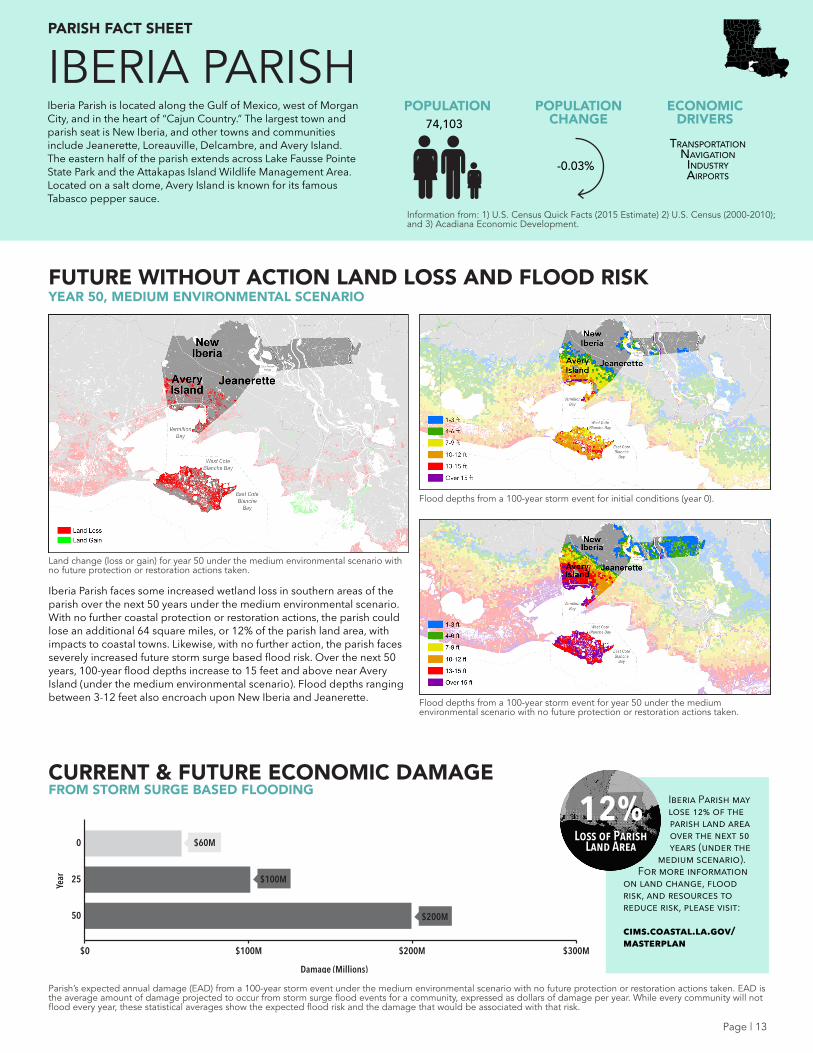
FUTURE WITHOUT ACTION LAND LOSS AND FLOOD RISK
CURRENT & FUTURE ECONOMIC DAMAGEFROM STORM SURGE BASED FLOODING
YEAR 50, MEDIUM ENVIRONMENTAL SCENARIO
ECONOMIC DRIVERS
POPULATION CHANGE
POPULATION
Parish’s expected annual damage (EAD) from a 100-year storm event under the medium environmental scenario with no future protection or restoration actions taken. EAD is the average amount of damage projected to occur from storm surge flood events for a community, expressed as dollars of damage per year. While every community will not flood every year, these statistical averages show the expected flood risk and the damage that would be associated with that risk.
Flood depths from a 100-year storm event for initial conditions (year 0).
Flood depths from a 100-year storm event for year 50 under the medium environmental scenario with no future protection or restoration actions taken.
Land change (loss or gain) for year 50 under the medium environmental scenario with no future protection or restoration actions taken.
IBERIA PARISH
Information from: 1) U.S. Census Quick Facts (2015 Estimate) 2) U.S. Census (2000-2010); and 3) Acadiana Economic Development.
$100M
$200M
$60M
IBE
$0
Year
$100M $300M$200M
Damage (Millions)
50
25
0
TransporTaTionnavigaTion
indusTryairporTs
-0.03%
74,103
Iberia Parish faces some increased wetland loss in southern areas of the parish over the next 50 years under the medium environmental scenario. With no further coastal protection or restoration actions, the parish could lose an additional 64 square miles, or 12% of the parish land area, with impacts to coastal towns. Likewise, with no further action, the parish faces severely increased future storm surge based flood risk. Over the next 50 years, 100-year flood depths increase to 15 feet and above near Avery Island (under the medium environmental scenario). Flood depths ranging between 3-12 feet also encroach upon New Iberia and Jeanerette.
Iberia Parish is located along the Gulf of Mexico, west of Morgan City, and in the heart of “Cajun Country.” The largest town and parish seat is New Iberia, and other towns and communities include Jeanerette, Loreauville, Delcambre, and Avery Island. The eastern half of the parish extends across Lake Fausse Pointe State Park and the Attakapas Island Wildlife Management Area. Located on a salt dome, Avery Island is known for its famous Tabasco pepper sauce.
12%Loss of Parish
Land Area
Iberia Parish may lose 12% of the parish land area over the next 50 years (under the
medium scenario). For more information
on land change, flood risk, and resources to reduce risk, please visit:
cims.coastal.la.gov/masterplan
Page | 13
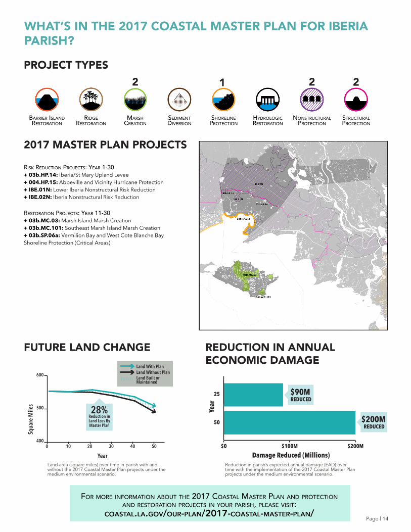
PROJECT TYPES
2017 MASTER PLAN PROJECTS
For more inFormaTion abouT The 2017 CoasTal masTer plan and proTeCTion and resToraTion projeCTs in your parish, please visiT:
coastal.la.gov/our-plan/2017-coastal-master-plan/
Land area (square miles) over time in parish with and without the 2017 Coastal Master Plan projects under the medium environmental scenario.
Reduction in parish’s expected annual damage (EAD) over time with the implementation of the 2017 Coastal Master Plan projects under the medium environmental scenario.
Barrier island restoration
shoreline Protection
sediment diversion
nonstructural Protection
hydrologicrestoration
structural Protection
marsh creation
ridge restoration
FUTURE LAND CHANGE REDUCTION IN ANNUAL ECONOMIC DAMAGE
2 22
WHAT’S IN THE 2017 COASTAL MASTER PLAN FOR IBERIA PARISH?
risk reduCTion projeCTs: year 1-30+ 03b.HP.14: Iberia/St Mary Upland Levee+ 004.HP.15: Abbeville and Vicinity Hurricane Protection+ IBE.01N: Lower Iberia Nonstructural Risk Reduction+ IBE.02N: Iberia Nonstructural Risk Reduction
resToraTion projeCTs: year 11-30+ 03b.MC.03: Marsh Island Marsh Creation+ 03b.MC.101: Southeast Marsh Island Marsh Creation+ 03b.SP.06a: Vermilion Bay and West Cote Blanche Bay Shoreline Protection (Critical Areas)
Year
Squa
re M
iles
100 20 30 40 50
600
500
400
28%Reduction in Land Loss By Master Plan
Land With PlanLand Without PlanLand Built orMaintained
Year
50
25 $90MREDUCED
$200MREDUCED
$0 $100M
Damage Reduced (Millions)$200M
1
Page | 14