idaho spring flood potential and weather briefing idaho department of water resources may 12, 2011...
TRANSCRIPT

Idaho Spring Flood Potential and Weather Briefing
Idaho Department of Water Resources
May 12, 2011Jay Breidenbach, NOAA National Weather Service
Snowpack Images
River Volume and Peak Flow Forecasts
Flood Potential
Short Term Weather Forecast
Short Term River Forecasts
30 and 60 day Climate Forecast
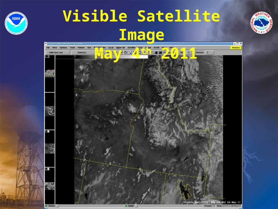
Visible Satellite Image May 4th 2011

Snow Water Equivalent May 10th, 2011 –This Year
Snow Water Equivalent May 10th, 2011 –This Year

Snow Water Equivalent May 10th, 2011
Snow Water Equivalent May 10th, 2011

Snow Water Equivalent May 10th, 2010 – Last Year
Snow Water Equivalent May 10th, 2010 – Last Year

Snow Water Equivalent May 10th, 2011
Snow Water Equivalent May 10th, 2011

Water Year PrecipitationBoise
Water Year PrecipitationBoise
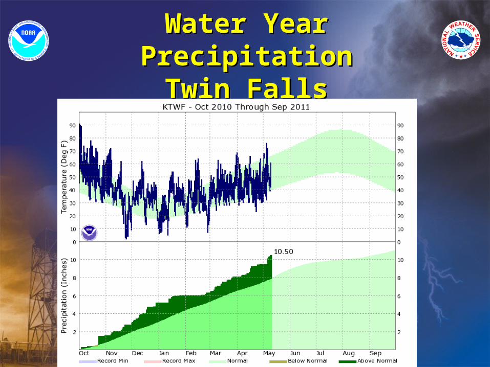
Water Year PrecipitationTwin Falls
Water Year PrecipitationTwin Falls

Wednesday - May 11th Satellite Image / Upper Flow Pattern
Wednesday - May 11th Satellite Image / Upper Flow Pattern

Wednesday, May 11th (Afternoon) Moisture / Afternoon TemperaturesWednesday, May 11th (Afternoon)
Moisture / Afternoon Temperatures

Thursday, May 12th (Afternoon) Moisture / Afternoon Temperatures
Thursday, May 12th (Afternoon) Moisture / Afternoon Temperatures
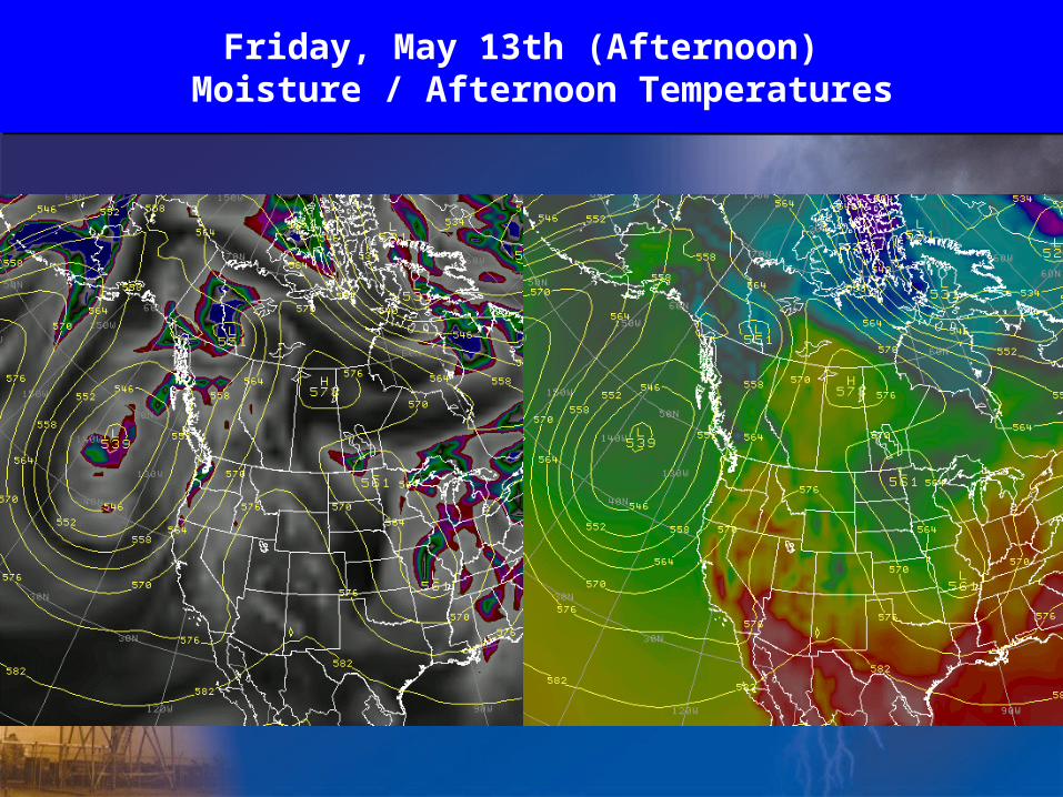
Friday, May 13th (Afternoon) Moisture / Afternoon Temperatures
Friday, May 13th (Afternoon) Moisture / Afternoon Temperatures

Saturday, May 14th (Afternoon) Moisture / Afternoon Temperatures
Saturday, May 14th (Afternoon) Moisture / Afternoon Temperatures

Sunday, May 15th (Afternoon) Moisture / Afternoon Temperatures
Sunday, May 15th (Afternoon) Moisture / Afternoon Temperatures

Monday, May 16th (Afternoon) Moisture / Afternoon Temperatures
Monday, May 16th (Afternoon) Moisture / Afternoon Temperatures

Tuesday, May 17th (Afternoon) Moisture / Afternoon Temperatures
Tuesday, May 17th (Afternoon) Moisture / Afternoon Temperatures

High Temperatures Saturday Monday
High Temperatures Saturday Monday
Temperature Precipitation
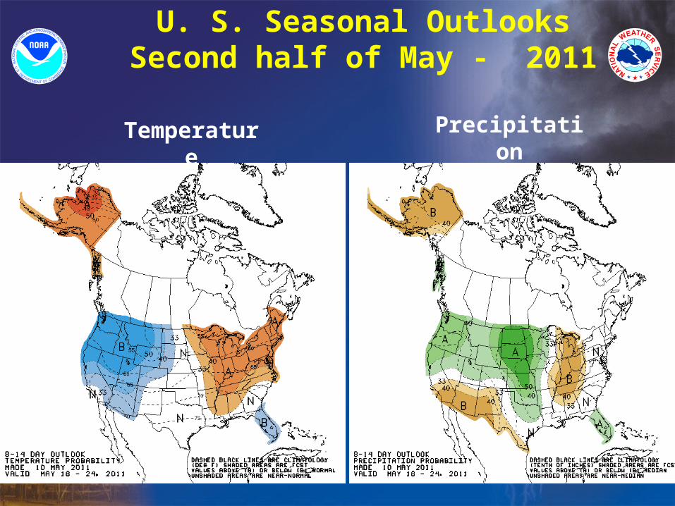
U. S. Seasonal OutlooksSecond half of May - 2011

Temperature Precipitation
U. S. Seasonal OutlooksMay – July 2011

Above Normal Water Volumes will be produced by all Idaho Streams in 2011Above Normal Water Volumes will be
produced by all Idaho Streams in 2011

Idaho Spring Flood Risk IncreasingIdaho Spring Flood Risk Increasing
Highlights:
Large snow pack and Forecast River Volumes have elevated flood risk in:
-Upper Snake River Basin including Henry’s Fork and Teton River
-Bear River Basin
-Bruneau River
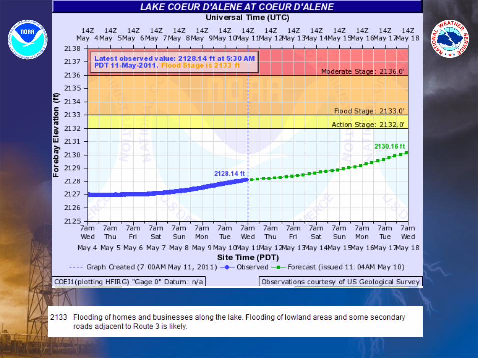
-Portions of Idaho Panhandle including Coeur D Alene, St Joe, Kootenia Rivers.
-Small Stream in upper Clearwater
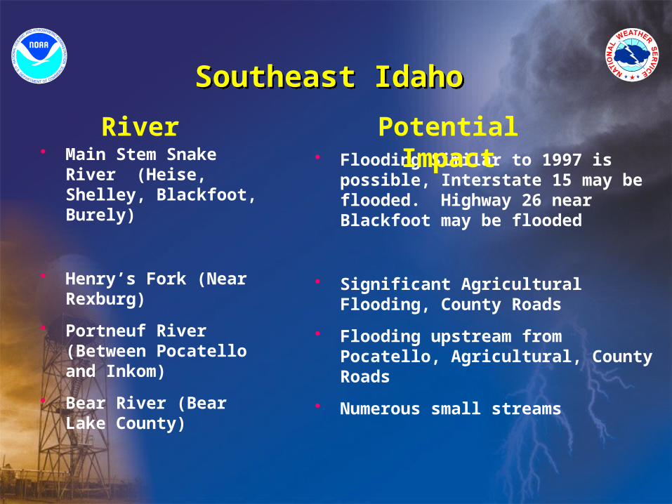
Southeast Idaho Southeast Idaho
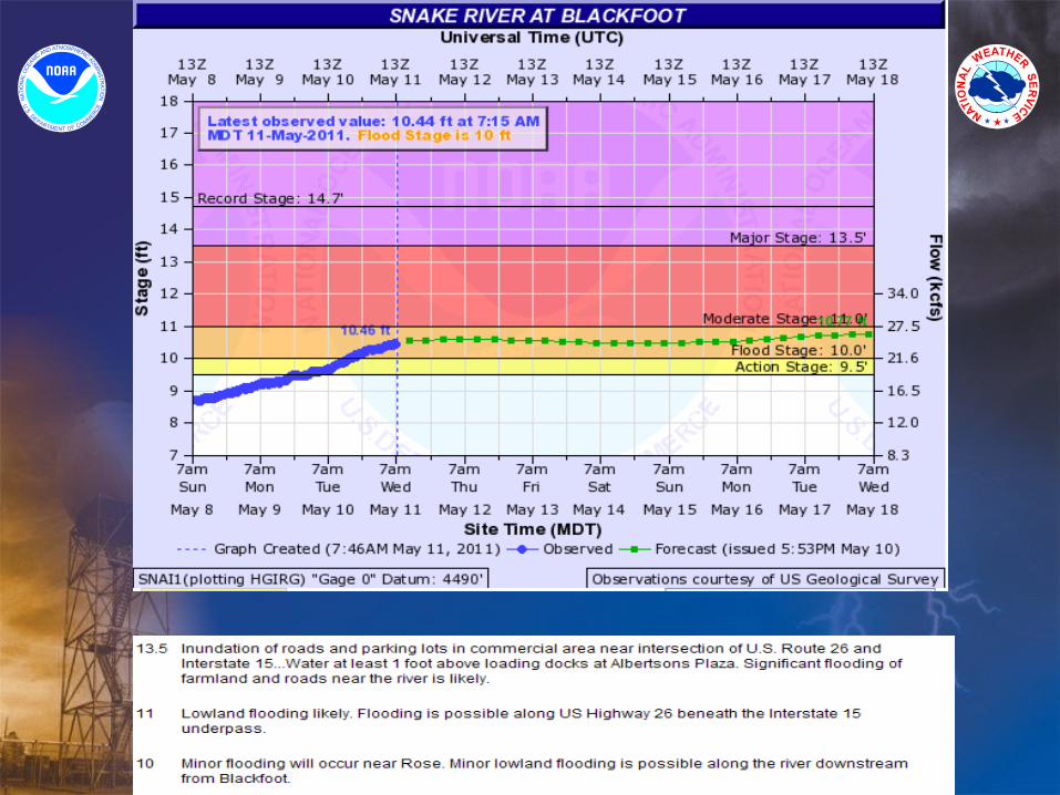
• Main Stem Snake River (Heise, Shelley, Blackfoot, Burely)
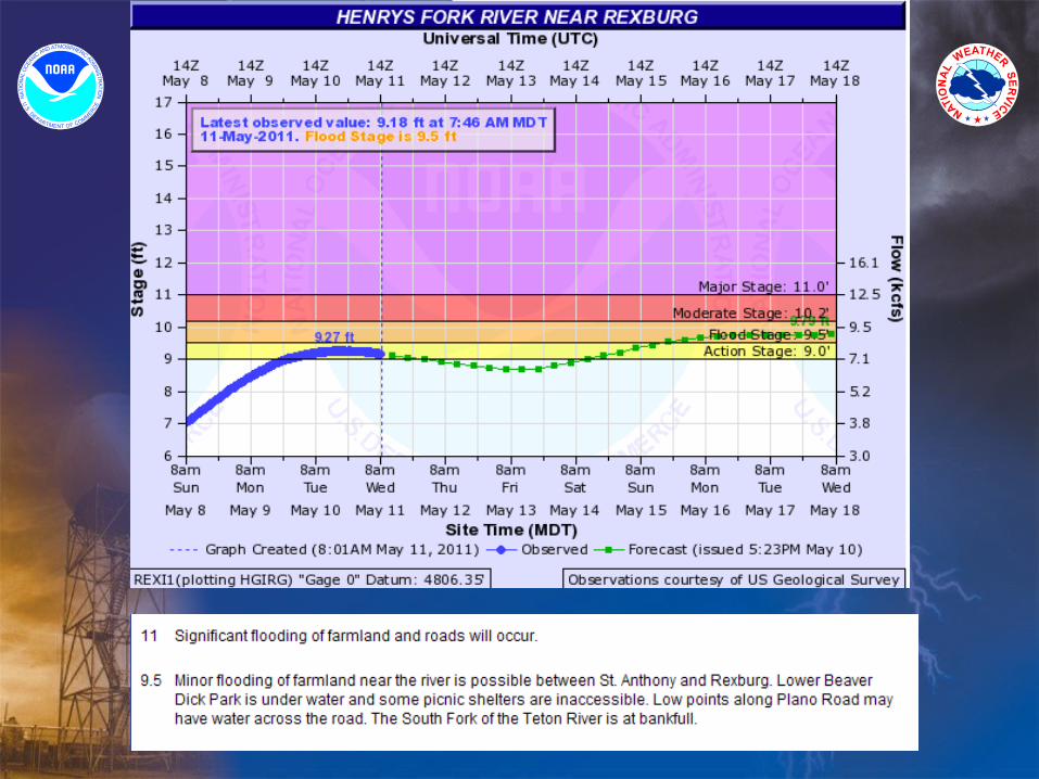
• Henry’s Fork (Near Rexburg)
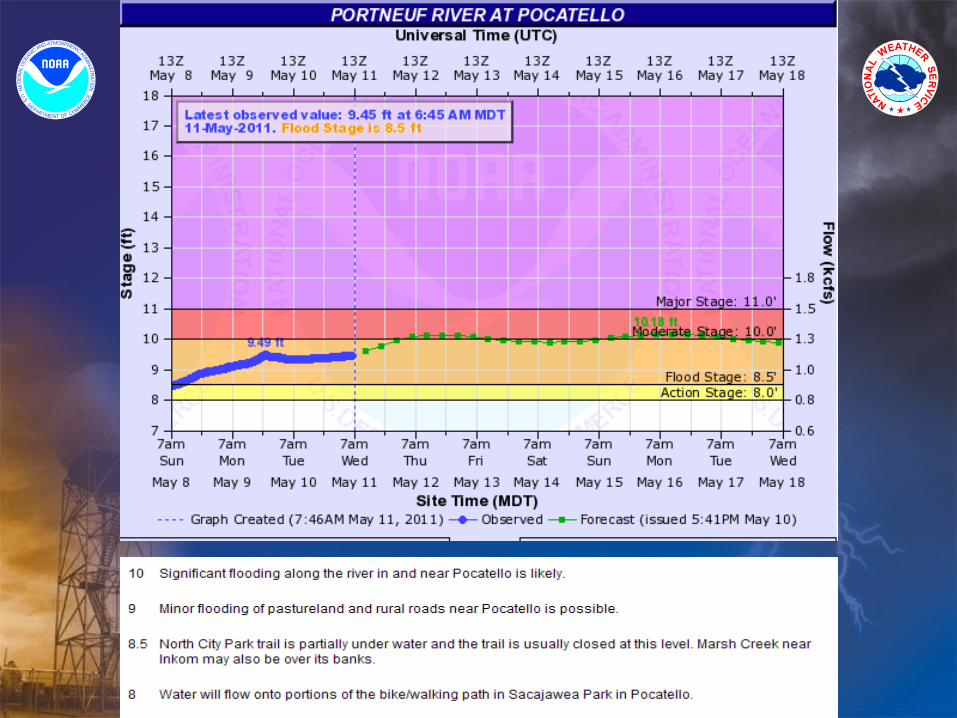
• Portneuf River (Between Pocatello and Inkom)
• Bear River (Bear Lake County)
River• Flooding Similar to 1997 is possible,
Interstate 15 may be flooded. Highway 26 near Blackfoot may be flooded
• Significant Agricultural Flooding, County Roads
• Flooding upstream from Pocatello, Agricultural, County Roads
• Numerous small streams
Potential Impact

Northern Idaho Northern Idaho
• Coeur d’ Alene River and tributaries
• St Joe River
• Northern Idaho Lakes
• Kootenai (Bonners Ferry)
• Moyie
River• Floodwaters surround homes in Cataldo
behind levee. Roads along NF Coeur d’ Alene River flood. Interstate access at Cataldo may flood.
• Flooding of county roads and low areas near the river
• Flooding of property along lake shores
• Significant Agricultural Flooding.
• Numerous home Impacted along river, especially just south of Canadian Border.
Potential Impact

Central and Southwest Idaho Central and Southwest Idaho
• Clearwater River and its Tributaries
• Payette River
• Boise River
• Small Streams
River• Clearwater river at Orofino has a 30 percent
chance of reaching flood stage. Numerous small streams will be susceptible to flooding
• Not expected to reach flood stage, but large rain event could cause flooding similar to what occurred in 2011 with flooding affecting Lowman, Emmett and Payette
• Flood control operations continue with high water affecting parkland in Boise, Garden City, Eagle, Caldwell.
• Isolated problems will occur on small streams but a repeat of 2011 small stream flooding not expected unless heavy rain occurs.
Potential Impact


QuestionsQuestions
www.weather.gov
www.weather.water.gov