iea pk tamnava west field
DESCRIPTION
IEATRANSCRIPT

JP ELEKTROPRIVREDA SRBIJE
RB „K O L U B A R A“ d.o.o.
OGRANAK P R O J E K T
ENVIRONMENTAL IMPACT ASSESSMENT STUDY FOR THE
PROJECT: ‘SUPPLEMENTARY MINING DESIGN – OCM TAMNAVA WEST FIELD’
Page 1 of 163
INVESTOR:
ELECTRIC POWER INDUSTRY OF SERBIA
MB "KOLUBARA’’ ltd
OPEN CAST MINES
BAROSEVAC
ENVIRONMENT IMPACT ASSESMENT STUDY OF THE PROJECT: "SUPPLEMENTARY MINING DESIGN "TAMNAVA WEST FIELD"

JP ELEKTROPRIVREDA SRBIJE
RB „K O L U B A R A“ d.o.o.
OGRANAK P R O J E K T
ENVIRONMENTAL IMPACT ASSESSMENT STUDY FOR THE
PROJECT: ‘SUPPLEMENTARY MINING DESIGN – OCM TAMNAVA WEST FIELD’
Page 2 of 163
Table of Contents
INTRODUCTION .............................................................................................................................................................. 5
METHODOLOGY ............................................................................................................................................................. 8
LEGAL REGULATIONS ..................................................................................................................................................... 9
1. EMPLOYER DATA...................................................................................................................................................... 15
2. DESCRIPTION OF THE WIDER LOCATION ON WHICH PROJECT IMPLEMENTATION IS PLANNED .......................... 15
2.1. ADJUSTMENT OF CHOSEN LOCATION WITH SPATIAL-PLANNING DOCUMENTS ....................................................................... 17 2.2 VICINITY OF THE AREAS PROTECTED BY INTERNATIONAL OR LOCAL REGULATIONS (PROTECTED GOODS: NATURAL, CULTURAL, AND
HISTORICAL) ................................................................................................................................................................. 18 2.3 VICINITY OF SANITARY PROTECTION, WATERCOURSES, AND WATER SUPPLY SOURCES ............................................................. 21 2.4 POPULATION OR LOCATION DEVELOPMENT ................................................................................................................... 25 2.5. NATURAL RECOURSES AT THE SUBJECT LOCATION, WITH SPECIAL OBSERVATION AT THE PRESENCE OF SWAMPS SURFACE OR GROUND
WATERS, FORESTS, AGRICULTURAL LAND, FISHING AND HUNTING AREAS, MINERAL RAW MATERIALS … ........................................... 30 2.6. LOCATIONS AFFECTED BY EARTHQUAKES, LAND SUBSIDENCE BY LANDSLIDES, EROSION, FLOOD, TEMPERATURE DIFFERENCES, COMMON FOGS, AND STRONG WINDS ............................................................................................................................... 32 2.7. PRESENCE OF HOSPITALS, SCHOOLS, KINDER GARDENS, RELIGIOUS BUILDINGS, PUBLIC FACILITIES AT THE LOCATION .................... 36 2.8. AREA ON OR NEAR LOCATION ON WHICH PROTECTED, IMPORTANT OR SENSITIVE PLANT AND ANIMAL SPECIES ARE USED .............. 37 2.9. VELOCITY OF IMPORTANT ROADS OR FACILITIES FOR PUBLIC ACCESS TO RECREATION CENTER AND OTHER FACILITIES.................... 37 2.10. FACILITIES FOR SMALL BUSINESS, TOURISM AND TRADE AT THE SUBJECT LOCATION AND ITS SURROUNDINGS ........................... 38 2.11. LAY-OUT PLAN – GRAPHICS..................................................................................................................................... 39
3. VIEW OF CURRENT ENVIRONMENT STATE (MICRO AND MACRO LOCATION) ...................................................... 39
3.1. WATERS (GROUND AND SURFACE) ............................................................................................................................. 40 3.1.1 Hydro-geology and ground water quality ................................................................................................... 40 3.1.2. Hydrology and quality of surface waters ................................................................................................... 45
3.2. SOIL CONDITION ..................................................................................................................................................... 50 3.3. AIR QUALITY .......................................................................................................................................................... 52 3.4. NOISE, ELECTROMAGNETIC RADIATION, LIGHT RADIATION ............................................................................................... 52 3.5. BUILDINGS OR FACILITIES, ON OR NEAR LOCATIONS, WHICH ALREADY HAVE CAUSED ENVIRONMENTAL POLLUTION...................... 53 3.6. THE STATE OF FLORA AND FAUNA............................................................................................................................... 54 3.7. LOCATION SETTLEMENT (URBAN OR RURAL) ................................................................................................................. 55 3.8. LEVEL OF LOCATION DEVELOPMENT (RATIO OF GREEN AREAS AND ALREADY EXISTING FACILITIES) ............................................ 55 3.9. CLIMATE FACTORS ANALYSIS OF THE LOCATION ............................................................................................................. 56 3.10. LOCATION ANALYSIS – ZERO STATE, FROM THE ENVIRONMENTAL PROTECTION ASPECT AND SUITABILITY OF SELECTED LOCATION FOR
PROJECT DEVELOPMENT .................................................................................................................................................. 56
4. PROJECT DESCRIPTION ........................................................................................................................................ 58
4.1 PHYSICAL CHARACTERISTICS DESCRIPTION (SIZE AND CAPACITY) AND LAND USE CONDITIONS DURING IMPLEMENTATION OF
WORKS AND REGULAR OPERATION, WITH OBSERVATION OF POSSIBLE PHYSICAL CHANGES OF TERRAIN ............................................ 58 4.1.1 Physical characteristics of the project – description ............................................................................... 58
4.1.1.1 Geographic location ............................................................................................................................................... 58 4.1.1.2 Morphological characteristics of the terrain ........................................................................................................ 59 4.1.1.3 Climate conditions................................................................................................................................................. 59 4.1.1.4. Hydrographical terrain characteristic .......................................................................................................................... 60 4.1.1.5. Deposit exploration ...................................................................................................................................................... 61
4.1.2. Description of terrains physical changes ................................................................................................... 68 4.1.2.1. Changing of visual identity of the area ........................................................................................................................ 68 4.1.2.2 Allocation and regulation of the river watercourses ................................................................................................... 68 4.1.2.3. Roads allocation and construction and other construction works............................................................................ 71
4.2. TECHNOLOGICAL PROCESS SUMMARY-PROJECT IMPLEMENTATION ................................................................................... 73 4.3. RAW MATERIALS AND PRODUCTS ............................................................................................................................... 81
JP ELEKTROPRIVREDA SRBIJE
RB „K O L U B A R A“ d.o.o.
OGRANAK P R O J E K T
ENVIRONMENTAL IMPACT ASSESSMENT STUDY FOR THE
PROJECT: ‘SUPPLEMENTARY MINING DESIGN – OCM TAMNAVA WEST FIELD’
Page 3 of 163
4.4. THE WAY OF NATURAL RECOURSES USAGE, ESPECIALLY NON-RENEWABLE ONES, OR HARDLY RENEWABLE (LAND, WATER, MINERAL
RAW MATERIALS, STONE, GRAVEL, SAND, FORESTS, POWER AND OTHER, WITH OBSERVATION ON POSSIBLE OCCUPATION OF THEIR AREAS
................................................................................................................................................................................. 83 4.5. ANALYSIS OF OTHER PROJECT FACTORS ON THE ENVIRONMENT, WITH OBSERVATION ON THE CUMULATIVE EFFECT WITH ALREADY
EXISTING OR PLANNED ACTIVITIES ON THE LOCATION, ANALYSIS ON POSSIBLE OR EXECUTED VIOLATION OF ENVIRONMENTAL STANDARDS
AT THE SUBJECT LOCATION .............................................................................................................................................. 83 4.6. IMPACTS, OF PRODUCTS OCCURRED DURING THE PROJECT, ON THE ENVIRONMENT .............................................................. 86 4.7. PROJECT IMPACT ON AVAILABILITY OR SUFFICIENCY OF NATURAL RECOURSES (FOSSIL FUELS, GROUND WATERS, MINERAL RAW
MATERIALS, STONE, SAND GRAVELS, FORESTS…) .................................................................................................................. 88 4.8. DIRECT PROJECT IMPACT ON HUMAN’S HEALTH ............................................................................................................ 88
5. THE OVERVIEW OF MAIN ALTERNATIVES CONSIDERED BY THE EMPLOYER ......................................................... 89
5.1 ALTERNATIVE LOCATION OR ROUTE ............................................................................................................................. 89 5.2. ALTERNATIVE TECHNOLOGICAL PROCEDURE ................................................................................................................. 89 5.3. MANAGING WITH WASTE SUBSTANCES CREATED DURING PROJECT IMPLEMENTATION........................................................... 90
6. DESCRIPTION OF POSSIBLE SIGNIFICANT PROJECT IMPACTS ON THE ENVIRONMENT AN PEOPLES HEALTH ...... 90
6.1. ANALYSIS ON DIRECT, INDIRECT, SECONDARY, CUMULATIVE, SHORT-MID-LONG TERM, CONSTANT, OCCASIONAL, TEMPORARY, AND
NEGATIVE ENVIRONMENTAL IMPACTS ................................................................................................................................ 90 6.2. IDENTIFICATION OF POSSIBLE POLLUTION CAUSES AND DEGRADATION ............................................................................... 91 6.3. IMPACT ANALYSIS ON GEOLOGY AND GEO MORPHOLOGY ................................................................................................ 93 6.4. IMPACT ANALYSIS ON AIR QUALITY ............................................................................................................................. 93 6.5. NOISE IMPACT ANALYSIS .......................................................................................................................................... 98 6.6. IMPACT ANALYSIS ON GROUND AND SURFACE WATER QUALITY....................................................................................... 100
6.6.1. Ground water quality ............................................................................................................................... 100 6.6.2. Surface water quality ............................................................................................................................... 101
6.7. ANALYSIS ON SOIL QUALITY CHANGE ......................................................................................................................... 102 6.8. IMPACT ANALYSIS ON FLORA, FAUNA AND ECO SYSTEMS ............................................................................................... 107 6.9. SOCIAL AND ECONOMIC IMPACT .............................................................................................................................. 108 6.10. CULTURAL HERITAGE IMPACT ANALYSIS ................................................................................................................... 109 6.11. IMPACT ANALYSIS ON PEOPLE HEALTH ..................................................................................................................... 109 6.12. OTHER RISKS AND THEIR SOURCES .......................................................................................................................... 110
7. ENVIRONMENTAL IMPACT ASEESMENT IN CASE OF ACCIDENT ........................................................................... 114
8. DESCRIPTION OF PERDICTED MEASURES IN ORDER OF INCREASEMENT AND WHERE IT IS POSSIBLE OF REMOVAL OF EACH MORE SIGNIFICANT HARMFUL EFFECT ON THE ENVIRONMENT ............................................. 123
8.1. MEASURES PREDICTED BY LAW AND OTHER REGULATIONS, NORMS, STANDARDS AND DEADLINES FOR THEIR IMPLEMENTATION .. 123 8.1.1. Conditions and compliances .................................................................................................................... 123 8.1.2. Measures during facilities construction ................................................................................................... 124 8.1.3. Measure during project regular operation .............................................................................................. 124
8.2. MEASURE TO BE IMPLEMENTED IN CASE OF HAZARDS................................................................................................... 125 8.2.1. Employees in case of hazards .................................................................................................................. 126
8.3. RECYCLING, TREATMENT AND WASTE SUBSTANCES DISPOSAL ......................................................................................... 128 8.4.1. Technical reclamation .............................................................................................................................. 131 8.4.2. Biological reclamation ............................................................................................................................. 131
8.5. OTHER MEASURES WHICH MAY AFFECT ON PREVENT OR REDUCE THE ENVIRONMENTAL HARMFUL IMPACT.............................. 132 8.5.1. Air protection ........................................................................................................................................... 132 8.5.2. Noise protection ....................................................................................................................................... 135 8.5.3. Ground and surface waters protection .................................................................................................... 135
8.5.3.1 Ground water protection ............................................................................................................................................ 136 8.5.3.2. Surface waters protection .......................................................................................................................................... 136
8.5.4. Visual identity of the subject area............................................................................................................ 137 8.5.5 Existing cultural heritage .......................................................................................................................... 138 8.5.6 Flora, fauna, and eco systems................................................................................................................... 138
JP ELEKTROPRIVREDA SRBIJE
RB „K O L U B A R A“ d.o.o.
OGRANAK P R O J E K T
ENVIRONMENTAL IMPACT ASSESSMENT STUDY FOR THE
PROJECT: ‘SUPPLEMENTARY MINING DESIGN – OCM TAMNAVA WEST FIELD’
Page 4 of 163
8.5.7 Social economic measures ........................................................................................................................ 139 8.5.8. Health protection ..................................................................................................................................... 139 8.5.9. Infrastructure and traffic ......................................................................................................................... 140 8.5.10 Other environmental protection measures ............................................................................................. 140
9. ENVIRONMENTAL IMPACT MONITORING PROGRAM .......................................................................................... 144
9.1. ENVIRONMENT STATE OVERVIEW BEFORE PROJECT START FUNCTIONING AT LOCATIONS WHERE ENVIRONMENTAL IMPACT IS
EXPECTED .................................................................................................................................................................. 145 9.2. PARAMETERS BASED ON WHICH HARMFUL ENVIRONMENTAL EFFECTS COULD BE ESTABLISHED .............................................. 145 9.3. POINTS, MANNER AND FREQUENCY OF ESTABLISHED MEASUREMENT PARAMETERS ............................................................ 146
9.3.1 Air quality monitoring ............................................................................................................................... 146 9.3.2. Noise monitoring...................................................................................................................................... 148 9.3.4. Land use and reclamation monitoring ..................................................................................................... 151 9.3.5. Control consideration and adoption of obtained results - "auditing" ...................................................... 152
10.NON-TECHNICAL SUMMARY DATA SPECIFIED IN 1-10 ........................................................................................ 156
11. DATA ON TECHNICAL DEFECTS OR NONEXISTANCE OF CERTAIN EXPERT SKILLS .............................................. 161
12. STUDY DEVELOPERS DATA................................................................................................................................... 161
13. LITERATURA ......................................................................................................................................................... 162
14. ANNEX .................................................................................................................................................................. 163

JP ELEKTROPRIVREDA SRBIJE
RB „K O L U B A R A“ d.o.o.
OGRANAK P R O J E K T
ENVIRONMENTAL IMPACT ASSESSMENT STUDY FOR THE
PROJECT: ‘SUPPLEMENTARY MINING DESIGN – OCM TAMNAVA WEST FIELD’
Page 5 of 163
INTRODUCTION
Commitment of Serbia for inclusion in the EU includes facing with new challenges in the way of environmental protection issues. In order to meet conditions more easily, economy, but also entire society, must finally become active partners within implementation of environmental protection policy. Together with the state administration, they must find the manner for introduction of the most appropriate tools, like economic encourages, introduction of ISO standard, establishing the system for environment managing or obtaining of integrated license. For that reason, one of the priorities must be frame development and opportunities for introduction of more cleaner and more sustainable practice of management in all social segments.
IPPC Directive (96/61 EC) is one of the first EU directives transposed into the legislation of the Republic of Serbia through:
Law on integrated pollution prevention control (official Gazette of the Republic of Serbia № 135/04) aimed at regulation harmonization from the field of environmental protection and by laws:
Rules on content and manner of records keeping of issued integrated licenses "Official Gazette RS ", № 69/05
Decree on types of activities for which integrated license is issued "Official Gazette RS №: 84/05.
Decree on criteria for determination of the best available techniques, for quality standard application, and for determination of limit values emissions in integrated license "Official Gazette RS №: 84/05
Decree on contents programme of measures for functioning of the existing facilities or activities by prescribed conditions "Official Gazette RS №: 84/05
Directive is defining measures providing integrated approach of pollution prevention control, aiming to the achievement of high preservation environmental level. It includes:
Rational managing of national resources in accordance with the principal "Polluter pays"
Action on the pollution sources of emission reduction in accordance with the emission limit values
Defining of emission limit values based on the application of BAT technology, considering technical characteristics of facilities, their location and environmental state near the facility
Process development of information exchange between EU countries, for the purpose of improvement and application of BAT
IPPC Directive is related to industrial sectors causing the biggest negative impacts on the environment, and placing integrated consideration of technological cycles and applied environmental protection measures. It implies to the fact that complex requests are valid for all industrial sector, in the field of applied production technologies, as well as in the field of environment protection.
Considering that appropriate regulation on integrated control and pollution prevention do not exist, Republic of Serbia adopted four new laws (Official Gazette of Republic of Serbia № 135/2004), harmonized with corresponding EU regulations. These laws are as follows:

JP ELEKTROPRIVREDA SRBIJE
RB „K O L U B A R A“ d.o.o.
OGRANAK P R O J E K T
ENVIRONMENTAL IMPACT ASSESSMENT STUDY FOR THE
PROJECT: ‘SUPPLEMENTARY MINING DESIGN – OCM TAMNAVA WEST FIELD’
Page 6 of 163
Environment Protection Law "Official Gazette RS № 135/04
Law of Integrated Prevention and Environment Pollution Control "Official Gazette RS ", № 66/91, 135/04
Law of Environment Impact Assessment "Official Gazette RS ", № 66/91, 135/04
Law of Strategic Impact Environment Assessment "Official Gazette RS №135/04
Environment Protection Law includes an integral environment protection system, which provides humans rights achievement on life and development within healthy environment, and balanced relations between economy and environment in Republic of Serbia. This law presents one step closer to resolving national regulations and EU regulations regarding environment protection. Main elements of EU regulations are included within that Law.
Law of Strategic Impact Environment Assessment is performed for plans, programs and baselines within field of spatial planning or land use, agriculture, forestry, fishery, energy, industry, traffic, telecommunications, tourism, infrastructural system, waste management, water management, - it is all included within plan, i.e., program or baseline. Strategic Environmental Impact Assessment must be harmonized with other environment impact assessments, as well as with environment plans and environment protection programs, and to be performed in accordance with procedure prescribed by law.
Law of Environment Impact Assessment suggests that environment impact assessment of the projects is performed for projects planed and implemented within space, including technologies, reconstruction, capacities extension or operation termination, which may cause serious environment pollution or health risk. Environment impact assessment includes projects related to the field of industry, mining, energy, traffic, tourism, agriculture, forestry, water management, as well as all projects planed to be implemented on nature’s asset and protected areas. Environment Impact Assessment is prevention management tool of environment protection, based on study development and consultations implemented with wide public precipitation, based on alternative solutions aimed at data collection and prediction of harmful impacts of certain projects on different recipients within environment; establishing and protection measures proposal by which harmful impacts could be prevented, reduced or removed, having in mind their feasibility. It is important to point out that engineer structure has environment impact assessment as its integral part, and it is part of technical documents without which project implementation could not be possible.
Law of Integrated Prevention and Environment Pollution Control defines:
Integrated license obtaining is condition for certain types of facilities operation
Integrated license is one decision under which conditions for discharge of pollution substances are established
New facilities for which integrated license is required must apply BAT in their operation
Existing facilities which do not apply BAT conditions in period request submission of license issuing, must submit program of measures for operation plan adjusted with prescribed conditions

JP ELEKTROPRIVREDA SRBIJE
RB „K O L U B A R A“ d.o.o.
OGRANAK P R O J E K T
ENVIRONMENTAL IMPACT ASSESSMENT STUDY FOR THE
PROJECT: ‘SUPPLEMENTARY MINING DESIGN – OCM TAMNAVA WEST FIELD’
Page 7 of 163
Authorized body can reconsidered (revision) an integrated license, especially in case of substantial BAT changes, or changes within regulation on environment protection
Authorized body for license issuing provides public precipitation in integrated license issuing procedure, as well as its revision
General long term objective of environment protection at the wider area of Kolubara lignite basin is to provide controlled conditions of lignite deposit excavation and electricity generation, and simultaneously, to reduce permanent area degradation and environment pollution. Special environment protection objectives includes following items:
Providing of conditions for preservation and rational use of natural recourses (water, coal reserves)
Prevention of dirty technologies transfer
Reduction of uncontrolled discharge of pollutants and toxic substances and further environment degradation
Reduction of waste amount, processing and waste recycling
Recovery of polluted environment parts and degraded areas
Preservation of natural eco systems and biodiversity
Establishing of sustainable development concept within process of strategic investment decisions making
Taking of system and permanent measures of protection, restitutions, and polluted environment rehabilitation
Taking of system and permanent measures of habitants protection affected by harmed environment state
Open Cast Mine Tamnava – West Field is the youngest mine of the Kolubara Mining Basin, designed for the production of 12 x 106 t of coal, i.e. 22 x 106 m3 of overburden. First mining activities were started in 1984 with the cutting of an opening – dewatering trench from the northern, i.e. north-western side of the mine. These works were done on the basis of the Detailed Design of Opening, Development and Mining of the Open Cast Mine Tamnava – West Field (1984). Removal of overburden was started in 1994 and coal mining in 1995. Overburden and coal excavation works were done on the basis of the Detailed Mining Design of the Open Cast Mine Tamnava – West Field (1993).
From the start of operations until mid-2007, some 135 x 106 m3 of overburden and 67 x 106 t of coal have been excavated, whereas some 4 x 10⁶ m3 of interburden have been selectively excavated and dumped.
In the course of further mining operations, due to the lack of harmonization of procurement of the necessary equipment from the Construction Investment Programme aimed at the achievement of the design capacity, the land acquisition issues, untimely construction of facilities for mine protection against water, other solutions have been employed which deviated from the previously designed ones. All new technical solutions were accompanied with the technical documents of the corresponding level, in accordance with the legal regulations.
Due the need to update the design documents from 2004, Supplementary Mining Design for OCM Tamnava – West Field was developed for the operation period between 2003 and 2007.

JP ELEKTROPRIVREDA SRBIJE
RB „K O L U B A R A“ d.o.o.
OGRANAK P R O J E K T
ENVIRONMENTAL IMPACT ASSESSMENT STUDY FOR THE
PROJECT: ‘SUPPLEMENTARY MINING DESIGN – OCM TAMNAVA WEST FIELD’
Page 8 of 163
This design does not include technical solutions adopted in the meantime for operation of the machinery from OCM Tamnava – East Field in the area of OCM Tamnava – West Field implemented by the end of 2004.
Untimely construction of facilities at Duboki Potok was executed for the purpose of protection against surface waters. For this reason, further advancement of overburden and coal mining face based on the Supplementary Mining Design for the validity period of this document did not have any practical value.
Owing to the expiry of the validity of the Supplementary Mining Design for OCM Tamnava – West Field from 2004, for the operation period from 2003 to 2007, as well as the finalisation of facilities at Duboki Potok, conditions were created for the development of the new Supplementary Mining Design of OCM Tamnava – West Field covering the period from 2008 to 2012.
This Supplementary Mining Design will in addition to the settlement of accompanying problems (e.g. land acquisition, construction of ancillary structures necessary for mine operation, timely resettlement of population, as well as construction of the entire accompanying infrastructure and areas for the special purpose facilities) define the basic excavation, transport and dumping equipment, its detailed operation method for the period of five years, and in conceptual terms by the end of OCM Tamnava – West Field operation life. One of the main tasks to be defined by this Supplementary Mining Design is the establishment of the mining face at OCM Tamnava – West Field along east – west direction and full width of the mine, since in the previous operation periods, due to high number of negative factors, there have been deviations from this concept, i.e. forced technological solutions were aimed at meeting the planned production and not the designed mine development.
The Employer was under obligation to develop the Environmental Impact Assessment Study for the subject design as an integral part of the technical documents necessary to obtain the operation permit in accordance with the current environmental regulations.
METHODOLOGY
Subject production at the planned location must be harmonized with requests from the field of environment protection as uniform methodological basis with clearly defined steps for these issues analysis.
Hierarchical arrangement of methodological steps is starting point for methodological approach, enabling respect of the established schedule of the steps, and creation of the base line for decision making. All performed conclusions from the previous phase representing an obligation and starting point of each following step.
A necessity for uniform order of data exchange between these processes is conditioned with the fact that, the results of one process are presenting enter parameters of the other and vice versa. It is important to underline that this schedule is not arbitrary, but strictly follows the logic of both analyses, as well as mutual influences. The second important fact is related to the multidimensional harmonization of these data, for the needs of the process itself, as well as for the needs of informational basis for creation of greater importance.
Specificity of conditions related to the subject study are reflected in fact that it operates aiming to explore physical characteristics of the facilities in relation to the soil, on which was project planned to be implemented, and to define every characteristic of possible negative effect, as well as protection measures.
In the way of specified facts, applied exploration methodology of environmental issues is, according to its hierarchical arrangement and contents, verified manner of finding documented information.
Specific quality of subject project and characteristics of technological process of production, as well as specific qualities of environment existing state at the subject location, have conditioned applied

JP ELEKTROPRIVREDA SRBIJE
RB „K O L U B A R A“ d.o.o.
OGRANAK P R O J E K T
ENVIRONMENTAL IMPACT ASSESSMENT STUDY FOR THE
PROJECT: ‘SUPPLEMENTARY MINING DESIGN – OCM TAMNAVA WEST FIELD’
Page 9 of 163
methodology to be modified in certain manner, and to be harmonized with basic characteristics of design project and technological process of production.
An important part of investigation must be dedicated to quantification and evaluation of the current state.
The result of these analyses was the confirmation on the current environmental state at the subject location.
Considering that through the existing state analysis was established that, certain risks are existing in the way of environmental effects, second part of investigation is related to the indicators of possible effects, and potential threatening for the environment. From each harmful effect, those effects for which was proven that within spatial conditions defined mutual relation of planned activity and environment, have been analyzed in detail.
Successful solution in the field of environment protection implies to the round consideration and defining of all categories of specified effects. In this sense, always as the priority, we set an obligation on their defining compared with basic natural parameters. Basic natural factors include: climate, water, air, soil, flora, fauna, landscape, and all together they are representing completely regulated mechanism.
Processes inside elements of this complex system, are in progress based on depending of one another, organic or inorganic elements, where each facility and technological process with its special characteristics in some circumstances could lead to disorder relations.
Modifications occur from completely insignificant, to drastic in the manner that some elements could lose their basic characteristics.
System approach to the relations through criteria analysis in most cases is giving satisfying results, but only in case of their objective quantification process and respect between relations in a consistent manner.
Within this study research, recognizing each specific activity by which analyzed planned activity is being characterized, all special locations and characteristics of existing potentials, basic criteria have been considered, which through quantification procedures have been brought to the certain indicators with basic purpose for existing relations to be quantified and for their actual nature to be defined. Based on real indicators it could be possible to perform selection of adequate environmental protection measures, by which basic purpose of this study could be fulfilled.
At the final phase, and based on verified indicators, possibilities of environmental improvement and environmental protection measures are being investigated, and appropriate measures were suggested having justification in sense of rational negative impacts reduction.
On that occasion, obligations about to come from implementation of Design Draft Law on waste management, Draft Law on protection from non-ionizing radiation and Law on air protection, have been considered.
LEGAL REGULATIONS
Regulations and applicable law:
Ratified International Contracts significant for Republic of Serbia Legal regulations and by-laws
Regulations from other areas applicable in the field of environmental protection
Ratified International Contracts significant for Republic of Serbia 1. Law on confirmation of Convention on biological diversity (Official Gazette FRS- International Contracts", № 11/01)

JP ELEKTROPRIVREDA SRBIJE
RB „K O L U B A R A“ d.o.o.
OGRANAK P R O J E K T
ENVIRONMENTAL IMPACT ASSESSMENT STUDY FOR THE
PROJECT: ‘SUPPLEMENTARY MINING DESIGN – OCM TAMNAVA WEST FIELD’
Page 10 of 163
2. Law on ratification of Basel Convention on cross border movement of hazard waste material and its disposal ("Official Gazette FRS- International Contracts", № 2/99)
3. Law on ratification of Framework Convention of the United Nations on climate change, with annexes
("Official Gazette FRS- International Contracts", № 2/97)
4. Montreal Protocol on substances damaging ozone layer ("Official Gazette SFRY- International Contracts", № 16/90)
5. Vienna Convention on ozone layer protection, with appendix I and II ("Official Gazette SFRY- International Contracts", № 1/90)
6. International Convention for bird protection ("Official Gazette SFRY № 6/73)
7. Montreal Amendment on Vienna Convention on substances damaging ozone layer ("Official Gazette SCG- International Contracts", № 2/2004)
8. Law on ratification of Convention for protection of world cultural and natural heritage ("Official Gazette SFRY- International Contracts, № 8/74)
9. Law on ratification of Convention for protection of cultural heritage in case of armed conflict ("Official Gazette SFRY- International Contracts, № 4/56)
10. Law on ratification of Convention on cross border air pollution on great distances
("Official Gazette SFRY- International Contracts", №.11/86)
11. Law on ratification of Convention on cross border air pollution on great distances on long term financing of Cooperation program for monitoring and evaluation of cross border transmission of air pollution substances on great distances in Europe ("Official Gazette SFRY- International Contracts", №.2/87)
12. Law on ratification of Montreal protocol on substances damaging ozone layer ("Official Gazette SFRY- International Contracts", № 16/90)
13. Decree on ratification of Convention on benzole poisoning protection ("Official Gazette SFRY- International Contracts", № 16/76)
14. Law on ratification of Convention on prevention and inspection of professional risks caused by carcinogen substances and agents ("Official Gazette SFRY- International Contracts", № 3/77)
15. Law on ratification of Convention for protection of workers from professional risks in working environment, caused by air pollution, noise and vibration ("Official Gazette SFRY- International Contracts", №.14/82)
16. Law on ratification of Convention on health and safety in working environment
("Official Gazette SFRY- International Contracts", №.7/87)
17. Law on ratification of Convention on safety during utilization of asbestos ("Official Gazette SFRY- International Contracts", №.... 4/89)
18. Law on ratification of European Convention for protection of archaeological heritage ("Official Gazette SFRY- International Contracts", №.9/90)
19. Law on ratification of European Convention for protection of architectural treasure ("Official Gazette SFRY- International Contracts", №.4/91)
20. Law on confirmation of Agreement between Federal Government of the Federal Republic of Yugoslavia and Russian Federation on cooperation in the field of environmental improvement ("Official Gazette SFRY- International Contracts", №.6/96)
21. Law on confirmation of Belorussian Amendment of Annex B of Kyoto Protocol with Framework Convention of the United Nations on climate change ("Official Gazette RS- International Contracts", №.38/09)

JP ELEKTROPRIVREDA SRBIJE
RB „K O L U B A R A“ d.o.o.
OGRANAK P R O J E K T
ENVIRONMENTAL IMPACT ASSESSMENT STUDY FOR THE
PROJECT: ‘SUPPLEMENTARY MINING DESIGN – OCM TAMNAVA WEST FIELD’
Page 11 of 163
22. Law on confirmation of Convention on information availability, public participation in decision making processes, and, legal protection within environmental issues ("Official Gazette RS- International Contracts", №.38/09)
23. Law on confirmation of Rotterdam Convention on compliance approval procedure based on previous notification for certain hazardous chemicals and pesticides within international trade with amendments and additions ("Official Gazette RS- International Contracts", №.38/09)
Leal regulations and By-laws
1. Constitution of the Republic of Serbia ("Official Gazette RS №.83/06)
2. Environment Protection Law ("Official Gazette RS № 135/04, 36/9)
3. Law on strategic impact assessment ("Official Gazette RS № 135/04)
4. Law of Integrated Prevention and Environment Pollution Control ("Official Gazette RS ", № 66/91, 135/04)
5. Law of Environment Impact Assessment ("Official Gazette RS ", № 66/91, 135/04, 36/09)
6. Decree on kinds of activities and facilities for which integrated permit is issued ("Official Gazette RS ", № 84/05)
7. Decree on program for measures of adjustments for existing facility operation or activities prescribed by conditions ("Official Gazette RS ", № 84/05)
8. Rules on protection measures from natural disasters and other bigger disasters which must be part of technical documents for investment facilities construction ("Official Gazette RS ", № 34/78)
9. Decree on pollution types, criteria for fee calculation for environmental pollution, level and manner of calculation and fee payment ("Official Gazette RS ", № 113/2005)
10. Decree on establishing List of Projects for which is necessary to have impact assessment and list of projects for which impact assessment could be requested ("Official Gazette RS ", № 114/08)
11. Rules on conditions and criteria for development of impact analysis of facilities and activities on the environment ("Official Gazette RS ", № 49/01)
12 Rules on categorization of protected natural goods ("Official Gazette RS №: 30/92)
13. Rules on register of protected nature's facilities (“Official Gazette RS ", №: 30/92)
14. Rules on content of requests for necessity of assessment impact and content of requests for scope determination and content of Environment Impact Assessment Study (“Official Gazette RS №: 69/05)
15. Rules on content of Environment Impact Assessment Study ("Official Gazette RS ", №: 69/05)
16. Rules on content, scope and manner of development of the previous feasibility study for construction of facilities ("Official Gazette RS ", №:80/05)
17. Rules on functioning of technical committee for evaluation of Environment Impact Assessment Study ("Official Gazette RS ", №: 69/05)
18. Rules on content and manner of records keeping about executed procedures and decisions made on Environment Impact Assessment ("Official Gazette RS ", №: 69/05)
19. Rules on public inspection procedure, presentation and public discussion on Environment Impact Assessment Study ("Official Gazette RS ", №: 69/05)
20. Rules on content and manner of records keeping of issued integrated licenses ("Official Gazette RS ", № 69/05)
21. Rules on methodology for assessment of danger from chemical hazards, from environment pollution, preoperational measures and measures for consequence removal ("Official Gazette RS ", № 60/94 )
22. Rules on register of protected nature's facilities (“Official Gazette RS ", №: 30/92)

JP ELEKTROPRIVREDA SRBIJE
RB „K O L U B A R A“ d.o.o.
OGRANAK P R O J E K T
ENVIRONMENTAL IMPACT ASSESSMENT STUDY FOR THE
PROJECT: ‘SUPPLEMENTARY MINING DESIGN – OCM TAMNAVA WEST FIELD’
Page 12 of 163
Air Protection
1. Law on air protection (“Official Gazette RS ", №: 36/09)
2. Decree on criteria for determination of the best available techniques, for quality standard application, and for determination of limit values emissions in integrated license ("Official Gazette RS №: 84/05)
3. Rules on Emission Limit Values, Manner and Terms of Measurement and Recording of Information ("Official Gazette RS ", №: 54/92, 30/99)
4. Rules on the manner and deadline for reports submission on performed air pollution measurements ("Official Gazette FRS №: 27/73)
5. Rules on Emission Limit Values, Manner and Terms of Measurement and Recording of Information ("Official Gazette RS ", №: 30/97, 35/97)
6. Rules on closer conditions which have to be me by expert organizations which performing emissions and imission measuring ("Official Gazette RS ", №: 5/02)
Water protection
1. Water regime law ("Official Gazette FRY", №: 59/98)
2. Water Law ("Official Gazette RS", №: 46/91, 53/93, 67/93, 48/94, 54/96)
3. Law on usage and protection of water supply sources ("Official Gazette SRS", №: 27/77, 29/88)
4. Decree on water course categorization ("Official Gazette SRS", №: 5/68)
5. Decree on water management master plan establishing of Republic of Serbia ("Official Gazette RS", №: 11/02)
6. Decree on establishing of program for water quality system examination ("Official Gazette RS", №: 8/00)
7. Rules on manner of defining and zones of sanitary protection of the facilities for potable water supplying ("Official Gazette SRS", №:33/78)
8. Rules on hazardous substances in water ("Official Gazette SRS", №:31/82)
9. Rules on conditions which have to be met by enterprises and other legal entity which executing determination of surface, ground and waste water quality ("Official Gazette RS", №:41/94, 47/94)
10. Decree on categorization of watercourses ("Official Gazette RS №5/68)
11. Decree on classification of watercourses ("Official Gazette RS №5/68)
12. Rules on potable water hygiene ("Official Gazette FRY №42/98, 44/09)
13. Rules on Manner and minimum examination number of waste water quality ("Official Gazette SRS №47/C3, 13/84)
14. Rules on hazardous substances in water ("Official Gazette RS №31/82)
15. Order on fees for used water, for extracted material from river beds, from water courses banks, and for discharged contaminated water ("Official Gazette RS №9/91, 14/91, 29/91, 61/91)
16. Instruction on manner and procedure for establishing achieved treatment level of discharged waste water ("Official Gazette SRS №9/67)
17. Plan on water protection from contamination ("Official Gazette RS №6/91)
Soil protection
1. Law on agricultural land ("Official Gazette RS №62/06, 53/93, 67/93, 48/94, 46/95, 54/96, 14/00)
JP ELEKTROPRIVREDA SRBIJE
RB „K O L U B A R A“ d.o.o.
OGRANAK P R O J E K T
ENVIRONMENTAL IMPACT ASSESSMENT STUDY FOR THE
PROJECT: ‘SUPPLEMENTARY MINING DESIGN – OCM TAMNAVA WEST FIELD’
Page 13 of 163
2. Rules on permitted quantity of hazardous and harmful substances in ground and water for irrigation and methods for their testing ("Official Gazette RS №23/94)
Waste management
1. Waste management law ("Official Gazette RS №36/09)
2. Decree on waste oils management ("Official Gazette RS №60/08)
3. Decree on manner and procedures of waste management containing asbestos ("Official Gazette RS №60/08)
4. Rules on documents submitted with request for issuing of import license, export and waste transit ("Official Gazette FRY №69/99)
5. Rules on criteria for determination of the location and for development of hazard substances stockpile ("Official Gazette RS ", №: 54/92)
6. Rules on manner of treatment with waste which have hazardous substances characteristics ("Official Gazette RS ", №: 12/95)
7. Rules on conditions and manner of selection, packaging and storage of secondary raw materials ("Official Gazette RS №55/01)
Hazardous substances management
1. Rules on hazardous substances transport ("Official Gazette SFRY №27/90, 45/90," Official Gazette № FRY № 24/94, 28/96, 21/99)
2. Law on explosive substances placement ("Official Gazette SFRY №30/85, 6/89, 53/91," Official Gazette № FRY № 24/94)
3. Law on production and placement of poison substances ("Official Gazette № FRY № 15/95, 28/96)
4. Law on explosive substances, combustible fluids and gases ("Official Gazette № SRS № 44/77, 45/85, 18/89, "Official Gazette RS № 36/09)
5. Law on chemicals ("Official Gazette RS № 36/09)
6. Law on package and packing waste ("Official Gazette RS № 36/09)
7. Rules on hazard substances transport in road and rail way traffic ("Official Gazette RS ", №: 53/02)
8. Rules on manner of destroying unused poison and packing which is used for poison packing and the manner of withdrawal of poison from placement ("Official Gazette SFRY № 7/83)
9. Rules on construction of the liquid oil gas facility and on storage and decanting of liquid oil gas ("Official Gazette SFRY № 24/71)
10. Rules on construction of flammable liquid facilities and on storage and flammable liquids decanting ("Official Gazette SFRY № 20/71)
11. Rules on construction of station for motor vehicle fuel supplying and on storage and fuel decanting ("Official Gazette SFRY № 27/71)
12. Rules on manner of acting with waste which have hazardous substances characteristics ("Official Gazette RS № 12/95)
13. Decision on poison marking within placement ("Official Gazette FRY № 38/97)
14. List of poison classified into groups ("Official Gazette RS № 9/08)

JP ELEKTROPRIVREDA SRBIJE
RB „K O L U B A R A“ d.o.o.
OGRANAK P R O J E K T
ENVIRONMENTAL IMPACT ASSESSMENT STUDY FOR THE
PROJECT: ‘SUPPLEMENTARY MINING DESIGN – OCM TAMNAVA WEST FIELD’
Page 14 of 163
Fire protection
1. Fire protection law ("Official Gazette SRS №37 /88, and “Official Gazette RS № 53/93, 67/93, 48/94)
2. Decree on criteria for classification of organizations and bodies into appropriate fire risks categories ("Official Gazette SRS №58/89)
Protection from ionized and non-ionized radiation
1. Law on protection from ionized radiation and nuclear safety (“Official Gazette RS № 36/09)
2. Law on protection from non-ionized radiation ("Official Gazette RS № 36/09)
3. Rules on limits for exposure to ionized radiation ("Official Gazette SFRY №: 31/98, 63/89)
4. Rules on limits of ionized radiation exposure ("Official Gazette FRY №: 32/98)
5. Decision on qualifications and health conditions of persons who work with ionized radiation sources ("Official Gazette FRY №: 45/97)
6. Decision on recording ionized radiation sources and on radiation of the population, patients, and persons which are exposed to the radiation during work ("Official Gazette FRY №: 45/97)
Biodiversity
1. Law on plants protection ("Official Gazette RS №: 24/98, 26/98)
2. Law on plants protection from diseases and pests ("Official Gazette SRS №: 14/84, 6/89, and ("Official Gazette RS №:53/93, 67/93, 48/94)
3. Fisheries law Gazette RS №:35/94)
4. Law on protection of kinds of agricultural and woodland plants ("Official Gazette FRY №:28/00)
5. Law on nature preservation ("Official Gazette RS № 36/09)
6. Law on sustainable usage of fish stock ("Official Gazette RS № 36/09)
7. Decree on natural rarities protection ("Official Gazette RS № 50/93, 93/93)
8. Rules on manner destroying of plants for which destroying measures are ordered ("Official Gazette FRY №: 67/2001)
9. Resolution on policy of biodiversity sustainability in FRY ("Official Gazette FRY №: 22/94)
Noise protection
1. Law on noise protection in living environment ("Official Gazette RS № 36/09)
2. Law on permitted noise level in living environment ("Official Gazette RS № 54/92)
3. Decision on defining of organizations fulfilling conditions for noise measurement in living environment ("Official Gazette RS № 1/84, 44/84, 44/87, 51/97)
Miscellaneous
1. Mining Law ("Official Gazette RS № 44/95, 34/06)
2. Law on Health and Safety ("Official Gazette RS № 101/05)
3. Law on payment and direction of funds for usage of general interest within electricity generation and oil and gas production ("Official Gazette RS № 16/90)

JP ELEKTROPRIVREDA SRBIJE
RB „K O L U B A R A“ d.o.o.
OGRANAK P R O J E K T
ENVIRONMENTAL IMPACT ASSESSMENT STUDY FOR THE
PROJECT: ‘SUPPLEMENTARY MINING DESIGN – OCM TAMNAVA WEST FIELD’
Page 15 of 163
4. Law on hydrometeor logical activities of interest for the entire country ("Official Gazette SFRY № 18/88, 63/90)
5. Energy Law ("Official Gazette RS № 84/2004)
6. Forestry Law ("Official Gazette RS № 46/91, 83/92, 54/93, 67/93, 48/94, 54/96)
7. Law on natural and other bigger disasters protection ("Official Gazette SRS № 20/77, 24/85, 27/85, 6/89, 52/89 and "Official Gazette RS № 53/93, 67/93, 48/94)
8. Law on planning and construction ("Official Gazette RS № 47/2003)
9. Law on spatial planning of the Republic of Serbia ("Official Gazette RS № 13/96)
10. Law on standardization ("Official Gazette RS № 36/09)
11. Law on national parks ("Official Gazette RS № 39/93, 44/93, 53/93, 67/93, 48/94)
12. Law on hunting ("Official Gazette RS № 39/93)
13. Land acquisition law ("Official Gazette RS № 53/95)
14. Law on cultural assets ("Official Gazette RS № 71/94)
15. Public Procurement Law ("Official Gazette RS № 116/08)
1. EMPLOYER DATA
FULL NAME: CORPORATE ENTERPRISE MINING BASIN "KOLUBARA" d.o.o LAZAREVAC
PLACE: Lazarevac
ADRESS: Svetog Save №1
PHONE NUMBER (MANAGER): +381/11/8123-210
E-mail: [email protected]
Web site: www.rbkolubara.rs
MANAGER: Vladan Jovcic, B.Eng
REGISTRATION: Registered with Agency for Commercial Registers of Republic of Serbia, register number 2021
ID NUMBER: 07788053; TIN: 101138490
FOUNDER: PE" Electric Power Industry of Serbia"
ACTIVITY: lignite opencast mining and processing (cleaning, drying, crushing), stone extracting for civil engineering, limestone extraction, raw gypsum and chalk, gravel and sands extraction, clay and kaolin extraction, extraction of quartz sands and other ore.
OWNERSHIP STRUCTURE: 100% owned by the Republic of Serbia
2. DESCRIPTION OF THE WIDER LOCATION ON WHICH PROJECT IMPLEMENTATION IS PLANNED
Mining Basin" Kolubara" is created by settling and carbonization of plant masses in swamps and lakes of tertiary. It is situated 50 km in south-east direction from Belgrade (from 19˚53' to 20˚30' east from Greenwich, and 44˚39' to 44˚45' north longitude, figure 1). It covers areas of municipalities Lazarevac, Lajkovac, Ub, and Koceljeva, as well as the smaller parts of municipalities of Arandjelovac, Barajevo and Obrenovac, with total area, approximately, about 600km2, of which areas with investigated geological coal reserves have only 167km2.
This area is characterized with lowland and slightly inundated terrains around river Kolubara, Tamnava, Pestan, and Turija. It belongs to Kolubara basin which includes wide area between Valjevo Mountains

JP ELEKTROPRIVREDA SRBIJE
RB „K O L U B A R A“ d.o.o.
OGRANAK P R O J E K T
ENVIRONMENTAL IMPACT ASSESSMENT STUDY FOR THE
PROJECT: ‘SUPPLEMENTARY MINING DESIGN – OCM TAMNAVA WEST FIELD’
Page 16 of 163
and Rudnik at sought, Sumadija mountains at east, Sava River at north Cer and Vlasic at west. It has the shape of quadrilateral, having width 75-80 km, and length of approximately 60km.
Kolubara River divides basin in two parts with its midstream, east and west. In east part there are active open cast mines field "B" and "D", mined out field "A" and perspective fields, that is future open cast mines: field "C", "E","G", "F", Sopici and Veliki Crljeni. In west part of basin there are "Tamnava- East Field" mined out open cast mine, and "Tamnava West Field" an active open cast mine as well as perspective mine "Radljevo".
Figure1-Layout geographical map of part of the Serbia with Kolubara Mining Basin
"Tamnava West Field" belongs to its west part, with area of 21 km2. From west and south, mine boundaries have been established by artificial boundaries, and have borders with exploration field "Radljevo", at the east with OCM "Tamnava-East Field", while towards north; its natural boundary is coal seam thinning out (figure 2).
Figure 2-Layout map of Kolubara Mining Basin

JP ELEKTROPRIVREDA SRBIJE
RB „K O L U B A R A“ d.o.o.
OGRANAK P R O J E K T
ENVIRONMENTAL IMPACT ASSESSMENT STUDY FOR THE
PROJECT: ‘SUPPLEMENTARY MINING DESIGN – OCM TAMNAVA WEST FIELD’
Page 17 of 163
Towards north, field has established boundaries by line Stepojevac-Brgule-Sarbane, which, at the same time represents the spreading boundary of productive part of mining basin. Boundaries establishing towards west and south is not completely defined in geological way, an artificial boundary is adopted, defined by line Radljevo-Stublenica. Towards south-west, field has established boundaries by line Stublenica-Paljuvi-Skobalj-Vreoci that is, toward south by left lowland side of Vranicina River. Towards east, field spreading is also defined by artificial boundary, by line Skobalj-Mali Borak-Stepojevac.
Deposit is situated at the area of municipalities of Lajkovac and Ub, in the area of Kalenic Mali Borak, Radljevo, and Skobalj, that is on the pages:7D29 Stepojevac (32, 33, 42, 43, 52, 53, 62, 63, 72, 73, 82, 83). A copy of the plan is given within Annex of Study.
Within Kolubara basin "Tamnava West Field" includes area between profile lines:
"OE" (u -436500) in the west
"RO" (u-439500) in the east
"100" (x-922000) in the sought and
"172, 5" (x-929250) in the north
Deposit is characterized by good transport conditions and communication connections. Near the deposit thoroughfares are located: Belgade-Cacak-Podgorica, Belgrade-Celije-Valjevo-Zvornik, regional roads Lazarevac-Arandjelovac-Kragujevac and Valjevo-Ub-Obrenovac, as well as the railway with standard gauge Belgrade-Bar. In its close surroundings there is electrified industrial gauge Vreoci-Veliki Crljeni-Obrenovac. Simultaneously, the entire area is crossed with lower level roads, and in its middle macadam road Lajkovac-Obrenovac is passing, which goes by route of old railway with narrow gauge.
2.1. Adjustment of chosen location with spatial-planning documents
In the way of defining of base lines for investigation of environmental protection issues, it is necessary to collect and consider the existing designed documents which cover wider investigation area, for the purpose of making connection between this study investigation and conditions created by those documents.
For Kolubara Mining Basin higher level of the spatial-planning document is Spatial Plan of the Republic of Serbia (Official Gazette RS, №13/96).
Spatial plan of the Republic of Serbia, as strategic developing document is directed, towards finding the solution for solving possibilities of the most significant issues in the field of spatial planning, occurred in the previous period, as well as towards establishing of the (long-term) global objectives for regulation of area and settlements.
With Spatial Plan of the Republic of Serbia, request has been strategically placed for mandatory adjustment of area usage with the capacity and restrictions of natural and created values, and with needs of social-economic development, which presents basic sustainable development concept. Strategic objectives of the environmental protection given by the Spatial plan of the Republic of Serbia, present preservation factors of ecological spatial integrity, i.e., rational usage of the natural resources and protection of natural environmental resources .
Basic objectives of the environment and nature protection are defined by the Spatial plan of the Republic of Serbia:

JP ELEKTROPRIVREDA SRBIJE
RB „K O L U B A R A“ d.o.o.
OGRANAK P R O J E K T
ENVIRONMENTAL IMPACT ASSESSMENT STUDY FOR THE
PROJECT: ‘SUPPLEMENTARY MINING DESIGN – OCM TAMNAVA WEST FIELD’
Page 18 of 163
Quality environment: clean air, sufficient amount of quality and hygienic potable water, preserved agricultural land, preserved eco systems and biological diversity, safe food, regulated settlements.
Rational natural resources usage, especially nonrenewable and partly renewable ones (mineral raw material, water, soil), better usage of raw material and energy, waste reduction and recycle level increase, safe depositing of waste, recovery of ecologic and spatial exploitation of rae materials consequences with priority of particularly degraded and devastated locations, zones and landscapes, eco system renewing, revitalization and land acquisition of the zones with intensive open cast mining of mineral raw materials.
Prevention of natural environment degradation (air, water, soil, vegetation)
Erosion prevention at threatened sites and areas
Protection, renewing, and rehabilitation of wildlife,
Preservation of natural landscapes,
Development of OCM "Tamnava West Field" is consideration subject of the Spatial plan of the mining area of Kolubara Mining Basin (Institute for architecture and town planning of the Republic of Serbia, 2007).
Environmental Impact Assessment Study of the coal mining project at OCM "Tamnava West Field" is being developed in accordance with the Law on Environmental Impact Assessment (Official Gazette RS, № 135/04, 36/09).
This Study is developed according to the following documents:
Additional mining project OCM "Tamnava West Field" (2008, Koubara Project, Lazarevac)
Actualization of construction investment program of OCM "Tamnava West Field" (2007, Mining Institute, Belgrade)
Other important documents and existing plans regarding Kolubara Mining Basin used within development of the Environmental Impact Assessment Study is:
Environmental Impact Assessment Study of the current state of the OCM "Tamnava West Field" of the project:" Additional mining project OCM "Tamnava West Field" (2007, Mining Institute, Belgrade, Zemun)
2.2 Vicinity of the areas protected by international or local regulations (protected goods: natural, cultural, and historical)
Entire area of Kolubara is especially rich in elements of cultural interests. Extended coal mining have discovered great deal of different remains, dated from the earlier Neolithic period, from medieval sites to the latest elements of rural architecture. Entire area of Kolubara Basin also has symbolic value because it was site on which very important "Kolubara battle" took place during the First World War.
Cultural monuments protection in Kolubara Basin started in 1991 and for that reason; coal mining by EPS is regulated by law concerning procedures, applied in case of archeological sites.
Related to that, any site discovered during coal mining, needs to be examined and classified by an archeologist from the Institute for cultural monuments protection of the Republic of Serbia.

JP ELEKTROPRIVREDA SRBIJE
RB „K O L U B A R A“ d.o.o.
OGRANAK P R O J E K T
ENVIRONMENTAL IMPACT ASSESSMENT STUDY FOR THE
PROJECT: ‘SUPPLEMENTARY MINING DESIGN – OCM TAMNAVA WEST FIELD’
Page 19 of 163
Coal mining during last decade, has discovered that, in the middle of Kolubara river valley, three settlements derived from early Neolithic period. First was discovered in the cave of Salitar, with deposits dated form older Paleolithic to the end of Bronze Age. And other two were discovered in the monasteries near Skobalj and Simic near Cucug.
At the subject area, bigger part of archeological sites is located along the narrow land section, which covers area between Tamnava West and Tamnava East Fied.
There are three important archeological sites discovered in this area, and archeological agency has to move them, for the purpose of enabling coal mining at OCM Tamnava East Field.
These deposits were near Skobalj village, as follows:
Hungarian cemetery: discovered in 18. Century AD and has vertical gravestones with inscriptions and examples of stone-dressing, typically for the region Podrinje-Kolubara
Manastirin remains: it is the village includes horizons discovered in period from early Neolithic to Middle Age. Black and light brown pottery was discovered in this area.
Ruins from 4th Century, near Skobalj: contains great villas of the late Roman period. An interesting chapel is located near this villa.
The forth archeological site is situated near location Kamalj, near Skobalj. Currently, it is examined by the Institute for cultural monuments protection of the Republic of Serbia. Remains of this site include traces from the Roman period, chapels, and old graves.
At the area of Tamnava West mine, remains are discovered in Neolithic period. They are situated at the location of Livade, Kalenic, but they already have been examined and removed. It is predicted that three important sites would appear by the extension of the mine Tamnava West to the sought direction. Their existence is already known.
These sites in the wide area of the village Mali Borak:
Remains of the ancient village at the location Jariciste: there are few fragments of ceramic pots and stone tools from the beginning of Neolithic period to the Bronze Age, Roman period, and until 15. And 16. Century AD. Certain archeological sites imply to the existence of Necropolis in this area.
Remains of Crkvina: this is Middle Age necropolis form prehistorically era. At the wider zone of this site, traces from the Roman period have also been discovered.
Remains of Majska Njiva: at this site ceramics, wall structures, tiles, iron nail and coins from the roman period. Archeologists suggest that, life at the specified location lasted from the roman period and even later, to the First Serbian Uprising in1804.
According to the scientists of the Institute for cultural monuments protection of the Republic of Serbia, the hill that surrounds Crkvina is interesting enough to be the part of cultural landscape category. However, it still does not protected by law as cultural landscape, as other areas at mines Tamnava West and East.

JP ELEKTROPRIVREDA SRBIJE
RB „K O L U B A R A“ d.o.o.
OGRANAK P R O J E K T
ENVIRONMENTAL IMPACT ASSESSMENT STUDY FOR THE
PROJECT: ‘SUPPLEMENTARY MINING DESIGN – OCM TAMNAVA WEST FIELD’
Page 20 of 163
At Kolubara Basin, especially at Tamnava West Field, there are several interesting buildings with traditional architecture elements. The most important are those traditional houses in villages of Kalenic and Mali Borak:
In Kalenic, there are three houses of ethnographic importance:
Milovan Andric house
Radisav Acimovic house
Pantelije Misic house
And in Mali Borak there are two houses of ethnographic importance:
Brana Mihajlovic Road tavern
The family Radic road tavern
Figure 3: Cultural monuments locations
At the areas including open cast mine, there are no natural resources under procedure in accordance with the Law on Environment Protection (Official Gazette RS № 135/04, 36/09).

JP ELEKTROPRIVREDA SRBIJE
RB „K O L U B A R A“ d.o.o.
OGRANAK P R O J E K T
ENVIRONMENTAL IMPACT ASSESSMENT STUDY FOR THE
PROJECT: ‘SUPPLEMENTARY MINING DESIGN – OCM TAMNAVA WEST FIELD’
Page 21 of 163
2.3 Vicinity of sanitary protection, watercourses, and water supply sources
For the purpose of water protection from the pollution, the following zones of sanitary protection are predicted:
Direct protection zones (old regime zones)
Narrow protection zone (limitation zone)
Wider protection zones (monitoring zone)
Protections zone
Based on the Study "Sanitary protection zone" it can be concluded that, industrial facilities of Kolubara are within wider source protection zone. Application of sanitary measures would have as a consequence relocation or difficult facility operation. In practice, applying of these measures is not implemented, because, it is about the facility with great strategic importance within power system of Republic of Serbia. That is the reason why monitoring of measures need to be implemented in direct cooperation with authorized divisions of the Mines.
Potable water treatment facility" Kalenic" is located at the area of mining basin" Kolubara" within open cast mine "Tamnava West Field". It has been constructed within construction investment of CHP "Kolubara B", for the needs of supplying thermal power plant complex with potable water, and also some industrial facilities, situated near mines. It is predicted by Water supplying project, that facility purpose would be potable water supplying of the local settlements: Kalenic, Radljevo, Mali Borak, Veliki Crljeni, Vreoci and Stepojevac, which do not belong to the water supply systems of nearby municipalities.
Conceptual solution was developed by Design Office "Srbijaprojekt”, Belgrade, 1985, and General Design of the facility developed by SOUR Unioninvest RO Hidroterma, Sarajevo, in 1986. General designs of the facility, reservoir, pumping station for potable water pressure, water supply and sewerage installation and electrical installation, were developed by Design Office "Srbijaprojekt" in 1986.
Total designed capacity of the facility is 100 l/s. Source contains wells, used for dewatering of open cast mine "Tamnava West Field". Currently, there are three wells from which raw water is transported to facilities B1, B2 and B3. Well B1 provides approximately 15-20 l/s of raw water, and wells B2 and B3 are providing about 25-30 l/s of raw water, in which case 40-50 l/s of water could be provided, amounting to 40-50% of processing capacity of the facility. Connecting of the new constructed well is soon to be planned, whose location is in facility close surroundings, and according to investigation activities it could provide 15-20 l/s of raw water. It is expected for these four wells to provide water supply at the facility approximately 60l/s.
Water treatment facility was constructed in June, 1990, but it was commissioned at the beginning of 1998.
Raw well water, processed at the water treatment facility in Kalenic, has designed capacity 100 l/s, but currently, facility is in operation with capacity of 30 l/s, because filters cannot process bigger amount of water. Besides, washing process is inadequate and after few months in operation filter is blocked.
Potable water treatment includes following processing phases:
Aeration at the atmospheric pressure
Basin for water collection after aeration
Filtration with ammonia biological oxidation
Disinfection using chlorine gas

JP ELEKTROPRIVREDA SRBIJE
RB „K O L U B A R A“ d.o.o.
OGRANAK P R O J E K T
ENVIRONMENTAL IMPACT ASSESSMENT STUDY FOR THE
PROJECT: ‘SUPPLEMENTARY MINING DESIGN – OCM TAMNAVA WEST FIELD’
Page 22 of 163
Predicted aeration processes, surface storage and filtration, during appropriate technological process and during usage adequate machine equipment, could provide potable water quality in MPC limits.
Potable water treatment concept at the facility after reconstruction, predicts well water treatment providing potable water quality in accordance with current legal regulation (Rules on potable water hygiene "Official Gazette FRY №42/98).
At the "Kalenic "facility water is treated from the existing wells B1, B2, B3, which provide approximately 40-50 l/s of water.
For the needs of connection of new well B4, examinations include physical-chemical parameters of collection ground waters quality, directed towards facility, as well as water quality after certain technological phases.
Results of physical-chemical raw water analyses are given through examinations, performed by:
Laboratory of the Institite "Jaroslav Cerni"
Laboratory "Hemijska dinamika" of the Institute for application of nuclear sciences "Vinca"
Drive laboratory "Tamnava East Field"
Results are given as follows:
Content of organic matter expressed through consumption KMnO4 is within limits2,37 mg/l – 4,1 mg/l, mean arithmetic value is 3,37 mg/l
Ammonium ion originates from soil reducing processes, it has inorganic origin and its content expressed as mgN/l is in the range 0,37 mg/l – 1,0385 mg/l. and mean arithmetic value is 0,69 mg/l. Ammonium ion is being processed at the facility to the maximum permitted concentrations.
Nitrites are in range of 0,00 – 0,1 mg/l
Nitrates content is below MPC value and it is in about 1,0 mg/l
Chlorides are in the range of 12,0 mg/l-18,0 mg/l with an average value of 14,6 mg/l, in MPC value.
Sulfates are present within concentrations lower than 5, 0 mg/, below MPC level.
Iron concentrations are in the range of 0,745 mg/l – 0, 07 mg/l. Mean arithmetic value is 0,33 mg/l. Iron concentration is above potable water permitted concentrations and it must be removed at the facility.
Manganese is usually appearing in ground waters which contain iron. It is detected in the range of 0,00 – 0,061 mg/l. MPC is 0,05 mg/l and it must be removed within processing procedure of raw into potable water.
Silicon dioxide has concentration of 47, 5 mg/l. Content of dry residue of filtrated water is 550mg/l.
Raw water samples indicate to low level of oxygen saturation. It is characteristic for ground waters, and from the medical point of view is not acceptable, considering that it is cause of anaerobic conditions creation. With the aeration process in the water treatment facility, water must contain oxygen which would simultaneously perform oxidation process from iron compounds and manganese and turn them into non soluble compounds, in which case, during filtration they will stay at filter filling.
Dissolved CO2 has high value of 107, 5 mg/l in water content. Degassing need to be implemented by water aeration.
JP ELEKTROPRIVREDA SRBIJE
RB „K O L U B A R A“ d.o.o.
OGRANAK P R O J E K T
ENVIRONMENTAL IMPACT ASSESSMENT STUDY FOR THE
PROJECT: ‘SUPPLEMENTARY MINING DESIGN – OCM TAMNAVA WEST FIELD’
Page 23 of 163
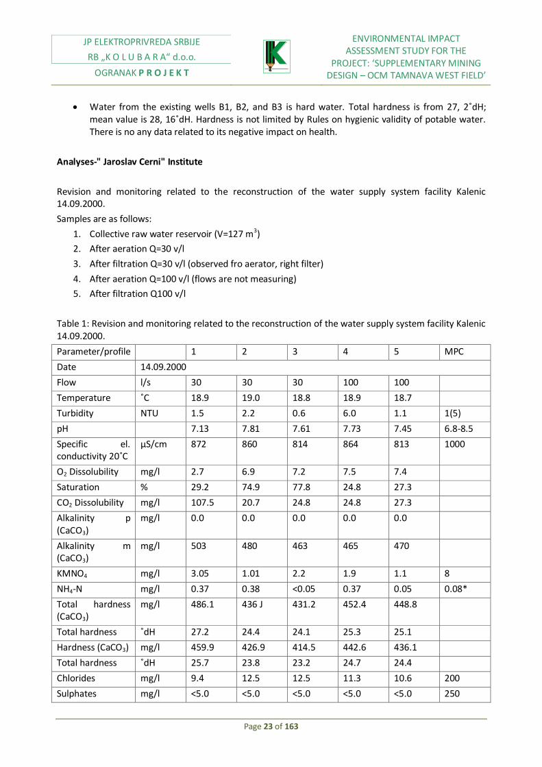
Water from the existing wells B1, B2, and B3 is hard water. Total hardness is from 27, 2˚dH; mean value is 28, 16˚dH. Hardness is not limited by Rules on hygienic validity of potable water. There is no any data related to its negative impact on health.
Analyses-" Jaroslav Cerni" Institute
Revision and monitoring related to the reconstruction of the water supply system facility Kalenic 14.09.2000.
Samples are as follows:
1. Collective raw water reservoir (V=127 m3)
2. After aeration Q=30 v/l
3. After filtration Q=30 v/l (observed fro aerator, right filter)
4. After aeration Q=100 v/l (flows are not measuring)
5. After filtration Q100 v/l
Table 1: Revision and monitoring related to the reconstruction of the water supply system facility Kalenic 14.09.2000.
Parameter/profile 1 2 3 4 5 MPC
Date 14.09.2000
Flow l/s 30 30 30 100 100
Temperature ˚C 18.9 19.0 18.8 18.9 18.7
Turbidity NTU 1.5 2.2 0.6 6.0 1.1 1(5)
pH 7.13 7.81 7.61 7.73 7.45 6.8-8.5
Specific el. conductivity 20˚C
μS/cm 872 860 814 864 813 1000
O2 Dissolubility mg/l 2.7 6.9 7.2 7.5 7.4
Saturation % 29.2 74.9 77.8 24.8 27.3
CO2 Dissolubility mg/l 107.5 20.7 24.8 24.8 27.3
Alkalinity p (CaCO3)
mg/l 0.0 0.0 0.0 0.0 0.0
Alkalinity m (CaCO3)
mg/l 503 480 463 465 470
KMNO4 mg/l 3.05 1.01 2.2 1.9 1.1 8
NH4-N mg/l 0.37 0.38 <0.05 0.37 0.05 0.08*
Total hardness (CaCO3)
mg/l 486.1 436 J 431.2 452.4 448.8
Total hardness ˚dH 27.2 24.4 24.1 25.3 25.1
Hardness (CaCO3) mg/l 459.9 426.9 414.5 442.6 436.1
Total hardness ˚dH 25.7 23.8 23.2 24.7 24.4
Chlorides mg/l 9.4 12.5 12.5 11.3 10.6 200
Sulphates mg/l <5.0 <5.0 <5.0 <5.0 <5.0 250

JP ELEKTROPRIVREDA SRBIJE
RB „K O L U B A R A“ d.o.o.
OGRANAK P R O J E K T
ENVIRONMENTAL IMPACT ASSESSMENT STUDY FOR THE
PROJECT: ‘SUPPLEMENTARY MINING DESIGN – OCM TAMNAVA WEST FIELD’
Page 24 of 163
Silicates mg/l 48.0 47.5 47.5 47.5 47.5
Fe mg/l 0.31 0.34 0.05 1.99 0.10 0.3
Mn mg/l 0.12 0.12 0.05 0.17 0.04 0.05
O2 according to Vinkler
mg/l 3.98 8.03 8.95 8.50 7.48
Analysis results of well water
Sample: Raw well water
Sampling date: 30.09.1999
Table 2: Raw well water analysis results, 30.09.1999
Parameter Water sample MPC value according to the rules № 42/98
KMnO4 4.1 Up to 8
Ammonia, mg/l 062 0.1
Dry residue mg/l 550 n.d.
pH value 6.6 6.8-8.5
Electric conductivity micro S7cm 740 Up to 1000
Total hardness mg/l 29 n.d
Iron mg/l 0.745 0.3
Manganese, mg/l 0.161 0.05
Calcium, mg/l 119.2 200.0
Magnesium, mg/l 53.4 50.0
Sodium, mg/l 18.2 150.0
Potassium, mg/l 17.6 12.0
Zink, mg/l 0.14 3.0
Watercourses vicinity
Hydro geology of "Tamnava West Field deposit" includes rivers, small rivers, and streams with constant and periodic flow. Each flow belongs to the catchment area of river Kolubara, which has its direction east from deposit. River Kolubara belongs to the River Danube catchment area. The only constant surface flow within deposit is River Kladnica with course direction from sought west, towards north east. River Kladnica has characteristics of calm, quite and low land river. Ravines, like Duboki potok, have water only during rainy period.
Upstream from "Tamnava West field" deposit, at River Kladnica, between Paljuv and Vis, earth dam was constructed and reservoir was created for the goal of open cast mine protection against surface waters.

JP ELEKTROPRIVREDA SRBIJE
RB „K O L U B A R A“ d.o.o.
OGRANAK P R O J E K T
ENVIRONMENTAL IMPACT ASSESSMENT STUDY FOR THE
PROJECT: ‘SUPPLEMENTARY MINING DESIGN – OCM TAMNAVA WEST FIELD’
Page 25 of 163
Hydro morphological terrain characteristics
As the case is with hydro meteorological characteristics of River Kolubara catchment area, with special observation to its low course, hydro morphological characteristics of River Kolubara and its tributaries, have been analyzed in detail as follows:
Flow
Flood
Low water
Alluviums
Based on the above mentioned characteristics, analysis of water course and flow characteristics of River Kolubara and its tributaries, has been performed, at the open cast mine area. Systematic measurements at River Kolubara initiated in 1950, by placing of water gauge station in Drazevac, downstream from "Tamnava" deposit. Daily and monthly flows of Kolubara and its tributaries fluctuate in wide ranges.
At the station in Drazevac, monthly flows measurements are as follows:
10,6 m3/sec –the lowest
22,6 m3/sec –an average
146 m3/sec – the highest
Season flows are not in accordance with calendar season, although water amount is nearly related to the season character. Trimester with the highest water amount is February – April, with share of 42% of total annual flow, then May – July with share of 26%, and trimester with the lowest water amount is August – October with share of 10%.
Orthographic-morphologic characteristics of terrain and hydrological regime of River Kolubara and its tributaries is conditioned by introduction of new measurements stations at deposit areas (observations are in progress), so reliable data could be achieved, for the needs of regulation of Kolubara, Kladnica, Vrancine watercourses, and for the purpose of open cast mines protection against surface waters.
2.4 Population or location development
Most of the existing population of Kolubara Basin originates from settlers which, during past two centuries, have formed agricultural communities. Populated areas are organized in the manner of village settlements and scattered villages containing small groups of houses, surrounded by big parcels of arable land. Little villages are prevailing, because more than 50% settlements have less than 2000 inhabitants. The entire area of Kolubara Basin is characterized by small population density, low urbanization level and small villages.
Lazarevac is municipal, administrative, legal, commercial centre, as well as the centre including different kinds of services. It is located 15 km in direction sought west from "Tamnava West field". The entire population gravitates around this center. Stepojevac, as one of the biggest villages and Crljeni, are providing services of local significance. Each other village has facilities for service providing, and basically are the part of Lazarevac.

JP ELEKTROPRIVREDA SRBIJE
RB „K O L U B A R A“ d.o.o.
OGRANAK P R O J E K T
ENVIRONMENTAL IMPACT ASSESSMENT STUDY FOR THE
PROJECT: ‘SUPPLEMENTARY MINING DESIGN – OCM TAMNAVA WEST FIELD’
Page 26 of 163
During fifties and sixties in Kolubara Basin, serious migrations occurred as the consequence of desire for moving to the bigger cities. This type of population movement is occurred simultaneously with activities at open cast mines in Kolubara, which offered employment possibilities for the younger population.
Communities Lazarevac and Ub have positive migration rate from the beginning of mining activities, while at the area of Lajkovac negative rate is recorded.
Typical property at Kolubara area has 6-7 ha, and most of households have one or two parcels in its possession. Some of households also have meadows and forests, especially in the area of River Kladnica.
Main economic factor at the area of Kolubara is coal generation and processing, together with electricity generation.
Mining industry development and electricity generation development initiated after the Second World War, while development was accelerated during sixties and seventies, followed by high growth rates and capital investments. Development of mines, plants, and other industrial facilities, encouraged not only industrial, but also the entire area development, with economic structure change. Construction of new trade centers caused rapid and far-reaching changes in the field of economic structure, employment, while, industrial activities, civil engineering activities and trade, traffic development turn municipalities at this area in actual industrial centers.
Increased growth rate and different social – economic conditions have stimulated social- economic environment and reached:
Constant population growth at the wider area
Rapid improvement of living conditions
Change in population economic structure, and increased employment rate outside agriculture, and reduction of active farmers
Village population migrations towards Lazarevac and other centers, in which employment out of the agricultural area is being created.
Employment rate are significantly different in bigger cities, which may be seen from the table below.
Table 3: Employment rate in subject area (2000)
Activity Lazarevac % Lajkovac % Ub %
Mining and Industry 78,0 56,9 49,8 Agriculture and Fishery 0,2 5,4 7,2 Forestry 0,0 0,0 0,0 Water management funds 0,1 0,0 0,0 Buildings 8,0 9,8 4,4 Traffic and transport 4,5 10,0 6,8 Trade 0,4 8,0 13,3 Catering industry and tourism 4,4 0,7 4,6 Trades 0,1 0,9 1,5 Housing and public services 2,7 2,4 2,4 Financial and other services 1,5 5,8 10,0 Total 100,0 100,0 100,0

JP ELEKTROPRIVREDA SRBIJE
RB „K O L U B A R A“ d.o.o.
OGRANAK P R O J E K T
ENVIRONMENTAL IMPACT ASSESSMENT STUDY FOR THE
PROJECT: ‘SUPPLEMENTARY MINING DESIGN – OCM TAMNAVA WEST FIELD’
Page 27 of 163
Employed within industrial sector are prevailing at municipalities of Lazarevac. More than 50% of them, approximately 58% are employed in mining industry and coal processing (at the open cast mine).
Second significant sector is metal processing sector (mechanization, equipment, electric devices production) which employs about 20.8% of workers. Food industry, textile, leather industry, wood processing industry, rubber and plastic industry, building material industry and non metal industry are employing total of 20% of industrial employers.
Agriculture also presents important industrial branch of this area: more than 70% of land is covered with arable land, but it employs only 30% of population.
Agriculture is in transition period, through some serious changes, due to arable land is constantly being reduced, due to extension of mining activities, road construction…It turns to be some kind of additional activity for many residents, because they are cultivating land for their own needs. Farmers usually own land with orchards and vineyards (98%). Prevailing crops are corn, wheat, rye, oats and barley. Vegetable crops are also significant: potato, pepper, beans, cabbage, onions, peas… Growing plants for the purpose of processing (sugar beet, sunflower) is quite limited.
Industrial activities, present at the area of Lazarevac, Lajkovac, Ub are as follows: coal mining, electricity generation, metal processing industry, industry of electric devices, rubber and plastic industry, building material industry, food industry, wood processing industry, textile and leather industry, non metal industry, chemical industry and transport. Industrial activities with the biggest share are coal mining, and electricity generation, while others have smaller share.
Significant investments are implemented within power sector, which indicates priority and importance of mining activities, while share of other branches is quite marginal. This dominant role is particularly visible in municipality of Lazarevac (86, 2%) and Lajkovac (84, 3%), where some of the largest production capacities of Electric Power Industry of Serbia are situated.
The most important road at Kolubara area is Ibarska Magistrala. It connects Belgrade with Monte Negro. Although it is situated near capital city, main direction of national traffic network does not pass through Tamnava West field. The nearest place of the thoroughfare E-75 (north to sought direction) is almost 50 km towards east, while its west part toward Valjevo and Tuzla passing through sought part of Kolubara basin.
Other roads are of local interests. Local transport network is quite developed, since it is considered satisfied for communication between village and populated parts of this area.
The subject area is very close to the railway Belgrade – Bar, which is passing along part of the road Vreoci – Lazarevac. Both thermal power plants "Nikola Tesla A" and" Nikola Tesla B" are connected by railway enabling constant coal supplying.
Three power line routes are passing through the mining area, with voltage 35 kV, Istok I, II and III, for the purpose of supplying of OCM "Tamnava East field", as well as recreation center facilities.

JP ELEKTROPRIVREDA SRBIJE
RB „K O L U B A R A“ d.o.o.
OGRANAK P R O J E K T
ENVIRONMENTAL IMPACT ASSESSMENT STUDY FOR THE
PROJECT: ‘SUPPLEMENTARY MINING DESIGN – OCM TAMNAVA WEST FIELD’
Page 28 of 163
Figure 4: Power infrastructure of the area (Source: Spatial plan of mining area for Kolubara mining basin)
Subject terrain is rarely populated; it was a marsh land (before River Kolubara regulation), except the thoroughfare Belgrade – Gornji Milanovac and Veliki Crljeni – Cvetovac.

JP ELEKTROPRIVREDA SRBIJE
RB „K O L U B A R A“ d.o.o.
OGRANAK P R O J E K T
ENVIRONMENTAL IMPACT ASSESSMENT STUDY FOR THE
PROJECT: ‘SUPPLEMENTARY MINING DESIGN – OCM TAMNAVA WEST FIELD’
Page 29 of 163
Figure 5: Road and railway network (Source: Spatial plan of mining area for Kolubara mining basin)
Dense settlement along these roads was developed for the last twenty years and it is populated mostly by population resettled during development of "Tamnava West field".
Placing boundaries of the open cast mines is implemented in the manner which does not require household’s resettlements.

JP ELEKTROPRIVREDA SRBIJE
RB „K O L U B A R A“ d.o.o.
OGRANAK P R O J E K T
ENVIRONMENTAL IMPACT ASSESSMENT STUDY FOR THE
PROJECT: ‘SUPPLEMENTARY MINING DESIGN – OCM TAMNAVA WEST FIELD’
Page 30 of 163
2.5. Natural recourses at the subject location, with special observation at the presence of swamps surface or ground waters, forests, agricultural land, fishing and hunting areas, mineral raw materials …
Lignite is the most significant mining treasure at the subject location and surrounding area, covering an area of three municipalities. Municipality of Ub area is extremely rich in stone sites, dolomite sites, quartz sand, clay, which is good base for construction material.
Simultaneously with coal mining, in municipality of Lazarevac, other industrial branches have been developed, due to existence of other natural resources: diatomaceous earth in Barosevac, kaolin clay in Rudovci, quartz sands in Zeoke. There is very quality stone, named "Brajkovac granite" in Brajkovac, used for facades building.
There are many springs, different mineral waters suitable for therapeutic use.
Ground waters reservoirs are significant, especially for river alluvial. Based on this, few pumping stations systems were developed: regional system "Nepricava", municipality system "Pestan", local system "Vreoci"," Medosevac "and" Veliki Crljeni". These systems have developed water supply network and water treatment facilities. Other water supply systems are down to local use.
Land use
At "Tamnava West field" area, land is currently used for agricultural purposes, including pastures for grazing. Villages Kalenic, Mali Borak and Skobalj are scattered in the area. There are several parts covered with forest vegetation, mainly near River Kladnica and Duboki Potok.
Usable land structure at this area will be affected by mining activities at Tamnava West, as it can be seen in table below.
Table 4: Land use structure at Tamnava West (ha)
Ub community Lajkovac community Total Kalenic Radljevo M.Borak Skobalj
Ara
ble
lan
d
Fields 454.10 238.61 521.58 160.00 1374.29 Gardens 0.72 0 0 0 0.72 Vineyards 1.01 0 0.10 0 1.12 Orchards 30.95 9.38 22.11 7.43 69.87 Meadows 62.76 15.79 44.54 37.82 160.91 Pasture 33.33 19.71 52.63 26.63 132.30
Трстици 0.34 0 0 0 0.34
Forests 36.27 57.47 10.93 182.30 Total arable land 660.87 319.76 698.43 242.81 1921.86
Bar
ren
lan
d
Yards 10.07 4.90 9.98 2.45 27.40
Roads 5.78 1.41 10.00 10.64 27.83 waters 0 0.52 0 7,17 7.69
Infertile 30.62 0.18 21.86 0.11 62.77
Total barren land 46.47 7.01 4184 20.38 115.70 TOTAL 707.34 326.77 740.27 263.18 2037.56
Source: EPS
With over 70% of cultivated fields and vegetable gardens, general land use could be classified as agricultural. Recently, these activities have been intensified.

JP ELEKTROPRIVREDA SRBIJE
RB „K O L U B A R A“ d.o.o.
OGRANAK P R O J E K T
ENVIRONMENTAL IMPACT ASSESSMENT STUDY FOR THE
PROJECT: ‘SUPPLEMENTARY MINING DESIGN – OCM TAMNAVA WEST FIELD’
Page 31 of 163
Besides perennial plantations, orchards are prevailing, compared to vineyards (4.3% - 3.00%). Limit between terrain with low and terrain with high percent of land covered with plantations, is quite clear. Percent increase was recorded in the zone of Celije, Petka, Lazarevac, Susnjare, Stubice, Burovo, Dren, Bistrica, Mali Crljeni, Prkosava, Strmovo, reaching the highest percentage (8.1% - 13.3%).
Regulation plan (Official Gazette RS 44/95) defines criteria for land use and terrain protection. It is of high importance for land use planning in the area of Kolubara basin which is currently affected by changes due to mining activities. Spatial plan for "Tamnava West field" area is prepared and currently is in public consultation procedure. It is expected for spatial plan to be adopted, and afterwards, to be announced as official legal act, by which it would be effective.
In the meantime, starting from April, 2000 official order is issued, on prohibition of all activities of new house holdings construction, or agricultural building within defined parts of Kolubara basin, including those near Tamnava West, except those related to mining activities.
In accordance with the regulation plans, from 1997, for Brgule and Radljevo, extended area directly related to the west part of the mine Tamnava West, is reserved for agricultural activities.
Few restrictions were adopted on construction activities, related to existing houses reconstruction, stables extension, barns, and other auxiliary buildings. These activities are limited to the absolutely necessary level, so farmers could achieve normal agricultural production, while their resettlement to another location would not be executed. Objects which exceed established standards from regulation plans would not be paid in case of mining activities extension at this area.
As regards the settlement Novi Kalenic, it is important to have in mind that regulation plan for this place from 1994, was followed by Law on Spatial Planning from 1989, so it was not in accordance with the new Law on Spatial Planning from 1995, by which certain requests regarding public facilities and infrastructure were defined in more details.
At the area of Kolubara, it is possible to specify following forest communities:
Forests of white willows are mainly along River Tamnava tributaries,
Forest of bay oak, which is located near forests of white willows,
Mixed forests of bay oak and hornbeam are the most common in this area,
Forests of bay oak and hornbeam with lime are located in hill areas
Forest of shrubby oak and hornbeam near village Barosevac, covers protected areas in west and northwest direction,
Forest of shrubby oak and common hornbeam with Hungarian oak covers slopes with the inclination about 20%, turn to east and northeast direction,
Forests of beech are in depression located near Barosevac village,
Hungarian oak forest is one of the most common in this area, and indicates environmental conditions prevailing in this area,
Shrubby oak forest with moss is growing at the shallow soil with expressed acid reaction,
Silver linden forest covers the area near Sokolovo village (Veliki Crljeni)

JP ELEKTROPRIVREDA SRBIJE
RB „K O L U B A R A“ d.o.o.
OGRANAK P R O J E K T
ENVIRONMENTAL IMPACT ASSESSMENT STUDY FOR THE
PROJECT: ‘SUPPLEMENTARY MINING DESIGN – OCM TAMNAVA WEST FIELD’
Page 32 of 163
At low land area of Kolubara, peat land vegetation is present, and also a swamp with reed and sedge. Sedge is usually can be found in depressions filled with water, during the entire year.
Concerning surface waters in this area, they include rivers, small rivers, and streams. River Kolubara belongs to Danube basin. The only constant surface flow within deposit is River Kladnica with course direction from sought west towards north east. River Kladnica has characteristics of calm, quite and low land river. Ravines, like Duboki potok, have water only in rainy period.
Upstream from "Tamnava West field" deposit, at River Kladnica, between Paljuv and Vis, earth dam was constructed and reservoir was create for the goal of open cast mine protection against surface waters.
Stuborovni reservoir is located around 10 km from Tamnava West field, on River Jablanica. It is still under construction. Dam height is 74 m, and dam crest elevation is 363 m above sea level. An effective reservoir capacity is 49.5 mill m3, and it can regulate water course of River Jablanica during entire year, even longer.
It is important to point out, that "Tamnava West field" has complex hydrological conditions. It can be seen within periodically changing of collector and isolator with different effect on coal mining. Also, there are big reserves of quality water collected in roof, and floor coal seams. Lake at Paljuvim enables development of sport fishing tourism.
2.6. Locations affected by earthquakes, land subsidence by landslides, erosion, flood, temperature differences, common fogs, and strong winds
Seismic investigations
In course of 1976, within geologic investigations for the needs of thermal power plant construction, seismic regionalization is preformed for the entire Kolubara basin, as well as micro seismic regionalization of economically active area at location of future thermal power plants. Study and development of the appropriate subject documents were performed by Seismic office RS. Based on seismic regionalization of RS from 1973, the area of Tamnava West Field belongs to the 6TH seismic level according to MSS scale.
Modern geodynamic processes
Geodynamic processes at Tamnava West field area are active, as follows:
Surface decay crust until recently did not separate as one particular creation. During engineering-geological investigations results, it could be noticed that within quaternary clays always is appearing Fe and Mn oxides in the shape of grain or skim, and CaCO3 in the shape of concretions or dust. These kinds of appearances are characteristic for rock chemical change, i.e., surface decay. In course of mapping, it can b seen crumb like structure, characteristic for mechanical decay. This process is not only developed in quaternary clays, but it can be followed to the rock mass of alevrite. Crust thickness is approximately up to 25m.

JP ELEKTROPRIVREDA SRBIJE
RB „K O L U B A R A“ d.o.o.
OGRANAK P R O J E K T
ENVIRONMENTAL IMPACT ASSESSMENT STUDY FOR THE
PROJECT: ‘SUPPLEMENTARY MINING DESIGN – OCM TAMNAVA WEST FIELD’
Page 33 of 163
Washing is performed along cut surfaces of terrain, operating slopes, by precipitation. Reservoir creation of this process – diluvium, is made of quaternary clays, terrace sandy clays, and alevrite. Its thickness cannot be measured precisely, because in its reservoir zone mining activities are performing.
Dredging is process in which are formed ravines of erosive groove, with depth up to 1 m, in higher parts of operating slopes of the first and second ECS system.
Land sliding is hard movement of rock masses along sliding surfaces, with slope to 40-50˚ and it is characteristic for the second ECS system, which excavates alevrite. This kind of appearances could be expected in the period after long rains. The cause of sliding plains creation is hardness reduction due to terrain vibrations by dynamic load of mining equipment, transporters, and water drenching, which may cause swelling, by that and rock mass movement.
Sliding as geodynamic process was shown at part of deposit near graveyard Kalenic, in 1997. Rock filtration destruction is process taking place along lateral slopes in west part of terrace sediments where cavernous are appearing. These morphologic processes present the consequence of filtration activity of ground waters.
Geological operation of atmosphere and ground waters is manifested by rocks decay under the effects of temperature and frost.
Technological processes are expressed in each open cast mine. They are created by every day cutting, bulk filling, and dewatering, static and dynamic loading.
Flood risks in area of Tamnava are on high level due to water courses characteristics. Main tributaries of River Kolubara are Pestan, Turija, Kladnica, Tamnava, Vranicina, and Ub.
Table 5: Rivers characteristics
River
Measurement station
Water intake surface (км2)
Mean water flow (m3/s)
Min. (95%) average маx1%
Kolubara
Drazevac 3588 - 20.80 - Beli Brod 1869 1.80 16.06 - Slovac 995 1.04 9.47 337 Valjevo 340 0.18 3.66 306
Kladnica Paljuvi Vis 74 - 0.26 - Tamnava Koceljeva 208 - 1.22 - Pestan Zeoke 125 - 0.78 - Ub Ub 214 - 0.97 -
River Kolubara banks are mainly unstable, and riverbed is curves due to different soil type in subject area. Season flows are not in accordance with calendar season, although water amount is nearly of season character. Trimester with the highest water amount is February – April, with share of 42% of total annual flow, then May – July with the share of 26%, and trimester with the lowest water amount is August – October with share of 10%.
Reservoir system is planned for construction, for the purpose of flood protection, ad some of them are already under construction (Paljuvi, Vis, Stuborovni). Water from these reservoirs is used in agriculture and for industrial purpose, including cooling water for thermal power plants Kolubara A and Kolubara B. Planned system will provide high level capacities for flood protection, with reveres probability one time in five hundred years.
Stuborovni reservoir is located around 10 km from Tamnava West field, on River Jablanica. It is still under construction. Dam height is 74 m, and dam crest elevation is 363 m above sea level. An effective

JP ELEKTROPRIVREDA SRBIJE
RB „K O L U B A R A“ d.o.o.
OGRANAK P R O J E K T
ENVIRONMENTAL IMPACT ASSESSMENT STUDY FOR THE
PROJECT: ‘SUPPLEMENTARY MINING DESIGN – OCM TAMNAVA WEST FIELD’
Page 34 of 163
reservoir capacity is 49.5 mill m3, and it can regulate water course of River Jablanica during entire year, even longer.
Paljuvi Vis reservoir at River Kladnica is constructed in 1984 for the purpose of Kolubara mining basin supplying. Altitude of this reservoir is 115 m. Water is stopped with embankment with height 15, 8 m. Reservoir capacity is nearly 350.000 m3. Dam crest elevation is 760 m. This reservoir will be of high importance, before Stuborovni reservoir is commissioned.
Climate changes impacts
Wider area of Kolubara basin is characterized by continental climate, with relatively worm summers and mild cold winters. Based on data, obtained by measurements of particulate climate elements (air temperature and humidity, snow cover level, soil temperature, direction and wind speed…) in meteorological station Kalenic, conclusions on micro climate characteristics could be performed:
Air temperature
1. Mean daily air temperature:
Winter +1, 5 ˚C
Spring +11, 5˚C
Summer +21, 0˚C
Autumn +12, 3˚C
2. Mean monthly air temperature:
The lowest in January +0, 5˚C
The highest in July and August +19, 7˚C
3. Mean annual air temperature +11, 6˚C
Precipitation
According to the annual precipitation amount, this area is moderately humid area with average precipitation amount of 650-1000 mm.
1. Mean monthly precipitation amount are:
Maximal in June, July and August (281-293 mm)
Minimal in January and February (83,5 mm)
Snow cover level >50 cm in low land region of this area is relatively rare and it usually lasts for one day only, while average snow cover level for this area is characteristic for period 15.12.-01.03. is 10 cm (for 17-19 days).

JP ELEKTROPRIVREDA SRBIJE
RB „K O L U B A R A“ d.o.o.
OGRANAK P R O J E K T
ENVIRONMENTAL IMPACT ASSESSMENT STUDY FOR THE
PROJECT: ‘SUPPLEMENTARY MINING DESIGN – OCM TAMNAVA WEST FIELD’
Page 35 of 163
Evaporation
Maximal values are recorded in July and August (220mm), and minimal in December and January (20 mm).Evaporation is the highest in June (158 mm), and the lowest in January (18 mm) for soil under lower vegetation.
Winds
Strong winds are not common in subject area. The most common are from west direction and northwest, strength of 6 Beaufort s (11-14 m/s), and last 12, 3 days per year, and the most common are in period April-August. Based on observation data from period 1974-1988 Seismic Station Tamnava, that is GMS Valjevo, wind frequency from different directions and silence occurrence, as well as mean wind velocity for 16 directions, that is, 8 main directions, were calculated. Obtained values are given in Table 6, as well as in graphic of so called "wind rose", at Figure 8, for GMS Valjevo.
Table 6
Type Direction
Silence N NE E SE S SW W NW
1 2 3 4 5 6 7 8 9 10
frequency % 3.9 5.8 8.0 3.2 1.7 3.9 18.2 8.4 46.9
Speed (m/s) 2.5 2.2 2.6 3.2 3.4 2.5 2.3 2.9
Figure 8: Wind rose, period 1949-1991
Table 7: Frequency and wind speeds for SMS "Tamnava", period 1974-1988
Type Wind direction
Sile
nce

JP ELEKTROPRIVREDA SRBIJE
RB „K O L U B A R A“ d.o.o.
OGRANAK P R O J E K T
ENVIRONMENTAL IMPACT ASSESSMENT STUDY FOR THE
PROJECT: ‘SUPPLEMENTARY MINING DESIGN – OCM TAMNAVA WEST FIELD’
Page 36 of 163
N
NN
E
NE
ENE
Е ЕSЕ
SЕ
SSE
S SSW
SW
WSW
W
WN
W
NW
NN
W
1 2 3 4 5 6 7 8 9 10 11 12 13 14 15 16 17 18
frequency
%
3.6
0.6
0.3
0.5
2.8
7.5
2.5
1.4 1.4
.0.3
0.3 0.6
3.4
5.5
3.0 2.3
64
speed
(m/s)
2.3
1.4
1.3
1.2
1.8
2.9
2.4
1.8 1.9
1.9 2.0 1.7
2.1
2.6
2.3 2.0
Concerning wind direction, it is evidenced that they most commonly are blowing form west and northwest direction (expressed in Valjevo), specific for summer period, and from east and east-southeast (Typically for Tamnava), that is east and north east (specific for Valjevo)
2.7. Presence of hospitals, schools, kinder gardens, religious buildings, public facilities at the location
Part of the land, is currently used for production on Tamnava West field exceeds more than 2.5 km2. Complete area used for coal mining, will be extended as the result of continuous operation, and by 2005 will be necessary 4.6 km2, and by 2010 7.3 km2 and about 12 km2 by 2020. Four villages will be resettled completely or partially, due to coal mining. Number of population need to be resettled is shown in Table 8.
Table 8: Villages which currently are within Tamnava West field borders
Name Number of households
Number of residents Source
Kalenic 81 201 Voting,1996 Radljevo 43 130 Local plan,1997 Mali Borak 214 619 Voting,1999 Skobalj 128 393 Voting,1999 Total 466 1343
Villages need to be resettled have a large number of public facilities like: elementary schools, local shops, medical centers, churches, and cemeteries which also need to be relocated.
Proposed mining activities would require obligatory purchase of about 2000 ha of agricultural land and/or uncultivated land.
Up until now, about 25% of necessary land is mainly at the area of Kalenic, and it is in EPS property.EPS also initiated relocation of Kalenic village, process includes both, land acquisition and compensation in the way of households providing, village infrastructure and also pecuniary compensation.

JP ELEKTROPRIVREDA SRBIJE
RB „K O L U B A R A“ d.o.o.
OGRANAK P R O J E K T
ENVIRONMENTAL IMPACT ASSESSMENT STUDY FOR THE
PROJECT: ‘SUPPLEMENTARY MINING DESIGN – OCM TAMNAVA WEST FIELD’
Page 37 of 163
The elementary school and ancillary building for school stuff have already being built in Novi Kalenic. Part of the infrastructure is completed, such as big part of water supply system, part of sewage system and electricity distribution. Children’s playgrounds and soccer stadium with all necessary facilities are also located there.
Near open cast mine, TPP Nikola Tesla A is located with its dump, and also in south-southeast direction there are open cast mines field D and field B. Open cast mine Tamnava East field is situated along open cast mine Tamnava West field. Annually, approximately 25 t of coal is excavated, which is combusted in TPP Nikola Tesla A, TPP Nikola Tesla B, TPP Kolubara A and part of TPP Morava.
At distance of 10-15 km from open cast mine Tamnava West, there is industrial complex "Kolubara Prerada", in which coal is being processed (coal crushing and separation) for the needs of thermal power plant and raw coal drying (about 700.000 t/annually is generated), for the needs of industrial and wider consumption. At Junkovac location, industrial complex" Kolubara Prerada" has its own dump situated. At distance of 20 km, in northwest direction, TPP Nikola Tesla B is situated with its dumps.
2.8. Area on or near location on which protected, important or sensitive plant and animal species are used
In accordance with the Environmental Law protected area is established near Lazarevac and Ibarska Magistrala. This area is rich with bay oak (Quercus robur) and ash (Fraxinus oxicarpa).
Hunting Act protects animal species which are present in this area. According to this law, some species are permanently protected from hunting or their hunting is limited to hunting seasons. Permanent prohibition is introduced for the following species: skunk (Putonus putonu L.), little weasel (Mustela nivalis L), otter (Vudra vudra L), lapwing (Vanellus vanellus L,), cresed duck (Aythia Fuliguta L.), pink heron (Ardea purpurea L), little white heron (Egretla garzetta L), yellow heron (Ardeola rolloides Scop,), rabble rouser (Ixobrichus minutus L), ветруша кликтавка (Falco tinnunculus L), red legged hawk (Falco vespertinus L), buzzard (Buteo bueto L), kite (Cyrcus cyaneus L.), owl (Otus scops L), little owl (Athene noctua Scop.).
Besides previously mentioned species, forest ant (Formica rufa L.) and its anthills are protected by particulate provisions of the above mentioned Environmental Law ; as well as all types of blind mice and their habitats.
There are no data indicating that some of this species are located in the area of Tamnava Wets field.
2.9. Velocity of important roads or facilities for public access to recreation center and other facilities
The most important road at Kolubara area is Ibarska Magistrala. It connects Belgrade with Monte Negro. Although it is situated near capital city, main direction of national traffic network does not pass through Tamnava West field. The nearest place of the thoroughfare E-75 (north to sought direction) is almost 50 km towards east, while its west part toward Valjevo and Tuzla passing through sought part of Kolubara basin.

JP ELEKTROPRIVREDA SRBIJE
RB „K O L U B A R A“ d.o.o.
OGRANAK P R O J E K T
ENVIRONMENTAL IMPACT ASSESSMENT STUDY FOR THE
PROJECT: ‘SUPPLEMENTARY MINING DESIGN – OCM TAMNAVA WEST FIELD’
Page 38 of 163
Other roads are of local interests. Local transport network is quite developed, since it is considered satisfied for communication between village and populated parts of this area.
The subject area is very close to the railway Belgrade – Bar, which is passing along part of the road Vreoci – Lazarevac. Both thermal power plants "Nikola Tesla A" and" Nikola Tesla B" are connected by railway, enabling constant coal supplying.
2.10. Facilities for small business, tourism and trade at the subject location and its surroundings
Ub and Tamnava are farming area and our farmers are recognized agricultural manufacturers. Lignite is the most significant mining treasure at the subject location and surrounding area, covering an area of three municipalities. Municipality of Ub area is extremely rich in stone sites, dolomite sites, quartz sand, clay, which is good base for construction material. It has center for sports and recreation with football, basketball and volleyball court, and athletic track. Hunting is quite developed; lake in Paljuvi enables development of sports hunting. Ub is the city wants to be developed. There are many locations suitable for constructive development of different profitable contents: industrial zones, trade and business centers. In city center is located 50 ha of space suitable for all types of business activities, particularly for trade center construction. It is the space of enterprise "Ubljanka" with big halls, equipped with infrastructure, on road for Belgrade. Hall of the previous factory "Kerub" enables construction of industrial zone in the modern sense.
Industrial zone of Lajkovac includes cadastral lots Lajkovac and Jabucje and it is located near Ibarska Mgistrala, 65 km from Belgrade.
Industrial zone area is bordered by the railway Belgrade-Bar from north, west border is future zone of Belgrade-Bar railway, and south border is planned detour of the road M-4 (Belgrade-Valjevo), while east border is from future cross section of M-4 road and detour by channel to the railway Belgrade-Bar. It is planned for industrial gauge to be constructed and connected with Belgrade-Bar railway.
Economic environment
Agricultural and processing resources in livestock breeding, farming and fruit breeding
Positive investors experience - "Vindija" from Varazdin, owner of "Lajkovac Dairy"
Significant investments in Kolubara area, creating more favorable environment and encourage operation of small enterprises-households appliances factory "Gorenje" in Valjevo, Socks and underwear Italian factory "Valu" in Valjevo, "Voda-Voda" and "Sinalco" in Vrujci.
Effective Chamber of Commerce Valjevo, as economy and investors service
Economy
In economy structure of Lajkovac, the biggest share has agriculture in which an individual sector is the most significant. It has approximately 12500 ha of arable land. One of the famous agricultural cooperative in Serbia, 33 "Lajkovac" practically does not exist anymore. Capacities of mills, silos, dairies, refrigerators, and other local business facilities are waiting for better time to come and interests of the current owners, to be put in operation once again,
Within industrial zone of Lajkovac, act several private enterprises, which bring faster development of the entire municipality by its own activity. The most successful are "Borverk" and "Nodel". At only 30 km are

JP ELEKTROPRIVREDA SRBIJE
RB „K O L U B A R A“ d.o.o.
OGRANAK P R O J E K T
ENVIRONMENTAL IMPACT ASSESSMENT STUDY FOR THE
PROJECT: ‘SUPPLEMENTARY MINING DESIGN – OCM TAMNAVA WEST FIELD’
Page 39 of 163
famous tourist destinations – Rajac and Divcibare. Agricultural center was founded in 1998, by joining of Agricultural livestock-veterinary center and Crop production center.
Lajkovac has an open sports activities courts, also an outstanding soccer court. One big municipality investment is in progress – forming of sports and recreation center with outdoor pools near the court. Lignite is the most significant mining treasure at the subject location and surrounding area, covering an area of three municipalities. Municipality of Ub area is extremely rich in stone sites, dolomite sites, quartz sand, clay, which is good base for construction material.
Simultaneously with coal mining, in municipality of Lazarevac, other industrial branches have been developed, due to existence of other natural resources: diatomaceous earth in Barosevac, kaolin clay in Rudovci, quartz sands in Zeoke. There is very quality stone, named "Brajkovac granite" in Brajkovac, used for facades building.
There are many springs, different mineral waters suitable for therapeutic use.
Ground waters reservoirs are significant, especially for river alluvial. Based on this, few pumping stations systems were developed: regional system "Nepricava", municipality system "Pestan", local system "Vreoci"," Medosevac "and" Veliki Crljeni". These systems have developed water supply network and water treatment facilities. Other water supply systems are down to local use.
Regarding hotel capacity, for the future needs is predicted a small motel construction in recreation center named "Ocaga" and extension of "Vis" hotel. Catering, within small economy sector, covers each populated place, and it is suitable for the people needs. This area is full of little lakes created by people’s action. Lake Ocaga is located at 60 km from Belgrade; it is "real pearl". It has spring water, which every day gets filtrated by modern devices. Beside it, there is Stara Ocaga, which provides the feeling of untouched nature. Lake in Cvetovac was created by people’s action, and also few small lakes between Vreoci and Rudovci. Lake Paljuvi, in the next municipality is not so far away. They all are situated in depressions, surrounding by forests, giving relaxation and enjoyment. Shooting range Tamnava was developed in 1992 and it is situated at 18 km from Lazarevac towards Ub that is 2 km distant from Ibarska Magistrala. At Tamnava dump sides, off – road races already have been held. Big sports center "TEK" in Veliki Crljeni, besides soccer court includes indoor swimming pool, basketball playground, gym, and other auxiliary facilities. Other places have, either sport centers or soccer court. 2.11. Lay-out plan – graphics
3. VIEW OF CURRENT ENVIRONMENT STATE (Micro and macro location)
Development of intensive lignite mining at open cast mines of Kolubara Basin, as well as development of processing and thermal capacities based on that lignite, is responsible for strong industrial-economic development of Serbia in sixties and seventies, but simultaneously caused negative changes in each environment segment of area of Kolubara. Considering diversity and complexity of energy sector development and environmental protection for the past two decades, many studies and environment analyses were developed by the science institutions, universities, design organizations and experts, which primarily were directed on development issues of new thermal capacities construction and their effects on the environment. Besides that, many study-research studies: cadastre of pollutants development, development of
JP ELEKTROPRIVREDA SRBIJE
RB „K O L U B A R A“ d.o.o.
OGRANAK P R O J E K T
ENVIRONMENTAL IMPACT ASSESSMENT STUDY FOR THE
PROJECT: ‘SUPPLEMENTARY MINING DESIGN – OCM TAMNAVA WEST FIELD’
Page 40 of 163
systematized environment monitoring. Those researches analyses indicated that it is possible to establish one integral informational system on the environment at OCM Kolubara area, but until today, that kind of system has not been established in practice. OCM "Kolubara" development improved social-economic area development. However, mining activities, and scope and efficiency of lignite utilization within mining complex of OCM "Kolubara", are main sources of negative changes within environment, with certain impact on the wider environment. Basic ecological disorders at the subject area occurred under the influence of mining activities on natural eco systems, and especially on agricultural and forest eco systems. Open cast mining dynamics have progressively destroyed, during last 50 year, quality agricultural land which is above lignite deposits, simultaneously changing morphological, hydrological, and other characteristics of the area. Power-industry complex has an ecological dimension manifested as pollution of air, soil, surface and underground waters, thermal loading of area, noise emissions… Mining-industrial development of area, encouraged development of settlements and infrastructure systems, but also created a conflict between mining and existing facilities located around open cast mining zone. Environment estimation is based on environment changes. Regarding analysis, relevant information on technological processes characteristics applied in MB "Kolubara", including implemented environmental protection measures; measurements data on some environment parameters… It can be stated that lignite production created negative direct consequences on the environment, which include: Destruction and occupation of fertile agricultural land,
Change of morphological and landscape characteristics of the subject area,
Flood risks increase,
Water pollution and soil by waters from ash disposal sites, oil derivates, detergents,
Inadequate disposal of industrial and communal solid waste Air pollution caused by dust from ash disposal sites and flue gasses from boiler rooms and vehicles
Increased noise and vibration level Results of the latest tests, requested for this study development, are given within Study Annex. It is important to point out that currently we have data on imission pollutants measurements and waste waters, while soil quality examinations are still in progress. 3.1. Waters (ground and surface)
3.1.1 Hydro-geology and ground water quality Based on extensive geological, geo-technical and hydrological examinations, ground water level, it is concluded that Tamnava West field deposit has complex hydrological conditions. That complexity is reflected by alteration of collectors and insulators with different coal mining impacts. Number of aquifers is established by drilling, and their mutual connections filling and emptying, as well as their hydrologic and hydrodynamic characteristics.

JP ELEKTROPRIVREDA SRBIJE
RB „K O L U B A R A“ d.o.o.
OGRANAK P R O J E K T
ENVIRONMENTAL IMPACT ASSESSMENT STUDY FOR THE
PROJECT: ‘SUPPLEMENTARY MINING DESIGN – OCM TAMNAVA WEST FIELD’
Page 41 of 163
Hydrological members Rock masses include the following: Hydrologic collectors Alluvial and terrace gravels,
Pontian sands,
Intermediate layers of sand, pontian sands,
Floor seam, pontian sands Hydrological insulators Quaternary clays,
Alevrites,
Coal series Aquifers are created within hydrological collector, which was conditioned by ratio of some lythological members. Compared with position towards coal series, aquifers are divided into: Roof seam aquifers
Intermediate layers aquifer
Floor seam aquifer Roof seam aquifers Above the coal series, in roof seam sediments, three aquifers with different hydrological and hydrodynamic characteristics are situated. For the purpose of oscillations monitoring of ground waters level, 118 piezometers were installed in roof hydrological collector, and 73 piezometers were damaged by different excavation works, while 24 are in process of function observation. 25 piezometers were installed within roof seam of upper pontian sands, 15 were damaged, and 2 are filled, and 8 could be observed. It is needed to point out that measurements of ground waters level have not been performed since 1994, and that they started again in 2004, and great deal of piezometers was filled, i.e.,, was not in measurement function. Aquifer in alluvial gravels and sands This aquifer consists of alluvial sediments of Kladnica and Kolubara. They occupy the smaller part of open cast mine "Tamnava West field". Ground waters collector is made by gravels and sands, of heterogeneous composition, from sand fraction to large quartz alluvial. Locally, they contain clay. Thickness of this collector is variable and it is in range 2-6 m, rarely up to 10m. General water direction is from sought-sought east towards northeast. Quaternary clays are on the top of alluvial sands and gravels having the function of hydrological isolator. Alevrite is situated within floor seam of gravels, and it is good consolidated, with function of hydrological floor isolator. Aquifer fillings are made of precipitations and surface watercourses. Drainage is performed by river bed Kladnica which in cases of high water level fill the aquifer. Hydrodynamic view of aquifer is quite been changed due to exploration works at open cast mines "Tamnava East field" and "Tamnava West field". It is different compared with the one which was in natural cases of filling and emptying. Ground water regime is been changed. Filtration ratio is defined based on grain size distribution, by method of USBR, and it is in limits n x 10-2- n x 10-7 m/s, the most common case is n x 10-4 m/s.

JP ELEKTROPRIVREDA SRBIJE
RB „K O L U B A R A“ d.o.o.
OGRANAK P R O J E K T
ENVIRONMENTAL IMPACT ASSESSMENT STUDY FOR THE
PROJECT: ‘SUPPLEMENTARY MINING DESIGN – OCM TAMNAVA WEST FIELD’
Page 42 of 163
A well B-1/k is constructed in this hydrological collector. By pumping data processing, the following hydrological parameters were obtained: k=2, 5x10⁻⁴ m/s, T=5, 8x10⁻⁴ m/s, a=2, 6x10⁻³ m2/s I, q=0, 6x10⁻³. Aquifers in terrace gravels At the area of "Tamnava West field “the biggest part of roof hydrological collector has been made of terrace gravels, in some parts it is saturated with clay. Grain size distribution is not equal. Thickness is in the range 2-12 m. Quaternary clays are on the top of terrace and alluvial sands and gravels having the function of hydrological isolator, with filtration ratio from n x10-9 m/s. At the bigger part of floor gravels, alevrite is situated, good consolidated, with hydrological isolator function, having filtration ratio n x10-8 m/s. Filtration ratio of terrace gravels is defined based on grain size distribution; it is in interval n x10-6 m/s. Aquifer filling is performed by precipitations infiltration, and emptying is performed by dewatering facilities at the open cast mine. Obtained hydrological parameters are shown in Table 9. Table 9. Hydro geological parameters from wells B-3/k and B-4/k
Mark
Hydro geological parameters
Filtration ratio
m/seс
Т
(transmobility)
m2/seс
а
(piezo conductivity)
m2/seс
Q
(specific capacity)
(l/s/m)
B-3/К 5,9x10⁻⁵ 1,9x10⁻⁴ 1,01 6,1x10⁻³
B-4/К 1,0x10⁻⁴ 1,9x10⁻⁴ 0,17 1,8x10⁻⁴
Aquifer in roof upper pontian sands At the OCM "Tamnava East field" is been discovered the appearance of upper pontian , gray-blue sands (seam 3a)and at the smaller area of quartz medium grained size sands white to light yellow color.(seam 3b). In general, "3a" sands are located in deposit area like ion thin layers, while "3b" sands in lance shape are located at the smeller area. A sand “3a” has the possibility of moving 13, 4 m, and "3b" sands to 23, 3 m. Aquifer filling is performed by precipitation infiltration, while the emptying is performed by seepage into dewatering facilities at the mine. 25 piezometers were installed within "3a" sands, 15 were damaged, and 2 are filled, and 8 could be in observation function. Water is under pressure, and filtration ratio is defined based on grain size distribution within limits n x 10-6 m/s. Sands floor seam consists of coal, and roof is mainly consists of alevrite. Aquifer in intermediate seams of sand Aquifer in intermediate seams of sands is compressed type; Collector consists of fine grained size to medium grained size quartz sands, having function of hydro geological collector. No well is constructed in this hydro geological collector. Its parameters are defined only based on grain size distribution, while regime and dynamics are defined only by ground waters level observation in 4 drill holes.

JP ELEKTROPRIVREDA SRBIJE
RB „K O L U B A R A“ d.o.o.
OGRANAK P R O J E K T
ENVIRONMENTAL IMPACT ASSESSMENT STUDY FOR THE
PROJECT: ‘SUPPLEMENTARY MINING DESIGN – OCM TAMNAVA WEST FIELD’
Page 43 of 163
22 piezometers are damaged by mining and other activities in this collector, 13 are filled, and 14 are in observation function. Their thickness is around 30m, and number of sands is variable, it is increasing from north to south. Sands are fine grained to medium grained size. Grain size distribution is quite uniform. Filtration ratio is in limits n x 10-5 m/s. Filling is performed out of mine borders, where top coal seam is affected by erosion, and gravels are situated directly over intermediate layers of sand, both creating complex type aquifer; its emptying is performed by dewatering facilities. Aquifer in floor sands Floor aquifer at OCM "Tamnava West field" is part of complex aquifer Kolubara which extends from Turija to Pestan in east direction, to Rivers Tamnava and Ub on in west and northwest direction. Besides exploration drill holes, floor collector is explored by 122 hydro geological drill holes and 7 wells. Hydro geological drill holes consist of piezometers constructions for oscillations aquifer level monitoring. From total number of installed piezometers constructions, 77 are damaged by mining and other activities, 28 are filled, 17 are in observation function. Filtration ratio is defined by grain size distribution in accordance with USBR method and it is in limits n x 10-5 m/s. 7 wells are constructed within this collector. Trial seepage is performed and collector hydro geological parameters are calculated. In natural conditions regime, aquifer is emptying into sediment in north part of deposit in zone where floor sands are in direct connection with quartz sands and gravels. Filling is performed out of mine borders, sought west from mine Radljevo, where floor sands are in direct hydraulic connection with surface waters. Table 10. Hydro geological parameters of floor wells
Well mark
Hydro geological parameters
k
Filtration ratio
(m/s)
T
Water permeability
(m2/s)
a
Piez. ratio
(m2/s)
Specific well yield
B-6/P 3,9x10⁻⁶ 3,9x10⁻⁴ 0,96 9,5x10⁻³
B-3/P 1,6x10⁻⁶ 1,6x10⁻⁴ 0,06 1,0x10⁻²
B-4/P 6,3x10⁻⁶ 6,3x10⁻⁴ 0,86 4,2x10⁻⁴
Obc/OE-160 2,1x10⁻⁵ 2,1x10⁻³ 0,62 4,0x10⁻³
Obc/OE-165 1,3x10⁻⁵ 1,3x10⁻³ 0,57 3,0x10⁻²
Obc/OE-170 2,3x10⁻⁵ 2,3x10⁻³ 0,7 2,0x10⁻³
OJ-171,25 1,0x10⁻⁵ 1,0x10⁻³ 0,6 2,0x10⁻³

JP ELEKTROPRIVREDA SRBIJE
RB „K O L U B A R A“ d.o.o.
OGRANAK P R O J E K T
ENVIRONMENTAL IMPACT ASSESSMENT STUDY FOR THE
PROJECT: ‘SUPPLEMENTARY MINING DESIGN – OCM TAMNAVA WEST FIELD’
Page 44 of 163
Ground water chemical characteristics Based on chemical analyses of ground waters, done by samples taken from piezometers, and waters analyses from experiment wells, it can be concluded that creation conditions of aquifer water in floor seam, intermediate lazes, and roof seam are identical and quite complex. Within chemical content of floor waters, hydro carbonate - magnesium type is prevailing. Similar situation is with waters created in intermediate layers of sand, even there is prevailing hydro carbonate-sulphate – calcium – magnesium type. Higher diversity level is shown with roof seam waters, where hydro carbonate-sulphate – calcium – magnesium type is most common. In general, waters from deposit of OCM "Tamnava West field" have low level of mineralization. It also can be concluded that, especially in roof seam iron and manganese content is increased. Floor seam waters have increased carbonate thickness, and ion CO4 content indicates on direct coal seam influence on their chemical content. Ground water quality Ground water quality analyses performed in period 1975-1984 (Table 11), characterize ground water quality before excavation process. Having increased concentration of iron and manganese could be used for drinking only in case they are adequately treated. Water treatment facility is located near Kalenic village. Table 11 Systematization Results of ground water quality from wells for potable water delivery (1999)
Parameter Unit Aquifer MPV
M-2 & MB-7 BM-5
Color °Co/Pt <5 <5 5
Turbidity NTU 2 0.6 1
pH 1 7.3 7.7 6.8-8.5 KMnO4 consumption mg/I 5.1 4.4 8
Residue after evaporation mg/l 385 345 -
Electric conductivity pS/сm 570 530 1000 Ammonia, NH3 mg/l 0.65 0.45 0.1
Chlorine-residue mg/l <0.05 <0.05 0.5
Chlorine mg/l 6.3 9.9 . 200
Nitrite, NO2 mg/l <0.006 <0.006 0.03 Nitrate, NO3 mg/l <2.0 <2.0 50
Iron, Fе mg/l 0.80 0.25 0.3
Manganese mg/l 0.13 0.08 0.05
Wells used for potable water supplying, are located at west side of Tamnava West field. Two of them (M-2 andMB-7) are currently in mining process, while the third (BM-5) will be in use in case if need for water would be increased. These wells are constructed of galvanized pipe lines, with diameter 208 m, depth 150 m. Designed and constructed wells at OCM Tamnava West field with purpose of dewatering and water supply, have extremely hard water with level of hardness 26-28 o dH, which closes filters by scale settling, as well as network of distribution. Therefore, it is necessary to change filter filling on each 6 months, which way, water supply system capacity is increased for 50%. Clog of pipe occurs at distribution

JP ELEKTROPRIVREDA SRBIJE
RB „K O L U B A R A“ d.o.o.
OGRANAK P R O J E K T
ENVIRONMENTAL IMPACT ASSESSMENT STUDY FOR THE
PROJECT: ‘SUPPLEMENTARY MINING DESIGN – OCM TAMNAVA WEST FIELD’
Page 45 of 163
network, partially or completely, which needs to be cleaned by mechanical-chemical procedures which are expensive and require certain long time period. At the area of inside disposal of OCM Tamnava West field, new chosen location of spring would not hinder progress of works at the mine itself. Spring (Figure 8) will consist of 10 wells, with capacity 10 l/s, in which case total capacity will be 100 l/s. During 2008, it is necessary to construct 3 more wells, in 2009 4 new wells, and in 2010 3 more. Joint pipe line will have length about 4.670 m, and diameter 350 mm. Before construction itself, it is necessary to perform investigation works and to design projects development. Figure 8 Predicted location of new spring Kalenic
3.1.2. Hydrology and quality of surface waters Hydrographic network is quite developed at the area of Kolubara Mining basin. River Kolubara is the main water course, which flows through central part of Kolubara mining basin, in the zone of present and future mines, which from the right side has its tributaries Turija , Pestan and Lukavica, and from the left side there are Kladinica, Vranicina, Tamnava and Ub (mentioned characteristics are given in Table 11.a). Hydrographic view is shown at Figure 9.

JP ELEKTROPRIVREDA SRBIJE
RB „K O L U B A R A“ d.o.o.
OGRANAK P R O J E K T
ENVIRONMENTAL IMPACT ASSESSMENT STUDY FOR THE
PROJECT: ‘SUPPLEMENTARY MINING DESIGN – OCM TAMNAVA WEST FIELD’
Page 46 of 163
Figure 9 Hydrographic view in wider zone of Kolubara mining basin
River Kolubara created by erosion rocks 4-7 m. River banks are usually inconstant, which is consequence of different soil types in the subject area. Period February-April is characterized by the highest water content (45% from total annual flow). Period August- October is the period with the lowest water content, only 10% from total annual flow. The highest monthly flow is in March, and the lowest in September. Table 11 a River characteristics
River Measurement station
Intake surface (km2)
Average water flow (m3/s)
Min. (95%) Average Max (1%)
Kolubara Drazevac 3588 - 20.80 - Beli Brod 1869 1.80 16.06 -
slovac 995 1.04 9.47 337
Valjevo 340 0.18 3.66 306
Kladnica Paljuvi-Vis 74 - 0.26 -
Tamnava Koceljevo 208 - 1.22 - Pestan Zeoke 125 - 0.78 -
Ub Ub 214 - 0.97 -
The main water course at the area of Tamnava West field is River Kladnica with catchment area about 5 km.

JP ELEKTROPRIVREDA SRBIJE
RB „K O L U B A R A“ d.o.o.
OGRANAK P R O J E K T
ENVIRONMENTAL IMPACT ASSESSMENT STUDY FOR THE
PROJECT: ‘SUPPLEMENTARY MINING DESIGN – OCM TAMNAVA WEST FIELD’
Page 47 of 163
River Kladnica inflows into the old course of River Kolubara (redirected due to mining activities at Open Cast mine Tamnava West field), and finally inflows into new River Kolubara course. Main tributary of River Kladnica is Duboki Potok, a small water course which flows in direction southwest, -west- northeast over Tamnava West field. A flood risk at this area is on quite high level due to its water courses characteristics. Water protection concept for Tamnava West field, is based on the active mine protection from River Kladnica by construction of retention dams and forming of appropriate retention reservoirs on River Kladnica and its tributaries. These retentions function is completely or partially waters stop, and reduction of its flood wave. From predicted retentions, collected water would be discharged or pumped into the neighboring catchment areas. Dam Paljuvi-Vis on River Kladnica at the same profile, about 6 km upstream of the west border of the open cast mine Tamnava West field, is constructed in 1985, and later, reservoir is formed. Rock-fill dam is homogeneous, with height from dam foundation to dam crest 15, 75 m and dam length by the crest 760 m. Dam volume is 394.45 m3, and up to the maximal elevation is 15,55**106 m3. Space for flood wave receipt is from the elevation 110, 95/112, 70 to 113, 16/114, 00, with volume 4, 20*106 m3. In accordance with the designed operation regime this reservoir with its retention space, which contains half of total reservoir space, need to accept total flood wave volume, without overflow. Designed reservoir purpose, besides protection function, has the function to cover deficits within water supply of CHP Kolubara B, with usable volume of max 6, 94*106 m3. Reservoir role, as water reserve for water supplying industry is implemented by constructed tunnel, with diameter 2 m, and length 1.750 m, by which reservoir waters are led to River course Vranicina, and then, by River Kolubara led to water intake profile for TPP Kolubara A and CHP Kolubara B. Retention dam Kladnica and as well as the entire pumping water system into the neighboring water course of River Pljostanica, constructed in 2004. Retention Kladnica with maximal volume of 5,15*106 m3 controls the existing area between west mine border and profile of the existing reservoir Paljuvi Vis, including right tributary of River Kladnica –River Stublenica. Reservoir area has a retention function, i.e. it should receive the total volume of the flood wave of 1000-year return period from the catchment area it controls. Collected water is subsequently pumped by a pumping station with the capacity of (3*550) 1.500l/s, two pressurized pipelines, 0 1000mmm and 0 350mm, 900 m long and a connection channel 2.400m long to the catchment area of river Pljostanica or alternatively into the northern peripheral dewatering channel along the northern contour of OCM Tamnava – West Field. Based on this concept, the dam is not equipped with the spillway structures. Flood water gravitating within mining area of Tamnava West field is controlled by reservoir construction of Paljuvi Vis and retention dam Kladnica, both on River Kladnica, controlling about 107 km2 of its catchment area. These facilities, however, do not control the entire catchment area of river Kladnica, i.e., do not keep all waters of Kladnica catchment area gravitating at the mine. Intermediate catchment area is about 20 km2 spreads within design borders of the excavated mine Tamnava West field and its surrounding edge parts. Flood protection concept of the operating area of Tamnava West mine is basically different from the adopted concept of flood protection from the main catchment area of river Kladnica, to the entering profile into the mine zone. Protection concept of the above mentioned waters is based on their complete capture, i.e., to stop of all catchment area waters during design flood wave. Total volume of water from water courses during coming of 100 year flood wave will be captured by construction of retention dams along Duboki potok and retention dam at stream Radovac. Until recently, 3 small dams were constructed at Duboki potok, and 1 is under construction phase; 2 more small dams need to be constructed from which, downstream of the settlement area Mali Borak, in

JP ELEKTROPRIVREDA SRBIJE
RB „K O L U B A R A“ d.o.o.
OGRANAK P R O J E K T
ENVIRONMENTAL IMPACT ASSESSMENT STUDY FOR THE
PROJECT: ‘SUPPLEMENTARY MINING DESIGN – OCM TAMNAVA WEST FIELD’
Page 48 of 163
which case the biggest part of area would be controlled by the construction of these small dams. In the first phase, on Duboki potok retention area is formed with volume 32.000 m3 to 432.000 m3, with total net value of the area at the catchment area is 594.000 m3 which is adequate to the volume of total amount of water during 100 year return period. One dam structure and one retention dam were constructed on stream Radovac. Low dam construction, totally 7, 6 on Duboki potok and 1 on Radova, and formation of the same number of retention dams, was justified for several reasons. Topographic conditions along Duboki potok and current state of the valley population enable the construction of 4 predicted dams and retention dam formation with minimal consequences in the way of sinking houses or households. With progress of excavation area towards sought, dam construction and retention dams will be canceled successively, making the area available for the mining activities. In conditions of cancelation of Kladnica water course as the natural recipient for its tributaries at the excavation area, the key solution for mine protection against waters is retention of all water courses, which furthermore, enables their discharge or drainage. Complete water retention enables the simplest way of water drainage by application of known equipment components and already present equipment – small channels, pipe lines with standard diameters and pumping systems with standard characteristics. Surface water quality Rivers and streams monitoring is performed by Hydro meteorological Institute of the Republic of Serbia, according to the water analysis plan. Monitoring of river Kolubara is performed in measurement stations Slovac, Beli Brod, and Drazevac. Water quality level (i.e. level) is defined for each of monitoring stations. Table 12 Water quality class
Category Description
I As potable water, in food industry and for fish breeding
II For recreation, for fish breeding, and after the treatment can be used as potable water in food industry
III For irrigation and in industry, except in food industry
IV For other purposes after the treatment
Table 13 Necessary characteristics predicted for four quality classes
№. Parameter Unit Water class
I II III IV
1 Soluble oxygen, as minimum
mg/l 8 6 4 3
2 Oxygen saturated: Saturation
Supersaturated
% 90-100 75-90 105-115
50-75 115-125
30-50 125-130

JP ELEKTROPRIVREDA SRBIJE
RB „K O L U B A R A“ d.o.o.
OGRANAK P R O J E K T
ENVIRONMENTAL IMPACT ASSESSMENT STUDY FOR THE
PROJECT: ‘SUPPLEMENTARY MINING DESIGN – OCM TAMNAVA WEST FIELD’
Page 49 of 163
3 BPK5 at 20°C mg/l 2 4 7 20
4 HPK mg/l 10 12 20 40
5 Free matter mg/l 10 30 80 100
6 Filter water dry residue : Surface water
Ground water
mg/l 350 800 1000 1000 1500 1500 1500
7 pH 1 6,8-8,5 6,8-8,5 6 6,0-9,0 6,0-9,0
8 Color - without without low -
9 Oder - without without low -
Necessary class for quality monitoring at the area is: Slovac (II class), Beli Brod(I class), and Drazevac (I class). Measurement results of surface waters in period 1989-1996, showed that water quality in sampling points in Slovac and Drazevac is between II/III classes to III class, while at sampling point in Beli Brod is between III and IV class. Water analysis showed increased concentration of: cadmium, mercury, copper, nickel, mineral oils. Some occasional increases occurred: phenols and ammonia, which often exceeds MPV. Obtained results led to the conclusion that main cause of degradation of water quality was created due to low or no treatment at all, within different facilities surrounding industrial center Valjevo. However, after NATO bombing, 1999 some facilities stopped the production and showed big success and harmonization with legal regulations related with measurement parameters. Table 14 Physical and chemical characteristics of river Kolubara (1999), river Kladnica and drainage water collector (2001)
Parameters
Un
its
River Kladnica Drainage water
Ko
lub
ara
–M
easu
rem
ent
stat
ion
Bel
i Bro
d
I and II Class
Up
stre
am
fro
m
dis
char
ge
Do
wn
stre
am
fro
m
dis
char
ge
Exca
vati
on
x
Dis
char
ge x
x
Appearance - Yellow Yellow colorless colorless
Temperature °C 17 17 19 18 Residue during evaporation, unfiltered
mg/l 173 180 116 123
Residue during evaporation
mg/l 147 152 99 104 350-1000
Suspended mat.. mg/l 26 28 18 19 10-30
pH 1 8,5 8,5 8,2 8,4 7,7 6,8-8,5 Elec. conductivity. *иС/чм 627 677 506 515
КМNО4 content mg/l 5 5 9 39 3,5
COD mg/l 3,5 10-12 BOD5 mg/l 3 3 6 26 2,2 2-4
Oxygen in water mg/l 9,3 7,1 9,0 10,1 9,8 6-8
Grease and oil mg/l 0,07 0,09 0,00 0,00 _
Nitrates as N mg/l 2,26 1,81 1,81 1,81 2,54 10

JP ELEKTROPRIVREDA SRBIJE
RB „K O L U B A R A“ d.o.o.
OGRANAK P R O J E K T
ENVIRONMENTAL IMPACT ASSESSMENT STUDY FOR THE
PROJECT: ‘SUPPLEMENTARY MINING DESIGN – OCM TAMNAVA WEST FIELD’
Page 50 of 163
Nitrites as N mg/l 0 0 0 0 0,002 0,05
Ammonia mg/l 0,45 0,45 0 0 0,12 0,1
Chlorine mg/l 50 150 12,5 10,0 21,4 _
Sulphate mg/l 79 84 100 107 12,0
Iron mg/l 1,62 1,30 0,33 0,46 0,28 0,3 Nickel mg/l 0,06 0,07 0,06 0,03 0,05
Copper mg/l 0,03 0,06 0,03 - 0,004 0,1
Chromium mg/l 0,002 0,007 - - 0,013 0,1 Zink mg/l 0,056 0,133 0,179 0,069 0 0,2
Cadmium mg/l 0,021 0,036 0,09 0,008 0 0,005
Lead mg/l 0,048 0,044 0,033 0,036 0,015 0,05
It seems that river Kolubara at measurement point Beli Brod has higher content level of ammonia then it is permitted for water class II, but considering the entire situation, water is in accordance with the prescribed values. Drainage waters from the mines have higher content level of: organic matter, BOD (Biological Oxygen demand) 6 mg/l, iron, nickel, and cadmium, above MPV. It is stated that drainage water quality before discharge into Kladnica is even worse, with high value of BOD5. Drainage water quality does not meet required criteria ("Official Gazette of the Republic of Serbia" № 31/82), for water discharge into surface waters. River Kladnica water has ammonia, iron and nickel concentrations above MPV in both directions –upstream and downstream of waste waters outflow point. The latest water investigations of river Kladnica shows certain improvements in water quality as the result of applied treatment measures. 3.2. Soil condition
The area of Tamnava West field, several soil types are dominant: Alluvial soil is located along River Kolubara valley and it is very fertile in site of hydro meteorological conditions of the area, with frequent floods, with negative effects on potential soil use for agricultural purposes.
Parapodsol and similar soil. This type covers more than 50% of total area of Kolubara Basin. One of characteristics is formation of impervious below the surface, containing upper surface waters. Parapodsol is located at terrain with altitude 100-200m. This type of soil has lower quality level with high acidity level and limited nutrient content. It has vertical profile. Humus content varies from 3, 05% in upper layer and 24 cm below surface, to 1, and 11% within the layer from24 to 46 cm at the soil elevation. Humus content is even lower at lowland; during agricultural activities, this soil needs dewatering and fertilization. After the treatment that land can be used for cultivation of red clover, alfalfa, and other leguminous plants. This soil type is predominant and its agricultural potential is quite important for entire area economy. Podsol. This soil type has relatively reduced, but still significant potential, compared with parapodsol. Productivity level depends on parent material. Brown acid soil on shale. This type covers terrain placed in Kolubara area at 400 m above sea level. Considering low humus content and friability of bellow layer, this soil is subject to erosion. In case that natural vegetation seam once been devastated, erosion process becomes more intense and faster.

JP ELEKTROPRIVREDA SRBIJE
RB „K O L U B A R A“ d.o.o.
OGRANAK P R O J E K T
ENVIRONMENTAL IMPACT ASSESSMENT STUDY FOR THE
PROJECT: ‘SUPPLEMENTARY MINING DESIGN – OCM TAMNAVA WEST FIELD’
Page 51 of 163
Soil quality Soil contamination at Tamnava West area, became as a consequence of aero pollution (from thermal power plants and mining activities), fertilizers and mixing of top seam with overburden. Pollutants measurement is being performed since 1980. One of the points was located near "Kolubara B" construction site. Measurement results in period from October, 1999 to September, 2000 shows that annual particle sedimentation increased to 552 mg/m2 per day, which is almost three times higher than settled particles varies from 129-1380 mg/m2 per day. Efficiency of the existing electrostatic precipitators became even worse. At the area of Tamnava West field contamination occurred due to agricultural activities. Land use
At "Tamnava West field" area, land is currently used for agricultural purposes, including pastures for grazing. Villages Kalenic, Mali Borak and Skobalj are scattered in the area. There are several parts covered with forest vegetation, mainly near River Kladnica and Duboki Potok.
Usable land structure at this area will be affected by mining activities at Tamnava West field, as it can be seen in table below.
With over 70% of cultivated fields and vegetable gardens, general land use could be classified as agricultural. Recently, these activities have been intensified.
Besides perennial plantations, orchards are prevailing, compared with vineyards (4.3% - 3.00%). Limit between terrain with low and terrain with high percent of land covered with plantations, is quite clear. Percent increase was recorded in the zone of Celije, Petka, Lazarevac, Susnjare, Stubice, Burovo, Dren, Bistrica, Mali Crljeni, Prkosava, Strmovo, achieving the highest percentage (8.1% - 13.3%).
Regulation plan (Official Gazette RS 44/95) defines criteria for land usage and terrain protection. It is of high importance for land use planning in the area of Kolubara basin which is currently affected by changes due to mining activities. Spatial plan for "Tamnava West field" area is prepared and currently is in public consultation procedure. It is expected for spatial plan to be adopted and afterwards, to be announced as official legal act under which it would be effective.
Table 15: Land use structure at Tamnava West (ha)
Ub community Lajkovac community Total Kalenic Radljevo M.Borak Skobalj
Ara
ble
lan
d
Fields 454.10 238.61 521.58 160.00 1374.29 Gardens 0.72 0 0 0 0.72 Vineyards 1.01 0 0.10 0 1.12 Orchards 30.95 9.38 22.11 7.43 69.87 Meadows 62.76 15.79 44.54 37.82 160.91 Pasture 33.33 19.71 52.63 26.63 132.30
Reed patches 0.34 0 0 0 0.34
Forests 36.27 57.47 10.93 182.30 Total arable land 660.87 319.76 698.43 242.81 1921.86

JP ELEKTROPRIVREDA SRBIJE
RB „K O L U B A R A“ d.o.o.
OGRANAK P R O J E K T
ENVIRONMENTAL IMPACT ASSESSMENT STUDY FOR THE
PROJECT: ‘SUPPLEMENTARY MINING DESIGN – OCM TAMNAVA WEST FIELD’
Page 52 of 163
Bar
ren
lan
d
Yards 10.07 4.90 9.98 2.45 27.40
Roads 5.78 1.41 10.00 10.64 27.83 waters 0 0.52 0 7,17 7.69
Infertile 30.62 0.18 21.86 0.11 62.77
Total barren land 46.47 7.01 4184 20.38 115.70 TOTAL 707.34 326.77 740.27 263.18 2037.56
Source: EPS In the meantime, starting from April, 2000 official order is issued, on prohibition of all activities of new house holdings construction, or agricultural building within defined parts of Kolubara basin, including those near Tamnava West, except ones related to mining activities.
As regards the settlement Novi Kalenic, it is important to have in mind that Regulation plan for this place from 1994 was followed by Law on Spatial Planning from 1989, so it was not in accordance with the new Law on Spatial Planning from 1995, by which certain requests regarding public facilities and infrastructure were defined in more details.
3.3. Air quality
Main pollution sources at the wider area of Kolubara are thermal power plants "Kolubara A", "Nikola Tesla A" and "Nikola Tesla B" and heating plant "Kolubara", ash disposal sites of "Kolubara A", and open cast mines, located at distance of 6-25 km from Tamnava West field. Air quality at Tamnava area, was monitored by Hydro meteorological Institute RS In period 1986-1990. Main monitored air quality parameters are sulphur-dioxide and total amount of suspended particles. SO2 concentrations are very high during winter period, especially in September, October and January. Maximum half-hour SO2 concentration, measured in October 1990 was 324 μ/m3. .Measured data indicate that dust concentration exceeds MPV of 50μ/m3, especially in winter period. Measurement of working environment parameters at OCM Tamnava West field are performed in period 1996-1998 in winter and summer period on about 70 measurement points including: bucket wheel excavators, conveyor belts, spreaders. Measured concentrations of suspended particles at the overburden disposal sites were 0,9-4,0 μ/m3 which is nine times higher than MPV for working environment in Republic of Serbia, while at the place of coal excavation concentrations are in range 1,6-3,0 μ/m3, which is 2,8 times higher than MPV. Measurements in the environment performed in April, 2009 for the purpose of defining the zero state, results are given in Study Annex. 3.4. Noise, electromagnetic radiation, light radiation
Legal regulation of the Republic of Serbia restricted noise emission in daily and nightly regime for: green spaces, hospitals, schools, residential areas, administrative areas, along main roads, industrial zones and areas outside the villages.
Potential noise sources at area of Tamnava West field are: Ibarska Magistrala, railway Obrenovac-Tamnava, and mining activities at open cast mine.

JP ELEKTROPRIVREDA SRBIJE
RB „K O L U B A R A“ d.o.o.
OGRANAK P R O J E K T
ENVIRONMENTAL IMPACT ASSESSMENT STUDY FOR THE
PROJECT: ‘SUPPLEMENTARY MINING DESIGN – OCM TAMNAVA WEST FIELD’
Page 53 of 163
Road and railway do not have any particular impact on the mine area.
The highest noise level comes from mining activities. The biggest contribution to the noise emission give: coal and overburden bucket wheel excavators, coal and overburden conveyor belts, spreaders, auxiliary mechanization, coal loading stations, coal transport to the thermal power plants. Noise emissions are constant because employees are on duty 24 hours per day, including weekends and state holidays.
No measurements are performed around the open cast mines; only available data are from sporadic measurements in period 1996-1998. Results are showing that noise level is higher than prescribed limit values regulated by law (Official Gazette of RS № 21/92).
3.5. Buildings or facilities, on or near locations, which already have caused environmental pollution
Besides open cast mines and thermal power plants, environmental pollutants are "Kolubara-Prerada", "Ksela Srbija", "Kolubara-Metal", and “Kolubara-Univerzal".
"Kolubara-Prerada" is processing and refining run-off mine from open cast mines of field "D". Obtained coal is for the industry and for supplying of TPPs.
Wet separation is processing about 3.000.000 t/year of lignite. Technology includes processes of coal cleaning, drying and classification. Overburden occurs from these processes like waste product (about 300.000), which is transported to dump site, as well as waste waters, which are transported to water treatment facilities. Primary water treatment enables to the drying plant separation of solid phase from the liquid one, and sludge is used for thermal power plants and commercial market.
From drying plant is being emitted about 410 g/h of H2S, 108 g/h SO2, 23 g/h NOX, 38 g/h of phenol, 1, 82 kg/h of solids… Within Kolubara-Prerada, Heating plant generates technological steam necessary for drying plant unit, and also for heating of industrial area and Lazarevac. Heating plant has two steam generators, with total capacity 14 t/h, while lignite consumption is 63, 2 t/h.
According to the measurement results, heating plant transmits into the air about 42 kg/h of carbon monoxide, 298-322 kg/h sulphur dioxide, 34-72 kg/h of nitrogen oxides and 0,525-1,970 t/h of solids. Flue gases are led through electrostatic precipitator for ash capture, and afterwards through reinforced-concrete stack, with height 80 m, and diameter 3 m.
Ash and slug are mixed with water (1:8) in thick slurry, and transported to the dump site, with area of 54 ha, in Junkovac.
Waste waters from thermal power plant are joining with other waste waters from processing plant and they are led to the treatment facility.
Kolubara – Metal – Vreoci deals with production, overhaul and erection of equipment and machinery for coal production and processing. It also has a foundry unit for grey sheet metal and bronze, with the installed capacity of 250 tons/a. The following pollutants are emitted from the dome furnace of the foundry unit: CО2, CО, SО2 and smoke, discharged into the atmosphere without any treatment through the stack 6 m high. Large amounts of solid waste is created in these operational units (steel, brass, aluminium waste, etc), sold for recycling. Waste waters coming from the foundry unit, contaminated with clay, sand and burnt remains of modeling mixture are led together with sanitary waters to the central treatment plant. In addition to this, special separators for primary separation of oils and lubricants are also used. This company has three radioactive lighting arresters, which may represent a radiation hazard.
Kolubara – Univerzal – Veliki Crljeni consists of three operational units: raw rubber production, production of rubber-technical goods and production and regeneration of rubber belt conveyers. Annual installed capacities are 10.000 t of raw rubber, 750 t of rubber-technical goods and 90.000 m of belt conveyers. The production process is based on the classic rubber technology. This process is accompanied by air pollution with solid

JP ELEKTROPRIVREDA SRBIJE
RB „K O L U B A R A“ d.o.o.
OGRANAK P R O J E K T
ENVIRONMENTAL IMPACT ASSESSMENT STUDY FOR THE
PROJECT: ‘SUPPLEMENTARY MINING DESIGN – OCM TAMNAVA WEST FIELD’
Page 54 of 163
particles, steam and gases primarily coming from organic diluters. Sanitary waste waters are treated in "Biorol" facility, prior to their discharge into river Turija. Ionizing radiation sources are present in installed fire alarms. Solid waste consists of municipal waste and rubber waste.
"Ksela Srbija-Vreoci" has construction material production. Gas concrete block is being produced within its operational unit. Raw material includes: quartz sand, lime, aluminum dust and cement. This production is followed by air pollution, soil pollution with solid waste, noise emission and solid waste creation.
Significant roads and railway are passing through this area: thoroughfare M-22 (Ibarska Magstrala) and M-4 (Valjevo-Lazarevac-Arandjelovac), railway Belgrade-Bar, and other regional and local roads and industrial local railway network.
In general, it can be assumed that this area is affected by negative present impacts of roads and traffic, at the following distances:
Air pollution - 500m
Water regime change – river course crossed by roads
Soil pollution – area can be directly affected by waste materials
Noise – at least 300m
Agriculture, flora, fauna – at least 300 m
Traffic accidents – at cross sections
3.6. The state of flora and fauna
River valley of Kolubara is mainly used for agriculture (over 70% of its area is under crops), and big percentage is reserved for orchards and vineyards.
The open cast mine area is settled with domestic animals (pigs, poultry, cows, horses and sheep). Beside domestic, the area is filled with wild ones (rabbits, foxes, and deer), birds (migratory birds, storks, quails, pheasants) and fish (chub, whitefish, pike, carp).
Based on nature preservation law, at the subject area, until now, memorial monument-place of death of Slobodan Penezic Krcun is put under special regime of protection. Protected area is located at surroundings of municipality of Lazarevac area.
The area in river Kolubara valley is used for agriculture, where over 70% of its area is under crops: corn, wheat, rye, oats, and barley. Subject area is filled with vegetable crops: potatoes, peppers, beans, cabbage, onions, and peas. Significant part of land is covered with orchards and vineyards.
In accordance with the Environmental Law protected area is established near Lazarevac and Ibarska Magistrala. This area is rich with bay oak (Quercus robur) and ash (Fraxinus oxicarpa).
Hunting Act protects animal species which are present in this area. According to this law, some species are permanently protected from hunting or their hunting is limited to hunting seasons. Permanent prohibition is introduced for the following species: skunk (Putonus putonu L.), little weasel (Mustela nivalis L), otter (Vudra vudra L), lapwing (Vanellus vanellus L,), cresed duck (Aythia Fuliguta L.), pink heron (Ardea purpurea L), little white heron (Egretla garzetta L), yellow heron (Ardeola rolloides Scop,), rabble rouser (Ixobrichus minutus L), ветруша кликтавка (Falco tinnunculus L), red legged hawk (Falco vespertinus L), buzzard (Buteo bueto L), kite (Cyrcus cyaneus L.), owl (Otus scops L), little owl (Athene noctua Scop.).

JP ELEKTROPRIVREDA SRBIJE
RB „K O L U B A R A“ d.o.o.
OGRANAK P R O J E K T
ENVIRONMENTAL IMPACT ASSESSMENT STUDY FOR THE
PROJECT: ‘SUPPLEMENTARY MINING DESIGN – OCM TAMNAVA WEST FIELD’
Page 55 of 163
Besides previously mentioned species, forest ant (Formica rufa L.) and its anthills are protected by particulate provisions of the above mentioned Environment Law; as well as all types of blind mice and their habitats.
3.7. Location settlement (urban or rural)
The area of Tamnava West is primarily rural, with the exception of Tamnava open cast mines and infrastructure of Kolubara A.
Most of the existing population of Kolubara Basin originates from settlers which, during past two centuries, have formed agricultural communities. Populated areas are organized in the manner of village settlements and scattered villages containing small groups of houses, surrounded by big parcels of arable land. Little villages are prevailing, because more than 50% settlements have less than 2000 inhabitants. Entire area of Kolubara Basin is characterized by small population density, low urbanization level and small villages.
Typical property at Kolubara area has 6-7 ha, and most of households have one or two parcels in its possession. Some of households also have meadows and forests, especially in the area of River Kladnica.
3.8. Level of location development (ratio of green areas and already existing facilities)
Landscape characteristics at the subject area present an important element for consideration of relation –designed open cast mines-environment. It is necessary to have in mind specific psychological category expressed through entire environment operation.
For the purpose of quantification of certain appearances related to the phenomenon of landscape characteristics, landscape layering is being performed; with two basic categories consist of physical, material, and psychological characteristics.
Material landscape characteristics are physical, those which could be natural and created. Natural is terrain morphology, vegetation, water, sky, and created are development and processing. Psychological characteristics contain harmony, unity, coherence, preservation of the current state.
Terrain morphology is one of the primary landscape elements and it is considered the most important.
Basic characteristic of the subject area is dominance of lowland terrain, where altitude does not exceed 100 m.

JP ELEKTROPRIVREDA SRBIJE
RB „K O L U B A R A“ d.o.o.
OGRANAK P R O J E K T
ENVIRONMENTAL IMPACT ASSESSMENT STUDY FOR THE
PROJECT: ‘SUPPLEMENTARY MINING DESIGN – OCM TAMNAVA WEST FIELD’
Page 56 of 163
Figure 10 Landscape at the subject area
Psychological characteristics are expressed through harmony in certain cultivated areas. It is necessary to point out that the biggest part of analyzed area, in landscape sense, is degraded by construction of mining industry facility.
3.9. Climate factors analysis of the location
At the wider area of Kolubara basin mild continental climate, with relatively worm summers and mild cold winters. Meteorological data for Kolubara area are obtained by hydro meteorological station (HMS), founded for the needs of construction of TPP Kolubara B, and systematized for the period 1984-1990.
Data measurements are performed by Hydro meteorological Institute of Serbia.
An annual temperature varies in range of 20˚C, which is the consequence of high impact of continental climate conditions, characterized by worm summers and cold winters. The coldest month is January with an average temperature 0, 03˚C, and the warmest is July with 20, 7 ˚C. Extreme air temperatures are measured in July, in 1988 (39, 6˚C) and in January in 1987 (-28, 5˚C).
Mine area presents the space with low average annual rainfall values. Data measured at hydro meteorological station near Tamnava West field for period 1984-1990, show that average annual values of rainfall are quite low (only 588,3 mm). The highest values are recorded in July. Humidity shortage is noticeable during the entire year, and particularly during summer.
An average annual humidity value for period 1984-1990 amounts to 77%.
Maximum recorded wind speed at the mine area is for period 1984-1990 was 6, 3 m/s.
3.10. Location analysis – zero state, from the environmental protection aspect and suitability of selected location for project development
The interrelation of the factors
Development method of impact model of open cast mining on the environment is part of analytic – qualitative approach, based on selection of one number, for assessment of relevant criteria impact and on assignment of different significance to those criteria.

JP ELEKTROPRIVREDA SRBIJE
RB „K O L U B A R A“ d.o.o.
OGRANAK P R O J E K T
ENVIRONMENTAL IMPACT ASSESSMENT STUDY FOR THE
PROJECT: ‘SUPPLEMENTARY MINING DESIGN – OCM TAMNAVA WEST FIELD’
Page 57 of 163
This model is applicable for impact assessment of observed facility that is, of the open cast mine on the environment.
1. Evaluation of potential areas
1.1 Assessment: current convenience
1.2 Assessment: sensitivity to impacts
2. Type and intensity of open cast mine impact
2.1 Impacts as consequence of auxiliary facilities construction
2.2 Impact during exploitation
2.3 Impacts after exploitation termination
3. Impact assessment
4. Damages minimization
As it can be seen in the first step, current location need to be defined based on natural and anthropogenic changed conditions.
Within the second step it is necessary to set prognosis of the possible impacts, supposing accurate information on applied technologies of open cast mining, raw material transport…Type and intensity of impacts need to be contained.
Significant procedure within operation is difficult level definition of selected criteria. Descriptive scale is adopted, according to the quantitative method: high, low, mean. Value system is founded based on recent practical experiences, expert skills…
Table 16
Sensitivity assessment Intensity Impact assessment
High Mean Low
High High High Mean
Mean High Mean Low
Low Mean Low Low
The assessment of expected ecological impacts is obtained by joining of projected impacts of open mining with established specific sensitivity. It could be stated that this area has high level potential for raw minerals exploitation.

JP ELEKTROPRIVREDA SRBIJE
RB „K O L U B A R A“ d.o.o.
OGRANAK P R O J E K T
ENVIRONMENTAL IMPACT ASSESSMENT STUDY FOR THE
PROJECT: ‘SUPPLEMENTARY MINING DESIGN – OCM TAMNAVA WEST FIELD’
Page 58 of 163
4. PROJECT DESCRIPTION
4.1 Physical characteristics description (size and capacity) and land use conditions during implementation of works and regular operation, with observation of possible physical changes of terrain
4.1.1 Physical characteristics of the project – description 4.1.1.1 Geographic location
"Tamnava West field" is located at west part of Kolubara mining basin, with area of about 21 km2. From west and south deposit is rounded by artificial boundaries and it borders with exploration field "Radljevo", at east with OCM "Tamnava East field", while towards north the coal seam is thinning out.
PREGLEDNA KARTA
KOLUBARSKOG UGQ ONOSNOG BASENA
LAZAREVAC
0 1 2 3 4 5 km
7
41
0
00
0
7
41
5
00
0
7
42
0
00
0
7
42
5
00
0
7
43
0
00
0
7
43
5
00
0
7
44
0
00
0
7
44
5
00
0
7
45
0
00
0
7
45
5
00
0
4
911
000
4
915
000
4
920
000
4
925
000
4
930
000
4
911
000
4
915
000
4
920
000
4
925
000
4
930
000
[ OPI ]
LAJKOVAC
RUKLADE
ZVI ZDAR
TRLI ]
UB
RADQ EVO
TA
MNA
VA
ZAPAD
TA
MN
AV
A I
ST
OK
STEPOJEVAC
VELI KI CRQ ENI
VOLUJAK
G
D
E
C
B
BARO[ EVAC
KRU[ EVI CA
Tamnava
Ub
Kl adni ca Paquv
iVr an~i na
F
Ibarsk
a m
agi
str a
la
Pr u
ga B
eogr
ad-B
ar
Pe{ t an
Kr u{ evi ~ka r eka
Tr b
u{ni
~ka
r eka
Lukavi ca
A
Tur i ja
Beq ani ca
Kl a
dni
ca
Qi g
Kol ubar a
Kol ubar a
Ko
lub
ara
Figure 11 Lay out map of Kolubara Mining basin
Towards north, field has established boundaries by line Stepojevac-Brgule-Sarbane, which, at the same time represents the spreading boundary of productive part of mining basin. Boundaries established towards west and south are not completely defined in geological way; an artificial boundary is adopted, defined by line Radljevo-Stublenica. Towards south-west field has established boundaries by line Stublenica-Paljuvi-Skobalj-Vreoci that is, toward south by left lowland side of Vranicina River.Towards east, field spreading is also defined by artificial boundary, by line Skobalj-Mali Borak-Stepojevac.
Deposit is situated at the area of municipalities of Lajkovac and Ub, in the area of Kalenic Mali Borak, Radljevo, and Skobalj, i.e., on the pages: 7D29 Stepojevac (32, 33, 42, 43, 52, 53, 62, 63, 72, 73, 82, 83). The copy of the plan is given within Annex of Study.
Within Kolubara basin "Tamnava West Field" includes the area between profile lines:
"OE" (u -436500) in the west
"RO" (u-439500) in the east
"100" (x-922000) in the south and
"172, 5" (x-929250) in the north

JP ELEKTROPRIVREDA SRBIJE
RB „K O L U B A R A“ d.o.o.
OGRANAK P R O J E K T
ENVIRONMENTAL IMPACT ASSESSMENT STUDY FOR THE
PROJECT: ‘SUPPLEMENTARY MINING DESIGN – OCM TAMNAVA WEST FIELD’
Page 59 of 163
Deposit is characterized by good transport conditions and communication connections. Near the deposit are located thoroughfares Belgade-Cacak-Podgorica, Belgrade-Celije-Valjevo-Zvornik, regional roads Lazarevac-Arandjelovac-Kragujevac and Valjevo-Ub-Obrenovac, as well as the rail way with standard gauge Belgrade-Bar. In its close surroundings there is electrified industrial gauge Vreoci-Veliki Crljeni-Obrenovac. Simultaneously, the entire area is crossed with lower level roads, and in its middle is passing macadam road Lajkovac-Obrenovac, which goes by route of old rail way with narrow gauge.
4.1.1.2 Morphological characteristics of the terrain
Deposit Tamnava West field could be divided in lowland and hill area.
Lowland area covers north and northeast part of field and consists of alluvion of the lower flow of river Kolubara and its tributary Kladnica. Old river beds present characteristic morphological form. Altitude of this terrain is 80-95 m.
Hill area contains remains of river and lake terrace plateau. The altitude is 110-130 m. Inclination of the valley sides is 10˚-40˚., and altitude is up to 27 m.
4.1.1.3 Climate conditions
At the wider area of Kolubara basin mild continental climate, with relatively worm summers and mild cold winters. Based on data, obtained by measurements of particulate climate elements (air temperature and humidity, snow cover level, soil temperature, direction and wind speed…) in meteorological station Kalenic, conclusions on micro climate characteristics could be performed:
Air temperature
1. Average daily air temperature:
Winter +1,5 ˚C
Spring +11,5˚C
Summer +21,0˚C
Autumn +12,3˚C
2. Average monthly air temperature:
The lowest in January +0,5˚C
The highest in July and August +19,7˚C
3. Average annual air temperature +11,6˚C
For field operation, positive circumstance is that only for 32 days have average daily temperatures below 0˚. Extreme months in way of average temperatures are January (+0, 5˚C) and July (+21, 7˚C).
Precipitation
According annual precipitation amount, this area is moderately humid area with average precipitation amount of 650-1000 mm.
1. Average monthly precipitation amount are:
Maximal in June, July and August (281-293 mm)

JP ELEKTROPRIVREDA SRBIJE
RB „K O L U B A R A“ d.o.o.
OGRANAK P R O J E K T
ENVIRONMENTAL IMPACT ASSESSMENT STUDY FOR THE
PROJECT: ‘SUPPLEMENTARY MINING DESIGN – OCM TAMNAVA WEST FIELD’
Page 60 of 163
Minimal in January and February (83,5 mm)
Snow cover level >50 cm in low land region of this area is relatively rare and it usually lasts for one day only, while average snow cover level for this area is characteristic for period 15.12.-01.03.and it is 10 cm (for 17-19 days).
Winds
Strong winds are not common in subject area. The most common are from west direction and northwest, with wind force of 6 Beaufort s (11-14 m/s), and last 12, 3 days per year, and the most common are in period April-August.
Evaporation
Maximal values are recorded in July and August (220mm), and minimal in December and January (20 mm).Evaporation is the highest in June (158 mm), and the lowest in January (18 mm) for soil under lower vegetation.
4.1.1.4. Hydrographical terrain characteristic
Hydro geology of "Tamnava West Field deposit" includes rivers, small rivers, and streams with constant and periodic flow. Each flow belongs to the catchment area of river Kolubara, which has its direction east from deposit. River Kolubara belongs to the River Danube catchment area. The only constant surface flow within deposit is River Kladnica with course direction from south west towards north east. River Kladnica has characteristics of calm, quite and low land river. Ravines, like Duboki potok, have water only in rainy period.
Upstream of "Tamnava West field" deposit, at River Kladnica, between Paljuv and Vis, earth dam was constructed and reservoir was created for the purpose of open cast mine protection against surface waters.
Hydrological terrain characteristics
As the case is with hydro meteorological characteristics of River Kolubara catchment area, with special observation to its low course, hydro morphological characteristics of River Kolubara and its tributaries, have been analyzed in detail; as follows:
Flow
Flood
Low water
Alluviums
Based on the above mentioned characteristics, analysis of water course and flow characteristics of River Kolubara and its tributaries, has been performed, at the open cast mine area. Systematic measurements at River Kolubara initiated in 1950, by placing of water gauge station in Drazevac, downstream of "Tamnava" deposit. Daily and monthly flows of Kolubara and its tributaries fluctuate in wide ranges.

JP ELEKTROPRIVREDA SRBIJE
RB „K O L U B A R A“ d.o.o.
OGRANAK P R O J E K T
ENVIRONMENTAL IMPACT ASSESSMENT STUDY FOR THE
PROJECT: ‘SUPPLEMENTARY MINING DESIGN – OCM TAMNAVA WEST FIELD’
Page 61 of 163
At the station in Drazevac, monthly flows are as follows:
10, 6 m3/sec –the lowest
22, 6 m3/sec –an average
146 m3/sec – the highest
Season flows are not in accordance with calendar season, although water amount has season character. Trimester with the highest water amount is February – April, with share of 42% of total annual flow, then May – July with the share of 26%, and trimester with the lowest water amount is August – October with share of 10%.
Orthographic-morphologic characteristics of terrain and hydrological regime of River Kolubara and its tributaries is conditioned by introduction of new measurements stations at deposit areas (observations are in progress), so reliable data could be achieved, for the needs of regulation of Kolubara, Kladnica, Vrancine watercourses, and for the purpose of open cast mines protection against surface waters.
4.1.1.5. Deposit exploration
For the purpose of defining groups and subgroups of deposit, detail variability analysis of coal seams and interburden within coal seam, was performed, in the manner of their thickness and quality characteristics, as well as variability analysis of the entire coal seam.
According to the level of geological characteristics, and based on "Rules on reserves classification and categorization", Tamnava West field deposit is placed in I group, I or III subgroup of coal deposit.
Based on material analysis of coal seam, it is established that in northeast part coal seam is more homogenous, with less interburden, while in other parts of deposit, coal seam is heterogeneous, with layers of clay and sand.
Based on above specified, deposit can be divided in subgroups:
Northeast part of deposit is I subgroup of the I group
Other parts of deposit are in III subgroup of the I group
Coal reserves categories
Based on exploration level and complete geological material of deposit "Tamnava West field" reserves category "A", "B", and "C1"are allocated, and according to the Rules on maximum distance between exploration works of certain categories for deposits of the I group, the I and III subgroup.
Spatial position and contours of all coal reserves ("A", "B", "C1") are shown at figure 12.
Reserves calculation
In accordance with deposit geological characteristics (shape, dimension, variability character of the basic parameters), applied exploration system (type, timetable and density of exploration works), as well as

JP ELEKTROPRIVREDA SRBIJE
RB „K O L U B A R A“ d.o.o.
OGRANAK P R O J E K T
ENVIRONMENTAL IMPACT ASSESSMENT STUDY FOR THE
PROJECT: ‘SUPPLEMENTARY MINING DESIGN – OCM TAMNAVA WEST FIELD’
Page 62 of 163
existing and future exploration, method of parallel vertical profiles was applied for coal reserves calculation.
Coal reserves calculation is made in accordance with the Rules on classification and categorization of solid raw material reserves and records keeping on them (Official Gazette SFRY № 53/79) as well as in accordance with other relevant legal regulations.
Based on exploration level and complete geological material of deposit "Tamnava West field" reserves category "A", "B", and "C1"are qualified, and according to the complexity of geological material, deposit is qualified in I group, II and III subgroup of coal deposit.
Total geological coal reserves according to the Study on lignite reserves within "Tamnava West field" deposit, with state on date 31.12.2004, certified by the authorized commission for estimation and certification of mineral raw reserves from Ministry of Mining and Energy, are as follows:
42 538 636 t of coal "А" category,
165 051 487 t of coal "B" category ,
292 626 000 t of coal "C1" category,
Total- 500 216 123 t of coal "А"+"B"+"C1" category, Wirth calculated average quality:
wsr=49,26%
psr=15,26%
dtesr=7 361 kJ/kg.
Coal reserves in Tamnava West field deposit are part of the Study, and depending on their mining possibility, can be divided in balance and off balance reserves.
Balance reserves include those which could be exploited in cost effective manner with existing technology, as follows:
all "A" category reserves amounting to 42 528 636 t
all "B" category reserves, except "block" which is located in northeast part of thinning out of deposit amounting to 164 997 155 t
all "C1" category reserves under elevation -4m in space between profile lines 122,5 and 103,75 amounting to 28 6291978 t.
Off balance reserves are those which cannot be exploited in cost effective manner:
reserves in northeast part of deposit –thinning zone of coal series ("B" category) amounting to 54 332 t
"C1" category reserves under elevation -4m in space between profile lines 122,5 and 103,75 amounting to 6 334 022.
Coal reserves calculation for part of deposit predicted for excavation in further period is performed in borders between profile lines OE at west and RO at east, i.e., 157, 5 at north and 140 at south.
Total geological reserves predicted for excavation during following 5 year period with average calculated quality amounting to 87 490 045 t.

JP ELEKTROPRIVREDA SRBIJE
RB „K O L U B A R A“ d.o.o.
OGRANAK P R O J E K T
ENVIRONMENTAL IMPACT ASSESSMENT STUDY FOR THE
PROJECT: ‘SUPPLEMENTARY MINING DESIGN – OCM TAMNAVA WEST FIELD’
Page 63 of 163
Wsr=50,77% Psr=13,00% DТЕsr=7605kЈ/kg.

JP ELEKTROPRIVREDA SRBIJE
RB „K O L U B A R A“ d.o.o.
OGRANAK P R O J E K T
ENVIRONMENTAL IMPACT ASSESSMENT STUDY FOR THE
PROJECT: ‘SUPPLEMENTARY MINING DESIGN – OCM TAMNAVA WEST FIELD’
Page 64 of 163
4.1.1.6 Geological characteristics
Rezer ve "A" kat egor i je
Rezer ve "B" kat egor i je
Rezer ve "C " kat egor i je
L E G E N D A:
1
gr upaI
podgr upaI
gr upaI
podgr upaIII
Gr ani ca r asl ojavawa
ugq onosne ser i je
St awe r udar ski h r adova na ugq u
-20.10.2007.god.-
162,5
160
157,5
155
152,5
150
147,5
145
142,5
140
137,5
135
132,5
130
127,5
125
122,5
120
117,5
115
112,5
110
107,5
105
102,5
100
POPlmPJPghPEPbcPOqrOOOlmOJOghOE
Figure 13 Geological column of Kolubara-Tamnava basin

JP ELEKTROPRIVREDA SRBIJE
RB „K O L U B A R A“ d.o.o.
OGRANAK P R O J E K T
ENVIRONMENTAL IMPACT ASSESSMENT STUDY FOR THE
PROJECT: ‘SUPPLEMENTARY MINING DESIGN – OCM TAMNAVA WEST FIELD’
Page 65 of 163
Geological composition

JP ELEKTROPRIVREDA SRBIJE
RB „K O L U B A R A“ d.o.o.
OGRANAK P R O J E K T
ENVIRONMENTAL IMPACT ASSESSMENT STUDY FOR THE
PROJECT: ‘SUPPLEMENTARY MINING DESIGN – OCM TAMNAVA WEST FIELD’
Page 66 of 163
OCM "Tamnava West field" has basic geological composition elements of Kolubara basin.
Within deposit composition Paleozoic shale take part, in the way of base of tertiary basin, neogene sediments as base of filling material and quaternary sediments.
Pliocene presents the most stratigrafic member, at the same time is the carrier of productive horizons within the basin.
Geological composition of "Tamnava West field" terrain consists of:
Pliocene (upper pontian) – sand (l21p )
Pliocene –coal series
Pliocene (upper pontian) – alevrites (l21a) and sand (21p)
Quaternary clay sediments (Q2gl), alluvial sands and gravels (Q2pš) and terrace sands and gravels (Q1pš). Floor part of productive formation is presented by clastic pontian sediments, upper pontian sands, while, roof is mainly consists of clayey sandy alevrite sediments of upper pontian and quaternary sediments –gravels, sands and clays. Coal series appears in the way of main coal seam while upper coal seam at this area eroded. There are two separate layers of coal seam: low and high. Lower coal seam is its floor (older) part which is presented by one simple seam, rarely by two or three separate layers. Higher level is divided into more, even ten layers, from the main one. Coal quality The most important quality indicators, besides geological parameters on coal seams thickness, their dimensions and inner structural composition, is presented by its chemical and physical characteristics obtained by laboratory examinations. They are expressed by humidity content, ash, calorific values (high and low) and other parameters obtained by technical and basic analysis. Average values of coal quality parameters in "Tamnava West field" deposit are given within Table 17. Table 17 Average weighted values of quality analysis within deposit according to type of the analysis
Technical coal analysis
Humidity () 49,26
Ash () 15,26
Sulphur – total () 0,40
Sulphur content in ash () 0,22
Combustible sulphur () 0,18
Coke() 30,11
C-fix () 13,87
Volatile substances () 20,97
Combustible substances () 34,68

JP ELEKTROPRIVREDA SRBIJE
RB „K O L U B A R A“ d.o.o.
OGRANAK P R O J E K T
ENVIRONMENTAL IMPACT ASSESSMENT STUDY FOR THE
PROJECT: ‘SUPPLEMENTARY MINING DESIGN – OCM TAMNAVA WEST FIELD’
Page 67 of 163
Upper calorific value (kJ/kg) 8 978
Lower calorific value (kJ/kg) 7 361
Basic coal analysis
Carbon () 21,08
Hydrogen () 2,30
Combustible sulphur () 0,21
Nytrogen+Oxygen () 10,39
Chemical ash analysis
SiО2 () 55,77
Fe2О3 () 4,22
Al2О3 () 24,09
CаО () 7,01
MgО () 2,48
СО3 () 4,10
P2О5 () 0,12
ТiО2 () 0,72
Nа2О () 0,56
К2О () 1,05
Ash melt ability analysis
Start of sintering (C) 962
Softening point (C) 1 211
Hemisphere point (C) 1 333
Spilling point (C) 1 358
Laboratory examinations and statistical processing of obtained data indicate the fact that Tamnava West Field deposit is characterized by relatively low ash content (especially in the eastern part of the deposit), low percentage of combustible sulphur, while the total humidity has high level (general characteristic of Kolubara lignite). In addition to this, lignite contains a quite high percentage of oxygen with nitrogen, therefore, it may be concluded that the same one belongs to the group of younger lignite coal. In addition to the above investigations, there have been microscopic investigations covering mineralogical-petrographic coal content, providing a better image on coal quality together with chemical investigations.

JP ELEKTROPRIVREDA SRBIJE
RB „K O L U B A R A“ d.o.o.
OGRANAK P R O J E K T
ENVIRONMENTAL IMPACT ASSESSMENT STUDY FOR THE
PROJECT: ‘SUPPLEMENTARY MINING DESIGN – OCM TAMNAVA WEST FIELD’
Page 68 of 163
4.1.2. Description of terrains physical changes 4.1.2.1. Changing of visual identity of the area
The impact of the mining activities on the landscape will be significant, considering topographic changes, area drainage and vegetation changing, which would have direct impact on the area and landscape prospect. Impacts of more than 20 years, and only partial achievable restoration, increase the impact intensity. Devastation of the existing vegetation would be considered as the consequence of mining activities on OCM Tamnava West field. Rate of land occupation during mining activities is about 60 ha per year. About 950 ha of land, which is currently used, will change the way of its use, for the purpose of coal mining until 2010. Vegetation on this area will be devastated, while the upper layer, mixed with the overburden will lose its composition, mineral components and seeds stock. With the progress of mining activities, excavated part of the land, north of the mine active front, will be renewed by overburden and waste material dumping, for the purpose of complete ecological balance renewal. Mitigation measures will be developed in order to ensure biological and landscape area character renewal, through the upper layer preservation. Period for turning the land into previous condition is 10-15 years, but this time could additionally be extended for the purpose of planted vegetation creating. 4.1.2.2 Allocation and regulation of the river watercourses
Hydrographic network is quite developed at the area of Kolubara Mining basin. River Kolubara is the main water course, which flows through central part of Kolubara mining basin, in the zone of present and future mines, which from the right side has its tributary Turija, Pestan and Lukavica, and from the left side there are Kladinica, Vranicina. Hydro graphic view is shown at Figure 14.

JP ELEKTROPRIVREDA SRBIJE
RB „K O L U B A R A“ d.o.o.
OGRANAK P R O J E K T
ENVIRONMENTAL IMPACT ASSESSMENT STUDY FOR THE
PROJECT: ‘SUPPLEMENTARY MINING DESIGN – OCM TAMNAVA WEST FIELD’
Page 69 of 163
Figure 14 Hydro graphic view in wider zone of Kolubara mining basin The main water course at the area of Tamnava West field is River Kladnica with catchment area of about 5 km. River Kladnica inflows into the old course of River Kolubara (redirected due to mining activities at Open Cast mine Tamnava West field), and finally inflows into new River Kolubara course. Main tributary of River Kladnica is Duboki Potok, a small water course which flows in direction southwest, -west- northeast over Tamnava West field. A flood risk at this area is on quite high level due to its water courses characteristics. Water protection concept for Tamnava West field, is based on the active mine protection from River Kladnica by construction of retention dams and forming appropriate retention reservoirs on River Kladnica and its tributaries. These retentions function is completely or partially waters stop, and reduction of its flood wave. From predicted retentions, collected water would be discharged or pumped into the neighboring catchment areas. Dam Paljuvi-Vis on River Kladnica at the same profile, about 6 km upstream of the west border of the open cast mine Tamnava West field, is constructed in 1985, and later, reservoir is created. Rock-fill dam is homogeneous, with height from dam foundation to dam crest 15, 75 m and dam length by the crest 760 m. Dam volume is 394.45 m3, and up to the maximal elevation is 15,55**106 m3. Space for flood wave receipt is from the elevation 110, 95/112, 70 to 113, 16/114, 00, with volume 4, 20*106 m3. In accordance with the designed operation regime this reservoir with its retention space, which contains half of total reservoir space, need to accept total flood wave volume, without overflow. Designed reservoir purpose, besides protection function, has the function to cover deficits within water supply of CHP Kolubara B, with usable volume of max 6, 94*106 m3.

JP ELEKTROPRIVREDA SRBIJE
RB „K O L U B A R A“ d.o.o.
OGRANAK P R O J E K T
ENVIRONMENTAL IMPACT ASSESSMENT STUDY FOR THE
PROJECT: ‘SUPPLEMENTARY MINING DESIGN – OCM TAMNAVA WEST FIELD’
Page 70 of 163
Reservoir role, as water reserve for water supplying industry is implemented by constructed tunnel, with diameter 2 m, and length 1.750 m, by which reservoir waters are led to River course Vranicina, and then, by River Kolubara led to water intake profile for TPP Kolubara A and CHP Kolubara B. Retention dam Kladnica and, as well as the entire pumping water system into the neighboring water course of River Pljostanica, was constructed in 2004. Retention Kladnica with maximal volume of 5,15*106 m3 controls the existing area between west mine border and profile of the existing reservoir Paljuvi Vis, including right tributary of River Kladnica –River Stublenica. Reservoir area has a retention function, i.e. it should receive total volume of flood wave of 1000-year return period from the catchment area it controls. Collected water is subsequently pumped by a pumping station with the capacity of (3*550) 1.500l/s, two pressurized pipelines, 0 1000mm and 0 350mm, 900 m long and a connection channel of 2.400m to the catchment area of river Pljostanica or alternatively into the northern peripheral dewatering channel along the northern contour of OCM Tamnava – West Field. Based on this concept, the dam is not equipped with the spillway structures. Flood water gravitating within mining area of Tamnava West field is controlled by reservoir construction of Paljuvi Vis and retention dam Kladnica, both on River Kladnica, controlling about 107 km2 of its catchment area. These facilities, however, do not control the entire catchment area of river Kladnica, i.e., do not keep all waters of Kladnica catchment area gravitating at the mine. Intermediate catchment area is about 20 km2 spreads within design borders of the excavation mine Tamnava West field and its surrounding edge parts. Flood protection concept of the operating area of Tamnava West mine is basically different from the adopted concept of flood protection against main catchment area of river Kladnica. Protection concept of the above mentioned waters is based on their complete capture, i.e., stop of all catchment area waters during designed flood wave. Total volume of water from water courses during upcoming of 100- year flood wave will be captured by construction of retention dams along Duboki potok and retention dam at stream Radovac. Until recently, 3 small dams were constructed at Duboki potok, and 1 is under construction phase; 2 more small dams need to be constructed from which, downstream from the settlement area Mali Borak, in which case the biggest part of area would be controlled by the construction of these small dams. In the first phase, on Duboki potok retention area is formed with volume 32.000 m3 to 432.000 m3, with total net value of the area at the catchment area is 594.000 m3 which is adequate to the volume of total amount of water during 100 year return period. One dam structure and one retention dam were constructed on stream Radovac. Low dam construction, totally 7, 6 on Duboki potok and 1 on Radova, and formation of the same number of retention dams, was justified for several reasons. Topographic conditions along Duboki potok and current state of the valley population enable the construction of 4 predicted dams and retention dam formation with minimal consequences in the way of sinking houses or households. With progress of excavation area towards south, dam construction and retention dams will be canceled successively, giving area available for mining activities. In conditions of cancelation of Kladnica water course as the natural recipient for its tributaries at the excavation area, the key solution for mine protection against waters is retention of all water courses, which furthermore, enables their discharge or drainage. Complete water retention enables the simplest way of water drainage by application of known equipment components and already present equipment – small channels, pipe lines with standard diameters and pumping systems with standard characteristics. Uncontrolled part of Kladnica catchment area, after the construction of retention Kladnica is approximately 20 km2, from which 12, 4 km2 belongs to Duboki Potok catchment area, and about 7, 6 km2 is part of Radovac catchment area. From that part of the water course, waters gravitate into the

JP ELEKTROPRIVREDA SRBIJE
RB „K O L U B A R A“ d.o.o.
OGRANAK P R O J E K T
ENVIRONMENTAL IMPACT ASSESSMENT STUDY FOR THE
PROJECT: ‘SUPPLEMENTARY MINING DESIGN – OCM TAMNAVA WEST FIELD’
Page 71 of 163
operating area of the mine with its mining equipment. Intermediate course is within designed borders of the excavation field Tamnava West mine and its edge parts around it.
Figure 15.Design retentions at sought tributaries of river Kladnica Waters transport, collected in retentions, will be different from phase to phase, starting from current state which is specific, until the operational life of the mine. 4.1.2.3. Roads allocation and construction and other construction works
Already existing roads and traffic construction are taken into consideration during designing processes. Technical solution and also investments were followed by current condition of roads. Roads are designed for possibility to have bypass line on the open cast mines, and to have access from each side in the best possible way. According to the Investment program of open cast mines of Tamnava construction, West field from 1983, the following roads are predicted to be constructed: road Paljuvi-Radljevo-Brgule, road Paljuvi-Skobalj, road Radljevo-Mali Borak, road Radljevo-Ub, road Skobalj-Vreoci, road Paljuvi-Jabucje, access road around lake Paljuvi Vis, road Paljuvi-lake Paljuvi Vis, roads to the facilities of 3km length, road from the erection yard to the dewatering cut 0,6 km length, road on East field-West field border and road by west boundary of the mine.

JP ELEKTROPRIVREDA SRBIJE
RB „K O L U B A R A“ d.o.o.
OGRANAK P R O J E K T
ENVIRONMENTAL IMPACT ASSESSMENT STUDY FOR THE
PROJECT: ‘SUPPLEMENTARY MINING DESIGN – OCM TAMNAVA WEST FIELD’
Page 72 of 163
Each road predicted by the mentioned Investment plan is constructed, except road Paljuvi-Jabucje, with length 7 km, and road Jabucje-Skobalj with length 7 km. Routes for excavator transport After the assembly completion of new ECS system, excavator and spreader transport will be performed through the mine itself, considering that buildings have already been constructed on the existing route. For the purpose of route construction, auxiliary machinery will be used, as well as dragline excavators. Ongoing maintenance facilities Since merge of maintenance divisions from all mines of the west part of Kolubara basin is planned, certain facilities needs to change their use, as well as to construct the terrains vehicles workshop. Social standards facilities It is necessary to construct one Container settlement at Tamnava West mine, predicted for accommodation of workers from ECS and EC CP operational units, as well as for workers from preoperational works unit, working in 4 shifts. It i necessary to provide 29 office containers, 12 three-room, with dimensions 9,25x2,50 m, 17 two-room with dimensions 6,25x2,50, for accommodation of monitoring staff, and 20 wardrobe containers. Two toilets with showers need to be constructed and to be connected with wardrobe containers; also septic tank, boiler room, phone exchange operator and doorman’s booth are needed at the site. Settlement should contain constructed roads and access roads with parking space. Construction of container settlement is divided into two phases: within the first phase infrastructure it is going to be built, and within second phase all other activities will be performed. Building construction facilities They are contained within Investment program and divided into three groups – processing facilities, coal loading facilities, industrial facilities and others. First group consists of belt conveyers accepting coal and transporting it to the crushing plants facilities and for putting into loading wagons. Second group consists of: garage with workshops, extension of bulldozer workshop. In Kalenic industrial area following facilities will be built: mechanic workshop, wardrobe and employee’s restaurant, control centre construction, warehouse at the erection yard.... It is predicted to be constructed facility Valjare substation, heating substation, glue warehouse, compressor station, and all supporting infrastructure. Other facilities are: auxiliary maintenance facilities, potable water supplying, construction of 500 flats, control station at Paljuvi Vis Lake, drive facility construction.
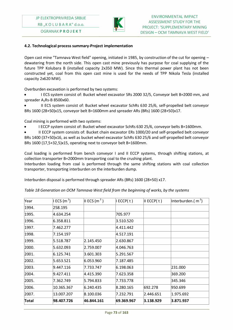
JP ELEKTROPRIVREDA SRBIJE
RB „K O L U B A R A“ d.o.o.
OGRANAK P R O J E K T
ENVIRONMENTAL IMPACT ASSESSMENT STUDY FOR THE
PROJECT: ‘SUPPLEMENTARY MINING DESIGN – OCM TAMNAVA WEST FIELD’
Page 73 of 163
4.2. Technological process summary-Project implementation
Open cast mine "Tamnava West field" opening, initiated in 1985, by construction of the cut for opening – dewatering from the north side. This open cast mine previously has purpose for coal supplying of the future TPP Kolubara B (installed capacity 2x350 MW). Since this thermal power plant has not been constructed yet, coal from this open cast mine is used for the needs of TPP Nikola Tesla (installed capacity 2x620 MW). Overburden excavation is performed by two systems: I ECS system consist of: Bucket wheel excavator SRs 2000 32/5, Conveyor belt B=2000 mm, and spreader A2Rs-B 8500x60.
II ECS system consist of: Bucket wheel excavator SchRs 630 25/6, self-propelled belt conveyor BRs 1600 (28+50)x15, conveyor belt B=1600mm and spreader АRs (BRs) 1600 (28+50)x17. Coal mining is performed with two systems: I ECCP system consist of: Bucket wheel excavator SchRs 630 25/6, conveyor belts B=1600mm.
II ECCP system consists of: Bucket chain excavator ЕRs 1000/20 and self-propelled belt conveyor BRs 1400 (37+50)x16, as well as bucket wheel excavator SchRs 630 25/6 and self-propelled belt conveyor BRs 1600 (17,5+32,5)x15, operating next to conveyor belt B=1600mm. Coal loading is performed from bench conveyor I and II ECCP systems, through shifting stations, at collection transporter B=2000mm transporting coal to the crushing plant. Interburden loading from coal is performed through the same shifting stations with coal collection transporter, transporting interburden on the interburden dump. Interburden disposal is performed through spreader АRs (BRs) 1600 (28+50) x17. Table 18 Generation on OCM Tamnava West field from the beginning of works, by the systems Year I ECS (m 3) II ECS (m 3 ) I ECCP( t ) II ECCP( t ) Interburden.( m 3)
1994. 258.195
1995. 4.634.254 705.977
1996. 6.358.811 3.510.520
1997. 7.462.277 4.411.442
1998. 7.154.197 4.517.191
1999. 5.518.787 2.145.450 2.630.867
2000. 5.632.093 2.759.007 4.046.763
2001. 6.125.741 3.601.303 5.291.567
2002. 5.653.521 6.053.960 7.187.485
2003. 9.447.116 7.733.747 6.198.063 231.000
2004. 9.427.411 4.415.390 7.623.358 369.200
2005. 7.362.749 5.794.833 7.733.778 345.346
2006. 10.365.367 6.240.435 8.280.165 692.278 950.699
2007. 13.007.207 8.100.036 7.232.791 2.446.651 1.975.692
Total 98.407.726 46.844.161 69.369.967 3.138.929 3.871.937

JP ELEKTROPRIVREDA SRBIJE
RB „K O L U B A R A“ d.o.o.
OGRANAK P R O J E K T
ENVIRONMENTAL IMPACT ASSESSMENT STUDY FOR THE
PROJECT: ‘SUPPLEMENTARY MINING DESIGN – OCM TAMNAVA WEST FIELD’
Page 74 of 163
In mid- 2009, transport of the new machinery is expected from the erection yard to the II ECS system, as well as the assembly of new conveyor with belts B=2000 mm. From mid- 2009 II ECS system will consist of: Bucket wheel excavator SchRs 1600 25/3, conveyor with belts B=2000mm, and spreader A2Rs-B 8500x60.
Machinery operating at II ECS system will pass to the II ECCP system, instead of bucket wheel excavator SchRs 630 25/6 and self-propelled belt conveyor BRs 1600 (17,5+32,5)x15, which are intended for OCM Veliki Crljeni. Former spreader АRs (BRs) 1600 (28+50) x17 will be operating as self-propelled belt conveyor at the I ECCP system.
Table 19 Coal production dynamics, overburden and interburden excavation and coal quality 2008-2012
Vertical division to benches in accordance with coal homogenization possibilities
Depending on the overburden possibilities, overburden and coal geotechnical characteristics, as well as technological possibilities of the available equipment for the massive exploitation, vertical division of deposit is performed.
Two benches are designed at the overburden i.e., two ECS systems. Both of systems will have one bucket wheel excavator. At the I ECS system, bucket wheel excavator SRs 2000 32/5 + VR will be operating. At the II ECS system, until mid- 2009, bucket wheel excavator SchRs 630 25/6 will be operating together with self-propelled belt conveyor BRs1600 (28+50) x15. From mid- 2009, II ECS system will have in operation bucket wheel excavator SchRs 1600 25/3 (from the erection yard). Their characteristics enable overburden excavation up to the coal series. Vertical division is shown at Figure 17.
For coal series excavation, two benches are also designed, i.e., two ECCP systems. At the I ECCP system bucket wheel excavator SchRs 630 25/6, and at the II ECCP system bucket wheel excavator SchRs 630 25/6 with BRs 1600 (17.5+32.5) x15 and bucket chain ERs 1000/20 with BRs 1400 (37+50) x16 will be in operation.
Overburden removal on the I ECS system will be done with a spreader A2Rs-B 8500x60 in above-level and below-level operations. A cassette will be formed in above-level blocks for gypsum, slag, ash and carbonate coal (by-products of the future TPP Kolubara B).
Overburden removal on the II ECS system will be done with a spreader ARs (BRs) 1600 (28+50) x 17 until mid-2009. From mid-2009, a new spreader A2Rs 8500x60 will be introduced into the II ECS system (from the erection yard).
The amount of interburden in coal seams will considerably increase starting from mid-2008. Dumping of interburden will be done with spreaders ARs (BRs) 1600 (28+50) x 17 in below-level operation to the floor seam in the eastern part of the open cast mine. In 2010, dump site interburden conveyer will be
Year Overburden
m3 x 106
Coal
t x 106
Interburden
m3 x 106
Overburden total-
m3 x 106
Ко
m3 / t
Ку
m3 / t
Quality
W
%
P
%
DТЕ
кЈ/кг
2008. 20.5 14 3 23.5 1.46 1.68 49.9 10.9 8.119
2009. 19.5 13 3.9 23.4 1.5 1.8 51.3 12.8 7.572
2010. 24 12 3.3 27.3 2 2.28 51.2 13.2 7.493
2011. 24 12 3.5 27.5 2 2.29 47.7 17.2 7.339
2012. 24 12 3.4 27.4 2 2.28 45.1 18.2 7.666

JP ELEKTROPRIVREDA SRBIJE
RB „K O L U B A R A“ d.o.o.
OGRANAK P R O J E K T
ENVIRONMENTAL IMPACT ASSESSMENT STUDY FOR THE
PROJECT: ‘SUPPLEMENTARY MINING DESIGN – OCM TAMNAVA WEST FIELD’
Page 75 of 163
placed on the floor seam, while the spreader will be operating above and below-level, thus supporting dump site bench of the I and the II ECS systems.
Figure 16 Vertical divisions on overburden
Figure 17 Vertical divisions on coal and interburden
Technological scheme of coal and overburden excavation, and overburden removal is shown at Figure 18.
Percentage ratio of interburden and coal by slopes at the west part of the open cast mine is shown at Table 20.
Table 20 Percentage ratio - coal-overburden – west
Excavator Overburden (%) Coal (%)
SchRs 630 (1) 39 61
SchRs 630 (2) 80 20
SchRs 630 (3) 64 36
ЕRs 1000 7 93
Table 21 Percentage ratio - coal-overburden – east
Excavator Overburden (%) Coal (%)
SchRs 630 (1) 30 70
SchRs 630 (2) 70 30
SchRs 630 (3) 60 40
ERs 1000 10 90

JP ELEKTROPRIVREDA SRBIJE
RB „K O L U B A R A“ d.o.o.
OGRANAK P R O J E K T
ENVIRONMENTAL IMPACT ASSESSMENT STUDY FOR THE
PROJECT: ‘SUPPLEMENTARY MINING DESIGN – OCM TAMNAVA WEST FIELD’
Page 76 of 163
Figure 18 Technological scheme of coal and overburden excavation and overburden removal

JP ELEKTROPRIVREDA SRBIJE
RB „K O L U B A R A“ d.o.o.
OGRANAK P R O J E K T
ENVIRONMENTAL IMPACT ASSESSMENT STUDY FOR THE
PROJECT: ‘SUPPLEMENTARY MINING DESIGN – OCM TAMNAVA WEST FIELD’
Page 77 of 163
Mine dewatering
Protection task of open cast mine Tamnava West field, against ground and surface waters is to provide, in accordance with mining activities dynamics, normal operation conditions, according to designed technology of excavation both coal and overburden transport, as well as disposal.
For the purpose of mine protection against ground and surface waters, standard dewatering facilities are applied: wells, channels, pipe lines, pumping stations, water collectors. Mine protection against ground waters in roof seam of coal series (alluvial and terrace gravels) is implemented by controlled water intake into the slope channels and by transported it to the water collectors. Mine protection against ground waters in sands is performed by construction of drainage channels with water collectors.
Mine protection against flood - Technical description of
Conceptually, protection of ground waters is treated like protection from:
a) Surface waters from surrounding area
b) Surface waters excreted directly into the mine operating area
Surface waters protection against surrounding catchment area
Mine protection against waters coming from surrounding area, from west and south-west side is performed by the existing peripheral channel, which extends along northwest side and west boundary of the mine. This channel has double function. Besides, collection of waters, coming from Kladnica retention, it performs water collection of all waters coming from the area, west from the channel. At the narrow area between the channel and mine border, water amounts creating due to precipitations are relatively at small level, so protection is implementing inside the mine borders.
Mine protection against waters coming from the south side is performing by retentions at Duboki Potok.
Part of water amount from this catchment area must be collected in the manner to make conditions for water collectors’ creation (BC-3 and BC-4). Water from those water collectors is transported to the retention Kladnica by pump system and pipe line.
Protection against surface waters directly excreted into the mine operating area
Water which during the precipitation excreted directly into the mine operating area gravitates towards the lowest points, in which case conditions for water collectors creation within floor seam (GVC and BC-1), are met. From these water collectors, water is pumped through pump systems and pipe lines into the retention Kladnica-old river bed of river Kladnica.
At the roof seam of the II coal seam there is a need for creation of water collectors BC-2. From this water collector water is pumped into the existing channel from the east side of the mine, and River Kolubara is the final recipient.
Details of dewatering facilities are given in Table 22.
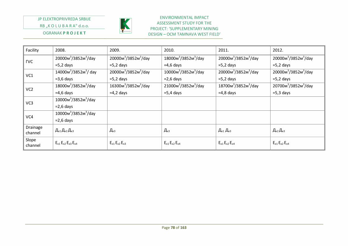
JP ELEKTROPRIVREDA SRBIJE
RB „K O L U B A R A“ d.o.o.
OGRANAK P R O J E K T
ENVIRONMENTAL IMPACT ASSESSMENT STUDY FOR THE
PROJECT: ‘SUPPLEMENTARY MINING DESIGN – OCM TAMNAVA WEST FIELD’
Page 78 of 163
Facility 2008. 2009. 2010. 2011. 2012.
ГVС 20000м3/3852м3/day
=5,2 days
20000м3/3852м3/day
=5,2 days
18000м3/3852м3/day
=4,6 days
20000м3/3852м3/day
=5,2 days
20000м3/3852м3/day
=5,2 days
VС1 14000м3/3852м3/ day
=3,6 days
20000м3/3852м3/day
=5,2 days
10000м3/3852м3/day
=2,6 days
20000м3/3852м3/day
=5,2 days
20000м3/3852м3/day
=5,2 days
VС2 18000м3/3852м3/day
=4,6 days
16300м3/3852м3/day
=4,2 days
21000м3/3852м3/day
=5,4 days
18700м3/3852м3/day
=4,8 days
20700м3/3852м3/day
=5,3 days
VС3 10000м3/3852м3/day
=2,6 days
VС4 10000м3/3852м3/day
=2,6 days
Drainage channel
Дк1 Дк2 Дк3 Дк3 Дк3 Дк1 Дк3 Дк2 Дк3
Slope channel
Ек1 Ек2 Ек3 Ек4 Ек1 Ек2 Ек3 Ек1 Ек2 Ек4 Ек1 Ек2 Ек4 Ек1 Ек2 Ек4
JP ELEKTROPRIVREDA SRBIJE
RB „K O L U B A R A“ d.o.o.
OGRANAK P R O J E K T
ENVIRONMENTAL IMPACT ASSESSMENT STUDY FOR THE
PROJECT: ‘SUPPLEMENTARY MINING DESIGN – OCM TAMNAVA WEST FIELD’
Page 79 of 163
Technical description of mine protection from ground waters
Based on detail analysis of natural conditions at the investigation area, it is been stated that the entire area is very complex in the manner of dewatering. Three hydro geological collectors are selected: roof, intermediate, floor seam.
Mine protection against ground waters of floor hydro geological collector
Dewatering
-Mine protection against ground waters of floor hydro geological collector in I zone abrupt dipping of floor sands (in two wells lines)
-Mine protection against ground waters of floor hydro geological collector in II zone abrupt dipping of floor sands (trenches)
Pre dewatering (in four well lines)
Mine protection against ground waters of intermediate hydro geological collector
Dewatering (in two well lines 1 and 2)
Pre dewatering (in well lines 3, 4, 5, 6)
Mine protection against ground waters of roof hydro geological collector
Dewatering (in well line 2)
Pre dewatering (in well line 3, 4, 5)
Mine protection from ground waters of roof hydro geological collector in the zone of retention Kladnica
A) Drainage of inner disposal site
B) Dewatering facilities, recipients:
-Drainage wells
-Dewatering trenches
-Water collectors and pumping stations
-Pipe lines
Note: Detail descriptions of Open cast mine Tamnava West field ground protection is given within Technical Project of Open cast mine Tamnava West field ground waters protection in the book I: Protection concept, developed by the Water management Institute "Jaroslav Cerni" 2008
Dumping facilities, crushing plants and coal lading facilities
Coal processing and preparation facility (crushing, storage, classing, and coal loading) are an integral part of energy complex Tamnava, built during construction of the mine Tamnava East field. It is located at north of open cast mines of Tamnava between two technological complexes –Tamnava East field and Tamnava West field, from one side, and TPP Nikola Tesla (future TE TO Kolubara B) from the other side. Transporters marked with SUP connect it with transporters marked with SU by which coal from open cast mines is transported.

JP ELEKTROPRIVREDA SRBIJE
RB „K O L U B A R A“ d.o.o.
OGRANAK P R O J E K T
ENVIRONMENTAL IMPACT ASSESSMENT STUDY FOR THE
PROJECT: ‘SUPPLEMENTARY MINING DESIGN – OCM TAMNAVA WEST FIELD’
Page 80 of 163
The facility has following tasks:
Receipt of coal from open cast mines Tamnava East field, Tamnava West field and in the future from the field Veliki Crljeni, South field
Distribution of run of mine coal on the dump, crushing and capture of lump coal for wider consumption
Run of mine coal crushing predicted for thermal power plant with size 100%-30 mm
Run of mine coal dumping for the purpose of undisturbed open cast mines operation in case of slowdown at the crushing plant and coal supplying of the crushing plant in the cease of slowdown at open cast mines
Dumping of crushed coal and storage to the bunkers and loading into wagons by which it is transported to the TPP Nikola Tesla facilities in Obrenovac, or TE TO Kolubara B
Capture of lump coal for the needs of wider consumption
Coal mass measurement
Capture of metal substances from coal directed towards thermal power plants.
In crushing facility there is developed sampling system for the purpose of coal quality control of delivered coal for thermal power plant. Quality if coal delivered for thermal power plant is examined at drive unit laboratory.
Work origination at the coal and overburden exploitation within coal processing
Table 23 Labor predicted by the Program from 1983
№ Working unit Number of employees
1. I ECS system 196 2. II ECS system 196 3. I ECLP system 213 4. II ECLP system 210 5. Preparatory works 335 6. Machine maintenance 175 7. Poor maintenance 117 8. Head office 125 Total 1567
Working systematization at the open cast mine Tamnava West field will keep its already existing structure with necessary reorganization for the purpose of work efficiency increase. The biggest change will be related to the equipment of maintenance system, for which is planned to be organized as unique for the entire west part of the basin.
Working regime at the open cast mine will be organized in three shifts by four –crew system. This kind of organization proved to be good, because it achieved higher time utilization of the equipment.
Organization at the open cast mine will be performed so the management and monitoring of generation processes will be directed by the same staff, while long term planning processes, financial economic, law, geologic divisions will be organized at the level of enterprise. (Open cast mines).

JP ELEKTROPRIVREDA SRBIJE
RB „K O L U B A R A“ d.o.o.
OGRANAK P R O J E K T
ENVIRONMENTAL IMPACT ASSESSMENT STUDY FOR THE
PROJECT: ‘SUPPLEMENTARY MINING DESIGN – OCM TAMNAVA WEST FIELD’
Page 81 of 163
Maintenance processes and processing, as well as coal quality will be jointly for mines which would operate in the west part of the basin (by 2008 Veliki Crljeni and Tamnava West field).
Total number of the employees is 768 at systems, plus 15 employees at SUP and SU line. Labor reduction could be reached by changing maintenance system, i.e., by centralizing of shift locksmiths and electricians, and creation of mobile intervention groups. Also, labor rationalization could be achieved by complete processes automation and by transporters modernization.
4.3. Raw materials and products
Consumption of standardized material (diesel fuel, gasoline, grease, various types of oil, electricity…) is defined based on long term monitoring of this material consumption on open cast mines of Kolubara mining basin, and achieved production, planned production increase and transportation length, as well as in comparison with achieved standards at the mine with similar capacity and overburden ratio – field D.
Hazardous substances balance is given in Study Annex.
More transporters will be engaged to ECS systems, due to front of activities extension, that is, transportation length will be extended, for about 3000 m per system. Regarding ECCP system, its length will be increased for three new transporters with length about 3000m.
Considering that there are some data on total consumption of standardized material on mines (grease, reducer oil, ropes) for 2002 and2003, calculation of material is done based on amount of spent material and achieved production. Electricity consumption norm is obtained based on technical characteristics of installed equipment (installed capacity), as well as based on consumption increase due to new consumers.
Data on diesel fuel and gasoline are given on the mine level, while norms are calculated based on achieved generation and experience designers data, as well as based on similar experiences from other open cast mines.
Table 24 Material norms and energy related to the coal production
№ Name of material Unit Norm on 1000 t Price (€/)
1 Reducer oil l 3,0 5.415
2 Other types of oil I 1,0 3 3 Grease kg 1,2 7.5 4 Diesel fuel I 70 0.9 5 Gasoline I 15 1.0 6 Electricity kWh 5500 0.05
7 Ropes kg 1,4 7.3 8 Cables kg 0,4 40 9 Rubber belt m 0,5 180 10 Spare parts kg 2,5 10

JP ELEKTROPRIVREDA SRBIJE
RB „K O L U B A R A“ d.o.o.
OGRANAK P R O J E K T
ENVIRONMENTAL IMPACT ASSESSMENT STUDY FOR THE
PROJECT: ‘SUPPLEMENTARY MINING DESIGN – OCM TAMNAVA WEST FIELD’
Page 82 of 163
11 Hangings material m6 1,0 1
12 Other supplies kg 2,8 4.25

JP ELEKTROPRIVREDA SRBIJE
RB „K O L U B A R A“ d.o.o.
OGRANAK P R O J E K T
ENVIRONMENTAL IMPACT ASSESSMENT STUDY FOR THE
PROJECT: ‘SUPPLEMENTARY MINING DESIGN – OCM TAMNAVA WEST FIELD’
Page 83 of 163
Table 24 Material norms and energy related to overburden production
№ Name of material Unit Norm on 1000 m3 Price(€/)
1 Reducer oil I 2.8 5.415
2 Other types of oil l 0.8 3 3 Grease kg 1.5 7.5 4 Diesel fuel I 100 0.9 5 Gasoline I 20 1.0 6 Electricity kWh 4500 0.05
7 Ropes kg 1.4 7.3 8 Cables kg 0.5 40 9 Rubber belt m 0.5 180 10 Spare parts kg 3.0 10
11 Hangings material m6 1.3 1
12 Other supplies kg 2.5 4.25
4.4. The way of natural recourses usage, especially non-renewable ones, or hardly renewable (land, water, mineral raw materials, stone, gravel, sand, forests, power and other, with observation on possible occupation of their areas
The issue of areas occupation necessary for the open cast mine development as well as all its contents necessary for coal mining functioning properly, is one of important parameters appropriate for defining the relation open cast mine-environment. This process is inevitable. Wide areas are mainly agricultural with lot of orchards, vineyards, meadows, forests, which will change their purpose. Natural recourses from this area are finding their use within various industrial areas.
4.5. Analysis of other project factors on the environment, with observation on the cumulative effect with already existing or planned activities on the location, analysis on possible or executed violation of environmental standards at the subject location
Development of intensive lignite mining at open cast mines of Kolubara Basin, as well as development of processing and thermal capacities based on that lignite, is responsible for strong industrial-economic development of Serbia in sixties and seventies, but simultaneously caused negative changes in each environmental segment of the subject area.

JP ELEKTROPRIVREDA SRBIJE
RB „K O L U B A R A“ d.o.o.
OGRANAK P R O J E K T
ENVIRONMENTAL IMPACT ASSESSMENT STUDY FOR THE
PROJECT: ‘SUPPLEMENTARY MINING DESIGN – OCM TAMNAVA WEST FIELD’
Page 84 of 163
Considering diversity and complexity of energy sector development, and environment protection for the past two decades, many studies and environment analyses were developed by the science institutions, universities, design organizations and experts, which primarily were directed on development issues of new thermal capacities construction, and their impacts on the environment. Besides that, many study-research studies were developed: cadastre of pollutants development, development of systematized environment monitoring. Those researches analyses indicated that it is possible to establish one integral informational system on the environment at OCM Kolubara area, but until today, that kind of system has not been established in practice. OCM Kolubara development improved social-economic area development. However, mining activities, and scope and efficiency of lignite utilization within mining complex of OCM Kolubara, are main sources of negative changes within environment, with certain effect at the wider environment. Basic ecological disorders at the subject area occurred under the influence of mining activities on natural eco systems, and especially on agricultural and forest eco systems. Open cast mining dynamics have progressively destroyed, during last 50 year, quality agricultural land which is above lignite deposits, simultaneously changing morphological, hydrological, and other space characteristics. Power-industry complex has an ecological dimension manifested as pollution of air, soil, surface and underground waters, thermal load of area, noise emissions… Mining-industrial development of area, encouraged development of settlements and infrastructure systems, but also created a conflict between mining and existing facilities located around open cast mining zone. Environment estimation is based on environment changes. Regarding analysis, relevant information on technological processes characteristics applied in MB Kolubara, including implemented environmental protection measures; measurements data on some environment parameters…
Besides open cast mines and TPPs, pollutants are also "Kolubara-Prerada", "Ksela Srbija", "Kolubara-Metal", "Kolubara-Univerzal".
"Kolubara-Prerada" – Vreoci is processing run of mine coal from open cast mines of field "D". That coal is designed for industry in wider consumption, as well as for supplying of TPPs.
Wet separation is processing about 3.000.000 t of coal per year. Technology includes processes of coal cleaning, drying, and coal classification. Overburden appears from these processes as waste product (about 300.000 t), which is transported to the dump, and also big amount of waste waters with high concentration level of organic and inorganic substances, transported to the water treatment facilities.
Drying plant is emitting about 410g/h H2S; 108g/h SО2; 23g/h NОH; 38g/h phenol; 1,82kg/h of solids.
Within "Kolubara-Prerada", plant generates heating energy (technological steam) which is necessary for drying plant driving unit and gas concrete, and it is used for industrial area circle; it has two steam generators, of total capacity of 140 t/h, and lignite consumption of 63, 2 t/h.
According to measurements results, heating plant is emitting into the air up to 42 kg/h of carbon monoxide, 298-322 kg/h of sculpture dioxide, 34-72 kg/h of nitrogen oxides, and 0,525-1,970 t/h of
solids. Flue gasses are led through electrostatic precipitator for ash capture ( %98 ), and afterwards through reinforced concrete stack 80 m height, diameter 3 m.
Ash and slug are mixed with water (1:8) and transported to the dump in Junkovac.
Waste water from thermal power plant is led to the water treatment facility.

JP ELEKTROPRIVREDA SRBIJE
RB „K O L U B A R A“ d.o.o.
OGRANAK P R O J E K T
ENVIRONMENTAL IMPACT ASSESSMENT STUDY FOR THE
PROJECT: ‘SUPPLEMENTARY MINING DESIGN – OCM TAMNAVA WEST FIELD’
Page 85 of 163
Besides the above mentioned, at processing plants, increased noise level is created. Presence of lightning arresters and radioactive bathometers can cause increased level of radioactivity in its surroundings.
Kolubara – Metal – Vreoci deals with the production, overhaul and erection of equipment and machinery for coal production and processing. It also has a foundry unit for grey sheet metal, silumine and bronze, with the installed capacity of 250 tons/a. The following pollutants are emitted from the dome furnace of the foundry unit: CО2, CО, SО2 and smoke, discharged into the atmosphere without any treatment through the stack 6 m high. Large amounts of solid waste is created in these operational units (steel, brass, aluminum waste, etc), sold for recycling. Waste waters coming from the foundry unit, contaminated with clay, sand and burnt remains of modeling mixture, are led together with sanitary waters to the central treatment plant. In addition to this, special separators for primary separation of oils and lubricants are also used. This company has three radioactive lighting arresters, which may represent a radiation hazard.
Kolubara – Univerzal – Veliki Crljeni consists of three operational units: raw rubber production, production of rubber-technical goods and production and regeneration of rubber belt conveyers. Annual installed capacities are 10.000 t of raw rubber, 750 t of rubber-technical goods and 90.000 m of belt conveyers. The production process is based on the classic rubber technology. This process is accompanied by air pollution with solid particles and steam and gases primarily coming from organic diluters. Sanitary waste waters are treated in ‘Biorol’ facility prior to their discharge into river Turija. Ionizing radiation sources are present in installed fire alarms. Solid waste consists of municipal waste and rubber waste.
Significant roads and railway are passing through this area: thoroughfare M-22 (Ibarska Magstrala) and M-4 (Valjevo-Lazarevac-Arandjelovac), railway Belgrade-Bar, and other regional and local roads and industrial local railway network.
In general, it can be assumed that this area is affected by negative present impacts of roads and traffic, at the following distances:
Air pollution - 500m
Water regime change – river course crossed by roads
Soil pollution – area can be directly affected by waste materials
Noise – at least 300m
Agriculture, flora, fauna – at least 300 m
Traffic accidents – at cross sections
Radioactive lightning arrests also could be kind of radioactive risk.
Environment estimation is based on environment changes. Regarding analysis, relevant information on technological processes characteristics applied in MB Kolubara, including implemented environmental protection measures; measurements data on some environment parameters… It can be stated that lignite production created negative direct consequences on the environment, which include:
Destruction and occupation of fertile agricultural land,
Change of morphological and landscape characteristics of the subject area,
Flood risks increase,
Water pollution and soil by waters from ash disposal sites, oil derivates, detergents, Inadequate disposal of industrial and communal solid waste

JP ELEKTROPRIVREDA SRBIJE
RB „K O L U B A R A“ d.o.o.
OGRANAK P R O J E K T
ENVIRONMENTAL IMPACT ASSESSMENT STUDY FOR THE
PROJECT: ‘SUPPLEMENTARY MINING DESIGN – OCM TAMNAVA WEST FIELD’
Page 86 of 163
Air pollution caused by dust from ash disposal sites and flue gasses from boiler rooms and vehicles
Increased noise and vibration level
4.6. Impacts, of products occurred during the project, on the environment
a) Air pollution
Air pollution by mineral dust; following potential pollution sources are identified:
Dry dust on active benches and surface (open cast mine, disposal site)
Belt conveyor route
Mining machinery and technological equipment on the open cast mine (excavator, loader, bulldozer…)
Air pollution by exhaust gases from motors of mining machines is performed by the following possible sources (CO, NOx, SO2):
Loader
Truck and bulldozer
b) Water pollution
Registered contaminating sources are:
Change of hydro geological and hydrological regime of exploitation area,
Precipitations coming to the deposit
During the exploitation of the subject project, there will be:
Technological waste waters
Precipitations
Sanitary waste waters at the mine
Open cast mining of coal deposit according to the technological characteristics of the process could cause changes of hydro geological and hydrological regime of the wider area, and also harmful substances emission into the ground and surface waters.
Specified impacts of the mining activities on the ground water regime could cause ground water quality deterioration, due to harmful substances discharge from the open cast mine, overburden dump and workshops. In some extreme cases, well may dry up. In those cases it is necessary to construct new and deeper wells or an alternative water supply system.
Besides already mentioned impacts on hydro geological network, it is possible to point out negative impact due to the surface waste waters contamination from the mining workshops.
Based on river Kolubara characteristics (an average flow during the year), as well as based on estimated water amounts to be pumped into it, it can be concluded that pumped water amount are at small level compared with river itself water amount. Its quality would not be significantly depending on waste water quality, because it will come to their dilution.

JP ELEKTROPRIVREDA SRBIJE
RB „K O L U B A R A“ d.o.o.
OGRANAK P R O J E K T
ENVIRONMENTAL IMPACT ASSESSMENT STUDY FOR THE
PROJECT: ‘SUPPLEMENTARY MINING DESIGN – OCM TAMNAVA WEST FIELD’
Page 87 of 163
In accordance with adopted technological process of lignite open cast mining at OCM "Tamnava West field" it may be stated that waste water from technological process, which would be pumped into river Kolubara, will not have any impact on its quality.
Some of possible threats which may happen by using water supply and sewage system installations are as follows:
For water supply system
Unhygienic water supply sources
Out of order installation
Possibility of pollution due to manhole of the sewage system
Unexamined water supply network under necessary pressure
Application of the inappropriate installations material
For sewage system
Insufficient sewage inclination
Inappropriate sewage management
Insufficient number of ventilation channels
Incorrect material choice
Inappropriate dimensioning of the sewage system
Inappropriate selection and disposition of revision and manholes
For sanitary and sewage waters for sanitary facilities and for employees on the subject location, an appropriate septic tank will be construction, which, when it is needed, be emptying by JKP of municipality of Lazarevac.
Following measures in order to protect sewage and water supply system are:
For water supply system
Supplying sources must be hygienic
Water supply installation need to be clean, correct and chlorinated
Water supply system must be examined under defined pressure
Material for water supply installation must be of standardize quality with appropriate installation
For sewage system
Sewage inclinations must be sufficient
Dimensioning of the system must be correct and appropriate implemented
Material for water supply installation must be of standardize quality with appropriate installation measures
Selection and manholes disposition must be performed correctly
v)Soil pollution

JP ELEKTROPRIVREDA SRBIJE
RB „K O L U B A R A“ d.o.o.
OGRANAK P R O J E K T
ENVIRONMENTAL IMPACT ASSESSMENT STUDY FOR THE
PROJECT: ‘SUPPLEMENTARY MINING DESIGN – OCM TAMNAVA WEST FIELD’
Page 88 of 163
The issue of ratio open cast mine-environment is defined by relations occurred within the field of environmental protection. Technological process of lignite mining at OCM Tamnava West field cusses a change, that is, degradation of morphological terrain structure and hazardous substances capture into the environment, with certain concentration.
Base on consideration and analyses of designed and projected mining activities, predicted by this project, it is possible to perform lignite mining impacts on OCM Tamnava West field having on the soil. The main impact is regarding to the upper structure deterioration during mining activities. Specified negative impact may appear as consequence of upper seam excavation and its inadequate disposal, as well as the consequence of mixing upper seam with lower and other infertile materials.
The issues of occupation of the areas necessary for open cast mine development as well as for all accompanying parts necessary for coal mining operation, presents one of the important parameters for relations between open cast mine and environment.
At the observed area there is no possibility for soil pollution by oil derivates, because operation process has predicted limited amount for mining, loading, transport and auxiliary machines, completely in accordance with legal regulations.
g) Noise and vibration level
Possibility of negative impact of noise in working environment exists in several mining phases on open cast mines. Noise sources are mining machines for excavation, transport and auxiliary activities: excavators, loaders, bulldozers, belt conveyors, trucks.
Noise level estimation indicates that there will not be significant noise impact from technological process of coal excavation, because noise levels do not exceed permitted values, which are for example, for business-residential area, in IV zone, is 50-60 dB. This means that, condition of minimum of necessary distance of open cast mine, from the nearest residential facilities, is met.
Noise created on the open cast mine, will mainly affect employees at the place of activities implementation. Appropriate protection measures must be taken, in order to prevent negative impact which may be on the employees.
At the terrain where Tamnava West field deposit is located, significant vibrations are not expected, because the lignite mining is performed by the system of continual activity of bucket wheel excavator-conveyor belt. Vibration risks could only be found in some certain phases of machines operation and it is related to working environment only.
4.7. Project impact on availability or sufficiency of natural recourses (fossil fuels, ground waters, mineral raw materials, stone, sand gravels, forests…)
Supplementary mining project of OCM "Tamnava West field" extension has positive impact on availability and sufficiency of natural recourses, fossil fuels, ground waters, mineral raw materials, stone, sand gravels)
4.8. Direct project impact on human’s health
Coal dust and noise are main risks on human’s health caused by mining activities. Study results indicate that functioning of OCM Tamnava West field will not have significant impact on human’s health in close surrounding, while it may have impact on health of the people employed on the mine.

JP ELEKTROPRIVREDA SRBIJE
RB „K O L U B A R A“ d.o.o.
OGRANAK P R O J E K T
ENVIRONMENTAL IMPACT ASSESSMENT STUDY FOR THE
PROJECT: ‘SUPPLEMENTARY MINING DESIGN – OCM TAMNAVA WEST FIELD’
Page 89 of 163
Coal dust impact on the respiratory system, depends on free SiO2 content in coal dust, concentration…High level of SiO2 content (2%-25%) indicates that coal dust may have an impact on the people employed in the mine.
Over-exposure to the increased noise emission could lead to the worst health status.
Besides coal dust and noise, there are other health risks related to the mining activities: accidental injuries, fire risk, physical and chemical risks, as well as electric shock risk.
5. THE OVERVIEW OF MAIN ALTERNATIVES CONSIDERED BY THE EMPLOYER
5.1 Alternative location or route
During planning and designing process of open cast mining of mineral raw deposits there is no dilemma related to the choice of location, or consideration possibility of alternative solutions, because the location of the open cast mine is in exploitation function of the subject mineral raw material deposit. Alternatives exist, but not in domain of location itself.
Deposit is characterized by good transport conditions and communication connections. Near the deposit are located thoroughfares Belgade-Cacak-Podgorica, Belgrade-Celije-Valjevo-Zvornik, regional roads Lazarevac-Arandjelovac-Kragujevac and Valjevo-Ub-Obrenovac, as well as the rail way with standard gauge Belgrade-Bar.
In its close surroundings there is electrified industrial gauge Vreoci-Veliki Crljeni-Obrenovac.
Strategic alternatives
Project development of Tamnava West is directly related to the power plant requests for lignite coal, and primarily, for its delivery it is connected to the TPP Kolubara B facilities. No strategic alternatives will be possible if power plant Kolubara B would not be constructed and supplied with lignite coal.
Feasibility Study of coal supplying in Serbia is developed by DTM in January, 2002. It analyzed three mining areas and based on these analyses, it was concluded that mine Tamnava West is one of the most appropriate and economically the most eligible mine, which can supply power generation in Serbia during following years.
5.2. Alternative technological procedure
Selection of development technical alternatives of Tamnava West field also have been estimated and final alternative is given for the Mine as Annex 3, named Alternatives.
Some of coal quality improvement aspects are given bellow:
1. Mine dewatering
Estimation of the measures for water level reduction inside the mine, have identified needs for application of detail hydro meteorological mine model, and based on ground water regime, adoption of the most appropriate technical solution.
2. Coal quality

JP ELEKTROPRIVREDA SRBIJE
RB „K O L U B A R A“ d.o.o.
OGRANAK P R O J E K T
ENVIRONMENTAL IMPACT ASSESSMENT STUDY FOR THE
PROJECT: ‘SUPPLEMENTARY MINING DESIGN – OCM TAMNAVA WEST FIELD’
Page 90 of 163
Coal quality, its calorific value, depends on amount of ingredients which are present within excavated material, from the other hand, depends on coal deposit geological structure at any other location. Several options for maximum increase of coal quality are been examined, including selective mining and technical separations.
5.3. Managing with waste substances created during project implementation
Secondary raw materials
Material which is being captured from the coal is often raw material for itself, although has lower values than coal itself.
Table 26 Secondary raw material
Material Possible use
Contents of wet separation, grain size 150mm+0mm
Fuel, depending on coal content
Material obtained by waste water treatment Fuel in construction, artificial fertilization for bio products
Coal obtained by waste waters discharged through dryer, range -5+0
Brickets production
Slug obtained as the result of waste material burning
Roads construction
Ash and slug as the result of coal combustion in thermal power plants
Addition of minerals for cement production
Clay, gravels Raw material in construction, glass industry, food industry, as filters…
6. DESCRIPTION OF POSSIBLE SIGNIFICANT PROJECT IMPACTS ON THE ENVIRONMENT AN PEOPLES HEALTH
6.1. Analysis on direct, indirect, secondary, cumulative, short-mid-long term, constant, occasional, temporary, and negative environmental impacts
Each activity in the area brings certain changes and negative impacts in the manner of disturbance of natural balance. Open cast mines are specific industrial facilities which cannot be located based on legal and technical requests and parameters. They are developed, opened, in the area where mineral raw material deposits cannot be allocated. They may be located on high quality soil, near settlements, in zones interested for tourism, in nature protected areas, even in national parks. That is the reason why activities like investigation, planning and designing, even excavation itself, may appear as significant issues within field of preservation and environmental protection. Environmental protection at the area of large facilities and complex power systems presents one of the most important social problems.

JP ELEKTROPRIVREDA SRBIJE
RB „K O L U B A R A“ d.o.o.
OGRANAK P R O J E K T
ENVIRONMENTAL IMPACT ASSESSMENT STUDY FOR THE
PROJECT: ‘SUPPLEMENTARY MINING DESIGN – OCM TAMNAVA WEST FIELD’
Page 91 of 163
Technology of lignite open cast mining with its characteristics presents environmental pollution source. Successfully solution in the field of environmental protection includes round consideration and defining of all potential impacts. Obligation of all possible impacts defining is always placed as priority against basic ecological categories: air, water, soil, climate, flora, fauna, landscape…
In accordance with its duration, harmful impacts consist of:
Short term harmful impacts
Long term harmful impacts
Permanent harmful impacts
Short term harmful impacts are those which can be removed in the period of 2 years. They include: devastation of low growth, temporary roads construction, dumps, deposits, placing of temporary assembly facilities…
Long term harmful effects include those which are lasting while mining activities are lasting. Removal of these impacts must be implemented in combined way, with dominant human factor. This group covers: microclimate change, lumbering…
Permanent harmful impacts are characteristic for ore excavation.
Boundaries between short, long terms and permanent changes are not clearly expressed and depend on human’s activity on their rehabilitation. Otherwise, short ones can become long term, and long term can become permanent harmful impacts.
Considering the subject Project and all the above mentioned, it is necessary to perform Environmental Impact Assessment of the Project and define objectives of environmental quality management, in which case, the Employer and also local community will have benefit from.
6.2. Identification of possible pollution causes and degradation
Analysis and estimation of the existing environmental state, as well as evaluation of possible ecological risks which are a consequence of lignite open cast mine development, indicate that quantification of possible consequences may be achieved through detailed analysis of lignite mining impacts on the environment.
Possible impacts identification presents analysis of relation open cast mine-environment where all relevant facts for selection of lignite open cast mining technology may be defined based on basic ecological potential of analyzed area and basic relations within the system emission-transmission-imission-impact.
Recent experiences are defining impact matrix, in which case it is important to know that this matrix is spatial and timely variable category. Each impact needs to be quantified followed by verified data.
For the purpose of quantification of each impact and its significance, it is necessary to join indicators for concrete conditions, representing indicators of the exact size which, later are used in estimation processes.

JP ELEKTROPRIVREDA SRBIJE
RB „K O L U B A R A“ d.o.o.
OGRANAK P R O J E K T
ENVIRONMENTAL IMPACT ASSESSMENT STUDY FOR THE
PROJECT: ‘SUPPLEMENTARY MINING DESIGN – OCM TAMNAVA WEST FIELD’
Page 92 of 163
Figure 19 Criteria matrix – relation open cast mine "Tamnava West field" – environment
Within this study research, considering each specific characteristics, basic criteria are brought to the certain indicators, in order for existing relations to be quantified and defined.
Relations definition and impact assessment of open cast mining to the environment may be possible to achieve, only in case if each of specified criteria (figure 19) would be analyzed within concrete spatial relations and quantification procedure. This presents the way of conditions creation which is leading to the optimal technical solution.
Level of information, related to the existing relations and technological processes elements of exploitation, establishes possibility of analysis only within characteristics spatial entity.
Following facilities will be covered by analysis of potential pollution sources:
Open cast mine
Inside mining deposit
Each potential pollutant within mining complex is analyzed through categories defined by integral pollutants register.
Landscape characteristic
s.
Soli
Water
Air quality
Noise, vibrations,
heat and radiations
Natural and cultural assets
assets
Area purpose
Separation of the space
Health impacts
Infrastructure
Social-economic impacts
Meteorologic
al parameters and climate
клима
Population and
migration.
Eco system
OCM Tamnava
West field

JP ELEKTROPRIVREDA SRBIJE
RB „K O L U B A R A“ d.o.o.
OGRANAK P R O J E K T
ENVIRONMENTAL IMPACT ASSESSMENT STUDY FOR THE
PROJECT: ‘SUPPLEMENTARY MINING DESIGN – OCM TAMNAVA WEST FIELD’
Page 93 of 163
6.3. Impact analysis on geology and geo morphology
Mining activities impact on geological structure may be classified as follows:
-loss of geological formations within areas of intervention and joint geological information,
-Activation and changing of geo chemical information,
-Creation of new geological formations by mixing of soil material with different quantities and qualities,
-Material amounts reduction due to coal excavation and ash and slug disposal into free space of the mine,
-Changes within geo morphology of the entire mining area (topography, drainage and vegetation).
6.4. Impact analysis on air quality
Mineral dust is one of significant potential hazard for the air, whose emission value in certain natural conditions could be above permitted level prescribed for settled areas.
Characteristic air pollution sources by suspended particles are: point (excavator, loader), linear (roads on open cast mines, belt conveyors) and surface (active areas on the open cast mine and disposal site).
Primary sources are mining machinery and technological equipment in operation, and secondary sources are all active areas, which under the wind impact emit floating fraction from sediment dust.
Total intensity of air pollution depends on the meteorological conditions, which means that sometimes in dry periods may present potential air pollutant within active area.
Emission sources of suspended particles are given within Table 27
Table 27
Source Type of source
Тачкасти
Тачкасти
Тачкасти
Тачкасти
Тачкасти
Линијски
Површински
Тачкасти
Линијски
Поршински
Material Activities description
Exploration drilling set point
Overburden Deposit exploration
Bucket wheel excavator point
Coal, overburden
Coal and overburden mining
Shifting station point
Coal, overburden
Transport system for coal and overburden
Spreader point
Overburden Overburden dump
Bulldozer point
Coal, overburden
Train of material at disposal site and benches
Conveyor belt linear
Coal, overburden
Transport system for coal and overburden
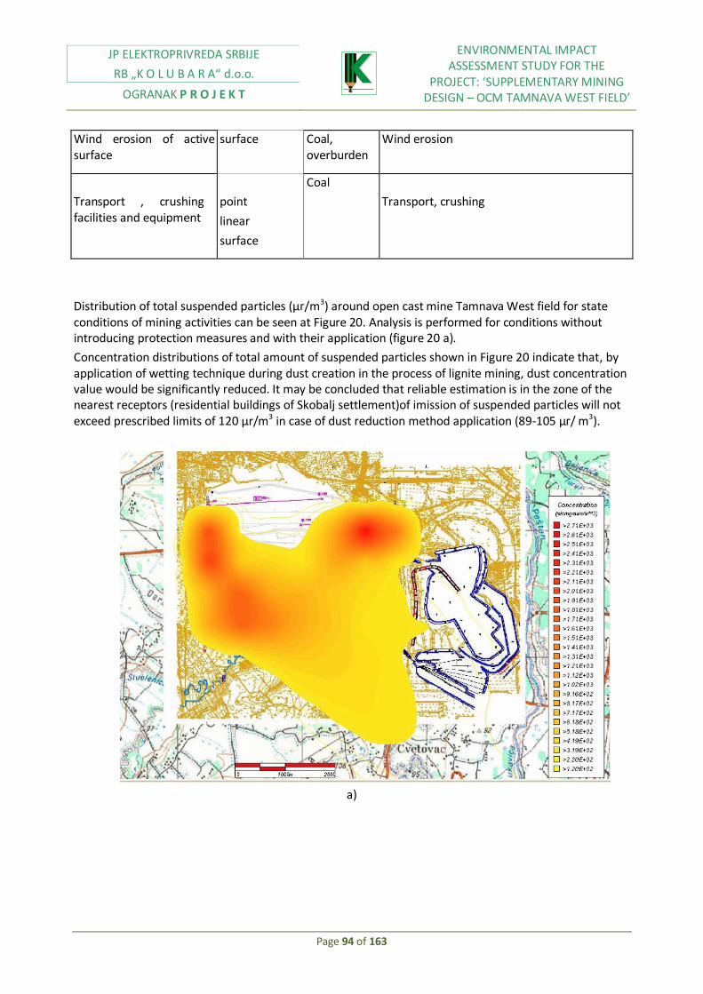
JP ELEKTROPRIVREDA SRBIJE
RB „K O L U B A R A“ d.o.o.
OGRANAK P R O J E K T
ENVIRONMENTAL IMPACT ASSESSMENT STUDY FOR THE
PROJECT: ‘SUPPLEMENTARY MINING DESIGN – OCM TAMNAVA WEST FIELD’
Page 94 of 163
Wind erosion of active surface
surface
Coal, overburden
Wind erosion
Transport , crushing facilities and equipment
point
linear
surface
Coal
Transport, crushing
Distribution of total suspended particles (μг/m3) around open cast mine Tamnava West field for state conditions of mining activities can be seen at Figure 20. Analysis is performed for conditions without introducing protection measures and with their application (figure 20 a).
Concentration distributions of total amount of suspended particles shown in Figure 20 indicate that, by application of wetting technique during dust creation in the process of lignite mining, dust concentration value would be significantly reduced. It may be concluded that reliable estimation is in the zone of the nearest receptors (residential buildings of Skobalj settlement)of imission of suspended particles will not exceed prescribed limits of 120 μr/m3 in case of dust reduction method application (89-105 μг/ m3).
a)

JP ELEKTROPRIVREDA SRBIJE
RB „K O L U B A R A“ d.o.o.
OGRANAK P R O J E K T
ENVIRONMENTAL IMPACT ASSESSMENT STUDY FOR THE
PROJECT: ‘SUPPLEMENTARY MINING DESIGN – OCM TAMNAVA WEST FIELD’
Page 95 of 163
b)
Figure 20.Distribution of suspended particles concentration (μг/м3) around open cast mine in conditions of north-west wind blowing without (a) and with (b) application of dust protection method
a)

JP ELEKTROPRIVREDA SRBIJE
RB „K O L U B A R A“ d.o.o.
OGRANAK P R O J E K T
ENVIRONMENTAL IMPACT ASSESSMENT STUDY FOR THE
PROJECT: ‘SUPPLEMENTARY MINING DESIGN – OCM TAMNAVA WEST FIELD’
Page 96 of 163
b)
Figure 21.Distribution of suspended particles concentration (μг/м3) around open cast mine in conditions of sought-east wind blowing without (a) and with (b) application of dust protection method
Distribution of total suspended particles concentration showed in Figure 21, indicate that significant dust impact at the area of works implementation at the open cast mine, may be expected. Contour- lines, of total suspended particles concentration shown at Figure 21, indicate that by application of wetting technique during dust reduction within lignite mining process at the OCM Tamnava West field, values of dust concentration would be significantly reduced.
If dust reduction technique at the subject mine in zone of Radljevo would be applied, it may be expected that suspended particles concentration (118-285 μг/м3) would not exceed limit value amounting to 120 μг/м3.
Potential danger of air pollution in the function of dispersed small dust fraction is presented by facilities and equipment for crushing, classing and coal dumping. Distribution of total suspended particles concentration (μг/м3) located around coal preparation and processing plant within conditions of west wind blowing, is shown at the Figure 22 a). Analysis is performed for facility conditions of 8 pollution sources: 1 surface (coal dump) 1 linear (SUP) and 6 point (shifting points, facilities, loading into the wagons).
Suspended particles distribution (μг/м3) around coal preparation and processing plant within conditions of west wind blowing with dust reduction technique is shown at the Figure 22 b).
Contour lines of suspended particles shown at figures 22 a) and b) clearly indicate that by application of wetting technique during dust reduction in coal preparation and processing, dust concentration would be reduced. It is necessary to point out that if dust reduction technique would not be used, it may be expected that concentration of total suspended particles to be amounting over 200 μг/м3 (figure 22 a), which exceeds limit value of 120 μг/м3.

JP ELEKTROPRIVREDA SRBIJE
RB „K O L U B A R A“ d.o.o.
OGRANAK P R O J E K T
ENVIRONMENTAL IMPACT ASSESSMENT STUDY FOR THE
PROJECT: ‘SUPPLEMENTARY MINING DESIGN – OCM TAMNAVA WEST FIELD’
Page 97 of 163
Air pollution by exhaust gasses from motors of mining machines is performed by the following possible sources: CO, NOx, SO2. Pollutants like exhaust gasses at lignite open cast mines with continuous mining technology present small pollution sources, compared with its emission intensity, and they are not marked as significant environmental pollutants. It has been estimated that impact zones has local character and they are only active within small area, most commonly inside excavated space (in the working environment).

JP ELEKTROPRIVREDA SRBIJE
RB „K O L U B A R A“ d.o.o.
OGRANAK P R O J E K T
ENVIRONMENTAL IMPACT ASSESSMENT STUDY FOR THE
PROJECT: ‘SUPPLEMENTARY MINING DESIGN – OCM TAMNAVA WEST FIELD’
Page 98 of 163
Figure 22 Distribution of total suspended particles concentration (μг/м3) around crushing plant and coal dump in conditions of north-west wind blowing without (a) and with (b) application of dust protection method
6.5. Noise impact analysis
Possibility of appearance of negative noise impact in working environment exists in each exploitation phase on open cast mines. Main noise sources are mining machines: loaders, excavators, bulldozers, conveyor belts, trucks. Table 28 implies noise levels of some equipment types at open cast mines, in accordance with long term measurements performed by Ventilation and technical protection department of Mining faculty, Belgrade University.
Table 28 Noise levels during equipment operation
Equipment type
Bu
cket
w
hee
l ex
cava
tor
Bu
cket
w
hee
l
exca
vato
r-ca
bin
Dra
glin
e
Spre
ader
Co
nve
yor
bel
t
Bu
lldo
zer
Veh
icle
s w
ith
die
sel e
ngi
nes
Noise level (dB)
92-94 78 82 85-89 96-102 115 110

JP ELEKTROPRIVREDA SRBIJE
RB „K O L U B A R A“ d.o.o.
OGRANAK P R O J E K T
ENVIRONMENTAL IMPACT ASSESSMENT STUDY FOR THE
PROJECT: ‘SUPPLEMENTARY MINING DESIGN – OCM TAMNAVA WEST FIELD’
Page 99 of 163
Figure 23 Noise level estimation around OCM Tamnava West field for mining activities reduction
Noise level estimation for receptors having distance of 1000 m from the open cast mine in settlements Radljevo and Skobalj (figure 23) implies that noise significant impact from technological excavation process may not be expected, because noise levels do not exceed permitted values, which are 50-60 dB for residential zone. This implies to met conditions of minimum needed distance of open cats mine from the nearest residential facilities in function of noise protection.
Noise created by mining activities mainly will affect employees at their working places within activities implementation. Figure 24 implies noise level estimation coming from mining activities related to coal processing at crushing plant. Noise sources have been analyzed: coal processing facilities, shifting stations, spreader, and loader.
Noise level estimation for receptors, having distant of 1000 m from the open cast mine in settlement Cvetovac-Sumedj (figure 24) implies that significant impact of noise from technological excavation process may not be expected, because noise levels do not exceed permitted values, which are 50-60 dB for residential zone. This implies to met conditions of minimum needed distance of open cats mine from the nearest residential facilities in function of noise protection.
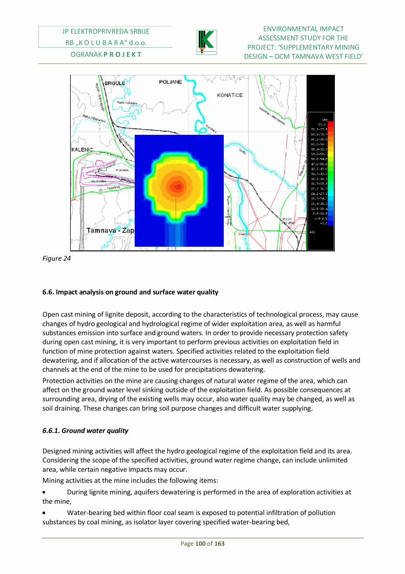
JP ELEKTROPRIVREDA SRBIJE
RB „K O L U B A R A“ d.o.o.
OGRANAK P R O J E K T
ENVIRONMENTAL IMPACT ASSESSMENT STUDY FOR THE
PROJECT: ‘SUPPLEMENTARY MINING DESIGN – OCM TAMNAVA WEST FIELD’
Page 100 of 163
Figure 24
6.6. Impact analysis on ground and surface water quality
Open cast mining of lignite deposit, according to the characteristics of technological process, may cause changes of hydro geological and hydrological regime of wider exploitation area, as well as harmful substances emission into surface and ground waters. In order to provide necessary protection safety during open cast mining, it is very important to perform previous activities on exploitation field in function of mine protection against waters. Specified activities related to the exploitation field dewatering, and if allocation of the active watercourses is necessary, as well as construction of wells and channels at the end of the mine to be used for precipitations dewatering.
Protection activities on the mine are causing changes of natural water regime of the area, which can affect on the ground water level sinking outside of the exploitation field. As possible consequences at surrounding area, drying of the existing wells may occur, also water quality may be changed, as well as soil draining. These changes can bring soil purpose changes and difficult water supplying.
6.6.1. Ground water quality
Designed mining activities will affect the hydro geological regime of the exploitation field and its area. Considering the scope of the specified activities, ground water regime change, can include unlimited area, while certain negative impacts may occur.
Mining activities at the mine includes the following items:
During lignite mining, aquifers dewatering is performed in the area of exploration activities at the mine,
Water-bearing bed within floor coal seam is exposed to potential infiltration of pollution substances by coal mining, as isolator layer covering specified water-bearing bed,

JP ELEKTROPRIVREDA SRBIJE
RB „K O L U B A R A“ d.o.o.
OGRANAK P R O J E K T
ENVIRONMENTAL IMPACT ASSESSMENT STUDY FOR THE
PROJECT: ‘SUPPLEMENTARY MINING DESIGN – OCM TAMNAVA WEST FIELD’
Page 101 of 163
Partial ground water aquifer dewatering is performed by lignite mining and open cast mine dewatering,
As the consequence of heterogonous material disposal in spaces where mining activities are terminated, new long term hydrological and hydro geological conditions are created at the area of the open cast mine.
Open cast mining of coal deposit according to the technological characteristics of the process could cause change of hydro geological and hydrological regime of the wider area and also harmful substances emission into the ground and surface waters.
Specified impacts of the mining activities on the ground water regime could cause ground water quality deterioration due to harmful substances discharge from the open cast mine, overburden dump and workshops. In some extreme cases, well may dry up. In those cases it is necessary to construct new and deeper wells, or, an alternative water supply system.
Analyzed area is subject to the activities which significantly change ground water regime, degradation of local sources may occur. The only one reliable and long term solution is connection of all settlements within the zone affected by mining activities, on the regional water supply system.
6.6.2. Surface water quality
Hydrological regime at Tamnava West field area will be significantly affected and changed by planned mining activities. Diversion of the river would not be based on natural gravitation water course, but on the pumps, which will take water from new reservoir (which is planned), west of the mine, into the new water course of river Kladnica (figure 25). Beside river Kladnica diversion, suggested activities request Duboki potok removal, with bigger part of its catchment area.
Main consequences of river diversion are:
Creation of artificial river by constant pumping for its water course,
Extensive construction works, necessary for reservoir creation and loss of the existing back log soil, which be under the water after activities were completed,
Disappearance of the coastal settlements along river Kladnica
Beside already mentioned impacts, it is possible to allocate few more potential negative impacts on surface water quality:
Discharge of untreated waters from administrative facilities of Tamnava West (and East) field. Existing water treatment facility is not in function.
Contamination of surface waters by waste waters from mining auxiliary activities (workshops)
Contamination of surface waters by waste waters from ash disposal sites from the future power plant Kolubara B, whose disposal is designed within open cast mine Tamnava West field.

JP ELEKTROPRIVREDA SRBIJE
RB „K O L U B A R A“ d.o.o.
OGRANAK P R O J E K T
ENVIRONMENTAL IMPACT ASSESSMENT STUDY FOR THE
PROJECT: ‘SUPPLEMENTARY MINING DESIGN – OCM TAMNAVA WEST FIELD’
Page 102 of 163
Figure 25 Planned flood-ways on sought tributaries of river Kladnica
6.7. Analysis on soil quality change
Issues between open cast mine and environment are defined by relations occurring within soil pollution. Technological process of lignite mining at OCM Tamnava West field cause changes, that is, degradation of primary morphological and pedologic terrain and soil structure, and harmful substances discharge – mineral dust into the air.
Pedologic surface soil layer is integral renewable natural recourse, which may be used in agriculture and forestry. Based on considerations and analyses of planned and designed mining activities, basic impact is related to deterioration of upper layer structure during mining activities performing. Specified negative impact may occur as consequence of upper seam excavation and its inadequate disposal, as well as, like

JP ELEKTROPRIVREDA SRBIJE
RB „K O L U B A R A“ d.o.o.
OGRANAK P R O J E K T
ENVIRONMENTAL IMPACT ASSESSMENT STUDY FOR THE
PROJECT: ‘SUPPLEMENTARY MINING DESIGN – OCM TAMNAVA WEST FIELD’
Page 103 of 163
consequence of mixing upper with lower seam and other infertile materials. Lignite mining impact presents contamination possibility of upper layer due to dust settlement.
Beside already mentioned impacts, it is necessary do point out possibility of losing arable upper seam due to construction of infrastructural facilities (roads, railway, water channels, industrial zones…).
Emission sources of suspended particles are given within Table 27.
Within subject assessment, area of Tamnava West field is analyzed. Regarding the meteorological conditions, wind directions which can jeopardize near settlements are adopted, north-west wind which have impact on settlements Mali Borak and Skobalj, and south-east wind having impact on Radljevo.
Adopted parameters are corresponding to atmosphere stability of category D (neutral) and maximal average annual wind speed of the analyzed area.
Distribution of total suspended particles concentration showed in Figure 21, indicate that significant dust impact at the area of works implementation at the open cast mine, may be expected. Contour- lines of total suspended particles concentration shown at Figure 21 indicate that by application of wetting technique during dust reduction within lignite mining process at the OCM Tamnava West field, values of dust concentration would be significantly reduced.
It is necessary to point out that if dust reduction technique would not be applied on the subject mine, expected concentrations could be those which exceed limit value of 450 mg/m3 par day.
Distribution of total suspended particles concentration (μr/m3) around open cast mine Tamnava West field for conditions of mining activities at the beginning of period treated by investment mining program and conditions of south-east wind blowing is shown at figure 27. Analysis is performed for conditions without introduction of dust reduction measures (figure 27 a), and with their introduction (figure 27 b).

JP ELEKTROPRIVREDA SRBIJE
RB „K O L U B A R A“ d.o.o.
OGRANAK P R O J E K T
ENVIRONMENTAL IMPACT ASSESSMENT STUDY FOR THE
PROJECT: ‘SUPPLEMENTARY MINING DESIGN – OCM TAMNAVA WEST FIELD’
Page 104 of 163
a)
b)

JP ELEKTROPRIVREDA SRBIJE
RB „K O L U B A R A“ d.o.o.
OGRANAK P R O J E K T
ENVIRONMENTAL IMPACT ASSESSMENT STUDY FOR THE
PROJECT: ‘SUPPLEMENTARY MINING DESIGN – OCM TAMNAVA WEST FIELD’
Page 105 of 163
Figure 26 Distribution of total suspended particles concentration (μг/м3) around open cast mine in conditions of north-west wind blowing without (a) and with (b) application of dust protection method
a)

JP ELEKTROPRIVREDA SRBIJE
RB „K O L U B A R A“ d.o.o.
OGRANAK P R O J E K T
ENVIRONMENTAL IMPACT ASSESSMENT STUDY FOR THE
PROJECT: ‘SUPPLEMENTARY MINING DESIGN – OCM TAMNAVA WEST FIELD’
Page 106 of 163
b)
Figure 27 Distribution of total suspended particles concentration (μг/м3) around open cast mine in conditions of sought-east wind blowing without (a) and with (b) application of dust protection method
Occupation of areas necessary for open cast mine construction, with each its issue, is one of the important parameters authoritative for relation open cast mine-environment definition. Total area for open cast mining activities, more or less devastated, is about 21 km2 – open cast mine and inside disposal site.
Soil contamination may occur during ash disposal within mine. It is planned for ash, coming from the future power plant Kolubara B, to be disposed at the east part of mine, starting from north boundary towards south (figure 28).
An annual coal consumption of 7-7, 5 mill. t at thermal power plant Kolubara B will generate approximately 1, 4-1, 5 t of ash and slug which must be disposed. Ash and slug disposal will have favourable impact on overcoming of material deficit problem for future restoration of open cast mine area.
For the purpose of prevention of possible soil contamination and ground waters, due to pollution substances washing, protection measures are predicted by ash disposal site project, in accordance with EU legal regulations.
Figure 28 Ash disposal

JP ELEKTROPRIVREDA SRBIJE
RB „K O L U B A R A“ d.o.o.
OGRANAK P R O J E K T
ENVIRONMENTAL IMPACT ASSESSMENT STUDY FOR THE
PROJECT: ‘SUPPLEMENTARY MINING DESIGN – OCM TAMNAVA WEST FIELD’
Page 107 of 163
The impact of lignite open cast mining oh change of landscape characteristics in manner of morphological terrain change includes creation of large depressions and creation of outside overburden disposals. During implementation of mining activities at the subject area, it will necessarily come to degradation of the present terrain area. Mining technology includes coal and overburden excavation and their transport to the inner disposal site. Due to excavation process, morphological and esthetic characteristics of terrain will be disturbed. Considering that, it is designers’ obligation to create new space in functional and esthetical way as better as possible, and to adjust it to the existing natural environment. It is necessary to point out, that area revitalization and degraded areas reconstruction will be achieved by activities of biological and technical reclamation.
Designed technology of excavation, transport and disposal at open cast mine Tamnava West field, will cause creation of overburden (waste material) as lignite mining consequence. Overburden disposal will be performed inside excavated area of the mine.
At the subject area there is no possible risk of soil pollution by oil derivates, because, it is predicted limited amount for operation of mining, loading and transport machinery, and followed by treatment completely in accordance with legal regulation.
6.8. Impact analysis on flora, fauna and eco systems
Based on recent analysis of defined impacts, it is possible to reliably consider relevant parameters for impact assessment of open cast mine on flora and fauna of the subject area. The biggest impact is expressed through already analyzed area occupation effect. Rate of land occupation during mining activities is approximately 60 ha annually. This impact is expressed on the entire area of designed open cast mine, because it is about the land of certain reproductive characteristics.

JP ELEKTROPRIVREDA SRBIJE
RB „K O L U B A R A“ d.o.o.
OGRANAK P R O J E K T
ENVIRONMENTAL IMPACT ASSESSMENT STUDY FOR THE
PROJECT: ‘SUPPLEMENTARY MINING DESIGN – OCM TAMNAVA WEST FIELD’
Page 108 of 163
Natural habitat will be devastated by mining activities. Also, performing of agricultural activities will not be possible at the subject area. Vegetation at the area of Tamnava Wets field will be destroyed, where upper soil seam will lose its material, minerals and seeds supply due to mixing with overburden.
After overburden disposal procedure, at the excavated area of open cast mine Tamnava West field, mine reclamation will be performed, for the purpose of ecological balance restoring at the subject area. Measures for reduction of negative impacts on the environment will be implemented, in order to biological and landscape character improvement.
Period of turning of soil into the previous condition is 10-15 years and it will depend on project implementation and mining dynamics at the open cast mine Tamnava West field.
During implementation of mining activities most of animal species will leave the area of mining activities, with possible exception of bird species, small rodents and reptiles, which could be adjusted in changed habitats. Activities on river Kladnica diversion and construction of new reservoir will have negative impacts on fish species as well.
Noise coming from mining activities on OCM Tamnava West field, mainly will have negative impact on animal species in close surrounding of mine itself.
There are no any registered rare plants and animal species at the area of Tamnava West field, or identified sensitive eco systems.
6.9. Social and economic impact
Economic development and industrialization process at the area of Kolubara mining basin has following characteristics, from the point of spatial planning and economic analysis impact:
Capital-intensive character of industrial growth, conditioned by selection of branch structure in which power-industry capacities and coal production are prevailing.
Industrial level above average, high level of technical equipment in most part of mining-energy capacities, low level of reproductive ability.
Dominance of agricultural way of contribution.
Insufficient use of production capacities, low level of reproductive ability, relatively low productivity level of economy, which have caused significant decline of the secondary sector activity.
Development of inflexible and resource conditioned capacities with big scope of material inputs within production, and also big scope of masses transport.
Numerous ecologically negative impacts due to pollutants emission are one of the most serious problems of mining-energy and industrial development.
Appearance of production capacities at the area with extremely developed industrial capacities.
Immigrations, due to created conditions of employment within mining-energy sector and industrial complex.
Insufficient consideration of ecological criteria.
Inadequate technical infrastructure in zones of population and industry higher level.
Within strategic plan for mining and power complex extension, for the needs of mining activities on coal exploitation on open cast mine Tamnava West field, it will be necessary to perform additional allocations of certain number of households. By 2020 mining and power complex will include 11 settlements: Kalenic and Radljevo (in Municipality of Ub), Mali Borak and Skobalj (in municipality of Lajkovac), Vreoci, Sopic, Zeoke, Medosevac, Cvetovac, Veliki Crljeni, and Barosevac (in municipality of Lazarevac). For

JP ELEKTROPRIVREDA SRBIJE
RB „K O L U B A R A“ d.o.o.
OGRANAK P R O J E K T
ENVIRONMENTAL IMPACT ASSESSMENT STUDY FOR THE
PROJECT: ‘SUPPLEMENTARY MINING DESIGN – OCM TAMNAVA WEST FIELD’
Page 109 of 163
potential extension of mining and power complex, in previously mentioned period, it is necessary to perform land acquisition of 802 households with 2449 inhabitants. The biggest part of households is at the area of village Vreoci (265), Mali Borak and Zeoke (134 each village), Kalenic (120) and Medosevac (67).
Proposed mining activities on the open cast mine Tamnava West field have already affected local inhabitants, because expropriation has already been performed in village Kalenic and inhabitants have been allocated.
From demographic aspect, mining activities from Kolubara mining basin have harmful impacts on local inhabitants:
Insufficient communication level with inhabitants affected by the program,
Shortage of funds which conditioned land acquisition
Inadequate processes functioning and delay of allocation process. This directly affected on costs for necessary infrastructure and standard of living in subject area.
Coal mining in Kolubara basin caused some social impacts on local residents.
Significant social aspect is knowledge on allocation, which causes anxiety and concern among people, especially among people over 40 years old. They have fear of leaving their homes, which have been built for generations. Besides that, there is a fear about the level of similarity between old and new social and physical environment.
Many people engaged in agriculture will face with the problem of finding arable land due to total fund reduction. Mining activities extension at the subject area characterize future industrial employment profile of local community, where there is tendency of leaving agricultural activities and population migrations to bigger cities.
6.10. Cultural heritage impact analysis
Mining activities on Tamnava West and Tamnava East field have discovered unknown treasure of archeological remains, which could be buried under upper soil seam. In spite of that, mining activities could have negative impact on archeological discoveries which are in course of those activities. In order to avoid this possibility, mine management has good and tight relations with archeologists who are always ready to visit mine and examine items which may be interesting for them.
Besides archeology discoveries, mining activities will include land with elements of traditional architecture in Kalenic, while two others are in Mali Borak. Building located in Kalenic is old, so experts from Institute for cultural monuments protection of RS consider it unfavorable for allocation. These kinds of facilities need to be preserved for the purpose of industrial perspective of this area. Special attention need to be paid on cemeteries and tombstones which have not been explored enough.
6.11. Impact analysis on people health
Health hazards related to mining activities are coal dust and noise. Typical causes of health problems are:
Bad activities performance related to monitoring and control of air pollution and noise,
Control pollution measures not been performed,
JP ELEKTROPRIVREDA SRBIJE
RB „K O L U B A R A“ d.o.o.
OGRANAK P R O J E K T
ENVIRONMENTAL IMPACT ASSESSMENT STUDY FOR THE
PROJECT: ‘SUPPLEMENTARY MINING DESIGN – OCM TAMNAVA WEST FIELD’
Page 110 of 163
Inadequate equipment maintenance or control pollution devices,
Lack of conscience on possible health hazards
Coal dust
Coal dust is one of the forms of mineral and organic dust appearing in time of coal exploitation. Impact of coal dust on the respiratory system depends on free SiO2 content in coal dust, coal dust particles size, exposure period, concentration…Working conditions and health condition of an individual could make coal dust impacts even worse.
SiO2 content in coal dust varies between 2% and 25%, but sometimes exceeds these values. Coal dust concentrations with that high level can affect health conditions of people employed in mines. Dust particles which are bigger than 5 micrometers will stay at higher part of respiratory system.
Determination of coal dust concentration is of great importance for estimation of hazardous substances from which employees are affected by. Gravimetric measurements (dust concentrations expressed in mg/m3 of air) and koniometric measurements (number of respiratory particles by 1m3 of air) are compared with maximum permitted level of coal dust concentration (maximum permitted values for air quality of inorganic matter, Official Gazette of the Republic of Serbia № 54/92).
Noise
In accordance with the international definition adopted within previous text, noise is presenting every unwanted sound which cause unpleasant and disturbing auditory feelings. Industrial noise presents the noise created in working environment. It includes sounds created due to machinery operation, operation of devices. There are three different types of industrial noise. Noise created by equipment use, which is directly controlled; noise created by devices and equipment operation, controlled by the employer; noise created at working place due to direct sources (air conditioner).Standards in Serbia on permitted noise levels are precisely defined within Rules on measures and norms of noise protection in working premises (Official Gazette of the Republic of Serbia № 21/92). As specified within previous chapters, noise will not exceed maximum permitted noise level, according to rules on permitted noise level in living environment (Official Gazette of the Republic of Serbia № 54/92).
6.12. Other risks and their sources
Other health and safety risks related to the mining activities include possible injuries, fire risks, electricity risk, as well as physical and chemical risks.
Following table indicates type of possible accidents which may occur in the mine.
Type of the incident Typical causes Possible consequences
Soil subsidence Slopes slipping, throws Injuries, death
Slipping of stone material dump
Instability related to the water presence (bad dumps drainage)
Injuries, death
Chemical transport
from/to
Inadequate transport procedure and inadequate equipment
Soil contamination, water contamination, consequences on water consumers

JP ELEKTROPRIVREDA SRBIJE
RB „K O L U B A R A“ d.o.o.
OGRANAK P R O J E K T
ENVIRONMENTAL IMPACT ASSESSMENT STUDY FOR THE
PROJECT: ‘SUPPLEMENTARY MINING DESIGN – OCM TAMNAVA WEST FIELD’
Page 111 of 163
Place Equipment, defective packaging, high risks road directions
Damage to eco system which presents threat to humans health
Chemical leakage at the site
Bad maintenance, inadequate packing Water and air pollution may affect on humans health
Fire Bad production, unsecured managing with flammable materials
Injury, a ir pol lution consequences on health
Table 29 Potential accidents related to mining activities
Possible health risks, above mentioned, could be significantly reduced to the minimum, if there is increased consciousness and readiness for unpredicted situations, through correct definition of activities.
Infrastructure and traffic
Suggested extension of mining activities will have some positive impacts on infrastructure which does not exist in this area, or is not sufficient to meet local industry requirements. Aspects shown bellow, present key fields which will have benefits from this suggested project:
Solid waste management
The existing practice of solid waste management includes irregular and uncontrolled waste disposal at the surface, on places became local waste disposal sites.
Suggested development of Tamnava West field includes funds for construction and works on the cassette for waste disposal at the mine area, as well as for providing services for waste collection and transport.
Potable water supplying
It is planned for this facility to be modernized, with possible addition of new processing phase, which would increase facility capacity up to the level which is necessary for covering mid-term and long term needs for water of surrounding settlement.
Waste water collection, transport and processing
Communal and sanitary waste waters, created in existing settlements are discharged into the land surface, through septic tanks.
Construction of sewage system and main collector is performing in Novi Kalenic. They both will be connected for planned waste waters treatment facility. PE EPS and mines management have been developed projects for this facility, but due to lack of funds, planned procedures are still in early development phase. Completion of planned activities will significantly improve communal waste waters management.
Telecommunications and electricity distribution network
All existing grid passing through, or by mine area, will be transferred in order to enable the mining activities extension. It is expected that each grid will be placed in accordance with the area plan, developed by EPS, and so it will be harmonized with existing standards of reliability and safety.

JP ELEKTROPRIVREDA SRBIJE
RB „K O L U B A R A“ d.o.o.
OGRANAK P R O J E K T
ENVIRONMENTAL IMPACT ASSESSMENT STUDY FOR THE
PROJECT: ‘SUPPLEMENTARY MINING DESIGN – OCM TAMNAVA WEST FIELD’
Page 112 of 163
Transport network
The gradual development of T.W. mining field will affect all the transportation routes crossing the mine boundaries. During the first 20 years’ operating period the following roads – crossing or passing nearby the field area - have to be relocated and/or altered:
During the first 10 years of the mine’s development, R-101 road and specifically its section L-1011 between Kalenic – Mali Borak
During the next 10 years of the development, R-270 Road and specifically its section L-1010 For the Highway M-22 (Ibarska Highway) no change is expected within the 20-year period, since its route is outside the Tamnava West field boundaries The anticipated impact on the surrounding road network arising from the development of the wider area of Kolubara basin area is shown in table below
Field Mining schedule Transport route Possible alternatives
Tamnava West field
2000-2005 2005-2010 2010-2015 2015-2020
Section Р-101 -Kalenic-Mali Borak, Section Р-270-Ub-Kalenic
L-1011 Section L-1010 from the crossroad with R-270 near Radljevo toward the crossroad with P-101a near Liso Polje Tamnava East field 2000-2005
2005-2007 Р-101 and in Skobalj area L-1011
Veliki Crljeni 2005-2007 2007-2010
No directly affected transport route
Tamnava South 2006-2015 2015-2020
М-22-section.-Veliki Crljeni-Vreoci
R-201, near Stepojevac, via Veliki Crljeni and Vreoci to Sopic with the construction of the junction with the existing route M-22 in the Sopic zone
Field D 2005-2010 2010-2017
No directly affected transport route
Field B 2005-2010 2010-2012
L-1806 in the village zone Borojevica
Bearing in mind that one part of this village is being relocated and that the remaining part of the village already has connection with Junkovci, on the north, no alternative have been considered. no alternative has been considered

JP ELEKTROPRIVREDA SRBIJE
RB „K O L U B A R A“ d.o.o.
OGRANAK P R O J E K T
ENVIRONMENTAL IMPACT ASSESSMENT STUDY FOR THE
PROJECT: ‘SUPPLEMENTARY MINING DESIGN – OCM TAMNAVA WEST FIELD’
Page 113 of 163
Field E 2016-2020 R-201 in the village zone – end of the route
L-1806 from the crossroad with R-201 near Borojevac towards Lazarevac and via Lazarevac and M-22 connection with R-203 L-1806 from the crossroad with R-201 near Borojevac, via Lazarevac and the construction of one section of the road in the rout that follows the southern border of the extended field area towards R-203 southern border of the extended field area towards the R-203 one section of the road in the rout that follows the southern border of the extended field area towards the R-203
The mine’s development time schedule covers an extended time period allowing timely remedial measures for any transportation route deviation either internal or external. In addition it has to be taken into account that the majority of the mine activities are carried out within the mine’s boundaries. It has to be emphasized that the Tamnava West field is already open. No offsite overburden disposal is expected to take place that might affect the transportation route outside the mine’s boundaries. The new overburden inert masses produced during mine’s development are planned to be disposed onsite using the existing equipment and/or the anticipated new ones that will be installed according to the full development plan of the mine.
For the coal transportation to existing stockyards, in order to supply lignite to the power plants, the available system of belt conveyors, stockyards/loading stations, with the necessary minor onsite extensions, will be used. In other words no substantial changes will arise as a result of new mining and conveying/transportation. Consequently, no any noticeable disturbances in the transportation route are foreseen.

JP ELEKTROPRIVREDA SRBIJE
RB „K O L U B A R A“ d.o.o.
OGRANAK P R O J E K T
ENVIRONMENTAL IMPACT ASSESSMENT STUDY FOR THE
PROJECT: ‘SUPPLEMENTARY MINING DESIGN – OCM TAMNAVA WEST FIELD’
Page 114 of 163
7. ENVIRONMENTAL IMPACT ASEESMENT IN CASE OF ACCIDENT
Possible accident appearance includes following possibilities:
Fire rising
Hazard substances discharge into the water and soil
Uncontrolled emissions into the atmosphere
Thunder stroke
Earthquake
Flood
Explosions on facilities, machinery and devices
Hard damage on equipment and devices
Landslide occurrence
Accident risk is estimated based on:
Accident occurrence possibility and
Possible consequences estimation
Accident occurrence possibility is estimated based on data related to the developments and accidents at the same or similar installations and based on data obtained by danger identification.
Accident occurrence possibility is small if it would be estimated that during technological process and maintenance of hazardous installations, accident would not happen.
Accident occurrence possibility is mean if it would be estimated that, during technological process and maintenance of hazardous installations, accident may happen.
Accident occurrence possibility is big if it would be estimated that, during technological process and maintenance of hazardous installations, accident will happen.
Possible consequences are estimated as:
Minor
Significant
Serious
Big
Very big
Estimation of possible consequences is given in Table 31.
Table 31.Possible consequences and accident indicators
Possible consequences
Indicators
Minor
Significant Serious Big Very big
Number of fatalities 1 - 5 6 - 20

JP ELEKTROPRIVREDA SRBIJE
RB „K O L U B A R A“ d.o.o.
OGRANAK P R O J E K T
ENVIRONMENTAL IMPACT ASSESSMENT STUDY FOR THE
PROJECT: ‘SUPPLEMENTARY MINING DESIGN – OCM TAMNAVA WEST FIELD’
Page 115 of 163
> 20
Number of intoxicated injured
1 - 10 11 - 50 51 - 200 > 200
Dead wild animals
(from resources) < 0,1 0,1 - 1 1 - 2 2 - 10 > 10
Dead domestic animals
(from recourses) < 0,5 0,5 - 10 10 - 50 50 - 500 > 500
Dead fish
(from recourses) < 0,5
0,5 - 5
5 - 20 20 - 100 > 100
Contaminated area
1 - 10 ha
10 - 100 ha 1 – 5 км2 > 5 км2
Accident damage
(mill RSD) < 0,02 0,02 – 0,2 0,2 – 2 2 – 10 > 10
According to the Rules on methodology for danger assessment from chemical accident and from environmental pollution, by preoperational measures for consequences removal (Official Gazette of RS № 60/94), risk is quantified by following manner:
Minor (I)
Small (II)
Mean (III)
Big (IV)
Very big (V)
Risk is quantified based on accident possibility and possible consequences according to Table 32:
Possible consequences
Accident possibility
minor
significant serious big very big
Small I
minor risk
II
small risk
III
mean risk
IV
big risk
V
very big risk
Mean II
minor risk
III
small risk
IV
mean risk
V
big risk
V
very big risk
Big III
minor risk
V
small risk
V
mean risk
V
big risk
V
very big risk
Table 32
That risk which could be manageable under certain conditions predicted by regulations is acceptable risk.
If risk could not be managed under certain conditions predicted by regulations, risk cannot be acceptable.

JP ELEKTROPRIVREDA SRBIJE
RB „K O L U B A R A“ d.o.o.
OGRANAK P R O J E K T
ENVIRONMENTAL IMPACT ASSESSMENT STUDY FOR THE
PROJECT: ‘SUPPLEMENTARY MINING DESIGN – OCM TAMNAVA WEST FIELD’
Page 116 of 163
Hazardous substances
Hazardousness assessment, that is accident risk and environmental pollution, planning of measures for the possible accident, is performed in case when hazardous substances are present in amounts equal, or higher than values given in following hazardous substances list:
HAZARDOUS SUBSTANCES LIST
Substance or group of substances Amounting in tons
1. NAMED SUBSTANCES
1. Acrylonitrile 20
2. Ammonia 50
3. Ammonium nitrate or its mixtures where nitrogen content is higher than 28% weight and water solution in which ammonium nitrate concentration is higher than 90% weight
350
4. Ammonium nitrate in form of fertilizer containing ammonium nitrate where nitrogen from ammonium nitrate is higher than 28% weight
1.250
5. Acetylene 5
6. Bromine 50
7. Bromine-metal 20
8. Hydrogen 5
9. Hydrogen sulfide 5
10.
1,2 Dibromethane 5
11.
Diphenyl methane di isocian 20
12.
Ethylene oxide 5
13.
Carbonyl chloride 0.750
14.
Oxygen 200
15.
Methyl isocyanate 0.150
16.
Sodium chlorate 25
17.
2-Propylene 20

JP ELEKTROPRIVREDA SRBIJE
RB „K O L U B A R A“ d.o.o.
OGRANAK P R O J E K T
ENVIRONMENTAL IMPACT ASSESSMENT STUDY FOR THE
PROJECT: ‘SUPPLEMENTARY MINING DESIGN – OCM TAMNAVA WEST FIELD’
Page 117 of 163
18.
Propylene oxide 5
19.
Sulfur dioxide 25
20.
Sulfur trioxide 15
21.
Tetraethyl lead 5
22.
Тезраметил олово 5
23.
Толуен-ди-изоцијанат (ТДИ) 10
24.
Carbon disulfide 20
25.
Hydrogen fluoride 5
26.
Formaldehyde (concentration 90% 5
27.
Chlorine 10
28.
Hydrogen chloride 25
29.
Hydrogen cyanic 5
2. UNNAMED SUBSTANCES
30.
Highly toxic 1) 5
31.
Toxic 10
32.
Oxidizing 10
33.
Explosive 10
34.
Eco toxic 10
35.
Flammable gases 50
3 Selfcombustable 50

JP ELEKTROPRIVREDA SRBIJE
RB „K O L U B A R A“ d.o.o.
OGRANAK P R O J E K T
ENVIRONMENTAL IMPACT ASSESSMENT STUDY FOR THE
PROJECT: ‘SUPPLEMENTARY MINING DESIGN – OCM TAMNAVA WEST FIELD’
Page 118 of 163
6.
37.
Flammable solids 8) 50
38.
Substances which with the air and water create flammable gases 50
39.
Highly flammable fluids 1.000
40.
Flammable fluids 10) 5.000
Substances of the same group are specified cumulative. In case when several substances group s are present at the same time, their amounts are added according to percentage of its own group. If some of named substances cover unnamed category, values stated for named substances will be applied.
In case when some substance have characteristics of two hazardous substances groups at the same time, applicable are those registered within list, for substances group whose characteristics are presenting the highest risk for environment and humans health:
1) Highly toxic are those substances which correspond to specified values:
LD (orally , for rats) mg/kg/body weight LD 50<25
LD 50 (by skin, for rats and rabbits) mg/kg/body weight LD 50 25 LD 50 (inhalation, 4 hours for rats) mg/kg/body weight LD 50 0,5 2) Toxic are those substances which correspond to specified values:
LD (orally , for rats) mg/kg/body weight 25<LD 50 200
LD 50 (by skin, for rats and rabbits) mg/kg/body weight 50<LD 50 400
LD 50 (inhalation, 4 hours for rats) mg/kg/body weight 0,5<LC 50 23) 3) Oxidizing are those with high exothermic reactions in contact with other substances, especially flammable.
4) Explosive are those substances which can explode under the flame or those which are sensitive to strikes.
5) Eco toxic are those substances which indicate following values of acute toxicity in the water:
LC 50 for fish 96 hours) mg/l LC 50 10
EC 50-mean effective concentration (for daphnia 48 hours) mg/l IC 50 10
IC – mean inhalation concentration (for algae 72 hours) mg/l IC 50 10
Shown value is valid for substances which are not easily soluble or in cases when algorithm Ponj is>3.
6) Flammable gases are substances in gaseous state at normal pressure level mixed with air become flammable with boiling point 20˚C.
7) Self combustible are those substances that are lit in connection with the air or water.
8) Flammable solids are those substances which are lit in contact with flame or spark.
9) Highly flammable substances have flash fire point lower than 21˚C during normal pressure
10) Flammable liquids are those substances with flash point lower than 55˚C.

JP ELEKTROPRIVREDA SRBIJE
RB „K O L U B A R A“ d.o.o.
OGRANAK P R O J E K T
ENVIRONMENTAL IMPACT ASSESSMENT STUDY FOR THE
PROJECT: ‘SUPPLEMENTARY MINING DESIGN – OCM TAMNAVA WEST FIELD’
Page 119 of 163
Ina accordance with Article 38 of Environmental Protection Law (Official Gazette of RS №135/04) natural or legal person performing activities in which is present or could be present one or more hazardous substances, with value amounting to equal or higher than prescribed values, and which may cause an accident, is obligated to develop accident assessment, within procedure of impact environmental assessment - obtaining and integrated license.
Assessment is developed based on special methodology, prescribed by the Minister, containing conditions for risk management implying to:
1) Prevention measures implementation
2) Undertaking measures for consequences removal
Fire
During exploitation of the subject area and knowing technological process of coal open cast mining, and in accordance with Rules on methodology for danger assessment from chemical accident and environmental pollution, coal may be identified as hazardous substance. Coal is self combustible according to its characteristics, and amounting to high above prescribed values, according to Rules requests. Concerning that coal is flammable matter; the only one real accident may occur is self combustion of coal, and as consequence there is creation of fire and fire gases emission.
There are two different fires: exogenous and endogenous fires.
Exogenous fires are caused by outside factors activity: open flame, sparks, electric arc…
Endogenous fires have natural ability of combustible materials to oxalate in that way that in certain moment their self combusting occurred. Primary place in that group is for coal.
Potential fire risk is manifested by occurrence possibility: exogenous fires class A, B and D (ISO JUS standard 3941:1994) and endogenous fires (oxidation and combustion of coal matter, settled coal dust).
Fire which would occur at the open cast mine during combustion under outside factors (open flame, sparks, and electric arc) by its size would be oriented at the place of initiation, with relatively low possibility to expend outside the mine complex, and only in case of fire would be transfer to the plants area nearby. There is an existing possibility of gases removal to further distances, but their emission would have size that does not jeopardize the environment.
Potential fire risk is related to the value of fire load facility and equipment on the mine, as well to the occurrence of exogenous small sized fire. Based on all above mentioned it may be stated that potential possibility of exogenous fire risk on the lignite open cast mine could be characterized as mean fire risk.
Potential risk is causing the application of appropriate technical and organizational measures, by which, fire possibility would be prevented, as well as, facility would be secured and fire extinguishers provided.
Unlike exogenous fires, endogenous does not need outside combustion source, because they are result of self combustion of natural materials, in this case of coal. Coal self combustion is complex process, affected by influences of natural and technical factors, whose cumulative action is estimated through natural self combustion index SZp (˚C/min). For lignite from this part of Kolubara basin, those values are in range 81-91 ˚C/min (value calculated without humidity and ash). It can be concluded that this process

JP ELEKTROPRIVREDA SRBIJE
RB „K O L U B A R A“ d.o.o.
OGRANAK P R O J E K T
ENVIRONMENTAL IMPACT ASSESSMENT STUDY FOR THE
PROJECT: ‘SUPPLEMENTARY MINING DESIGN – OCM TAMNAVA WEST FIELD’
Page 120 of 163
is spontaneous, and for its development certain conditions must be fulfilled. Besides burning material and oxygen, it is necessary to provide conditions for accumulation of primary created heat.
Primary points of endogenous fires are coal benches slopes, but also and overburden slopes if there is coal in them, as well as inside and outside dumps. Possible accident which may occur by manifesting of endogenous fire can be classified in the second level. This means that in case of fire, only one part of industrial complex would be covered, without possibility of negative impacts on the environment.
Coal does not represent big risk within primary technological process, considering it is wet during excavation procedure. However, in dry period coal dust may cause fire. In case of endogenous fires, there is not classic wind appearance, and the only one visual indicator is increased temperature at the location. Endogenous fires are presenting reality, in our country, as well as in the whole world. It can be seen in Figure 29.
Figure 29 Main world coal fire regions
In United States of America, in 1999 OSM – Federal Office of Surface Mining registered 150 fires due to coal oxidation. Besides the open flame, in cases of endogenous fires, certain fire gas presents danger – most commonly carbon monoxide. However, it must be pointed out that those are small amounts, which due to the wind, are diluted to the concentrations below ILV.
Based on previously mentioned, it can be concluded that possibility of accidents due to fire in technological process of coal mining at the open cast mine Tamnava West field is small, according to data obtained by analyses, and environmental impact and humans’ health, is minor.
Accident risk is estimated by accident possibility and scope of consequences. In case of open cast mine Tamnava West field, accident risk due to fire accidents at the mine, can be classified as minor. Besides that accident risk of possible fire occurrence on the mine is small, within CORPORATE ENTERPRISE "KOLUBARA" MINING BASIN d.o.o, to which open cast mine Tamnava West field belongs, prevention measures are organized in the way of:
Maintenance of working-technological discipline, especially in the part of coal storage at the crushing plant dump

JP ELEKTROPRIVREDA SRBIJE
RB „K O L U B A R A“ d.o.o.
OGRANAK P R O J E K T
ENVIRONMENTAL IMPACT ASSESSMENT STUDY FOR THE
PROJECT: ‘SUPPLEMENTARY MINING DESIGN – OCM TAMNAVA WEST FIELD’
Page 121 of 163
Properly roads maintenance and transit to potential dangerous zones
Timely removal of all observed technical-technological shortages
Application of technical funds and detection equipment and protection
Constant control and monitoring of potential dangerous places
Constant employees training on these and related issues
In accordance with the Rules on protection measures from natural disasters, risks on designed facilities can be caused by natural disasters which include:
Earthquake,
Precipitations,
Flood.
Earthquake
Location of industrial part of open cast mine Tamnava West field is within the area of seismic intensity of VIII level according to the scale Merkali-Concani-Stenberg. Protection measures from earthquake consequences are within norms of Regulation on temporary technical prescriptions for construction in seismic areas, applying for construction design; this will be taken into consideration within construction documents for facilities within this mine.
Atmospheric discharge
According to definition given within technical regulations on lightning arrester, lightning is direct electric discharge or series of discharge that kind caused by difference between electric potential of atmospheric electricity and ground, which are enough to damage facilities and jeopardize people.
Since some particulate facilities and equipment of specified mining complex, considering technical characteristics are potentially threatened by this natural appearance, as natural disaster, necessary protection measures are implemented by designing, construction and maintenance within lightning arrester equipment.
Big water amounts
Protection task of operating figure of open cast mine Tamnava West field against surface and ground waters is to provide normal working conditions, according to designed excavation technology and coal and overburden transport, as well as their disposal.
For the purpose of mine protection against ground and surface waters will be applied standard dewatering facilities: channels, water collectors, pipe lines, pumping stations.
Mine protection against ground waters within roof coal series implemented by water collection into bench collectors, and by transporting to the water collector.
Dimensioning of water collectors is performed by amount of surface and ground waters coming to contour of the open cast mine from overburden, coal, dump benches, as well as from the surface of

JP ELEKTROPRIVREDA SRBIJE
RB „K O L U B A R A“ d.o.o.
OGRANAK P R O J E K T
ENVIRONMENTAL IMPACT ASSESSMENT STUDY FOR THE
PROJECT: ‘SUPPLEMENTARY MINING DESIGN – OCM TAMNAVA WEST FIELD’
Page 122 of 163
excavated area. Water amount which currently cannot be managed by pumps will stay within open cast mine. Dimensions of reservoir are determined by number and aggregate capacity for water transport in requested period.
Concept solution from surface waters protection is treated as protection against:
a) Surface waters against surrounding area
b) Precipitators directly coming to the mine operating area
Table 34 Potential hazards related to the mining activities
Incident type Characteristics causes Possible consequences
Soil slipping Slopes slipping, throws Injuries, death
Slipping of stone material dump Instability related to the water presence (bad dumps drainage)
Injuries, death
Chemical transport
from/to
Inadequate transport procedure and inadequate equipment
Soil contamination, water contamination, consequences on water consumers
Chemical leakage at the site Bad maintenance, inadequate packing
Water and air pollution may affect on humans health
Identification of other potential incident situations
An individual in charge for environmental protection in Tamnava West field, in cooperation with the Representative of environmental protection management, must:
1. Develop Plan on reactions in incidents situations.
2. Identify other potential emergency situations by analysis:
Data analysis on significant environmental aspects
Requests of law and other regulations
Result analysis of previous accidents and reaction practice
Report analysis on previous accidents
Environmental consequences
Procedures and joint working control need to include, wherever it is possible, a consideration of:
a) Emissions into atmosphere in case of hazards
b) Discharge into the water and soil in case of hazards
c) Specific environmental impacts
Hazards identification is implemented within designing process and new processes and activities development, or introduction of new technologies or equipment, having purpose of impact analysis development of process and facilities in the environment.
JP ELEKTROPRIVREDA SRBIJE
RB „K O L U B A R A“ d.o.o.
OGRANAK P R O J E K T
ENVIRONMENTAL IMPACT ASSESSMENT STUDY FOR THE
PROJECT: ‘SUPPLEMENTARY MINING DESIGN – OCM TAMNAVA WEST FIELD’
Page 123 of 163
8. DESCRIPTION OF PERDICTED MEASURES IN ORDER OF INCREASEMENT AND WHERE IT IS POSSIBLE OF REMOVAL OF EACH MORE SIGNIFICANT HARMFUL EFFECT ON THE ENVIRONMENT
For the purpose of each harmful effect reduction of the project "Coal mining on the open cast mine "Tamnava West field", of project employer "MB Kolubara" d.o.o, subsidiary "Open cast mines" Barosevac, and based on estimated possible significant effects, processed within chapter 6.0 of the subject study, appropriate environmental protection measures are defined by:
Measures predicted by law and other regulations, norms and standards, deadlines for their implementation.
Measures to be undertaken in case of hazards.
Plans and technical solutions of environmental protection,
Reclamation, rehabilitation.
Other measures which may affect prevention and reduction of environmental harmful impacts.
8.1. Measures predicted by law and other regulations, norms, standards and deadlines for their implementation
8.1.1. Conditions and compliances
Measures from this point include conditions and compliances established by authorities and organizations with issuing of approval for technical documents development and compliances on technical documents, before giving approval for facility construction.
In accordance with Article 31 of Law on environmental impact assessment (Official Gazette of RS № 135/2004) utilization permit cannot be issued if conditions, from Order on compliance giving on environmental impact assessment study of subject area, are not fulfilled.
In accordance with Mining law (Official Gazette of RS № 44/95, 101/2005; Law, 85/2005, Law 34/2006, article 17, article 35, article 39 ) mineral raw material and implementation of mining activities according to main and supplementary mining project, is performed by request of research employer of mineral raw material at the area on which exploitation will be performed, and based on order on mining approval issued by authorized Ministry, in specific deadline defined by approval and by dynamics and other technical documents developed in accordance with the law.
In order to fulfill requests predicted by laws and other regulations, MB KOLUBARA as an investor has an obligation to:
In accordance with Article 18 of Law on environmental impact assessment, to develop Study on environmental impact assessment and provide compliance on the study by the authorized individual, considering that the same is integral part of documents for working permit obtaining.
Develop Study on protection against chemical accident.
Mining activities execution under detailed and supplementary mining design could be approached when order on mining activities approval is obtained, issued by competent Ministry.
Mining facility constructed under detailed and supplementary mining design can be used after utilization permit is obtained.

JP ELEKTROPRIVREDA SRBIJE
RB „K O L U B A R A“ d.o.o.
OGRANAK P R O J E K T
ENVIRONMENTAL IMPACT ASSESSMENT STUDY FOR THE
PROJECT: ‘SUPPLEMENTARY MINING DESIGN – OCM TAMNAVA WEST FIELD’
Page 124 of 163
To perform periodical examinations and investigations, micro climate investigations, emission and imission of physical and chemical harmful effects, eventual radiation damage, noise and vibrations, as well as to keep prescribed records on those matters.
To perform periodical examinations investigations of prescribed instruments and devices, as well as to keep prescribed records on those matters.
Norms and standards application is part of measures predicted by laws and other regulations, especially norms and standards with election of devices and equipment procurement for proposed discontinuous open cast mining system.
Measures fro this point includes conditions established by state authorities and organization for approval and compliance issuing for facilities construction, works execution and facility use, initiation of production processes.
Use of prescribed personal protection equipment
To implement all measures requested by law, regulations, norms and standards as well as state authorities and to fulfill deadlines for their implementation regarding construction and facility utilization.
In order to estimate harmful consequences occurring by open mine activities, it is investor obligation to execute all necessary measurements, before beginning of works, and to establish zero state which would be used as mark within further control.
8.1.2. Measures during facilities construction
In order to fulfill the request, it is investor MB Kolubara obligation to:
Facilities construction must not begin before compliance and order of authorized person
Works to be executed in accordance with design documents
Before beginning of works, it is necessary to fenced the construction site and secure it from uncontrolled and unauthorized entry
If during the works implementation oil derivates spill occurred, activities need to be stopped immediately and recovery need to be performed and contaminated soil to be removed
If during the works, geological-paleontological and mineralogical-petrographic locations are found, for which it is estimated to have characteristics of natural asset, according to Environmental protection Law ,contractor is obligated to inform Institute for nature preservation of the Republic of Serbia, and to take all measures in order to natural asset would not be damaged during transport to the authorized person.
8.1.3. Measure during project regular operation
After the work approval obtaining according to Design mining project and directly initiated works on open cast mine opening it is necessary to:
All activities related to the opening exploitation mine need to be performed according to design technical solutions
Air pollution by gasses and dust measurements need to be performed
Noise level to be measured

JP ELEKTROPRIVREDA SRBIJE
RB „K O L U B A R A“ d.o.o.
OGRANAK P R O J E K T
ENVIRONMENTAL IMPACT ASSESSMENT STUDY FOR THE
PROJECT: ‘SUPPLEMENTARY MINING DESIGN – OCM TAMNAVA WEST FIELD’
Page 125 of 163
Remove humus and dump it to the temporary disposal site inside of the mining field, and use it later in process of reclamation
Overburden material need to be disposed on dump site, and provide geo-mechanical stability of disposed material
It is allowed on open cast mine servicing, fuel supplying of machinery only smaller sized.
Waste coming from equipment and installation maintenance need to be collected classified and dumped on predicted plateau for generated waste
Collection of sanitary sewage waters from watertight septic tank to be emptied by local utility.
Waste occurred from employees need to be disposed in containers for communal waste collection, which would be emptied by local utility
In order to spill oil derivates would not jeopardize the environment, it is necessary to provide sufficient amount of absorbent. Disposal and keeping of used absorbent must be in accordance with legal regulation
Traffic within complex circle must be in controlled regime with placed speed limitation signs
It is employers’ obligation to perform once per year in regular operation, measurement of total particulate matter imission and suspended matter imission within the environment, in accordance with legal regulation. In case that measurement cannot be proved, works must be stopped until founded lacks would not be removed.
Noise monitoring need to be implemented within appropriate intervals at working places as well as at characteristic points within industrial circle of the facility. If noise measurement level exceeds permitted values, works must be stopped and protection measures need to be implemented in order to reduce the noise level down to permitted values.
8.2. Measure to be implemented in case of hazards
This point is defining procedures which need to be applied by MB Kolubara.
Basic measures for hazards prevention are fulfilling of technical regulations in the field of designing, works executions as well as employees discipline during technological procedure implementation.
Following measures which MB Kolubara is obligated to implement in hazards case are:
Identification of potential hazards and emergencies, based on different situations priorities
Identification and information on hazard substances on site including potential impact of each substance on people’s health and safety in critical situation as well as on the environment
Reaction procedure
Authorized person to manage, as well as the list of key personnel included within emergency and their responsibilities
The most appropriate type and emergency range
Possibility of extension emergencies from the environment on MB Kolubara
The most appropriate place for responding to emergencies and schedule of their execution
Damage rehabilitation measures
To establish appropriate equipment for reaction (alarm system, lighting, resources for evacuation, shelters, critical valves, fire distinguishers, first aid equipment, communication equipment)

JP ELEKTROPRIVREDA SRBIJE
RB „K O L U B A R A“ d.o.o.
OGRANAK P R O J E K T
ENVIRONMENTAL IMPACT ASSESSMENT STUDY FOR THE
PROJECT: ‘SUPPLEMENTARY MINING DESIGN – OCM TAMNAVA WEST FIELD’
Page 126 of 163
To provide availability of necessary information during emergency situations (to draw facilities, data oh hazard substances, procedures, phone numbers)
Fire escapes, first aid giving
Predicted cooperation with different specialized assistance services
Possibility of mutual help by the side of near located organizations
Plans of internal and external communication
Devices, equipment and documents protection
Training of employees covering emergency situations and testing of their effectiveness
Periodically procedures examination
Hazard report
Procedure for evaluation after hazard situations for the purpose of establishing corrective and preventive measures
Reaction procedure related to the hazard situation must be tested, where it is possible, at least once per year through trainings and exercises. This includes report sending after implemented trainings.
8.2.1. Employees in case of hazards
Employees obligation in CE MB Kolubara is to take undertake following measures in case of hazards:
1. Planning, designing and actions in case of fire and explosions
Planning and designing of protection measures in case of fire is performing based on fire class consideration and calculation of fire load, which depends on flammable material heat value and type of facility and equipment.
Potential fire hazard is performing through occurrence possibility:
Exogenous fires, class A, B, D
Endogenous fires
In particulate case, potential fire hazard is related to occurrence of specified types of fires, and it could be estimated as relatively low.
Potential fire risk hazard has short term character and with preventive means of fire protection, fire extinguishers, they could easily be stopped. With timely discovering and fire localization, fire hazard could be reduced to minimum.
In order of fire protection of small-scale exogenous fires on the open cast mine "Tamnava West field" , it is necessary to place fire extinguishers C-6, C-9 and CO2 type on mining equipment (excavators, loaders, spreaders, bulldozers), depending on type of fire.
It is necessary to point out that until nowadays there were not any larger endogenous fires. There were mainly of local type.
For the purpose of recovery possibilities of large scale fires within CE MB Kolubara, there are organized fire brigades. Fire protection plan includes, besides everything, all relevant data on the information manner of fire brigades in case of fire. During intervention in case of fire, task priority is as follows:

JP ELEKTROPRIVREDA SRBIJE
RB „K O L U B A R A“ d.o.o.
OGRANAK P R O J E K T
ENVIRONMENTAL IMPACT ASSESSMENT STUDY FOR THE
PROJECT: ‘SUPPLEMENTARY MINING DESIGN – OCM TAMNAVA WEST FIELD’
Page 127 of 163
Saving of jeopardized people and prevention of explosions
Fire localization
Fire extinguishing
Defense of facilities and equipment and materials evacuation
After fire extinguishing, within appropriate time interval, observation, monitoring, and control are provided.
2. Actions in case of earthquakes
In case of the earthquake, warning and reporting service, by sound signal is informing people on termination risk of earthquake. Afterwards, all employees are obligated to include within rehabilitation of earthquake consequences. In accordance with PE/P3.4.4.7
3. Actions in case of hazardous substances discharge into water and soil
Each employee is obligated to put themselves available to the technical staff in organizational part where accident occurred, so they could be equipped by protection equipment and to take actions in accordance with the procedure PE/P3.4.4.7.
4. Actins in case of flood
In case of the flood, warning and reporting service, by sound signal is informing people on termination risk of flood. After, all employees are obligated to include within rehabilitation of flood consequences. In accordance with PE/P3.4.4.7
5. Actins in case of explosion on facilities, equipment and devices
All employees are obligated to include within rehabilitation consequences, in accordance with PE/P3.4.4.7
6. Actions in case of uncontrolled emission into the atmosphere
Each employees is obligated to put themselves available to the fire extinguishing brigade and technical staff in organizational part where accident occurred, so they could equipped by protection equipment and to take actions in accordance with the procedure PE/P3.4.4.7.
Technical staff is obligated to close, immediately, gas inflow. Fire brigade need to approach to terrain recovery with its equipment as soon as possible.
7. Actions in case of equipment and devices damage
In case of damage on mining, processing, and power facilities, recovery needs to be performed by expert maintenance individuals and fire brigade. Employees are obligated to take actions in accordance with PE/P3.4.4.7.
8. Actions in case of landslide
All employees are obligated to include within rehabilitation consequences, in accordance with PE/P3.4.4.7, and to include in recovery procedure.
JP ELEKTROPRIVREDA SRBIJE
RB „K O L U B A R A“ d.o.o.
OGRANAK P R O J E K T
ENVIRONMENTAL IMPACT ASSESSMENT STUDY FOR THE
PROJECT: ‘SUPPLEMENTARY MINING DESIGN – OCM TAMNAVA WEST FIELD’
Page 128 of 163
8.3. Recycling, treatment and waste substances disposal
Measures are defining:
Formation of waste register
Waste creation
Waste classification
Packing, marking and waste transport
Temporary disposal and waste storage
Characterization and waste categorization
Selling, waste recycling
Waste creation
Based on place where it was created, waste types are:
Communal waste
Commercial waste
Industrial waste
Depending of danger characteristics it could be
Inert
Hazardous
Non hazardous
Waste generators within CE MB Kolubara are:
Subsidiaries and facilities
External companies engaged by CE MB Kolubara
Main obligations in MB Kolubara are:
Waste generators are obligated to manage with waste in appropriate and legally prescribed manner
Contractors employed on MB Kolubara site have obligation to manage the waste under the contract
Organizational units are creating Report on waste creation in the moment when it was created
Responsible person who is signing the report is responsible in case of created waste until the waste transport to the location
Waste created by the contractors must be classified and transported to the storage location
An individual engaged in waste managing is performing monitoring and gives certification on report on created waste
Waste classification
Obligations in MB Kolubara on waste classification are:
Waste classification according to the type of waste (waste register) is followed by Document on waste classification
Waste category performed by Recycling agency of Republic of Serbia

JP ELEKTROPRIVREDA SRBIJE
RB „K O L U B A R A“ d.o.o.
OGRANAK P R O J E K T
ENVIRONMENTAL IMPACT ASSESSMENT STUDY FOR THE
PROJECT: ‘SUPPLEMENTARY MINING DESIGN – OCM TAMNAVA WEST FIELD’
Page 129 of 163
Waste characteristics (hazardous/non hazardous) performed by accredited laboratory for waste categorization
Delegation of expert individual for waste management
Document on waste classification need to be submitted by MB Kolubara within three days from the day of classification, to the competent Ministry in the field of environmental protection and Recycling agency
Classified waste can only contain 5% of impurities
Area of minimal surface 100 m2 for waste classification and taking over
Area of at least 20 m2 + 20 % of free space necessary for transport
Area of appropriate surface for storage of waste preparation equipment
Packing, marking and waste transport
Waste packing is performed by the manner in which volume and weight of packing need to be minimal and, simultaneously, to provide necessary level of security for further waste management.
Packed waste is marked with waste label, which is filled by manager of organizational unit.
Temporarily disposal and waste storage
Each waste material is dumped within predicted areas in circle of Organization subsidiary, in which case, size of waste storage is appropriate and covered, and placed on concrete floor
Waste material storage is constructed in accordance with the Law
Location for waste material disposal must fulfill conditions of sanitary and health protection, as well as technical and other conditions providing protection against their harmful effects
For each waste storage, record on waste data
Communal waste is dumped in containers placed by Utility Company, especially for that purpose.
Secondary raw materials
This kind of material on subsidiary location is dumped in the manner prescribed by law and in the space particularly defined for that purpose (temporarily storage).
Hazardous waste/hazardous substances
This kind of material on subsidiary location is dumped in the manner prescribed by law and in the space particularly defined for that purpose (temporarily storage). Locations need to be marked, with warning for that kind of substances.
Waste recycling
Based on evaluation of Write-off waste Committee, waste which has treatment of secondary raw material is selling to the authorized organizations for further treatment-recycling, or it is turned back to production process.
Packed waste which leaves the organization is followed by prescribed Document on waste acceptance.

JP ELEKTROPRIVREDA SRBIJE
RB „K O L U B A R A“ d.o.o.
OGRANAK P R O J E K T
ENVIRONMENTAL IMPACT ASSESSMENT STUDY FOR THE
PROJECT: ‘SUPPLEMENTARY MINING DESIGN – OCM TAMNAVA WEST FIELD’
Page 130 of 163
8.4. Reclamation and rehabilitation
For the past 40 years of work on open cast mines in Kolubara basin, is obtained more than 400 mill of coal. At the same time it has been excavated, transported and dumped one million m3 of overburden. As the best illustration until now, is data that, in Kolubara coal basin, by mining activities, affects about 55 km, or 5.500 ha. That means that during further 50 years, by mining activities would be affected 90 km2
more.
Consequences of mining activities are numerous. If nothing would be taken for their removal, this coal mining would be questioned.
Mining activities will bring soil degradation at the area of open cast mine Tamnava West field. Technological process of open cast mining implies excavation of useful mineral raw material and its transport outside of deposit location.
Basic strategic goal within reclamation and rehabilitation of the area and environmental protection is harmful impacts reduction of mining and lignite processing, on agricultural land conditions, forests, waters, air, at the same time with, taking measures for constant and improved ecological, economical, and landscape characteristics of the subject area.
Soil reclamation at the area of Kolubara Mining basin is based on development of especial investments programs by which all negative impact of mining and energy on bio capacity of the area are removed, and includes following activities:
-overburden dumps are revitalizing at the first place, forestation, and then, by agro biological reclamation an accordance with the final area vision after lignite mining.
-it is necessary to apply agro technical meliorations on terrains which are chemically and biologically devastated.
Basic preconditions for successful implementation of biological reclamation program need to be provided in designing phase of technology of open cast mining contain:
-selective excavation and disposal of humus layer of soil, for the needs of agro biological reclamation
-technical reclamation by which planned positioning of soil masses is easily provided, as well as regulation of hydrological conditions for biological reclamation.
In order to negative impacts reduction on soil quality, following measures are proposed:
-Soil quality monitoring – Soil quality control need to be periodically performed due to recognition of potential worsening within upper seam of soil
-Soil protection measures and terrain stability-During coal mining, employer of the project has an obligation to provide each inclination, each bench height as well as operational and final mine angle, according to Supplementary mining project.

JP ELEKTROPRIVREDA SRBIJE
RB „K O L U B A R A“ d.o.o.
OGRANAK P R O J E K T
ENVIRONMENTAL IMPACT ASSESSMENT STUDY FOR THE
PROJECT: ‘SUPPLEMENTARY MINING DESIGN – OCM TAMNAVA WEST FIELD’
Page 131 of 163
8.4.1. Technical reclamation
Technical reclamation includes several technical measures by which overburden dumps and excavated areas will provide ecologically favorably removal of these areas into the existing area, and create conditions for biological reclamation.
In case of open cast mine "Tamnava West field", lignite mining will be performed by continuous systems, where excavated overburden dumps are performed by spreaders. Specified manner of mining will cause certain geometric disposal characteristics.
Overburden disposal from the open cast mine "Tamnava West field" is performed on internal disposal site , and during its activities, is using already existing space by which additional soil degradation is not performed. Designed ash and slug disposal site from the future power plant Kolubara B on the open cast mine Tamnava West field need to be implemented in accordance with the criteria which would stop soil contamination and ground water. It is necessary to develop feasibility study of possible technical solutions for joint ash and slug disposal site in order to define all plans and operative characteristics of disposal process.
Technical reclamation during creation of the final disposal slopes includes overburden flattening and pushing on horizontal surfaces with small inclination 1-2%. Flattening is performed by bulldozers, and channels are created by bulldozers and trenchers.
8.4.2. Biological reclamation
Biological reclamation includes activities by which terrain is brought to its original purpose and its primary task is to create arable land and plant cover. It includes agro technical, melioration, and biological measures by which fertility of damaged soil is performed.
Having in mind estimation of terrains configuration after technical reclamation and soil composition, following reclamation model is proposed:
-rising of fruit plantations
-forestation
-raising of green lawns
Reclamation by raising of fruit plantations may be realized on horizontal areas of disposal site. Experiences indicate that by application of appropriate agro technical and melioration measures, fruit plantations could be raised on disposal site. At previously designed lots (usually with 1 ha of surface), fruit trees are planted in direction north- south with distance of 5 m between them. Distances depend on type of fruits and they are apple, pear and cherry are planted at distance of 4 m, quince and peach on 3 m, plump on 5 m. Fruit type selection depend on characteristics of new formed substrate.
Reclamation by forestation covers forest rising of indigenous species. This solution is favorable for characteristics of new formed substrata. Regarding the forest, following types are suggested: black and white pine, birch, and acacia. In the manner of soil preparation it would be necessary to perform melioration of substrata by introduction of organic matter (peat) and during first two years it is necessary to perform fertilization process.

JP ELEKTROPRIVREDA SRBIJE
RB „K O L U B A R A“ d.o.o.
OGRANAK P R O J E K T
ENVIRONMENTAL IMPACT ASSESSMENT STUDY FOR THE
PROJECT: ‘SUPPLEMENTARY MINING DESIGN – OCM TAMNAVA WEST FIELD’
Page 132 of 163
Lawn areas need to be created so that natural vegetation to be stimulated without processing. Considering that substrata composition and micro climate conditions, following grass mix is suggested: alfalfa, red fescue, meadow grass.
8.5. Other measures which may affect on prevent or reduce the environmental harmful impact
8.5.1. Air protection
In technological process of coal mining on open cast mine Tamnava West field, coal dust appears as potentially harmful substance jeopardizing air. Sources of dust are operating benches with technological equipment, conveyor belt route, open cast mine roads and active areas at disposal site.
Protection measures for control and emission management and suspended particles imission, are related to dust monitoring organization, parallel with meteorological monitoring. Mining activities planning on the open cast mine, wherever it is necessary, need to be adjusted with data system of dust concentration monitoring with activities and procedures for dust reduction. Dust concentration control system needs to be installed within working environment of the mine an also within residential areas near the mine.
In active part of the mine, where mining activities are in progress, procedure of water spraying is possible to be applied for the purpose of dust emission prevention from active operating areas and other specific places like shifting from one conveyor to the other, whether it is about belt system or it is about belt -belt system on the excavator. In case of shifting stations, it is also possible to apply dust capture procedure on them.
For dust emission prevention from active operating areas, as mentioned before, it is possible to apply technical solution of water spraying and wetting procedure with tankers followed by spraying equipment. Necessary number of tankers on the open cast mine is obtained through the following form:
Qc
nqbLaN
25,1
La = 3000 m – maximum road length on the open excavation
b = 10 м – mean road width
q = 0,5 l/m2 – specific water consumption
n = 1 – number of spraying procedures per an hour
Qc = 13,8 m3/h– truck tanker capacity
Tank capacity is defined based on following equation:
)/(,
2,1
3 hm
Vr
lc
Vk
lc
gp
Qe
gh
Qe
QeQc
Qе = 8 m3 – truck tanker volume
gh = 48 m3/h – pump capacity
gp= 48 m3/h – pump capacity at the pumping station

JP ELEKTROPRIVREDA SRBIJE
RB „K O L U B A R A“ d.o.o.
OGRANAK P R O J E K T
ENVIRONMENTAL IMPACT ASSESSMENT STUDY FOR THE
PROJECT: ‘SUPPLEMENTARY MINING DESIGN – OCM TAMNAVA WEST FIELD’
Page 133 of 163
lc = 1 km – mean distance from pumping station to the road need to be watered
Vk и Vr = 15 – 10 km/h – mean speed of empty and full tanker
Based on showed calculation, in offered conditions, necessary number of tankers is 2. During parameters use in specified spraying equations, tanker with volume 8 m3 was taken into consideration. For that purpose it may be used tanker manufactured by "Vatrosprem", Belgrade. Type FAP 13-14, or some similar one. Specified tanker is constructed on frame 6 GGF-1, and includes following components: water tank, pumps with auxiliary installation and spraying device. Tank has elliptic cross section, made of boiler plate; thickness 3 mm. Pump is centrifugal with following characteristics: capacity 800 l/min., number of revolutions 3000o/min., pressure 6 bar. For dust capture reduction at shifting points, it is possible to apply wet or dry procedures in conveyor belts systems.
Wet procedure predicts spraying at loading points. Spraying device in this case, need to stop water from falling down on the belt of transporter. It includes use of spray nozzles, which are used to enable water cloud creation made of the smallest water drops. Besides spray nozzles, operating pressure is necessary, of at least 35 bar. At figure 30 one system may be seen. According to the domestic and foreign experience, water consumption is 20-25 l/t/.
1. Spray nozzle,
1. Inclined crossing,
3. Automatic valve,
4. Pipeline
Spraying application consider protection measures from falling coal dust on the transporter conveyor. For that purpose belt cleaner is used. Dry procedure considers capture of shifting point from transporter on the other transporter by placing of metal cover attached to the transporter construction. It is necessary to point out that wet procedure big bigger impact, but requires higher investment level, as well as bigger working discipline in the way of maintenance required work parameters.
Regular application of all this procedures with time planning, with use of available technical possibilities, provides effects for dust emission reduction and air protection in the environment. Air conditioning (dust capture) in mining machines cabins, transport machines and auxiliary works is protection measure need to be applied.

JP ELEKTROPRIVREDA SRBIJE
RB „K O L U B A R A“ d.o.o.
OGRANAK P R O J E K T
ENVIRONMENTAL IMPACT ASSESSMENT STUDY FOR THE
PROJECT: ‘SUPPLEMENTARY MINING DESIGN – OCM TAMNAVA WEST FIELD’
Page 134 of 163
It is necessary to reduce high difference between transporters, and to clean the belt in direction opposite from transport direction. During coal loading it is necessary to reduce loading height to the minimum and to use water sprayers.
For the purpose of dust protection during coal transport it is proposed to cover box truck during transport, and if it would be possible, to reduce the speed. One of the most important dust protection measures applied in coal transport is wetting of roads by water, or mixture of water and certain chemicals, as well as roads asphalting.
Dust emission protection measures from open cast mines are related to the spraying and wetting of these surfaces on coal and overburden, as well as establishing and development of flora on slopes and dumps.
For estimation of working and planning conditions, same current standards and norms are effective, for each analyzed parameter. Chemical matter content in the working environment air on the open cast mine could be accepted within concentrations which does not affect employees health, during normal working conditions and eight-hour working hours. Limit concentration, above which there is real hazard for health damage is maximal permitted concentration MPC. MPC for mineral dust and harmful gasses are prescribed by JUS 2 BO.001 Standard.
If permitted criteria are exceeded, it is necessary to apply complex protection measures against mineral dust. As additional protection, in short period of exposure to the harmful effects, personal protection needs to be used (dust respirators, masks).
It is not expected for capture gases concentration to be higher than MPC, so in that case, special protection is needed.
At least two times per year, at endangered areas, it is necessary to perform periodical examinations of working environment, for the purpose of achieved impacts control of applied protection measures. Besides, it is necessary to initiate health protection program for the purpose of employees’ health control.
According to the all above mentioned for the purpose of air protection, it is investors’ obligation to apply following measures:
1. In order to air quality monitoring at the subject area, it is necessary to perform dust monitoring, settled dust particles, gases emission, sulphur dioxide, nitrogen oxides, and carbon monoxides.
2. Dust concentration control system need to include measurement in working environment of the mine, and also in surrounding residential areas, at the places where MPC may be high.
3. At least two times per year at endangered areas, it is necessary to perform periodical examinations of working environment, for the purpose of achieved impacts control of applied protection measures.
4. At the area of the mine, where exploitation is terminated and also overburden disposal, rehabilitation of an open space is highly recommended.
5. Benches and slopes on the mine and disposal sites are affected by technical and biological reclamation.
6. Raising of protective green belt along mine boundaries.
7. In places where excavation procedures, transport and disposal are available, proposed actions for dust emission prevention need to be applied.
8. Water spraying of active operating areas
9. Lining of shifting points with sealing rubber
10. It is necessary to reduce altitude between transporters, down to the minimum.
11. For the purpose of dust protection during coal transport it is proposed to cover box truck during transport, and if it would be possible, by reducing the speed.

JP ELEKTROPRIVREDA SRBIJE
RB „K O L U B A R A“ d.o.o.
OGRANAK P R O J E K T
ENVIRONMENTAL IMPACT ASSESSMENT STUDY FOR THE
PROJECT: ‘SUPPLEMENTARY MINING DESIGN – OCM TAMNAVA WEST FIELD’
Page 135 of 163
12. Air conditioning (dust capture) in mining machines cabins, transport machines and auxiliary works is protection measure need to be applied.
13. Minimizing belt conveyor belt speed to the minimum, especially in the period of unfavorable climate conditions.
8.5.2. Noise protection
Harmful effect of excessive noise is present within every exploitation phase on the mine. In order to provide employees protection and local population from negative noise impact, coming from technological process of open cast mining, it is necessary to implement planned protection measures. Specified measures include noise level control inside the mine complex and surrounding area, noise reduction at some facilities and machines.
Protection measures for negative noise impact reduction at the working and living environment, which are an obligation of MB "Kolubara" include the following:
1. To organize noise level control inside mining complex and surrounding areas. For that purpose it is recommended to procure a mobile set for noise level measurement, equipped with microphone for outdoor use, stand, data logger, and transfer PC computer.
2. Mining machinery engines need to be equipped with damper, need to be maintained in good manner and to be used according to recommendations of the manufacturer.
3. If noise level in settlements exceeds noise level predicted by law, it is necessary to place barriers for noise level reduction between opencast mine and settlements
4. Raising of protective green belt along mine boundaries.
5. It is necessary to provide equipment for hearing protection of equipment operator.
6. Mining equipment used on the open cast mine is significant noise source, which may be reduced by application of measurements, followed by manufacturer consultations.
7. Employees education is very important in the context of their knowledge on this matter, and need for noise level reduction to the permitted values, predicted by law. Also, an employee training is significant for maintenance of the equipment in working order, as well as the manner and need of using personal noise protection items.
8.5.3. Ground and surface waters protection
Open cast mining of coal deposits, according to the technological characteristics process, may cause changing of hydrological and hydro geological regime of the wider mining area and also harmful substances emission within ground and surface waters.
For the purpose of improving the existing situation, it is necessary to implement measures for recovery of ground and surface water; water protection measures need to be taken by MB Kolubara as follows:
-Surface waters, including Kolubara and its tributaries, which are taking discharges from different pollution sources,
-Water reservoirs created at the bottom of the open cast mines, formed as the consequence of the mining activities and water courses managing
-Ground waters, including aquifers of the wider area

JP ELEKTROPRIVREDA SRBIJE
RB „K O L U B A R A“ d.o.o.
OGRANAK P R O J E K T
ENVIRONMENTAL IMPACT ASSESSMENT STUDY FOR THE
PROJECT: ‘SUPPLEMENTARY MINING DESIGN – OCM TAMNAVA WEST FIELD’
Page 136 of 163
8.5.3.1 Ground water protection
For the purpose of ground water improvement condition and implementation of recovery measures and regeneration of hydrological conditions, it would be necessary to establish following measures:
-Designing and implementation of dewatering plan of the open cast mine Tamnava West field. It is necessary to organize development of detail hydrological study in order to estimate the ground water regime impact for 1-2 m bellow the coal level. Study should determine an adequate process solution of mine dewatering on local water supply wells and surface water network.
-Modeling of ground waters transport of contaminated substances movement recommended at the existing hydro geological systems, for the purpose of geo chemical and hydrological conditions control.
-Ground waters monitoring system establishing. Ground waters monitoring is very recommendable and it need to be implemented on existing wells. It would include well water quality control monitoring and it would be used for calibration of hydrological model of the subject area. Monitoring process need to cover the area containing three water supplying wells.
8.5.3.2. Surface waters protection
Measures for reduction of negative impacts on hydrological network are including the following:
1. Development of detail hydrological study of the area in order to enable activities implementation on rivers redirection, within existing or new water courses; study should identify detailed water balance considering hydrological parameters, and data on water consumption at power plant Kolubara A and prognosis for use in power plant Kolubara B.
Study content should include following issues:
- Designed solutions testing for redirection of surface water courses form the area including OCM Tamnava West field and their verification or alternative solution proposal, if the existing solutions are not adequate.
- Consideration of general water balances at the area of Tamnava, having in mind the lake, predicted by the rehabilitation plan of Kolubara basin area. Study must prove sustainability of the lake from hydro geological point of view and, to suggest appropriate plan of the long term drainage, which is necessary to enable waters exchange between lake and ground waters system.
- Topography analysis of river Kladnica, due to regulation control test of the proposed redirection and in order to provide natural gravitation river course.
For possible mitigation of negative impacts on surface waters quality, following measures are predicted:
-Establishing of surface waters quality monitoring – monitoring of the quality of surface water courses within impact zone of OCM Tamnava West field. It covers quality monitoring of: river Kladnica and its tributaries, reservoirs. Impact assessment study predicted establishing of phase monitoring systems.
-Reconstruction of waste water treatment facilities – existing facility is in operation since 1991. According to the current practice of sanitary waste water, collected by sewage system, are being discharged into river Kladnica without treatment. Modernization of the existing water treatment facility is recommended by the Study.

JP ELEKTROPRIVREDA SRBIJE
RB „K O L U B A R A“ d.o.o.
OGRANAK P R O J E K T
ENVIRONMENTAL IMPACT ASSESSMENT STUDY FOR THE
PROJECT: ‘SUPPLEMENTARY MINING DESIGN – OCM TAMNAVA WEST FIELD’
Page 137 of 163
-Procurement and installation of an adequate dislugging and degreasing facility for OCM Tamnava West field area, because of possible waste water contamination by oil, specially expressed near the workshops complexes. Modernization of the existing system is recommended, and it’s fitting within the existing waste water management system.
In following phases of mine development, bellow described actions need to be taken:
-To provide an adequate protection from leakage water of communal waste dump, in order to ground and surface water be protected against pollution
- To provide an adequate protection against leakage waters from ash dump, for the purpose of ground and surface water protection against pollution
-Considering that currently it is not certain that these solutions would be final, regarding city landfill construction within open cast mine space and that time frame for this project is largely broken, and furthermore these measures will not be considered. For the purpose of protection of origins against ground and surface waters, protection zones are introduced. Protection regime is down to prevention of entering contents which could contaminate water quality by their waste substances. On those areas, industrial facilities of higher finalization levels may be implemented, with clean technologies which do not contain solid and liquid waste and hazardous substances.
Water protection considers sewage systems development at all settlements, according to separation systems (collectors for used waters, for waste waters collection, especially rain collectors).
Mandatory measures for water supply system:
-supply sources must be hygienic
-installation need to be clean, rinsed and chlorinated,
-water supply network need to be examined under certain pressure,
-installation material need to be of standardized quality followed by prescribed construction
Mandatory sewage systems measures:
-sewage inclinations must be sufficient,
-sewage dimensioning must be appropriate,
-material for sewage system network must be of standardized quality followed by prescribed construction,
-selection and disposition of manholes must be appropriately performed.
8.5.4. Visual identity of the subject area
In order to reduce visual identity violation during exploitation procedure, it was recommended for landscape managing study to be developed. Study development will assist to the management of the mine to design and implement of direct and indirect restoration activities on the mine, along with progress of mining activities towards south and creation of technical and financial pre conditions for realization of final reclamation plans.
This study should include following:
-detailed review of flora and fauna in order to establish natural habitats characteristics

JP ELEKTROPRIVREDA SRBIJE
RB „K O L U B A R A“ d.o.o.
OGRANAK P R O J E K T
ENVIRONMENTAL IMPACT ASSESSMENT STUDY FOR THE
PROJECT: ‘SUPPLEMENTARY MINING DESIGN – OCM TAMNAVA WEST FIELD’
Page 138 of 163
-earth works balance,
-drainage estimation
-soil purpose plan
-architectural plan of the area after mining activities termination
-detailed operational plan, in order to provide progressive reclamation. Plan should include direct and indirect activities necessary for works implementation.
8.5.5 Existing cultural heritage
For the purpose of cultural heritage preservation, located on the area of OCM "Tamnava West field", following set of measures is predicted:
Reporting of the Institute for monuments protection of the Republic of Serbia in accordance with the law – on all significant sites explored during mining activities, authorized institutions need to be informed of. This activity is the most effective measure enabling evaluation and preservation of any significant archeological monument.
Supporting of archeological sites – Before mining activities start, exploration of the areas for which is supposed to be rich with archeological sites, need to be explored. MB Kolubara should assist to archeological investigations in financial way, by making of necessary mechanization available and by helping archeological teams.
8.5.6 Flora, fauna, and eco systems
For possible mitigation of negative impacts on natural habitats and arable land loss, following measures are recommended:
-Plant and animal register on the mine – considering that flora and fauna at the location predicted for mining activities implementation are not investigated enough, it necessary to perform detailed list of animal and plant species, and specially to identify all sensitive species, worth of preservation by seed collection for grafting. For this activity performing, an expert institution needs to be engaged.
-Reclamation planning – To define detailed Reclamation plan, using results of Study on landscape management. A plan needs to serve as base for financial funds allocation and implementation of operating reclamation measures.
-Timely reclamation implementation - Activities of reclamation to be performed as soon as pre conditions for their implementation are met.
-Reclamation results monitoring – For the purpose of consideration of performed reclamation effectiveness, it is necessary to implement regular control of the project and affected area. All significant occurrences need to be mapped and described, and periodically, achieved results need to be examined.

JP ELEKTROPRIVREDA SRBIJE
RB „K O L U B A R A“ d.o.o.
OGRANAK P R O J E K T
ENVIRONMENTAL IMPACT ASSESSMENT STUDY FOR THE
PROJECT: ‘SUPPLEMENTARY MINING DESIGN – OCM TAMNAVA WEST FIELD’
Page 139 of 163
8.5.7 Social economic measures Impacts on the population are primarily connected with the need to relocate four local villages and their residents and the expropriation of land and property associated with the relocation.
Important predicted measures are: 1. Providing of adequate funds available as needed to pay compensation and complete the work in New Kalenic. The other major issue is to ensure that all the affected households are able to use their compensation payments effectively, allowing them to improve their standard of living 2. Foundation of unit for social communication – within head department of MB Kolubara for the purpose of supporting the implementation of relocating program. This unit will be responsible for providing of information on time table, possibilities and relocate procedure. Experts from this unit will assist to families to make decision how to use their fee, identify alternative parcels, education possibilities and employment. 3. Special attention will be paid on sensitive group of people, having problems to adapt to the relocation process, as old people, handicapped, chronically ill. These groups will receive additional help and support which need to ensure them approach to adequate residential area and services. 4. The social communication unit will use and develop the existing database on affected families to provide regular internal monitoring of the resettlement program. Quarterly reports will be sent to EPS and EBRD, and it is envisaged that EBRD will supervise the resettlement program through annual site visits to review the indicators and assess the quality of the assistance provided 5. The employment rate will be increased and 400 additional staff will be employed in the mine. EPS should make all the necessary efforts to employ members of the families of the villages, in order to involve them actively in the mining activities and therefore engage them in the expansion process. 6. Special attention must be given to people who will be forced to early retirement i.e. farmers who will lose their land, since it is particularly difficult for them to find alternative employment. Other social groups that need special treatment are young people,: long-term unemployed, unskilled workers and people with limited education, women, and migrant population. These groups are considered weaker than the others and need special protection in order to avoid social consequences that will occur if they are marginalized in the newly created community structure. 8.5.8. Health protection One of the priorities of MB Kolubara management should be activities on potential negative impacts mitigation measures on employee’s health, and on health of people from surrounding areas. For the purpose of implementation of successful health protection following measures are important: 1. The mine should develop and implement a Health Management plan with the objectives of monitoring the health of its employees and nearby residents and developing suitable mitigation measures if health risk factors are identified among the workforce. Basic report should be based on public records data, and also should include analysis on local level compared with national statistics. 2. Development of this report should be given to the authorized institution and representatives of authorized ministry need to be included. 3. Based on basic health report, an adequate health protection plan need to be formulated and to include following: 4. Performing of constant health checks of the employees and financing of health condition control of the group of population and its comparison with the country statistics.

JP ELEKTROPRIVREDA SRBIJE
RB „K O L U B A R A“ d.o.o.
OGRANAK P R O J E K T
ENVIRONMENTAL IMPACT ASSESSMENT STUDY FOR THE
PROJECT: ‘SUPPLEMENTARY MINING DESIGN – OCM TAMNAVA WEST FIELD’
Page 140 of 163
5. Financing of identification of endemic area related to the health and establishing of routine health surveillance program for the mine workers. 6. Develop procedures to deal with health related claims from nearby residents 7. Implementation of health awareness communication programs (stop smoking campaigns, fitness programs etc). 8. Improvement of the system for health providing and safety of employees in MB Kolubara. This should be implemented through: 9. Shield guards or guard railings installation and inspection of all moving parts; 10. Electrical equipment grounding, insulation and compliance with applicable codes 11. Procedures to work on elevated platforms and walkways, and stairways and ramps (handrails, toe boards and non-slip surfaces etc); 12. Personal protection measures (employees should be provided with hard hats, safety boots, eye and ear protection, and snug fitting gloves as appropriate; inspection programs etc); 13. Procedures for the storage, handling, and transport of harmful substances or wastes; 14. Equipment of sanitary facilities with supplies and encouragement of personal hygiene. 8.5.9. Infrastructure and traffic Since only positive impacts to infrastructure are expected as a consequence of the Tamnava West mine development, no mitigation measures are proposed. In fact the proposed infrastructure upgrades can be considered a social mitigation measure to offset impacts associated with relocation of people and disruption of communities through the provision of improved sanitation and community services. 8.5.10 Other environmental protection measures Beside mitigation measures of direct impact of the open cast mine Tamnava West field, additional measures are predicted:
- Strengthening of capacities for environmental protection - Development of the following studies and projects
Mentioned measures are followed by development of several studies and project solutions, as follows:
Development of the study of construction possibilities for communal waste stockpile within contour of the mine OCM Tamnava West field – as part of proposed plan for infrastructure improvement, there is possibility for EPS to develop communal waste dumps with adequate facility for waste treatment.
According to that plan EPS should take part in local communal waste dump development. It should be implemented by municipal utility company, while EPS should provide space and financial support.
This study should estimate in which way waste stockpile and waste treatment facility are fitting into within operating mine development plan and which technical requirements should be met.
Development of Strategic Impact Environmental Assessment Study for Kolubara region – existing open cast mines, coal processing facility, thermal power plant Kolubara A, which in organizational way is the part of EPS s CE TPP Nikola Tesla, Obrenovac, have different impacts on environment quality.
Mine impact on the environment within the region is modest comparing with the impact of TPP "Nikola Tesla A" and planned TPPs TPP "Kolubara B".

JP ELEKTROPRIVREDA SRBIJE
RB „K O L U B A R A“ d.o.o.
OGRANAK P R O J E K T
ENVIRONMENTAL IMPACT ASSESSMENT STUDY FOR THE
PROJECT: ‘SUPPLEMENTARY MINING DESIGN – OCM TAMNAVA WEST FIELD’
Page 141 of 163
Since there is no detailed document, by which cumulative impacts may be assessed, it is necessary to develop Strategic Impact Environmental Assessment study for the entire region, in according to law, regulating its development.
Initial action environmental plan

JP ELEKTROPRIVREDA SRBIJE
RB „K O L U B A R A“ d.o.o.
OGRANAK P R O J E K T
ENVIRONMENTAL IMPACT ASSESSMENT STUDY FOR THE
PROJECT: ‘SUPPLEMENTARY MINING DESIGN – OCM TAMNAVA WEST FIELD’
Page 142 of 163
Mitigation measures
2003 2004 2005 2006 2007 2008 2009 2010
TOTAL
2003-2010
Pri
ce
Op
erat
ing
cost
s
Pri
ce
Op
erat
ing
cost
s
Pri
ce
Op
erat
ing
cost
s
Pri
ce
Op
erat
ing
cost
s
Pri
ce
Op
erat
ing
cost
s
Pri
ce
Op
erat
ing
cost
s
Pri
ce
Op
erat
ing
cost
s
Pri
ce
Op
erat
ing
cost
s
Pri
ce
Op
erat
ing
cost
s
AIR PROTECTION
Dust reduction at the loading station 20 1 30 2 - 2 - 2 - 2 - 2 - 2 - 2 60 15
Dust concentration measures 10 1 - 1 - 1 - 1 - 1 - 1 - 1 - 1 10 8
WATER PROTECTION
Rehabilitation of sanitary waste water treatment facility (PUTOX) 30 3 - 3 - 3 - 3 - 3 - 3 - 3 - 3 30 24
Increase of water source capacity 120 5 40 5 40 5 - 5 - 5 - 5 - 5 - 5 200 40
Reparation of the existing potable water treatment facility for designed capacity - 100 - 100 - 100 - 100 - 100 - 100 - 100 - 100 - 800
Mine dewatering system
Project development 100 - - - - - - - - - - - - - - - 100 -
Implementation (of wells, transformers, 630КВА, pumping stations, pipelines, cables) 440 80 260 120 - 120 200 120 - 120 200 120 - 120 200 120 1300 920
Land reclamation
Study development 70 - - - - - - - - - - - - - - - 70 -

JP ELEKTROPRIVREDA SRBIJE
RB „K O L U B A R A“ d.o.o.
OGRANAK P R O J E K T
ENVIRONMENTAL IMPACT ASSESSMENT STUDY FOR THE
PROJECT: ‘SUPPLEMENTARY MINING DESIGN – OCM TAMNAVA WEST FIELD’
Page 143 of 163
Implementation and operation costs 163 180 50 - 490 - 500 - 580 - 380 - 390 - 400 163 3270
Monuments
Archaeological remains protection 16 - 30 - 30 10 45 10 - 10 - 10 - 10 - 10 120 60
Environment monitoring
Study development 30 - - - - - - - - - - - - - - - 30 -
Measurement equipment procurement for laboratory and mobile laboratory supplying 125 20 300 60 - 60 - 60 - 60 - 60 - 60 - 60 425 440
TOTAL 1123 390 660 641 70 791 245 801 - 881 210 681 - 691 200 701 2498 5577
Table 35 Initial Action environment plan during OCM Tamnava West field extension

JP ELEKTROPRIVREDA SRBIJE
RB „K O L U B A R A“ d.o.o.
OGRANAK P R O J E K T
ENVIRONMENTAL IMPACT ASSESSMENT STUDY FOR THE
PROJECT: ‘SUPPLEMENTARY MINING DESIGN – OCM TAMNAVA WEST FIELD’
Page 144 of 163
9. ENVIRONMENTAL IMPACT MONITORING PROGRAM
For the purpose of timely detection of harmful impacts of lignite mining on the living environment, it is necessary to develop Open Cast Mine ‘Tamnava - West Field’ monitoring system. This system needs to enable reliable estimation of pollution size and intensity, and also possible damage and timely undertaking of measures for the purpose of wider pollution prevention, i.e. for the purpose of successful prevention of identified pollution. Each significant pollution source will be monitored by the environmental monitoring system, as well as pollution emitters occurring as the result of mining operations at the Open Cast Mine ‘Tamnava - West Field’.
Measurement and estimation of reached results in the field of environment protection should be primarily done by MB Kolubara. Authorized state, regional and local authorities should monitor, estimate these effects and confirm their adequacy, or find improvements to the already established system.
Internationally accepted monitoring system block diagram (Best practice environmental management in mining - Environmental monitoring and performance, EPA Austria, 1995) is presented in the following table.
Table 36 Monitoring system block diagram
Objective
To demonstrate to the competent authorities that activities related to the mine development and activities related to the coal production are harmonized with environmental protection goals defined by Environmental Impact Assessment Study, and that good results are achieved in this field.
Standards Standards of Republic of Serbia and the European Union standards based on international standards ISO 1400
Specific objectives
Establish short term and long term trends
Recognize environmental changes and to analyze causes
Measure effects and compare results with predictions
Improvement of the monitoring system
Improvement of environmental practice and procedures
MONITORING
MONITORING REQUIREMENTS
ENVIRONMENTAL ISSUES
Specific requirements developed under the Monitoring Program:
What is measured
Where is it measured
When is it measured
How is it measured
Used method estimation
Necessary additional information
Following issues need to be defined by Environmental Impact Assessment Study:
Environmental values which need to be protected
Potential risks
Potential effects
Acceptable level of changes
Acceptable risk level
Impact points
ESTIMATION OF VALUES
Trends, causes and impacts need to be defined under Monitoring Program and achieved values need to be estimated and harmonized.
Monitoring and assessment of changes in environmental practice and procedures defined under the Monitoring Program.
For the purpose of possible estimation of harmful effects, created by open cast mine operations, the Investor is under obligation to perform measurements of the affected environmental areas, before the

JP ELEKTROPRIVREDA SRBIJE
RB „K O L U B A R A“ d.o.o.
OGRANAK P R O J E K T
ENVIRONMENTAL IMPACT ASSESSMENT STUDY FOR THE
PROJECT: ‘SUPPLEMENTARY MINING DESIGN – OCM TAMNAVA WEST FIELD’
Page 145 of 163
start of works, and to establish the initial state which would be used as the benchmark for further control.
9.1. Environment state overview before project start functioning at locations where environmental impact is expected
Open cast mine Tamnava West field has direct impact on the landscape change and on the temporarily increased soot and suspended matters concentrations; open cast mine also has indirect impacts on soil and surface waters. 9.2. Parameters based on which harmful environmental effects could be established
Harmful environmental effects should be monitored on the basis of air, water, soil quality, noise level measurements, while the following parameters should be monitored:
Table 37 Monitoring of harmful effects on the environment
Air quality
Dust sedimentation
Sulphur dioxides Sooth
Gases emissions
Gaseous emissions
Sulphur dioxides
Nitrogen dioxides
Carbon monoxide
Surface water quality
color, smell and water temperature, suspended solid particles, dissolved particles, visible waste particles, pH value, electrical conductivity, ammonium ions, nitrates, nitrites, calcium, magnesium, chlorides, sulphates, iron, manganese zinc, copper, total chromium, lead, cadmium, mercury, dissolved oxygen, percentage oxygen saturation, BOD5, COD5, phenols
Ground water quality and level In accordance with the Rules on Potable Water Quality
level
Water level and quality from the mine reservoirs
phosphorus, nitrogen, BOD5 RK, hard metals (zinc, copper, total chromium, lead, cadmium, mercury) and sulphides
level (amount of acidification and eutrophication)
Soil quality pH, CaCO3 humus content, micro elements, hard metals (zinc, copper, total chromium, lead, cadmium, mercury)
Noise level, daily measurements level, nightly measurements
Based on the previous table, it can be seen that, Environmental Monitoring System for the area of Open Cast Mine ‘Tamnava - West Field’ consists of:
Identification of pollution sources and parameters (type and dimensions),
Environmental parameters for which measurements are performed (in time and space),

JP ELEKTROPRIVREDA SRBIJE
RB „K O L U B A R A“ d.o.o.
OGRANAK P R O J E K T
ENVIRONMENTAL IMPACT ASSESSMENT STUDY FOR THE
PROJECT: ‘SUPPLEMENTARY MINING DESIGN – OCM TAMNAVA WEST FIELD’
Page 146 of 163
Establishing of the critical areas,
Data collection, analyses and estimation.
Emission of pollutants in the area of mining operations and power generation activities will be monitored through the suggested monitoring system parameters, together with following environmental entities:
Ground water quality and creation of potential toxic substances,
Surface water quality and occurrence of the potential toxic substances, together with reservoir quality inside the open cast mine,
Soil quality, utilization and soil rehabilitation,
Solid waste (with disposal at the surface and created piping and biogas),
Air quality/emissions,
Noise level,
9.3. Points, manner and frequency of established measurement parameters
9.3.1 Air quality monitoring Measurement parameters For the purpose of air quality monitoring at the subject area it is necessary to perform monitoring of:
Dust particles
Settled dust particles as well as
Gases emission, sulphur dioxides, nitrogen oxides, and carbon monoxides For each measurement point data from the existing meteorological stations are provided, for:
Direction, speed and wind force
Air temperature
Air humidity
Atmospheric pressure
Rainfalls
Visibility
Cloud amount
Cloud type
Cloud base height
Sunshine… Measurement point Number and disposition within measuring point network depends on space density and time distribution of pollution substances. Air imission measurement points should be selected at the locations where risk of exceeding limit values is high. Suggested monitoring points are the ones under direct impact of the mining operations at the subject lignite open cast mine.
Suggested monitoring points include the following:

JP ELEKTROPRIVREDA SRBIJE
RB „K O L U B A R A“ d.o.o.
OGRANAK P R O J E K T
ENVIRONMENTAL IMPACT ASSESSMENT STUDY FOR THE
PROJECT: ‘SUPPLEMENTARY MINING DESIGN – OCM TAMNAVA WEST FIELD’
Page 147 of 163
Kalenic,
Skobalj,
Radljevo
Mali Borak,
i.e. points under direct impact of the mining operations at the subject lignite open cast mine.
Measurement manner Following three measuring types are recommended:
Continuous (with stations)
With interruption (at measuring point) and
Measuring at mobile laboratories (at selected locations) Air pollution monitoring is performed in mobile laboratories, which may imply at goal points in order to implement measuring during episodic air pollutions. Data obtained by mobile laboratory are collected within central data base. Settled particles measuring are performed by devices called "Bergerhoff". Measurement frequency Proposed air monitoring system will enable air quality registration at open cast mine MB Kolubara, as well within surrounding areas. System imission measurement is implemented at points that are not part of system imission measurements network, and they are implemented in period of at least six months. Air pollution examination for the purpose of obtaining of certain data on imission may last less than six months. Sampling frequency and length of pollution substances in air depend on impacts of pollutant, limit imission values, low detection value and technical possibilities. Time interval for gaseous substances sampling is at least 60 minutes and for solid particles is 24 hours. Individual interruption measurement period cannot be longer than 15 days. Depending on concrete consequences, frequency of measurement can be increased or reduced. It is necessary to perform periodically working environment investigation, twice per year, for the purpose of achieved effects of applied protection control. System measurement results are registered, processed, analyzed and expressed by following indicators: mean concentration level, characteristic value, high concentration level frequencies and median. Indicators must be based on a least 75% of prescribed data. Measurements are performed in accordance with the Rules on limit values, imission measurement methods, criteria for establishing of measurement points and data records, Official Gazette of the Republic of Serbia № 54/92, 30/99, 19/2006. For determination of limit values of pollutants imission which are not prescribed by this Rules, international regulation is used, methods and standards of Environmental Protection Agency of USA in accordance with the Law on Standardization.

JP ELEKTROPRIVREDA SRBIJE
RB „K O L U B A R A“ d.o.o.
OGRANAK P R O J E K T
ENVIRONMENTAL IMPACT ASSESSMENT STUDY FOR THE
PROJECT: ‘SUPPLEMENTARY MINING DESIGN – OCM TAMNAVA WEST FIELD’
Page 148 of 163
9.3.2. Noise monitoring
Noise sources are mining excavation machines, transport and auxiliary machines: excavators, loaders, bulldozers, conveyor belts, trucks.
Measurement parameters
Noise level
Measurement point
Locations of measurement points can be identified based on analysis of daily noise level iso-lines of 55 dB(A) and nightly of 45 dB(A). By adopting one measurement point for each location around the open cast mine with the high noise level and two measurement points per defined location (e.g. at the boundary of each settlement or some other essential facilities such as the medical centre, hospital, kindergarten, school), it is estimated that there will totally be up to 7 to 9 measurement points. The exact number of measurement points depends on concrete and prevailing working conditions at the subject area.
It is necessary to perform noise level monitoring in the working area, periodically, for the purpose of estimation of employee exposure to excessive noise within technological process of lignite open cast mining.
Measurement manner It is recommended for noise measurement to be performed by application of integrated photometers (accuracy class 1 or 2) with automatic logging data (storage) option into internal memory of the instrument or into corresponding medium, as well as with PC password, enabling data recording directly on the computer. This enables for instrument to be set in the manner of causing noise within pre defined time interval, perform sampling again, storage data within its memory, repeating this process until operator wants it. Besides, modeling with System for geographic information and climate data on terrain is mandatory. Measurement frequency Measurement on measurement point can be very short - (few minutes) which is enough for characteristics of sound level to be completely considered. Noise measurement is necessary to be performed at measurement points at least one per month, with increased frequency for places of special interests. Also it is necessary to perform noise measurement at each measurement point for full 24 hours at least once per year. Permitted noise level for living environment, for residential building, in cases when noise source is located outside the building, is 40 dB (A) for day, and 35 dB (A) for night. Noise level equivalent for outside conditions of these facilities is 55 dB (A) for day and 45 dB (A) for night. This means that is necessary satisfy condition of minimal distance from lignite open cast mine from the nearest facilities in function of noise protection. Prescribed conditions and measures have for their purpose not to allow exceeded noise level in living environment according to:
Law on noise level in living environment (Official Gazette of RS, № 36/09)

JP ELEKTROPRIVREDA SRBIJE
RB „K O L U B A R A“ d.o.o.
OGRANAK P R O J E K T
ENVIRONMENTAL IMPACT ASSESSMENT STUDY FOR THE
PROJECT: ‘SUPPLEMENTARY MINING DESIGN – OCM TAMNAVA WEST FIELD’
Page 149 of 163
Yugoslavian standards for estimation of measured noise parameters (JUS. J6, 201 (1989) and JUS U.J6.205 (1992)).
Decision on establishing of the organizations which fulfill conditions for noise measuring in living environment (Official Gazette FRS № 1/84, 44/84, 44/87, 51/91)
Water quality monitoring Water quality monitoring should include the following: 1. Surface waters, including river Kolubara and its tributaries, 3. Reservoirs, at the bottom of the open pit mines and the dams/reservoirs (existing and anticipated) in the area which are (or will be) formed through mining, river deviation and/or watercourses management activities. 2. Groundwater sources, which include the aquifers of the greater area. The pressures upon groundwater sources derive mainly from the mining activities Measurement parameters During surface watercourses monitoring special attention should be paid on: parameters DO, BPKs, 55, Fe, Mg, T(OC), NH4, 504-2, NO3 – except of specific requests which need to be fulfilled for subject water purpose. During waste water sampling, following data need to be provided:
Color change
Visible waste material
Presence and type of odor
Air temperature Flow amount of waste waters in the moment of sampling
Other characteristic observations In process of waste water examination, following analyses need to be performed:
COD – chemical oxygen demand-(from KMnO4) mg/l O2
COD – chemical oxygen demand from (K2Cr2O7) mg/l O2
BOD –biochemical oxygen demand mg/l O2
pH value
oxygen right now mg/l O2
Saturation by oxygen % Ammonium ion NH4 mg/l
Nitrites NO2 mg/l N
Nitrates NO3 mg/l N
Chlorides mg/l Cl
Sulphates mg/l SO4
Detergents mg/l ABS
Sediment particles
Dry residue of filtrated water mg/l
Mineral oil mg/l
Electric conductivity μS/cm at 20°C

JP ELEKTROPRIVREDA SRBIJE
RB „K O L U B A R A“ d.o.o.
OGRANAK P R O J E K T
ENVIRONMENTAL IMPACT ASSESSMENT STUDY FOR THE
PROJECT: ‘SUPPLEMENTARY MINING DESIGN – OCM TAMNAVA WEST FIELD’
Page 150 of 163
Other characteristic parameters In case of examination of waste water with specific content, which is often, besides the above mentioned parameters following analyses are needed:
Microbiological parameters
Parasitological parameters
Concentration of radioactive nuclides
Hard metals
And other specific waste water contents For the purpose of monitoring of reservoirs, monitoring and estimation is proposed of
Water quality and water balance, according to the Law of Republic of Serbia 6/78, due to identification of the following substances:
Phosphorous, nitrogen, BPKs, RK, hard metals and sulfides
Reduction of acidification and eutrophication level Measurement point It is proposed for sampling stations to be located on stationary facilities:
Bridges, easily could be identified
Near pumping stations
At discharge for water flow regulation At the area where wells for potable water supplying are located
Measurement manner Surface watercourses are followed by analyses and key parameters which are grouped by certain categories, with special attention on their measurement units and necessary detection levels. Detection level is at least 10% of frame limit recommended for ecological water quality. Monitoring of level reduction and ground water quality, used for as potable water at the subject area, is to be performed by water level measurement at existing drill hole, and also by chemical analyses of key potable water parameters (according to the Serbian legal regulation) Measurement frequency
These measurements are performed, in CE MB Kolubara, 4 times per year, i.e., for waters not containing hazardous substances
In cease of water containing hazardous substances, these examinations are performed 4, 6, 12, 24 times per year
Monitoring of level reduction and ground water quality, used for as potable water at the subject area, is to be performed by water level measurement at existing drill hole, and also by chemical analyses of key potable water parameters (according to the Serbian legal regulation). Frequency is planned to be two times per month

JP ELEKTROPRIVREDA SRBIJE
RB „K O L U B A R A“ d.o.o.
OGRANAK P R O J E K T
ENVIRONMENTAL IMPACT ASSESSMENT STUDY FOR THE
PROJECT: ‘SUPPLEMENTARY MINING DESIGN – OCM TAMNAVA WEST FIELD’
Page 151 of 163
Estimation of water level reduction is performed once per year, by simple depth measurement in different drill holes
Monitoring of the existing potable water will be performed every day in accordance with common practice
Legal regulation of SFRY are defining 4 categories for using of surface waters as well as great number of parameters need to be followed and which have defined maximum permitted concentrations. EU Directive 78/659/EEC defines 5 classes of surface water according to their utilization and great number of parameters for which maximum permitted concentrations are given. 9.3.4. Land use and reclamation monitoring Soil monitoring aims at the improvement of conditions for the soil use and implies sampling, measuring and processing data concerning soil fertility factors and soil toxicity factors, especially hard metals content. Aqua flora and fauna to be included within land monitoring. Measurement parameters General agrochemical land characteristics
1. 1. pH in H2O 2. pH in KCl 3. CaCO3 [%] 4. Organic C%- humus content 5. Total N% 6. C/N organic matter mineralization 7. NH4 [mg/kg] 8. NO3 [mg/kg] 9. NH4 + NO3 [mg/kg] 10. kg N/ha [kg/ha] 11. P2O5 [mg/100g] 12. K2O [mg/100g] 13. Presence analysis of some hard metals in the soil (common elements) Fe, Mn, Zn, Cu, Co, Cr,
Cd, Pd, Ni, Hg i As 14. For land pollution analysis, very often is necessary to perform analysis on mineral oils
pollution, hydrocarbons, and polycyclic aromatic hydrocarbons. This is usually performed in accident situations.
Measurement point Measurement points are:
Reclamated areas Areas after accidents
Land in mine surrounding Measurement manner
Measurements of soil fertility factors and soil toxicity factors
Monthly data collection for the purpose of soil management
Measurement of density of domestic plant species
Diversity of plant species is also estimated (15 months after reclamation)

JP ELEKTROPRIVREDA SRBIJE
RB „K O L U B A R A“ d.o.o.
OGRANAK P R O J E K T
ENVIRONMENTAL IMPACT ASSESSMENT STUDY FOR THE
PROJECT: ‘SUPPLEMENTARY MINING DESIGN – OCM TAMNAVA WEST FIELD’
Page 152 of 163
Sampling and laboratory analysis are performed by staff of monitoring division. Measurement frequency Measurements of soil fertility factors and soil toxicity factors should be measured at least once per year Monitoring program includes monthly data collection for the purpose of soil managing, i.e., optimization of the upper and lower seam, erosion control, protection of esthetic landscape characteristics. Regarding soil reclamation monitoring, estimations of mine and outside dumps is performed nine months after reclamation, by measurement of density of domestic plant species developed on that soil. Besides, diversity of plant species is also estimated 15 months after reclamation. Basic components of soil monitoring are land occupation and acquisition, and monitoring of land use and soil reclamation. Land acquisition and occupation monitoring includes data collected on excavation and disposal of land and overburden. Monitoring goal is these activities efficiency increase. 9.3.5. Control consideration and adoption of obtained results - "auditing" "Auditing" is important part of monitoring process because, recorded data are verified by it, trends are defined and constant correlation of followed parameters is performed. This process need to be implemented once per year. Materials for auditing need to be prepared by Monitoring division in cooperation with companies engaged in monitoring activities.

JP ELEKTROPRIVREDA SRBIJE
RB „K O L U B A R A“ d.o.o.
OGRANAK P R O J E K T
ENVIRONMENTAL IMPACT ASSESSMENT STUDY FOR THE
PROJECT: ‘SUPPLEMENTARY MINING DESIGN – OCM TAMNAVA WEST FIELD’
Page 153 of 163
Figure 31 Initial allocation of points for continuous dust concentrations measurement
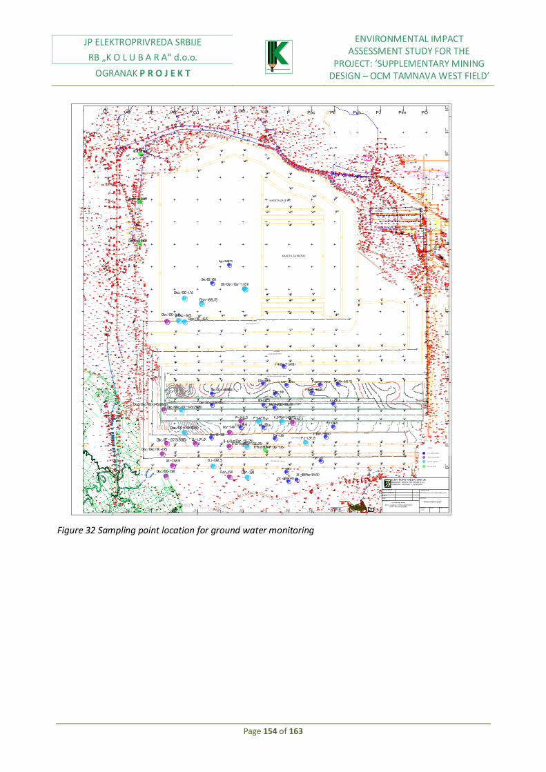
JP ELEKTROPRIVREDA SRBIJE
RB „K O L U B A R A“ d.o.o.
OGRANAK P R O J E K T
ENVIRONMENTAL IMPACT ASSESSMENT STUDY FOR THE
PROJECT: ‘SUPPLEMENTARY MINING DESIGN – OCM TAMNAVA WEST FIELD’
Page 154 of 163
TC 35/6 kv
Put
Vodovod PL F 50
P U TCI GANSKO NASEQ E
dv 2h20 (6) k
30
30
31
31
DV 3
5 K
V JABU^JE
- KALENI }
DV 2
H 3
5 J
ABU^JE -
KALENI }
D V
2
h20
(6
) k
v
B2
B3
P O T O K
Reka
Kl
adni c
a
GROBQ E
1
2
1
1
1
1
TEREN
KOTA VRHA CEVI
O Obc OE Ogh OJ Olm OqrOO Pbc PE Pgh PJ Plm POP
V2
=9
31
m
66
60
62
64
66
64
76
SchRs 630 25/6 (G-1) + BRs 1600 (28+50)x17 (O-2)
52
52 47 42 40 40 40 40 40 45 50
52
27
23
20 25 26
42
23 30
ERs 1000/20 + BRs 1400 (37+50)x16 (BW-4)
SchRs 630 25/6 (G- 4) + BRs 1600 (28+50)x15 (BW-2)
95 95 95 95 95 94 92 92 90 90 85
90 85
90
92 92 92 92 92 91 89 89 87 87 8285 85 85 82 82 80 80 80 80 80 80
62 62
60
72 6560 60 60 60 60 60
47 42 40 40 40 40 40 45 50
27
24
252323
25
21
22 26 27 30 34
34
42
35 4032
5252 4444 44 46 46
40 40 35 32 32
47
44 47 47
46
40
74 70 69 69 69 66 66 66 66 66 66
66
81 81 81 81 81818484848589
81
70
7373
81
109109109
94 94 94
94 94 94
109109109
94
94
109
109109
109
109
109
109
94
94
94
94
94
94 94 94 94 94 94 94 94
94
109 109 109 109 109
E1=1362m
SRs 2000 32/5 + VR(G-2)
O1=2253m
O2=2888m
A2Rs-B 8500x60 (O-1)
A2Rs-B 8500x60 (NOVI)
SchRs 1600 25/3
E4=900m
72
74
68
6870
70
72
60
62
64 44
52
54565866
52
50 5048
48
46
4644
52
54 56
58
54
56
54 52
20
20
20
18
18
18
1816
1614
12
22
22
22
22
24
2424
26
28
16
14
20
18
26
28 30
32
34
36
38
40
42
44
30
7272
72
V1
=1
53
0m
U1=2850m
U2=2800m
U3=40m
94
94
94
94
94
94
Omj1=1000m
KASETA ZA GI PS
KASETA ZA PEPEO
Vm
j=4
54
m
SU
1=
90
0m
S
UP
1=
70
2m
Pregradno mesto br. II
SI TUACI ONA KARTA
Povr { i nskog kopa " Tamnava-Zapadno poq e "
-St awe r adova kr aj 2012 god.-
" Tamnava-Zapad no poq e"
"Kol ubar a-Povr { i nski kopovi "-Bar o{ evac
Dat um : Br oj cr t e` a :
E P S
OBJEKAT:
Razmer a:
1:5000
Obr adi o:
Cr t ao:
Gl avni pr ojekt ant :
Odgovor ni pr ojekt ant :
OGRANAK " PROJEKT" LAZAREVAC
ELEKTROPRI VREDA SRBI JERUDARSKI BASEN "KOLUBARA"d.o.o.
Nazi v cr t e` a:
I NVESTI TOR :
91
80
ARs (BRs) 1600 (28+50)x17 (BW-5)
54
53
53
89
6260
E5=1000m
E3=880m
E2=1500m 94
U4=2759m
58
SU
2=
77
7m
32 Omj2=1802m
kr ovi nski pi jezomet r i
me| usl ojni pi jezomet r i
podi nski pi jezomet r i
LEGENDA
podi nski bunar i
Figure 32 Sampling point location for ground water monitoring

JP ELEKTROPRIVREDA SRBIJE
RB „K O L U B A R A“ d.o.o.
OGRANAK P R O J E K T
ENVIRONMENTAL IMPACT ASSESSMENT STUDY FOR THE
PROJECT: ‘SUPPLEMENTARY MINING DESIGN – OCM TAMNAVA WEST FIELD’
Page 155 of 163
Figure 31 Initial allocation of points for noise monitoring

JP ELEKTROPRIVREDA SRBIJE
RB „K O L U B A R A“ d.o.o.
OGRANAK P R O J E K T
ENVIRONMENTAL IMPACT ASSESSMENT STUDY FOR THE
PROJECT: ‘SUPPLEMENTARY MINING DESIGN – OCM TAMNAVA WEST FIELD’
Page 156 of 163
10.NON-TECHNICAL SUMMARY DATA SPECIFIED in 1-10
Coal, as energy raw material for Republic of Serbia has imprecisely significance, especially considering that 70% of electricity is obtained by this material combustion. There are three large coal deposits in Republic of Serbia: Kolubara, Kostolac and Kosovo mining basin. However, due to well-known development Electric Power Industry of Serbia (EPS) in near future will, most probably, with certainty, could depend only on Kolubara and Kostolac basin. Kolubara mining district is located in Republic of Serbia, approximately 50 km to the south - southwest direction of Belgrade, the country capital city. It covers areas of municipalities Lazarevac, Lajkovac, Ub, and Koceljeva, as well as smaller parts of municipalities of Arandjelovac, Barajevo and Obrenovac, with total area, approximately, about 600km2, of which, areas with coal reserves cover only 167km2.
This area is characterized by lowland and slightly inundated terrains around river Kolubara, Tamnava, Pestan, and Turija. It belongs to Kolubara basin which includes wide area between Valjevo Mountains and Rudnik at south, Sumadija Mountains at east, Sava River at north Cer and Vlasic at west. It has the shape of quadrilateral, widt width 75-80 km, and length approximately 60km.
Kolubara River divides basin in two parts with its midstream, east and west. In east part there are active open cast mines field "B" and "D", mined out field "A" and perspective fields, i.e., future open cast mines: field "C", "E","G", "F", Sopici and Veliki Crljeni. In west part of basin there are "Tamnava- East Field" mined out open cast mine, and "Tamnava West Field" an active open cast mine as well as perspective mine "Radljevo".
Deposit is situated at the area of municipalities of Lajkovac and Ub, in the area of Kalenic Mali Borak, Radljevo, and Skobalj, that is on the pages:7D29 Stepojevac (32, 33, 42, 43, 52, 53, 62, 63, 72, 73, 82, 83)
Deposit is characterized by good transport conditions and communication connections.
Deposit Tamnava West field could be divided in lowland and hill area.
Lowland area covers north and northeast part of field and consists of alluvion of the lower flow of river Kolubara and its tributary Kladnica. Old river beds have characteristic morphological form. Altitude of this terrain is 80-95 m. Deposit is affected by technogenous processes every day, due to dynamic loading from mining equipment.
Hydro geology of "Tamnava West Field deposit" includes rivers, small rivers, and streams with constant and periodic flow. Each flow belongs to the catchment area of river Kolubara, which has its direction east from deposit. River Kolubara belongs to the River Danube catchment area. The only constant surface flow within deposit is River Kladnica with course direction from south west towards north east. River Kladnica has characteristics of calm, quite and low land river. Ravines, like Duboki potok, have water amounts only in rainy period.
Upstream of "Tamnava West field" deposit, at River Kladnica, between Paljuv and Vis, earth dam was constructed and reservoir was created for the goal of open cast mine protection from surface water.
At the wider area of Kolubara basin mild continental climate, with relatively worm summers and mild cold winters.
Average annual air temperature is +11, 6˚C.

JP ELEKTROPRIVREDA SRBIJE
RB „K O L U B A R A“ d.o.o.
OGRANAK P R O J E K T
ENVIRONMENTAL IMPACT ASSESSMENT STUDY FOR THE
PROJECT: ‘SUPPLEMENTARY MINING DESIGN – OCM TAMNAVA WEST FIELD’
Page 157 of 163
Strong winds are not common in subject area.
According annual precipitation amount, this area is moderately humid area with average precipitation amount of 650-1000 mm.
The coal measures occur at the interface between the Lower and Upper Pontian strata. The coal measures consist of alternations of lignite deposits and “interbeds” that generally consist of grey sand, calcareous sands and clay sand clay. The formation is generally heterogeneous in thickness, lithology and characteristics of the interbeds. In the Tamnava West area the coal seam represents a natural prolongation of the coal series that spreads from the eastern part of the Kolubara basin. The strata follow a slightly folded tectonic structure, generally dipping gently in a south westerly direction. The crests of the anticlines are often exposed above ground level and therefore eroded. Open cast mine "Tamnava West field" opening, initiated in 1985, by construction of the cut for opening – dewatering from the north side. This open cast mine previously has purpose for coal supplying of the future TPP Kolubara B (installed capacity 2x350 MW). Since this thermal power plant has not been constructed yet, coal from this open cast mine is used for the needs of TPP Nikola Tesla (installed capacity 2x620 MW).
Seam Category РР
Geological reserves
( t )
Balance reserves
( t )
Off balance reserves
( t )
Complex coal series
"А" 42 538 636 42 538 636 -
"B" 165 051 487 164 997 155 54 332
"C1" 292 626 000 286 291 978 6 334 022
Total "А"+"B"+"C1" 500 216 123 493 882 101 6 388 354
Overburden excavation is performed by two systems:
I ECS system consist of: Bucket wheel excavator SRs 2000 32/5, Conveyor belt B=2000 mm, and spreader A2Rs-B 8500x60. II ECS system consist of: Bucket wheel excavator SchRs 630 25/6, self-propelled belt conveyor BRs 1600 (28+50)x15, conveyor belt B=1600mm and spreader АRs (BRs) 1600 (28+50)x17. Coal mining is performed with two systems: I ECCP system consist of: Bucket wheel excavator SchRs 630 25/6, conveyor belts B=1600mm.
II ECCP system consists of: Bucket chain excavator ЕRs 1000/20 and self-propelled belt conveyor BRs 1400 (37+50)x16, as well as bucket wheel excavator SchRs 630 25/6 and self-propelled belt conveyor BRs 1600 (17,5+32,5)x15, operating next to conveyor belt B=1600mm. Coal loading is performed from bench conveyor I and II ECCP systems, through shifting stations, at collection transporter B=2000mm transporting coal to the crushing plant. Interburden loading from coal is performed through the same shifting stations with coal collection transporter, transporting interburden on the interburden dump. Interburden disposal is performed through spreader АRs (BRs) 1600 (28+50)x17.

JP ELEKTROPRIVREDA SRBIJE
RB „K O L U B A R A“ d.o.o.
OGRANAK P R O J E K T
ENVIRONMENTAL IMPACT ASSESSMENT STUDY FOR THE
PROJECT: ‘SUPPLEMENTARY MINING DESIGN – OCM TAMNAVA WEST FIELD’
Page 158 of 163
Environmental pollution sources are registered: 1. Water pollution During coal mining waste waters are created in two manners: 1. Ground waters are released by overburden excavation, by excavation of coal seam and from floor coal seam where water is under pressure. 2. Surface rain waters falling on the mining field (current area 280 ha) and collecting into water collector, located at the lowest elevation of the mine. Sanitary waste waters are treated in "Putoks" facility, and treated are going into old part of river bed Kladnica, and further by normal flow of the same river. 2. Air pollution Mineral dust is one of significant potential hazard for the air, whose emission value in certain natural conditions could be above permitted level prescribed for settled areas.
Characteristic air pollution sources by suspended particles are: point (excavator, loader), linear (roads on open cast mines, belt conveyors) and surface (active areas on the open cast mine and disposal site).
Primary sources are mining machinery and technological equipment in operation, and secondary sources are all active areas, which under the wind impact emit floating fraction from sediment dust.
Total intensity of air pollution depends on the meteorological conditions, which means that sometimes in dry periods may present potential air pollutant within active area. 3. Soil degradation Mining activities will bring soil degradation at the area of open cast mine Tamnava West field, and also changes within morphological terrains structure.
4. Noise impact
Possibility of appearance of negative noise impact in working environment exists in each exploitation phase on open cast mines. Main noise sources are mining machines: loaders, excavators, bulldozers, conveyor belts, trucks.
Noise level estimation indicates that there will not be significant noise impact from technological process of coal excavation, because noise levels do not exceed permitted values, which are for example, for business-residential area, in IV zone, 50-60 dB. This means that condition for minimum of necessary open cast mine distance, from the nearest residential facilities, is fulfilled.
During planning and designing process of open cast mining of mineral raw deposits there is no dilemma related to the choice of location, or consideration possibility of alternative solutions, because the location of the open cast mine is in exploitation function of the subject mineral raw material deposit. Alternatives exists, but not in domain location itself.
Based on feasibility study of coal supplying strategy in Serbia, it is concluded that open cast mine Tamnava West field is one of the most appropriate and economically the most profitable mine, which could supply Serbia with electricity during next several years.

JP ELEKTROPRIVREDA SRBIJE
RB „K O L U B A R A“ d.o.o.
OGRANAK P R O J E K T
ENVIRONMENTAL IMPACT ASSESSMENT STUDY FOR THE
PROJECT: ‘SUPPLEMENTARY MINING DESIGN – OCM TAMNAVA WEST FIELD’
Page 159 of 163
Proposed mining activities in Tamnava West field, already had impact on local community, considering expropriation is already done in village Kalenic and population is resettled.
With mining activities progress, excavated parts, north from active part of the mine will be reclaimed for the purpose of renewal of entire ecological balance of the subject area. Bigger part of animal species will leave from this area due to mining activities, with exception of bird species and reptiles which could adjust to changed area.
Noise emission from mining activities will have negative impact on animal species in surrounding mine area.
Activities on changing direction of river Kladnica and construction of new reservoir will have negative effect on fish species.
Base on consideration and analyses of designed and projected mining activities, predicted by this project, it is possible to perform lignite mining impacts on soil. The main impact is regarding to the upper structure deterioration during mining activities. Specified negative impact may appear as consequence of the upper seam excavation and its inadequate disposal, as well as the consequence of mixing upper seam with lower and other infertile materials.
The issues of occupation of the areas necessary for open cast mine development as well as for all accompanying parts necessary for coal mining operation, presents one of the important parameters for relations between open cast mine and environment.
At the observed area there is no possibility for soil pollution by oil derivates, because operation process has predicted limited amount for mining, loading, transport and auxiliary machines, completely in accordance with legal regulations.
During mining activities at the subject area, it is very possible that hydrological regime will be disturbed.
Hydrological network of the area of Tamnava West field will be significantly changed by mining activities. Main activities which will have direct impact are changing of direction of river Kladnica and construction of reservoir and pumping station.
Except these impacts, potential negative impacts are possible to happen on surface water quality due to:
Discharge of non treated or not enough treated waste waters from administrative facilities of the mine
Surface waste waters contamination from auxiliary mining activities as the result of oil spilling.
Regarding the air pollution, open cast mine in some time conditions become large dust emitter. This implies to period of strong winds blowing with the speed higher than 7-10 m/s.
Dust sources are:
Dry areas with active benches and overburden dumps

JP ELEKTROPRIVREDA SRBIJE
RB „K O L U B A R A“ d.o.o.
OGRANAK P R O J E K T
ENVIRONMENTAL IMPACT ASSESSMENT STUDY FOR THE
PROJECT: ‘SUPPLEMENTARY MINING DESIGN – OCM TAMNAVA WEST FIELD’
Page 160 of 163
Roads
Mining equipment and machines
Open cast mine Tamnava West field does not, and will not significantly affect climate change within mining area and its surrounding.
Mining activities may have negative impact on archeological remains located on the road. Aimed at avoiding this possibility, mine management is in touch with archeologists who are always ready to visit mine examine objects of interests.
In order to increase technical solution quality on the environment, additional protection measures are predicted:
In active part of the mine, where mining activities are in progress, procedure of water spraying is possible to be applied for the purpose of dust emission prevention from active operating areas and other specific places like shifting from one conveyor to the other, whether it is about belt system or it is about belt -belt system on the excavator. In case of shifting stations, it is also possible to apply dust capture procedure on them.
For dust emission prevention from active operating areas, as mentioned before, it is possible to apply technical solution of water spraying and wetting procedure with tankers followed by spraying equipment.
Regular application of all this procedures with time planning, with use of available technical possibilities, provides effects for dust emission reduction and air protection in the environment. Air conditioning (dust capture) in mining machines cabins, transport machines and auxiliary works, is protection measure need to be applied.
Exogenous fires are caused by outside factors activity: open flame, sparks, and electric arc…Protection from it includes all usual prevention measures.
Noise sources are not included within category of expressed potential harmful impacts on living environment, due to relatively low noise level during normal operation. Maximal permitted noise level in those conditions is 90 dB, which is outside mine borders, i.e., it will not exceed prescribed values of 55 dB, 45 dB. In concrete case, distance condition is going to be fulfilled.
Soil protection
Regarding soil complex, affected by mining activities, reclamation is predicted (technical, agro technical and biological).
Water protection
Waste waters from technical and workshop complex will be directed by special sewage systems and will be treated in separate devices, and treated they will be discharged within recipients.

JP ELEKTROPRIVREDA SRBIJE
RB „K O L U B A R A“ d.o.o.
OGRANAK P R O J E K T
ENVIRONMENTAL IMPACT ASSESSMENT STUDY FOR THE
PROJECT: ‘SUPPLEMENTARY MINING DESIGN – OCM TAMNAVA WEST FIELD’
Page 161 of 163
Protection against ground and surface waters
Open cast mine is operating figure changing it relief by mining activities progress. Enter parameters for solving of mine protection issues against waters are:
Climate data from meteorological station Kalenic
Initial state of mining activities at open cast mine Tamnava West field for 2003 with position of dewatering facilities
Existing dewatering equipment on the mine
Data on water level
Geological and hydrological documents developed by this project
Designed mining activities for upcoming period
Mine protection concept is following:
Mine protection against ground waters from roof coal series is performed by development of sealing wall construction by method "masses replacement" from the east side of the mine.
Mine protection against surface and ground waters collected in operating area is performed by development of drainage, slope channels and direction of water flow to the water collectors. From water collectors it is transported by pump aggregates through pipeline to the recipients – rivers Kolubara and Skobalj
Environment impact monitoring program includes:
Ground and surface waters monitoring
Air quality monitoring
Noise measurement
Monitoring of land quality, land use, and application of technical and biological reclamation
11. DATA ON TECHNICAL DEFECTS OR NONEXISTANCE OF CERTAIN EXPERT SKILLS
There are no data on technical nonexistence of certain expert skills.
An expert cooperation level regarding subject study, by the Employers side, was at a high level.
This is not only guarantee, and for that reason, an adequate monitoring is predicted by this study, and it has to be implemented in accordance with the legal regulation.
12. STUDY DEVELOPERS DATA
Stojanovic Slavica, B.Eng.
She graduated from Mining-Geology faculty, University of Belgrade (1991), department for Mining, section for preparation of mineral raw material. She was employed in1993 in MB Kolubara "Tamnava West field", where she worked until 1.4.2000, when transferred in "Kolubara Project", Lazarevac, as independent designer. She is employed as leading designer in PE MB Kolubara, Kolubara Project.
Marina Vuckovic, B.Eng

JP ELEKTROPRIVREDA SRBIJE
RB „K O L U B A R A“ d.o.o.
OGRANAK P R O J E K T
ENVIRONMENTAL IMPACT ASSESSMENT STUDY FOR THE
PROJECT: ‘SUPPLEMENTARY MINING DESIGN – OCM TAMNAVA WEST FIELD’
Page 162 of 163
She graduated from Mining-Geology faculty, University of Belgrade, department for Mining, section for preparation of mineral raw material. She was employed in 1995 in RTB Bor, copper ore flotation Veliki Krivelj.
She worked for a year in DP Rudnik. In PE MB Kolubara, Kolubara Project, Lazarevac is employed from 2004 as independent designer.
Dejan Sabov, B.Eng. He graduated from Mining Geology faculty; University of Belgrade, department for Mining, section-open cast mining. Mr. Sabov was employed in 1987, in DP Kolubara-Open cast mines – Field D, where he was responsible for several activities – operation, technical preparation, and shift leader, chief of overburden system, chief of coal system. From 2005 he is employed as leading engineer in DP Kolubara Project. Drgan Buhac, B. Eng. He graduated from Mining Geology faculty; University of Belgrade, department of Geology, section hydro geology. He was employed in G.P Partizanski put in Belgrade, as laboratory engineer. From 2003 he is employed in PE MB Kolubara, DP Kolubara Project, as independent designer.
13. LITERATURE
1. Faculty of Mining and geology – Actualized investment program of open cast mine Tamnava West field development (2007);
2. Feasibility study of selective mining and overburden disposal– according to the contract 3476 dated 11.04.2003 Academy of engineering of sciences Serbia and Monte Negro (2006);
3. Presentation "Project: Procurement of II ECS System for Tamnava West field –history and project significance " Lazarevac (February,2008);
4. Spatial plan of Kolubara lignite basin mining area – Institute for architecture and zone planning of Republic of Serbia, April, 2007;
5. Strategic impact assessment of Kolubara lignite basin spatial plan on the environment – Institute for architecture and zone planning of Republic of Serbia, April, 2007;
6. Supplementary mining project of the open cast mine Tamnava west field (Kolubara Projekt, Lazarevac, 2008)
7. Study on impact assessment of open cast mine Tamnava west field current state on the environment of the project: Supplementary mining project of the open cast mine Tamnava west field "(2007, Mining Institute, Belgrade-Zemun).
8. General mining design of the project open cast mine Tamnava west field (Kolubara Projekt, Lazarevac, 1992/93.)
9. Investment program of open cast mine Tamnava West field development (Kolubara Projekt, Lazarevac, 1983):
10. General mining design of the project open cast mine Tamnava west field, Book 2/2 Conceptual design of reclamation (Forestry Institute, Belgrade, 1994);
11. Technical facilities project of open cast mines Tamnava west field opening, Book 1, notebook 1, Geology, hydro geology and geomechanic (Kolubara Projekt, Lazarevac, 1984);
12. Detail study of the most rational solution of relocation and water courses regulation in west part of Kolubara basin between Kolubara and Ub (RO Hidroprojekat, Belgrade, 1984);
JP ELEKTROPRIVREDA SRBIJE
RB „K O L U B A R A“ d.o.o.
OGRANAK P R O J E K T
ENVIRONMENTAL IMPACT ASSESSMENT STUDY FOR THE
PROJECT: ‘SUPPLEMENTARY MINING DESIGN – OCM TAMNAVA WEST FIELD’
Page 163 of 163
13. Feasibility study of dislocation of capital infrastructure facilities and river water courses in function of coal open cast mining protection in Kolubara basin, (Water management Institute Jaroslav Cerni, CIP traffic Institute, TEKON, Belgrade, 2005);
14. Study on coal reserves in deposit Tamnava west field –Kolubara basin (State on 31.12.2004.);
15. Water management Institute Jaroslav Cerni, Belrade- Tecnical project of OCM Tamnava west field dewatering (2005).
16. EPS II Power II – Tamnava West Lignite Mine – Consulting Services for Lender's Environmental Engineer-Mining Institute, Belrade /Tekon – Tehnokonsalting Belrade, 2008
17. Dr Milutin Ljesevic -Environment 1,Belgarde, 2005 18. Dr Milutin Ljesevic –Urban ecology 2, Belgrade, 2005 19. Dr Milutin Ljesevic -Environmet 3, Belgrade, 2005 20. N.Lilic, A.Cvjetic –Noise and vibrations in mining,2007 21. EPS II Ponjer-Tamnava West Lignite Mine –Mining Institute, Zemun; Tekon-
tehnokonsalting 2008 22. Spatial Plan of Republic of Serbia (Official Gazette of RS No.13/96). 23. Institute for architecture and zone planning of Republic of Serbia, "Spatial plan of kolubara
lignite basin mining area ", Belgrade, 2000. 24. Study "Area reservation in Kolubara coal basin by 2020 in function of open cast mining
development ",2003, Mining Institute, Belgrade 25. River Kolubara relocation (according to the General design) 26. Spatial plan of Kolubara lignite basin mining area. (Knezevic V.1964,1975,1981)
27. Road institutes a.d. Belgrade, "Environment study – Previous impact analysis”, General
project highway road M-22, Belgrade-Ljig, Belgrade, 2001.
28. Water management Institute Jaroslav Cerni, Belgrade, Detail impact analysis of CHP
Kolubara B under construction, on the environment with impact analysis elements and
protection measures of ahs disposal site, Belgrade, 1998.
29. Institute Kirilo Savic, "Mid-term program of protection and improvement of municipality of
Lazarevac area ", Belgrade, 1998.
30. Forestry institute - Belgrade, Ministry of environmental protection of Republic of Serbia
“Reclamation of areas of open cast mines of Kolubara lignite basin ", Belgrade, 1997.
31. Republic hydro meteorological institute, “Annual values of meteorological elements
according to data of SMS Tamnava in period 1984 - 2003 ", Belgrade, 2003.
32. Institute Vinca, "Tamnava East" and "Tamnava West" Coal and Ash Radioactivity and Radio
ecological Influence to the TPP "Kolubara B" Environment, Beograd, 1990.
33. Mining Institute Belgrade, Study on periodical investigations of chemical harmful impacts
and microclimate conditions of working environment in units "«Kolubara – Open cast
mines", summer period, 2003.
14. Annex