impact of shutting down en route primary radars within ... · nl {jj 7. i dot/faa/nr-93-1...
TRANSCRIPT

Nl {jJ 7. I DOT/FAA/NR-93-1
DOT-VNTSC-FAA-93-1
Office of Program Director for Surveillance Washington, DC 20591
FAA WJH Technical Center
l\11111111111111111111111111111\lllllllllll\\\\lll 00093516
Impact of Shutting Down En Route Primary Radars within CONUS Interior
Janis Vilcans
Research and Special Programs Administration
John A. Volpe National Transportation Systems Center
Cambridge, MA 02142-1093
Final Report June 1993
This document is available to the public through the National Technical Information Service Springfield, Virginia 22161
U.S. Department of Transportation Federal Aviation Administration
\ ~\':\ :':

NOTICE
This document is disseminated under the sponsorship of the Department of Transportation in the interest
of information exchange. The United States Government assumes no liability for its contents or use thereof.
NOTICE
The United States Government does not endorse products or manufacturers. Trade or manufacturers'
names appear herein solely because they are considered essential to the object of this report.

REPORT DOCUMENTATION PAGE Form ApJroved OMB No. 704-0188
Public reporting burden for this collection of information is estimated to average 1 hour per re~nse, including the time for reviewtng instructions searchin? existi~ data sources, gathering and maintaining the ata needed, and completing and reviewiQ9 the collection o informs ion. Send comments regarding this burden estimate or anv. other as~t of t~is collection of information, including suggestions for reductng thts burden, to Washin~ton Hea9quarters ~~~~~%~()l' ~~t~~a~~ .. fg~fl~!o~ti on Operat!~s8= .. ~ePQrts, 1215 R~~~~~~~P~~Y!~t H]ft~~2~,11 ~i teu!:;~t:. .. ~~~ iriB~o2(lsX~ 1. AGENCY USE ONLY (leave blank) 2. REPORT DATE 3. REPORT TYPE AND DATES COVERED
June 1993 Final Report · June 1992 • Feb. 1993
4. TITLE AND SUBTITLE 5. FUNDING NUMBERS Impact of Shutting Down En Route Primary Radars within CONUS Interior A3156/FA3MS
6. AUTHOR($) Janis Vilcans
7. PERFORMING ORGANIZATION NAME(S) AND ADDRESS(ES) 8. PERFORMING ORGANIZATION u.s. Department of Transportation REPORT NUMBER Research and Special Programs Administration
DOT-VNTSC-FAA-93-1 John A. Volpe National Transportation Systems Center Cambridge, MA 02142-1093
9. SPONSORING/MONITORING AGENCY NAME(S) AND ADDRESS(ES) 10. SPONSORING/MONITORING u.s. Department of Transportation AGENCY REPORT NUMBER Federal Aviation Administration
DOT/FAA/NR-93-1 Office of En Route Radar Surveillance 800 Independence Avenue, SY Washington, DC 20591
11. SUPPLEMENTARY NOTES
12a. DISTRIBUTION/AVAILABILITY STATEMENT 12b. DISTRIBUTION CODE
This document is available to the public through the National Technical Information Service, Springfield, VA 22161
13. ABSTRACT (Maximum 200 words)
The impact on the Air Traffic Control (ATC) operations resulting from the shutdown of all en route primary radars (except for ARSR-4s) within the CONUS interior will result in loss of real·time weather data and aircraft skin tracking, over 33 percent primary surveillance loss of coverage in the CONUS, and an increase in the accident rate of one accident in 11 years as predicted on recent statistics.
The report concludes that real-time weather data, while of limited quality, must be retained until it can be replaced by data from the NEXRAD weather radar or other weather data source. Ability to track non-transponder equipped aircraft is significant but less critical and can be minimized by other system improvements. These include: better beacon radar (ModeS) in combination with Traffic Alert and Collision Avoidance System (TCAS) and Automatic Dependent Surveillance CADS); increased transponder equipage; reduced altitude for non-transponder equipped aircraft to 10 thousand feet; increased DF network to 370 sites; and better siting of beacon-only antennas.
Based on current availability, projections (derived from Capital Investment Plan (CIP) schedules), the most feasible en route primary radar shutdown date is the year 2008. If weather data from external sources can be made available on controllers• displays before that time (for example, by 1998 when ISSS is installed), that data can be advanced.
14. SUBJECT TERMS
Primary Radar, Mode S, CONUS Coverage, NEXRAD, Automatic Dependent Surveillance {ADS), ATC Radar Beacon System {ATCRBS)
17. SECURITY CLASSIFICATION 18. SECURITY CLASSIFICATION 19. SECURITY CLASSIFICATION OF REPORT OF THIS PAGE OF ABSTRACT Unclassified Unclassified Unclassified
NSN 7540-01-280-5500
15. NUMBER OF PAGES 46
16. PRICE CODE
20. LIMITATION OF ABSTRACT
Unclassified
-Standard Form 298 (Rev. 2 89) Prescribed by ANSI Std. 239-18 298-102


PREFACE
The work described in this report was performed under Project Plan Agreement FA-3M5 for the Federal Aviation Administration (FAA), Program Office for En Route Radar. The Sponsor of the project, Richard J. Lay, ANR-400, directed the work study effort.
The work was performed by the Department of Transportation/Research and Special Programs Administration/Volpe National Transportation Systems Center, Surveillance and Sensor Division. This report presents a comprehensive study of the impact on en route primary radar shutdown on Air Traffic Control (ATC) operations.
The author wishes to thank Richard J. Lay, the Program Manager for En Route Radar, for his support and guidance during this study and Edward A. Spitzer, Chief, Surveillance and Sensors Division, and Paul E. Manning, DTS-53, for this review and valuable suggestions. Especially grateful acknowledgements go to Dr. E. Michael Geyer and Alan G. Cameron, The Analytic Sciences Corporation (TASC), for their technical inputs to this study. Also, appreciation goes to Douglas Hodgkins, ASE-300 and William G. Collins, FAA ANR-102 for their valuable technical inputs; to Diane Essig-Hooper, APM-130, for verifying the FY -93 CIP cost figures; to Mark Clark and Louis Fisher, Martin Marietta, for their detailed cost estimates; and to Henry I. Wychorski, UNISYS, for his contribution to the Remote Maintenance Monitoring System (RMMS) section. The draft report was reviewed by Teddy Boatright, ANR-110, James D. Duffer, ANR-110, Billy Holland, ANR-110, Michael J. Polchert, ANR-110, Theodore H. Weyrauch, ANR-110, and Arthur L. Levy, ANR-150. Their valuable contributions and comments to improve this report are appreciated. Special thanks go to Anita Graffeo, EG&G Dynatrend, for editing and preparing this document.
iii

METRIC/ENGLISH CONVERSION FACTORS
ENGLISH TO METRIC
LENGTH (APPROXIMATE)
inch (in) = 2.5 centimeters (em)
foot (ft) = 30 centimeters (em)
yard (yd) = 0.9 meter (m)
1 mile (mi) = 1.6 kilometers Ckm)
AREA (APPROXIMATE)
1 square inch (sq in, in2 = 6.5 square centimeters (cm2> 1 square foot (sq ft, ft 2 = 0.09 square meter (~)
1 square yard (sq yd, y~) = 0.8 square meter cm2> square mile (sq mi, mi 2> = 2.6 square kilometers Ckm2> acre = 0.4 hectares (he) = 4,000 square meters cm2>
MASS - WEIGHT (APPROXIMATE)
1 ounce (oz) = 28 grams (gr)
1 pound Clb) = .45 kilogram (kg)
short ton= 2,000 pounds Clb) = 0.9 tonne (t)
VOLUME (APPROXIMATE)
teaspoon (tsp) = 5 milliliters (ml)
tablespoon (tbsp) = 15 milliliters (ml)
1 fluid ounce Cfl oz) = 30 milliliters (ml)
1 cup (c)= 0.24 liter (1)
1 pint (pt) = 0.47 liter (1)
1 quart (qt) = 0.96 liter (1)
gallon (gal) = 3.8 liters (1)
1 cubic foot (cu ft, ft3) = 0.03 cubic meter cm3)
cubic yard (cu yd, y~) = 0.76 cubic meter cm3>
TEMPERATURE (EXACT)
[(x-32)(5/9)] °F = y 0c
METRIC TO ENGLISH
LENGTH (APPROXIMATE)
millimeter (mm) = 0.04 inch (in)
centimeter (em) = 0.4 inch (in)
1 meter (m) = 3.3 feet (ft)
1 meter (m) = 1.1 yards (yd)
kilometer (km) = 0.6 mile Cmi)
AREA (APPROXIMATE)
square centimeter (cm2) = 0.16 square inch (sq in, in2>
1 square meter cm2> = 1.2 square yeards (sq yd, yd2>
1 square kilometer (km2> = 0.4 square mile (sq mi, mi 2> 1 hectare (he) = 10,000 square meters Cm2> = 2.5 acres
MASS - WEIGHT (APPROXIMATE)
1 gram (gr) = 0.036 ounce (oz)
kilogram (kg) = 2.2 pounds (lb)
tonne (t) = 1,000 kilograms (kg)= 1.1 short tons
VOLUME (APPROXIMATE)
milliliters Cml> = 0.03 fluid ounce (fl oz)
liter (1) = 2.1 pints (pt)
liter (1) = 1.06 quarts (qt)
liter (1) = 0.26 gallon (gal)
cubic meter cm3> = 36 cubic feet (cu ft, ft3)
cubic meter cm3) = 1.3 cubic yards (cu yd, yd3)
TEMPERATURE (EXACT)
[(9/5) Y + 32] °C = X °F
QUICK INCH-CENTIMETER LENGTH CONVERSION
INCHES 0 2 3 4 5 6 7 8 9
CENTIMETERS 0 2 3 4 5 6 7 8 9 10 11 12 13 14 15 16 17
QUICK FAHRENHEIT-CELSIUS TEMPERATURE CONVERSION
OF -40° -22° -40 14° 32° 50° 680 860 104° 122° 140° 158° 176° 194°
oc I -40° -3b0 I
-20° I
-10° bo 1bo I 20° 3b0· Jo I
50° I
60° I
70° sb0 I 90°
For more exact and or other conversion factors, see NBS Miscellaneous Publication 286, Units of Weights and Measures. Price $2.50. SO Catalog No. C13 10286.
10
212° I
100°
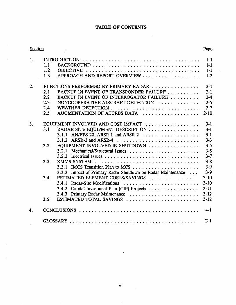
TABLE OF CONTENTS
Section
1. INTRODUCTION . . . . . . . . . . . . . . . . . . . . . . . . . . . . . . . . . . . . . 1-1 1.1 BACKGROUND . . . . . . . . . . . . . . . . . . . . . . . . . . . . . . . . . . 1-1 1.2 OBJECTIVE ..... ~ . . . . . . . . . . . . . . . . . . . . . . . . . . . . . . 1-1 1.3 APPROACH AND REPORT OVERVIEW. . . . . . . . . . . . . . . . . . 1-2
2. FUNCTIONS PERFORMED BY PRIMARY RADAR . . . . . . . . . . . . . . . 2-1 2.1 BACKUP IN EVENT OF TRANSPONDER FAILURE. . . . . . . . . . 2-1 2.2 BACKUP IN EVENT OF INTERROGATOR FAILURE . . . . . . . . . 2-4 2.3 NONCOOPERATIVE AIRCRAFT DETECTION . . . . . . . . . . . . . 2-5 2.4 WEATHER DETECTION . . . . . . . . . . . . . . . . . . . . . . . . . . . . 2-7 2.5 AUGMENTATION OF ATCRBS DATA . . . . . . . . . . . . . . . . . . 2-10
3. EQUIPMENT INVOLVED AND COST IMPACT . . . . . . . . . . . . . . . . . 3-1 3.1 RADAR SITE EQUIPMENT DESCRIPTION . . . . . . . . . . . . . . . . 3-1
3.1.1 AN/FPS-20, ARSR-1 and ARSR-2 . . . . . . . . . . . . . . . . . . 3-1 3.1.2 ARSR-3 and ARSR-4 . . . . . . . . . . . . . . . . . . . . . . . . . . 3-3
3.2 EQUIPMENT INVOLVED IN SHUTDOWN . . . . . . . . . . . . . . . . 3-5 3.2.1 Mechanical/Structural Issues . . . . . . . . . . . . . . . . . . . . . . 3-5 3.2.2 Electrical Issues . . . . . . . . . . . . . . . . . . . . . . . . . . . . . . 3-7
3.3 RMMS SYSTEM . . . . . . . . . . . . . . . . . . . . . . . . . . . . . . . . . 3-8 3.3.1 IMCS Transition Plan to MCS . . . . . . . . . . . . . . . . . . . . . 3-9 3.3.2 Impact of Primary Radar Shutdown on Radar Maintenance . . . 3-9
3.4 ESTIMATED ELEMENT COSTS/SAVINGS . . . . . . . . . . . . . . . . 3-10 3.4 .1 Radar-Site Modifications . . . . . . . . . . . . . . . . . . . . . . . . 3-10 3 .4. 2 Capital Investment Plan ( CIP) Projects . . . . . . . . . . . . . . . . 3-11 3.4.3 Primary Radar Maintenance . . . . . . . . . . . . . . . . . . . . . . 3-12
3.5 ESTIMATED TOTAL SAVINGS . . . . . . . . . . . . . . . . . . . . . . . 3-12
4. CONCLUSIONS . . . . . . . . . . . . . . . . . . . . . . . . . . . . . . . . . . . . . . 4-1
GLOSSARY . . . . . . . . . . . . . . . . . . . . . . . . . . . . . . . . . . . . . . . . G-1
v

LIST OF FIGURES
Figure
1-1 CONUS ARSR Locations . . . . . . . . . . . . . . . . . . . . . . . . . . . . . . . . . 1-3 2-1 CONUS Radar Coverage . . . . . . . . . . . . . . . . . . . . . . . . . . . . . . . . . 2-3 2-2 FAA Primary Radar Coverage . . . . . . . . . . . . . . . . . . . . . . . . . . . . . . 2-6 2-3 ARSR-Derived Weather Data on Controller's PVD . . . . . . . . . . . . . . . . . 2-8 3-1 Block Diagram of FPS-20, ARSR-1, or ARSR-2 Site . . . . . . . . . . . . . . . . 3-2 3-2 ARSR-3 Standard Configuration . . . . . . . . . . . . . . . . . . . . . . . . . . . . . 3-4 3-3 Data Flow at Beacon-Only Site (Non-Mode S) . . . . . . . . . . . . . . . . . . . . 3-8
LIST OF TABLES
3-1 Planned En Route Primary Radars in the Year 2000 . . . . . . . . . . . . . . . . 3-5 3-2 CIP En Route Radar Program Costs . . . . . . . . . . . . . . . . . . . . . . . . . 3-11 4-1 Summary of En Route Primary Radar Functions . . . . . . . . . . . . . . . . . . . 4-1
vi

EXECUTIVE SUMMARY
E.l INTRODUCTION
The Federal Aviation Administration (FAA) is currently considering shutting down
(removing) its en route primary radars located in the interior of the Continental United States
(CONUS). The contemplated shutdown includes all AN/FPS-20s, and all Air Route Surveillance
Radars (ARSR-ls, ARSR-2s and ARSR-3s) now planned for use in the year 2000 (83 total).
It does not include the 39 new ARSR-4s which will be located on the perimeter of the CONUS
and which will also provide air defense and drug interdiction data as part of the FAA/DOD Joint
Surveillance System (ISS). Locations where primary radar is removed would become beacon
only sites, and would be upgraded to Mode S according to current schedules.
This report assesses the impact of the contemplated shutdown. Specifically, it:
• Describes the functional Air Traffic Control (ATC) capabilities performed by primary radars, assesses their relative values, and identifies candidate replacement systems/procedures/processes (Sections 2 and E.2).
• Identifies the equipment involved in the contemplated shutdown and the associated cost impact (Sections 3 and E.3).
• Expresses tentative conclusions (Sections 4 and E.4).
E.2 PRIMARY RADAR FUNCTIONS
As a part of the National Airspace System (NAS) ATC system, primary radar performs
five specific functions. In decreasing order of importance, these functions are:
• Detection and display of real-time weather information on the controller's Plan View Display (PVD).
• Detection of nontransponder-equipped aircraft.
• Backup to the Air Traffic Control Radio Beacon System (ATCRBS) secondary radar in the event of aircraft transponder failure.
vii

• Backup in the event of ATCRBS ground equipment failure.
• Enhancement of secondary radar surveillance data.
These functions are addressed individually below.
E.2.1 Weather Detection
·Primary radar inl'icates the presence of precipitation within the coverage region, and
currently is the only source of real-time weather data available at the controller's PVD.
Weather data from other sources, including National Weather Service (NWS) radars, are
available within centers, but the information is somewhat delayed and the displays are not readily
accessible to all controllers. The quality of primary-radar-derived weather data for the ARSR-1
and FPS-20 is mediocre: two levels o~ precipitation intensity are depicted, there is no altitude
discrimination, and "false alarms" (overprediction of precipitation) are common. However, the
ARSR-4 and ARSR-3 radars have a separate weather channel and provide information similar
to NEXRAD. One added advantage is that the data is not mosaic and shows location of actual
cells. Despite these shortcomings in the ARSR-1 and FPS-20 radars, it is not prudent to remove
the current capability without providing a replacement. Current FAA plans are to provide
weather data to controllers using NEXRAD as the sensor, the Real-time Weather Processor
(RWP) as the distribution system, and the Advanced Automation System (AAS) Area Control
Computer Complex (ACCC) as the display device. Expected date for completion is the 1998-
2008 time frame. It is likely that a project limited to providing real-time weather to controllers,
possibly using NWS radars, phone lines, and the AAS Initial Sector Suite System (ISSS ) -
could achieve this capability several years earlier.
E.2.2 Nontransponder Aircraft Surveillance
Primary radar is the only source of surveillance data for aircraft not equipped with a
transponder. It is estimated1 that deactivation of the en route primary radars not part of the JSS
would remove surveillance coverage of nontransp~mder equipped aircraft below 10,000 feet over
1Yesley, J .M., and Kitterman, R. W ., Effect of Primary Surveillance Radar on Mid-Air Collision Risk in the En Route Environment, November 1991.
viii

33 percent of the CONUS. The remaining 67 percent of the CONUS would either continue to
be covered by terminal or JSS radars, or does not now have coverage (the contemplated
deactivation would also remove coverage up to 20,000 feet. While nontransponder equipped
aircraft are not authorized to be at these altitudes, occasional blunders do occur). Without
primary radar, controllers would no longer be able to provide advisories to Instrument Flight
Rules (IFR) aircraft concerning the presence of Visual Flight Rules (VFR) traffic in these
regions. The referenced study considered 23 mid-air collisions over a 7-year span, and found
that: the great majority (17) occurred below 6000 feet; and of the remaining 6 collisions, 4 were
VFR/VFR. It predicts that shutting down en route radars will cause a negligible increase in the
rate of IFR/VFR mid-air collisions (one additional accident in the next 30 years). The best
alternative to primary radar for this function is increased transponder equipage. Currently,
approximately 70 percent of general aviation is transponder equipped. Equipage is expected to
rise to approximately 80 percent over the next decade, as a result of both airspace usage
restrictions and the declining cost of avionics units.
E.2.3 Backup in Event of Transponder Failure
Primary radar is a backup source of surveillance data in the event of an IFR aircraft
transponder failure. For the primary radar to be effective, the aircraft must be sufficiently large
and separated from other traffic. Transponder failures are typically observed once every few
days at a center, involving either small general aviation aircraft (in which case primary radar
is marginally effective) or larger military aircraft with older equipment (in which case primary
radar is effective).
A recent study2 addressed the special case of lost aircraft. Of 266 accidents considered,
only 3 were found to have some dependence on primary radar (virtually every accident involved
an inexperienced pilot who did not request help until fuel became short). It concluded that
removal of primary radar is not expected to have a significant impact on the accident rate -- one
additional accident in the next 18 years is predicted. Alternatives to primary radar for this
2Yesley, J .M., and Kitterman, R. W., Impact of Primary Surveillance Radar on Lost Aircraft Accident Rate in the En Route Environment, November 1991.
lX

application are: (1) aircraft reverts to VFR if possible; (2) aircraft voice-reporting of position;
and (3) direction finding based on aircraft voice reports.
E.2.4 Backup in Event of Interrogator Failure
Primary radar can also serve as a backup source of surveillance data in the event of a
secondary radar ground equipment failure. Situations when this backup is used, in which beacon
radar fails while the search radar remains operational, are rare. Moreover, much of the CONUS
airspace has redundant ATCRBS coverage. Alternatives to primary radar for this application
are additional beacon-only installations, and a future Automatic Dependent Surveillance (ADS)
system (possibly based on use of a ModeS data link).
E.2.5 Enhancement of Secondary Radar Data
When primary and secondary radar indicate a target at the same location, the "radar
reinforcement" bit is set in the secondary target message transmitted from the radar site to the
center. When the controller suspects a "false target" is indicated by the beacon, he/she can
employ the reinforcement bit as a crosscheck. There are several alternative ways of improving
the quality of data derived from the beacon radar through additional signal processing. Some
of these techniques (e.g., mapping of the site-specific multipath geometry) have been
implemented for terminal radars and in Mode S, but none has been used for the en route
ATCRBS system.
E.3 EQUIPMENT AND COST IMPACT
E.3.1 Equipment Involved
The following major mechanical/structural changes are expected to be required in order
to convert an existing dual-radar installation to a beacon-only site:
• Removal of primary radar electronics from the equipment room .
• Removal of the radome .
X
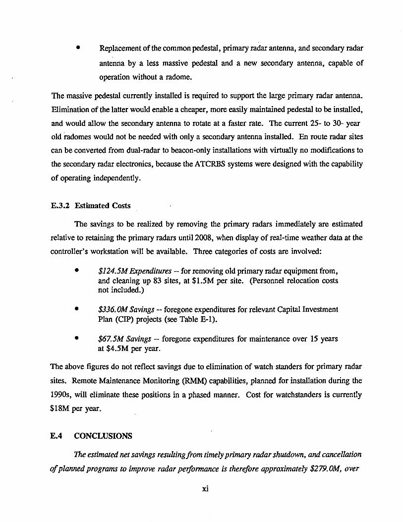
• Replacement of the common pedestal, primary radar antenna, and secondary radar
antenna by a less massive pedestal and a new secondary antenna, capable of
operation without a radome.
The massive pedestal currently installed is required to support the large primary radar antenna.
Elimination of the latter would enable a cheaper, more easily maintained pedestal to be installed,
and would allow the secondary antenna to rotate at a faster rate. The current 25- to 30- year
old radomes would not be needed with only a secondary antenna installed. En route radar sites
can be converted from dual-radar to beacon-only installations with virtually no modifications to
the secondary radar electronics, because the ATCRBS systems were designed with the capability
of operating independently.
E.3.2 Estimated Costs
The savings to be realized by removing the primary radars immediately are estimated
relative to retaining the primary radars until 2008, when display of real-time weather data at the
controller's workstation will be available. Three categories of costs are involved:
• $124.5M Expenditures-- for removing old primary radar equipment from, and cleaning up 83 sites, at $1.5M per site. (Personnel relocation costs not included.)
• $336. OM Savings -- foregone expenditures for relevant Capital Investment Plan (CIP) projects (see Table E-1).
• $67.5M Savings-- foregone expenditures for maintenance over 15 years at $4.5M per year.
The above figures do not reflect savings due to elimination of watch standers for primary radar
sites. Remote Maintenance Monitoring (RMM) capabilities, planned for installation during the
1990s, will eliminate these positions in a phased manner. Cost for watchstanders is currently
$18M per year.
E.4 CONCLUSIONS
The estimated net savings resulting from timely primary radar shutdown, and cancellation
of planned programs to improve radar performance is therefore approximately $279.0M, over
xi

PROJECT
24-15
44-39
44-40
44-42
44-43
Table E-1. CIP En Route Radar Program Costs
(FY -93 Cost Estimates)
NAME I DESCRIPTION AMOUNT
Long-Range Radar (LRR) Program $34.6M
10 ARSR-3 "leapfrog" relocations
LARs relocated as required
(39 ARSR-4s being procured not included in "amount")
Relocate Air Route Surveillance Radars $56.7M
Approximately 2 sites/year to be relocated
Long-Range Radar Improvements $186.2
Improvements to older LARs: controls for ARSR-1 and
-2s, cable trays cleaned-up, grounding upgraded
Long-Range Radar Radome Replacement $31.0M
Replace radomes at all existing LRR sites: most are 25
to 30 years old (signal distortion and maintenance are
issues), and will not accommodate taller ModeS
antenna
Radar Pedestal Vibration Analysis $0.5M
Install vibration sensors and analysis equipment, in
order to better manage maintenance activities
Solid State Transmitter Program $27.0M
the 15-year period 1993-2008. This total includes only savings derived from elimination of
primary radar coverage, and does not account for the costs of planned programs to augment
secondary radar coverage and performance (for example, CIPs 24-12, 44-45, and 44-46) or
otherwise improve surveillance (ADS). To the extent that additional improvements to the
remaining surveillance system would be appropriate to compensate for loss of primary radar,
a case can be made for including a portion of their costs. Since such improvements have not
yet been defined, there is no means of estimating these costs at present, and therefore they were
not included.
xii
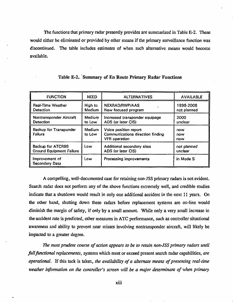
The functions that primary radar presently provides are summarized in Table E-2. These
would either be eliminated or provided by other means if the primary surveillance function was
discontinued. The table includes estimates of when such alternative means would become
available.
Table E-2. ·Summary of En Route Primary Radar Functions
FUNCTION NEED ALTERNATIVES AVAILARII=
Real-Time Weather High to NEXRAD/RWP/AAS .... 1998-2008 Detection Medium New focused program not planned
Nontransponder Aircraft Medium Increased transponder equipage 2000 Detection to low ADS (or later CIS) unclear
Backup for Transponder Medium Voice position report now Failure to low Communications direction finding now
VFR operation now
Backup for A TCRBS low Additional secondary sites not planned Ground Equipment Failure ADS (or later CIS) unclear
Improvement of Low Processing improvements in ModeS Secondary Data
A compelling, well-documented case for retaining non-JSS primary radars is not evident.
Search radar does not perform any of the above functions extremely well, and credible studies
indicate that a shutdown would result in only one additional accident in the next 11 years. On
the other hand, shutting down these radars before replacement systems are on-line would
diminish the margin of safety, if only by a small amount. While only a very small increase in
the accident rate is predicted, other measures in ATC performance, such as controller situational
awareness and ability to prevent near misses involving nontransponder aircraft, will likely be
impacted to a greater degree.
The most prudent course of action appears to be to retain non-JSS primary radars until
full functional replacements, systems which meet or exceed present search radar capabilities, are
operational. If this tack is taken, the availability of a alternate means of presenting real-time
weather i'lformation on the controller's screen will be a major determinant of when primary
xiii

-----·-----------------
radar can be decommissioned. Several current and planned programs (ISSS, ACCC, RWP,
NEXRAD) impact that availability. Each must undergo significant development and integration,
and some are currently being examined by the FAA. If early weather data display is desired,
these programs should be modified accordingly.
xiv

1. INTRODUCTION
1.1 BACKGROUND
Primary radar is the foundation on which Air Traffic Control (ATC) surveillance was
built. Originally the sole means of electronic surveillance, it was supplanted in the 1950s by
secondary radar', which now provides virtually all the surveillance data that drives the
automated tracking and display processes used by ATC. Several new systems, in various stages
of development or planning, may supplement or supplant the currently installed ATC Radar
Beacon System (ATCRBS)5 secondary radars. These new systems/concepts include: ModeS,
a secondary radar now being procured which employs the same rotating antenna and range
measurement geometry as ATCRBS, but provides several performance improvements6;
Automatic Dependent Surveillance (ADS) , which employs a datalink to relay Global Positioning
System (GPS) derived aircraft position information to control facilities; and Cooperative
Independent Surveillance (CIS), a concept involving interrogation of aircraft from satellites.
ADS is both a developmental system (for oceanic airspace, where a satellite datalink is used) and
a proposed system (for en route airspace, where the datalink is undefined7).
1.2 OBJECTIVE
As new surveillance systems and concepts are advanced, the FAA must also reconsider
the role and cost-effectiveness of existing assets. The objective of the present report is to
examine the option of shutting down en route primary radars within CONUS which will not be
part of the JSS. The FAA's Capital Investment Plan (CIP) projects 125 en route radar sites in
3Primary radar relies on reflections from the skin of the aircraft, and is also called search radar.
4Secondary radar relies on returns from a transponder in the aircraft, and is also called beacon radar.
5ATCRBS refers to the current Federal Aviation Administration (FAA) secondary radar equipments. ATCRBS provides: range, azimuth and identification code for all transponder-equippedaircraft; and, in addition, altitude for aircraft fitted with encoding altimeters.
6Ability to address individual aircraft, improved angular measurement accuracy, and air-ground datalink.
7Radio Technical Commission for Aeronautics (RTCA) is expected to conduct a study of ADS datalinks for Continental United States (CONUS) service during 1993 ("RTCA to Evaluate Data Link Systems," Aviation Week and Space Technology, February 1, 1993). Candidate links include air-ground in the VHF band (118-136 MHz), air-ground using ModeS (1030/1090 MHz), and satellite (approximately 1.6 GHz).
1-1

the year 2000. Of these, 39 sites, located near the CONUS perimeter, (and at the FAA training
facility) would comprise the FAA/DOD (Department of Defense) ISS (Joint Surveillance System)
and are not under consideration for shutdown. These sites are scheduled to receive new (Air
Route Surveillance Radar) ARSR-4 primary radar equipment. An additional 3 ARSR-4s are
planned for installation at overseas naval facilities, making a total of 42. Primary radars at the
remaining 83 planned sites,8 located in the CONUS interior and having AN/FPS-20, ARSR-1,
ARSR-2 and ARSR-3 equipment, are being considered for shutdown. Figure 1-1 depicts the
en route primary radar sites as they existed in 1970. While no longer correct in detail, this
figure accurately conveys the distribution of radar sites. All en route radar sites have collocated
secondary radars (ATCBI-4 or -5 equipment in most cases), most of which are scheduled to be
upgraded to Mode S as it becomes available.
1.3 APPROACH AND REPORT OVERVIEW
The option of shutting down non-ISS primary radars is investigated as follows:
•
•
•
The functions performed by primary radar are summarized, and possible alternative systems and procedures for performing these functions are identified (Section 2).
The equipment involved in the shutdown is described, including necessary modifications, and the direct cost impact is estimated (Section 3).
Tentative conclusions are drawn (Section 4) .
"Direct cost" in the second item refers to expenditures and savings associated with shutting down
the radars themselves, and does not include costs for potential alternative systems.
'NAS-SS-1000, p. ll-401, Table 20-12-2-1.
1-2

-w --J,.
0
• , • v
~~
)
)
\ •. ,,, '\ \ l \ \
<:-·-·) . ', '· .... ·\ •. ,
Center Location \.'\' 1 FAA Only Radar j \ FAA Radar Joint '< \ Military Radar ··,,, i'V'
Multiple Radar Remoting \.. \
-\-
ulir'\ltl,..,n,.
/-----·
_/ I \ •.. ,\
·,\\ + + /FIG. 12 ARSR CONUS LOCATIONS
Figure 1-1. ARSR CONUS Locations

---------------------------------------------------------------------------------------------------------------------------------
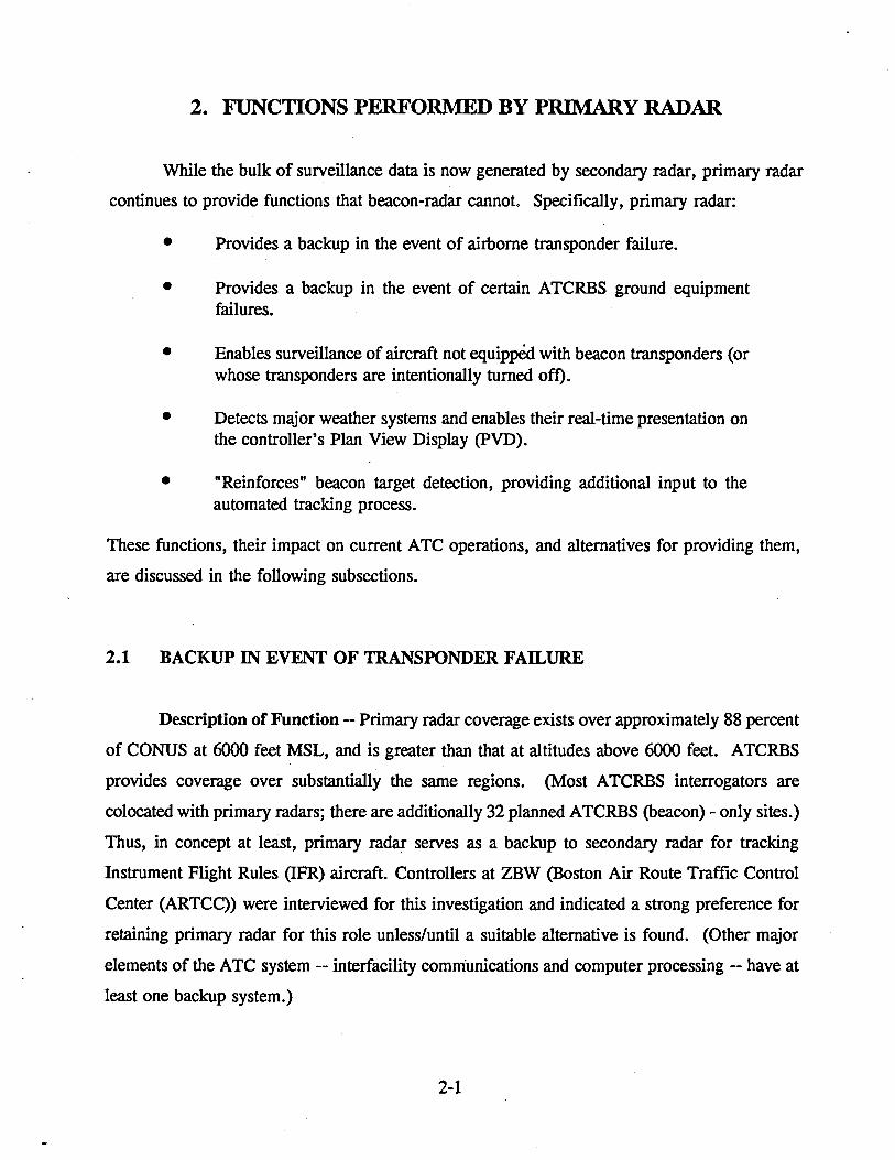
2. FUNCTIONS PERFORMED BY PRIMARY RADAR
While the bulk of surveillance data is now generated by secondary radar, primary radar
continues to provide functions that beacon-radar cannot. Specifically, primary radar:
• •
•
•
•
Provides a backup in the event of airborne transponder failure .
Provides a backup in the event of certain ATCRBS ground equipment failures.
Enables surveillance of aircraft not equipped with beacon transponders (or whose transponders are intentionally turned oft).
Detects major weather systems and enables their real-time presentation on the controller's Plan View Display (PVD).
"Reinforces" beacon target detection, providing additional input to the automated tracking process.
These functions, their impact on current ATC operations, and alternatives for providing them,
are discussed in the following subsections.
2.1 BACKUP IN EVENT OF TRANSPONDER FAILURE
Description of Function -- Primary radar coverage exists over approximately 88 percent
of CONUS at 6000 feet MSL, and is greater than that at altitudes above 6000 feet. ATCRBS
provides coverage over substantially the same regions. (Most ATCRBS interrogators are
colocated with primary radars; there are additionally 32 planned ATCRBS (beacon)- only sites.)
Thus, in concept at least, primary radar serves as a backup to secondary radar for tracking
Instrument Flight Rules (IFR) aircraft. Controllers at ZBW (Boston Air Route Traffic Control
Center (ARTCC)) were interviewed for this investigation and indicated a strong preference for
retaining primary radar for this role unless/until a suitable alternative is found. (Other major
elements of the ATC system -- interfacility communications and computer processing -- have at
least one backup system.)
2-1

------------- -----------~-----------------
To investigate the frequency of use of primary radar backup, "hard" statistical data on
transponder failures was sought but not found. Interviews with controllers suggest that failures
are seen once a day (high side) to once a week Qow side) at an ARTCC. Transponder failures
are significantly more common in smaller general aviation craft, which generally carry a single,
relatively low-cost unit. Some military aircraft (e.g., the Navy P-3 series) also carry a single
older transponder which fails relatively often .
. Primary radar is not a full backup of the secondary; its coverage volume is somewhat
smaller due to performance difference, and the existance at beacon-only surveillance sites. The
difference in coverage altitudes is shown in Figure 2-1. Additionally, proper primary radar
performance depends on the aircraft being sufficiently large to produce a strong echo, and
generally being at a higher altitude than the minimum required for a beacon return. Also,
primary radar tracking is unreliable when an aircraft is in traffic, because it is difficult to "hold
track" when targets are maneuvering and closely spaced.
Primary radar surveillance can be critical in situations where transponder failure occurs
coincident with the pilot becoming lost. However, since these cases usually involve smaller
aircraft whose primary returns are too weak to maintain track, radar rarely aids in locating the
aircraft. A recent study9 determined that primary radar is instrumental in providing successful
assistance to an estimated 13 lost aircraft per year or 5 percent of all beacon and radar assists
and 1 percent of assists which were unsuccessful. Based on analysis of National Transportation
Safety Board (NTSB) statistics, the study concluded that deactivation of primary radar would
result in an increase in the accident rate involving lost aircraft of 0.06 per year, with best and
worst case confidence bounds of 0.01 and 0.3. That is, one additional accident each 18 years
would be expected, if primary radar services were not available, due to a pilot becoming lost.
It appears that this increase is so small because such accidents usually result almost wholly from
pilot inexperience, and are about as likely to occur whether the aircraft is transponder equipped
or not.
9)'esley, J. M. and Kitterman, R. W., Impact of Primtlry Surveillance Radar on Lost Aircraft Accident Rate in the En Route Environment, November 1991.
2-2

~
6,000 Feet • MSL or MEA
100,000 Feet • MSL
Figure 2-1. CONUS Radar Coverage (from NAS-SS-1000, Vol. 1, p. 59)

Alternatives -- Several procedures are currently available for coping with transponder
failure in IFR aircraft, depending on the circumstances. If navigation capability is not impairt:d,
noriradar separation techniques can be employed with pilot voice-reporting of position. Pilots
can revert to Visual Flight Rules (VFR) if appropriate. When the aircraft is lost, direction
finding (DF) using communications signals is often effective. Presently there are 245 sites in
the DF network, and an additionall25 are being installed.
In the future, improved/additional aircraft equipage can provide alternative backup
techniques. For example, more reliable and/or redundant transponders may be developed/
required. ADS, the automated version of voice-reporting of position, may become available.
The key to its acceptance by recreational users will be avionics costs. Current low-end
transponder cost, approximately $1000, is a desirable goal.
2.2 BACKUP IN EVENT OF INTERROGATOR FAILURE
Description of Function -- Failure of the ATCRBS ground equipment could cause total
loss of secondary-radar-derived surveillance data. Should this occur, primary radar can serve
as a backup to secondary radar for tracking IFR aircraft. It is believed that this situation -
failure of the secondary while the primary remains operational-- occurs only rarely. One reason
is that ground-based ATCRBS installations are dual-redundant. Also, since many critical
components are common to both primary and secondary radar (e.g., antenna pedestal and drive,
rotary joint, digitizer, prime power supply, communications), there is a high likelihood that a
failure which causes loss of ATCRBS coverage will also result in loss of primary radar
coverage. Moreover, the need for such a backup capability may not be strong: much of CONUS
airspace already has coverage by at least two radar sites.
Alternatives -- An alternative to primary radar for this function is use of
additional/redundant secondary radars (this is believed to be a common practice in Europe).
Beacon radars provide better surveillance data than search radars. They are also cheaper to
purchase ($3.5M monopulse radar vs. $10M (esq primary radar) and maintain. In the future,
ADS or possibly CIS may serve as alternatives.
2-4

2.3 NONCOOPERATIVE AIRCRAFf DETECTION
Description of Function-- Noncooperative aircraft may be divided into two classes -
those attempting to evade detection and those which simply do not have a transponder. Relative
to the first class, air-search radar was first developed by the military for the detection of non
cooperative (in that case, hostile) aircraft. This function is still important, and now extends to
other than hostile military aircraft (e.g., drug smugglers). A new generation of long-range
radar, the ARSR-4, is being developed for this purpose, with enhanced ability to detect small,
slow-moving and low-altitude aircraft. ARSR-4 output (search and weather) will be fed both
to ARTCC centers for ATC and to military regional control centers to support the air defense
and drug interdiction missions. FAA has no requirement to further support the latter missions,
nor do current plans call for en route radars other than ARSR-4s to furnish surveillance data for
non-ATC functions.
The other class of noncooperative aircraft belong to general aviation operators who do
not have a transponder (primarily for cost reasons). While all aircraft operating under IFR carry
transponders, and Federal Aviation Regulations (FARs) regularly reduce the regions of airspace
in which nontransponder operation is permitted, a significant fraction of the U.S. aircraft fleet
(about 30 percent of general aviation in 1992) is nonequipped. Most of these aircraft operate
only in sparsely populated airspace, at low altitude. The separation services FAA provides to
IFR and cooperating VFR aircraft include advisories on these aircraft where possible. However,
current primary radar performance precludes routine tracking of nontransponder equipped small
aircraft, and without altitude or identity information the effectiveness of the advisory service is
at best minimal.
It is estimated10 that deactivation of the en route primary radars not part of the JSS
would remove non transponder aircraft surveillance coverage between 6000 feet (minimum radar
coverage altitude) and 10,000 feet (maximum altitude for nontransponder aircraft) over 33
percent of the CONUS. The remaining 67 percent of the CONUS would either continue to be
covered by terminal or JSS radars, or does not now have coverage. (The contemplated
deactivation would also remove coverage for· some regions above 10,000 feet. While
10Yesley, J .M., and Kitterman, R. W ., Effect of Pri11Ulry Surveillance Radar on Mid-Air Collision Risk in the En Route Environment, November 1991.
2-5

nonequipped aircraft are not authorized to be in these areas, occasional blunders do occur.)
Without primary radar, controllers would no longer be able to provide advisories to IFR aircraft
concerning the presence of VFR traffic in these regions. The referenced study considered 23
mid-air collisions over a 7-year span, and found that: the great majority (17) occurred below
6000 feet; and of the remaining 6 collisions, 4 were VFR/VFR. It predicts that shutting down
en route radars will cause a negligible increase in the rate of IFR/VFR mid-air collisions (one
additional accident in the next 30 years).
Since non transponder operation is less constrained by the International Civil Aviation
Organization (ICAO) regulations than by FAA regulations, nonequipped aircraft are occasionally
also seen in offshore airspace, within FAA radar coverage. As seen in Figure 2-2, all23 mid
air collisions studied occurred outside the proposed shutdown area. Virtually all such airspace
ma ~NoCovcra&eNow
rm~~83 primaJy radatll
- dc-actival<>d
• En Route Mid-Air
Colliai"""
Altitude Distn"buti011 of Mid-Air Collisions
Altitude Number ofT""" of Collisiooo
> 10,000 ft I VFRNFR 6QOO..IO,OOO ft 2 VFRIIFR, 3 VFRNFR < 6000 ft 16 ~I VfRIIFil
Figure 2-2. FAA Primary Radar Coverage at 6000 ft MEA
2-6

will continue to receive primary radar coverage (with ARSR-4s), as part of the air defense
mission, and primary target data from these radars will continue to be used by the FAA.
Alternatives -- There is no alternative to primary radar for surveillance of aircraft intent
on evading detection. However, in the case of benign, nonequipped aircraft, administrative
rulemaking can lessen the need for primary radar. First, the FAA can continue to encourage
transponder equipage by generally limiting the airspace where nonequipped aircraft may
operate. Second, if separation of equipped and nonequipped aircraft is deemed critical in some
of the regions of airspace where the latter are still allowed, then rulemaking which prevents their
operation in those regions is an appropriate action. The inability of primary radar to track small
aircraft reliably or determine their altitude makes it far less effective than ATCRBS in this
application.
2.4 WEATHER DETECTION
Description of Function -- The process by which primary radar video are digitized for
transmission to the center includes a limited capability to detect weather systems of sufficient
intensity. Returns from a region of airspace attributed to "moderate" precipitation are displayed
on the controller's PVD as a series of adjacent radial lines over the entire region of the weather
system. "H"s are placed adjacent to the lines if the weather is deemed "heavy" (this is termed
"two-level" weather capability-- see Figure 2-3). Because of its relatively long wavelength,
L-band search radar gives only a rough indication of the shape, size and intensity level of
weather systems. Controllers report frequent discrepancies between search radar-derived
weather information and observations by pilots and national weather service radar reports.
Typically these discrepancies are "false alarms" caused by ground clutter for lower beams or
relative to precipitation in reasonably small areas -- either stand-alone on the periphery of large
areas of actual precipitation. An additional drawback is that weather messages from pre-ARSR-4
search radars do not have altitude discrimination (the same vertical antenna pattern used for
aircraft search is also used for weather).
ZBW controllers were interviewed concerning the utility of primary radar weather
information. They consider current on-screen weather data only useful enough to give them a
general indication that "something's out there." These controllers rely on other sources to
2-7

-~------------------------------~--
Figure 2-3. ARSR-Derived Weather Data on Controller's PVD
characterize the disturbance, and often suppress the display of "moderate" intensity weather.
Some of the more experienced controllers lamented the loss of primary radar broadband analog
video data (which was provided to the centers until the mid-1980s). With wideband video,
controllers were able to reliably determine the outline of a region with intense weather, and thus
make more efficient use of the airspace.
Alternatives -- Several FAA and joint agency programs currently in progress are
developing national weather data products based on inputs from NWS radars and other sources.
When available, 11 these weather products are expected to be far more extensive and accurate
than ARSR-derived weather data. (There is sQme concern regarding the timeliness of new
11Some near-real-time data is currently available commercially, and FAA now provides such data to centers; however, these data may only be viewed on separate (color) displays which are not readily accessible to all controllers.
2-8

weather data products-- see below.)
The time-frame in which improved weather information will be available at the
controller's workstation is not certain. NEXRAD, a primary sensor for the improved weather
products under development, will not be fully deployed until1998. However, the mechanisms
for creating data products, particularly the 23 Regional Aviation Weather Product Generators
(RA WPG) and the associated distribution network, the Real-time Weather Processor (RWP), will
not be completed until2008. Moreover, the Advanced Automation System (AAS), the program
under which new controller workstations capable of accepting and displaying RWP data, the
Area Control Computer Complex (ACCC), is currently undergoing high-level review. Since it
is not prudent to remove the current capability for providing real-time weather information at
the controller's workstation without providing a replacement, these dates (availability of RWP
and ACCC or replacement) are critical to the shutting down of primary radars.
Concern has been expressed regarding the timeliness (latency) associated with new
weather data products, which will be presented to controllers in the future. While ARSR
derived data currently available is mediocre in quality, at least the controller can be assured that
what he/she sees is representative of the current precipitation situation. Conversely, the
NEXRAD radars, which are scheduled to provide precipitation data in the future, can take over
5 minutes to revisit a portion of the airspace volume; however, NEXRAD data are expected to
be significantly more accurate than ARSR data. The National Center for Atmospheric Research
(NCAR)12 is presently conducting tests, at the direction of the FAA, to establish performance
differences between ARSRs and NEXRAD, in terms of detectability and time delay (latency),
and determine the effects of these differences on ATC system operation. Initial results are
pending, and should be taken into account in decision-making regarding primary radar retention.
In the event that the ACCC installation date is later than can be tolerated for shutting
down the non-ISS primary radars, or the ACCCs are cancelled as part of a restructuring of the
AAS, it may be possible to define an "interim en route weather data improvement" project which
would result in acceptable quality real-time weather data being available at the controller's
workstation. The source of the data could be the·NWs radars now in service (but scheduled to .
be replaced by NEXRAD). NWS data could be transmitted to centers over commercial or
'WCAR ASRINEXRAD Comparison Study, Dr. B. Carmichael, NCAR (unpublished).
2-9

government telephone lines (meteorological data from six NWS sites is now transmitted to
ZBW). The AAS ISSS consoles might serve as the display device. A more detailed
investigation is required to validate this concept.
2.5 AUGMENTATION OF ATCRBS DATA
Description of Function -- Primary radar data is now reported to ARTCC automated
tracking/surveillance processes in two forms by the digitizer:
•
•
If a primary report does not correlate in position with a beacon report, it is reported as a "primary target," and its range and azimuth are provided. Center automation does not form tracks on such data, although controllers can force its tracking if they wish. A primary target is usually just displayed as an "x" on each scan, if tracked, and a "+ •• or a "." if not tracked, depending on its intensity.
If a primary target correlates with a beacon target, the primary target report is not sent. Rather, a bit is set in the beacon target report to indicate "radar reinforcement."
Because secondary radar "false targets" are not uncommon, in instances where the controller has
some uncertainty concerning a target, he/she can employ the reinforcement bit as another
information source.
Alternatives -- Software-based processing techniques for reducing the incidence of
beacon false targets have been developed, although none is implemented in an ARTCC. Since
false targets are often the result of multipath, one effective technique involves mapping of the
reflectors and associated multipath geometri~s into the track processing function for each radar
site, and checking whenever the same beacon code appears twice on a scan (when this occurs,
the location of one of the target reports is checked for consistency with one of the reflecting
surfaces and the location of the other report). This process has been demonstrated in terminal
processing software, is currently being implemented in upgrade ASR-9 beacon processing logic,
and will be incorporated into ModeS.
2-10

3. EQUIPMENT INVOLVED AND COST IMPACT
This section addresses equipment- and cost-related issues involved in shutting down the
FAA's FPS-20, ARSR-1, ARSR-2 and ARSR-3 primary radars. Subsection 3.1 provides a
general description of the equipment expected to be involved in the shutdown. Subsection 3.2
addresses the specific equipment modifications required if the current primary/secondary sites
are. to become beacon-only sites. Subsection 3.3 provides information on the Remote
Maintenance Monitoring System (RMMS). Subsection 3.4 provides rough cost estimates for the
elements ("pieces") involved in a primary radar shutdown. Lastly, Subsection 3.5 combines the
element costs and estimates the overall cost savings which would be achieved by shutting down
the non-JSS search radars.
3.1 RADAR SITE EQUIPMENT DESCRIPTION
3.1.1 AN/FPS-20, ARSR-1 and ARSR-2
The FAA has acquired/purchased several generations of en route primary radars, and
systems (installations) from each generation are still in service. During the 1940s, when radar
surveillance began, the United States Air Force (USAF) procured the AN/FPS-20; subsequently,
the USAF provided these systems (or data from these systems) to the FAA. Beginning in 1956,
the FAA purchased Air Route Surveillance Radars (ARSRs) specifically designed for aircraft
separation. A block diagram of a typical tube-type system (AN/FPS-20, ARSR-1, ARSR-2),
is shown in Figure 3-1. The National Airspace System (NAS) currently includes 29 AN/FPS-
20s and 47 ARSR-1s and -2s (76 altogether).
A secondary radar is collocated with each primary radar, a practice which began when
secondary radar was first installed, in the 1950s. At the radar site, analog data from both the
primary and secondary are processed by the Common Digitizer (CD) module, essentially
independently. (At this time, one of the CD-2 family of digitizers is installed at most sites.)
The radar scanning characteristics -- approximately one 360 deg rotation in 12 sec and 300
transmitted pulses each second -- result in multiple "hits" (approximately 30) on each target
during one revolution. The CD-2 combines echoes from these "hits" into a single target report
3-1

IRMM: Initial Remota Maintenance Monitor RMM: Remota Maintenance Monitor MPS: Maintenance Processor Subsystem DRG: Data Ravcaiver Group MIG: Military Interface Group PAM: Peripheral Adapter Module RMUX: Radar Muliplaxar SMMC: System Maintenance Monitoring Canso I• DARC: Direct Access Radar ChaMII CCCH: Central Computer Complex Hast
CDC: Computer Display Channel
Figure 3-1. Block Diagram of FPS-20, ARSR-1, or ARSR-2 Site
(a digital message) which is forwarded to the center over landlines and/or microwave links.
When the primary and secondary reports are considered to be in agreement, only the secondary's
message is sent, with a "radar reinforcement" bit set to signify agreement. The CD-2 also
identifies primary radar returns which appear to be due to precipitation, and constructs a polygon
description of the affected area. This polygon is transmitted back in a third type of message,
in addition to the primary and secondary aircraft target messages.
Typically, there are redundant transmission routes from each radar site to each destination
center. (Information from radar sites near the periphery of an ARTCC service area are often
sent to both the "owner11 center and the nearest adjacent center. Adjacent centers are also
3-2

linked, providing another backup communications path). At each center, the digitized radar data
are processed by the CCCH (Central Computer Complex Host, or simply "host"). The results
are ultimately displayed on the controller's PVD. The DARC (Direct Access Radar Channel)
serves as a backup to the host.
Several upgrades to the AN/FPS-20 and ARSR-1 and -2 series radars have been and
continue to be implemented. The common digitizer is in fact an enhancement to the original
installations ($40M program). Initially, primary radar analog data, termed wideband video, was
transmitted to the centers. After the introduction of digitizers, both wideband analog and digital
data were sent to the centers. Since approximately 1985, only digital data has been
communicated to off-site locations. Another important upgrade to these radars is the SSR/DMTI
(Solid-State Receiver Digital Moving Target Indicator) capability, which identifies targets with
a velocity component toward or away from the radar. In the region close to the radar
transmitter, where returns from ground clutter are strong, only nonzero velocity Doppler targets
are displayed. The SSR/DMTI program has already been completed.
3.1.2 ARSR-3 and ARSR-4
The ARSR-3 (see Figure 3-2) is a more modern radar than those addressed above, being
developed in the 1970s. It is functionally similar to the FPS-20s and ARSR-ls and -2s, but
employs more solid-state circuitry and uses a built-in data extractor rather than a common
digitizer. Twenty-three ARSR-3s are currently in service-- a fraction of the number of the older
tube-type units. Thus there are a total of 113 pre-ARSR-4 en route primary radars in the NAS
today.
The existing radars require additional upgrades to meet FAA needs. One planned
upgrade, the Remote Monitoring and Maintenance/Three-Level Weather (RMM/3LW), will
improve the weather discrimination capability from the current two levels to three levels.
(Initially, the ARSR-4 will provide three levels t~ controllers from the six available levels; all
six levels will be used later for the Area Control Facility (ACF).) Another upgrade is the
addition of RMM, which will allow maintenance personnel to access information concerning the
equipment "health" without making an on-site visit.
3-3

TheARSR-3
• Emervency Power Dies~l Gttnerator 81dg :::1 Prehbriell1ed Melel Buildings 3 T!ensformers 4 Geodesic Aadome, 57.5·11 Diameter S Alrcrafl Warning Lights I lightning Rod f Omrri·DlreclionaiSrec:on Anltonna I AeUector t lntegrauut BeacOI'I Radar FHd Anay
1(1 Wal .. way 11 Dual Driwe Motors 12 Rolaty JDinl
t3 Wa•egulde 14 12.5·11 Mod ~.liar Sll!clionfll Sleet Tower IS WavtoguldelnSlairwetl 16 Air CondiUoner 17 Air Conditioner 11 He~tl Eachangers tt Maintenance Of$play 20 R~tealver Ptocessar 21 Klystron Tubes 22 Transmitter Modulator Cabinets 23 Burh!ld FueiTanlt 2t EG Lead Banlt
----·----·
·--
Figure 3-2. ARSR-3 Standard Configuration
The ARSR-4 development program-- a joint FAA/DOD effort-- is currently nearing
completion (testing is ongoing). This modem radar is the first FAA system to employ solid-state
transmitter technology, three-dimensional imaging, pulse compression, and other advanced signal
processing techniques. Thirty-eight ARSR-4s will be deployed along the coast of the U.S.,
where they will provide both air defense and air traffic control surveillance capabilities.13
ARSR-4s are compatible with the Advanced Automation System software currently being
developed for the centers and with the Area. Control Facility future reconfiguration of the
National Airspace System.
As the ARSR-4 is installed over the next few years, 10 of the existing ARSR-3 radars
replaced by it may possibly be relocated ("leapfrogged") to current AN/FPS-20 and ARSR-112
sites, and the radars now installed in these sites may be scrapped. Table 3-1 summarizes the
en route primary radar system as envisioned by the CIP in the year 2000.
13Four additional ARSR-4's are scheduled for installation at the FAA Academy (Oklahoma City, OK), and at naval installations on Hawaii, Guam, and Cuba.
3-4

Table 3-1. Planned En Route Primary Radars in the Year 2000
I TYPE I NUMBER I COMMENTS
AN/FPS-20 60 Have been modified for SSR/DMTI, CD-2C; Planned upgrade ARSR-1 for 3-level weather, RMM; Additional upgrade required for ARSR-2 ACF/AAS compatibility
ARSR-3 23 Modifications in progress for 3-level weather, RMM
ARSR-4 42 All fully compatible with ACF/AAS
3.2 EQUIP:MENT INVOLVED IN SHUTDOWN
3.2.1 Mechanical/Structural Issues
At an en route radar site, the secondary radar antenna is generally either mounted on the
larger primary antenna or chin mounted. Many sites employ NADIF (NAFEC Dipole Fix)
secondary surveillance antennas, which are integral to the primary radar antenna and make use
of its reflector. The entire antenna structure is enclosed in a hemispherical radome. The search
and beacon radar electronics are housed within or beneath the tower. The beacon electronics
require one equipment rack; the remainder of the equipment (several racks) are devoted to the
search radar, digitizer, and other common equipment.
Based on engineering judgment and discussions with FAA personnel, conversion of a
dual-radar installation to a beacon-only site is expected to involve the following mechanical and
structural changes:
• Removal of primary radar electronics from the equipment room.
• Removal of the radome.
• Replacement of the common pedestal, primary radar antenna and secondary radar antenna by a new secondary antenna, capable of operation without a radome.
3-5
I

Two types of Mode S antenna are currently in procurement, intended for terminal and
en route radar installations. The terminal radar Mode S antenna will be mounted on top of an
ASR primary "sail", and so is weather-proof. It employs a 4 x 16 element open array, with a
conventional monopulse (sum and difference) pattern in the horizontal, and a fan-beam in the
vertical dimension.
The en route antenna is electrically similar to and roughly the same size as the terminal
one, differing primarily in its vertical illumination pattern. To concentrate its gain at the horizon
in order to provide maximum detectability at long range, it employs a cosecant-squared vertical
pattern rather than a fan-beam. Thus, the power-distribution networks in its individual vertical
columns have components of different values from those in the terminal antenna. Two such
antennas are to be employed at en route sites, under current plans, back-to-back. Since the
primary sail requires weather protection, a radome will be required, as it is now. Simultaneous
back-to-back operation of two Mode S/ATCRBS antennas in such close proximity leads to
potential mutual interference problems; to counteract these, the currently planned en route
antenna employs a much finer lattice structure on its back plane, which makes it also insuitable
for operation without a radome. The current radome degrades monopulse performance, so a
new one is being developed for use with ModeS.
If primary radar were to be removed from en route sites, considerable savings could
result by eliminating the radome if terminal antennas could be modified for that application. As
noted above, modification would consist primarily of changes to the vertical feed networks to
produce a cosecant-squared pattern rather than a fan beam. This appears attainable simply
through use of components (splitters, attenuators) of different value.
En route radar scan rates are currently limited by mechanical constraints involving
rotation of the large primary antenna. Replacing it with a secondary-only antenna would enable
scan rates similar to those of terminal radars, and hence would eliminate the need for back-to
back operation. (At a 5-second update interval (12 rpm), a maximum unambiguous range of 240
nm can be realized, at a prf of 330, with 16 hits on target. This is consistent with the reduced
fruit enviornment that will result from monopulse operation, and with Mode S data transmission
requirements.) The ability of existing processing software to operate at these changed parameter
values must be evaluated.
3-6

The costing discussions that follow therefore assume that a single antenna is employed
at each secondary-only en route radar site, similar to a terminal radar ATCRBS antenna, with
no radome.
The large pedestal now in use, which supports the massive primary antenna, requires
frequent and sometimes extensive maintenance. (As part of scheduled maintenance, 15 to 18
pedestals are overhauled each year. Another 8 to 10 emergency repairs are performed
annually.)14 A smaller pedestal, sized to the lighter beacon antenna, would be less expensive
to construct and maintain, and could readily accommodate the higher scan rate.
3.2.2 Electrical Issues
Electrically, the primary and secondary radars are largely independent, as they must be,
since secondary radars are sometimes deployed separately at so-called "beacon-only" sites.
There are, however, three interfaces between the two that must be considered in converting a
site to beacon-only operation (see Figure 3-3). These areas, and their resolution, are:
•
•
•
Beacon Trigger-- In dual sites, beacon transmissions are triggered from the primary radar. However, the beacon can be made to self-trigger by providing an appropriate timing source.
Common Digitizer-- The CD-2 will operate properly without primary radar returns; however, azimuth inputs from the antenna structure must be retained.
Beacon Performance Monitor -- Can be retained without modification .
Put simply, there are no significant electrical issues associated with converting a dual radar
installation to a beacon-only site.
14 CIP 44-43
3-7

Beacon Beacon Video
Radar Receiver and Timing Equipment Beacon Mode Pair Triqaer
ACP DataSet
Antenna Data1 Modem Azimuth Data ARP Transmitter Equipment Clock1 Svnchro #1
1------CD-2 Data2 Modem Beacon (All Types)
Beacon TestTarqet Pulse Transmitter Test Clock2 Set #2
1------Active Channel Data3 Modem On-line Beacon Alarm
Clock3 Transmitter
#3 Radar Beacon Standby Beacon Alarm
Performance On-line RBPM Alarm Monitor
Return
Figure 3-3. Data-Flow at Beacon-Only Site (Non-ModeS)
3.3 RMMS SYSTEM
To ARTCCs
ACFs
The next generation Remote Maintenance Monitoring System (RMMS) planned for the
ARTCC Maintenance Control Center (AMCC) and the General NAS/MCC (GMCC) will have
a single Maintenance Processor Subsystem (MPS) located at ARTCC/ ACF will service both the
AMCC and GMCC. For RMMS purposes, the Interim Maintenance Control Software (IMCS)
will continue to provide the maintenance functions for the ARSR-1, -2, -3 and the FPS radar
systems until the Maintenance Control Software (MCS) is checked out. The discrete data
associated with these radars will be acquired from the MPS by the Data Acquisition Subsystem
(DAS) for display by the Real-time Status Display (RSD).
3-8

3.3.1 IMCS Transition Plan to MCS
At present, the IMCS software is operating with the ARSR-3 and the ARSR-1, -2 and
FPS radars upgraded with the new CD-2 modifications. The MCS software for the next
generation RMMS is being written at present.
The new replacement radars, namely ModeS and ARSR-4, will not be supported by
IMCS until the IMCS DECODER processor for each radar is written. (The IMCS DECODER
receives raw digitized data from the radars' sensors and reformats the data into a common data
form for storage in the IMCS database file). In order to support the transition plan it is required
that the IMCS software be included with the new MPS system. IMCS will continue to be
included as part of the new MPS until the MCS software is operational.
3.3.2 Impact of Primary Radar ~hutdown on Radar Maintenance
The impact on radar maintenance· caused by shutdown of the primary radar within the
ARSR-1, -2, -3 and FPS is as follows:
Radar Site.
• The Remote Control Interface Unit (RCIU) RMS software for the primary radar will be deleted. Any dependency of the secondary radar on the primary radar data information will be removed.
• CD-2 interfaces with the primary radar sensors will be removed.
• Maintenance Data Terminal (MDT) software to service the primary radar will be deleted and will include only the secondary radar.
• RMS timing for Primary to Secondary radars is to be redefmed, i.e., Startup, Restart, On, etc. (Timing is initiated from the primary radar.)
AMCC Site.
• The software interface for the performance evaluation tests of ARSR and FPS radars will be reexamined and modified to include only the secondary radars.
• SDR flles will be purged to exclude the primary radar.
The least affected by the shutdown of the primary radars is the MPS software.
3-9

Another aspect that must be investigated is whether the RMS modifications to the ARSR-
1, -2, -3 and FPS, as part of a change to a secondary-only radar system, would adversely impact
or support the transition plan to install the next generation Mode S radar systems.
3.4 ESTIMATED ELEMENT COSTS/SAVINGS
This subsection presents rough cost estimates for the elements involved in shutting down
older primary radars. These elements include:
• Costs of modifications to convert a dual-radar installation to a beacon-only site (Subsection 3.4.1). This includes removal of old equipment and site cleanup. Installation of new Mode S beacon equipment is funded separately.
• Savings realized from cancelling ongoing CIP projects directed at modernizing installed primary radars (Subsection 3.4.2).
• Savings due to reduced maintenance of the en route radar sites (Subsection 3.4.3).
Estimated total costs, formed by aggregating the individual cost elements, are provided in
Subsection 3.5. Note that estimates presented herein do not include the costs of associated
systems which replace the functions now provided by primary radar (e.g., additional beacon-only
sites, ADS). To the extent that such programs are undertaken or expanded to facilitate shutting
down primary radars, their associated costs could be "charged against" the shutdown. Since the
nature of such programs is at present unknown, it was not possible to estimate their costs.
These should properly be included in the total when known.
3.4.1 Radar-Site Modifications
As described above in Subsection 3.2.1, modifications associated with converting a dual
radar installation to a beacon-only site are expected to involve: (1) removal of primary radar
electronics from the equipment room; (2) replacement of the common pedestal, primary radar
antenna and secondary radar antenna by a less massive pedestal and a new secondary open-array
antenna capable of unprotected operation; and (3) removal of the radome.
Based on discussions with FAA personnel, the estimated cost for these activities is
between $1. OM and $2. OM per site and therefore an average value of $1.5M per site is used
herein.
3-10

While site-modification cost estimates cannot be precise, because of different conditions
at each site, they appear to be reasonable when contrasted with the costs for some of the systems
involved. For example, the equipment cost for an ATCBI-5 secondary radar with an open array
antenna is approximately $3.16M, the cost for an en route site radome has been estimated as
$550K, and a full dual-antenna ModeS installation (with radome) costs $4,84M.
3.4.2 Capital Investment Plan (CIP) Projects
Several CIP projects address en route primary radars, either entirely or in part. These
projects, and the associated budgetary figures which relate directly to the postulated shutdown,
are summarized in Table 3-2. The total cost for the full and panial projects listed is $336.0M
(sum of the amounts in the right-hand column). If an immediate shutdown of older en route
primary radars were to occur, these costs could be foregone.
PROJECT
24-15
44-39
44-40
44-42
44-43
Table 3-2. CIP En Route Radar Program Costs (FY -93 Cost Estimates)
NAME I DESCRIPTION AMOUNT
Long-Range Radar (LRRJ Program $34.6M 10 ARSR-3 "leapfrog" relocations LRRs relocated as required (39 ARSR-4s being procured not included in "amount")
Relocate Air Route Surveillance Radars $56.7M Approximately 2 sites/year to be relocated
Long-Range Radar Improvements $186.2 Improvements to older LRRs: controls for ARSR-1 and -2s, cable trays cleaned-up, grounding upgraded
Long-Range Radar Radome Replacement $31.0M Replace radomes at all existing LRR sites: most are 25 to 30 years old (signal distortion and maintenance are issues), and will not accommodate taller ModeS antenna
Radar Pedestal Vibration Analysis $0.5M Install vibration sensors and analysis equipment, in order to better manage maintenance activities
Solid State Transmitter $27.0M
Total: $336.0M
3-11
3.4.3 Primary Radar Maintenance
Current FAA expenditures for maintenance of older en route sites are as follows: for all
43 AN/FPS-20 sites, $0.9M per year (not including DOD costs) and for all47 ARSR-1 and -2
sites, $2.8M per year. Costs for 23 ARSR-3 sites were not found, but are estimated to be
$0.8M per year. A breakdown for the primary and secondary radars and common equipment
was not available. However, based on its significantly larger size and higher transmitted power,
it is expected that most of the cost can be attributed to the primary radar. Thus, an upper bound
on the cost of maintaining the current primary radars is $4.5M per year.
3.5 ESTIMATED TOTAL SAVINGS
From Section 3.4, it is clear that, in the long run, savings (based on foregone
expenditures for radar upgrades and annual maintenance) can be achieved by shutting down the
interior CONUS primary radars. However, in order to calculate total savings, a time-frame
must be selected. (On the one hand, shutting down primaries in one year will cost more that
it will save in that year. On the other hand, a very long time-frame, which will result in large
predicted savings, is not realistic because conditions change too much.) For cost estimating
purposes, the time-frame selected is the present to the year 2008. In 2008, real-time weather
from new programs (NEXRAD, RAWPG, RWP, AAS) will be available to controllers,
replacing an important primary radar function for which there is no present alternative. Also,
by 2008, alternatives to primary radar for aircraft surveillance (increased transponder equipage,
ADS) will be available.
Shutting down interior CONUS primary radars immediately, rather than in 2008, will
involve the following costs:
• $124.5M Expenditures-- for modifying 83 sites, at $1.5M per site.
• $336.0M Savings- foregone expenditures for CIP projects in Table 3-2.
3-12

• $67.5M Savings-- foregone expenditures for maintenance over 15 years at $4.5M per year. 15
The net savings associated with an immediate shutdown is $279.0M over 15-year planning
horizon, or an average of $18. 6M per year.
ISDoes not include potential watchstander- elimination savings, estimated at $18.7M per year.
3-13/3-14

--------------------

4. CONCLUSIONS
Table 4-1 presents a summary of the functions performed by primary radar. Functions
are listed in order of decreasing value to the ATC system, together with possible alternative
systems/procedures and the expected date of availability for the alternatives. The first two
functions -- detection of real-time weather and non transponder aircraft -- are used by controllers
every day. The third function -- backup for failed transponders -- is employed on average
perhaps once a week (based on anecdotal data). Controllers at ZBW expressed a strong desire
to retain primary radar for these three functions. It appears that the fourth and fifth functions -
- backup in the event of ATCRBS ground equipment failure and enhancement of secondary radar
data -- could be eliminated without significant loss of ATC capability.
Table 4-1. Summary of En Route Primary Radar Functions
I FUNCTION I NEED I ALTERNATIVES I AVAILABLE
Real-Time Weather High to NEXRAD/RWP/AAS 1998-2008 Detection Medium New focused program not planned
Nontransponder Aircraft Medium Increased transponder equipage 2000 Detection to Low ADS (or later CIS) unclear
Backup for Transponder Medium Voice position report now Failure to Low Communications direction finding now
VFR operation now
Backup for ATCRBS Low Additional secondary sites not planned Ground Equipment Failure ADS (or later CIS) unclear
Improvement of Low Processing improvements some in Mode S Secondary Data
FAA WJH Technical Center IIIIIIIIIIIIIII/IIIIIJIIIIII//1/IIIIIIIIIIIII//III
4-1
00093516
I

A compelling, documented case for retaining primary radar to perform the first three
functions is not evident. On the one hand, primary radar does not perform any of these
functions extremely well. The primary radar weather capability is mediocre (two levels of
precipitation and tends to overestimate activity with no altitude discrimination). Moreover,
credible studies predict that the number of additional accidents which would result from removal
of the radars would be almost insignificant: one additional IFR/VFR mid-air collision in the next
30 years (relates to second function), and one additional accident due to a pilot becoming lost
in the next 18 years (relates to third function). In total, one additional accident in the next 11
years would be expected.
On the other hand, shutting down the primary radars immediately (before most
replacement systems are on-line) would result in an overall loss of ATC surveillance capability.
That is, an immediate shutdown would_ result in a decrease in the margin of safety. While the
"bottom-line" measure of ATC performance-- accident rate-- might increase by only a small
amount, some important intermediate level ATC performance factors, such as awareness of the
overall traffic situation and ability to prevent near misses, would likely be impacted to a greater
degree. The most prudent course of action appears to be to retain the primary radars until full
functional replacements -- i.e., systems which meet or exceed search radar capabilities -- are
operational.
If this tack is taken, availability of a replacement for the real-time weather capability will
be the governing factor in determining a potential shutdown date. The planned replacement
capability involves the NEXRAD weather radar sensor, RA WPG system for generating data for
the controller, RWP distribution network, and ACCC controller displays. Scheduled completion
for the RWP is 2008, and the AAS program under which the ACCCs are being developed is
currently undergoing review. It might be possible to define an interim system for providing
real-time weather to controllers from NWS radars using ISSS displays, and by doing that to
advance the potential shutdown date, possibly to 1998.
4-2
AAS ACCC ACF ADS AERA AMCC ARSR ARTCC ASR ATC ATCBI ATCRBI ATCRBS
CCCH CD CIP CIS CONUS
DARC DAS DF DMTI DOD DOT
FAA FAR
GHz GMCC GPS
ICAO IFR IMCS ISSS
JSS
GLOSSARY
Advanced Automation System Area Control Computer Complex Area Control Facility Automatic Dependent Surveillance Automatic En Route Air Traffic Control ARTCC Maintenance Control Center Air Route Surveillance Radar Air Route Traffic Control Center Aircraft Surveillance Radar Air Traffic Control Air Traffic Control Beacon Interrogators Air Traffic Control Radio Beacon Interrogators Air Traffic Control Radio Beacon System
Central Computer Complex Host Common Digitizer Capital Investment Plan Cooperative Independent Surveillance Continental United States
Direct Access Radar Channel Data Acquisition Subsystem Direction Finding Digital Moving Target Indicator Department of Defense Department of Transportation
Federal Aviation Administration Federal Aviation Regulation
Gigahertz General NAS/MCC Global Positioning System
International Civil Aviation Organization Instrument Flight Rules Interim Maintenance Control Software Initial Sector Suite System
Joint Surveillance System
G-1

MCC MCS MDT MPS MHz MSL
NADIF NAS NCAR NEXRAD nm NTSB NWS
PVD
RAWPG RCIU RMM RMMS RMS rpm RSD RTCA RWP
SSR
TASC TCAS
us USAF
VFR VHF
ZBW
Maintenance Control Center Maintenance Control Software Maintenance Data Terminal Maintenance Processor Subsystem Megahertz Mean Sea Level
NAFEC Dipole Fix National Airspace System National Center for Atmospheric Research Next Generation Weather Radar nautical mile National Transportation Safety Board National Weather Service
Plan View Display
--------------------~~---
Regional Aviation Weather Product Generators Remote Control and Interface Unit Remote Monitoring and Maintenance Remote Maintenance Monitoring System Remote Maintenance Software revolutions per minute Real-time Status Display Radio Technical Commission for Aeronautics Real-Time Weather Processor
Solid-State Receiver
The Analytic Sciences Corporation Traffic Alert and Collision Avoidance System
United States United States Air Force
Visual Flight Rules Very High Frequency
Boston Air Route Traffic Control Center
G-2

