improving the precision of high-rate gpsxenon.colorado.edu/larsonetal_2007.pdf · improving the...
TRANSCRIPT
Improving the precision of high-rate GPS
Kristine M. Larson,1 Andria Bilich,1 and Penina Axelrad1
Received 28 February 2006; revised 10 October 2006; accepted 28 December 2006; published 31 May 2007.
[1] In order to improve the accuracy of high-rate (1 Hz) displacements for geophysicalapplications such as seismology it is important to reduce systematic errors at seismicfrequencies. One such GPS error source that overlaps with seismic frequencies and is notcurrently modeled is multipath. This study investigates the frequencies and repetition ofmultipath in high-rate GPS time series in order to maximize the effectiveness oftechniques relying upon the geometric repeatability of GPS satellite orbits. Theimplementation of the aspect repeat time adjustment (ARTA) method described here usesGPS position time series to estimate time-varying and site-dependent shifts. Asdemonstrated for high-rate GPS sites in southern California this technique significantlyreduces positioning noise at periods from 20 to 1000 s. For a 12-hour time series,ARTA methods improve the standard deviation of the north component from 8.2 to5.1 mm and the east component from 6.3 to 4.0 mm. After applying ARTA corrections,common mode errors are removed by stacking. This method further improves the standarddeviations to 3.0 and 2.6 mm for the north and east components, respectively.
Citation: Larson, K. M., A. Bilich, and P. Axelrad (2007), Improving the precision of high-rate GPS, J. Geophys. Res., 112, B05422,
doi:10.1029/2006JB004367.
1. Introduction
[2] Our understanding of earthquakes requires first con-straining the kinematic and dynamic models of fault rupture.The ability to resolve ground motions accurately over arange of frequencies and amplitudes is critical to under-standing these processes. Several methods exist for resolv-ing ground motions, each with inherent strengths andlimitations. Accelerometers, for example, capture the detailsof strong ground shaking near the source, but it is difficultto convert the acceleration measurements unambiguously todisplacement. These problems are compounded for longperiods or when the accelerometer experiences strong orpermanent rotations. Broadband seismometers are moresensitive and have better resolution of ground motion butmay clip, saturate, or become nonlinear even to greatdistances from a large earthquake. Interferometric syntheticaperture radar (InSAR) observations can produce spatiallyrich images of some components of surface displacementsurrounding a rupture, but InSAR is prone to failure incertain regions and has insufficient temporal resolution toresolve short-term dynamic changes during an earthquake.GPS instrumentation has been important in earthquakestudies for resolving coseismic offsets, which places impor-tant constraints on the rupture process, but until recently,GPS observations were not sampled frequently enough tomeasure ground displacements associated with earthquakerupture.
[3] An increasing number of continuously operatingGPS receivers originally installed for long-term geophys-ical studies are now operating at seismic frequencies, e.g.,1 Hz. In situ experiments and comparative studiesdescribed by Ge [1999] and Ge et al. [2000a] indicatethat high-rate GPS can resolve large displacements in ashort-baseline environment. More recently, new studieshave shown good agreement between seismic and (1 Hz)high-rate GPS measurements [Elosegui et al., 2006; Wanget al., 2007; Emore et al., 2007]. Larson et al. [2003] used1-Hz GPS to observe large ground motions over continen-tal scales during the Denali Fault earthquake; Bock et al.[2004] showed relative measurements from southern Cal-ifornia for the same event. Following the Denali event,high-rate GPS data began to be used in seismic rupturestudies [Ji et al., 2004; Miyazaki et al., 2004; Langbein etal., 2005; Kobayashi et al., 2006] for earthquakes rangingin magnitude from M6 to 8. The high-rate GPS techniquebuilds on the basic tools and developments used in tradi-tional GPS analysis: precise orbits in a well-defined terres-trial reference frame, an expanded constellation of 29 GPSsatellites providing greater global coverage, and high-precision geodetic software. Unlike geophysical studiesthat average many GPS observations to compute oneposition per day [Segall and Davis, 1997], high-rateGPS analyses compute one position per epoch; precisionis therefore strongly affected by systematic errors. Forhigh-rate GPS applications such as seismology, methodolo-gies must be developed to reduce the influence of systematicerrors such as multipath on GPS position estimates. Thispaper describes howmultipath effects vary in GPS time seriesand describes methods for removing these effects. We sub-
JOURNAL OF GEOPHYSICAL RESEARCH, VOL. 112, B05422, doi:10.1029/2006JB004367, 2007ClickHere
for
FullArticle
1Department of Aerospace Engineering Sciences, University ofColorado, Boulder, Colorado, USA.
Copyright 2007 by the American Geophysical Union.0148-0227/07/2006JB004367$09.00
B05422 1 of 11
sequently assess the precision of high-rate GPS at periods of2–1000 s.
2. GPS Data Analysis
[4] The analysis of high-rate GPS data is common in real-time applications associated with navigation, surveying, andstructural monitoring. There are also a growing number ofhigh-rate GPS publications in the geophysical literature[Celebi et al., 1999; Bock et al., 2000; Melbourne andWebb, 2002]. Software developed for high-rate geophysicalapplications makes use of many of the same models usedfor 24-hour averages, but the estimation strategies are morevaried. For example, when 24-hour average positions arecomputed, most geodetic software estimates one phaseambiguity per satellite station arc [Blewitt, 1989]. Thiscan also be done in high-rate GPS studies [Larson et al.,2003]. In the high-rate positioning analysis strategy des-cribed by Bock et al. [2000] a new phase ambiguity isestimated at every data epoch. Subsequently, ambiguityresolution is attempted. One benefit of this strategy is thatit obviates the need to detect cycle slips; the weakness of thestrategy is that positions will be very poorly determined ifambiguity resolution is not successful. Demonstrations ofthis implementation of high-rate positioning [e.g., Mattia etal., 2004] have largely been limited to baselines less than20 km. Kouba [2003] describes a high-rate analysis strategythat uses the International Global Navigation SatelliteSystems (GNSS) Service (IGS) precise orbit and clockproducts [Beutler et al., 1994; http://igscb.jpl.nasa.gov].While Bock et al. [2000] double differences carrier phaseobservables to remove clock errors, Kouba [2003] interpo-lates from 5-min IGS satellite clock values and estimates thereceiver clock. Kouba’s [2003] strategy is computationallyefficient; because the data from each receiver are analyzedseparately, there is no restriction on baseline length.[5] In this study the GPS Inferred Positioning System
(GIPSY) software is used to analyze the GPS data [Lichtenand Border, 1987]. The IGS precise orbits, defined inInternational Terrestrial Reference Frame 2000 (ITRF2000),are used to define the coordinates of the GPS satellites[Beutler et al., 1994]. One station is used as the reference;
its position is constrained (a priori standard deviation of1 cm) to agree with its ITRF2000 position [Altamimi etal., 2002]. Although in theory any station in the networkcan be used as the reference site, any motion at that site(e.g., static or dynamic seismic displacements) must beaccounted for in the processing software; otherwise, allhigh-rate positions in the network will become relativepositions (corrupted by the reference site’s motion) ratherthan absolute positions. For all other sites, positions in alocal coordinate system (east, north, and vertical) areestimated every second with a loose a priori constraint(100 m). Other estimated parameters include satellite andreceiver clocks, constant zenith troposphere delays, andcarrier phase ambiguities. Ambiguities are resolved usingthe methods described by Blewitt [1989]. In this paper,only horizontal component precision will be discussed;high-rate GPS vertical positions are left for future work.Because of GIPSY software constraints, only 3.3-hourtime segments will be analyzed in one batch.[6] These analysis methods will be applied to data from
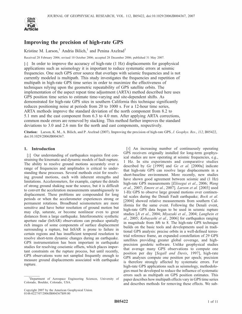
continuously operating GPS sites in southern California toassess the positioning noise characteristics of individualsites and the network as a whole. The sites (Figure 1) arepart of the Southern California Integrated GPS Network(SCIGN) [Hudnut et al., 2002]. This subset of SCIGN sitesoperates at 1 Hz. All use a common receiver/antenna(ASHTECH Z-XII3/choke-ring antenna) and many have asimilar monument design (drill braced with radome). Manyof the sites analyzed here were previously discussed byLangbein and Bock [2004]. We focus on high-rate GPS datacollected in the days before and after the Parkfield earth-quake, 28 September 2004, 1715 UTC.[7] Figure 2 illustrates the variation in noise character-
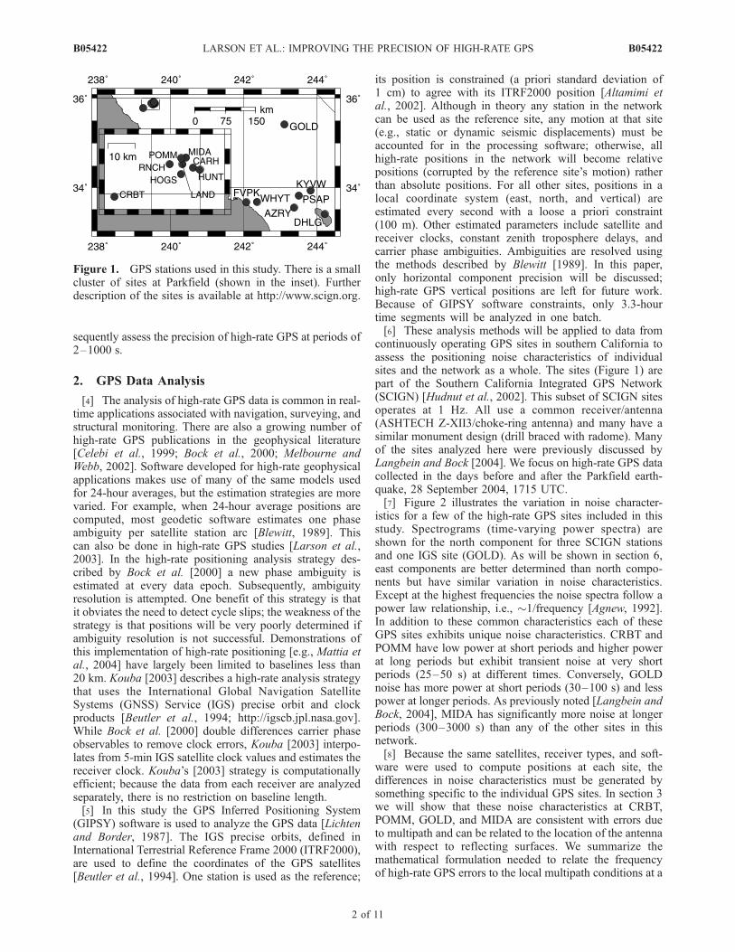
istics for a few of the high-rate GPS sites included in thisstudy. Spectrograms (time-varying power spectra) areshown for the north component for three SCIGN stationsand one IGS site (GOLD). As will be shown in section 6,east components are better determined than north compo-nents but have similar variation in noise characteristics.Except at the highest frequencies the noise spectra follow apower law relationship, i.e., �1/frequency [Agnew, 1992].In addition to these common characteristics each of theseGPS sites exhibits unique noise characteristics. CRBT andPOMM have low power at short periods and higher powerat long periods but exhibit transient noise at very shortperiods (25–50 s) at different times. Conversely, GOLDnoise has more power at short periods (30–100 s) and lesspower at longer periods. As previously noted [Langbein andBock, 2004], MIDA has significantly more noise at longerperiods (300–3000 s) than any of the other sites in thisnetwork.[8] Because the same satellites, receiver types, and soft-
ware were used to compute positions at each site, thedifferences in noise characteristics must be generated bysomething specific to the individual GPS sites. In section 3we will show that these noise characteristics at CRBT,POMM, GOLD, and MIDA are consistent with errors dueto multipath and can be related to the location of the antennawith respect to reflecting surfaces. We summarize themathematical formulation needed to relate the frequencyof high-rate GPS errors to the local multipath conditions at a
Figure 1. GPS stations used in this study. There is a smallcluster of sites at Parkfield (shown in the inset). Furtherdescription of the sites is available at http://www.scign.org.
B05422 LARSON ET AL.: IMPROVING THE PRECISION OF HIGH-RATE GPS
2 of 11
B05422
GPS site and then describe and evaluate a method thatremoves multipath errors.
3. Multipath
[9] GPS multipath occurs when the transmitted signalarrives at an antenna via an indirect path rather than alongthe direct path. In the context of this study, multipath iscaused by reflections from objects near the receiving antenna.A multipathed signal has a longer path length than a directsignal, introducing error to the pseudorange and carrier phasemeasurements, which then propagate into position solutionsbased on these data. Multipath may be either diffuse orspecular in nature. Specular multipath is problematic becauseit produces systematic, time-correlated errors that are noteasily treated by traditional analysis methods. In contrast,diffuse multipath takes on an unbiased, random appearanceand is more easily removed through filtering within thereceiver hardware. Various approaches for multipath reduc-tion and correction have been developed. In summary,one can avoid or reduce susceptibility to reflected signals[van Nee, 1992; Van Dierendonck et al., 1993; Schupler andClark, 2001], calibrate or evaluate the errors using assump-tions of spatial repeatability [Cohen and Parkinson, 1991], orestimate the multipath corrections from SNR data [Axelrad etal., 1996; Comp and Axelrad, 1998]. Modeling approachesthat use repeating orbital characteristics of the GPS constel-lation have also been suggested [Genrich and Bock, 1992;Ge et al., 2000b; Choi et al., 2004]; a new implementationof this methodology is discussed in section 4.
Figure 2. North component spectrograms for CRBT, POMM, GOLD, and MIDA, 26 September 2004,1520 UTC. The transient short-period multipath is circled in red. The scale bar gives power units in m2/Hzin dB.
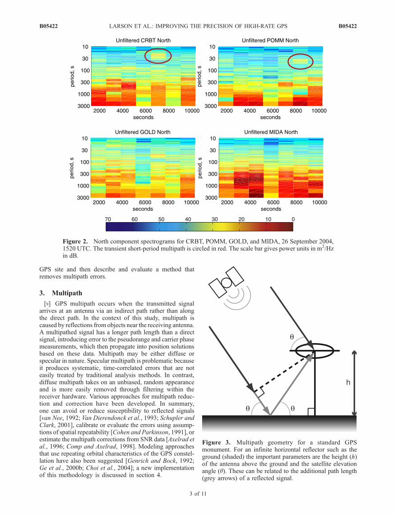
Figure 3. Multipath geometry for a standard GPSmonument. For an infinite horizontal reflector such as theground (shaded) the important parameters are the height (h)of the antenna above the ground and the satellite elevationangle (q). These can be related to the additional path length(grey arrows) of a reflected signal.
B05422 LARSON ET AL.: IMPROVING THE PRECISION OF HIGH-RATE GPS
3 of 11
B05422

[10] The most straightforward multipath case involvesspecular multipath where the GPS antenna is located abovean infinite horizontal reflector such as the ground (Figure 3).The time-dependent signature of multipath can best beunderstood by analyzing the frequencies inherent in multi-path errors; discussion in the rest of this section involvesonly carrier phase multipath errors since the more precisecarrier phase data are of greater interest to geodesists thanpseudorange measurements. For GPS carrier phase multi-path these frequencies can be expressed as a function of therelative phase (y), i.e., the phase difference between thedirect and reflected signals. The parameters that determinethe effect of reflected signals on the phase are the height ofthe antenna above the reflecting surface (h), the L1 or L2GPSwavelength (l), the satellite-receiver elevation angle (q), andthe reflecting characteristics of the horizontal surface(defined as the ratio (a) of the reflected signal amplitudewith respect to the direct signal). For the specific case of areflection from a horizontal surface the additional pathlength with respect to the direct signal (d) was shown byGeorgiadou and Kleusberg [1988]:
d ¼ 2h sin q ð1Þ
The corresponding relative phase and its time derivative aredefined as
y ¼ 2pdlþ yo ¼
4phl
sin qþ yo ð2Þ
dydt
¼ 4phl
cos qdqdt
; ð3Þ
where yo is a possible bias.[11] Converting the phase delay rate to the period for a
rising pass of a GPS satellite, Figure 4 summarizes multi-
path frequencies for a variety of horizontal reflector dis-tances (0.5, 1.5, 5.0, and 25 m). One can discern two majorfeatures of GPS multipath. First, reflections from a hori-zontal surface will generate multipath oscillations withshorter periods at low satellite elevation angles than athigh-elevation angles. Additionally, the gain pattern of mostGPS antennas results in larger a at low-elevation anglesthan at high-elevation angles. Thus, for high-rate GPSapplications at seismic frequencies, removing multipath atlow elevations (where magnitudes are large and periods areshort) will be of greater importance than at higher eleva-tions. Second, close horizontal reflectors produce longer-period oscillations, and far horizontal reflectors produceshorter-period oscillations. For large antenna heights theoscillations at low elevations will be close to the period ofseismic surface waves (20 s). These simple calculationsexplain why the GOLD spectrogram (Figure 2) showedsignificant energy at short periods: GOLD is attached to atower �25 m above the ground. In contrast, CRBT has itsantenna mounted�1.8 m above the ground and has a spectralsignature dominated by the longer periods (Figure 2). Thelarge long-period high noise levels at MIDA are believed tobe caused by multipath from a tree. The transient short-period multipath signals seen at POMM and CRBT are notcaused by an infinite horizontal reflector but more likely bya distant tilted surface that impacts only certain sections ofthe sky. More complicated derivations are required tounderstand the frequency of multipath reflections from atilted surface [Bilich, 2006] and are not given here. Overall,reflections from distant surfaces (horizontal or tilted) havethe potential to generate multipath at frequencies similar tothat of seismic waves. While much of the early research onmultipath at geodetic sites focused on near reflectors [e.g.,Elosegui et al., 1995], Figures 2 and 3 make it clear thatproperly correcting for far reflectors will be especiallyimportant for high-rate GPS applications where short-periodphenomena are of significant interest. Section 4 describeshow the daily repeatability of GPS orbits can be exploitedto mitigate the effects of both short- and long-periodmultipath.
4. Aspect Repeat Time
[12] The repeatability of multipath is contingent on therepeatability of geometric relationships between the satel-lite, receiving antenna, and the surrounding environment. Ifone can establish the period at which geometric relation-ships will repeat, a multipath correction profile can beconstructed from data collected on a day without significantdisplacements. With an appropriate time shift to aligngeometric repeatability the multipath correction profile canbe applied to another day when actual displacements occur.A key assumption is that the ground did not move on thecorrection profile day, and thus changes in the positionestimates represent a combination of high-frequency ran-dom error (removed by low-pass filtering) and systematicerrors caused by multipath and any other error that repeatswith the satellite geometry. An example time series demon-strating this method is shown in Figure 5. The remaininglong-period errors can be largely removed by stacking[Wdowinski et al., 1997], as will be discussed in section 6.While the overall success of this method relies on the
Figure 4. Period of L3 (ionosphere-free combination ofL1 and L2) multipath errors for horizontal reflectors locatedat various distances (0.5, 1.5, 5, and 25 m) below the GPSantenna phase center at station POMM using the elevationhistory of the PRN6.
B05422 LARSON ET AL.: IMPROVING THE PRECISION OF HIGH-RATE GPS
4 of 11
B05422

geometric repetition of the satellite orbits, another importantassumption is that the reflectance is the same between days,i.e., a is constant.[13] Since the GPS orbital period and therefore the geom-
etry of a GPS satellite with respect to an antenna repeats atapproximately a sidereal period (236 s less than 1 day),multipath effects will also repeat at approximately thisperiod.Genrich and Bock [1992] were the first to recommendthat the ‘‘sidereal’’ satellite repeat time be used to account formultipath effects.Choi et al. [2004] subsequently pointed outthat the sidereal shift period used by Genrich and Bock[1992] was off by �9 s. Following the discussion by Choiet al. [2004], it can be shown that each GPS satellite has adistinct orbit repeat period which itself varies by �8 sthroughout the year. Furthermore, satellites being maneu-vered can differ from the sidereal orbit repeat period by over100 s. The inherent variability of GPS satellite orbits and theirrespective geometric repeat times must be taken into accountfor proper implementation of ‘‘modified sidereal filtering.’’
[14] The repetition of the satellite ground track [Axelradet al., 2005; Larson, 2005; Agnew and Larson, 2007] givesa much better proxy for multipath repeatability than theGPS orbital repeat period because a signal from a GPSsatellite with a closely repeating ground track will reflect offthe same obstacles on the ground. Agnew and Larson[2007] use an astronomical term, aspect, to describe thetime when the satellite comes closest to occupying the sametopocentric place and thus a repeating ground track. In orderto eliminate ongoing references to the incorrect shift period(sidereal and modified sidereal) for describing this multi-path mitigation technique we will use aspect repeat timeadjustment (ARTA) to describe our new implementation.[15] For most GPS satellites the orbit repeat period and
the aspect repeat period agree very well. As a GPS satellitedeviates from the ideal orbital repeat period (1 day minus�245 s) the correspondence between the orbit repeat periodand the ground track repeat period breaks down. Howvariable is the aspect repeat time for the GPS constellation?Figure 6 summarizes both orbit and aspect repeat periods
Figure 5. Error reduction stages for high-rate (1 Hz) position estimates, east component of AZRY. Theoriginal 1-Hz position estimates (top trace) are shifted forward by the average orbit repeat time then low-pass (LP) (11 s) filtered (second trace). Subtracting the first day LP-filtered positions from the 1-Hzposition estimates for the second day (third trace) reduces the errors in positions (fourth trace).
Figure 6. Orbit repeat times and variations in aspect repeat times calculated for 28 September 2004 atParkfield, California. The aspect repeat time for PRN 1 varies from 298 to 318 s; its orbit repeat time is 297 s.
B05422 LARSON ET AL.: IMPROVING THE PRECISION OF HIGH-RATE GPS
5 of 11
B05422
for our study period. Note how the variation in aspect repeattime always extends away from the orbit repeat time. Themagnitude of that variation is larger depending on how farthe satellite deviates from the ideal orbital repeat period. Forexample, the aspect repeat time for PRN 17 (orbit repeatperiod of 1 day minus 246 s) varies by no more than 0.14 s,whereas the aspect repeat time for PRN 25 (orbit repeatperiod of 1 day minus 240 s) varies by more than 2 s. Thepractical consequence of this variation is that any imple-mentation of ARTA that uses PRN 25 data must allow itsrepeat time to vary within a single-satellite pass by 2 s.While this is a small variation, if PRN25 creates multipatherrors with reflections far from the antenna, the period ofmultipath errors will be short, with 2 s representing asignificant fraction of the oscillation period. Inadequatelyaccounting for multipath error such as this will producedegraded ARTA results. Not shown in Figure 6 are theaspect repeat times for PRN 1 on 28 September 2004. Thissatellite was very far from the ideal orbital repeat period andthus has a very large variation (�20 s) over a satellite pass.The separation of the repeating ground tracks for thissatellite is more than 30 km. For the purposes of ARTA,satellites like PRN 1 should not be used in high-rate GPSanalyses.
5. Position Repeat Time and Implementation
[16] Although it is straightforward to compute the aspectrepeat time for an individual satellite (software is availableat http://www.ngs.noaa.gov/gps-toolbox/), since multiplesatellites contribute to each position estimate, it is notobvious which time shift to use for high-rate positions.Furthermore, since we expect low-elevation satellites tocontribute more multipath error to a position solution, it islikely that lower-elevation angle satellites should be moreheavily weighted in determining the position shift time. Aspointed out by Choi et al. [2004], as different satellites riseand set, the position time shift will vary. Since the noise
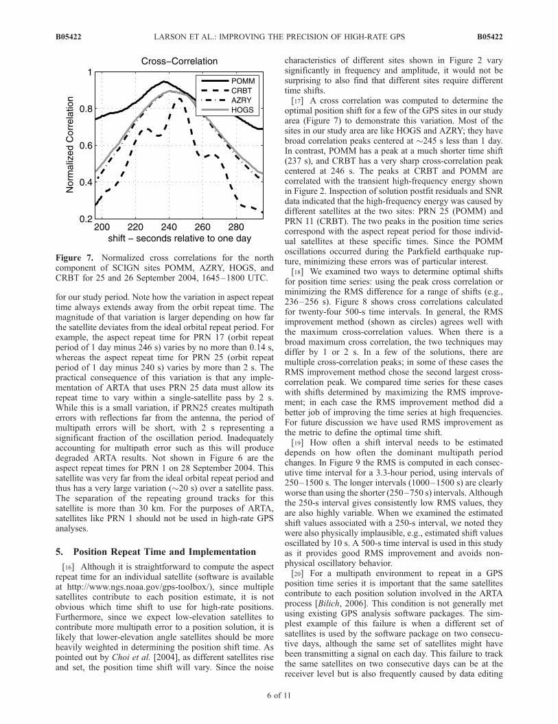
characteristics of different sites shown in Figure 2 varysignificantly in frequency and amplitude, it would not besurprising to also find that different sites require differenttime shifts.[17] A cross correlation was computed to determine the
optimal position shift for a few of the GPS sites in our studyarea (Figure 7) to demonstrate this variation. Most of thesites in our study area are like HOGS and AZRY; they havebroad correlation peaks centered at �245 s less than 1 day.In contrast, POMM has a peak at a much shorter time shift(237 s), and CRBT has a very sharp cross-correlation peakcentered at 246 s. The peaks at CRBT and POMM arecorrelated with the transient high-frequency energy shownin Figure 2. Inspection of solution postfit residuals and SNRdata indicated that the high-frequency energy was caused bydifferent satellites at the two sites: PRN 25 (POMM) andPRN 11 (CRBT). The two peaks in the position time seriescorrespond with the aspect repeat period for those individ-ual satellites at these specific times. Since the POMMoscillations occurred during the Parkfield earthquake rup-ture, minimizing these errors was of particular interest.[18] We examined two ways to determine optimal shifts
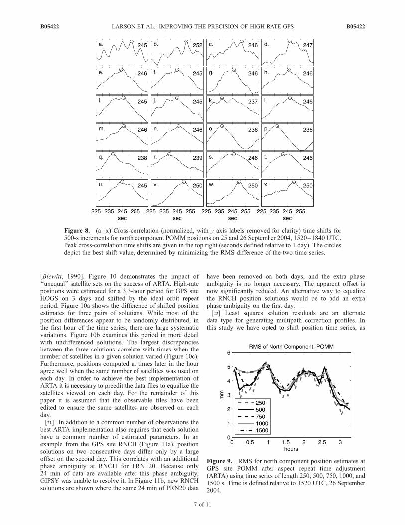
for position time series: using the peak cross correlation orminimizing the RMS difference for a range of shifts (e.g.,236–256 s). Figure 8 shows cross correlations calculatedfor twenty-four 500-s time intervals. In general, the RMSimprovement method (shown as circles) agrees well withthe maximum cross-correlation values. When there is abroad maximum cross correlation, the two techniques maydiffer by 1 or 2 s. In a few of the solutions, there aremultiple cross-correlation peaks; in some of these cases theRMS improvement method chose the second largest cross-correlation peak. We compared time series for these caseswith shifts determined by maximizing the RMS improve-ment; in each case the RMS improvement method did abetter job of improving the time series at high frequencies.For future discussion we have used RMS improvement asthe metric to define the optimal time shift.[19] How often a shift interval needs to be estimated
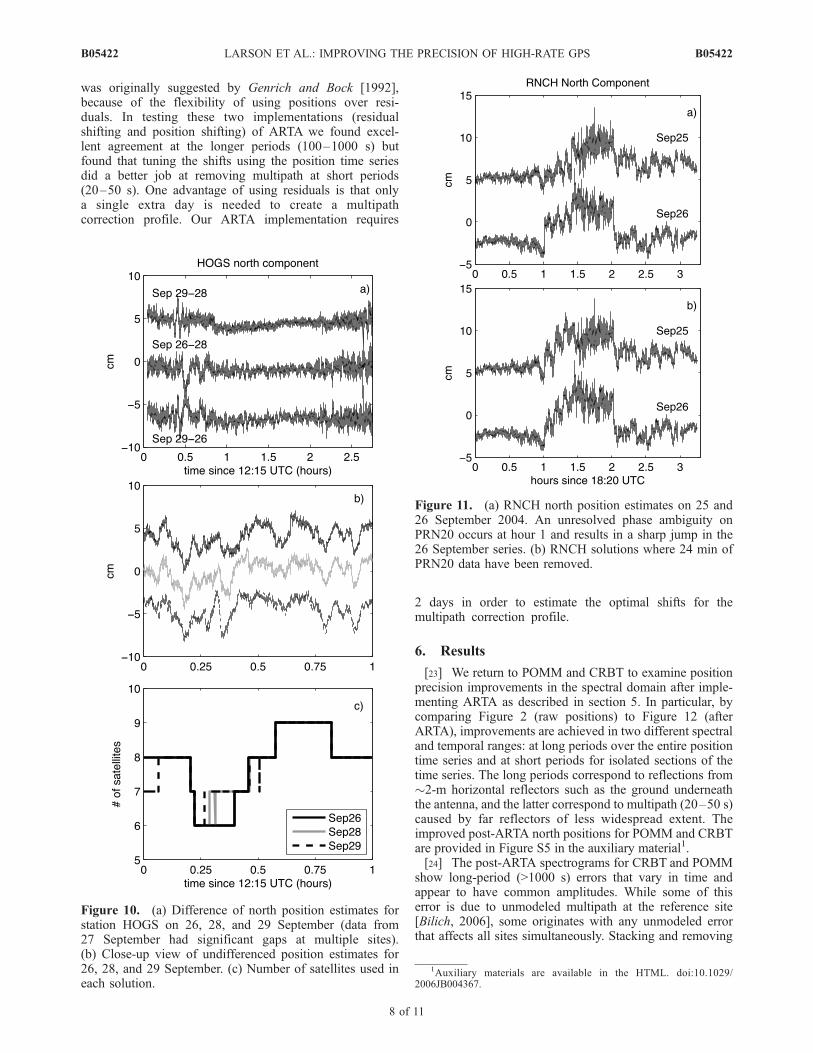
depends on how often the dominant multipath periodchanges. In Figure 9 the RMS is computed in each consec-utive time interval for a 3.3-hour period, using intervals of250–1500 s. The longer intervals (1000–1500 s) are clearlyworse than using the shorter (250–750 s) intervals. Althoughthe 250-s interval gives consistently low RMS values, theyare also highly variable. When we examined the estimatedshift values associated with a 250-s interval, we noted theywere also physically implausible, e.g., estimated shift valuesoscillated by 10 s. A 500-s time interval is used in this studyas it provides good RMS improvement and avoids non-physical oscillatory behavior.[20] For a multipath environment to repeat in a GPS
position time series it is important that the same satellitescontribute to each position solution involved in the ARTAprocess [Bilich, 2006]. This condition is not generally metusing existing GPS analysis software packages. The sim-plest example of this failure is when a different set ofsatellites is used by the software package on two consecu-tive days, although the same set of satellites might havebeen transmitting a signal on each day. This failure to trackthe same satellites on two consecutive days can be at thereceiver level but is also frequently caused by data editing
Figure 7. Normalized cross correlations for the northcomponent of SCIGN sites POMM, AZRY, HOGS, andCRBT for 25 and 26 September 2004, 1645–1800 UTC.
B05422 LARSON ET AL.: IMPROVING THE PRECISION OF HIGH-RATE GPS
6 of 11
B05422
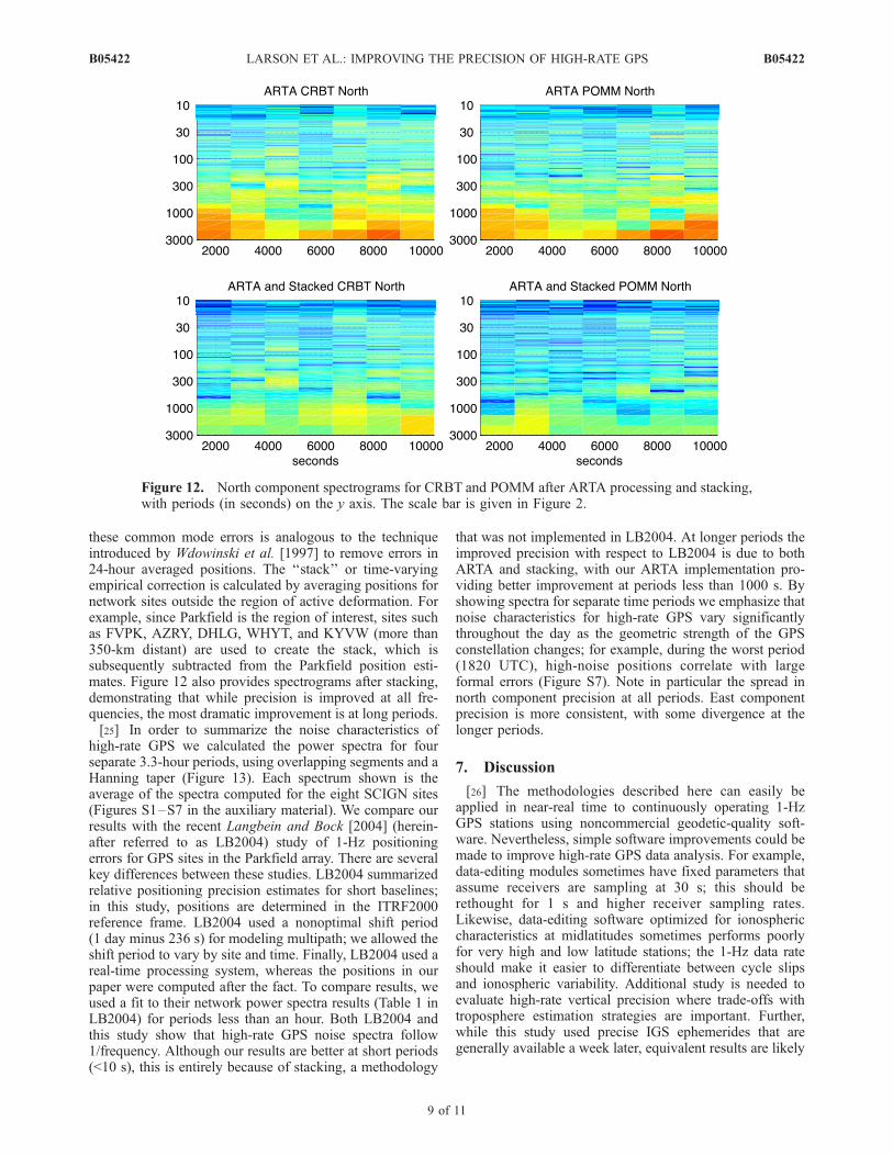
[Blewitt, 1990]. Figure 10 demonstrates the impact of‘‘unequal’’ satellite sets on the success of ARTA. High-ratepositions were estimated for a 3.3-hour period for GPS siteHOGS on 3 days and shifted by the ideal orbit repeatperiod. Figure 10a shows the difference of shifted positionestimates for three pairs of solutions. While most of theposition differences appear to be randomly distributed, inthe first hour of the time series, there are large systematicvariations. Figure 10b examines this period in more detailwith undifferenced solutions. The largest discrepanciesbetween the three solutions correlate with times when thenumber of satellites in a given solution varied (Figure 10c).Furthermore, positions computed at times later in the houragree well when the same number of satellites was used oneach day. In order to achieve the best implementation ofARTA it is necessary to preedit the data files to equalize thesatellites viewed on each day. For the remainder of thispaper it is assumed that the observable files have beenedited to ensure the same satellites are observed on eachday.[21] In addition to a common number of observations the
best ARTA implementation also requires that each solutionhave a common number of estimated parameters. In anexample from the GPS site RNCH (Figure 11a), positionsolutions on two consecutive days differ only by a largeoffset on the second day. This correlates with an additionalphase ambiguity at RNCH for PRN 20. Because only24 min of data are available after this phase ambiguity,GIPSY was unable to resolve it. In Figure 11b, new RNCHsolutions are shown where the same 24 min of PRN20 data
have been removed on both days, and the extra phaseambiguity is no longer necessary. The apparent offset isnow significantly reduced. An alternative way to equalizethe RNCH position solutions would be to add an extraphase ambiguity on the first day.[22] Least squares solution residuals are an alternate
data type for generating multipath correction profiles. Inthis study we have opted to shift position time series, as
Figure 9. RMS for north component position estimates atGPS site POMM after aspect repeat time adjustment(ARTA) using time series of length 250, 500, 750, 1000, and1500 s. Time is defined relative to 1520 UTC, 26 September2004.
Figure 8. (a–x) Cross-correlation (normalized, with y axis labels removed for clarity) time shifts for500-s increments for north component POMM positions on 25 and 26 September 2004, 1520–1840 UTC.Peak cross-correlation time shifts are given in the top right (seconds defined relative to 1 day). The circlesdepict the best shift value, determined by minimizing the RMS difference of the two time series.
B05422 LARSON ET AL.: IMPROVING THE PRECISION OF HIGH-RATE GPS
7 of 11
B05422
was originally suggested by Genrich and Bock [1992],because of the flexibility of using positions over resi-duals. In testing these two implementations (residualshifting and position shifting) of ARTA we found excel-lent agreement at the longer periods (100–1000 s) butfound that tuning the shifts using the position time seriesdid a better job at removing multipath at short periods(20–50 s). One advantage of using residuals is that onlya single extra day is needed to create a multipathcorrection profile. Our ARTA implementation requires
2 days in order to estimate the optimal shifts for themultipath correction profile.
6. Results
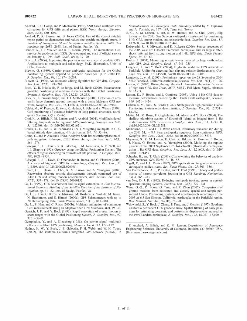
[23] We return to POMM and CRBT to examine positionprecision improvements in the spectral domain after imple-menting ARTA as described in section 5. In particular, bycomparing Figure 2 (raw positions) to Figure 12 (afterARTA), improvements are achieved in two different spectraland temporal ranges: at long periods over the entire positiontime series and at short periods for isolated sections of thetime series. The long periods correspond to reflections from�2-m horizontal reflectors such as the ground underneaththe antenna, and the latter correspond to multipath (20–50 s)caused by far reflectors of less widespread extent. Theimproved post-ARTA north positions for POMM and CRBTare provided in Figure S5 in the auxiliary material1.[24] The post-ARTA spectrograms for CRBT and POMM
show long-period (>1000 s) errors that vary in time andappear to have common amplitudes. While some of thiserror is due to unmodeled multipath at the reference site[Bilich, 2006], some originates with any unmodeled errorthat affects all sites simultaneously. Stacking and removing
Figure 10. (a) Difference of north position estimates forstation HOGS on 26, 28, and 29 September (data from27 September had significant gaps at multiple sites).(b) Close-up view of undifferenced position estimates for26, 28, and 29 September. (c) Number of satellites used ineach solution.
Figure 11. (a) RNCH north position estimates on 25 and26 September 2004. An unresolved phase ambiguity onPRN20 occurs at hour 1 and results in a sharp jump in the26 September series. (b) RNCH solutions where 24 min ofPRN20 data have been removed.
1Auxiliary materials are available in the HTML. doi:10.1029/2006JB004367.
B05422 LARSON ET AL.: IMPROVING THE PRECISION OF HIGH-RATE GPS
8 of 11
B05422
these common mode errors is analogous to the techniqueintroduced by Wdowinski et al. [1997] to remove errors in24-hour averaged positions. The ‘‘stack’’ or time-varyingempirical correction is calculated by averaging positions fornetwork sites outside the region of active deformation. Forexample, since Parkfield is the region of interest, sites suchas FVPK, AZRY, DHLG, WHYT, and KYVW (more than350-km distant) are used to create the stack, which issubsequently subtracted from the Parkfield position esti-mates. Figure 12 also provides spectrograms after stacking,demonstrating that while precision is improved at all fre-quencies, the most dramatic improvement is at long periods.[25] In order to summarize the noise characteristics of
high-rate GPS we calculated the power spectra for fourseparate 3.3-hour periods, using overlapping segments and aHanning taper (Figure 13). Each spectrum shown is theaverage of the spectra computed for the eight SCIGN sites(Figures S1–S7 in the auxiliary material). We compare ourresults with the recent Langbein and Bock [2004] (herein-after referred to as LB2004) study of 1-Hz positioningerrors for GPS sites in the Parkfield array. There are severalkey differences between these studies. LB2004 summarizedrelative positioning precision estimates for short baselines;in this study, positions are determined in the ITRF2000reference frame. LB2004 used a nonoptimal shift period(1 day minus 236 s) for modeling multipath; we allowed theshift period to vary by site and time. Finally, LB2004 used areal-time processing system, whereas the positions in ourpaper were computed after the fact. To compare results, weused a fit to their network power spectra results (Table 1 inLB2004) for periods less than an hour. Both LB2004 andthis study show that high-rate GPS noise spectra follow1/frequency. Although our results are better at short periods(<10 s), this is entirely because of stacking, a methodology
that was not implemented in LB2004. At longer periods theimproved precision with respect to LB2004 is due to bothARTA and stacking, with our ARTA implementation pro-viding better improvement at periods less than 1000 s. Byshowing spectra for separate time periods we emphasize thatnoise characteristics for high-rate GPS vary significantlythroughout the day as the geometric strength of the GPSconstellation changes; for example, during the worst period(1820 UTC), high-noise positions correlate with largeformal errors (Figure S7). Note in particular the spread innorth component precision at all periods. East componentprecision is more consistent, with some divergence at thelonger periods.
7. Discussion
[26] The methodologies described here can easily beapplied in near-real time to continuously operating 1-HzGPS stations using noncommercial geodetic-quality soft-ware. Nevertheless, simple software improvements could bemade to improve high-rate GPS data analysis. For example,data-editing modules sometimes have fixed parameters thatassume receivers are sampling at 30 s; this should berethought for 1 s and higher receiver sampling rates.Likewise, data-editing software optimized for ionosphericcharacteristics at midlatitudes sometimes performs poorlyfor very high and low latitude stations; the 1-Hz data rateshould make it easier to differentiate between cycle slipsand ionospheric variability. Additional study is needed toevaluate high-rate vertical precision where trade-offs withtroposphere estimation strategies are important. Further,while this study used precise IGS ephemerides that aregenerally available a week later, equivalent results are likely
Figure 12. North component spectrograms for CRBT and POMM after ARTA processing and stacking,with periods (in seconds) on the y axis. The scale bar is given in Figure 2.
B05422 LARSON ET AL.: IMPROVING THE PRECISION OF HIGH-RATE GPS
9 of 11
B05422

to be obtained using the very high quality rapid IGSephemerides available within 24 hours.[27] It is more difficult to assess how easily these meth-
ods can be implemented in real time. While ultrarapid(http://www.gfz-potsdam.de/pb1/igsacc/igsacc_ultra.html)IGS ephemerides are much more accurate than broadcastephemerides, because they are based on prediction ratherthan postanalysis, they will always be less accurate thanprecise or rapid ephemerides. With predicted orbits, esti-mated positions from smaller aperture networks like Park-field will always be more accurate than for the largernetworks shown here.[28] As disk storage and memory have become less
expensive, many continuous GPS receivers are being con-verted to operate at 1 Hz. Nevertheless, there will always bedata of interest to geophysicists that were collected at lowersampling rates, e.g., 30 s. While these GPS data are notuseful for seismic applications, they are of significantinterest for monitoring volcanic activity and postseismicdeformation. For future research we plan to investigate howto reduce multipath errors in GPS time series at periodsappropriate to these data sets (minutes to hours).
8. Conclusions
[29] The theory and sample results presented here illus-trate the key factors in correcting site-specific multipath forhigh-rate GPS applications. The primary limitations are thelevel of repeatability of the GPS satellite orbits and thefrequency of the multipath oscillations. These two factorscouple together in that successful reduction of short-periodmultipath effects is sensitive to the degree of repetition ofthe GPS satellite ground track. In order to accuratelyestimate dynamic displacements at seismic frequencies with
GPS, multipath errors with periods of 20–50 s caused by farmultipath reflectors must be reduced.[30] Recognizing that satellites do not contribute equally to
position estimates and have disparate levels of multipath, anew implementation of ARTA has been developed. Optimalshift periods are estimated from the position time series foreach GPS site and are allowed to vary in time to accommo-date changes in the multipath environment. If available,stations outside the area of geophysical interest can be usedto model common mode errors. Using 12 hours of 1-Hz GPSdata from southern California, the standard deviation of eastand north component positions were improved from 6.2 to2.6 mm and 8.2 to 3.0 mm, respectively.
[31] Acknowledgments. This research was sponsored by NSF grantson multipath (EAR-0003943) and high-rate GPS (EAR-0337206), a NSFgraduate student research fellowship (A.B.), a CU Faculty Fellowship(K.M.L.), and a USGS grant (05HQGR0015). Infrastructure support forGPS research in the United States is provided by UNAVCO, JPL, NASA,IGS, and SOPAC. All SCIGN (W.M. Keck Foundation, NASA, NSF,USGS, and SCEC) data are in the public domain. GIPSY was developedand licensed by JPL. Mark Simons and Geoff Blewitt encouraged us toestimate optimal shifts from the time series themselves. Duncan Agnewprovided useful feedback on an earlier draft of the manuscript and wrote theasprep code that is available at the GPS Tool Box (available at http://www.ngs.noaa.gov/gps-toolbox/). Orbit repeat period software is alsoavailable at that Web site. We thank Kyuhong Choi, Stephen Esterhuizen,James Gidney, John Berg, George Rosborough, and Michael Scharber. Wealso thank an anonymous reviewer and Jan Kouba for helpful reviewcomments that substantially improved this manuscript.
ReferencesAgnew, D. C. (1992), The time-domain behavior of power-law noises,Geophys. Res. Lett., 19(4), 333–336.
Agnew, D. C., and K. M. Larson (2007), Finding the repeat times of theGPS constellation, GPS Solutions, 11(1), 71–76.
Altamimi, Z., P. Sillard, and C. Boucher (2002), ITRF2000: A new releaseof the International Terrestrial Reference Frame for earth science applica-tions, J. Geophys. Res., 107(B10), 2214, doi:10.1029/2001JB000561.
Figure 13. (a) East and (b) north component average-power spectra for four 3.3-hour periods comparedwith Langbein and Bock’s [2004] estimates (straight line). Network data from 1220 UTC are notpresented because of significant data outages.
B05422 LARSON ET AL.: IMPROVING THE PRECISION OF HIGH-RATE GPS
10 of 11
B05422
Axelrad, P., C. Comp, and P. MacDoran (1996), SNR based multipath errorcorrection for GPS differential phase, IEEE Trans. Aerosp. Electron.Syst., 32(2), 650–660.
Axelrad, P., K. Larson, and B. Jones (2005), Use of the correct satelliterepeat period to characterize and reduce site-specific multipath errors, inInstitute of Navigation Global Navigation Satellite Systems 2005 Pro-ceedings, pp. 2638–2648, Inst. of Navig., Fairfax, Va.
Beutler, G., I. I. Mueller, and R. E. Neilan (1994), The international GPSservice for geodynamics (IGS): Development and start of official serviceon January 1, 1994, Bull. Geod., 68(1), 39–70.
Bilich, A. (2006), Improving the precision and accuracy of geodetic GPS:Applications to multipath and seismology, Ph.D. dissertation, Univ. ofColo., Boulder.
Blewitt, G. (1989), Carrier phase ambiguity resolution for the GlobalPositioning System applied to geodetic baselines up to 2000 km,J. Geophys. Res., 94, 10,187–10,203.
Blewitt, G. (1990), An automatic editing algorithm for GPS data, Geophys.Res. Lett., 17(3), 199–202.
Bock, Y., R. Nikolaidis, P. de Jonge, and M. Bevis (2000), Instantaneousgeodetic positioning at medium distances with the Global PositioningSystem, J. Geophys. Res., 105, 28,223–28,253.
Bock, Y., L. Prawirodirdjo, and T. I. Melbourne (2004), Detection of arbi-trarily large dynamic ground motions with a dense high-rate GPS net-work, Geophys. Res. Lett., 31, L06604, doi:10.1029/2003GL019150.
Celebi, M., W. Prescott, R. Stein, K. Hudnut, J. Behr, and S. Wilson (1999),GPS monitoring of dynamic behavior of long-period structures, Earth-quake Spectra, 15(1), 55–66.
Choi, K., A. Bilich, K. M. Larson, and P. Axelrad (2004), Modified siderealfiltering: Implications for high-rate GPS positioning, Geophys. Res. Lett.,31, L22608, doi:10.1029/2004GL021621.
Cohen, C. E., and B. W. Parkinson (1991), Mitigating multipath in GPS-based attitude determination, Adv. Astronaut. Sci., 74, 53–68.
Comp, C., and P. Axelrad (1998), Adaptive SNR-based carrier phase multi-path mitigation technique, IEEE Trans. Aerosp. Electron. Syst., 34(1),264–276.
Elosegui, P., J. L. Davis, R. K. Jaldehag, J. M. Johansson, A. E. Niell, andI. I. Shapiro (1995), Geodesy using the Global Positioning System: Theeffects of signal scattering on estimates of site position, J. Geophys. Res.,100, 9921–9934.
Elosegui, P., J. L. Davis, D. Oberlander, R. Baena, and G. Ekstrom (2006),Accuracy of high-rate GPS for seismology, Geophys. Res. Lett., 33,L11308, doi:10.1029/2006GL026065.
Emore, G., J. Haase, K. Choi, K. M. Larson, and A. Yamagiwa (2007),Recovering absolute seismic displacements through combined use of1-Hz GPS and strong motion accelerometers, Bull. Seismol. Soc. Am.,97(2), 357–378, doi:10.1785/0120060153.
Ge, L. (1999), GPS seismometer and its signal extraction, in 12th Interna-tional Technical Meeting of the Satellite Division of the Institute of Na-vigation, pp. 41–52, Inst. of Navig., Fairfax, Va.
Ge, L., S. Han, C. Rizos, Y. Ishikawa, M. Hoshiba, Y. Yoshida, M. Izawa,N. Hashimoto, and S. Himori (2000a), GPS Seismometers with up to20 Hz Sampling Rate, Earth Planets Space, 52(10), 881–884.
Ge, L., S. Han, and C. Rizos (2000b), Multipath mitigation of continuousGPS measurements using an adaptive filter, GPS Solutions, 4(2), 19–30.
Genrich, J. F., and Y. Bock (1992), Rapid resolution of crustal motion atshort ranges with the Global Positioning System, J. Geophys. Res., 97,3261–3269.
Georgiadou, Y., and A. Kleusberg (1988), On carrier signal multipatheffects in relative GPS positioning, Manuscr. Geod., 13, 172–179.
Hudnut, K. W., Y. Bock, J. E. Galetzka, F. H. Webb, and W. H. Young(2002), The southern California integrated GPS network (SCIGN), in
Seismotectonics in Convergent Plate Boundary, edited by Y. Fujinawaand A. Yoshida, pp. 167–189, Terra Sci., Tokyo.
Ji, C., K. M. Larson, Y. Tan, K. W. Hudnut, and K. Choi (2004), Sliphistory of the 2003 San Simeon earthquake constrained by combining1-Hz GPS, strong motion, and teleseismic data, Geophys. Res. Lett., 31,L17608, doi:10.1029/2004GL020448.
Kobayashi, R., S. Miyazaki, and K. Koketsu (2006), Source processes ofthe 2005 west off Fukuoka Prefecture earthquake and its largest after-shock inferred from strong motion and 1-Hz GPS data, Earth PlanetsSpace, 58, 57–62.
Kouba, J. (2003), Measuring seismic waves induced by large earthquakeswith GPS, Stud. Geophys. Geod., 47, 741–755.
Langbein, J., and Y. Bock (2004), High-rate real-time GPS network atParkfield: Utility for detecting fault slip and seismic displacements, Geo-phys. Res. Lett., 31, L15S20, doi:10.1029/2003GL019408.
Langbein, J., et al. (2005), Preliminary report on the 28 September 2004M6.0 Parkfield, California earthquake, Seismol. Res. Lett., 76(1), 10–26.
Larson, K. (2005), Rising through the stack: Assessing the scientific valueof high-rate GPS, Eos Trans. AGU, 86(52), Fall Meet. Suppl., AbstractG13A-03.
Larson, K., P. Bodin, and J. Gomberg (2003), Using 1-Hz GPS data tomeasure deformations caused by the Denali Fault earthquake, Science,300, 1421–1424.
Lichten, S. M., and J. S. Border (1987), Strategies for high-precision GlobalPositioning System orbit determination, J. Geophys. Res., 92, 12,751–12,762.
Mattia, M., M. Rossi, F. Guglielmino, M. Aloisi, and Y. Bock (2004), Theshallow plumbing system of Stromboli Island as imaged from 1 Hzinstantaneous GPS positions, Geophys. Res. Lett., 31, L24610,doi:10.1029/2004GL021281.
Melbourne, T. I., and F. H. Webb (2002), Precursory transient slip duringthe 2001 Mw = 8.4 Peru earthquake sequence from continuous GPS,Geophys. Res. Lett., 29(21), 2032, doi:10.1029/2002GL015533.
Miyazaki, S., K. M. Larson, K. Choi, K. Hikima, K. Koketsu, P. Bodin,J. Haase, G. Emore, and A. Yamagiwa (2004), Modeling the ruptureprocess of the 2003 September 25 Tokachi-Oki (Hokkaido) earthquakeusing 1-Hz GPS data, Geophys. Res. Lett., 31, L21603, doi:10.1029/2004GL021457.
Schupler, B., and T. Clark (2001), Characterizing the behavior of geodeticGPS antennas, GPS World, 12, 48–55.
Segall, P., and J. L. Davis (1997), GPS applications for geodynamics andearthquake studies, Annu. Rev. Earth Planet. Sci., 25, 301–336.
Van Dierendonck, A. J., P. Fenton, and T. Ford (1993), Theory and perfor-mance of narrow correlator Spacing in a GPS Receiver, Navigation,39(3), 265–283.
van Nee, D. J. R. (1992), Reducing multipath tracking errors in spread-spectrum ranging systems, Electron. Lett., 28(8), 729–731.
Wang, G.-Q., D. Boore, G. Tang, and X. Zhou (2007), Comparisons ofground motions from colocated and closely spaced one-sample-per-second Global Positioning System and accelerograph recordings of the2003 M 6.5 San Simeon, California, earthquake in the Parkfield region,Bull. Seismol. Soc. Am., 97(1B), 76–90.
Wdowinski, S., Y. Bock, J. Zhang, P. Fang, and J. Genrich (1997), SouthernCalifornia permanent GPS geodetic array: Spatial filtering of daily posi-tions for estimating coseismic and postseismic displacements induced bythe 1992 Landers earthquake, J. Geophys. Res., 102, 18,057–18,070.
�����������������������P. Axelrad, A. Bilich, and K. M. Larson, Department of Aerospace
Engineering Sciences, University of Colorado, Boulder, CO 80309, USA.([email protected])
B05422 LARSON ET AL.: IMPROVING THE PRECISION OF HIGH-RATE GPS
11 of 11
B05422