in - maryland historical trust · _district _public ~ccu pied xbuilding(s) ... exterior design the...
TRANSCRIPT

Mexico Farm AL-111-A-154 ca. 1852
Mexico Farm was built around 1852 on a highly productive farm on the fertile Potomac River flood plain south of Cumberland. An early owner of the farm was a slave owner who grew wheat, indian corn, oats, hay, and tobacco in great quantities. The farm was sold in 1822 to a business man from Baltimore County who later sold two-thirds of it to two merchants from Baltimore. Together the three operated the farm for profits and may have been involved in milling the grain. In 1852 a third of the farm was bought by Margaret S. Duncan of Baltimore County who built the large brick house. The Long family owned the farm from 1866 until 1974. At one time during that period it was a tavern serving traffic on the nearby C & 0 Canal and a public highway which forded the Potomac River on the farm. Early in the 1920 1 s the Army Air Corps established an emergency landing field on the Long farm which consisted of barracks of five men, gasoline storage facilities, and two radio transmission towers. When private citizens opened another landing strip on the adjacent Johnson farm the army field was abandoned.
The brick house is one of the finest example of the Pennsylvanian Vernacular sytle house in Allegany County. It is a 11 L11 shaped, two and one-half stories tall, five bays wide structure with a gabled ribbed tin roof and flush end chimneys. The main facade is laid in flemish bond brick with gauged flat brick arches over the first floor windows and doors. The brick cornice is unique for this area with both dentils and mouse-tooth designs. The interior of the building contains or1ginal woodwork and columned wooden fireplaces and built in cupboards also in original condition.

MARYLAND HISTORICAL TRUST
AL- 111-A-154 MAGI NO. 0107725504
INVENTORY FORM FOR STATE HISTORIC SITES SURVEY
HISTORIC
Mexico Farm ANO/OR COMMON
flLOCATION STREET & NUMBER
Mexico Farms Road CITY. TOWN
Cumberland .Jl VICINITY OF
STATE Maryland
DcLAsSIFICATION
CATEGORY OWNERSHIP STATUS _DISTRICT _PUBLIC ~CCU PIED
XBUILDING(S) >i_PRIVATE _UNOCCUPIED
_STRUCTURE _BOTH _WORK IN PROGRESS
_SITE PUBLIC ACQUISITION ACCESSIBLE _OBJECT _IN PROCESS _YES RESTRICTED
_BEING CONSIDERED ~YES UNRESTRICTED
_NO
DOWNER OF PROPERTY NAME
Bi 11 L. Smith STREET & NUMBER
Mexico Farms CITY. TOWN
Cumberland _ v1c1N1TY oF
llLOCATION OF LEGAL DESCRIPTION COURTHOUSE. REGISTRY OF DEEDS. ETC Allegany County courthouse STREET & NUMBER
30 Washington Street CITY. TOWN
Cumberland. II REPRESENTATION IN EXISTING SURVEYS
TITLE
DATE
Sixth CONGRESSIONAL DISTRICT
COUNTY
Allegany
PRESENT USE
_AGRICULTURE _MUSEUM
_COMMERCIAL __ PARK
_EDUCATIONAL ~PRIVATE RESIDENCE
_ENTERTAINMENT _RELIGIOUS
__ GOVERNMENT _SCIENTIFIC
_INDUSTRIAL _TRANSPORTATION
_MILITARY _OTHER
STATE , zip code Maryl and 21502
Liber #: 484 Folio #: 215
STATE
Maryland 21502
_FEDERAL _STATE _COUNTY _LOCAL
DEPOSITORY FOR
SURVEY RECORDS
CITY. TOWN STATE

B DESCRIPTION
_EXCELLENT
_GOOD
_ FAIR
CONDITION
...XDETERIORATED
_RUINS
_UNEXPOSED
CHECK ONE
.XUNALTERED
_ALTERED
('. - . ' ....... (_ -........._.. .. /. - . ~) :
CHECK ONE
X_oRIGrNAL SITE
_MOVED DATE __ _
DESCRIBE THE PRESENT AND ORIGINAL (IF KNOWN) PHYSICAL APPEARANCE
Mexico Farm is located north of Mexico Farms Road approximately four miles south of Cumberland.
The building consists of a two and one-half story, five bays wide 11 L11
shaped structure. Wall construction is of brick, laid in Flemish bond on the principal, or southwestern facade, and in american common bond in a variation of five to one elsewhere. It rests on a low foundation of coursed rubble sheathed in cement with a beveled cement water table. The gable flank roof of the main block and the gabled roof of the wing are covered with ribbed tin. Eaves consist of a boxed cornice with a short sloped soffit, and a brick frieze decorated with bricks laid in a "mouse toothM design and brick dentils. Three brick chimneys are located flush end, a larger brick chimney with a corbeled cap is in the center of the win .
The main entrance located in the center of the southwestern facade includes double doors of three panels each, paneled jambs, and an original four light transom. Three entrances to additions now removed have been bricked shut. Three entrances, one on the second floor, lead to a porch on the southeast of the wing. Original pegged six over six light windows have replaced cement lugsills on the main block and wooden lugsills on the wing. Wooden shutters are on the southwestern windows. Two casement windows surround each of the flush end chimneys. Gauged flat brick arches are over the windows and entrance of the southwestern first floor, other windows and entrances have flat brick arches. A two tiered shed roofed porch is on the southeastern flank of the wing. A gabled "summer kitchen" addition abutting the wing on the northeast has been removed. Another removed addition was on the inside corner of the 11 L11 shaped building. A log out building is on the property.
CONTINUE ON SEPARATE SHEET IF NECESSARY

Ill SIGNIFICANCE AL-III~A-15/
PERIOD AREAS OF SIGNIFICANCE -- CHECK AND JUSTIFY BELOW
_PREHISTORIC --ARCHEULUGY-PREHISTORIC _COMMUNITY PLANNING _LANDSCAPE ARCHITECTURE _RELIGION
- 1400- 1499 --ARCHEOLOGY -HISTORIC _CONSERVATION _LAW _SCI ENCE
-1500-1599 --AGRICULTUR~ _ECONOMICS _LITERATURE _SCULPTURE
- 1600- 1699 --ARCHITECTURE _EDUCATION _MILITARY _SOCIAUHUMANITARIAN
- 1700-1799 __ART _ENGINEERING _MUSIC _THEATER
- 1800-1899 _COMMERCE -EXPLORATION/SETTLEMENT _PHILOSOPHY _TRANSPORTATION
- 1900- _COMMUNICATIONS _INDUSTRY _POLITICS/GOVERNMENT _OTHER ISPECIFYI
_INVENTION
SPECIFIC DATES BUILDER/ ARCHITECT
STATEMENT OF SIGNIFICANCE
Mexico Farm, is one of the finest example of the Pennsylvanian Vernacular style house in Allegany County. In both interior and exterior design the building conforms to the general pattern of the style and has been subject to little alteration.
The land on which the house was built was purchased in 1812 and 1813 by John Burbridge. (1) Burbridge became heavily indebted and his property was sold at public sale in 1822. (2) Lists of goods and property sold present a picture of thriving agriculture on the fertile Potomac River flood plain south of Cumberland, Included were four slaves, twelve horses, twenty stacks of wheat, fifteen hundred bushels of indian corn, three hundred bushels of oats, five stacks of hay, and an entire crop of tobacco, 11 new and old 11
• (3)
The highest bidder at the sale was Edward Day of Baltimore County who paid more than fifteen thousand dollars for Burbridges farm and produce. ( 4) The tracts conveyed to Day were 11 Cresaps Kindness 11
, 11 Cow Pasture 11 ,"Conclusion 11
, and 11 Dispute 11 which together with 11 vacant lands 11 formed a twelve hundred and ninety-two acre farm known as 11 Mexico 11
• (5) It is apparent that Burbridge applied this name to honor Mexico's rise to independence which was then a cause with much popular support in America. (6) Day's interest in the farm and the high price he paid for it may have been the result of the proposed extension of slack water navigation of the Potomac River to Cumberland. This scheme caused land speculation in Cumberland and along the river but was never carried out. (7)
Edward Day was a wealthy man who in 1813 built a stone church and rectory 11 at his own expense 11 at Kingsville in Baltimore County. (8) In 1824 he sold an undivided twu-thirds of 11 Mexico 11 to Alexander MacDonald and Nicholas C. Ridgely of the city of Baltimore. (9) Trading under the firm of MacDonald and Ridgely they operated a general store in Baltimore and were obviously involved with Day in grain and milling enterprises. (10) The two Baltimoreans also owned a house on lot thirtyseven on Mechanic Street in Cumberland. (11)
(cont.)
CONTINUE ON SEPARATE SHEET IF NECESSARY
IJMAJOR BIBLIOGRAPHICAL REFERENCES John M. Blum, et al. The National Experience Vol. L (New York Harcourt, Brance & World 1968) Lowdermilk, Will H. History of Cumberland, Baltimore: Regional Publishing Co., 1971 Wright Milton, C. Our Harford Heritage (published by author) Scharf, J:T. Histo~altimore Cit~and County (Philadelphia: Louis H. Everts, 1881) W~~~Tf~£r1:sts~e'SE~1§1•¥fl{is~;ijkfo Maryland (Ann~po~ is, Md. : Fishergate
II!JGEOGRAPHICAL DATA ! Qw&ll&RlA~ ,9 1918)
ACREAGE OF NOMINATED PROPERTY 3. 75 Acres
VERBAL BOUNDARY DESCRIPTION
LIST ALL STATES AND COUNTIES FOR PROPERTIES OVERLAPPING STATE OR COUNTY BOUNDARIES
STATE COUNTY
STATE COUNTY
IDFORM PREPARED BY NAME I TITLE
David A. Dorsey, Historic Sites Coordinator ORGANIZATION DATE
Allegany County Historic Sites Survey July 24, 1979 STREET & NUMBER TELEPHONE
County Office Building, 3 Pershing Street (301) 777-5944 CITY OR TOWN STATE
Cumberland, Maryland 21502
The Maryland Historic Sites Inventory was officially created by an Act of the Maryland Legislature, to be found in the Annotated Code of Maryland, Article 41, Section 181 KA, 1974 Supplement.
The Survey and Inventory are being prepared for information and record purposes only and do not constitute any infringement of individual property rights.
RETURN TO: Maryland Historical Trust The Shaw House, 21 State Circle Annapolis, Maryland 21401 ( 301) 267-1438
PS· 1108

Al-111-A-154 Mexico Farm
In 1852 a trustee for MacDonald's estate sold his one third share of the farm and its profits to Margaret S. Duncan of Baltimore County.(12} It was soon after this date that the brick farmhouse was built. The fact that Duncan sold the same sized property fourteen years later at more than double her purchase price is indicative of a major improvement. (13} The deed by which she 'Conveyed her portion of the farm to Henry F. Weber mentions a brick house. (14} Less than a year later Weber sold the property to William Long. This deed refered to the brick house and right of way for a canal ferry road to the C & 0 Canal and for a public highway fording the Potomac which led to the town of Frankfort (Fort Ashby, W Va.), (15) An equity case of 1900 described a "two story brick dwelling in good repair." (16)
The Long family owned the farmhouse from 1866 until 1974. (17} Early during this period the building was used as a tavern along the public road.(18) In 1920 or 1921 the Army Air Corps establised an emergency landing filed on the flat fields bordering the Potomac River. Barracks for five men, gasoline storage facilities, and radio transmission towers were erected on the Long farm. (19) Among the planes to use the landing strip were World War One Martin Bombers and fighter planes. Eventually the airport, under civilian control, was moved to the adjacent farm of Jerome Johnson and the Anny facilities were removed. (20)
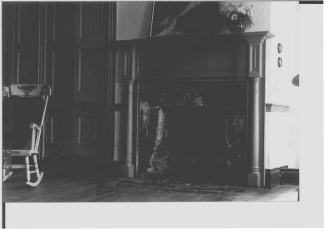
The farmhouse was built with many features characteristic of the Pennsylvanian Vernacular sytle and others that are somewhat unique. The 11 L11 shaped building is two and one-half stories tall and five bays wide with a gabled ribbed tin roof and flushed end chimneys. The main facade is finished in flemish bond with gauged flatbrick arches. over first floor windows and doors. An interesting feature is the brick cornice with dentils and mouse- tooth designs similar to buildings constructed early during the nineteenth century in Westminster, Maryland. (21) A two tiered shed roofed side porch and the pegged six over six light sash windows appear to be original.
The interior is arranged with a centra 1 ha 1 h1ay with an open we 11 stairway with one large room on either side. Original woodwork is largely intact. This includes high baseboards, chair rails, synmetrical moulding with bullseye blocks on doors and windows, and sawed reeding on the string of the central stairway. Built in cupboards and columned wooden fireplaces with moulding are in original condition.
Th~ story of Mexico Farm is a varied o~which illustrates the gradual ~hange in the charact~r of Allegany County. Early in the nineteenth century it was a farmstead which later became the source of profits for enterprising merchants of Baltimore who tapped Western Maryland's agrarian bounty. The fa~house, built during the early l850's, was an early example of a style which g~ined a~ceptance in this area later than it did in the rest of Maryland At one time during the 104 years it was owned by the Long family the building was a ~avern serving traffic of the nearby C&O Canal and a public highway. Early in the 1920's it was the site of the second military airfield established in Maryland. Throughout the years of changing lifestyles and surroundings the

Mexico Farm AL-lll-A-154
Interior Description
The house is arranged with a central hallway with one large room on each side. This hallway originally led to a rear entrance now blocked shut. Walls are finished in plaster with a high baseboard and a chair rail. Windows and doors have symnetrically moulded trim with cornerblocks.
An open well stairway in the central hall is of two and one-half flights and two landings. The closed string is decorated with pendants, fluted trim, and sawed decorative reeding. The original handrail and plain newell are intact. Asteep enclosed one flight stairway with a winder is located behind the flue of the northwesternmost chimney.
Eight wooden fireplaces are parallel to the walls. Those on the first floor have wooden moulding and columns and masonry hearths. Built in dining room cupboards include three sets of double doors of different sizes. Further interior description is included in an enclosed letter.

Mexico Farm cont. AL -JII-4 -1sv
building has remained in virtually original, but slowly poorer, condition.
(1) Allegany County Land Records, Liber G, Folio 127 and Liber G, Folio 76 (2) Ibid, Liber L, Folio 487-488 (3) Ibid, LiberL, Folio 486-487 (4) TDfd, Liber L. Folio 482-489 (5) Ibid, Liber L, Folio 482 (6) John M. Blum, et al, The National Experience, Vol I (New York Harcourt, Brace and
World, 1968), p.200 (7) Will H. Lowdermilk, History of Cumberland (Baltimore: Regional Publishing Co.)p.304 (8) C. Milton Wright, Our Harford Heritage (published by author) p.57 and J.T. Scharf,
History of Baltimore City and County (Philadelphia: Louis H. Everts, 1881} p.921 ·(9) Allegany County Land Records, Li ber M, Folio 403 (10} Telephone interview, Diana Diggs City of Baltimore Corrmittee for Historical and
Architectural Preservation, 9-6-79 (lll Allegany County Assessments, 1825-1832 p.351 (12 Allegany County Land Records, Liber 11, Folio 246 (13 Ibid, Liber 23, Folio 620 (14} Ibid (15) lliTd, Liber 25, Folio 329 (16) AlTegany County Equity,#5046 (17) Allegany County Land Records, Liber 469, Folio 771
!18) Interview, Floyd Johnson, Mexico Farms Airport, 8-27-79 19) Ibid, and photographs (see M.H.T. Inventory AL-111-A-153, Mexico Farms Airport) 20) TDfd
(21) Christoper Weeks, The Building of Westminster in Maryland (Annapolis, Maryland: Fishergate Publishing, 1978) p.23

Mexico Farm AL-lll-A-154
TITLE SEARCH
Allegany County Deed: Liber 484, Folio 215 Grantee: Bill L. Smith and Sandra L. Smith Granter: Paul H. Davis and Betty Davis
Allegany County Deed: Liber 473, Folio 90 Grantee: Paul H. Davis and Betty Davis Granter: John A. Miltenberger Jr. & Hilda G. Miltemberger
Allegany County Deed: Liber 464, Folio 771 Grantee: John A. Miltenberger and Hilda G. Miltenberger Granter: Rosella L. Thompson Notes: 162.45 Acres
Orphans Court of Allegany County: Estate #9419 Grantee: Rosella L. Thompson Granter: Michael H. Long (deceased)
Allegany County Deed: Liber 152, Folio 211 Grantee: Michael H. Long Granter: Ida L. Crites and James Crites
Allegany County Deed: Liber 127, Folio 636 Grantee: Ida L. Crites Granter: Michael H. Long Notes 162.45 Acres
Allegany County Deed: Liber 104, Folio 95 Grantee: Michael H. Long Granter: Sallie L. Cunningham and James Cunningham Notes: Estate of Michael M. Long
Allegany County Deed: Liber 89, Folio 50 Grantee: Sallie L. Cunningham Granter: James W. Thomas and D.J. Blackison, trustees Notes: Equity #5046 mentions 525 acre Mexico Farm with
two story brick dwelling in good repair
Allegany County Deed: Liber 25, Folio 329
Date: January 14, 1976
Date: July 12, 1974
Date: March 24, 1974
Date: January 5, 1926
Date: June 9, 1919
Date: December 23, 1908
Date: December 28, 1900 Consideration: $2,535.00
Grantee: William Long Date: December 14, 1866 Granter: Henry F. Weber, et ux Consideration: $12,875.00 Notes: Mentions brickhouse and right-of-way for Canal Ferryroad
and public highway leading to Frankfort (Fort Ashby, W, Va.)

Mexico Farm. cont.
Allegany County Deed: Liber 23, Folio 620 Grantee: Henry F. Weber, et ux Granter: Margaret S. Duncan Notes: 425 acres, mentions brickhouse
Allegany Grantee: Gran tor: Notes:
County Deed: Liber 11, Folio 246 Margaret S. Duncan Robert Lerrmon, trustee Conveyed one-third share of land and profits of Alexander MacDonald, deceased survivor of the firm of MacDonald and Ridgely
Allegany County Deed: Liber M, Folio 403
A L-:rrr-- A -15 y
Date: March 1, 1866 Consideration: $10,625.00
Date: June 25, 1852 Consideration: $4,500.00
Grantee: Alexnader MacDonald and Nicholas C. Ridgely Date: April 30, 1824 Granter: Edward Day Consideration: $8,066.66 Notes: Conveyed undivided two-thirds of negros, premises,
lands, and horses.
Allegany County Deed: Liber L, Folio 482 Grantee: Edward Day (of Baltimore County) Date: October 11, 1822 Granter: John Burbridge Consideration: $12,100.00 Notes: Total 1292 acre tract known as 11 Mexico 11 comprised
of four tracts known as 11 Cresap Kindness 11, "Canel usi on",
11 Dispute 11, and "Cow Pasture, and "Vacant lands". Reconveyed
by Andrew Bruce, esq., Sherriff, October 23, 1822, Liber L, Folio 488 with bills of sale.
Allegany County Deed: Liber G, Folio 127 Grantee: John Burbridge Granter: Heirs of Carlton Belt (of Montgomery County) Notes: Moiety of "Conclusion" and "Dispute"
Allegany County Deed: Liber G, Folio 76 Grantee: John Burbridge Granter: Samuel Ridout Notes: All of 11 Cresap 1 s Kindness"
Date: May 11, 1813 Consideration: $100.00
Date: December 14, 1812 Consideration: $950.00

Mexico Farm
AL - JII -A-15 4 Exterior Dimenslo!JS
3'10'1 317" oo 0"
~(' 'f'o"
'' Oo OJ' 3''" 31l>'1
~ 3''1 - CIC~ 91211 J'//" '!-'!" ..,;- o~ ~ Cl wo o~
~· QI~ ~,..
'.;:~I ~ .,, Vo) ... ~ w' 0 ~ ~
:II:>
" ~1 ... :r ....
() -... 0 ... ~o '° Q.10
~Jlt> ~
~I "' ... "'
(,IJ
~ ::::: ~
b-<.tJ DOGI.
... ... ~ 07 2'10" ~
l//111 fZ" '''Z" Sc.AL£
I 5t ... .,. ,. f' = I Foo-I-

~ .......... ....... ~
-
2'311
AL- Ill.-A-/54
IS# I ntcrior Floor
131
...... _ ... ~
U) .. ---v, ..... .£) -· -.., ~ "" -+ - .... ... ---
5 I 2'10'" -4'Z"
-N .. JV ~
2' I c
D
c ~"' r= f' / 1 5 tt.:rs ; •'
A,,~ -(l'J 0 ... ao ~ ...._
CQ ....
SCALE
I S'luo.re = I Foof

r
\
\ \
HA.~ver A JOMNS.oN
21,;1~5
7/· I / l JOHN A
MILTENBERGER 4(;,9/171 10. 3<DA
P.141
\ ,,
fa34 ,
2n;4s1 '2 l~/+53
:%.SA
P. 14-G? \
\
I~ ( ~ '~~ ~·~~"-'----::Pl
,flOl«J FAllAI /(Ns
I EOWA~O W COLLY '~~ , ) • 151/47~ l(_ ...... ," ............
<0~ A . "-...._ P
) ........... : A. p .......... , 14 __ z
- ./"'\ P. 148 .... ' -~ \. 141 .
/ \
p 5"0-itO
\ \
' \
R1C l--iAROE THOIV'IP£·.:N
464/215 1'3 37A P 14C
-----.-------
. ' ,\
\
DONALD F JOHNSON 3 <04/514
I \ 77.'2<0A . P. 159
P. s. .. i:os:i.o
3 p JEH KI HS
•1 \ ~ 11•n/1+3 P I I '115 A p
I 13e>\ 8 I I I I It p I 3 \ I ?>7 ~
- .'
A \ I C..Eo~c;.E \
'5TA~~ORD \
l 200/530
f wA1..l. A ~E; ,., WAL.I<~~
"'1°1/"181 I I 05A .
p 135
I
I
31.Z7A
P.134
..JAMES E . St ER.MAN

CRESAPTOWN QUADRANGLE WEST VIRGINIA-MARYLAND
7.5 MINUTE SERIES (TOPOGRAPHIC) SE/4 FROSTBURG 15 QUADRANGLE
78°45' - ......,.., ~='--:-r--..,~---~Z""J;-~ --~::r-"'"77""---. 39°37'30"
---"": -- ----- - I
· · -· ta~d•ns roetd
• - Mexico Farm
I
<...
. '


I I


I
"' 1 ) v
v
- I~ I p
k


r
T T


At - I/ I - A . I ~-t; /Z'10..1C'C IA~hf
/1-1Ck1r_; fA1?;115 fa)/)
c v/11 s~ ~tAtV _) ')t-1 vi DA. 1J0/)5(,v
?/'!/7'i 1//JTrtf>1of? f /lfJ!!V6 {W,tt/ ( V'/?&1Atl2)

\ •
' I

Al- /II ~I"-' - /')t/
/\II [' )( I c v l r A .R .1rf
/VI~-' I c~ rA 0Vj .. ; (~ D ( VAi'\ i3 t ~ (. ~ Iv D 'tAv\i/ /..\ bcre~£ ~
g I z/ ict IAJT[Rtc•k
1'4vN\B (-'\Tel-{