index president’s corner - society for historical ... · volume 41: number 4 winter 2008 page 1...
TRANSCRIPT
Volume 41: Number 4 Winter 2008 Page 1
Winter 2008
Alasdair Brooks, D.Phil, Newsletter Editor, OA East, Cambridge, United Kingdom
Index President’s CornerLu Ann De Cunzo
August 2008, when I last wrote to you, feels like years rather than months ago. Economically and politically, it’s been a roller coaster ride of highs and lows that will present challenges and opportuni-ties for SHA in the year to come. Our 2007–2009 strategic planning initiative is more important than ever, as it drives us to focus and set priorities for the next several years. You have elected a strong team to join the SHA and ACUA lead-ership in 2009. Congratulations to in-cumbents Michael Nassaney, Secretary, and Sara Mascia, Treasurer, who were reelected. New Directors joining the SHA Board are Peggy Leshikar-Denton of the Cayman Islands, an underwater archaeologist and current SHA UNES-CO Committee Chair, and Pat Garrow, a southeastern U.S. archaeologist and longtime SHA Conference Committee Chair. Della Scott-Ireton, Filipe de Cas-tro, and Kimberly Eslinger were elected to the ACUA. On the SHA Nominations and Elections Committee, Immediate Past President Doug Scott will be joined by newly elected Members-At-Large Deborah Hull-Walski and Alicia Capo-raso and outgoing Directors Margaret Purser and Nick Honerkamp. I thank all the candidates who agreed to stand for election this year, and look forward to working with this fine group in 2009.
Awards Committee Chair Mary Be-audry has also announced that James Bruseth and Toni Turner will receive the 2009 James Deetz Book Award for From a Watery Grave: The Discovery and Excava-tion of La Salle’s Shipwreck, La Belle (Texas A&M University Press, 2005). Congrat-ulations to Jim and Toni!
Thanks to the Conference Commit-
tee and SHA Headquarters, we now have our conferences scheduled through 2012, with the selection of Baltimore, MD, as the site of the 2012 meetings. Baltimore is an historically rich city with excellent facilities and the region offers wonderful tour and program opportunities for our members. Conference Co-Chairs Susan Langley and Julia Schablitsky are assembling another stellar organizing team for the Society’s 45th annual meeting!
Through the perseverance of the ACUA, the SHA UNESCO and Governmental Af-fairs Committees, and Nellie Longsworth, SHA’s heritage advocacy efforts continue to bear fruit on the international and U.S. national scene. The UNESCO convention on underwater cultural heritage will go into effect on 2 January 2009, with Barba-dos as the final, 20th nation needed to rat-ify. (Read more about it in this Newsletter and on www.sha.org.) SHA and ACUA members have worked tirelessly to educate our colleagues, political leaders, and other stakeholders about the value of this interna-tional agreement to promote a preservation ethic and international cooperation since the first convention assembly in 2001; we will celebrate this accomplishment at the Plenary Session opening the 2009 confer-ence. In October, the U.S. ratified the 1954 Hague Treaty on the Protection of Cultural Property in the Event of Armed Conflict. In 2007, SHA joined 14 other cultural organi-zations in presenting testimony before the Senate Foreign Relations Committee, an-other example of the way that cooperation yields results. Similarly, SHA is joining our partners to encourage the new federal ad-ministration to promote a pres-ervation agenda
Continued on Page 2
President’s Corner .......................................1ACUA Photo Competition Calendar........32008 SHA Election Winners .........................4Minutes of the SHA Board of Directors ......5 SHA Committee News .................................9
Student Subcommittee ...........................9Public Education and Interpretation
Committee ............................................11NPS Prospection Workshop ......................12National Register of Historic Places .........13SHAP Workshop .........................................13Conference and Project Reports ...............14
Commodities of Empire Project ...........14IKUWA3 Conference Report .................15
Call for Papers—TAG U.S.A. 2009 ...........16Current Research ........................................17
Australasia and Antarctica ....................18Canada—Atlantic ....................................18Continental Europe ................................19Great Britain & Ireland .........................20Underwater (Worldwide) ....................21U.S.A—Alaska ........................................25U.S.A.—Gulf States ................................26U.S.A.—Mid-Atlantic .............................28U.S.A.—Midwest .....................................31U.S.A.—Northeast .................................31U.S.A.—Pacific Northwest ....................35U.S.A.—Pacific West ..............................36U.S.A.—Southeast .................................37
SHA 2010—Amelia Island ........................39
Start planning now for SHA 2010!
In sunny (or so the organizing committee promises us) Amelia Island, Florida.
See page 39 for details
Volume 41: Number 4 Winter 2008 Page 2
President’s Corner, Cont’d from Page 1
Published QuarterlySubscription Rate: Individual: Regular ($125), Student ($70), Adjunct ($40),
Friend ($175), Developer ($250), Benefactor ($400), Life ($3,600).Organizational: Institution ($200). All U.S. funds.
Newsletter Editor: Alasdair Brooks, DPhilCopy Editor: Daniel McNaughton.
Special News Editors:Employment Opportunities: Cassandra MichaudCurrent Publications: Charles EwenPublic Education and Interpretation Committee: Brian CraneImages of the Past: Robert Schuyler
Current Research Editors:Africa: Kenneth KellyAsia: Edward Gonzalez-TennantAustralasia: Susan PiddockCanada-Atlantic: Robert FergusonCanada-Ontario: Jon JouppienCanada-Prairie: Jennifer HamiltonCanada-Québec: Allison BainCanada-Western: Rod J. HeitzmannCaribbean/Bermuda: Frederick H. SmithContinental Europe: Natascha MehlerGreat Britain & Ireland: James SymondsMexico, Central & South America: Pedro Paulo FunariMiddle East: Uzi BaramUnderwater (Worldwide): Toni CarrellU.S.A.-Alaska: Doreen CooperU.S.A.-Central Plains: Jay SturdevantU.S.A.-Gulf States: Kathleen H. CandeU.S.A.-Mid-Atlantic: Ben ResnickU.S.A.-Midwest: Lynne L.M. EvansU.S.A.-Northeast: David StarbuckU.S.A.-Northern Plains & Mountain States: Steven G. Baker
U.S.A.-Pacific Northwest: Robert CromwellU.S.A.-Pacific West: Thad Van BuerenU.S.A.-Southeast: Gifford WatersU.S.A.-Southwest: Michael R. Polk
Editorial Address: The Society for Historical Archaeology Newsletter, c/o Dr. Alasdair Brooks, CAM ARC, Cam-bridgeshire County Council, 15 Tra-falgar Way, Bar Hill, Cambridgeshire, CB23 8SQ. Email to:
Business Address: 9707 Key West avenue, Suite 100, Rockville, MD 20850. Phone 301.990.2454; Fax 301.990.9771; Email <[email protected]> (New subscrip-tions, change of address, subscription fulfillment matters)
2007 The Society for Historical Archae-ology 3rd Class Postage Paid
The paper used in this publication meets the minimum requirements of the American National Stardards for Information Sciences--Permanence of Paper for Printed Library Materials, ANSIZ39.48-1984.
founded on sustainability.Our editors continue to enhance our
publications program. Kelly Dixon reports that the Underwater Proceedings up to 1999 are now available on the Publications Explorer: http://www.sha.org/publica-tions/publicationsOnline/onlinePublica-tions.cfm
Annalies Corbin and Joe Joseph are pleased to announce that the first reader in our new Perspectives series, which will be published through our POD (Publications on Demand) Press, focuses on the archaeol-ogy of the African Diaspora, and is edited by Chris Fennell.
As you catch up on the news on our web-site, remember to visit http://www.sha.org/donations/educationAwards.html for more information about the Student Educa-tion Endowment Campaign, and watch for
online donation opportunities soon!Best wishes for the holiday seasons, and
I look forward to seeing you soon, in To-ronto! Remember your passports!
(Editor’s note - the following is a letter co-signed by President De Cunzo, then posted to the Ar-chaeology Channel website and reproduced here with her permission)
19 November 2008
Dear Anthropology Field Notes 6 Viewers,
Several opinions have been posted on this web site about the differences between archaeology and commercial treasure sal-vage. The Society for Historical Archaeol-ogy (SHA), Advisory Council on Under-water Archaeology (ACUA), Archaeology Division, American Anthropological Asso-
ciation (AAA), American Cultural Resourc-es Association (ACRA), Australasian In-stitute for Maritime Archaeology (AIMA), Canadian Archaeological Association, (CAA), Council for British Archaeology (CBA), European Association of Archaeolo-gists (EAA), International Union of Prehis-toric and Protohistoric Sciences (UISPP), Register of Professional Archaeologists (RPA), Society for American Archaeology (SAA), and World Archaeological Con-gress (WAC) would like to summarize and reiterate the concerns the professional ar-chaeological community (as represented by the above professional organizations) has with the video posted on The Archaeology Channel. Simply put, commercial treasure salvage is not archaeology; in fact, the goals of archaeologists are diametrically opposed to those of commercial treasure hunters. A video that highlights commercial exploita-tion of underwater cultural heritage has no place on a web site whose primary purpose is educating viewers, particularly when it tries to pass off commercial treasure sal-vage as archaeology.
One might ask, Why is commercial trea-sure salvage not archaeology? The most obvious difference is the sale of artifacts from archaeological sites (any artifacts, in multiple numbers or unique single ob-jects). Whether their principal work is on land or underwater, archaeologists are in full agreement that the sale of artifacts is unethical, even if it is technically legal. It does not matter whether the item for sale is a gold coin recovered from a shipwreck site or a ceramic pot removed from a grave. The sale of artifacts drives the antiquities market, contributing to the looting and un-documented salvage of our collective past. Archaeologists work in a variety of settings, including academic institutions, privately-owned companies, government agencies, and publicly-traded firms that have dem-onstrated the ability to fund high-quality research without selling artifacts. There are a number of reasons why the sale of artifacts is inconsistent with archaeological practice and ethics, which we would like to briefly outline here.
As scientists, archaeologists study and interpret past human behavior through the analysis of artifacts and material remains, followed by dissemination of scientific re-sults. Archaeology is not about simply col-lecting historical curiosities. To learn about people, we study artifacts, but equally important is context—the relationship be-tween artifacts and their setting. Examin-ing context allows us to recognize patterns, and patterns lead us to the repetitive cul-tural practices that created them. Patterns cannot be discerned by cherry-picking par-ticular artifacts—all artifacts are an impor-

Volume 41: Number 4 Winter 2008 Page 3
tant and necessary element of the archaeo-logical process. If the goal of an expedition is not to learn about past human behavior, but simply to recover artifacts for display, then it is not archaeology—it is antiquari-anism. If the goal is to sell artifacts for profit, and the company’s main motivation is to enhance shareholder value, then it is not archaeology—it is commercial treasure salvage.
Archaeology is a scientific endeavor, and like all science, repeated testing by dif-ferent researchers is one of its distinguish-ing characteristics. Most materials (arti-facts, excavation records, field notes, etc.) from archaeological excavations are curated in public facilities, so they are always avail-able to future researchers to examine, apply new perspectives or analyses, and possibly come up with new conclusions. For objects to be considered part of the archaeological record they, and any associated data that document their context, must be available in the future—all recovered artifacts, not just items deemed salable. When artifacts are sold and collections dispersed they are no longer available for future examination and are essentially removed from the ar-chaeological record. The recovery and dis-persal of those objects is not archaeology—this kind of artifact mining is commercial treasure salvage.
The study of archaeology is about much more than objects. It requires specialized training and knowledge, but welcomes and encourages the participation of interested members of the public. Avocational ar-
chaeologists who share in the investigation of the past, teachers who impart informa-tion about archaeology, legislative officials who promote the protection of cultural re-sources, and the public who benefits from learning about the past, all serve as stew-ards of our shared cultural heritage.
These are some of the core principles of archaeology, which is the prevailing world-wide consensus adopted by UNESCO member countries in November 2001 as the UNESCO Convention on the Protection of the Underwater Cultural Heritage. The 20 countries required to ratify the Convention have now done so, and the Convention will go into effect on 2 January 2009, becoming the international standard on treatment of underwater cultural heritage. Anthropol-ogy Field Notes 6: Shipwrecks – with Od-yssey Marine Exploration does nothing to demonstrate or explain the differences be-tween archaeology and treasure salvage, nor does it distinguish between commer-cial treasure salvors and qualified archae-ologists. It does a disservice to the practice of archaeology and the importance of the past to a nation’s identity. For all of these reasons, we are opposed to the inclusion of this video on The Archaeology Channel.
Sincerely,
Lu Ann De Cunzo, PresidentSociety for Historical Archaeology
Matthew A. Russell, ChairAdvisory Council on Underwater
Archaeology
Michael Polk, PresidentAmerican Cultural Resources Association
Janet E. Levy, PresidentArchaeology Division, American Anthropological Association
Ross Anderson, PresidentAustralasian Institute for Maritime Archaeology
Jack W. Brink, PresidentCanadian Archaeological Association
Mike Heyworth, DirectorCouncil for British Archaeology
Anthony Harding, PresidentEuropean Association of Archaeologists
Luiz Oosterbeek, Secretary-GeneralUISPP - International Union of Prehistoric and Protohistoric Sciences
William Andrefsky, Jr., PresidentRegister of Professional Archaeologists
Dean R. Snow, PresidentSociety for American Archaeology
Claire Smith, PresidentWorld Archaeological Congress
ACUA Annual Photo Competition 2009 CalendarWe are pleased to announce that a 2009 calendar featuring images from the 2000 to 2008 annual ACUA Photo Competitions is available. The full-color wall calendar will bring back fond memories of past conferences and encourage the artistic among you to warm up your cameras for the next competition. Each month features a different winning image on land or under water. Your purchase is a donation to the ACUA and will help support future photo competitions.
This year’s calendar features images by Bradley Garrett, Michael Imwall, Robert Schwimmer, Donald H. Keith, Robert Church, Wil-liam Lees, Arturo Gonzalez, Stephanie Barrante, Della Scott-Ireton, Andy Hall, Tane Casserly, and Alexis Catsambis.
You can purchase the calendar online and have it mailed to your home or office. Simply visit the one of the following websites and follow the links.
http://www.ACUAonline.org OR http://www.lulu.com/content/2311412
Be the first in your neighborhood to be aproud owner of the first ACUA AnnualPhoto Competition 2009 Calendar!

Volume 41: Number 4 Winter 2008 Page 4
2008 SHA Election Winners
Treasurer: Sara Mascia
Board of Directors: Patrick H. Garrow
Advisory Council on Underwater Archaeology: Filipe Vieira de Castro (no photo available)
Secretary: Michael Nassaney
Board of Directors: Margaret E. Leshikar-Denton
Nominations & Election Committee: Alicia Caporaso
Nominations & Election Committee: Deborah Hull-Walski
Advisory Council on Underwater Archaeology: Della A. Scott-Ireton
Advisory Council on Underwater Archaeology: Kimberly L. Eslinger

Volume 41: Number 4 Winter 2008 Page 5
Minutes of the SHA Board of DirectorsThe Society for Historical Archaeology
Board of Directors Meeting Saturday, June 21, 2008
Gaithersburg, MD Minutes
I. Call to Order. President Lu Ann De Cun-zo called the meeting to order at 8:40 a.m. and welcomed all the members present.
Present: Alasdair Brooks, Robert Clouse, Annalies Corbin, Lu Ann De Cunzo, Nick Honerkamp, Joe Joseph, William Lees, Sara Mascia, Michael Nassaney, Margaret Purser, Matt Russell, Don Weir, and Robyn Woodward.
Staff Present: Karen Hutchison, Grace Jan, Nellie Longsworth (joined us late in the morning).
Others Present: Ole Varmer.
II. The Board confirmed the adoption of the January 9 and 12, 2008 meeting minutes.
III. Approval of the Agenda.Mascia made a motion to approve the
agenda with one change to the consent agenda. The History Committee report will be discussed under Education and Profes-sional Development.
Honerkamp seconded the motion, which passed unanimously.
IV. Reports
A. Consent Agenda: Committee ReportsThese reports were approved as part of
the Consent Agenda. A summary of each committee report follows.
Nominations and Elections (Doug Scott)The committee proposed the following
slate of candidates for the upcoming elec-tion: Secretary (Michael Nassaney); Trea-surer (Sara Mascia); SHA Board of Direc-tors (two to be chosen from among Peggy Leshikar-Denton, Victor Mastone, Patrick Garrow, Timothy Scarlett); Nominations and Elections Committee: At Large (Debo-rah Hull-Walski, Steven Dasovich), Student Representative (Alica Caporaso, Carl Carl-son-Drexler); ACUA Board (Filipe Castro, Kimberly L. Eslinger, Della Scott-Ireton, Wayne Lusardi, Nathan Richards, Hans Van Tilburg).
Awards (Mary Beaudry)
At its annual meeting in Albuquerque, NM, the SHA Awards Committee voted to present the 2009 Harrington Award and Medal to Robert L. Schuyler. There will be no Ruppé Award for 2009. Deadline for nominations for the 2009 Cotter Award is June 30; at present there is one nomina-tion in hand. The following individuals agreed to serve as the judges for the 2009 Deetz Book Award: Donna Seifert; Donald Hardesty; and Terry Majewski. Sixteen books were submitted for consideration for the award, which will be announced in late September, 2008.
Bylaws (Don Weir)The Committee has begun the process
of reviewing the Bylaws.
Curation (Bob Sonderman)The Curation Committee is engaged in
three major activities. First, several com-mittee members have been working as a small group to look at the existing SHA standards and guidelines to see where they can be improved and updated. Second, committee member Lisa Young conducted a survey of collection policies, procedures, and requirements from the Mid-Atlantic states in 2005. She has since volunteered to expand her effort to the entire country and is preparing to proceed. Finally, the com-mittee reports that SHA records currently being housed under the care of former Secretary/Treasurer Stephanie Rodeffer are being processed and prepared prior to transmittal to the National Anthropological Archives. A vendor has been identified for microfilming and it is anticipated that some materials will be ready for transfer to the NAA before the end of this year.
Gender and Minority Affairs (Carol A. Nickolai)
The Committee has updated its mem-bership list to include those with active interests and they plan to create an email communication list.
Inter-Society Relations (John Jameson)The Committee is working to update
and consolidate a liaison list with renewed appointment letters in place; obtain reports from representatives on activities and is-sues of mutual interest, including proposed or planned joint sessions and other joint venues; and compiling reports from all ac-tive liaisons by the end of the year.
Membership (Barbara Heath)
The Committee has focused heavily on supporting the SHA’s Member Needs As-sessment initiative, and is in the process now of providing feedback about areas of particular concern to future membership development. The Chair is soliciting new committee members and will follow up on suggestions made by the President in order to create a committee that is more repre-sentative of the membership by geography, employment, age, and gender.
B. Secretary (Nassaney)The Secretary reported on the Board
votes taken since the annual meeting last January.
In February a motion was made by Brooks to approve the January 9, 2008 board meeting minutes. Joseph seconded the motion. The motion passed with two abstentions (Weir and Clouse).
In February, a motion was made by Brooks to approve the January 12, 2008 board meeting minutes. Joseph seconded the motion. The motion passed with two abstentions (Weir and Clouse).
In March Honerkamp made a motion to accept the descriptions of the editorial positions (Journal Editor, Newsletter Edi-tor, Co-Publications Editor, and Website Editor) as presented. Clouse seconded the motion. The motion passed with one ab-stention (Brooks).
In May, Brooks moved for the approval of the slate of candidates presented by the Nominations and Elections Committee. Jo-seph seconded the motion, which passed by a majority vote.
The Secretary also reported that he spoke with Bob Sonderman of the Curation Committee on June 18, 2008 for an update on the process of archiving SHA records. Sonderman indicated that Teff Rodeffer has identified a firm to microfiche the re-cords, which he hopes will be completed by the end of the year. Teff is also seeking an intern from the University of Arizona who can assist with indexing and archiving the records.
Lees made a motion to accept the Secre-tary’s report. Clouse seconded the motion, which passed unanimously.
President (De Cunzo)De Cunzo indicated that all of the ma-
terials in her previously distributed written report will be discussed elsewhere. Lees made a motion to accept the President’s report. Honerkamp seconded the motion, which passed unanimously.

Volume 41: Number 4 Winter 2008 Page 6
C. Finances, 2007–2008
Treasurer (Mascia)Mascia reported that the annual con-
ference in Albuquerque made a profit of $22,765. She was pleased to report that the organization is financially healthy. Hon-erkamp made a motion to accept the Trea-surer’s report. Joseph seconded the motion, which passed unanimously.
Headquarters (Hutchison)Hutchison reported that the SHA had
a clean audit for 2007. It was noted that membership has fluctuated over the past few years and is down about 5% over last year. Thus, we may not meet our budgeted goals for 2008. Lees made a motion to ac-cept the Headquarters report as presented. Honerkamp seconded the motion, which passed unanimously.
Development Committee (John Che-noweth)
The Committee is currently working on the quiet phase of a student endow-ment fund. They have $8,600 raised from individuals so far and the SHA Board has committed $6,450 from its reserves. There was some discussion about when the SHA membership would be solicited for its sup-port. The Committee should look into link-ing solicitation with membership renewal. The next newsletter should explain the campaign to the membership. The public appeal could be started at the 2009 confer-ence. There will also be a dedicated space on the website for this campaign.
Mascia made a motion to accept the De-velopment Committee report as presented. Woodward seconded the motion, which passed unanimously.
D. Conferences2008: Albuquerque. There was no ad-
ditional report, but President De Cunzo thanked all of the contributors for a job well done in making the conference profitable and successful.
2009: Toronto. Hutchison noted that 450 abstracts have already been submitted, and we expect about 1000 attendees. Many great sessions, tours, venues, and events are planned for the conference, which will be held from January 7–11. Everyone is re-minded to be sure to have a valid passport to facilitate travel.
2010: Amelia Island, FL. Lees reported on this upcoming conference venue, to be held January 6–10. A conference committee is in place. Public archaeology day will take place at Kingsley Plantation. The team will meet in August to discuss the conference theme and develop ideas for tours. There is a broad range of options for accommo-
dations to suit students as well as families. Finally, the official SHA band, Gravity’s Rim, will rock us to the beat of the British Invasion.
2011: Austin Proposed. Planning is un-derway for a January 5–9 meeting. Hon-erkamp motioned to hold the meeting at the Hilton Austin, and Lees seconded the motion, which passed unanimously.
2012: The Baltimore Marriot Waterfront is a conference venue possibility.
Conference locations outside of North America are being explored for the future. Several were suggested that the committee is encouraged to pursue.
Online registration and abstract man-agement systems: The increasing cost and problems associated with the current online registration and abstract management sys-tem prompted the Board to direct Hutchi-son to request a user analysis from Matrix and explore alternatives to Matrix. Matrix provided us with a list of solutions to prob-lems we have identified with the systems as currently designed. These costs are in ex-cess of $40,000. We also obtained propos-als for new systems from several firms. All will require customization for our needs. We have no way of really knowing if any alternate systems will be superior to what we now have. The current system remains costly and does not easily do everything we want or need. It was suggested that we select 2–3 companies that may be able to serve our needs and identify a technical consultant to work with them to determine the suitability of their services.
E. Editorial
Editorial Task Force Report (Lees)President De Cunzo reviewed the
charge given to the Editorial Task Force to examine the editorial structure that will be needed for SHA and the anticipated roles, privileges, and responsibilities of these po-sitions. The Committee recommended that all four editors be voting members of the Board. De Cunzo accepted the report and asked the Board to wait on making a deci-sion that will require bylaws changes until we have a strategic plan.
Journal Editor (Joseph)Volume 42 (2008) issues 1 and 2 have
been shipped to the membership and 42(3) is ready to print. The journal no longer has a backlog so submissions are strongly en-couraged from the membership. The edi-tors are also considering that they resume publishing book reviews in the journal. Thematic print-on-demand (POD) readers are being developed on The Archaeology of the African Diaspora, Plantation Archae-
ology, and Underwater Archaeology that may be available by the end of the year. Their purpose is to get our work dissemi-nated to nonarchaeological professionals and serve as a model for students.
An initiative to publish exceptional CRM reports in historical archaeology through a POD process is moving forward in conjunction with ACRA. There is also interest in reproducing or redesigning the SHA Careers in Historical Archaeology brochure for promotional purposes. A mo-tion to accept the Editor’s report was made by Lees, seconded by Woodward. The mo-tion passed.
Co-Publications Editor (Corbin)Corbin reported that the SHA main-
tains a good relationship with University Press of Florida. Four dissertation prizes are in press or under review. Progress is being made on the historical archaeology series with UPF. Seven titles are available with a volume on Archaeology and Com-munity Service Learning to be published in 2009. Corbin is exploring a new co-publi-cation arrangement with the University of California Press for works in the Far West and the Pacific. Some problems have arisen surrounding the acceptance of manuscripts with the University of Nebraska Press that are being resolved. We have a co-publi-cation series with Springer Press, called Where the Land Meets the Sea, which will soon include several titles.
A motion to accept the Editor’s report was made by Brooks, seconded by Joseph. The motion passed unanimously.
Newsletter Editor (Brooks)Brooks was pleased to report that the
summer issue of the newsletter is in the mail. He proposed that the History Com-mittee assume the responsibility of confer-ence photography, and suggested the pur-chase of a camera for the SHA dedicated for this task. The scanning of back issues of the newsletter is scheduled to begin soon.
Lees made a motion to accept the News-letter Editor’s report, seconded by Joseph. The motion passed unanimously.
Website Editor (Kelly Dixon)Dixon presented her report via video.
She has completed her 3-year term as Edi-tor and is willing to continue on a year-to-year basis, given the recent changes in her professional and personal responsibilities. She is willing to help maintain the site at present. Decisions will have to made about the future of the website and who will fill the role of Website Editor. She encouraged the membership to visit the publications pages, research resource pages, newsletter pages, projects and research pages, under-

Volume 41: Number 4 Winter 2008 Page 7
water archaeology pages, and the “Explor-ing Historical Archaeology” pages on the website, just to name a few.
Woodward made a motion to accept the Website Editor’s report, seconded by Purs-er. The motion passed unanimously.
Mascia made a motion to recommend that Dixon be reappointed by President De Cunzo for a one year-term (2009). Hon-erkamp seconded the motion, which passed unanimously.
F. Education and Professional Develop-ment
Academic and Professional Training (Mark Warner)
Warner noted in his report that the APT Committee has created an operations manual to provide some guidance for new committee members, especially new chairs. The Committee has access to the artifact coding database (SHARD) used by the An-thropological Studies Center at Sonoma State University and are exploring how to make it available to the membership. The Committee is exploring ways to make sylla-bi from courses in and related to historical archaeology available to the membership. They are also examining ways to coordi-nate with the new Technical Briefs Editor to create an online resource for technical materials that historical archaeologists may find of use. Given the anticipated growing demand for web space and time, the Board noted that there remained a need for pro-cedures to prioritize web projects. Finally, this year’s award for the student paper competition will no longer be a cash prize. Instead, the prize will be in books donated by publishers and exhibitors attending the conference.
Honerkamp made a motion to accept the Academic and Professional Training Committee report as presented, and Joseph seconded the motion. It passed unani-mously.
RPA (Clouse)With over 2000 registered archaeolo-
gists, RPA has reached a point where it can maintain itself financially. SHA can expect to be asked for a lesser annual commitment than the initial $5000 pledged, perhaps reduced by $1000 each year, beginning in 2009.
Lees made a motion to accept the RPA report, seconded by Woodward. The mo-tion passed unanimously.
Public Education and Interpretation Com-mittee (Purser)
Purser reported that the PEIC spon-sored the Public Archaeology session in Albuquerque, and they will be sponsoring
one or more sessions on public education and outreach at the conference in Toronto. They are also developing curricula packets in conjunction with Unlocking the Past and working toward creating and marketing Unlocking the Past educational materials for sale. The Committee wants clarification on its role in the annual public archaeology session, as this has varied from one confer-ence to another. The Committee wants to contribute a regular column to the newslet-ter, perhaps tied to a blog. Subsequent dis-cussion revolved around the pros and cons of this approach. The response of some PEIC members was that the recent member needs assessment survey was redundant with an earlier survey. Members of the Committee attended the annual National Council for the Social Studies Conference as participants in the Archaeology Education Clearinghouse, a consortium of SHA, SAA, and AIA. This proved to be a good way to showcase SHA to social studies educators and a worthwhile cooperative venture with our sister organizations. The PEIC was also represented at the National Council for Public History Conference in Louisville, KY this past April. SHA received a very posi-tive response, which encourages the PEIC to cultivate the relationship with this or-ganization, perhaps through more formal means such as Inter-Society Relations. This conference might be a good opportunity to continue showcasing archaeology in the fu-ture. Mascia made a motion to accept the PEIC report and Clouse seconded it. The motion passed unanimously.
History Committee (Veit)The Committee remains engaged in
its oral history program. Rick Sprague’s oral history will be coming out soon in HA. They have begun compiling informa-tion for Norman Barka’s memorial. The Committee noted that an interviewer was needed to work with Ivor Noël Hume. The Board suggested they consider asking Mar-ley Brown III or Tonia Deetz Rock as pos-sibilities.
Mascia made a motion to accept the His-tory Committee report, seconded by Hon-erkamp. The motion passed unanimously.
G. Underwater Cultural Heritage and Gov-ernment Affairs
Advisory Council on Underwater Ar-chaeology (Russell)
Russell indicated that ACUA is in-volved in many initiatives. They recently exchanged correspondence with the Ar-chaeology Channel regarding the posting of a video highlighting a commercial sal-vage company, Odyssey Marine Explora-tion. This precipitated a longer discussion
by the Board. Many members noted that Odyssey is an entity that works against our mission. We need to educate people about the difference between treasure hunting and archaeology. Discussion ensued on how to address these concerns and counter the activities of Odyssey. Most agreed that it is important to challenge these activities and noted the importance of speaking out in support of archaeological principles. It would be useful to make our collective re-sponses more public and share them with the membership. There is also a need for this message to be heard at the local, na-tional, and international levels.
ACUA sent a letter to the American Museum of Natural History expressing concern about a recent AMNH expedition Shipwreck Diving in Cape Cod: The Pirate Ship Wydah. They are preparing for the 2009 conference and will be sponsoring a student forum and a session in honor of J. Richard Steffy. They continue to update the ACUA web page. The 2009 ACUA calendar will soon be available for purchase featur-ing winning images from past photo com-petitions. The 2008 proceedings are being prepared for publication. While the ACUA has been actively involved in fund-raising to support some of its activities, its efforts will be curtailed at present and coordinated with those of the SHA Development Com-mittee. Purser made a motion to accept the ACUA report; Honerkamp seconded. The motion passed unanimously.
UNESCO Committee (Woodward)Woodward reported that 17 countries
have endorsed the convention; 3 more are needed to formally ratify it. The Commit-tee continues to write letters for endorse-ments. Several countries and U.S. agencies employ the convention as best practice.
Honerkamp made a motion to accept the UNESCO report; Mascia seconded. The motion passed unanimously.
Government Affairs (Bense and Longs-worth)
Lees announced that Judy Bense has re-cently been appointed interim President of the University of West Florida. She is the first archaeologist and woman to fill that role. We will send her a letter of congratu-lations.
Longsworth reported that the Farm Bill was completed this week and it includes both historical and archaeological sites. The same easements are also being added to the Ranchland Protection Program. Bush promised to veto the Farm Bill. He did, but it was overridden. The Historic Barn Bill was also extended. President Bush cut all preservation-related appropriations for FY’09. However, the House of Representa-

Volume 41: Number 4 Winter 2008 Page 8
tives was able to raise it from $59 to $86 mil-lion, effectively restoring funding to previ-ous levels. The Tribes and Save America and other programs will be getting more money. The Preserve America Conference held in 2007 was designed to look at his-toric preservation and ACHP has recently appointed a 10-member panel to re-eval-uate federal preservation. No members represent archaeology or anthropology, so an appeal has been made to rectify this and several other imbalances in the composi-tion of the panel.
Woodward made a motion to accept the Government Affairs report, seconded by Joseph. The motion carried unanimously.
Longsworth introduced Ole Varmer from NOAA who discussed his interests in the Titanic and explained issues surround-ing its discovery and investigation and the disposition of the recovered finds. He is providing technical assistance to others working to get a bill introduced to keep the collection of the Titanic materials together for the public interest. The effort is meant to check salvage and commercial exploitation and insure the use of scientific standards. The bill would effectively provide a permit system for Titanic, which could serve as a model for other wrecks. He is pleased to provide additional educational materials to SHA and ACUA.
Old BusinessSHA Member Needs Assessment and
Strategic PlanningPresident De Cunzo reminded the
Board that we would be meeting the next morning to begin discussing how we’ll use the member needs assessment survey to assist us with developing a strategic plan. The Board will need to decide how to arrive at a strategic plan, what is needed, what process to follow, and how to prepare for the meeting. The Board decided to meet in Baltimore for two days in February 2009 with a facilitator. Headquarters will assist with logistical arrangements.
New BusinessLocal Government Archaeology Initia-
tive (De Cunzo)De Cunzo announced that she repre-
sented SHA at the March 2008 SAA meet-ings in Vancouver where she joined a work-ing group to develop a joint SAA–SHA local government archaeology initiative. The goals of the initiative are to: coordinate the efforts in promoting the development of new local government archaeology pro-grams and supporting existing programs, prepare a local government archaeology contact list including “best practices” case studies, and to post this information elec-tronically on one of both organization’s
websites. The group will also encourage forums, symposia, and poster sessions at meetings on topics in local government ar-chaeology.
Computer Applications in Archaeology 2009 Conference (De Cunzo)
De Cunzo announced that the presi-dents of various archaeological organiza-tions have been invited by the European coordinators of the upcoming Computer Applications in Archaeology 2009 Confer-ence to organize sessions that highlight computer applications in archaeology. SHA will try to sponsor a session and iden-tify SHA members to participate.
2009 Budget (Mascia)Mascia presented the 2009 budget.
There will be no change in dues. We antici-pate a small deficit of about $3,000. Wood-ward motioned to accept the budget as presented and Weir seconded the motion. Budget passed unanimously, as amended.
Discussion then turned to ways to cover the expenses associated with the proposed strategic plan.
Honerkamp made a motion to expend $30,000 from the reserves for the strategic plan. Weir seconded the motion, which passed unanimously.
Journal Publication Proposal: Maney (Jo-seph)
Joseph reported that SHA has been ap-proached by Maney Press to publish HA. This is a European press with a North American presence looking to expand their market. They also publish a number of ar-chaeological journals. There are clear ad-vantages to working with Maney; they will handle all copy editing, composition, and other production processes. They will also assign us a managing editor and market the journal, which will be good for the journal and SHA generally. They would be operat-ing with a 5-year contract if we entered into an agreement with them. There would be a slight change in the format of the journal. SHA has received a proposal from the press but it is not viable. Further negotiation will ensue.
Meeting adjourned at 5:58 p.m.
The Society for Historical Archaeology Board of Directors Meeting
Sunday, June 22, 2008
Gaithersburg, MD Minutes
President De Cunzo called the meeting to order at 9 a.m.
Board Present: Alasdair Brooks, Robert Clouse, Annalies Corbin, Lu Ann De Cun-zo, Nick Honerkamp, Joe Joseph, William Lees, Nellie Longsworth, Sara Mascia, Mi-chael Nassaney, Margaret Purser, Matt Russell, Don Weir, and Robyn Woodward.
Staff Present: Karen Hutchison and Beth Palys.
The board immediately moved into execu-tive session. Discussion resumed at 10 a.m. with a focus on brainstorming for the stra-tegic plan.
De Cunzo reminded the Board that we agreed in the 21 June board meeting to con-tract a facilitator to assist us in developing a strategic plan in February 2009. By doing so the Board and each Committee will have time to digest the results of the needs as-sessment and be prepared to respond.
We employed the pre-session survey tool Karen Hutchison provided in the Board books to engender a very open-ended dis-cussion.
1. What are the most significant external trends, challenges, or major forces that we foresee?
Threats include: legislative initiatives; development and population pressure; recognition that archaeologists are not the only stakeholders (this provides both chal-lenges and opportunities); and commercial-ization.
There is growing public awareness of what archaeologists do.
Historical archaeology has a global reach and sites being constantly created. It is the archaeology of the future.
SHA can serve a changing international role.
Tourism provides challenges and op-portunities with real impacts on the record. Yet, heritage tourism provides opportuni-ties to educate the public.
Under tight economic conditions, ar-chaeology is a luxury.
Higher education is placing less empha-sis on the humanities and social sciences.
Archaeology should be seen as interdis-ciplinary, not merely a social science. What is the field’s relationship to anthropology and other disciplines? Is it beneficial to be associated with anthropology?
We cannot forget that archaeology is a business; it must compete with other pro-fessional organizations (local, regional, state, international) and internet groups (e.g., African-American Archaeology Net-work) that have an interest in the material remains of the recent past. What about our sister organizations?

Volume 41: Number 4 Winter 2008 Page 9
We need to maintain the membership’s interest in our conference and compete for attendees.
Where should our funding come from?
2. What are some overriding issues of stra-tegic importance?
We must provide value added to attract new members and keep the current mem-bership satisfied with the organization. Think about ways to maximize the value of membership.
Clarify our identity. Who are we? What are we doing? What is the scope of histori-cal archaeology? How can we expand pub-lic education? How can we better influence the legislative process? How will we pay for it?
How do we remain an authoritative source on issues related to historical ar-chaeology?
How can we do a better job of telling our story to our members and the public?
What is our role in advocacy? How can we better develop our image as advocates? How can we better impact local-level poli-tics, governments, stakeholders, and con-stituencies?
How do we better interact with other professional communities to achieve goals, e.g., historic preservation?
What is our place internationally? How do we get there? What do we offer our in-ternational colleagues re: value?
How can we accommodate different needs of different generations, public/pri-vate sector, international/U.S.?
How can we meet the needs of our di-verse membership and remove barriers to participation?
How can SHA best develop electronic, interactive, dynamic communication?
How can we best increase proactive in-teraction with publics?
How can we best use our resources and proactively involve members?
Develop a more interactive journal.
3. What is our core purpose(s)?General brainstormingPromote an interest in historical archae-
ology through the conference and the jour-nal.
Promote research, disseminate knowl-edge, define historical archaeology, stan-dards, ethics, best practices, provide fo-rum/organizational support.
Serve as advocates to government.Promote stewardship.Facilitate members’ activities to pro-
mote HA, assist communities.Support professional development
about historic past to profession and pub-lic.
Our goal for the past 30 years has been to legitimize historical archaeology.
Provide an articulating structure for HA that is regional, national, and international in scope.
Provide peer review.Specific attempts to articulate a purpose
statementTo promote historical archaeology on
land and underwaterTo promote appreciation and under-
standing of the historic pastTo bring archaeology to historyTo bring reality to historyTo bring clarity of the past to the pres-
entTangible link to the pastTo define what the field is, allow for de-
velopment of members, educate publicTo be THE society for the global practice
of historical and underwater archaeologyTo be the clearinghouse for the knowl-
edge base of historical archaeology on land and underwater regionally, nationally, globally
To be the ‘go to’ organization for histor-ical archaeology on land and underwater
To promote the ethical practice and profession of historical and underwater ar-chaeology
To promote the development and growth of historical archaeology by sup-porting education and research
To advance the appreciation and under-standing of historical archaeology through promotion of education, research, and ad-vocacy on land and underwater
We are a clearinghouse for information and knowledge about historical archaeol-ogy
We aim to promote the ethical practice and profession of historical archaeology
We aim to promote education, research, and advocacy in historical archaeology; this is what we settled on at the end of our dis-cussion.
4. What are our core values?Protection of historical archaeological
resourcesEthical behaviorPromotion of high standards of research
and best practicesFostering public awarenessStimulating a community of inquiryOpen and inclusive exchange of infor-
mation
5. What are our big audacious goals?To become the one source for historical
archaeology in the worldTo grow larger than SAATo never have to justify our existence
againTo make everyone an advocate for his-
torical archaeologyTo recognize that historical archaeologi-
cal resources are nonrenewableTo be recognized experts on historical
archaeology in the worldTo have everyone embrace the impor-
tance of historical archaeologyTo make SHA relevant to all historical
archaeologists To record more historical archaeologi-
cal sites than any other site typesTo save our cultural heritageTo inspire everyone to embrace the
pastTo reach 10,000 membership world-
wideThat all historical archaeologists will
want to be membersTo be a leading organization on histori-
cal archaeology worldwideTo be recognized globally as an indis-
pensable resource for historical archaeol-ogy; this is what we settled on.
6. What is the single biggest challenge we face?
To grow membershipTo remain relevant
The meeting adjourned at 12 p.m.
SHA Committee NewsSTUDENT
SUBCOMMITTEE
“What can I do with this BA?”
Jodi Barnes, Kim Christensen, and Teresa Dujnic
IntroductionLike most anthropology students,
you’ve probably been asked: What can you do with a B.A. in anthropology? You may have concentrated in archaeology and thought about going to graduate school, but for now, you’re also wondering what you can do with the bachelor’s degree

Volume 41: Number 4 Winter 2008 Page 10
you are earning. People pursue careers in archaeology along a variety of different paths. While some people complete a B.A. and go right into an M.A. program, many begin working at CRM firms, national or state parks, and museums, or even pursue careers outside the field altogether. There are a variety of options and we have tried to cover a representative sample of the op-portunities available and the kinds of prep-aration you will need. You’ll find that an archaeological field school and experience with laboratory methods are prerequisites for employment in almost any archaeolo-gy-related job. Beyond that, employers are generally looking for people who show en-thusiasm and want to learn.
The EmployersCRM FirmsCultural Resource Management (CRM)
is a broad field and CRM firms are likewise looking for a variety of skills. For many CRM firms, coursework which delves into historic and prehistoric artifact identifi-cation, Cultural Resources Management, statistics, and GIS are important parts of a resume. Additionally, evidence that an individual has developed these skills out-side the classroom is important. Carl Steen from Diachronic Research looks for outside experience that demonstrates useful and practical skills, such as surveying or en-gineering. In addition, Natalie Adams of New South Associates looks for experience working with local artifact types. Adams also looks for people with expertise with special equipment, such as a total station or a sub-meter GPS. Finally, employers look for people with the ability to take clear and thorough field notes and draw field maps and profiles.
The Secretary of the Interior’s Standards for job qualification dictate that someone without a master’s degree cannot be a field director on state and federal projects. For such projects, however, a B.A.-level person can work as a crew chief. Outside of field-work, people with B.A.s who have experi-ence with analysis and curation can become lab directors. In general, a B.A. will allow you to get a field crew or lab technician po-sition and several years of experience may allow you to advance to higher positions. Due to legal requirements for certain jobs, however, only having a B.A. will limit your ability to take on certain jobs at a higher level of responsibility—which also tend to have higher pay grades.
Federal AgenciesThe main federal agency that hires ar-
chaeologists is the National Park Service (NPS), which is housed under the Depart-ment of the Interior. The National Park
Service has fieldwork and labwork oppor-tunities around the country. A person with a B.A. can work as a field crew member or a crew chief on a variety of field projects and as a lab technician in many situations, depending on the amount of experience one has. The NPS also has regional offices, such as the Archaeology Program in Wash-ington, DC, with which intern opportuni-ties are sometimes available. These intern-ships generally go to graduate students, but a person with a B.A. who is thinking about graduate school opportunities is not automatically out of the running. Frank McManamon, manager of the Archaeology Program, notes that internship opportuni-ties depend upon individual skills. Previ-ous interns have done database work and helped develop online courses, such as “In-terpretation for Archaeologists.” Courses that may increase your chances of finding a job at the Archaeology Program or similar federal programs include courses on CRM and archaeology laws and policies.
Individuals can participate in NPS programs on a volunteer, seasonal em-ployment, or full-time (both contract and salaried) basis. The NPS employs a variety of personnel such as archaeologists, histo-rians, and museum curators. Depending on an individual’s experience, minor in col-lege, or other training s/he may also pursue a job as an archivist, ecologist, geologist, or social science aide. Generally a person with a B.A. and some experience can apply for a GS-5 grade job with pay starting at about $25,000/yr depending on the job’s location. Higher-grade jobs such as GS-7 and above can be secured with appropriate experience and some graduate work. Opportunities in the National Park service can be researched at www.USAJobs.com.
State and City AgenciesA bachelor’s degree enables an indi-
vidual to pursue jobs with a variety of state and city agencies. Each state has a State Historic Preservation Office (SHPO) and most of the websites for these offices have job listings for available positions. A good guide to the state SHPOs and other agen-cies is available through the Archaeological Research Institute at Arizona State Uni-versity (http://archnet.asu.edu/Topical/CRM.html). State employment opportuni-ties listed on SHPO websites might include opportunities as assistant curator positions or full-time site managers. In light of the public nature of many jobs, certain skills often cited as assets include knowledge of local and state laws pertaining to cultural resources, public-speaking abilities, and social skills with groups associated with a site’s history.
Some cities also have a city archaeolo-
gist. In the case of Boston, Ellen Berkland runs her lab primarily through volunteers who hail from a variety of universities, schools, and other fields. Volunteering at a city lab is a good way to meet people from other institutions who are interested in ar-chaeology. The social connections made in this type of context can be key to hearing about employment opportunities in the area and the experience gained at a city lab will prepare you to be a competitive candi-date for these positions.
Museums and Historic SitesHistoric sites and museums are good
places to gain experience with archaeologi-cal collections and interact with a variety of public audiences. Opportunities at these types of sites are often advertised on their websites (http://www.museumca.org/usa/index.html) or through listservs such as HISTARCH. In the case of museums, positions are usually available on a volun-teer or internship basis. In the case of his-toric sites, these positions may be volunteer or internship positions but can potentially turn into longer-term employment. Esther White, Director of Archaeology at Mount Vernon, hires field and lab techs with B.A.s for most of the field and labwork which is undertaken on the property. Many people who participate find these types of positions good experience in the interim period be-tween undergraduate and graduate work. Because Mount Vernon puts people with B.A.s in supervisory roles with volunteers, they gain experience managing a field crew which will help them run their own projects if they pursue careers in CRM or graduate school. Historic sites like Mount Vernon look for applicants who are committed to archaeology, working with the public, and have a positive and enthusiastic attitude about their work.
Personal ExperiencesThe careers of students with bachelor’s
degrees in actuality follow a variety of paths both within and outside traditional archae-ological employment. For example, recent graduates Erica Simmons and Katherine Horner have followed two very different paths. Simmons graduated with a double major in archaeology and geology and found employment at an environmental preservation and recreation agency. There she does work with both archaeological and nonarchaeological projects. Skills in map-ping, surveying, and artifact identification as well as geology gave her an advantage in securing this job. Horner undertook field and lab work in a state organization dur-ing her undergraduate career and decided to pursue jobs outside of CRM upon gradu-ation. She took a job with The Hermitage

Volume 41: Number 4 Winter 2008 Page 11
recataloging their archaeological collection, a position which is currently funded by an NEH grant.
People with anthropology and archae-ology B.A.s who have been in the field a little longer have had similar experiences and are frequently finding that earning a master’s degree in anthropology or a re-lated field is an important part of turning a job into a career. Mandy Ranslow and Lauren Blair graduated in 2003 and 2002, respectively, and began work in the field. Blair worked as a field and lab tech for a few years before being promoted to crew chief. She is currently employed as a crew chief and lab specialist and intends to start a master’s program in history. Ranslow graduated with some experience working at an historic site and immediately began work as a field tech. She found her interests were not in academia, but that earning an M.A. would allow her to make a long-time career out of archaeology. She now works at the Mashantucket Pequot Museum and Research Center in Connecticut.
Other students take a number of jobs before deciding to go to graduate school. The authors of this article spent time at both the National Park Service and historic sites such as The Hermitage and Mount Vernon before applying to graduate school. We were also waitresses, bartenders, and grant writers while figuring out what we wanted to do with our degrees. Making a commit-ment to a Ph.D. program is a big decision and sometimes earning an M.A. (as some of the authors did) before going to a Ph.D. program is the best way to decide what di-rection you want to take your career.
ConclusionsThe bottom line is that there are a vari-
ety of job types available to a person with a B.A. Some people with undergraduate de-grees have pursued jobs at nonprofit orga-nizations where they have found that their writing, critique, and organizational skills have been essential to their work. Other students pursue law degrees and find a B.A. in anthropology gave them a perspec-tive that helped them in this field. Whether you plan to continue to work in archaeol-ogy and anthropology or not, working in alternative fields is beneficial to gaining perspective on the field of archaeology and developing skills that are useful in a variety of settings. One thing that any employer will look for is the ability to work as a part of a team and be proactive and enthusiastic about your job.
ResourcesSHA Website: http://www.sha.org/
students_jobs/employmentopp.cfmwww.shovelbums.org
www.archaeologyfieldwork.com The SAA’s Careers, Opportunities
& Jobs in Archaeology website section: http://www.saa.org/careers/job-listing.html
Histarch listserv: https://lists.asu.edu/cgi-bin/wa?A0=HISTARCH
Archnet: http://archnet.asu.edu/Topi-cal/CRM.html
PUBLIC EDUCATION AND INTERPRETATION
COMMITTEE
Home on the Range at Fahey Cow Camp:
Public Archaeology and Heritage Tourism in the
Stanislaus National Forest
Stacy LundgrenMi-Wok Ranger District,
Stanislaus National ForestPO Box 647
Mi Wuk Village, CA 95346209.586.3234 ext. 642
IntroductionIn September 2007, the Stanislaus Na-
tional Forest partnered with the Central Sierra Arts Council and the Farms of Tuol-umne County to present ‘Home on the Range’ at the historic Fahey Cow Camp in Tuolumne County, California. A portion of the larger Foothills Farmland Arts Festival, the event featured music, food, demonstra-tions, horseback rides, children’s hands-on activities, information booths, a market-place, plein air painters, and porch stories by ‘old-timers.’ Some 400-600 people vis-ited the historic cow camp on the day of the event; later in the week, schoolchildren came to Fahey for a hands-on day of art and archaeology. ‘Home on the Range’ allowed us to make an unprecedented connection with the local community, to celebrate our success with the 2005 Passport in Time res-toration of the Fahey Cabin, and to examine the history of grazing on public lands by exploring the ‘archaeology of the individu-al’—in this case, the individual family, that of Michael and Johanna Fahey.
The EventMembers of the public were treated
to music by the Black Irish Band, Owen’s Ragland Family Band, Sequoia, and Chuck
Waldman; presentations by Forest Supervi-sor Tom Quinn and Mother Lode Roundup Queen Katie May Broderick; packing dem-onstrations by champion packers Zach-ary Toberer (age 8) and Creed Howard (FS packer); horseback rides from the Aspen Meadows Packers; porch stories by ‘old-timers’ Al Fahey, Bob Fahey, Lucky Mon-roe, Marion Sanguinetti, Mark Stoltenburg (farrier), and Ty Wivell; plein air painters at work; information at booths staffed by the 3 Forest Interpretive Association, Cen-tral Sierra Arts Council, Cooperative Exten-sion, Farms of Tuolumne County, Fire Safe Council, Master Gardeners, Oakdale Cow-boy Museum, TUCARE, Tuolumne City Memorial Museum, Tuolumne County Historical Society, and the Tuolumne River Trust; food for purchase from Bald Moun-tain Farm, Gold Country Honey, Outlaws BBQ, Sierra Olive Oil, and the Stanislaus National Forest Employee Association; art for purchase from 1 Tribe Creation, John Senser (photographs), Out of Hand, Mari-anne Schmidt, and various plein air artists; children’s hands-on activities in art and floppy paper hat making; and information posters and period-appropriate furnishings inside the Fahey Cabin, plus saddles and period-appropriate tack inside the Fahey
School group walking past cattle chute, Fahey Cow Camp, Stanislaus National Forest (Photo by Lori Klingberg, U.S. Forest Service, 2007).
Left to right, the main structures: bunkhouse, cabin, barn, Fahey Cow Camp, Stanislaus Na-tional Forest (Photo by author, U.S. Forest Ser-vice, 2007).

Volume 41: Number 4 Winter 2008 Page 12
National Park Service’s 2009 Archaeological Prospection WorkshopThe National Park Service’s 2009 workshop on archaeological prospection techniques entitled “Current Archaeological Prospection Ad-vances for Non-Destructive Investigations in the 21st Century” will be held 18-22 May, 2009, at the National Park Service’s National Center for Preservation Technology and Training, Natchitoches, Louisiana. Lodging will be at the Ramada Inn.
The field exercises will take place at the Los Adaes State Historic Site (a Spanish presidio and capital of the Spanish province of Texas between 1719 and 1772). Co-sponsors for the workshop include the National Park Service, the U.S. Army Corps of Engineers, Los Adaes State Historic Site, Northwestern State University of Louisiana, and the Louisiana Division of Historic Preservation. This will be the 19th year of the workshop dedicated to the use of geophysical, aerial photography, and other remote sensing methods as they apply to the identification, evaluation, conservation, and protection of archaeological resources across the United States.
The workshop will present lectures on the theory of operation, methodology, processing, and interpretation with hands-on use of the equipment in the field. There is a registration charge of $475.00.
Application forms are available on the Midwest Archeological Center’s web page at http://www.nps.gov/history/mwac/.
For further information, please contact:
Steven L. DeVoreArcheologist National Park Service Midwest Archeological Center Federal Building, Room 474, 100 Centennial Mall North, Lincoln, Nebraska 68508-3873
tel: 402.437.5392, ext. 141; fax: 402.437.5098; email: <[email protected]>
cian Gabriel Diaz taught the children how to record historic structures—which they did beautifully—and creekside, District Archaeologist Stacy Lundgren showed the children how to wash artifacts and eco-facts (ceramic fragments, nails, and cow bones), and provided general information on dating various historic artifact types (glass, ceramics, cans, nails) and what this means in the big picture—who was here, when, and what did they do. After an hour or so, the two groups switched, and the pint-sized archaeologists became clay art-ists and vice versa.
ConclusionCattlegrazing is integral to the his-
tory of Tuolumne County and the Stanis-laus National Forest. The historic Fahey Cow Camp is one of the few remaining locations in the Forest where the visitor can glimpse the late-19th-century mid-el-evation summer grazing landscape. The setting on Wrights Creek remains much as it was when the Faheys brought their cattle up from Phoenix Lake. The cabin and barn at the Fahey Cow Camp are typical late-19th-century rustic board-and-batten vernacular structures. They
Barn.
Children’s DayThree days after the event, fifth-graders
from the Pinecrest School and the com-bined third-fourth-fifth grades from the Sierra Waldorf School came to the Fahey Cow Camp for a day’s-worth of art and ar-chaeology. Local artist Sifu led one group of children in clay-making activities, while the archaeologists put the other group to work. After a tour of the cow camp and a discussion of archaeology in general and historical archaeology in particular, as well as ranching in years past, the archaeologi-cal work began. Archaeological techni-
Home on the Range, Fahey Cow Camp, Stanislaus National Forest (Photo by Jerry Snyder, U.S. Forest Service, 2007).
embody the fundamental characteristics of early seasonal homesteads within what is now the Stanislaus National Forest. It is one of only two such grazing properties (outside of the wilderness) still used for its original purpose. The Home on the Range event at the Fahey Cow Camp made tangi-ble and empirical the need for historic pres-ervation, and we believe the event—a pub-lic event on public land—was instrumental in securing Resource Advisory Committe (RAC) funding for the stabilization and res-toration of the cow camp’s barn. Work on the barn begins August 2008 in cooperation with the Forest Service’s Passport in Time volunteer program.
Plein air artist, Fahey Cow Camp, Stanislaus Na-tional Forest (Photo by Jerry Snyder, U.S. Forest Service, 2007).

Volume 41: Number 4 Winter 2008 Page 13
NEW PROPERTIES IN THE U.S. NATIONAL REGISTER OF HISTORIC PLACES
Reported by Erika K. Martin Seibert, National Register of Historic Places
The following archaeological properties were listed in the United States’ National Register of Historic Places during the third quarter of 2008. For a full list of National Register listings every week, check “Weekly List” at http://www.nps.gov/nr/.
Florida, Volusia County. Airport Clear Zone Archeological Site (Archeological Resources of the 18th-Century Smyrnea Settlement of Dr. An-drew Turnbull MPS). Listed 7/10/08. Florida, Volusia County. Blanchette Archeological Site (Archeological Resources of the 18th-Century Smyrnea Settlement of Dr. Andrew Turn-bull MPS). Listed 7/10/08. Florida, Volusia County. First Presbyterian Church Archeological Site (Archeological Resources of the 18th-Century Smyrnea Settlement of Dr. Andrew Turnbull MPS). Listed 7/10/08.Florida, Volusia County. Grange Archeological Site (Archeological Resources of the 18th-Century Smyrnea Settlement of Dr. Andrew Turnbull MPS). Listed 7/10/08.Florida, Volusia County. Hawks Archeological Site (Archeological Resources of the 18th-Century Smyrnea Settlement of Dr. Andrew Turnbull MPS). Listed 7/10/08.Florida, Volusia County. Janet’s Archeological Site (Archeological Resources of the 18th-Century Smyrnea Settlement of Dr. Andrew Turnbull MPS). Listed 7/10/08.Florida, Volusia County. Old Fort Park Archeological Site (Archeological Resources of the 18th-Century Smyrnea Settlement of Dr. Andrew Turnbull MPS). Listed 7/10/08.Florida, Volusia County. Old Stone Wharf Archeological Site (Archeological Resources of the 18th-Century Smyrnea Settlement of Dr. Andrew Turnbull MPS). Listed 7/10/08.Florida, Volusia County. Sleepy Hollow Archeological Site (Archeological Resources of the 18th-Century Smyrnea Settlement of Dr. Andrew Turnbull MPS). Listed 7/10/08.Florida, Volusia County. Turnbull Colonists’ House No. 2 Archeological Site (Archeological Resources of the 18th-Century Smyrnea Settlement of Dr. Andrew Turnbull MPS). Listed 7/10/08.Florida, Volusia County. White-Fox House Archeological Site (Archeological Resources of the 18th-Century Smyrnea Settlement of Dr. Andrew Turnbull MPS). Listed 7/10/08.New York, Clinton and Essex Counties. Spitfire (gunboat). Listed 7/24/08.Virginia, Pulaski County. Spring Dale. Additional Documentation Approved 7/02/08.Wisconsin, Jefferson County. Carcajou Point Site (Boundary Increase II). Listed 8/13/08
The Sydney Historical Archaeology Professional (SHAP) Workshop
~ Call for Papers ~
The next SHAP Workshop will be held on Friday 27 February 2009. This year we are trying a different venue: the Hall at St Stephen’s Anglican Church on Church Street, Newtown. However, as tradition dictates the post-workshop drinks will still be held at the Court-house Hotel nearby.
The SHAP Workshop is meant to be an informative day which aims to be all-inclusive and welcoming to people from all areas of the archaeological industry and wider community, including practitioners, academics, students, and developers. It is hoped that this work-shop will present new and interesting historical sites from in and around Sydney and generate discussion and debate. As the workshop will take place just before the start of Semester 1, it would be interesting to focus on what archaeologists have been excavating recently: this will appeal to students not yet caught up in their coursework, as well as practitioners and nonarchaeologists.
While not set in stone, the following themes might also prompt a few ideas for speakers:
How to deal with difficult clients; Cemeteries and archaeology; Development problems/issues in commercial archaeology; Archaeol-ogy and the media
Please feel free to suggest anything you wish to present. Talks should be short and concise (about 20 minutes each), aimed at updat-ing people on your work or work-related experiences you wish to share. It is hoped that by doing this the open communication spirit of the SHAP Workshops will continue.
The closing Date for papers and discussion topics is Monday 2 February 2009. Please feel free to contact us on 02.9568.6701 or by email at <[email protected]>.
This time round we’d like to encourage you to register and pay for the Workshop prior to the day, because it will help us organize the catering and post-workshop drinks a little more accurately. We anticipate the cost of the workshop to be around AUD$50, which will include lunch and morning and afternoon tea.

Volume 41: Number 4 Winter 2008 Page 14
Commodities of Empire Project
Jonathan Curry-Machado
The mutually reinforcing relationship be-tween ‘commodities’ and ‘empires’ has long been recognized. Over the last six centuries the quest for profits has driven imperial ex-pansion, with the global trade in commodi-ties fueling the ongoing industrial revolu-tion. These ‘commodities of empire,’ which became transnationally mobilized in ever- larger quantities, included primary goods, such as foodstuffs (wheat, rice, bananas); industrial crops (cotton, rubber, linseed, palm oils); stimulants (sugar, tea, coffee, cocoa, tobacco, opium); and ores (tin, cop-per, gold, diamonds); manufactured goods, produced for consumption; the products of technological advances, themselves used to stimulate further commodity produc-tion and transport; and the various cultural products and representations that resulted.
The Commodities of Empire project (http://www.open.ac.uk/Arts/ferguson-centre/commodities-of-empire/index.html) explores the networks through which such commodities circulated within, and in the spaces between, empires. We are particularly attentive to local processes—originating in Africa, Asia, the Caribbean, and Latin America—which significantly influenced the outcome of the encounter between the world economy and regional societies, doing so through a comparative approach that explores the experiences of peoples subjected to different imperial he-gemonies. As conflict over valuable com-modities and resources continues to be a prominent feature of the global landscape in the 21st century, this research project might shed some particularly interesting light on its historical antecedents.
Empires have historically fostered the political, communication, legal, and mili-tary infrastructure necessary for both lo-cal commerce and long-distance trade, and amassed wealth from these transactions through taxation, customs duties, or the cre-ation of state monopolies. The flow of com-modities—understood as products of value intended for exchange—has been central to the prosperity of most empires. However, in spite of this apparently self-evident re-lationship between markets and empires, it has only been in the last six hundred years or so that the quest for profits has driven imperial expansion: first, in the shape of mercantile empires, followed by industrial,
or capitalist imperialism. Indeed, the in-creasing European consumption of goods from all over the world coupled with ready access to raw materials from existing colo-nies during the mercantile phase facilitated the Industrial Revolution. While Britain remained the industrial hegemon for much of the 19th century with increasingly global capital exports, rivalry among several si-multaneously industrializing European and North American states generated an unprecedented wave of imperial expansion in the second half of the century. This was propelled by the need to secure new mar-kets for manufactured goods and continu-ing access to industrial raw materials and foodstuffs.
The expanded production and global movements of these commodities entailed vast spatial, social, economic, and cultural changes in both metropoles and colonies. Land and labor were themselves commodi-fied and became crucial to the function-ing of the ‘price-making’ world market; new ports and faster means of transport such as steamships and railways emerged, transforming urban and rural landscapes; regional specialization in particular com-modities entailed mass labor migrations and new labor regimes; and consumer tastes, cultural patterns, and value systems were reshaped. Finally, the colonial divi-sion of labor between primary-commodity producers and finished-goods manufac-turers continues to influence the economic fortunes of many countries. Nonetheless, European-driven agrarian capitalist pro-duction and exchange had to contend with preexisting systems and networks. This led not only to a range of social conflicts but often brought Western and indigenous modes of (e.g., botanical and craft) knowl-edge into opposition. Crucially, local pro-cesses of resistance were sometimes able to assert themselves through these conflicts and to thwart colonial plans to gear all local production towards the European export sector. Nor did the capitalist ‘meaning’ imparted to commodities, whereby value is allocated only through the market, gain the upper hand always and everywhere in the southern world.
The Commodities of Empire project was founded in 2007, as a collaboration between the Open University’s Ferguson Centre for African and Asian Studies and London Metropolitan’s Caribbean Studies Centre, and has been given British Acad-emy Research Project recognition. It has since expanded to encompass an interna-
tional network, involving researchers in Latin America and the Caribbean, Africa, Asia, and several European countries. Al-though primarily historical, the approach is multidisciplinary, and the project already involves—in addition to social, economic, and cultural historians—anthropologists, cultural theorists, economists, sociologists, and archaeologists. In the project’s second international workshop, held at the Brit-ish Academy in September 2008, Alasdair Brooks (Oxford Archaeology) contributed with a paper coauthored by the Venezu-elan archaeologist Ana Cristina Rodríguez, discussing the impact of the global trade in 19th-century British ceramics on domestic material culture use in Venezuela through the lens of local interaction with the ideo-logical messages inherent in the decora-tions on British ceramics.
The Commodities of Empire project’s primary aim is to foster the emergence of collaborative/comparative primary re-search endeavors, and three are in the pro-cess of being developed, having emerged out of discussions between participants: Ports across Empires; Commodities and Anti-commodities; and Local Dynamics of Commodity Production in the Age of Mod-ern Imperialism. The project also publishes an online Working Papers series (http://www.open.ac.uk/Arts/ferguson-centre/commodities-of-empire/working-papers/index.htm), through which papers present-ed and discussed at the project’s events are disseminated to a wider audience. A list of currently-available working papers is included at the end of this article. Draw-ing on these papers, the project was invited to guest edit a special edition of the Jour-nal of Global History, due to be published in spring 2009. An online Encyclopaedia of Global Commodities is also being developed, bringing together scholarship from around the world as an accessible research tool.
We would be very happy to hear from anybody whose research shares a concern for the project’s key issues: the networks through which commodities were pro-duced and circulated within, between, and beyond empires; the interlinking ‘systems’ that were themselves evolving during the colonial period, and through which these commodity networks functioned and them-selves influenced; the impact of agents on the periphery upon the establishment and development of commodity networks: as instigators and promoters; through their social, cultural, and technological resis-tance; or through the production of anti-
Conference and Project Reports

Volume 41: Number 4 Winter 2008 Page 15
commodities; the impact of commodity circulation on the economic, social, and cul-tural life of both periphery and metropole; and the interrogation of the concept of glo-balization through the study of the histori-cal movement and impact of commodities. If interested, please contact the project’s coordinator, Dr. Jonathan Curry-Machado: <[email protected]>
Currently-available project working pa-pers:
Working Paper No.1Sandip Hazareesingh, “Chasing commodi-ties over the surface of the globe” (2007)
Working Paper No.2Jonathan Curry-Machado, “Sub-imperial globalisation and the phoenix of empire: sugar, engineering and commerce in nine-teenth-century Cuba” (2007)
Working Paper No.3Jean Stubbs, “Reinventing Mecca: Tobacco in the Dominican Republic, 1763-2007” (2007)
Working Paper No.4Miguel Suárez Bosa, “The role of the Ca-nary Islands in the Atlantic coal route from the end of the nineteenth century to the be-ginning of the twentieth century: corporate strategies” (2008)
Working Paper No.5Ayodeji Olukoju, “The United Kingdom and the Political Economy of the Global Oil-Producing Nuts and Seeds during the 1930s” (2008)
Working Paper No.6Roberto Davini, “A Global Commod-ity within a Rising Empire: The History of Bengali Raw Silk as Connective Interplay between the Company Bahadur, the Ben-gali Local Economy and Society, and the Universal Italian Model, c.1750 – c.1830” (2008)
Working Paper No.7Deana Heath, “Obscenity, Empire and Global Networks” (2008)
Working Paper No.8David Hyde, “Global Coffee and Decolo-nisation in Kenya: overproduction, quotas, and rural restructuring” (2008)
Working Paper No.9Vibha Arora, “Routing the Commodities of the Empire through Sikkim (1817-1906)” (2008)
Report on the 3rd International Congress on Underwater Archaeology (IKUWA3)
Joe Flatman
In July the NAS, the Institute of Field Archaeologists, and the UCL Institute of Archaeology jointly hosted the 3rd Interna-tional Congress on Underwater Archaeolo-gy (IKUWA3). Held at UCL in central Lon-don, my role chairing the IKUWA3 steering committee was immeasurably assisted by the brilliant skills and sheer hard work of the principal organizers, Sarah Ward of the NAS and Alex Llewellyn of the IFA.
Over 260 delegates, from more than 20 different countries, attended nearly 100 pa-pers given over three days. The congress was the largest-ever meeting of its kind held in Europe. Associated with the congress was a 3-day professional development field school run by the NAS in and around Ports-mouth. There were also excursions around London and down to Portsmouth to see the Mary Rose on the day after the congress.
IKUWA3 was kicked off with an eve-ning drinks party on possibly the wettest day of the year (which, given this year’s weather, is saying something). A welcome speech was given by Prof. Stephen Shennan (Director of the UCL Institute of Archaeol-ogy), before the official congress opening by Mr. Christian Manhart (UNESCO Cul-ture) and a keynote address by Mr. Robert Yorke (Chairman, Joint Nautical Archaeol-ogy Policy Committee, and NAS Vice-Pres-ident). The following evening there was a well-attended congress dinner, and on Sat-urday evening the congress closed with a lively drinks party where the weather was kinder to us, finally allowing people to en-joy a well-deserved drink in the sun!
With so many papers and sessions it is impossible to sum up here everything that went on at IKUWA3—to get a full ap-preciation, you can still go to the congress web page and download the full program: http://www.ikuwa3.com/documents/IKUWA3_programme.pdf. But it should be noted that a distinguished international array of session chairs did an outstanding job.
From my own perspective, the ‘stand-out’ sessions included those on “develop-ments in heritage management” (chaired by Ian Oxley and Sarah Dromgoole) which saw much discussion of the 2001 UNESCO Convention on the Protection of the Un-derwater Cultural Heritage (currently at 19 ratifications, now only 1 country short of coming into force), including papers by Ul-rike Koschtial of UNESCO as well as by in-ternational speakers such as Qu Jinliang of
China, Mahmud Zuhdi Mohd Nor of Ma-laysia, and Wojciech Kowalski of Poland. The session was complemented by that on “ethics and professional responsibil-ity” (chaired by Della Scott-Ireton), which included a tremendous paper by Vanessa Loureiro of the Instituto de Gestão do Património Arquitectónico e Arqueológico entitled, “If Portugal could do it without selling treasures or dreams, why not other countries?” Other papers in this session included Alex Hildred of the Mary Rose Trust on the concept of in situ preservation and Valentina Sara Vadi of the European University discussing the protection of un-derwater cultural heritage and investors’ rights. Similar in theme was the session on “managing public access” (chaired by Anthony Firth), which saw among others Katerina Della Porta of the Greek Ministry of Culture discussing the protection and management of underwater archaeology in Greece, P. Rasika Muthucumarana of the Maritime Archaeology Unit of Sri Lanka speaking about maritime archaeology in a developing nation, and John D. Broadwater of NOAA discussing underwater cultural heritage management in the U.S.
I was also lucky enough to be able to attend most of the day-long session on “submerged prehistoric landscapes” (chaired by NAS Vice-President Nic Flem-ming), in which 12 papers demonstrated just how much work is being done in this field, both ‘big picture’ surveys as well as site-specific surveys and sampling. Papers in this session came from a series of distin-guished speakers, some well known to the NAS like Nigel Nayling of University of Wales Lampeter and Garry Momber of the Hampshire and Wight Trust for Maritime Archaeology, others less well known, such as Harald Lübke of the Roman-Germanic Commission of the German Archaeological Institute and Michael Faught of Panameri-can Consultants Inc.
For those of a more technical bent there was also plenty to please—for instance, the session on “survey technologies” (chaired by Brendan Foley) included a paper by Martin Dean, Mark Lawrence, and Chris Rowland of the ADUS on a recent archaeo-logical assessment of the wreck of a nuclear submarine at a depth of 250 m in Arctic wa-ters, as well as a paper by Mark W. Holley of Northwestern Michigan College on new methods of rapid field survey of submerged archaeological sites.
The primary sponsors of IKUWA3 were the British Academy and UNESCO, the latter generously bestowing their offi-cial patronage on the event, an extremely uncommon honor. UNESCO also spon-sored several delegates’ attendance from industrializing nations. Other sponsors

Volume 41: Number 4 Winter 2008 Page 16
included the Council for British Archaeol-ogy, the Deutsche Archäologische Institut, English Heritage, the Gesellschaft für Sch-weizer Unterwasser-Archäologie, Historic Scotland, the Environment & Heritage Service Northern Ireland, the Council for British Archaeology, the Mary Rose Trust, the Verband der Landesarchäologen, Wes-sex Archaeology, the Hampshire & Wight Trust for Maritime Archaeology, and the Underwater Archaeology Research Centre, University of Nottingham.
Massive thanks are owed in particular to Sarah and Alex, who worked incredibly hard to ensure that the event was such a re-sounding success. Thanks are also owed to the members of the steering committee:
• David Blackman (Nautical Ar-chaeology Society)
• Mark Dunkley (English Heritage)• Albert Hafner (Archäologischer
Dienst des Kantons Bern)• Jon Henderson (University of Not-
tingham)• George Lambrick (Nautical Ar-
chaeology Society)• Friedrich Lüeth (Deutsche
Archäologische Institut)• Martin Mainberger (Kommission
Unterwasserarchäologie im Verband der Landesarchäologen)
• Ian Oxley (English Heritage)• Philip Robertson (Historic Scot-
land)• Julie Satchell (Hampshire and
Wight Trust for Maritime Archaeology/IFA Maritime Affairs Group)
• Timm Weski (Kommission für Unterwasserarchäologie)
• Daniel Zwick (Deutsche Gesell-schaft zur Förderung der Unterwasser-archäologie)
Special thanks are owed to Dr. Adrian Olivier of English Heritage, who first pro-posed to hold IKUWA3 in the UK, and to Prof. David Blackman and Prof. Dr.
Friedrich Lüeth, who by serving on the steering committees of both IKUWA2 and IKUWA3 provided essential continuity be-tween the two congresses and much sage advice on organization and management.
IKUWA3 was staffed by students of UCL Institute of Archaeology, who per-formed invaluable services guiding del-egates around the complex UCL campus and helping to solve the constant computer problems that bedeviled the congress. The students were Dan Carsten, Goncalo de Carvalho, Ian Cundy, Lisa Gray, Courtney Nimura, Joel Sperry, and Veronica Walker. Also helping on the staff were the redoubt-able Mary Harvey of the NAS plus addi-tional volunteers Jessica Berry, Dave Cleas-by, Alexandre Poudre-Barre, and Charlotte Pham. A publication of congress proceed-ings is being organized, and further details will be released soon.
IKUWA4 is provisionally planned for the summer of 2012 in Zadar, Croatia.
SECOND CALL FOR SESSIONS AND PAPERS
Theoretical Archaeology Group (U.S.A.)
Stanford Archaeology Center is pleased to announce the second U.S. meeting of the Theoretical Archaeology Group (TAG), May 1-3, 2009, Stanford University, Palo Alto, CA.
http://archaeology.stanford.edu/TAG2009
Stanford University will host the second U.S. meeting of the Theoretical Archaeology Group (TAG) on the weekend of 1-3 May 2009. The intention of this TAG conference is to provide a forum for the diverse and interesting theoretical perspectives that exist in the United States, and to bring together both classical and anthropological archaeology. TAG was founded in Great Britain in 1979 with the aim of exploring interdisciplinary theoretical issues, promoting debate, and discussion of their application and use for archaeological interpre-tation. It has always been an exploratory venue for progressive and innovative archaeological research. The annual conference meet-ing is an important part of the TAG mission and these meetings have recently started at universities in the United States, with the 2008 meeting being held at Columbia University in New York City. TAG is centered around a plenary session in which a handful of scholars will comment on this year’s theme, “The Future of Things.” Our speakers include Rosemary Joyce (University of California, Berkeley), Stephen Shennan (University College London), Webb Keane (University of Michigan), and Michael Schiffer (University of Arizona).
Sessions on any theoretical theme are welcome and are not dictated by the plenary session. Session organizers will be responsible for selecting speakers and organizing abstracts. There are several format options, such as sessions, workshops, or roundtable discussions and these can either be half-day (6-10 papers) or full-day sessions (12-18 papers). Individuals should contact session organizers for participation in a specific themed session.
The deadline for paper abstracts is 15 February, 2009. The list of sessions is now on the TAG website:
http://archaeology.stanford.edu/TAG2009.
To submit a paper, please review the list of sessions, choose one whose theme fits your pa-per, and contact the session organizers directly with your paper abstract.
Stanford TAG 2009 organizational committee

Volume 41: Number 4 Winter 2008 Page 17
Current Research
Please send summaries of your recent research to the appropriate geographical coordinator listed be-low. Photographs and other illustrations are encouraged. Please submit summaries as Word or text-only files. Submit illustrations as separate files (.jpeg preferred, 300 dpi or greater resolution).
AFRICA Kenneth G. Kelly, University of South Carolina, <[email protected]>ASIA Edward W. Gonzalez-Tennant, University of Otago, <[email protected]>AUSTRALASIA AND ANTARCTICA Susan Piddock, Flinders University, <[email protected]>CANADA-ATLANTIC (New Brunswick, Newfoundland and Labrador, Nova Scotia, Prince Edward Island) Robert Ferguson, Parks Canada, <[email protected]>CANADA-ONTARIO Jon K. Jouppien, <[email protected]>CANADA-PRAIRIE (Manitoba, Northwest Territories, Saskatchewan, Yukon and Nunavut) Jennifer Hamilton, Parks Canada, <[email protected]>CANADA-QUÉBEC Allison Bain, Université Laval, <[email protected]>CANADA-WEST (Alberta, British Columbia) Rod J. Heitzmann, Parks Canada, <[email protected]>CARIBBEAN AND BERMUDA Frederick H. Smith, College of William and Mary, <[email protected]>CONTINENTAL EUROPE Natascha Mehler, University of Vienna, <[email protected]>GREAT BRITAIN AND IRELAND James Symonds, ARCUS, Sheffield University, <[email protected]>MEXICO, CENTRAL AND SOUTH AMERICA Pedro Paulo Funari, <[email protected]>MIDDLE EAST Uzi Baram, New College of Florida, <[email protected]>UNDERWATER (Worldwide) Toni L. Carrell, Ships of Discovery, <[email protected]>U.S.A.-ALASKA Doreen Cooper, R&D Consulting, <[email protected]>U.S.A.-CENTRAL PLAINS (Iowa, Kansas, Missouri, Nebraska) Jay Sturdevant, National Park Service, <[email protected]>U.S.A.-GULF STATES (Arkansas, Louisiana, Mississippi, Oklahoma, Texas) Kathleen H. Cande, Arkansas Archaeological Survey, <[email protected]>U.S.A.-MID-ATLANTIC (Delaware, District of Columbia, Maryland, New Jersey, Pennsylvania, Virginia, West Virginia) Ben Resnick, GAI Consultants, <[email protected]>U.S.A.-MIDWEST (Illinois, Indiana, Michigan, Minnesota, Ohio, Wisconsin) Lynn L.M. Evans, Mackinac State Historic Parks, <[email protected]>U.S.A.-NORTHEAST (Connecticut, Maine, Massachusetts, New Hampshire, New York, Rhode Island, Vermont) David Starbuck, <[email protected]>U.S.A.-NORTHERN PLAINS AND MOUNTAIN STATES (Colorado, Montana, North Dakota, South Dakota, Wyoming) Steven G. Baker, Centuries Research, <[email protected]>U.S.A.-PACIFIC NORTHWEST (Idaho, Oregon, Washington) Robert Cromwell, Fort Vancouver National Historic Site, <[email protected]>U.S.A.-PACIFIC WEST (California, Hawaii, Nevada) Thad M. Van Bueren, <[email protected]>U.S.A.-SOUTHEAST (Alabama, Florida, Georgia, Kentucky, North Carolina, South Carolina, Tennessee) Gifford Waters, Florida Museum of Natural History, <[email protected]>U.S.A.-SOUTHWEST (Arizona, New Mexico, Utah) Michael R. Polk, Sagebrush Consultants, <[email protected]>
CURRENT RESEARCH BEGINS ON NEXT PAGE
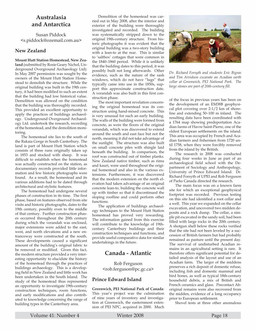
Volume 41: Number 4 Winter 2008 Page 18
Australasia and Antarctica
Susan Piddock<[email protected]>
New Zealand
Mount Hutt Station Homestead, New Zea-land (submitted by Rosie Geary Nichol, Un-derground Overground Archaeology Ltd): In May 2007 permission was sought by the owners of the Mount Hutt Station Home-stead to demolish the structure. While the original building was built in the 19th cen-tury, it had been modified to such an extent that the building had low historical value. Demolition was allowed on the condition that the building was thoroughly recorded. This provided an excellent opportunity to apply the practices of buildings archaeol-ogy. Underground Overground Archaeol-ogy Ltd. undertook the research, recording of the homestead, and the demolition moni-toring.
The homestead site lies to the south of the Rakaia Gorge in South Canterbury. The land is part of Mount Hutt Station which consists of three runs originally taken up in 1853 and stocked with sheep. It was difficult to establish when the homestead was actually constructed on the station, as documentary records provided little infor-mation and few historic photographs were found. As a result, the homestead and its various additions had to be dated through architectural and stylistic features.
The homestead had undergone several phases of construction in its time. The first phase, based on features observed from site visits and historic photographs, dates to the 19th century, possibly even to the middle of that century. Further construction phas-es occurred throughout the 20th century during which the verandah was enclosed, major extensions were added to the east, west, and north elevations and a new en-tranceway were constructed at the south. These developments caused a significant amount of the building’s original fabric to be removed or modified. Given this fact, the modern structure provided a very inter-esting opportunity to elucidate the history of the homestead through the practices of buildings archaeology. This is a develop-ing field in New Zealand and little work has been undertaken in the South Island. The study of the homestead thus represented an opportunity to investigate 19th-century construction techniques, room functions, and early modifications and also contrib-uted to knowledge concerning the range of building types in the Canterbury area.
Demolition of the homestead was car-ried out in May 2008, after the interior and exterior of the building were thoroughly investigated and recorded. The building was systematically stripped down to the original 19th-century structure. From his-toric photographs it was evident that the original building was a two-story building with a lean-to at the rear. This is similar to ‘saltbox’ cottages that were common in the 1840–1860 period. While it is unlikely that the building dates to this period, it was possibly built not long afterwards. Other evidence, such as the nature of the sash windows, which do not have “lugs” that typically came into use in the 1850s, sup-port this approximate construction date. A verandah was also built in this first con-struction phase.
The most important revelation concern-ing the original homestead was its con-struction using hand-mixed concrete. This is very unusual for such an early building. The walls of the building were formed from concrete, as were the floors of the original verandah, which was discovered to extend around the south and east face but not the north, meaning it did not take advantage of the sunlight. The structure was also built on small concrete piles with shingle laid beneath the building. In comparison, the roof was constructed out of timber planks. New Zealand native timber, such as rimu and kauri, were used throughout the origi-nal homestead and also in the various ex-tensions. Furthermore, it was discovered that the modern extension on the north el-evation had taken advantage of an original concrete lean-to, building the concrete wall up with timber so that it discontinued the sloping roofline and could perform other functions.
The application of buildings archaeol-ogy techniques to the Mount Hutt Station homestead has proved very rewarding. The information gained from this exercise will contribute to the knowledge of 19th-century Canterbury buildings and their construction techniques and functions, and provide useful comparative data for similar undertakings in the future.
Canada - Atlantic
Rob Ferguson<[email protected]>
Prince Edward Island
Greenwich, PEI National Park of Canada: This year’s project was the culmination of nine years of inventory and investiga-tion at Greenwich, the easternmost exten-sion of PEI NPC, acquired in 2000. Much
of the focus in previous years has been on the development of an EM38B geophysi-cal plot covering over 2-1/2 km of shore-line and extending 50–100 m inland. The resulting data have been coordinated with a 1764 map showing predeportation Aca-dian farms of Havre Saint-Pierre, one of the oldest European settlements on the island. This area was occupied by French and Aca-dian farmers and fishermen from 1720 un-til 1758, when they were forcibly removed from the island by the British.
The research in 2008 was conducted during four weeks in June as part of an archaeological field school with the De-partment of Sociology and Anthropology, University of Prince Edward Island. Dr. Richard Forsyth of UPEI and Rob Ferguson of Parks Canada directed the research.
The main focus was on a known farm site for which an exceptional geophysical footprint was recorded. Previous testing on this site had identified a root cellar and a well. This year we expanded on the cellar excavation, and uncovered two midden de-posits and a rock dump. The cellar, a sim-ple pit excavated in the sandy soil, had been filled with large rocks in the 20th century. A shotgun shell below these rocks verified that the site had not been leveled by a suc-cession of British farmers but had probably remained as pasture until the present day. The survival of undisturbed Acadian re-mains in an agricultural setting is rare. It therefore offers significant potential for de-tailed analysis of the layout and use of an Acadian farm. The larger of the middens preserves a rich deposit of domestic refuse, including fish and domestic mammal and bird bones, as well as typical 18th-century household debris, a mix of British and French ceramics and glass. Precontact Ab-original remains were also recovered from the midden, evidence of a long occupancy prior to European settlement.
Shovel tests at three other anomalous
Dr. Richard Forsyth and students Eric Bigras and Tim Arvidson excavate an Acadian earth cellar at Greenwich, PEI National Park. The large stones are part of 20th-century fill.

Volume 41: Number 4 Winter 2008 Page 19
areas along the shore confirmed traces of French occupation at each. This brings to seven the total number of 18th-century farm sites identified within the park boundaries. The farms all appear to have belonged to members of the Oudy family, identified in a 1752 census of the French colony. Tragi-cally, no one from this family appears to have survived the deportation to France in 1758. They were undoubtedly aboard one of two ships that sank en route.
Stanhope, PEI National Park of Canada: In response to interest from the local Stanhope Historical Society (SHS), Parks Canada ar-ranged a 1-week test excavation of two large depressions on the Farmlands Trail to determine if these were remains of 18th-century Acadian or subsequent Scottish settlement. Documentation prior to 1800 is extremely vague. Ten Acadian houses are shown in the Stanhope area on a 1764 map
by Samuel Holland, following the British removal of the occupants. Stanhope is also the site of the first Scottish settlement on PEI, dating to 1770.
Volunteers through the SHS worked with Parks Canada archaeologist Rob Fer-guson. One of the depressions appears to be just that, a large depression with no structural features, and no dateable arti-facts. The other feature appears to be the cellar of a late-18th- to early-19th-century residence. John Palmer, President of SHS, suggests the house may have belonged to David Lawson, land agent and overseer for the Stanhope farm between 1770 and 1788. As such it would be a significant part of the cultural resources within PEI National Park. Further excavation with the SHS may be possible in 2009.
Continental Europe
Natascha Mehler<[email protected]>
Shetland Islands
A German Trading site at Gunnister Voe, Shetland Islands (submitted by Mark Gar-diner and Natascha Mehler): Beginning in the early 16th century ships of the Hanse-atic League, the trading alliance of the ma-jor northern German cities, made their way across the North Atlantic to the Shetland Is-lands. The main item of exchange was dried fish which was obtained at trading places in Norway, Iceland, and the Faroe Islands as well as the Northern Isles of Scotland and brought back to the northern German ports. The character of this trade has yet to be investigated in detail. Although the bare historical outlines are known, the details of the interaction between the merchants from northern Germany who spent three to five months trading fish with the people of the Northern Isles still remain obscure.
The small trading site at Gunnister Voe in the Shetland Islands is one of the bet-ter documented trading sites. The right to trade here was granted to Simon Hager-skale of Hamburg in 1582, but was revoked in 1603 because it was said that hehad neglected to sail to Gunnister regularly in order to provide people with necessities. This is evidently the Simon Harriestede mentioned in Hamburg records as sailing to the Shetland Islands until 1625. The trad-ing site has been identified as the present-day place known as Hagrie’s Böd in Gun-nister Voe, a rocky promontory projecting
into the voe (an inlet or bay). Immediately behind the promontory is a beach with an enclosure which would have been suitable for landing boats bringing dried fish to ex-change.
In September 2008 excavations by a team composed of participants from Queen’s University of Belfast (GB) and the Roman-Germanic Commission of the German Ar-chaeological Institute (D) examined the site and revealed the surviving two walls of the böd or booth (see figures). However, depos-its below the floor level contained pottery of the 18th or 19th century, suggesting the site continued to be used or more probably had been reoccupied when the adjoining crofts at the Setter of Enisferth were established. The building is shown as abandoned on an 1881 Ordnance Survey plan, though the re-mains were evidently clear enough for the surveyors to map them. The excavations have been carried out as part of an inter-national research project on the operation of international trade in Iceland and the Shetland Islands (OITIS) from about 1400 to 1700.
Austria
Gold Mining and Smelting in the Alps: The gold deposits of the Hohe Tauern, one of the highest ranges of the eastern Alps, figured considerably in Austria’s economic history during the later Middle Ages and the early modern period. A number of the mining and refining sites and slag dumps remain visible to the present day. The min-ing areas were located in the high moun-tains, while the smelting plants were estab-lished in the valleys.
One of the Hohe Tauern gold-smelting plants has been excavated over the last few years by the Department of Prehistoric and Historical Archaeology at the University of Vienna. The site is located in the Anger Valley close to Bad Gastein, about 1300 m above sea level. The excavated features include three furnaces dating to the 16th
Members of the Stanhope Historical Society search for clues in a late-18th-century house cellar in PEI National Park.
The headland at Gunnister Voe during excava-tion in September 2008 (Photo by Mark Gar-diner).
The two surviving walls of Simon Harriestede’s trading site at Gunnister Voe (Photo by Nat-ascha Mehler).

Volume 41: Number 4 Winter 2008 Page 20
century. A smithy and living quarters of the miners have been documented during previous excavations at Lake Bockhart in the Goldberg Mountains in the near vicin-ity. The smithy’s purpose was to produce and repair the tools required for the mining and smelting process.
Archaeological excavations and histori-cal records help to paint a detailed picture of the early modern gold mining industry of the Hohe Tauern. After the gold ore was extracted from the mountains it was hack-led at the mine and then transported down into the valley by pack animals. There, at the furnaces, the ore was smelted and the gold extracted and distributed further af-terwards.
The funnel furnaces were erected on sol-id fundaments and are still standing; they are approximately 1.2 m in height. They are situated next to a stream which oper-
ated a mill wheel (which has been dendrochronologically dated to the early 16th cen-tury) that drove the bellows. The necessary charcoal was produced in the surrounding area and some of the slag was used for paving the paths that connected the features.
Amongst the finds are two metal lumps that accord-ing to archaeometallurgical analysis contain a consider-able amount of lead and sil-ver and thus are evidence of cupellation, the process by which noble metals are sepa-rated from base metals in an oxygen-deficient atmosphere at a temperature of more than 1000° Celsius.
For more details see Brigitte Cech, Spätmittelalterliche bis frühneuzeitliche Edelmetallgewinnung in den hohen Tauern. Monographien des Römisch-Germanischen Zentralmuseums 70 (Stuttgart: 2007); con-tact: <[email protected]> or <[email protected]>; and see web-site: http://histarch.univie.ac.at/index.php?id=24841
Great Britain and Ireland
Jim Symonds<[email protected]>
England
Tinsley Towers, Sheffield: Archaeologists from ARCUS at the University of Shef-field created a per-manent record of two iconic cooling towers in Sheffield before they were demol-ished in August 2008. The towers had been redundant for over 20 years, but their proximity to a major tow-tier viaduct car-rying the M1 motor-way and other trunk roads had prevented their demolition un-til suitable explosion techniques could be developed. The cool-ing towers, which were built in 1938, were the oldest of their type in the UK. To help mark the event, the team from ARCUS pho-tographed the towers and worked with the power company that owned them to create
a small exhibition, a commemorative book-let, and a set of postcards. A rare source of archive photographs was found that was used to chart the construction of the tower and the associated power station.
In October 1916, a report was commis-sioned to determine the suitability of sev-eral sites for construction of a new power station in Sheffield. This would satisfy the city’s increasing demand for power, and be crucial for the growth of industry in the Lower Don Valley. The site at Blackburn Meadows was chosen and the Sheffield Corporation Bill went before the House of Commons, and was adopted in 1917.
The site fell outside the Sheffield city limits and a series of land exchanges was eventually negotiated with Rotherham to allow the power station to be contained within the boundaries of Sheffield. Con-struction began in 1918. Eight generators and 40 boilers were installed: the plant required the largest amount of circulating water of any modern power station at the time. In dry weather the flow of water in the River Don was not enough to supply the condensers, so cooling towers were proposed. These would recirculate the wa-ter through the plant, and would be used
in times when the river was too low. The Blackburn Meadows Power Generating Station was opened in 1921 by HRH the Duke of York.
As Sheffield and her industry ex-panded, the need for electricity kept on
Wall remains of the 16th-century miners’ quarters near Lake Bockhart in the Goldberg Mountains, Hohe Tauern (eleva-tion about 2000 m above sea level) (Photo by Claudia Theune-Vogt).
Funnel furnace used in the gold-extraction process in the Anger Valley (Photo by Claudia Theune-Vogt).

Volume 41: Number 4 Winter 2008 Page 21
growing, and a second generating station was opened in 1933. Greater generating capacity required greater water cooling facilities—in 1937–1938, cooling towers 6 and 7, the ‘Tinsley Towers,’ were built. These were in a new style designed by LG Mouchel and Partners. Their distinctive hyperbolic curve made them very different from the existing square towers. The walls, a mere 12 cm thick, were formed of poured and reinforced concrete. The banding and perforations at the tops of the towers are unusual, and may have been experimen-tal design features. The site seems to have attracted engineering innovation. In 1968 the Tinsley Viaduct brought the M1 and the A631 across the Don Valley. This two-tier bridge was the first of its kind in the UK, and was built at a cost of £6 million.
The electricity industry was national-ized in 1948, ending Sheffield Corporation’s connection with Blackburn Meadows.
Postcards (presentation set of 10) and booklets are available, for £5 each from:Anna BadcockARCUS, Unit R6, Riverside BlockSheaf Bank Business ParkProspect RoadSheffield S2 3ENUnited Kingdomemail: <[email protected]>
All funds raised from the sale of these will be donated to the Rotherham Hospice and Neurocare at the Royal Hallamshire Hospital, Sheffield.
Underwater News (Worldwide)
Toni Carrell<[email protected]>
New Mexico
NPS, Submerged Cultural Resources Cen-ter: The two main projects the National Park Service’s Submerged Resources Cen-ter (NPS-SRC) continued in 2007 were the USS Arizona Preservation Project and a multiyear study of inundated and emergent historic and prehistoric sites at Lake Mead National Recreation Area. In addition, we participated in 14 projects of varying dura-tion at parks such as Channel Islands NP, Isle Royale NP, and Biscayne NP. Finally, SRC continued the initial phase of a joint NPS/NOAA/UC-Berkeley project in Point Reyes National Seashore to locate and eval-uate historical shipwrecks in Drakes Bay.
The NPS-SRC continued to compile a draft report on USS Arizona in Pearl Harbor, HI as part of a multiyear, interdisciplinary
project to characterize critical processes affecting Arizona, develop a predictive en-gineering model to calculate diminishing structural integrity over time, and produce a long-term preservation plan for the bat-tleship including management alternatives. This is an issue that continues to attract the attention of managers and the general pub-lic due to the iconic nature of the wreck and the ongoing seepage of oil from the ship’s fuel bunkers.
The SRC also continued work on sub-merged sites in Lake Mead National Recre-ation Area, including a B-29 Superfortress in 150 ft. of water and industrial sites asso-ciated with Hoover Dam construction ap-proximately 120–140 ft. deep. Daniel Leni-han was project director and Dave Conlin was field director.
SRC continued to consult with NPS ar-chaeologists and resource and project man-agers on removal of the wreck of the ferry Ellis Island from the Statue of Liberty/Ellis Island Immigration Museum. Removal of the wreck is a priority for the park prior to rehabilitation of the seawall and south side development at Ellis Island. Conlin is working closely with park and regional personnel, as well as the New York and New Jersey SHPO offices, to develop a documentation plan for wreck removal in 2008.
SRC is also closely involved in the plan-ning and review of proposed dredging activities in the upper Hudson River adja-cent to Saratoga National Historical Park, NY. The upper Hudson River was heav-ily contaminated with PCBs originating at the General Electric facility in Fort Ed-wards. Proposed dredging activities will likely have an adverse effect on submerged resources in the river and SRC is working closely with the park, General Electric, and the Environmental Protection Agency to mitigate these impacts.
Finally, SRC continued the preliminary phases of a joint NPS/NOAA/UC-Berke-ley project to locate, document, and evalu-ate submerged cultural resources in Drakes Bay, CA within Point Reyes National Sea-shore. Remote sensing in 1997–1998 result-ed in location of dozens of buried magnetic anomalies that have not yet been evaluated. The planned project will begin anomaly in-vestigation in a phased approach beginning in 2008. At the same time, Russell began to evaluate museum collections of 16th-cen-tury artifacts from the Spanish Manila gal-leon San Agustin excavated from terrestrial Coast Miwok sites in the 1940s and 1950s in an ongoing reanalysis of the material.
Washington, DC
Naval Historical Center (NHC), Underwa-
ter Archaeology Branch (UAB): The NHC’s UAB assists the Director of Naval History and the Department of the Navy in all mat-ters related to the science of underwater ar-chaeology and the identification, research, interpretation, preservation, conservation, inventory, and management of the U.S. Navy’s historic ship and aircraft wrecks and their associated contents. These cul-tural resources fall under the protection of the U.S. government and the jurisdiction of the U.S. Navy (USN). With the recent additions of Alexis Catsambis and George Schwarz, and following a reorganization of the Naval Historical Center (NHC), UAB has extended its capabilities and scope and is actively engaging in a number of areas. Beyond ensuring USN compliance with the federal archaeology program and promot-ing public outreach and education, during the past year UAB has focused its attention on the few key aspects outlined below.
Sunken Military Craft Act: Perhaps the most significant undertaking the UAB has been involved with in recent months has been the drafting and review of the regu-lations for the Sunken Military Craft act (SMCa). The SMCa is important in the protection of the USN’s underwater cul-tural heritage because it ensures that the U.S. maintains the right, title, and interest in and to any U.S. sunken military ship or aircraft regardless of the passage of time, without express divestiture of title. In ad-dition, protection is afforded against dis-turbance, removal, or injury to sunken U.S. military craft, and their associated contents, wherever they may be located. The act also provides a mechanism for permitting in-trusive archaeological investigation of sites for approved purposes and puts in place civil enforcement measures to prevent un-authorized disturbance. Finally, the act encourages bilateral and multilateral agree-ments with foreign countries for the protec-tion of sunken military craft; upon request by a foreign state, permitting regulations that apply to U.S. military craft may be ex-tended to any sunken military craft of that foreign state located in U.S. waters.
This latter section of the act recognizes that the U.S. has much to gain from recip-rocal agreements with other states with regard to the protection of sunken military craft. While the UAB maintains a database identifying more than 1,400 USN sunken military ships and almost 6,300 aircraft that are located or believed to be located within U.S. waters, more than 1,600 ships and nearly 8,500 aircraft are believed to lie outside these waters.
Permit Granting: Under current regula-tions 32 CFR 767, the UAB has also been occupied with reviewing and granting per-mits to conduct archaeological research on

Volume 41: Number 4 Winter 2008 Page 22
USN sunken craft. A recent case involved the survey for USS Chippewa (1815–1816) and USS Onkahye (1840–1848) conducted by Ships of Discovery in the Turks and Caicos Islands. The expedition was able to locate the wreck site of USS Chippewa, and is planning on returning next year to document the site and continue the search for USS Onkahye. Another recent project that was permitted involved the recovery of artifacts from USS Saginaw by members of NOAA’s Office of Marine Sanctuaries. The lead sounding weight and bell that were raised are now undergoing conserva-tion and will be exhibited to the public, for-warding the public outreach and education mission of both organizations.
Bonhomme Richard Survey Project: For the past few years the UAB and Ocean Technology Foundation (OTF) have been actively searching for the remains of Bon-homme Richard, flagship of American na-val officer John Paul Jones. Jones’s vessel, a French East Indiaman turned warship, sank in the North Sea in 1779 after the famous encounter with the 44-gun HMS Serapis at the Battle of Flamborough Head. The battle ensued after Jones, who had spent several weeks captur-ing or sinking British vessels off the British Isles, spotted and en-gaged a Baltic convoy that was instrumental for maintaining Eng-land’s naval dockyards. For three and a half hours the battle raged at point-blank range, and though Jones emerged the victor, Bon-homme Richard could not be sailed. As Jones transferred his wounded men to the captured Serapis, he watched his own ship list and sink from the tremendous damage her hull had sustained.
Previous surveys conducted by OTF in conjunction with NHC were executed in 2006 and 2007, but proved inconclusive. This past summer, with the assistance of the U.S. Navy Submarine Force, the survey team applied the technology of the nuclear research submarine NR1. Incorporating the sonar devices and virtually nonstop opera-tional capabilities of NR1, the mission was to survey predetermined grids which were plotted in the software program ArcGIS.
Other collaborators include Peter Reave-ley, a researcher who has been analyzing the Battle of Flamborough Head and the sinking of Bonhomme Richard for 35 years, and Dr. Peter Guth, Professor of Oceanog-raphy at the Naval Academy in Annapolis, who created the computer program that generated the team’s drift models.
Using the research conducted by the team over the past several years, drift mod-
els were created which suggested the most likely directions in which the battered Bon-homme Richard would have been carried before its eventual sinking. With the assis-tance of the United Kingdom Hydrograph-ic Office (UKHO), OTF was able to obtain hydrographic data for the projected search area. The data provided by the UKHO in-cluded GIS positions for shipwrecks, bot-tom features such as sand waves and oil pipelines, trawl marks, and fishermen’s obstructions. Using ArcGIS to plot the known wrecks in the search area, the team was able to designate priority search grids which could be relayed from the support vessel to the operators of the submarine via UHF radio.
NR1 was the primary survey vessel for this expedition. It is equipped with an Ob-stacle Avoidance Sonar (OAS) as well as side scan sonar. With these devices, NR1 was able to detect shipwrecks and debris fields within the ranges of the sonar that
were lying on the sea bed. Ferrous obstacles showed up as amorphous red contacts on the OAS, indicating iron objects. Large blue contacts on the OAS were possible signs of shipwrecks, and were tracked and investi-gated at the opportune time. NR1’s equip-ment was able to detect numerous potential targets which were examined in detail. In-vestigation of each target consisted of mak-ing several passes around the shipwreck, recording extensive video from multiple video cameras, documenting archaeologi-cal features based on video and viewport observations, and capturing well-defined side scan images.
During the latter part of the field sea-son a magnetometer became available for use. Because Bonhomme Richard is esti-mated to have sunk with over 220 tons of iron (between cannon and pig ballast), the shipwreck is expected have a prominent magnetic signature. The use of the magne-
tometer confirmed that several of our tar-gets did contain varying degrees of iron.
The nuclear submarine began the sur-vey on 11 June in the primary search grid, which was determined by the drift model research. Two wrecks in this area were considered to be possible Bonhomme Richard candidates, but upon further investigation were dismissed as a modern iron-hulled vessel and a wooden trawler. Four days later, the team directed NR1 to numerous wrecks that were listed as unidentified on the UKHO charts. The remaining days, from 17 June to 1 July, were spent survey-ing the secondary search areas in an effort to cover as large an area as possible. The OAS picked up numerous contacts and the crew investigated the high-priority targets as time allowed. Upon completion, the NR1 had surveyed over 375 mi.2 in the North Sea.
The amount of raw data that was col-lected during the survey is vast, and several
days of continuous video were recorded for analysis. The team is still in the process of sorting through the data and prioritiz-ing potential Bonhomme Richard targets. Out of 18 contacts that were located, 9 were found wor-thy of further investigation. The wooden wrecks that are partially buried are of the highest priority, and will be assessed for diagnos-tic features associated with the expected remains of Bonhomme Richard. Some of these features would include a wooden hull with limited iron reinforcements (knees), a large assemblage of iron cannon and ballast, robust frames and other structural ele-ments, and a deteriorated hull
(due to poor preservation and heavy dam-age sustained from the naval battle).
Further surveying is required, but this summer the team effectively narrowed the search area by systematically eliminating several listed wrecks and large survey ar-eas that were considered viable options as the possible location of the shipwreck. In addition, there are now five wooden ship-wrecks that have the potential to exhibit features diagnostic to Bonhomme Richard, to be determined after further review of available data and future surveys. Plans are currently underway for a possible 2009 follow-up survey of the narrowed search area utilizing magnetometers, ROVs, side scan sonar, a multibeam echo-sounder, and a sub-bottom profiler.
Loan Program: In tune with the NHC re-structuring, UAB has recently been tasked with managing the loan agreements for the Navy’s submerged material culture, a duty
NR-1 and crew at Portsmouth prior to departing for the survey area (Photo by George Schwarz, NHC, UAB).

Volume 41: Number 4 Winter 2008 Page 23
that was previously performed by the Cu-rator Branch. Recently, a loan program was implemented and the artifacts from various submerged Navy sites have been put on loan to national and international muse-ums, including La Cité de la Mer (France) and the Museum of Mobile (AL). These loan agreements were designed to ensure not only that important and interesting Navy artifacts are made available for pub-lic display and study, but also that they are routinely monitored for condition assess-ment and safekeeping.
The UAB looks forward to furthering its efforts in preserving and sharing the Na-vy’s underwater cultural heritage through the continuation of ongoing initiatives and further collaborations with institutions that share in the NHC’s objectives. Future proj-ects range from the publication of impor-tant reports on H. L. Hunley and the D-Day Landings to developing projects that will highlight the Navy’s contribution to the War of 1812 in the upcoming bicentennial commemoration. For more information on the NHC and the UAB, please visit our soon-to-be-renovated website, http://his-tory.navy.mil.
Australia
Maritime Archaeology Program, Flinders University: The Maritime Archaeology Program, in conjunction with the Flinders University Department of Archaeology, Australasian Institute of Maritime Archae-ology (AIMA), Australasian Society for Historical Archaeology (ASHA), and Aus-tralian Association for Maritime History (AAMH), organized and hosted the 2008 AIMA/ASHA/AAMH Annual Archaeol-ogy Conference in Adelaide, SA. The con-ference theme, “Archaeology from Below: Engaging the Public,” was derived from the 1960s movement “History from Below,” which motivated historians to shift their fo-cus from topics such as great men, big wars, and political elites to subjects that previ-ously had been neglected such as women, children, the urban and rural poor, immi-grants, and ethnic minorities. Over 130 at-tendees took part in the conference, which included more than 70 presenters in nine sessions covering a variety of topics and themes. The conference also featured six distinguished international guest speakers, a free public presentation about the discov-ery of the Australian warship HMAS Syd-ney (II), and interactive workshops. James Hunter, a new Ph.D. student in the Mari-time Archaeology Program, won the Best Student Paper Award at the conference for his presentation “One-Hit Wonders: The ‘Russian Scare’ and the Rise of Colonial Australasian Torpedo Boats.”
Flinders University researchers Jen-nifer McKinnon and Jason Raupp teamed up with Australian National University re-searcher Daryl Guse to investigate Macas-san maritime industries that once occurred in Anuru Bay, Arnhem Land, Northern Territory. This is an important aspect to understanding Indigenous Australian in-teraction with the Macassans and the depic-tions of these people and their watercraft in the area’s rock art record. For two weeks researchers conducted excavations at Ma-cassan treepang (sea slug) processing sites, conducted marine surveys within intertidal areas, and surveyed the natural and cul-tural features of the land and seascape for Macassan and Indigenous Australian mari-time heritage. This survey and excavation of Macassan sites is the first research-driv-en investigation into Macassan activities in 30 years.
Maritime Archaeology Program Ph.D. student Claire Dappert received a Flinders University Overseas Traveling Fellowship, a prestigious and competitive award be-stowed annually on one university doctoral candidate. As part of her fellowship, Dap-pert interned with the PAST Foundation under the direction of Dr. Sheli Smith to analyze and interpret the artifact collection recovered from Frolic, a shipwreck exca-vated by the PAST Foundation in 2003 and 2004. The fellowship also enabled her to conduct research in a number of museums and libraries, including the Peabody Essex Museum, U.S. Library of Congress, U.S. National Archives, and New York Public Library, as well as consult with archaeolo-gists affiliated with several state agencies and university programs. Dappert intends to complete her dissertation in early 2009.
New Maritime Archaeology Program staff member Amer Khan was lead train-er at the UNESCO Advanced Training of Trainers Workshop, held between 20 March and 10 April 2008, in Galle, Sri Lanka. The 3-week workshop included a number of archaeology and cultural heritage man-agement instructors from the Asia-Pacific region, as well as 14 participants from Sri Lanka.
Ph.D. student Jun Kimura is currently engaged in a number of projects related to his thesis topic. His primary focus is the ar-chaeological study of medieval East Asian shipwrecks, an interest that originated from his experience working at the Mongo-lian invasion site in Japan. He is working in cooperation with the Institute of Nautical Archaeology at Texas A&M University to investigate an historic battle site associated with the Mongolian invasion of Vietnam. Jun is also developing a regional shipwreck resource on the Internet in collaboration with other East Asian researchers; this proj-
ect is fully supported by the Toyota Foun-dation in Japan.
In October the Australian Research Council (ARC) released the results for ARC Linkage Grant funding in 2009. The Mari-time Archaeology Program’s proposal, “The South Australian Historical and Mari-time Archaeology Management Project,” was awarded total funding of $78,420 for the years 2009–2011. The Maritime Archae-ology Program received support in this en-deavor from research partners in the South Australian Department of Environment and Heritage, South Australian Maritime Museum, and Archaeological & Heritage Management Solutions. The funding will be used in part to support Flinders doctoral student Adam Paterson, who will take up an APAI postgraduate scholarship in 2009.
Canada
Underwater Archaeology Service (UAS) Parks Canada: The field season began in April 2007 when a team from Parks Can-ada’s Underwater Archaeology Service (UAS) team conducted a 1-week side scan sonar survey of the Hamilton and Scourge Shipwreck Site in Lake Ontario. These armed American schooners sank during a sudden squall in August 1813 near the mouth of the Niagara River. Discovered in 1973, they have been the subject of intermit-tent archaeological investigation since then, notably in 1982 and 1990. The UAS pro-vides underwater archaeological guidance and expertise to the City of Hamilton and is working closely with another of the city’s technical partners, ASI Group of St. Catha-rines, ON. Using its Klein 3000 side scan sonar, the UAS and ASI completed a sonar mosaic of a 2 x 1.2 km area encompassing the wrecks as well as close-up imaging passes of each wreck and their immediate debris fields. Results from the sonar survey are being added to a site GIS and will be scrutinized to extract accurate scale dimen-sion data on the wrecks, which will greatly assist in the planning for a series of ROV inspection dives planned for 2008.
In May and June the UAS returned to the Trent-Severn Waterway National His-toric Site of Canada. The 6-week project marked the final year of the submerged cul-tural resource inventory of the waterway. Highlights of this year’s survey include the documentation of a shipwreck graveyard in Peterborough; the side scan sonar sur-vey from Campbellford to Trenton; and the monitoring of a prehistoric weir site at Sun-set Bay. With the majority of the fieldwork complete, the focus is now on inputting the data into a GIS and report writing.
Also in June the UAS trained for one week at Fathom Five National Marine Park,

Volume 41: Number 4 Winter 2008 Page 24
building on last year’s experience using closed-circuit rebreathers. This training in-cluded a skills refresher, photo and video work, and the reconnaissance of several wreck sites in anticipation of the monitor-ing work in the fall.
In June and July, the UAS continued an earlier side scan sonar survey initiated in 2004 in Lake Superior. A 3-week field project focused on inventorying a ship-wreck graveyard dating to 1936 when over three dozen derelicts were removed from the nearby harbors of Port Arthur and Fort William, neighboring municipalities which later amalgamated into the present-day city of Thunder Bay. An area in excess of 5 x 5 km was systematically surveyed in 2007 with nine of the wrecks, lying at depths beyond 250 feet, ultimately being exam-ined by ROV. The most significant vessel remains to be identified were those of the Druid, a Confederate blockade runner built in Scotland in 1856. In the course of the U.S. Civil War, Druid completed eight success-ful smuggling runs between Charleston, SC and Nassau in the Bahamas. At war’s end, Druid was sold to the new Dominion Government of Canada, which operated the vessel for the following 35 years. The object of the 2007 Lake Superior survey was to determine the overall extent of the grave-yard site and to assess the historical value of the various derelicts interred therein to see if this collection of wrecks potentially merited inclusion in the new Lake Supe-rior National Marine Conservation area an-nounced by the prime minister in October.
A 2-week field project was conducted in August in the Mingan Archipelago Nation-al Park Reserve of Canada. The Mingan Archipelago is located on the north shore of the Gulf of St. Lawrence in the Province of Québec, approximately 225 km east of Sept-Iles. The more than 1,000 islands and coastal islets are spread over a 150 km long territory of approximately 112 km2. This territory has been occupied for 6,000 years and testimonies of European presence go back to the Basques and then the French who established a trading post in the late 17th century. In the mid-19th century, more permanent settlements were estab-lished by fishermen coming mainly from the Magdalene Islands and Acadia. The objectives of the 2-year project planned for 2007 and 2008 are to document shipwreck remains in order to supplement the upcom-ing interpretation of the two lighthouses of the archipelago (1888 and 1915). The 2007 campaign’s aim was to test the methodol-ogy and to familiarize the team with the diving and remote sensing conditions. The oldest shipwreck documented in the ar-chives is the Clyde, an 1857 steamer with propeller, although there are likely to be
older wrecks. The 2007 work yielded inter-esting results: two possible new sections of hull of the Clyde were identified with side scan sonar as well as what seems to be the anchor.
In September a UAS team of Jonathan Moore and Ryan Harris returned to Gwaii Haanas National Park Reserve and Haida Heritage Site (Queen Charlotte Islands, BC) for two weeks. The UAS is working with Parks Canada archaeologist Daryl Fedje and his colleague Dr. Quentin Mackie of the University of Victoria to locate submerged prehistoric sites on drowned landscapes dating to 11,000 years BP that are found at depths of approximately 130 ft. (40 m). This year’s objective was to use a Klein 3000 side scan sonar and integrated S3000 ‘Chirp’ sub-bottom profiler to map the outlet of a submerged lake as well as to conduct ROV inspection dives in high-priority areas. The UAS was fortunate to have Garry Kozak of L3-Klein Associates accompany the team and provide the above-mentioned sub-bot-tom profiler gear. The UAS plans to return next year to conduct subsurface bottom sampling in search of archaeological sites.
The final project of the season took place in September and October when the UAS revisited Tobermory to conduct the Shipwreck Monitoring at Fathom Five Na-tional Marine Park (FFNMP). The Historic Resource Conservation Branch of Parks Canada first instituted this program back in 1992. Over these last fifteen years, staff members from Parks Canada (Archaeologi-cal and Historical Conservation, Analytical Services, UAS, FFNMP), Canadian Conser-vation Institute (CCI), Technical Operations of the National Water Research Institute, and volunteers have collected the data for the monitoring program. Archaeological and Historical Conservation, Analytical Services, and the UAS will analyze the re-sults in the coming year, and provide rec-ommendations to FFNMP.
The summer of 2007 was very busy for Parks Canada’s NAS tutor team. Four in-troductory courses, three Level 1 courses and one Level 2 course were given. Cours-es were used to support partners including the new Save Ontario Shipwrecks (SOS) Montreal-based chapter and the Groupe de préservation des vestiges subaquatiques de Manicouagan (GPVSM) who participated with Parks Canada in the 1996–1997 exca-vation of the Elizabeth and Mary (1690) in Baie-Trinité, QC. Courses were also used to help promote the proposed National Marine Conservation Area (NMCA) in the Magdalene Islands, also in Québec. In May, Chris Underwood of NAS and Marc-André Bernier of Parks Canada trained new tutors from the NOAA Marine Sanctuary Pro-gram. The training was held in Alpena, MI,
at the NOAA Thunder Bay Marine Sanctu-ary facilities.
Of particular significance this year is the publication of The Underwater Archaeology of Red Bay. This report primarily describes the excavation and research conducted on the 16th-century Basque whaling vessel in Red Bay, Labrador, believed to be the San Juan (1565). This five-volume work is available for purchase, in both French and English editions.
UNESCO Committee News
The 2001 UNESCO Convention on the Pro-tection of the Underwater Cultural Heri-tage (Convention) will enter into force on 2 January 2009. This milestone has been achieved according to Article 27 in the Con-vention, whereby it enters into force three months after deposit of the 20th instrument of ratification, acceptance, or approval by Member States of UNESCO. On 2 October 2008, Barbados became the 20th State Party to accept the 2001 Convention. The first 20 States to join have the privilege of appoint-ing a Technical and Scientific Advisory Body. As each subsequent country ratifies, after a 3-month waiting period, the Con-vention will also apply to that country.
UNESCO classifies the world into five regional areas: Africa, Arab States, Asia and Pacific, Europe and North America, and Latin America and the Caribbean. The 20 countries that have joined the 2001 Convention include: Panama (20/05/03), Bulgaria (06/10/03), Croatia (01/12/04), Spain (06/06/05), Libyan Arab Jamahiriya ((23/06/05), Nigeria (21/10/05), Lithuania (12/06/06), Mexico (05/07/06), Paraguay (07/09/06), Portugal (21/09/06), Ecuador (01/12/06), Ukraine (27/12/06), Lebanon (08/01/07), Saint Lucia (01/02/07), Roma-nia (31/07/07), Cambodia (24/11/07), Cuba (26/05/08), Montenegro (18/07/08), Slove-nia (18/09/08), and Barbados (02/10/08). Three-quarters of the signatories are from Europe and Latin America and the Carib-bean. So far, there are no ratifications by North American countries.
In 1999, the Society for Historical Ar-chaeology established the UNESCO Com-mittee to monitor development and negoti-ation of this Convention. With its adoption at the 31st General Conference of UNESCO in 2001, the committee’s role changed to supporting its international ratification and implementation, and the adoption of its Annex as a best practices document even in areas where ratification is unlikely. The coming into force of the 2001 Convention marks the important third stage in its histo-ry, and the beginning of a process whereby it becomes a truly international instrument for the protection and management of the

Volume 41: Number 4 Winter 2008 Page 25
world’s fragile, finite, and irreplaceable un-derwater cultural heritage.
U.S.A. - Alaska
Doreen Cooper<[email protected]>
Community Archaeology at the Baranov Museum, Kodiak, Alaska (submitted by Mark S. Cassell, Territory Heritage Re-source Consulting, Anchorage): During the last ten days of June 2008, the Baranov Mu-seum of Kodiak sponsored a community ar-chaeology project on its property and in the
adjacent Sargent Park to celebrate the 200th anniversary of the A.D. 1808 construction of the Russian-America Company magazin (warehouse), which houses the Baranov Museum. Also known as the Erskine House National Historic Landmark, the magazin is the oldest standing building in Alaska and the earliest documented wooden build-ing on the U.S. West Coast. The Baranov Museum Bicentennial Archaeology Project was coordinated with its Kodiak Historical Society parent and included support from the City of Kodiak and the National Trust for Historic Preservation.
As initially conceived by Baranov Mu-seum Executive Director Katie Oliver, this project was intended to involve local com-munity volunteers and students along with professional archaeologists to understand the entire human land use history of this small part of the present-day city of Ko-diak. Mark Cassell (Territory Heritage Re-source Consulting, Anchorage) served as principal investigator, with Margan Grover (Bold Peak Archaeological Services, Ek-lutna) as field director and Patrick Salton-stall (Alutiiq Museum, Kodiak) supervising volunteers. We were honored to have the assistance of Dr. Don Clark, longtime sub-arctic archaeologist and native of Kodiak. The archaeological excavations amounted to just 10 m2 of the 4500 m2 of the proper-
ties, or a 0.22% sample. In the course of its expectedly brief but surprisingly successful run, the project documented approximately 3500 years of human land use at this little piece of Kodiak. All this was conducted by dozens of volunteers and students and witnessed by hundreds of community and cruise ship visitors.
The history of the Baranov Museum and Sargent Park study block is nested within that of Kodiak. While no pre-European archaeological sites had previously been found within the city, sites occur through-out the Kodiak archipelago representing ar-chaeological traditions dating from ca. 5500 B.C. to A.D. 1750; the latter date is roughly consonant with the development of region-al indigenous Alutiiq society. The Russians set up a permanent post on Kodiak Island in 1784, and the Russian-America Com-pany (RAC) established its Alaskan capital at the present city of Kodiak in 1792, using Native Alaskans as the primary fur trade labor source.
In 1867, Russia transferred Alaska to the U.S. government, including the RAC hold-ings. With transfer, the Alaska Commercial Company (ACC) obtained a commercial monopoly, using the previous RAC facili-ties in Kodiak and being headquartered at the 1808 RAC magazin. W. J. Erskine joined the ACC as Kodiak factor in 1908, and in 1911 bought out the ACC’s Kodiak inter-ests, including the magazin, where he set up his own commercial company and lived with his wife, renowned for her extensive, successful, and innovative gardens. The Erskines built an annex onto the magazin which, like many buildings in the city and region, collapsed from the heavy ashfall of the 1912 Mt. Novarupta volcanic eruption (known as the Katmai eruption). Mr. and Mrs. Erskine resided in the magazin build-ing until their deaths in the 1940s. Next to the Erskine’s magazin residence, the Sar-gent family built their house about 1910.
World War II brought tens of thousands of American military personnel to Kodiak Island and the city, and the expansion of the city that had proceeded at a modest pace since 1792 suddenly exploded in a frenzy of develop-ment. Residential, commercial, and agency buildings were set up in the study block. Tenants spo-radically used the magazin for residential and/or commercial purposes into the 1960s, and the building soon fell into disrepair.
The 1964 Good Friday earth-quake in south Alaska created a tsunami that leveled much of Kodiak, spawning what is locally known as the “urban renewal” period: much of the existing city
was bulldozed to remove traces of prior un-planned development and to begin anew. The magazin and adjacent block, located on a low bluff in Kodiak, were not dam-aged by the tsunami. Nonetheless, existing structures on the study block were razed during “urban renewal,” leaving only the magazin standing. The rapidly deteriorat-ing building found its salvation in the 1967 creation of a community museum there by the Kodiak Historical Society. Enclosing the area that once contained a microcosm of life in Kodiak, the current grass-covered Sargent Park was created in 1980, with only a modicum of hand grubbing to modestly level the ground surface.
Period illustrations, maps, and photo-graphs from the 1790s into the 1950s de-scribe a burgeoning and then-vibrant social and material landscape in the study block surrounding the magazin, as represented by the presence of and changes in numer-ous buildings, fences, and roads. This ar-chival background, together with known artifact finds on the property, formed the basis for the excavation areas. Four loca-tions were chosen for excavation on the museum and park properties. To the north of the magazin, two 1 x 1 m units were picked due to the suspected proximity to the annex collapse after the 1912 ashfall; it was hoped that these units would yield in-formation concerning the building interior vs. exterior due to changes in construction and ashfall content. Two 1 x 1 m units were opened to the northwest of the magazin to see what might exist amidst the structures shown there in period graphics. West of the magazin, near the back door of the former Sargent house, two 1 x 1 m units were laid out to see if any remains could be found di-rectly related to the Sargent tenure. Finally, two adjacent sets of two 1 x 1 m units were opened immediately south of the magazin, as gardening activities a couple years back had yielded a number of Russian-era mate-rials there.
In the north excavations, we did find the remains of the collapsed magazin an-
Baranov Museum (left center) and surrounding Sargent Park properties in Kodiak.
Community volunteers and students excavating.

Volume 41: Number 4 Winter 2008 Page 26
nex, with clear distinctions in assemblage and the 1912 ashfall delineating exterior from interior. As digging progressed, we encountered a dense layer of worked-wood fragment in muddy soils, a matrix which also included broken flat glass, ceramics, and an Alutiiq woven spruce-root basket in remarkably good condition and likely dat-ing to the early 19th century. Local spruce-root weavers examined the basket after its removal, exulted over its integrity and in-tricacy, and speculated that about two full years were required from the root gathering to basket completion. (The Alutiiq basket is currently in conservation.) Further excava-tion into the wet soils found boulders and more wood, and discovered the reason for the character of the muddy assemblage: the area was a former wetland, and the wood, boulders, and midden material (including the basket) were deposited to reclaim it.
In the northwest excavations, we found a scene of destruction, with tumbled and broken concrete and lumber; Russian-era ceramics were found in upper layers and a plastic straw was found toward the bot-tom. This represented the post-tsunami “urban renewal,” the bulldozing of existing postwar development. At the very bottom were found numerous Russian-era materi-als, clearly below the limit of destruction.
In the west excavations, we found an upper layer of dirt overburden over an in-tact layer of sod, under which lay domestic material culture items dating to the late 19th to mid-20th century, including numerous toys. The sod is the 1964 surface (remark-ably undisturbed in the chaos of razings), and the underlying artifact assemblage likely represents the ca. 1910–1964 Sargent occupancy. (Excavations here were ap-propriately halted early by HAZWOPER-certified Grover due to petroleum hydro-carbons showing up in the unit after rains flooded it.)
In the south excavations, only a few meters from the standing magazin, we found a gunflint, and then an intact spruce plank floor on which it sat. Opening units nearby, we found a wood sill and another intact floor section, oriented sufficiently
askew from the first to consider it a separate floor. Both floors are well below the level of the magazin. We had thus found two buildings in a location none had been documented previously. The many early illustra-tions and later photographs existing of the locale since the 1790 depict no buildings here before 1808 and only the magazin here after 1808. Or so we thought: a closer look at a ca. 1796 drawing by the reliable observ-er James Shields shows three small buildings immediately south of where the magazin would later stand. It ap-
pears that the plank floors may represent two of these pre-magazin buildings, and if so, are the earliest remains found of RAC presence in Kodiak (the spruce plank floors were left intact).
While excavating the units containing the second spruce floor, we encountered an intact line of rocks immediately below the present sod. Knowing that this area held one of the numerous Erskine gardens, we asked after a photograph of her gardens. One was found from ca. 1920–1930 show-ing a rock-bordered garden path. We had found Mrs. Erskine’s garden path, lying undisturbed though decades of develop-ment. For much of the Kodiak community, in which the Erskine tenure is still fondly recalled by the many people who knew them, this discovery was understandably the highlight of the project. (Mrs. Erskine’s garden path border was left undisturbed.)
When Dr. Clark arrived at the Baranov Museum for this project, he stood on the little bluff overlooking the sea just a stone’s throw away and said, “This part of Kodiak wasn’t hit by the tsunami. And it’s good access to the water. If there’s a prehistoric site anywhere in town, it’s here.” And he was correct: on the final day of the proj-ect, while digging through soils below and outside the spruce plank floors, we found many red jasper flakes. These appear to date to the pre-European Early Kachemak period of ca. 1900–200 B.C., and likely ear-
lier in that period.It is not a surprise that about 4000 years
of history exist at this part of Kodiak. It is remarkable that this project was able to document the long trajectory of human land use, from Early Kachemak to the exist-ing landscape, at this little place with such a small archaeological excavation sample. This is a testament to the tremendous re-source presence within this little acre of his-tory surrounding the Baranov Museum.
U.S.A - Gulf States
Kathleen H. Cande<[email protected]>
Arkansas
Archaeological Investigations at the Maz-zanti Site (3CH187), Lake Chicot, Arkan-sas (submitted by William McAlexander): Staff from the Arkansas State Highway and Transportation Department investigated an 1830s–1970s domestic site along the bank of Lake Chicot in southeast Arkansas from 2006 to 2008. Work included extensive ar-chival research, informant interviews, met-al detector survey, shovel testing of an ag-ricultural field, and excavation of a series of 50 x 50 cm column samples. Approximately 1,058 liters of material was excavated.
The archival search indicated that the property was owned by Chester Ashley from around the mid-1830s until his death in 1848. Ashley was a prominent lawyer, land speculator, slave owner, and politician who lived in Little Rock, AR in the early to mid-19th century.
Site 3CH187 contained artifacts mostly from the early 19th century up through current times. Excavations revealed four distinct episodes; a prehistoric, an early-19th-century, a late-19th-century, and an early-20th-century occupation.
Excavations were geared towards gar-nering information about the earlier 1830s–1840s component. The site is in some way associated with an absentee landowner antebellum plantation. Unfortunately, nei-ther archival nor archaeological informa-tion was uncovered that would help with determination of either an overseer or slave habitation. The only architectural informa-tion that could be gleaned was from square nails, indicating the structure may have been wood framed.
Ceramics were used to date the site. Fine wares included pearlware, whiteware, and porcelain with mocha, flow blue, blue shelledge, and blue, black, brown, and green transfer-printed decorations. Coarse wares included stoneware, redware, yellow
Dr. Clark excavating north Erskine annex collapse, with dashed line dividing structure exterior (left) from interior (right); Katmai ash is white lens.
1796 illustration showing three small RAC buildings (in circle) south of future magazin location (at arrow).

Volume 41: Number 4 Winter 2008 Page 27
ware, and white ironstone with a variety of glazes, slips, and banding. Commercial wares, ceramics produced for the distribu-tion and transfer of goods in a market atmo-sphere, included an unidentified impressed stoneware bottle fragment and three pieces from a ginger beer bottle.
One interesting artifact recovered was an 1834 congressional campaign button. Arkansas was still a territory at that time, as it did not attain statehood until 1836. The front of the button is plain. An outer inscription on the back reads “E PLURIBUS UNUM” and an inner one reads “…iton.” Alphaeus Albert (1976:424) describes it as a “backname button, with plain front; H. Meriton.”
Nail plot data indicate that a long rect-angular structure later sat on the site. Dur-ing the metal detector survey, a mule shoe, a possible shoeing nail, and a harness buck-le were recovered. The late-19th-century structure was most likely a mule barn.
Column sample profiles show that the site was occupied before and after the 1927 flood. There was a 3 to 10 cm layer of yel-lowish brown silt sandwiched between two middens containing 20th-century artifacts. This silt layer was thicker on the east and west ends, but narrowed beneath the upper midden. This would suggest that a portion of the flood deposits were removed prior to reoccupation.
While the Mazzanti site has not revealed specific information as to changes in historic lifeways along Lake Chicot, it has revealed reoccupation and use in an agricultural tra-dition. The site will be monitored during construction in order to document any pre-viously unidentified cultural resources.
Reference Cited
Albert, Alphaeus H.1976 Record of American Uniform and
Historical Buttons. SCS Publications, Fair-fax, VA.
New Book from Historic Washington State Park: Digging for History at Old Washington, a book highlighting archaeology at Historic Washington State Park in Arkansas, will be published by the University of Arkan-sas Press in 2009. Mary Kwas, the book’s author and research associate with the Ar-kansas Archeological Survey, drew on ear-lier technical reports and also contributed original research on two families whose house sites were the focus of the archaeo-logical work. The book is intended for the general public and should be available by early spring. For further information, go to http://www.uark.edu/~uaprinfo/.
New Journal Issue on Arkansas: A special issue, “Historical Archeology in Arkansas,” will be published by the Arkansas Historical Quarterly as their winter 2008 issue. This is the first time an entire issue of the jour-nal will feature historical archaeology. In-cluded will be papers on the town of Old Davidsonville, hotels in Texarkana, sunken riverboats, cemeteries, an Ozark mill site, and a Civil War battlefield. For informa-tion on the journal, check the website at http://www.uark.edu/depts/arkhist/home/quarter.html.
Louisiana
St. Antoine’s Garden 2008 (16OR443) (sub-mitted by Shannon L. Dawdy and Jason Ramsey, University of Chicago): From June to July 2008, Shannon Dawdy, Assistant Professor of Anthropology at the Univer-sity of Chicago, headed the St. Antoine’s Garden Archaeology Project in association with the St. Louis Cathedral and New Or-leans Archdiocese, with funding from the Getty Foundation. Nine University of Chi-cago students and over 15 local volunteers assisted with the excavation.
The project consisted of archaeological investigations of the garden space between Royal Street and St. Louis Cathedral in the French Quarter. Project members collected phytolith and flotation samples to aid in the reconstruction of diet and planting practic-es in the space from the French colonial pe-riod through to the mid-20th century and to answer questions regarding the long-term role of this public space in the life of the city. Preliminary project highlights include: the earliest architectural structure ever identi-fied in New Orleans (a ca. 1717–1726 simple hut, predating the street grid); a significant amount of aboriginal material culture, par-ticularly a red-painted ware for the moment
nicknamed “New Orleans Red”; the origi-nal street surface, ditch, and banquette of Orleans Street which cut through the space before it was converted to a public garden in the 1830s; and numerous small items as-sociated with religious, recreational, and educational activities that took place on the site. The central location of the site also made it a perfect opportunity for project members to engage in public archaeology and interact with locals and tourists.
Rising Sun Hotel 2004–2005 (16OR225): Also under the direction of Shannon Dawdy, in partnership with Earth Search Inc., and students at the University of Chi-cago, the initial report (Volume I: History, Fieldwork, and Artifact Inventory) for the Rising Sun Hotel project was completed in June 2008. The excavation took place prior to Hurricane Katrina in 2005 in a city lot located at 535–537 Conti Street in New Orleans’ French Quarter. The site is owned by the Historic New Orleans Collection, which sponsored the excavation phase of the work in advance of a planned demoli-tion to make way for an archival storage facility. This unique research opportunity prompted inquiries related to trade, hospi-tality, and consumption patterns, as well as colonial gardening practices.
Archival research indicated the pres-ence of various hospitality ventures at this locale, including Madame Chabot’s late-18th-century boarding house, the early-19th-century Rising Sun hotel–tavern, and the subsequent Richardson Hotel. The Ris-ing Sun Hotel component attracted special attention from the media and the public who saw in it the subject of the popular folk song “House of the Rising Sun.” Whether or not this is the case, the destruction of the hotel by fire in 1822 produced a well-preserved burn layer that yielded a repre-sentative sample of the furnishings, serving ware, faience rouge pots, and liquor bottles. Older contexts on the site featured similarly well-preserved deposits of a Spanish colo-nial structure and a French colonial kitchen garden. One of the most significant and unexpected discoveries of the excavation phase was a distinct precolonial Native American occupation which radiocarbon analysis suggests can be dated to just be-fore European settlement, sometime in the 17th century. This is the first such evidence in the French Quarter. Volume II of the re-port, planned for completion in 2009, will consist of floral and faunal analyses (pro bono work being donated by Gayle Fritz of Washington University in St. Louis and Su-san deFrance at the University of Florida), as well as a special report on the taphono-my of fires and their effects upon artifacts and materials.

Volume 41: Number 4 Winter 2008 Page 28
South Central Historical Archeology Conference
Kathleen H. Cande of the Arkansas Archeo-logical Survey won the award for creativity at the 10th annual South Central Historical Archeology Conference held 26–28 Septem-ber at the Arkansas Archeological Survey’s Station at the Winthrop Rockefeller Insti-tute on Petit Jean Mountain. The confer-ence gives an annual traveling award for the best paper title, which, in the words of conference organizer Skip Stewart-Aber-nathy, must be “creative, clever, accurate in every way, having multiple meanings, and not just silly.” Kathy’s winning title was “Muffins, Chimneys & Clinkers: Rediscov-ering Old Davidsonville, Arkansas’ First County Seat Town, 1815-1830.” The tiara and crown jewels were presented to Cande by SCHAC President Liz Davoli. Thurston Hahn of Coastal Environments won the award for most slides in a paper. Papers presented at the meeting covered a range of topics, including research at slave quar-ters in Alabama, 19th-century town sites in Arkansas, Front Street in Natchitoches and a plantation sugar house in Louisiana, and Ames Plantation in Tennessee. Next year’s meeting is slated to be held in Lafayette, LA. A list of papers presented can be found at http://www.uark.edu/campus-resourc-es/archinfo/schac.html.
U.S.A. - Mid-Atlantic
Ben Resnick<[email protected]>
Virginia
Charlton’s Coffeehouse Archaeology, Colonial Williamsburg (submitted by the Department of Architectural and Archaeo-logical Research, Colonial Williamsburg): The Coffeehouse property, on the east side of colonial lot #58, was an important and recognizable location to Williamsburg’s 18th-century inhabitants. It was, in many respects, the best and the worst of locations. Its position just outside the Capitol gates was clearly advantageous, particularly for a business. Successive owners of the prop-erty were challenged, however, by severely sloping topography that placed most of the lot at the bottom of a wet ravine. Because of this constraint, the Coffeehouse lot was not developed until a storehouse was built in 1750, despite its proximity to the Capitol.
Both the archaeological and historical records agree that sometime before 1765 the “storehouse” was converted for use as
a coffeehouse. It was from the porch of this establishment that, in 1765, Lt. Governor Francis Fauquier snatched George Mercer, chief distributor of the stamps for the Col-ony, to safety during a Stamp Act riot out-side the Capitol. In 1767, Charlton adver-tised that the business formerly operated as a coffeehouse was now open as a tavern. Sometime before April 1771, Charlton’s tavern closed at this location. The build-ing survived until 1890 when Cary Peyton Armistead constructed a large Victorian house on the site in which he incorporated the 18th-century north and west brick cellar walls and recycled bricks and other fabric. The Victorian house was moved to North Henry Street in 1995.
The reconstruction of Richard Char-lton’s Coffeehouse is a product of over a decade of interdisciplinary research by the Foundation’s archaeologists, architectural
historians, and historians. A 4-year inten-sive archaeological project was undertaken between 1995 and 1998 (Figure 1), with fol-low-up work carried out this past summer (Figure 2).
The first year’s excavation was focused on architectural questions, and particularly on the appearance of the Coffeehouse such as the front porch, on which Lt. Governor Francis Fauquier describes sitting with members of the Counsel at the outbreak of a Stamp Act riot. Excavation recovered not only the brick footings for this porch, but also an apron of ash created by soot being swept from it. This ash shadow enabled ar-
chaeologists to determine the overhang of the floorboards, and from this, to calculate the porch’s depth to be about 8 ft., a dimen-sion that would have comfortably accom-modated Fauquier and his Counsel.
During the 1760s, a trash midden was created just beyond the back wall of the building extending more than 40 feet to the north. Excavated by archaeologists in 1997, this midden yielded more than 70,000 artifacts, and the answers to a battery of questions regarding the Coffeehouse’s op-eration. Ceramic and glass fragments re-vealed that differences between a tavern and a coffeehouse were not clear-cut, and that among hot beverages, tea remained the drink of choice at this establishment. Charlton’s serving pieces revealed a certain economy in everyday place settings that was offset by expenditures on specialty pieces: fragments of elaborate jelly and syl-labub glasses and a glass pyramid for fancy desserts were recovered.
Though the reconstructed Coffeehouse will offer light refreshments, Charlton’s midden indicates a more ambitious menu. Nearly 30,000 animal bones from the Cof-feehouse period were analyzed by Colo-nial Williamsburg’s zooarchaeology staff, revealing a preference among patrons for roasted lamb and mutton. Also on the menu were calves’ heads, hams, a wide va-riety of wildlife, and “made dishes” (which probably included cream, based on the re-covery of 69 milk pans from the site). The presence of butchered peacock bones is fur-ther evidence of the high-style, elite cuisine consumed at Charlton’s establishment.
Entertainment at Charlton’s Coffee-house likely had a different flavor than it did at competing taverns. The discovery, in the midden, of a human finger bone fit-ted with copper wire, and several human vertebrae with dissection marks, suggests that the bones were part of a skeleton used either in scientific lectures or displays.
The absence of a detached kitchen re-mains one of the more distinctive aspects of the Coffeehouse site arrangement. The summer of 1998 was spent searching for a kitchen for this large commercial estab-lishment. Though unsuccessful in finding an outbuilding beyond the Coffeehouse walls, archaeologists discovered a large patch of scorched clay and brick rubble in the basement, under a modern concrete floor. Large-scale cooking, it seems, took place in a portion of the cellar. Evidence of a partition separating the cellar into mul-tiple rooms suggests that, in the absence of a yard, Charlton created individual work spaces beneath, rather than behind, his establishment. Although an unusual ar-rangement, this may have been the solution required by the site’s physical limitations.
Charlton’s Coffeehouse - figure 1.

Volume 41: Number 4 Winter 2008 Page 29
With the reconstruction now imminent, Foundation archaeologists returned to the site this summer to further flesh out de-tails of the building’s appearance as well as to determine the grade and look of the surrounding terrain. Furthermore, the ar-chaeological team needed to determine if unexcavated portions of the Coffeehouse site would be compromised by the recon-struction activities. All portions of the site that would be affected would need to be fully excavated prior to the start of any earthmoving activities.
After a 10-year hiatus, archaeological work recommenced at Charlton’s Coffee-house on 18 June. Several areas around the intact 18th-century foundation walls were selected for further work, as well as the en-tire interior of the cellar. Area 1
The largest excavation was opened in the very southwest corner of the prop-erty. This 4 x 4 m (13 x 13 ft.) area would hopefully give us some insight into the character of a ravine that ran through the site prior to the construc-tion of the storehouse in 1749–1750 and how the building was related to that topography. In addition to several layers of fill that included brick rubble, mortar, plaster, oyster shell, and clay, excavation revealed a substantial (20 in. wide) section of brick retaining wall running in a westerly direction from the corner of the Coffeehouse founda-tions. A review of the 1930s map of the archaeological work at Burdette’s Or-dinary (to the west of the Coffeehouse) revealed how the retaining wall crossed into the neighboring lot and connected to the southwest corner of the tavern. Within a short time building debris, clay, soil, and trash were dumped in front of the retaining wall, raising the level on the sidewalk side of property nearly four feet by the end of the 18th century. Analysis of the archaeo-logical deposits against the retaining wall indicate the ravine was verdant with vines, trees, and shrubs keeping erosion at bay from the Middle Plantation period until the storehouse was built in 1749. The very bottom layer in the ravine was a 6 in. thick dark humic sandy topsoil that suggests a slow and continuous buildup of soil from leaf mold and rotting plants. Prior to con-struction of Walthoe’s Storehouse, a thick layer of yellow clay was dumped in the ra-vine to make a more level and stable build-ing surface. The storehouse’s construction subsequently changed the drainage pattern of the ravine, causing a major erosion gully to appear along the new building’s west side that threatened to undermine its foun-dations. Accordingly, the retaining wall we found was built soon after the building
to halt the erosion and allow the ground around the building to be built up to street level (being constantly raised during the first half of the 18th century), inhibiting runoff during major rain storms.Area 2
The area just behind the retaining wall was also excavated as part of this sum-mer’s fieldwork. While the wall succeeded in keeping soil from eroding between the storehouse/coffeehouse and Edinburgh Castle, it did not keep the neighbors next door from dumping quite a bit of garbage behind the wall. The result was the accu-mulation of several layers of mid- to late-18th-century trash so full of oyster shell, broken wine bottles, fragments of plates, and butchered animal bone that there was actually very little soil. Although the con-dition, number, and variety of the artifacts recovered from the layers that washed up
against the building from next door was spectacular and exciting in itself, it of course told us far more about the neighbors than it did about Charlton. Area 3
An excavation unit placed at the north-west corner of the 1749–1750 structure again revealed exceptionally deep strata indicative of the ravine’s being filled over the course of the 18th and 19th centuries. The 3 foot plus deep excavation uncovered that the north wall is five courses of brick deeper than the west wall. The west wall is stepped up a few courses as it progress-es south towards the street climbing the ravine. Excavations on the interior of the building at the same corner show that prior to 1749 a layer of clay fill had been brought in to level that part of the yard enough to build a stable foundation. Area 4
Another excavation unit was placed at the southeast corner of the 1890 Cary Pey-ton Armistead house foundations. Archae-ological excavation was necessary here be-cause a retaining wall contemporary with the Victorian house was to be removed as
part of the relandscaping of the property. Similar to other areas along the exterior of the building, the archaeological excavations encountered several feet of soil accumula-tion. Most of it was 19th- and 20th-century fill that covered a line of postholes for a fence line oriented from west to east found at a depth that was ground surface in the mid-18th century. The fence originated at the corner of the Coffeehouse and extended east into the ravine. Evidence that some posts were replaced several times suggests the fence was a long-standing feature on the landscape, limiting access into the prop-erty from the street during the 18th century. One of the fence posts was placed within a filled-in drainage ditch running from the southwest to the northeast, toward the deepest part of the ravine where the creek now divides the property from that of the Secretary’s Office.
Even though the reconstruction of Richard Charlton’s Coffeehouse will be a faithful replica of the original, it is subject to current building codes and regulations. In order to accommodate modern duct work, an employee rest-room, and mechanical systems neces-sary for a building open to the public, the plans require the current cellar floor be lowered by more than a foot. This necessitated that the whole inte-rior be examined archaeologically for traces of interior walls, structural sup-ports, drains, etc. before construction begins. At least one feature pre-dating the construction of the storehouse/cof-feehouse was known at the outset of
the investigation—a box drain that began at Burdette’s Ordinary next door and ran across the ravine where the Coffeehouse building was to be built and into the creek on the eastern edge of the property. Al-though a small portion of the building’s interior was excavated previously, the majority of the interior was not addressed archaeologically until the beginning of Au-gust of this year.
The interior of the Coffeehouse can be divided into four quadrants: Southwest
The recent floor level of the southwest-ern section of the cellar was approximately the same as it was in the 18th and 19th cen-turies and consisted of hard-packed sandy/clay subsoil. Near the southwest corner of the building, a circular barrel-lined feature was set into the ground. All that remained of the barrel was a circular stain in the bot-tom where the rim of the barrel sat. Buried within the feature was a nearly complete American stoneware jar dating to the early 19th century. The jar was broken in place, but we removed it with the contents intact to the artifact conservation office at Bruton
Charlton’s Coffeehouse - figure 2.

Volume 41: Number 4 Winter 2008 Page 30
Heights. The purpose of the buried barrel inside the building is not known (pickles anyone?). Northwest
This portion of the cellar was built with-in a gully that ran southwest to northeast within the ravine. The innovation required to construct a building in a ravine was dra-matically illustrated in this area. First, a thick layer of clay was placed in the ravine to prepare the area for construction and serve as the floor surface in the northwest section. After the clay was in place, the box drain mentioned above was installed to car-ry water from Burdette’s Ordinary through the gully and presumably to the creek that defined the eastern end of the lot. The west foundation wall for Walthoe’s Store was built atop the clay layer and seemed to ac-commodate the drain. Excavations along the interior of the north wall revealed, how-ever, that the north wall was five courses of brick deeper than the west and cut through the clay. In doing so, the north wall trun-cated the drain, rendering it useless. The drain was useful in one sense, however; it helped us determine where the floor level was in the 18th century, assuming the top of the drain was not protruding above floor level. Measurements taken from the 18th-century floor surface to the first floor sill in-dicate the height of the room was 6 ft. 7 in. Northeast
In the 20th century, a 4 in. concrete floor had been poured in the northeast room. All but a 1 ft. perimeter around the walls was cut out in the 1990s, exposing the clay un-derneath. The clay showed signs of burn-ing, but the only features observed in the clay were a 20th-century heating oil pipe and sewer conduit. Assuming that the floor was the same height in the northeast-ern room (6 ft. 7 in.), measurements suggest that about four inches of clay were removed prior to the construction of the concrete floor. No excavations were carried out in this room since the 18th-century floor had been obliterated.Southeast
Although 20th-century coal fragments had been impressed into the surface of the floor, the subsoil base seemed to be the original grade. There were no features to excavate, so the floor was left as it was found.
This year’s excavations at Mr. Char-lton’s Coffeehouse were exciting and in-formative to the archaeologists, the archi-tectural historians, and the architectural conservators working on the reconstruction project, but perhaps as important, the exca-vations were a really big hit with our visi-tors. The Coffeehouse site is center stage in the Revolutionary City, with programming going on throughout the day all around the
site. Our visitors were fascinated with the process by which archaeology, historical research, architectural sleuthing, and the building trades come together as a team to recreate Colonial Williamsburg’s newest reconstruction.
The Ravenscroft Site, Colonial Williams-burg (submitted by the Department of Ar-chitectural and Archaeological Research, Colonial Williamsburg): During the sum-mer of 2008, the 24th Annual William and Mary/Colonial Williamsburg Archaeologi-
cal Field School was conducted at the Ra-venscroft Site in Williamsburg’s Historic Area. This marked the third field season at the Ravenscroft Site where cross-trench-ing carried out in 1954 by Colonial Wil-liamsburg’s Architecture Department had revealed the brick foundations of a large residence and what appears to be a shop. The shop or store, the focus of our current excavations, included a small cellar with a wide bulkhead entrance on the front wall, as well as evidence of both interior and ex-terior fireplaces. Colonial Williamsburg’s architects excavated most of the cellar in the 1950s, recorded it through photographs and detailed drawings, and then backfilled both the shop and the residence. Although the Ravenscroft Site was interpreted for the next 50 years as an agricultural exhibit, a collection of very-high-quality ceramics and 17th-century pieces, combined with the cellar’s enigmatic layout, suggested many unanswered questions about the building’s use and life.
In 2006 the Department of Archaeologi-cal Research was given the opportunity to reopen the site as an exhibit dig for the vis-iting public and a venue for the field school. June through August of 2006 and 2007 were devoted to uncovering the cellar and a 30 x 50 ft. apron around the foundations. The purpose of this action was to determine whether the 1954 work had actually un-covered the whole building, and if any landscape features such as walkways and fence lines could be found that may help determine how it was used. Excavation of a section of the builders’ trench rendered
a terminus post quem of 1720 (Yorktown-type coarseware) confirming the building’s 18th-, rather than 17th-, century construc-tion. Further excavation has suggested that the cellar was built within a large (borrow?) pit dug for other purposes. The cellar’s interior was re-excavated in 2007, yield-ing over 10,000 artifacts backfilled in 1954. About 80% of the cellar fill dated to the 18th century, with the remaining 20% dating to the mid-20th. Among the latter group were several plasticized pocket calendars for 1932 issued by a local insurance company.
The 20th-century history of the Ra-venscroft Site has gained new impor-tance with additional research. Between the late 1800s and the mid-20th century, the area around what is today the Ra-venscroft site was a very lively African American neighborhood. A church, a barber shop, a pool room, a hotel, and several residences all stood on the acre-sized lot where we are now excavating. The plethora of 20th-century artifacts recovered from both the plowzone and the cellar speak directly of the descen-dant community of this neighborhood,
many of whom are still active in the Wil-liamsburg area. A major part of the Raven-scroft project involves gathering written, photographic, and oral histories of the for-mer neighborhood. This ongoing process became a significant part of the public in-terpretation at the site this summer.
During this past June and July, students expanded the excavation apron, hoping to find landscape features such as fence lines or walkways that would help us to better understand the small cellared structure. Students and teaching assistants also fo-cused on completing excavation of the cellar’s interior and digging the backfilled builders’ trenches. All of the plowzone in the new area was screened, providing thou-sands more artifacts spanning three centu-ries. After all the material is processed and integrated into GIS, Colonial Williamsburg Foundation and College of William and Mary archaeologists will be able to address detailed questions about the use of the prop-
The Ravenscroft site in 1933
The Ravenscroft site cellar

Volume 41: Number 4 Winter 2008 Page 31
erty during the first half of the 20th century and learn more about the landscape of the lot during the 18th century.
When the architects excavated the cellar in 1954, they stopped at a layer of coal, sev-eral centimeters above what appears to be the bottom of the cellar. The coal layer was carefully excavated this summer along with features and layers below it. Few artifacts were recovered from the coal, but none later than creamware, rendering a terminus post quem of 1762. Samples of the coal were sent to the Geology Department at the Col-lege of William and Mary and the results are pending. Although most coal used in Williamsburg during the 18th century was imported from Great Britain, coal was be-ing mined near Richmond as early as 1752. The presence of the coal is rather puzzling. Although we believe that the small build-ing functioned as a bakehouse during the 18th century, coal was not used for cooking. Puzzling as well were the artifacts recov-ered from both the floor and the builders’ trenches. One would expect debris from a construction trench to approximate a build-ing date, and that recovered from the floor to suggest a destruction or abandonment period. In the case of the Ravenscroft cel-lar, the builder’s trench and cellar floor yielded similar artifacts, all dating between 1675 and 1725. This suggests that the small cellar had some type of floor under which these artifacts were sealed.
The excavation area was backfilled once again this fall and plans are underway for the 2009 field school that will investigate the 18th-century domestic structure on the Ravenscroft property that burned in 1896.
U.S.A. - Midwest
Lynn L.M. Evans<[email protected]>
Michigan
Colonial Michilimackinac: The 2008 field season was the continuation of excavation begun in 2007 on House E of the South Southeast Rowhouse within the palisade wall of Fort Michilimackinac. House E is labeled Gonneville on the 1749 Lotbinière map. Research by John Gram indicates this is Charles Henri Desjardins de Rupallay de Gonneville. Born in Canada in 1698, he be-gan trading at Michilimackinac in 1727 and continued to trade there and at other west-ern posts through the 1754 season. Gonn-eville still owned House E as late as 1758 when his name is mentioned on the transfer of an adjacent property. House E is listed as an English trader’s house on a map drawn
by Lieutenant Perkins Magra in 1765.The squares excavated this season were
designed to locate evidence for the south wall trench. Most of the summer was spent excavating a layer of debris created during the 1781 demolition of the fort after Fort Mackinac was established on nearby Mack-inac Island. By the end of the season some clay concentrations were present as well as numerous sandy patches; the wall ditch was not apparent, however. The recovery of artifacts dated solidly in the French pe-riod (see below) in the demolition deposit seems to indicate that the demolition cut deep into occupation deposits in this area.
Although not much in the way of stra-tigraphy was encountered, the demolition layer did yield many interesting artifacts. The most common were faunal remains, especially fish bones, but also bones from larger mammals, likely including horse, cow, pig, and/or sheep. Other common finds included seed beads, lead shot, nails, glass fragments (bottle and window), and sherds from a variety of ceramics. In addi-tion to the window glass, building material included chinking, brick fragments, and some fairly intact latch hardware.
As mentioned above, several distinctly French artifacts were found. These includ-ed a lead seal and gun part. The lead seal, originally attached to a bolt of cloth to in-dicate ownership, was stamped “CDI” for the Compagnie des Indes (1719–1769). The gun part was the upper jaw and bolt from an early French trade gun. Several pieces of a MicMac pipe, which fit together, most likely belonged to a French, Métis or Indian person, rather than to someone of English heritage. One definitely British item found was a plain, pewter, pre-1768 military but-ton.
The majority of the artifacts recovered fit into what a fur trader might have in his home for use or trade: brass buttons with a floral design; a knee-garter buckle; a cuf-flink with a glass set; blue necklace beads; gunflints; knife blades; a Jesuit ring with an “IXXI” motif, derived from interlocked “Ms” signifying Mater Misericordia or Mother of Mercy. Perhaps the most unusu-al artifact of the season is a brass piece that appears to be the eyepiece from a spyglass.
Excavation of this house unit will con-tinue next summer. The project was spon-sored by Mackinac State Historic Parks and directed by Dr. Lynn Evans, MSHP curator of archaeology, with field supervi-sion by Justin Baetsen. Artifact analysis is underway. The final report will follow completion of the house unit. The artifacts and records are housed at MSHP’s Petersen Center in Mackinaw City.
U.S.A. - Northeast
David Starbuck<[email protected]>
Connecticut
The Memory and Legacy of the Pequot War (submitted by Kevin McBride, Director of Research, Mashantucket Pequot Museum and Research Center, and David Naumec, Military Researcher, Mashantucket Pequot Museum and Research Center): After more than 370 years the Pequot War remains one of the most controversial and significant events in the colonial and native history of North America. As recently as 2006, the History Channel included the “Massacre at Mystic” as the first episode in its highly ac-claimed series “10 Days that Unexpectedly Changed America.” Often lost in the work of scholars and antiquarians is the fact that the Pequot War consisted of far more than the single attack on the Pequot fortified vil-lage at Mystic on the morning of 11 June 1637 by the English and their Mohegan and Narragansett allies. The Pequot War lasted for more than two years, consisted of several major battles and skirmishes that extended over what is now southwestern Rhode Island, much of Connecticut, and portions of eastern New York, involved hundreds of native combatants from doz-ens of tribes and affected thousands of na-tive people from dozens of communities throughout Connecticut and Long Island. The Sasqua of Fairfield, Quinnipiac of New Haven, Western Niantic, some Mohegan, and several bands of Nipmuck from north-eastern Connecticut all fought alongside the Pequot in a loose confederacy of allies of tributaries. The Narragansett, Nipmuck bands tributary to the Narragansett, Wan-gunk and Podunk of the middle Connecti-cut Valley, and some Mohegan under Uncas all fought on the side of the English, some-times in purely native encounters. The Mo-hawk of New York became involved later in the war, probably at the request of the Narragansett, and dealt the final blow to Pequot resistance when they executed the Chief Pequot sachem Sassacous and several of his sachems and warriors.
One of the ironies of the Pequot War is the sheer volume of information generated by colonial leaders and soldiers about the Pequot during the war years, primarily as a result of colonial efforts to eliminate the Pe-quot as a viable political and social entity—arguably the first time a policy of cultural genocide was perpetuated upon a native people in North America. The letters and narratives of English leaders and soldiers provide an unprecedented view of Pequot

Volume 41: Number 4 Winter 2008 Page 32
culture and society of the time. In spite of centuries of research, debate,
and discussion, the Pequot War remains one of the most misinterpreted and least understood events in the colonial and na-tive history of early America. It was as much an intertribal conflict as it was an English–Pequot conflict. Tribes through-out the region allied themselves with the English to pursue their own political and military goals and to seek assistance in con-flicts that in some cases had been going on for decades. The numerous letters and nar-ratives of the war testify to the complexity of native social, political, diplomatic, and military relationships in the region.
Irrespective of the historical significance of the war, the war continues to live on in the individual and collective memories of the descendants of the colonists and native peoples of southern New England. Each year members of the Pequot Tribe gather on the anniversary of the Mystic Massacre for a “First Light” ceremony to commemorate and honor the hundreds of Pequot men, women, and children who were massacred at the Mystic Fort.
In recognition of the historical and con-temporary significance of the Pequot War, the Mashantucket Pequot Museum and Re-search Center (MPMRC) has embarked on a multiyear research project funded by the National Park Service American Battlefield Protection Program (ABPP) to identify and preserve battlefields and historical sites associated with the Pequot War. The pri-mary goal of the project is the identification of prospective battlefield sites and the ob-taining of physical evidence of a battlefield through noninvasive archaeological inves-tigations (i.e., remote sensing).
The narratives and letters of John Ma-son, John Underhill, Philip Vincent, Lion Gardner (all four were active participants in the war), John Winthrop, and Roger Wil-liams all provide important geographic clues on the locations of prospective battle-field sites. These clues, when integrated into a Geographic Information System database and analyzed with KOCOA, a military terrain model (Key terrain, Obser-vation, Cover and concealment, Obstacles, Avenues of approach), provides the nec-essary information to isolate prospective battlefield locations.
Five prospective battlefield sites have been identified, including the Battle of Mys-tic Fort; the Fairfield Swamp Fight of 1637, the last major action of the war; and the Do-ver Stone Church site in Dover Plains, NY, purported to be the site where Sassacus and the other remaining Pequot sachems and warriors were intercepted and executed by the Mohawks.
A particularly intriguing aspect of the
research is the identification of a unique type of brass projectile point that dates to the period of the Pequot War or before. Three of these brass points were originally identified in the collections of the Smith-sonian and the Connecticut Museum of Natural History, whose records clearly in-dicate the projectiles were likely the cause of death of several Pequot warriors. Sty-listically the points are very distinctive, as is their method of manufacture, perhaps making it possible to identify their origin and therefore identify whom the Pequot were fighting. The immediate assumption was that the points were either Dutch cross-bow darts or English arrow points from longbows. The Pequot were engaged in a brief war with the Dutch in 1634, who may have used crossbows as did Dutch armies in Europe. Although English longbows are not mentioned in any of the Pequot War ac-counts, it is known that the colonial militias trained with longbows as late as the 1650s and possibly used them during the Pequot War. Interviews with military experts in the Netherlands and England suggest these points are likely not of Dutch or English ori-gin. The possibility remains they may be of colonial origin (i.e., made in Massachusetts Bay or Connecticut) or of native origin. The recent identification of an almost identical projectile from a 17th-century native village north of Springfield, MA, is intriguing and raises the possibility these distinctive points may be associated with native groups in the middle Connecticut Valley—groups known to have fought the Pequot before and dur-ing the Pequot War.
New Hampshire
Investigation of a Necessary Place at the Chase House Site: Results of the 2008 Strawbery Banke Archaeological Field School (submitted by Sheila Charles, Ar-chaeologist, Strawbery Banke Museum): The 2008 Strawbery Banke Museum ar-chaeological field investigation focused on the previously unexplored Chase House site. Located at the corner of Washington and Court Streets in Portsmouth, the 2-1/2- story elegant Georgian home features hand-crafted woodwork and was built in 1762 by mariner John Underwood. Subsequently, a future Lord Mayor of London owned it and the last New Hampshire royal gover-nor, John Wentworth, considered using it as his executive mansion. Stephen Chase, a wealthy Portsmouth merchant and patriot, began renting the house in 1779. When newly elected President George Washing-ton toured the colonies in 1789, he was en-tertained in the house at an evening recep-tion where he reputedly kissed the three Chase girls on the head! Stephen Chase
eventually bought the house in 1799. Fol-lowing Chase’s death in 1805, his widow and sons continued to occupy the prem-ises and it remained in the family until it was sold in 1881. One year later, Stephen Chase’s grandson repurchased the prop-erty and gave it to the city as a home for “orphan and destitute children.” In 1910, Lilian Aldrich acquired the Chase House as a summer residence near her husband’s childhood home, the Thomas Bailey Al-drich memorial site, which is also part of Strawbery Banke Museum. Private owner-ship of the property continued until it be-came part of Strawbery Banke (it was the first structure to be restored) in the early 1960s. Many of the furnishings were based on the 1805 and 1819 inventories following the deaths of Stephen Chase and his wife Mary.
Archaeological excavation units were established to answer research questions about the east yard of the Chase House site, measuring approximately 418 m2 (4500 ft.2). After extensive review of various his-toric maps, test locations were designed to capture maximum information about ac-tivities undertaken by former inhabitants of the Chase House, changes in the yard and streetscape, and former outbuildings. A former barn (approximately 60 x 22 ft.) is depicted on the 1813 J. G. Hales Map but is absent by the 1850s. A former water closet (an outhouse measuring approximately 20 ft.2) is portrayed on Sanborn maps be-tween 1887 and 1956, including during the time period associated with the Children’s Home.
Initially, 11 excavation units (1 x 0.5 m) were established in the east yard of the Chase House. If warranted, these were ex-panded to 1 m2. Subsurface investigation yielded evidence of the structural compo-sition and repair episodes associated with the former barn and outhouse, Durham flagstones associated with the historic street sidewalk, trash disposal patterns, and ac-tivities undertaken on the site by former occupants residing in the Strawbery Banke Puddle Dock neighborhood for nearly three centuries. Most exciting was the dis-covery of a brick-buttressed privy, capped with coal ash, in the southeast corner of the yard.
Given the richness of the site, we are extending our excavation process through the fall. The field investigation, labora-tory processing, and analysis of the Chase House site is continuing to determine the structural composition, dimensions, and content of the privy and trash deposits. The artifact assemblage includes late-18th- through 20th-century ceramic kitchenware and tableware, including creamware, blue and green shelledged pearlware, and white

Volume 41: Number 4 Winter 2008 Page 33
earthen table and teaware, some of which correspond to objects referenced in the 1805 and 1819 probates of the Chase household. Redware flowerpots, including an uncom-mon green-glazed vessel with a fluted rim, provide evidence of gardening. Numerous red and buff clay marbles, fragments of porcelain toy tea sets, dolls and figurines, and slate pencil and board fragments attest to children’s activities on the site. Dr. Joan Merriman of Plymouth State University is analyzing the faunal assemblage, which includes cut and sawn mammal bone frag-ments, to disclose information on food-ways.
Another highlight of the artifact assem-blage is an 1804 U.S. half cent, recovered near a former side street in the northeast corner of the site at about 20 cm below surface. The coin’s obverse, depicting the draped bust of Liberty, was designed by Robert Scot based on a 1795 drawing by Gilbert Stuart of the beautiful Philadel-phia society figure, Mrs. William Bingham. The reverse displays the image of a laurel wreath. This extremely rare copper coin, 1 of 1,055,312 minted in Philadelphia, rep-resents the lowest face value that the U.S. ever issued. By today’s standard, this is an unusual denomination; however, it was an important element of our monetary system at a time when working wages were $1.00 for a 10-hour day (see www.encasedcol-lectorsinternational.org/; www.coinfacts.com).
The 2008 Strawbery Banke Museum ar-chaeological field school, 14 through 24 July, included hands-on archaeological field and laboratory experiences and engaging op-portunities to use scientific observation and techniques. Eighteen individuals (ranging in age from 12 years old to senior adults), as well as 11 archaeology department vol-unteers, participated in hands-on archaeo-logical field and laboratory activities in accordance with archaeological standards of the U.S. Department of Interior and the Society for American Archaeology. Straw-bery Banke Archaeologist Sheila Charles served as Principal Investigator, assisted by Archaeological Field Supervisor Danielle Dadiego. In addition, mapping was super-vised by Dr. Neill DePaoli, and key mem-bers of the Strawbery Banke team offered their expertise, including Curator Dr. Kim-berly Alexander, Collections Manager Tara Webber, Curatorial Assistant Berit Sjuls, Director of Special Projects Rodney Row-land, Curator of Historic Landscapes John Forti, Education Director Michelle Moon, Cooper Ron Raiselis, and Potter Steve Zoldak. Louise Richardson also shared her ceramic expertise. Dr. Kathleen Wheeler and her staff not only shared their knowl-edge of privies but volunteered their time
to assist in the excavation. Next year we intend to continue our investigation of the site and expand our focus to the perimeter of the Chase House and an earlier kitchen addition location.
Place-Based Community Research at the Colonel Lewis B. Smith Site, Sandwich Notch (submitted by Sheila Charles, Ar-chaeological Consultant): Between 11 and 21 August 2008, the Sandwich Historical Society sponsored a 2-week Junior Histo-rian Program for students entering the 6th though 8th grades. Place-based commu-nity research and hands-on field activities were undertaken, supervised by Archae-ologist Sheila Charles. The field activities were limited to vegetation clearance, lim-ited mapping, and surface collection of ar-tifacts discarded by pothunters. No shovel testing was undertaken in order to allow substantive time for the compiling of rele-vant historic and environmental contextual information, the latter undertaken with the assistance of foresters Peter Pohl and Fred Levigne and Sandwich Historical Society members Dr. Joan Merriman, John Perkins, Abigail Hambrook, and Susan Green. We emphasized the idea that past land-use ac-tivities inform us about the history of the area, its changing environment, and the people who lived there.
This investigation follows an earlier study of four historic sites in Sandwich Notch undertaken in 1976 by Marjorie In-gle and Stephen Mrozowski at the request of the Society for the Protection of New Hampshire Forests. At the Smith site, Ingle and Mrozowski conducted mapping and limited subsurface archaeological testing involving test pits of various sizes. The artifact recovery was substantive and the ceramic assemblage alone included 1,012 sherds (28% redware, 21% pearlware, and 30% whiteware). Ingle and Mrozowski concluded the Smith site was one of the most valuable archaeological sites within a cohesive geographic area characterized by a tight continuity of time and space. Fur-ther investigations and excavations were recommended.
The Colonel Lewis B. Smith site (27-CA-161) is located near a sharp road turn east of Long Hill and approximately 586 ft. south of the Sandwich Notch Road, a main east–west road constructed in 1803 to link Canada with Portsmouth, NH. Oc-cupied by three generations of the Smith Family from the late 18th to the late 19th century, the historic large and prosperous farmstead was situated on a high knoll up a steep grade. Access to the site, now hid-den in a reforested wilderness, is provided by an historic road, which led south off the Sandwich Notch Road.
The Smith family tenure of the farm-stead began with Colonel Jacob Smith (1759–1816), an early settler of Sandwich. The buildings were erected by his son, Samuel Smith (1775–1840) and subsequent-ly occupied by Samuel’s son, Colonel Lewis B. Smith (1809–1874). Samuel’s 6 children and Lewis’ 12 children were all raised on this farm. At the peak of the occupation of Sandwich Notch ca. 1845, the Smiths were one of over 25 families (totaling approxi-mately 150 people) inhabiting the Notch. The 1860 Walling Map depicts the loca-tion of the site occupied by Colonel Lewis Smith. The results of the 1850 to 1880 U.S. agricultural censuses for the property of Lewis and Dolly Smith indicate the farm over time encompassed approximately 100 to 125 acres valued between $800 and $1500, with the highest value associated with 1860. Livestock included 2 horses, 2–4 oxen, 1–4 milch cows, 5–10 other cattle, 1 pig, and 7–16 sheep. While the sheep num-bered 16 in 1850, by 1870 there were only 7, and by 1880 there were none. Farm produc-tion over time included butter and cheese (150–350 lbs.), hay (6–20 tons), Indian corn (40–50 bushels), oats (40–65 bushels), Irish potatoes (100–200 bushels), peas and beans (2–6 bushels), wool (40 lbs.), and maple sugar (50–550 lbs.). While the greatest pro-duction of farm goods is associated with 1860, the 1880 agricultural census indicates the largest production of maple syrup (550 lbs.) and added listings for the produc-tion of molasses (6 gals.) and apples (450 bushels associated with 100 apple trees), although many other farm products were no longer associated with the diminishing farm. In addition to his prosperous farm, which employed several local individuals as farm help, Colonel Lewis Smith was a prominent Methodist and served as town selectman in the 1830s and delegate to the national Democratic presidential conven-tion of 1852 in support of the election of his friend, Franklin Pierce. On the day of his death, Lewis Smith was nominated as state senator.
By 1869, only six families remained as residents of Sandwich Notch, combating the challenging rugged and steep land-scape, thin rocky soils, and the insurmount-able competition of towns with rail service. The Smith barn was disassembled in the 1870s and moved to Holderness. Lewis’s son, Frederick L. Smith (1846–1941), who inherited the property, sold it to Lydia Holt in 1884, who sold it to Daniel Weeks. No occupied structures are indicated on subse-quent historic maps (e.g., 1892 Hurd, 1931 and 1958 USGS Mount Chocorua 15 ft. topographic quadrangles). By 1900, Moses Hall was the sole inhabitant of Sandwich Notch. The region was intensively logged

Volume 41: Number 4 Winter 2008 Page 34
1917–1924 by Parker-Young and subse-quently managed by the Draper Company. In 1932, Susan Bacon Keith of Holderness acquired the area and donated it to the town of Sandwich as a city park.
Features of the historic hillside farm include the main dwelling house stone foundation. The core footprint measures approximately 32 x 40 ft. (9.75 x 12.19 m) suggesting a two room deep plan. This house, situated north of the access road, had a central brick chimney with a field-stone base (approximately 10 ft.2/3 m2). Its cellar hole, limited to the east side of the house and comprised of five to six courses of fieldstone, measured approximately 30 x 28 ft. and extended 4 ft. (1.22 m) in depth.
In addition, the farmstead contained several outbuildings, including a large fieldstone barn situated approximately 100 ft. (30.5 m) south of the house. The barn, measuring approximately 40 x 55 ft. (12.19 x 16.76 m), still possesses 3 to 5 ft. high stone walls and exhibits a second floor ramp ac-cess on its west side. Town history indicates a cider press formerly operated in the lower level. Other noted structures of the site in-clude a large collared well 10.5 ft. in diam-eter with a well aperture 4 ft. in diameter situated east of the barn and a sugar house foundation measuring approximately 16 x 20 ft. (4.88 x 6 m) located approximately 300 ft. (91.5 m) southwest of the barn. Other structural elements of the site include ex-tensive stonewalls, pronounced use of stone wall terracing, and a family cemetery situ-ated approximately 50 ft. (15.24 m) south of the Sandwich Notch Road. The Colonel Lewis Smith Cemetery measured approxi-mately 50 ft.2. During recording exercises, 14 headstones were visually identified. It was noted that five are marked only by fieldstones, while three other historic head-stones had been replaced with new granite headstones. This replacement occurred fol-lowing vandalism in which the headstones were used as bullet targets. The earliest dated grave (1800) is associated with Asa, son of Samuel and Judith Smith. Members of Samuel Smith’s and Lewis Smith’s fami-lies are buried here. Other Sandwich Notch family names depicted on the headstones in the Smith Cemetery include Augustus E. S. Hackett (d. 1848) and Liberty Marshall (d. 1845).
The recent 2008 investigation, spon-sored by the Sandwich Historical Society, included documentary research, limited vegetation clearance, mapping, and surface collection of artifacts discarded by pothunt-ers. There is evidence of the use of shovels by pothunters to dig pits adjacent to the cellar hole foundation and barn. Artifact fragments were dispersed and some were sorted and discarded along the house foun-
dation by vandals. These were collected and minimally identified; diagnostic speci-mens were labeled and exhibited at the Sandwich Historical Society.
The results of this documentary and field investigation indicate the relative structural integrity of elements of the site, including the field-stone dwelling house foundations and cellar hole, barn and sugar house foundation, terrace walls, stone walls, and cemetery. These features of this site graphically depict the former prosperous hill farm and evoke images of the historic past of central New Hampshire. The rela-tive integrity of these structural elements also reflect the potential archaeological sen-sitivity of subsurface deposits and features as well, even though pot hunting has taken its toll and continues to threaten the site.
Many questions regarding the site re-main unanswered. The locations and de-tails of other historic elements of the hill-side farm remain a mystery, including the location of the blacksmith shop, charcoal manufacturing pits, apple orchard, sugar bush, pastures, and privy and other trash disposal areas. In addition, the question of how water was accessed and managed across the site remains unanswered. Fur-ther evidence is required also to determine the functions of the various house and barn extensions. Limited controlled archaeo-logical testing is planned for the summer of 2009. Mapping of the exterior structural alignments, building interiors, the well structure, and other landscape modifica-tions will also be conducted.
Vermont
The Harwood Family Homestead in Ben-nington: The Harwood family homestead and orchard in Bennington, VT, was the focus of an archaeological investigation by Hartgen Archeological Associates, Inc. during the summer and fall of 2007. In the 1760s, Zechariah and Lovina Harwood built a home and established extensive apple orchards on a hill overlooking Ben-nington. These were some of the earliest orchards established in Vermont. The still-extant 1780 Harwood home was left vacant in the 1990s. Archaeological investigations were conducted at the property prior to re-development of the property as an Adult Day Care and Day Health Facility by The Bennington Project Independence Rehabili-tation Service.
Testing was focused on a 0.25-acre por-tion of the northern farmyard. Archaeo-logical investigations uncovered a buried 18th-century stone foundation (Feature 1) north of the existing house, presumed to be the remains of the original 1760s Harwood home. Mechanical stripping was employed
in conjunction with the excavation of hand trenches and 1 m2 test units within the cellar hole feature. These excavations revealed a rich early- to mid-19th-century midden de-posit (Feature 3) overlying the earlier foun-dation feature and an 18th-century burned ground surface (Feature 4) on the exterior of the foundation.
Investigation of Feature 1 revealed a partially intact cellar foundation con-structed of worked dry-laid stone, with an earthen floor. The cellar floor was lo-cated approximately 4.6 ft. (1.4 m) below the burned ground surface. The lower two to three courses of stone were intact, with the upper courses robbed out prior to the infilling of the cellar hole. The excavations revealed the southwest, northwest, and northeast corners of the structure, indicat-ing the size of the cellar to measure approx-imately 8.5 ft. (2.6 m) east–west by 11.2 ft. (3.5 m) north–south. The cellar hole was in-filled with various types of soil, stone, and brick fill containing a few artifacts, which indicated that the building was razed, and the cellar filled in during the mid- to late 18th century, prior to the construction of the 1780 home.
The upper levels of fill within the cel-lar hole are attributed to an early- to mid- 19th-century midden feature (Feature 3) which contained a large amount of ceram-ics, faunal material, nails, iron implements, and glass with a few buttons and buckles. The midden produced a variety of ceramic types, including utilitarian redwares (lead-glazed milkpans and crocks), whiteware (plain and transfer printed), pearlware (black and red transfer printed, and hand painted), creamware, stonewares, cara-mel-glazed earthenware (including locally made Bennington ware), as well as Whiel-don ware, white salt-glazed stoneware, and porcelain. There was a wide array of tablewares—tea cups and saucers, plates, platters, and a tea pot, as well as a variety of utilitarian wares—milkpans, crocks, and jugs.
It was evident that during the late 18th to the mid-19th century, this portion of the yard was used for the deposition of household trash. This area may have been chosen specifically because of the location of the old cellar hole, which continued to settle, creating a depression which needed to be filled constantly. The general condi-tion of the primary artifact assemblage as a whole—which includes whole bones and nails, and large ceramic fragments—sug-gests that the area was not accessible to foot traffic or farm animals. There are also very small fragments of ceramics, glass, and bone present, which may indicate that the mid-den also acted as a secondary repository for materials and soils originally deposited in

Volume 41: Number 4 Winter 2008 Page 35
other parts of the yard. It is likely that the midden and the old cellar hole were fenced off from the rest of the yard.
The presence of a fence would explain the relatively clear-cut limits of the midden feature. The fence would also have kept the trash within clearly defined boundaries, and kept out farm animals and scavengers. While no postholes were identified archae-ologically, it is possible that any postholes delineating a fence line were disturbed during the numerous earthmoving and landscaping episodes at the farm. It is also just as likely that a snake fence, which did not require inground posts, was used at the Harwood farm. A fence would have given the appearance and presentation of a tidy farm, keeping the family’s garbage from public view. Hiding the household trash from public view may have been one of the most important aspects of a fence. Utiliz-ing yard features and boundaries to hide unattractive sights and farm activities from public view was one aspect of a greater social phenomenon which emerged in the early 19th century.
The early-19th-century agricultural movement was a major social force which advanced a new perspective for the agrar-ian world that changed the manner in which farmers viewed themselves, their neighbors, their farms, and their commu-nity (Larkin 1994). Through the use of symbolic imagery, including Farmer Snug, the good farmer and neighbor, and his antithesis—Farmer Slack—reformers were able to persuade a largely agrarian nation to alter the landscape by cleaning up their farms and yards (Herman 1994). The result of this campaign is visible archaeologically in changing patterns of trash disposal and yard maintenance through time.
The patriarch of the Vermont Harwoods was an avid adherent of the agricultural reform mindset. Zechariah Harwood was quite diligent about the apples that went through his press. Many neighbors con-tracted to use the Harwood mill, some of whom proclaimed that a few rotten apples were needed to give spunk to the cider. Zechariah did not abide by this—he fol-lowed the rules set out in the Farmer’s Al-manac which were posted to the beam of his mill—“Now the rules laid down by Farmer Snug are these: ‘See that your mill, press, and all the materials are sweet and clean and the straw free from must. The fruit should be ripe but not rotten, and when the apples are ground let the pomace remain from 12 to 24 hours, according to the heat of the weather, and the cider will be richer, softer, and higher–colored”.
The adherence to the agricultural re-form practices of the early 19th century is exemplified in the varied treatment of dif-
ferent sections of the Harwood yard. The differences may be explained by what could be considered “public” areas, those which could be viewed by anyone from the road, and “private” areas, work or unsightly ar-eas which were supposed to be visible only to family members or farm hands. There is a noted difference between the family’s de-position practices in the front yard adjacent to the road, which was relatively clean of debris, versus the artifact-rich midden area, located behind a fence and down a slope further from the road.
The overall results of the archaeological investigation concluded that due to ground disturbance, the compromised state of the foundation, the presence of relatively clean foundation feature fill, and the lack of de-posits on the cellar floor or any associated 18th-century deposits or features, the Har-wood Hill site was not considered eligible for the National Register. Nonetheless, the archaeological investigation provided insight into the uses, maintenance, and al-terations of the farmyard over time, as well as the habits, preferences, and social mores of the Harwood family.
Charlotte Poor Farm, Charlotte: Located on Thompson’s Point, in Charlotte, VT, the Charlotte Poor Farm was utilized by the town during the early 19th through the mid-20th century. Due to a fire in the late 1950s, the main house of the poor farm was destroyed and abandoned. The present landscape reflects the neglected space; the site is covered with overgrowth, and the agricultural field has lain fallow. However, the site continues to be an important land-mark for the local community. Descendents of the proprietors continue to live nearby.
The Charlotte Poor Farm was partially excavated and mapped by the University of Vermont’s Champlain Valley Archaeo-logical Field School in June 2007. Dr. Cam-eron B. Wesson directed the project, which involved a crew of 11 undergraduate stu-dents from UVM. The crew systematically mapped the foundations for the main house and the farm dependencies. The excava-tions totaled 24 1 x 1 m units, which recov-ered evidence from all periods of occupa-tion; most of the recovered material dated to the late 19th and early 20th centuries. Evidence of domestic refuse, including fau-nal remains, indicated on-site butchery as well as the availability of a variety of com-mercial foodstuffs and beverages.
The project is part of a larger endeavor by Dr. Wesson that is examining the materi-al evidence of poverty in the 19th and 20th centuries. We are currently writing up this research for publication in Vermont Archae-ology, and are looking to compare our data with other local, domestic contexts in or-
der to assess differences in purchasing and consumption of nonlocal items. Poor farms are a vital resource for learning about and understanding social class and community relations in rural America; it is necessary that the Charlotte Poor Farm and other ex-amples that are found in many New Eng-land communities be studied and properly understood before the increase in develop-ment affects their archaeological signature.
U.S.A - Pacific Northwest
Bob Cromwell <[email protected]>
Idaho
Pulaski Tunnel Trail near Wallace, Idaho (submitted by Alicia B. Valentino, North-west Archaeological Associates, Inc., Se-attle, Washington): During the summer of 2008, Northwest Archaeological Associ-ates, Inc. conducted investigations of the Pulaski Tunnel and Placer Creek Escape Route near Wallace, ID (BLM permit num-ber ID-I-36216) for the Pulaski Project, a division of the Greater Wallace Commu-nity Development Corporation. Listed in the National Register of Historic Places (NRHP), this site (10SE664) is part of the North Idaho 1910 Fire Sites Multiple Prop-erty listing. Reached via a 2-mile trail off Placer Creek Road, the site includes adits, structural remains, and a trail used by For-est Service Ranger Edward C. Pulaski and about 45 men when they fled forest fires on 20–21 August 1910.
Mines and associated cabins dotted the West Fork of Placer Creek. In August of 1910, however, work ceased as the pros-pectors fled their claims while forest fires spread throughout the region. This was the beginning of one of the worst fire seasons on record. During the night of 19 August, cool winds from the west and southwest fueled small fires that had broken out in northern Idaho, quickly transforming them into uncontrollable blazes that jumped fire lines and forced firefighters to retreat.
From the night of 19 August into the morning of 20 August, Ed Pulaski, a former area prospector, headed to Wallace to gath-er food and first aid supplies for his crews. Once back at the camp, Pulaski led his crew and other men in the area back toward town. As these men retreated along the West Fork of Placer Creek, a backfire start-ed by the citizens of Wallace trapped them halfway down the creek. Pulaski, who was familiar with the area, led the men toward the War Eagle Mine. With a length of over 1,300 ft., Pulaski thought hiding in the adit
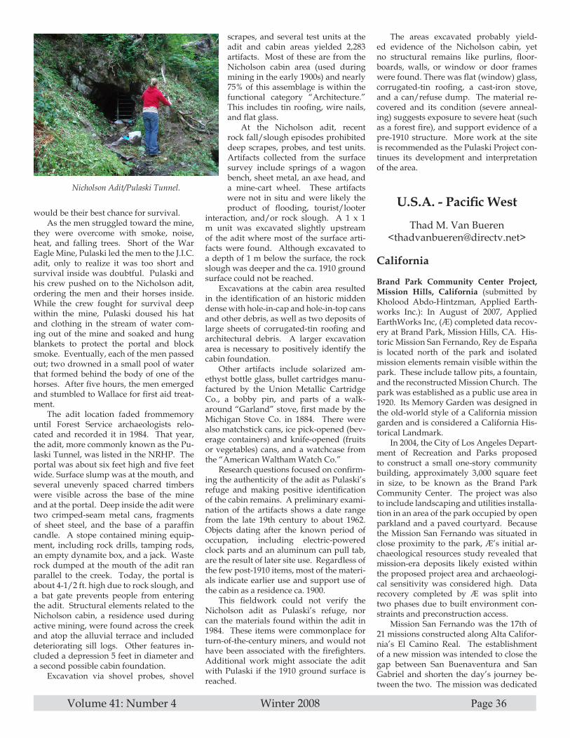
Volume 41: Number 4 Winter 2008 Page 36
would be their best chance for survival.As the men struggled toward the mine,
they were overcome with smoke, noise, heat, and falling trees. Short of the War Eagle Mine, Pulaski led the men to the J.I.C. adit, only to realize it was too short and survival inside was doubtful. Pulaski and his crew pushed on to the Nicholson adit, ordering the men and their horses inside. While the crew fought for survival deep within the mine, Pulaski doused his hat and clothing in the stream of water com-ing out of the mine and soaked and hung blankets to protect the portal and block smoke. Eventually, each of the men passed out; two drowned in a small pool of water that formed behind the body of one of the horses. After five hours, the men emerged and stumbled to Wallace for first aid treat-ment.
The adit location faded frommemory until Forest Service archaeologists relo-cated and recorded it in 1984. That year, the adit, more commonly known as the Pu-laski Tunnel, was listed in the NRHP. The portal was about six feet high and five feet wide. Surface slump was at the mouth, and several unevenly spaced charred timbers were visible across the base of the mine and at the portal. Deep inside the adit were two crimped-seam metal cans, fragments of sheet steel, and the base of a paraffin candle. A stope contained mining equip-ment, including rock drills, tamping rods, an empty dynamite box, and a jack. Waste rock dumped at the mouth of the adit ran parallel to the creek. Today, the portal is about 4-1/2 ft. high due to rock slough, and a bat gate prevents people from entering the adit. Structural elements related to the Nicholson cabin, a residence used during active mining, were found across the creek and atop the alluvial terrace and included deteriorating sill logs. Other features in-cluded a depression 5 feet in diameter and a second possible cabin foundation.
Excavation via shovel probes, shovel
scrapes, and several test units at the adit and cabin areas yielded 2,283 artifacts. Most of these are from the Nicholson cabin area (used during mining in the early 1900s) and nearly 75% of this assemblage is within the functional category “Architecture.” This includes tin roofing, wire nails, and flat glass.
At the Nicholson adit, recent rock fall/slough episodes prohibited deep scrapes, probes, and test units. Artifacts collected from the surface survey include springs of a wagon bench, sheet metal, an axe head, and a mine-cart wheel. These artifacts were not in situ and were likely the product of flooding, tourist/looter
interaction, and/or rock slough. A 1 x 1 m unit was excavated slightly upstream of the adit where most of the surface arti-facts were found. Although excavated to a depth of 1 m below the surface, the rock slough was deeper and the ca. 1910 ground surface could not be reached.
Excavations at the cabin area resulted in the identification of an historic midden dense with hole-in-cap and hole-in-top cans and other debris, as well as two deposits of large sheets of corrugated-tin roofing and architectural debris. A larger excavation area is necessary to positively identify the cabin foundation.
Other artifacts include solarized am-ethyst bottle glass, bullet cartridges manu-factured by the Union Metallic Cartridge Co., a bobby pin, and parts of a walk-around “Garland” stove, first made by the Michigan Stove Co. in 1884. There were also matchstick cans, ice pick-opened (bev-erage containers) and knife-opened (fruits or vegetables) cans, and a watchcase from the “American Waltham Watch Co.”
Research questions focused on confirm-ing the authenticity of the adit as Pulaski’s refuge and making positive identification of the cabin remains. A preliminary exami-nation of the artifacts shows a date range from the late 19th century to about 1962. Objects dating after the known period of occupation, including electric-powered clock parts and an aluminum can pull tab, are the result of later site use. Regardless of the few post-1910 items, most of the materi-als indicate earlier use and support use of the cabin as a residence ca. 1900.
This fieldwork could not verify the Nicholson adit as Pulaski’s refuge, nor can the materials found within the adit in 1984. These items were commonplace for turn-of-the-century miners, and would not have been associated with the firefighters. Additional work might associate the adit with Pulaski if the 1910 ground surface is reached.
The areas excavated probably yield-ed evidence of the Nicholson cabin, yet no structural remains like purlins, floor-boards, walls, or window or door frames were found. There was flat (window) glass, corrugated-tin roofing, a cast-iron stove, and a can/refuse dump. The material re-covered and its condition (severe anneal-ing) suggests exposure to severe heat (such as a forest fire), and support evidence of a pre-1910 structure. More work at the site is recommended as the Pulaski Project con-tinues its development and interpretation of the area.
U.S.A. - Pacific West
Thad M. Van Bueren<[email protected]>
California
Brand Park Community Center Project, Mission Hills, California (submitted by Kholood Abdo-Hintzman, Applied Earth-works Inc.): In August of 2007, Applied EarthWorks Inc, (Æ) completed data recov-ery at Brand Park, Mission Hills, CA. His-toric Mission San Fernando, Rey de España is located north of the park and isolated mission elements remain visible within the park. These include tallow pits, a fountain, and the reconstructed Mission Church. The park was established as a public use area in 1920. Its Memory Garden was designed in the old-world style of a California mission garden and is considered a California His-torical Landmark.
In 2004, the City of Los Angeles Depart-ment of Recreation and Parks proposed to construct a small one-story community building, approximately 3,000 square feet in size, to be known as the Brand Park Community Center. The project was also to include landscaping and utilities installa-tion in an area of the park occupied by open parkland and a paved courtyard. Because the Mission San Fernando was situated in close proximity to the park, Æ’s initial ar-chaeological resources study revealed that mission-era deposits likely existed within the proposed project area and archaeologi-cal sensitivity was considered high. Data recovery completed by Æ was split into two phases due to built environment con-straints and preconstruction access.
Mission San Fernando was the 17th of 21 missions constructed along Alta Califor-nia’s El Camino Real. The establishment of a new mission was intended to close the gap between San Buenaventura and San Gabriel and shorten the day’s journey be-tween the two. The mission was dedicated
Nicholson Adit/Pulaski Tunnel.
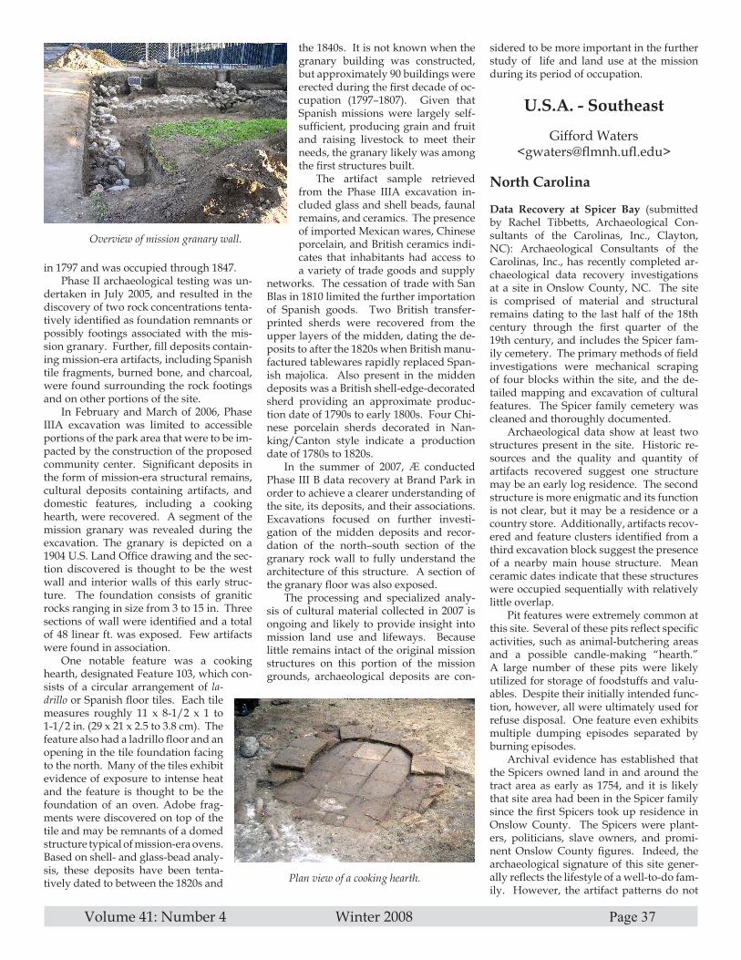
Volume 41: Number 4 Winter 2008 Page 37
in 1797 and was occupied through 1847.Phase II archaeological testing was un-
dertaken in July 2005, and resulted in the discovery of two rock concentrations tenta-tively identified as foundation remnants or possibly footings associated with the mis-sion granary. Further, fill deposits contain-ing mission-era artifacts, including Spanish tile fragments, burned bone, and charcoal, were found surrounding the rock footings and on other portions of the site.
In February and March of 2006, Phase IIIA excavation was limited to accessible portions of the park area that were to be im-pacted by the construction of the proposed community center. Significant deposits in the form of mission-era structural remains, cultural deposits containing artifacts, and domestic features, including a cooking hearth, were recovered. A segment of the mission granary was revealed during the excavation. The granary is depicted on a 1904 U.S. Land Office drawing and the sec-tion discovered is thought to be the west wall and interior walls of this early struc-ture. The foundation consists of granitic rocks ranging in size from 3 to 15 in. Three sections of wall were identified and a total of 48 linear ft. was exposed. Few artifacts were found in association.
One notable feature was a cooking hearth, designated Feature 103, which con-sists of a circular arrangement of la-drillo or Spanish floor tiles. Each tile measures roughly 11 x 8-1/2 x 1 to 1-1/2 in. (29 x 21 x 2.5 to 3.8 cm). The feature also had a ladrillo floor and an opening in the tile foundation facing to the north. Many of the tiles exhibit evidence of exposure to intense heat and the feature is thought to be the foundation of an oven. Adobe frag-ments were discovered on top of the tile and may be remnants of a domed structure typical of mission-era ovens. Based on shell- and glass-bead analy-sis, these deposits have been tenta-tively dated to between the 1820s and
the 1840s. It is not known when the granary building was constructed, but approximately 90 buildings were erected during the first decade of oc-cupation (1797–1807). Given that Spanish missions were largely self-sufficient, producing grain and fruit and raising livestock to meet their needs, the granary likely was among the first structures built.
The artifact sample retrieved from the Phase IIIA excavation in-cluded glass and shell beads, faunal remains, and ceramics. The presence of imported Mexican wares, Chinese porcelain, and British ceramics indi-cates that inhabitants had access to a variety of trade goods and supply
networks. The cessation of trade with San Blas in 1810 limited the further importation of Spanish goods. Two British transfer-printed sherds were recovered from the upper layers of the midden, dating the de-posits to after the 1820s when British manu-factured tablewares rapidly replaced Span-ish majolica. Also present in the midden deposits was a British shell-edge-decorated sherd providing an approximate produc-tion date of 1790s to early 1800s. Four Chi-nese porcelain sherds decorated in Nan-king/Canton style indicate a production date of 1780s to 1820s.
In the summer of 2007, Æ conducted Phase III B data recovery at Brand Park in order to achieve a clearer understanding of the site, its deposits, and their associations. Excavations focused on further investi-gation of the midden deposits and recor-dation of the north–south section of the granary rock wall to fully understand the architecture of this structure. A section of the granary floor was also exposed.
The processing and specialized analy-sis of cultural material collected in 2007 is ongoing and likely to provide insight into mission land use and lifeways. Because little remains intact of the original mission structures on this portion of the mission grounds, archaeological deposits are con-
sidered to be more important in the further study of life and land use at the mission during its period of occupation.
U.S.A. - Southeast
Gifford Waters <[email protected]>
North Carolina
Data Recovery at Spicer Bay (submitted by Rachel Tibbetts, Archaeological Con-sultants of the Carolinas, Inc., Clayton, NC): Archaeological Consultants of the Carolinas, Inc., has recently completed ar-chaeological data recovery investigations at a site in Onslow County, NC. The site is comprised of material and structural remains dating to the last half of the 18th century through the first quarter of the 19th century, and includes the Spicer fam-ily cemetery. The primary methods of field investigations were mechanical scraping of four blocks within the site, and the de-tailed mapping and excavation of cultural features. The Spicer family cemetery was cleaned and thoroughly documented.
Archaeological data show at least two structures present in the site. Historic re-sources and the quality and quantity of artifacts recovered suggest one structure may be an early log residence. The second structure is more enigmatic and its function is not clear, but it may be a residence or a country store. Additionally, artifacts recov-ered and feature clusters identified from a third excavation block suggest the presence of a nearby main house structure. Mean ceramic dates indicate that these structures were occupied sequentially with relatively little overlap.
Pit features were extremely common at this site. Several of these pits reflect specific activities, such as animal-butchering areas and a possible candle-making “hearth.” A large number of these pits were likely utilized for storage of foodstuffs and valu-ables. Despite their initially intended func-tion, however, all were ultimately used for refuse disposal. One feature even exhibits multiple dumping episodes separated by burning episodes.
Archival evidence has established that the Spicers owned land in and around the tract area as early as 1754, and it is likely that site area had been in the Spicer family since the first Spicers took up residence in Onslow County. The Spicers were plant-ers, politicians, slave owners, and promi-nent Onslow County figures. Indeed, the archaeological signature of this site gener-ally reflects the lifestyle of a well-to-do fam-ily. However, the artifact patterns do not
Overview of mission granary wall.
Plan view of a cooking hearth.

Volume 41: Number 4 Winter 2008 Page 38
correspond well with any of the established artifact patterns. This ambiguity has much to do with the paucity of archaeological work that has been conducted on colonial and early American sites in coastal North Carolina.
“Plantations” in Onslow County do not fit the typical picture of the southern U.S. plantation as characterized by tracts of lands devoted to rice, indigo, tobacco, or cotton crops. However, the abundant lon-gleaf pine that flourished in the sandy soil provided the resources, in the form of naval stores, to drive the plantation system of On-slow County and the North Carolina coast-al plain. While North Carolinian plantation owners made use of more indentured ser-vants than did their counterparts elsewhere
in the South, they, too, depended on slave labor for the success of their plantations. Although archival accounts document ex-tensive slave ownership by the Spicer fam-ily, the primary hallmark of slave presence, colonoware, was sparse. This fact com-bined with the documented roles of slaves in the local market economy requires us to closely examine our interpretations of arti-fact assemblages and to learn to recognize the presence of African American slaves whose possessions consisted solely of Eu-ropean goods.
The importance of the investigations at this site lies largely in the fact that little archaeological work has been done in the coastal region of North Carolina on 18th- and early-19th-century rural sites, and virtually none has been done in Onslow County. The lack of data is exacerbated by the fact that colonial and antebellum North Carolina (and especially Onslow County) do not appear to subscribe to the “typical” southern plantation or farm system. The data we have collected is thus even more valuable as we try to make sense of the state’s past. As more investigations of these types of sites are conducted, it is hoped that the data retrieved from this site will con-
tribute substantially to the establishment of patterns reflecting the lifeways of coastal North Carolina plantations during the 18th and 19th centuries.
Brunswick Town/Fort Anderson State Historic Site (submitted by Thomas E. Bea-man, Jr., Wake Technical Community Col-lege, Raleigh, NC): Visitors to the Bruns-wick Town/Fort Anderson State Historic Site have long been accustomed to walk-ing around the historic architectural and archaeological features on sandy paths, just as the residents of the town did in co-lonial times. However, to comply with the Americans with Disabilities Act (ADA) and provide an alternative for visitors who may have had trouble negotiating the sandy trails, the construction of a paved sidewalk is planned for the site. As the proposed route of the paving would be approximately 4400 ft. in length, and would wind through the ruins of the colonial-period households and around the earthen mounds of Fort An-derson, several days of intensive archaeo-logical and geophysical investigation were conducted to insure that no undiscovered or intact cultural resources would be dis-turbed or destroyed by the project.
Assistant State Archaeologist John J. Mintz (Office of State Archaeology), who directed these investigations in cooperation with Site Manager Brenda Marshburn, re-alized that with the abundance of archaeo-logical resources remaining at 18th-century Brunswick Town and 19th-century Fort Anderson, a single methodological ap-proach would not be sufficient to explore the proposed construction route. As such, Mintz divided this archaeological explo-ration into three smaller stages. The first stage was conducted on 19 May and 9 June, when members of the United States Marine Corps Explosive Disposal Team from Camp Lejeune conducted a sweep for unexploded ordnance along the portion of the proposed route that extends through the mounds of Fort Anderson. Thankfully no unexploded artillery shells were discovered, though fragments of at least five shells and a com-plete 1859 model Austrian bayonet were recovered. These metal fragments are pres-ently undergoing conservation at the Office of State Archaeology Research Center in Raleigh, and will be back on display at the site in time for the forthcoming Civil War sesquicentennial celebration.
The next stage involved the excava-tion of shovel test units along the entire proposed route. Mintz was assisted by longtime Brunswick Town researcher and archaeologist Thomas E. Beaman, Jr. (Wake Technical Community College); Queen Anne’s Revenge Project Manager Mark Wilde-Ramsing; Madeline “Punk” Spencer
(Underwater Archaeology Office at Kure Beach); Site Manager Brenda Marshburn; site staff members Jim McKee, Megan Phillips, Kent Snyder, and Chris Jackson; site intern Jennifer Gabriel; and 22 very capable local volunteers and members of the Friends of Brunswick Town support group. With this enthusiastic group, on a very hot 24 June a total of 160 shovel test units were excavated along the proposed walkway route through the town and fort areas. While over 2500 colonial-period ar-tifacts of all types were recovered, one of the most important features documented was the buried layers of hard-packed sand that were the original streets in the town. Though the past excavations by Lawrence Lee and Stanley South had focused more on the household ruins and the fort, the cur-rent excavations revealed that they had cor-rectly restored the streets along their origi-nal locations as shown on Sauthier’s 1769 town map.
Given the possibility of unmarked graves, the one area of the proposed walk-way that Mintz and his colleagues and volunteers did not explore with shovel test units was around Saint Phillips Church. The third and final phase of the project was conducted on 8 July, when Mintz returned to the site with archaeologist Kevin Donald (Office of State Archaeology Cemetery Sur-vey and Stewardship Program) and geo-physical archaeologist Shawn Patch (New South Associates, Inc.). Patch was contract-ed to undertake a ground-penetrating ra-dar (GPR) survey of an approximately 897 m2 cemetery area adjacent to Saint Phillips Church that will be impacted by the walk-way construction. GPR is a remote-sensing technique that allows archaeologists to lo-cate belowground features in a noninva-sive, nondestructive, quick, efficient, and highly accurate manner. It also allows the data to be analyzed quickly, stored for fu-ture use, and be easily replicated. The use of GPR has been highly effective in locat-ing unmarked burials, as was recently demonstrated at Bentonville Battleground State Historic Site. Around Saint Phil-lips Church, while numerous subsurface anomalies—some of which are very likely unmarked burials—were identified in the GPR study, none were situated within the proposed route of the walkway. Thanks to careful planning and execution of the three stages undertaken as part of this project, as well as the efforts of many archaeologists, site staff, and volunteers, the eventual con-struction of the paved walkway will have no negative effects on the important and ir-replaceable cultural resources at Brunswick Town/Fort Anderson State Historic Site.
James Iredell House, Edenton: The ca.
Excavation of one of the structures at an On-slow County site.

Volume 41: Number 4 Winter 2008 Page 39
1799 James Iredell House and its associated lot of the Historic Edenton State Historic Site has also been the subject of several re-cent archaeological investigations. First, on 19 June 2008 Assistant State Archaeologist John J. Mintz (Office of State Archaeology) examined an area to the north of the resi-dence that is the proposed site for the relo-cation of a ca. 1827 kitchen building from Bandon Plantation in northern Chowan County. Mintz, assisted by Site Manager Linda Eure, staff members Blake Harmon and George Lassiter, summer intern Rachel Forehand, longtime Edenton avocational archaeologist Madison Phillips, and several local volunteers, excavated 14 test units within an approximately 400 ft.2 area in the yard for the proposed footprint of the kitch-en and temporary storage shed. Artifacts obtained from these units were generally domestic in nature, and consisted primarily of architectural (window glass, nails, brick
and mortar fragments) and kitchen-related artifacts (pharmaceutical bottles, ceramics, and wine-bottle fragments) that were prob-ably associated with the everyday activi-ties of the site’s occupants. These excava-tions determined that the relocation of the kitchen to this location would not disturb or destroy any important archaeological evidence.
In early July, archaeologist Thomas E. Beaman, Jr. (Wake Technical Community College) directed excavations at the Iredell House in preparation for the waterproofing of the foundation and installation of gutters along the rear of the residence. Assisted by archaeologist Bill Terrell (Wake Forest University Public Archaeology Labora-tory), student Amanda Keeny (East Caro-lina University), and many of those who had assisted Mintz in June—Linda Eure, Madison Phillips, Rachel Forehand, Blake Harmon, George Lassiter, and Carol Ow-
ens—Beaman oversaw the excavation of three large test units along the east founda-tion wall. Specific archaeological features noted include a builder’s trench, evidence of several possible ornamental plantings, and part of a small packed-sand walkway shown on Sauthier’s 1769 map of the town. Beaman also monitored a mechanically dug trench along the entire width of the prop-erty for drain lines associated with the new gutters. A tremendous amount of infilling that dated to the early 20th century was dis-covered along the western edge of the lot, likely placed there to cover a small creek that is shown on many historic maps of the town. This evidence, when combined with the other eight archaeological investi-gations that have been carried out in and around the Iredell House since 1972, pro-vides a clear portrait of the evolution of this important urban lot.
Just because it’s January doesn’t mean we can’t go to the beach!
MAKE PLANS NOW FOR SHA 2010 January 6-9
AMELIA ISLAND PLANTATION near Jacksonville,in BEAUTIFUL, SUNNY FLORIDA!
Where our theme will be:
COASTAL CONNECTIONS:INTEGRATING TERRESTRIAL AND UNDERWATER ARCHAEOLOGY
Amelia Island Plantation (www.aipfl.com) is a 1350-acre (546-hectare) island resort situated between the Atlantic Ocean and the In-tracoastal Waterway, just 29 miles (46 km) from Jacksonville International Airport. Average temperature in January is a balmy 65°F (18°C).
Conference attendees will experience presentations and workshops on cutting-edge research, techniques, methods, and theory while surrounded by palm trees, heated pools, and beachside events. Off-site tours will take participants back in time at nearby Kingsley Plantation, Ft. Clinch, and St. Augustine, the nation’s oldest continuously occupied city dating to 1565 (and you thought Jamestown was historic). Did we also mention the archaeology-themed Drinks of the Day?
Students! Be sure to bring your university ID cards for daily specials on food and beverages. Student groups are welcome and room or villa sharing is a great financial option while attending the SHA Conference. This is one conference you don’t want to miss!
Introducing the 2010 Conference Committee:Della Scott-Ireton – Northwest Region Director, FPAN – Conference ChairAmanda Evans – Marine Archaeologist, Tesla Offshore – Program Chair
John McCarthy – Principal Archaeologist/Historian, S&ME – Terrestrial Program DirectorChris Horrell – Marine Archaeologist, MMS – Underwater Program DirectorSarah Miller – Northeast Region Director, FPAN – Popular Program Director
Amber Grafft-Weiss – Northeast Region Outreach Coordinator, FPAN – Popular Program AssistantRobin Moore – Archaeologist, St. Johns County – Local Arrangements Chair
Chuck Meide – Director, LAMP – Volunteer Co-DirectorDebe Thompson – Volunteer Coordinator, St. Augustine Lighthouse Museum – Volunteer Co-Director

Volume 41: Number 4 Winter 2008 Page 40
THE SOCIETY FOR HISTORICAL ARCHAEOLOGY NEWSLETTER
Please note the deadlines for submissions of newsfor UPCOMING ISSUES of the SHA Newsletter
Spring 2009 . . . . . 1 February 2009Summer 2009 . . . . . 1 May 2009Fall 2009 . . . . . 1 August 2009
Winter 2009 . . . . . 1 November 2009
SHA Business Office9707 Key West Avenue, Suite 100
Rockville, MD 20850Phone: 301.990.2454
Fax: 301.990.9771Email: <[email protected]>
SHA Newsletter Editor Alasdair Brooks: <[email protected]>
SHA 2010
Amelia Island
WWW.SHA.ORG/ABOUT/CON-FERENCES/2010.HTML